
Analysis on Coupling Coordination Degree Between Livelihood Strategy for Peasant Households and Land Use Behavior in Ecological Conservation Areas—A Case Study of the Chang-Zhu-Tan Ecological Greenheart Area

Abstract
1. Introduction
2. Overview of the Study Area and Data Sources
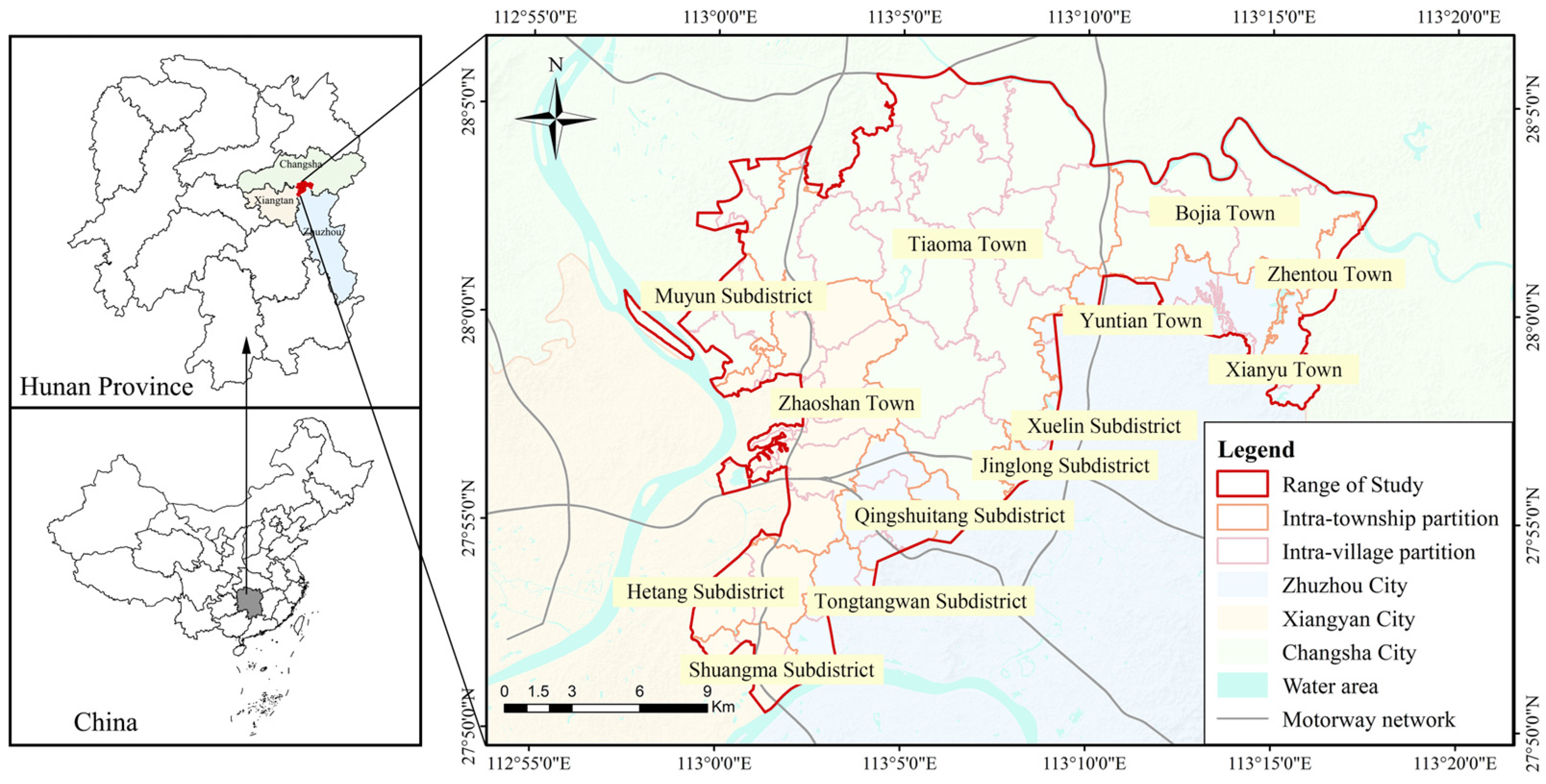
2.1. Study Area Overview
2.2. Data Sources
3. Research Methods
3.1. Classification of Farmer Livelihood Types
3.2. The Development of the Evaluation Index System
3.3. Data Standardization and Weight Determination of Indicators
3.3.1. Data Standardization
3.3.2. Determination of Indicator Weights
- (1)
- Based on the results of data standardization, calculate the proportion Pij of the i-th sample under the j-th indicator using the following expression, where Uij is the standardized value of the j-th indicator for the i-th sample:
- (2)
- Calculate the entropy value of the evaluation indicators:
- (3)
- Calculate the difference coefficient of the indicators:
- (4)
- Determine the weights of the evaluation indicators:
3.4. Coupling Coordination Model
3.4.1. Calculate the Coupling Degree Between Rural Household Livelihood Strategies and Land Use Behaviors
3.4.2. Calculate the Coupling Coordination Degree Between the Rural Household Livelihood Strategy System and the Land Use System
4. Results Analysis
4.1. Analysis of the Coupling Relationship Between Rural Household Livelihood Strategies and Land Use Behavior Systems
- (1)
- The coupling degree value for pure agricultural cultivation households is 0.998. This indicates that their livelihood focus is highly concentrated on agricultural production, with over 95% of their income derived from agricultural planting. These households have extensive planting experience, and almost all, or the vast majority of, their livelihood capital is invested in land use. For example, in Bajia Town, Liuyang, some households engage in mechanized planting by contracting large areas of land, devoting their main efforts and resources to agricultural production. Thus, a strong correlation exists between their livelihood strategies and land use behaviors.
- (2)
- Agricultural sideline households engage in both agricultural production and non-agricultural activities. Their income structure is predominantly agricultural, with agricultural income accounting for over 60%. These households typically use traditional planting methods, have low levels of specialization, small production scales, and fragmented land use. Their production activities display a pronounced “tidal” pattern, focusing on agricultural cultivation during busy seasons such as spring plowing and autumn harvest and shifting to non-agricultural activities during other times. For example, in Yuntian Town, Zhuzhou City, households mainly engage in the cultivation of flowers and seedlings during the off-season. In Bajia Town, Liuyang City, households are involved in the breeding of agricultural products. In Tiaoma Town, Yuhua District, households develop the tourism industry in reliance on Shiyan Lake Park. This production model leads to a lower correlation between their livelihood strategies and land use behaviors compared to pure agricultural cultivation households.
- (3)
- Non-agricultural sideline households primarily engage in non-agricultural production, with agricultural production as a secondary activity. The allocation of their livelihood capital is mainly focused on non-agricultural activities. Survey data indicate that this type of household is the youngest among the three types and has the highest level of education. Their sources of income are diverse. Since some of these households reside in the suburban areas of urban districts, their cultivated land is often located at a considerable distance from their residences, leading to inconvenient land use, high rates of idle arable land, and even vacant rural housing. For example, surveys in Tiaoma Town, Yuhua District, and Yuntian Town, Zhuzhou City, show that approximately 18 village collectives within the ecological protection area of the Green Heart have vacant homesteads. Therefore, these households significantly reduce their time, labor, and agricultural material inputs in land use, resulting in the lowest correlation between their livelihood strategies and land use behaviors and the weakest degree of interaction compared to pure agricultural cultivation households.
4.2. Analysis of the Coupling Coordination Relationship—Rural Household Livelihood Strategies and Land Use Behavior Systems
- (1)
- The coupling coordination degree of pure agricultural cultivation households is 0.557, indicating a barely coordinated development stage. Despite having relatively large planting areas and per capita arable land areas, these households exhibit low land use efficiency. Moreover, the soil in the Chang-Zhu-Tan Green Heart Ecological Conservation Area is contaminated with heavy metals, and the excessive use of pesticides and fertilizers has caused a decline in soil fertility. This has not only reduced crop yields but also decreased household incomes. The evaluation indices for their livelihood strategies and land use behaviors are relatively low at 0.303 and 0.318, respectively. These figures suggest that, without adjustments and guidance to their livelihood strategies, the coupling relationship of these households may further deteriorate, potentially disrupting the coordinated development of regional ecology and economy.
- (2)
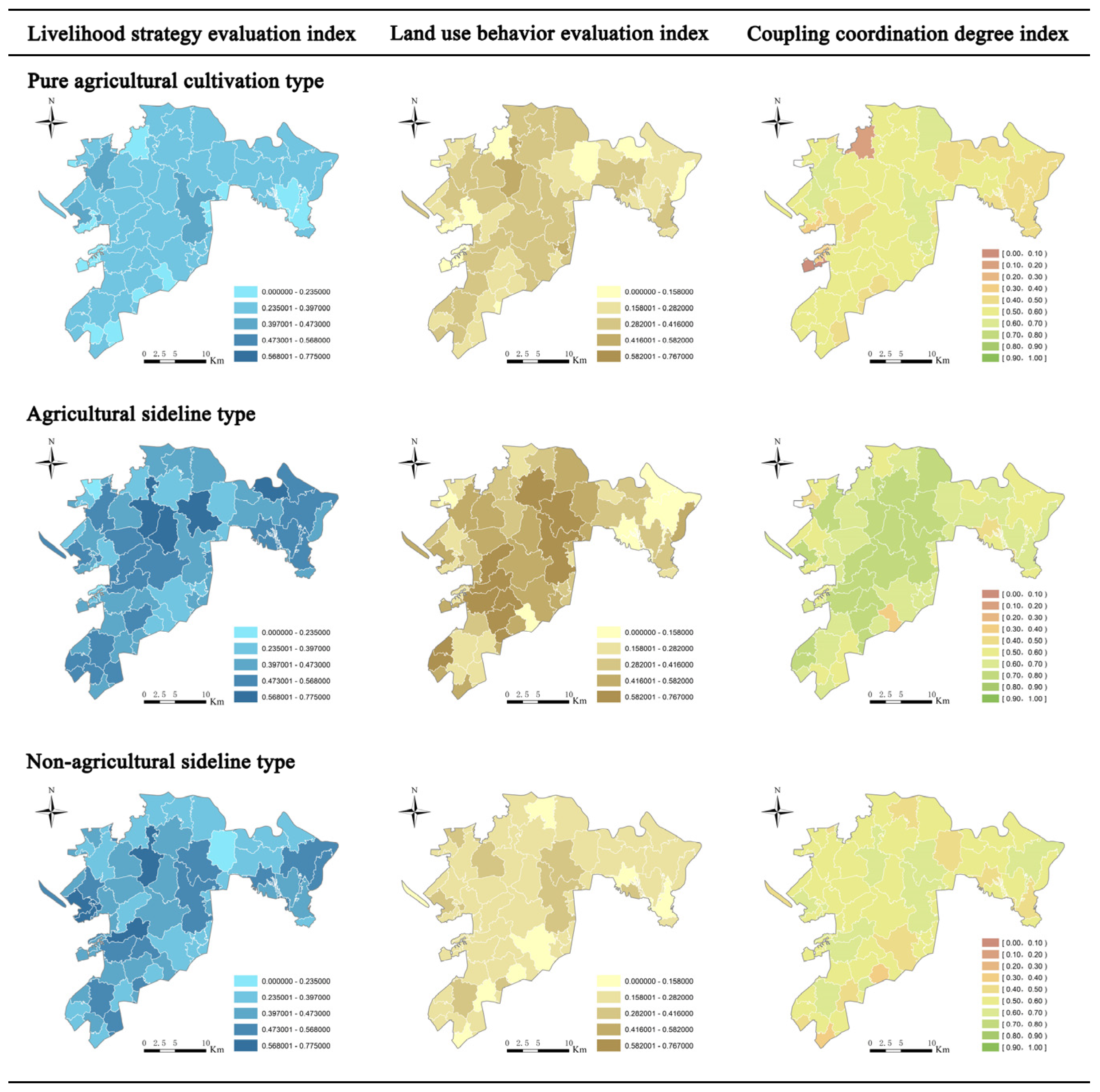
- Non-agricultural sideline households have the smallest land management scale. Their agricultural production is primarily for self-sufficiency, resulting in low comprehensive land use effects. The improvement of their livelihood conditions mainly depends on non-agricultural activities, such as working or engaging in business. As a result, their livelihood strategy evaluation index is higher than that of pure agricultural cultivation households, reaching 0.437. However, the degree of coordinated development between their livelihood strategies and land use behaviors is the lowest at only 0.499, indicating a stage close to disordered decline. This suggests that, among non-agricultural sideline households, the support of land use behavior for livelihood strategies is relatively weak. As shown in Figure 3, households with low coupling coordination degrees are mainly concentrated in the transitional areas between the ecological protection zone and urban areas, such as Mu Yun Street, Tongsheng Lake Street, Jinglong Street, and Shuangma Street. In these areas, land and households are significantly affected by urban expansion and urban suction phenomena. On the one hand, land transfer phenomena increase, and some households lose their land and gradually become urban residents. On the other hand, the opportunities for diversified livelihoods for households increase and the attractiveness and utilization rate of land for households gradually decrease. Therefore, the coupling coordination relationship between land use structure and livelihood strategies urgently needs to be optimized to enhance the overall coordination and sustainability of the system.
- (3)
- The livelihood activities of agricultural sideline households are primarily focused on agricultural production. Compared to non-agricultural sideline households, they have significant advantages in natural capital. However, compared to pure agricultural cultivation households, their land input arrangements, particularly in labor capital input and time allocation, are more scientific, resulting in relatively higher land use efficiency. Therefore, the land use behavior evaluation index of this type of household is the highest at 0.533. The improvement of their livelihood capital status mainly depends on agricultural production, with non-agricultural activities serving as supplementary means. Based on this, the coordinated development degree of livelihood strategies and land use behaviors for agricultural sideline households is 0.693, indicating an initial coordinated development stage. This stage suggests that the coupling coordination relationship between their livelihood strategies and land use behaviors has been preliminarily formed but still requires further optimization to enhance the overall coordination and sustainability of the system.
4.3. Regional Differences in the Coupling Coordination Degree of Rural Household Livelihood Strategies and Land Use Behaviors Within the Green Heart Ecological Protection Area
- (1)
- Overall, the coupling coordination degree of rural areas in the central region of the Green Heart Ecological Protection Area is higher than that in the peripheral regions. Specifically, the coupling coordination degree in some rural areas of Tiaoma Town, Yuntian Town, and Zhaoshan Town is generally higher than that in other rural areas. The main reasons for this differentiation are as follows: ① The relatively flat terrain in the central region provides more favorable transportation conditions for agricultural production. This not only reduces the transportation costs of agricultural products but also creates favorable prerequisites for the commercialization of agriculture, making the production and living functions of land more significant. Additionally, since this area is located in the central position and is farther from the surrounding cities, it is less affected by urban expansion and urban suction effects. The stability of agricultural production land is ensured, providing strong support for the sustainable development of agricultural production. ② In the central areas, the population is more concentrated, and the labor force is more abundant. There is a sufficient number of workers engaged in sideline activities, and the educational level of the labor force is significantly higher. These workers are proactive in receiving agricultural technical training and are willing to try and adopt more advanced agricultural production and management methods, resulting in a higher input–output ratio. ③ The livelihood strategies of agricultural sideline households in the central areas are more diverse. For example, in Tiaoma Town, in addition to cultivating crops, households also grow a large number of ornamental plants, such as palm trees, camphor trees, magnolias, and pines. The total area for the cultivation of flowers and seedlings has reached approximately 86,667 acres. Relying on the resource advantages of Shiyan Lake Ecological Park, Tiaoma Town actively participates in tourism services, forming a diversified livelihood pattern.
- (2)
- As regional protection and control measures are intensified, the coupling coordination degree of rural household livelihood strategies and land use behaviors within the Green Heart Ecological Protection Area exhibits a progressively increasing trend, specifically Prohibited Development Zones > Restricted Development Zones > Controlled Construction Zones. The primary reasons for the observed differentiation are as follows: ① The strictest project admission management system is implemented in the prohibited development zones, which significantly guides the livelihood strategy choices of rural households and their land use behaviors and patterns. This system not only regulates land development and utilization but also effectively protects the natural environment. The forest land, cultivated land, and garden land within the area, along with the high-quality soil texture, provide unique conditions for efficient agricultural output and the cultivation of flowers and seedlings. These resources also constitute an important livelihood capital for agricultural households. The combined effects of policy and resource endowment lead to a high degree of consistency between the livelihood strategies and land use behaviors of rural households in the area, thereby significantly enhancing the coupling coordination degree. ② In accordance with the “Chang-Zhu-Tan Urban Agglomeration Ecological Green Heart Area Construction Project Admission Management Measures”, restricted development zones permit the moderate development of tourism and leisure facility construction projects. This provides agricultural sideline households with diversified livelihood options. For instance, in Shiyang Lake Village, households leverage the resource advantages of Shiyang Lake Ecological Park to convert idle rural houses into distinctive homestays and develop idle grasslands into tourist landscape areas. They also utilize the surrounding natural landscapes and pastoral scenery to conduct rural homestays, ecological picking, and other leisure agriculture projects. These initiatives not only enhance the comprehensive utilization value of land but also broaden the income sources of rural households, achieving a positive interaction between ecological protection and economic development. The coordination of policy guidance and resource utilization, the transformation of ecological advantages into economic benefits, and the integration and diversification of industries collectively foster the coupling coordination of livelihood strategies and land use behaviors among rural households in the region. ③ Within the controlled construction zone of the Chang-Zhu-Tan Ecological Green Heart Area, the coupling coordination degree is relatively low. Firstly, rural areas in this zone are in close proximity to cities, and frequent land expropriation and transfer disrupt the stability of land use patterns, thereby significantly impacting the livelihood strategies of rural households. Secondly, with the acceleration of urbanization, some local rural households have gradually transitioned to urban residents and engaged in non-agricultural work. This transition weakens the coupling relationship between land use behaviors and livelihood strategies, further reducing the coupling coordination degree. Additionally, the early presence of numerous chemical and building material enterprises in the controlled construction zone led to environmental pollution. These enterprises were ordered by policy to exit, resulting in reduced employment opportunities for local rural households and a further decline in the coupling coordination degree.
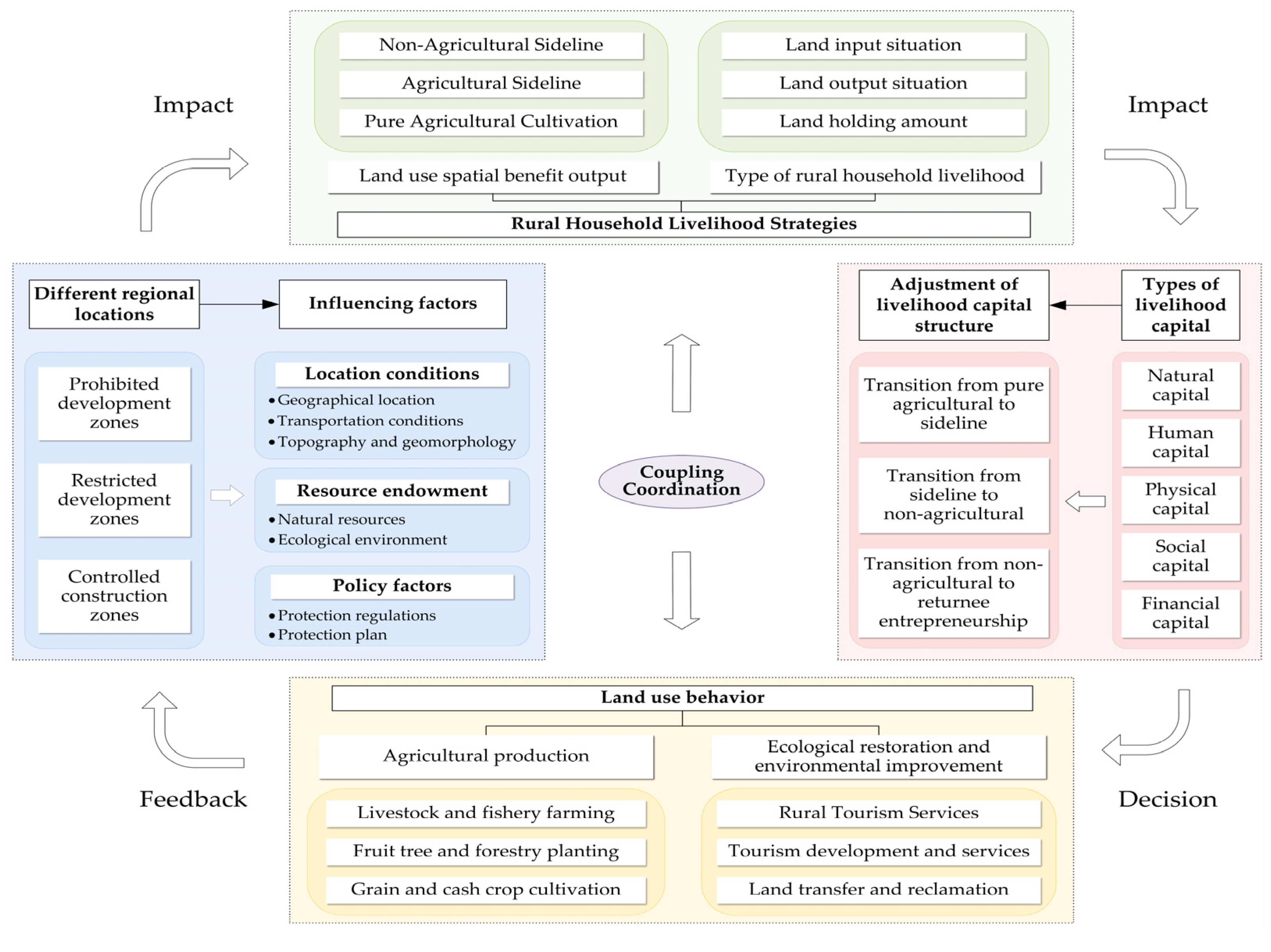
4.4. The Coupling and Coordination Mechanism Between Rural Household Livelihood Strategies and Land Use Behavior in the Green Heart Ecological Protection Zone
5. Conclusions and Discussion
5.1. Conclusions
- (1)
- There is a moderately coupled and coordinated relationship between rural household livelihood strategies and land use behavior. ① In terms of the levels of coupling coordination degree, the coupling coordination degrees of pure agricultural planting households and non-agricultural sideline households are 0.557 and 0.499, respectively, and the overall level is in the moderate coupling range. Among them, the coordination degree of agricultural sideline households is the highest. This is because such households carry out diversified operations on the basis of agricultural production (such as the planting of flowers and seedlings, tourism services, etc.), which not only increases economic income but also reduces ecological pressure. Pure agricultural planting households have a high dependence on single agriculture, with low land use efficiency, and are easily affected by ecological degradation (such as soil pollution). Non-agricultural sideline households have the lowest coordination degree due to high land allocation rates and insufficient investment. ② In terms of the coupling mechanism, households choose livelihood strategies (such as pure agriculture and sideline occupations) through the allocation of livelihood capital (natural, human, physical, etc.), and the efficiency of land resource use affects the structure of the livelihood capital in turn, forming a dynamic feedback loop. Agricultural sideline households achieve a higher positive interaction by scientifically allocating resources (such as reasonably distributing time for farming and sideline occupations).
- (2)
- The regional differentiation characteristics are significant, with policy and location being the key influencing factors. ① Spatial characteristics: The coupling coordination degree exhibits a pattern of “high in the center, low at the edges”. The central areas of the protection zone (such as Tiaoma Town and Zhaoshan Town) have higher coordination degrees due to flat terrain, convenient transportation, abundant labor force, and strict policy constraints. In contrast, the urban suburban areas (such as the controlled construction zones) are subject to the urbanization spillover effect, characterized by frequent land transfer and an increase in non-agricultural employment, which leads to poor land use stability and a decline in coordination degree. ② Policy zoning differences: The strict conservation policies in the prohibited development zones (with the highest coupling coordination degree) encourage households to intensively utilize limited resources (e.g., developing high-efficiency agriculture). The restricted development zones achieve multifunctional land use through tourism development (e.g., ecotourism). The controlled construction zones, due to loose policy enforcement and economic fluctuations, have the lowest coordination degree.
- (3)
- The policy optimization path points towards the coordinated development of ecology and economy. ① Land structure optimization: Promote intensive land transfer in marginal areas to alleviate the fragmentation of arable land (e.g., by promoting the cooperative model), thereby enhancing the production efficiency of pure agricultural households. In the central areas, integrate ecological advantages to expand the forestry and tourism industries. ② Empowerment of green economy: Encourage green business forms such as forest-under economy (e.g., intercropping of medicinal plants under trees) and ecotourism (e.g., farmhouses and nature education), reduce the overreliance on traditional agriculture, and enhance the comprehensive value of land. ③ Improvement of the ecological compensation mechanism: In response to the restrictions on farmers’ resource use rights imposed by conservation policies (such as grazing bans and limited cultivation), it is necessary to establish reasonable ecological compensation standards to safeguard the basic income of farmers. For example, this can be achieved through financial subsidies or by feeding back into farmers’ livelihoods through carbon sink trading.
5.2. Discussion
- (1)
- Livelihood Diversification as a Catalyst for Coupling Coordination
- (2)
- Spatial Heterogeneity Driven by the Policy–Resource Nexus
- (3)
- Methodological Contributions and Future Reflections
- (4)
- Policy Implications for Ecological–Economic Balance
Author Contributions
Funding
Institutional Review Board Statement
Informed Consent Statement
Data Availability Statement
Conflicts of Interest
References
- Chambers, R.; Conway, G.R. Sustainable Rural Livelihoods: Practical Concepts for the 21st Century; Institute of Development Studies: Brighton, UK, 1992. [Google Scholar]
- Liu, X.B.; Wang, Y.K.; Li, M.; Liu, Q.; Zhang, Y.X.; Zhu, Y.Y. Analysis on Coupling Coordination Degree between Livelihood Strategy for Peasant Households and “Production, Living and Ecological” Functions of Lands in Typical Mountainous Areas, China. J. Mt. Res. 2020, 38, 596–607. [Google Scholar]
- Su, F.; Xu, Z.M.; Shang, H.Y. An Overview of sustainable livelihoods Approach. J. Adv. Earth Sci. 2009, 24, 61–69. [Google Scholar]
- Su, F.; Yin, Y.J.; Shang, H.Y. Influencing Factors of Farmers’ Livelihood Risk Perception in Shiyang River Basin of Gansu Province. J. Econ. Geogr. 2019, 39, 191–197. [Google Scholar]
- Zhao, X.Y.; Zhang, L.; Jiang, J.D.; Hou, C.C. The impact of ecological compensation on the farmers’ livelihood: A case study of Huanghe River Water Supply Areas of Gannan. J. Geogr. Res. 2013, 32, 531–542. [Google Scholar]
- Xiong, Y.; Shen, C.L.; Yin, J.J.; Qiu, J.W.; Tang, J.F. Dependence of Farmer Livelihood on Ecological Resources in Key Ecological Function Areas and Its Influencing Factors: A Case Study of Cili County, Hunan Province. J. Econ. Geogr. 2023, 43, 188–197. [Google Scholar]
- Wu, Y.T.Y.; Yang, J. Evolution path of households’ livelihood strategies and its impact on agricultural land use patterns: Based on the investigation of 291 farmer households in Hunan. J. Hunan Agric. Univ. (Soc. Sci. Ed.) 2017, 18, 65–69. [Google Scholar]
- Han, L.; Bao, H.J.; Wang, C.C. International comparison of land-lost farmers’ entrepreneurship policy patterns and their implications. J. Shanghai Land Resour. 2020, 41, 58–63. [Google Scholar]
- Wang, D.; Wang, X.; Hao, H.G.; Lin, Y.D.; Xiao, R. Research Progress on Farmers’ Livelihood Transformation and Its Ecological Effects—A Review. J. Resour. Ecol. 2022, 12, 912–924. [Google Scholar]
- Liang, L.T.; Qu, F.T.; Zhu, P.X.; Ma, K. Analysis of Land Use Behavior and Efficiency of Different Farm Household Types. J. Resour. Sci. 2008, 30, 1525–1532. [Google Scholar]
- Zhang, Z.M.; Qian, W.R. Research on farmers’ willingness to transfer land under different part-time degrees: An investigation and empirical study based on Zhejiang. J. Issues Agric. Econ. 2014, 35, 19–24. [Google Scholar]
- Guo, J.B.; Huang, Q.Z.; Sun, Z.B. Rural households’livelihood and land use in the middle reaches of Yalu Tsang-po River: A case study of Namling in Shigatsc, Tibet. J. Arid Land Resour. Environ. 2019, 33, 128–134. [Google Scholar]
- Cen, Y.Y.; Bao, H.J. The effect of informal training on the human capital of land-lost farmers: Qualitative research from the social network perspective. J. Shanghai Land Resour. 2016, 37, 49–53. [Google Scholar]
- Li, C.Z.; Xu, J.C.; Kong, X.B. Farm household livelihood diversity and land use in suburban areas of metropolis: The case study of Daxing District, Beijing. J. Geogr. Res. 2012, 31, 1039–1049. [Google Scholar]
- Zhang, M.Z.; Meng, M.; Zhu, P.; Chen, L. Reasearch on the impact of livelihood strategies on multi-dimensional poverty of farmers. J. Chin. J. Agric. Mech. 2022, 43, 238–244. [Google Scholar]
- Liu, Y.L.; Liao, H.P.; Cai, B.L.; Shi, Y.M.; Qiu, J.Q. Multidimensional relative poverty measurement and influence mechanism of farm house holds based on different livelihood types. J. China Popul. Resour. Environ. 2022, 32, 165–175. [Google Scholar]
- Zhuang, L.Y. The impact of farmers’ non-agriculturalization on land transfer decisions. J. Stat. Decis. 2020, 4, 82–85. [Google Scholar]
- Wang, C.C.; Yang, Y.S. Impact of Rural Households’Nonfarm Employment on Cropland Transfer—Case of Changting County in Fujian Province, China. J. Geogr. Sci. 2011, 31, 1362–1367. [Google Scholar]
- Zhang, J.Y.; Zhou, X.M.; Wang, L.C.; Wang, X.F. Analysis of cultivated land use transformation from the perspective of farmers’ livelihood. J. Chin. J. Agric. Resour. Reg. Plan. 2023, 44, 48–58. [Google Scholar]
- Su, K.C.; Yang, Q.Y.; Zhang, B.L.; Zhang, Z.X. The coupling mechanism between rural land use transition and small-scale peasant economy change in mountainous areas. J. Geogr. Res. 2019, 38, 399–413. [Google Scholar]
- Zhang, X.R.; Gao, J.Z. An Empirical Analysis of the Utilization Efficiency of Farmers’ CollectiveForest Land from the Perspective of Livelihood Capital. J. Northwest AF Univ. (Soc. Sci. Ed.) 2020, 20, 129–137. [Google Scholar]
- Zhao, L.J.; Kang, X.H.; Shi, J.H. The empirical analysis on the effect of the farmland transfer on households’ livelihood transformation. J. Chin. J. Agric. Resour. Reg. Plan. 2017, 38, 158–162. [Google Scholar]
- Ji, Q. Satisfaction analysis of rural collective land transfer benefits according to farmer endowment and risk cognition: Evidence from Guangzhou city. J. Shanghai Land Resour. 2020, 41, 22–27. [Google Scholar]
- Ren, L.; Zhang, M.; Chen, Y.R. The Relationship between Livelihood Capital, Multi-functional Value Perception of Cultivated Land and Farmers’ Willingness to Land Transfer: A Regional Observations in the Period of Poverty Alleviation and Rural Revitalization. J. China Land Sci. 2022, 36, 56–65. [Google Scholar]
- Bradstock, A. Changing livelihoods and land reform: Evidence from the Northern Cape Province of South Africa. J. World Dev. 2005, 33, 1979–1992. [Google Scholar] [CrossRef]
- Scoones, I.; Marongwe, N.; Mavedzenge, B.; Murimbarimb, F.; Mahenehene, J.; Sukume, C. Livelihoods after land reform in Zimbabwe: Understanding processes of rural differentiation. J. Agrar. Change 2012, 12, 503–527. [Google Scholar] [CrossRef]
- Zhang, C.L.; Tong, L.J.; Liu, J.B. Response of Fam ers to Conversion of Cultivated Land to W etlandand Substitute Livelihood A Case of Sanjiang Reserve. J. Nat. Resour. 2008, 23, 568–574. [Google Scholar]
- Kamwi, J.M.; Chirwa, P.W.C.; Manda, S.O.M.; Graz, P.F.; Kätsch, C. Livelihoods, land use and land cover change in the Zambezi Region, Namibia. J. Popul. Environ. 2015, 37, 207–230. [Google Scholar] [CrossRef]
- Pensuk, A.; Shrestha, R.P. Changes in land use and rural livelihoods: A study of Phatthalung watershed in Southern Thailand. J. Asia-Pac. J. Rural Dev. 2008, 18, 143–164. [Google Scholar] [CrossRef]
- Djanibekov, U.; Djanibekov, N.; Khamzina, A.; Bhaduri, A.; Lamers, J.P.A.; Berg, E. Impacts of innovative forestry land use on rural livelihood in a bimodal agricultural system in irrigated drylands. J. Land Use Policy 2013, 35, 95–106. [Google Scholar] [CrossRef]
- Li, X.G.; Liu, J.D.; Huo, X.X. Effects of farmland registration and confirmation on the choice of farmers’livelihood strategy: Evidence from apple growers. J. Resour. Sci. 2019, 41, 1923–1934. [Google Scholar]
- Xu, H.Z.; Tian, H.C. Evaluation on effect of rural land rights confirmation policy implementation under the perspective of household livelihood diversity. J. Arid Land Resour. Environ. 2018, 32, 30–36. [Google Scholar]
- Mccusker, B.; Carr, E.R. The co-production of livelihoods and land use change: Case studies from South Africa and Ghana. J. Geoforum 2006, 37, 790–804. [Google Scholar] [CrossRef]
- Carr, E.R.; Mccusker, B. The co-production of land use and livelihoods change: Implications for development interventions. J. Geoforum 2009, 40, 568–579. [Google Scholar] [CrossRef]
- Sun, X.; Bi, R.T.; Liu, H.F.; Ding, Y.; Ning, F. Effects of Cultivated Land Fragmentation on Farmers’ Livelihood Strategies in Impoverished Mountainous Areas: A Case Study of 87 Villages in Qingzhang River Basin of Zuoquan County. J. China Land Sci. 2018, 32, 40–47. [Google Scholar]
- Jiang, J.J.; Zhang, S.C.; Shao, J.A.; Wang, J.L. Livelihood diversification of farmers and its sustainability level driven by land transfer: Based on the survey data of 188 households in Hechuan District in Chongqing. J. Chin. J. Eco-Agric. 2019, 27, 314–326. [Google Scholar]
- Liu, C.F.; Zhao, W. The Influence of Rural Land Consolidation on Households’ Livelihood Strategies Based on PSM-DID Method. J. Nat. Resour. 2018, 33, 1613–1626. [Google Scholar]
- Zhang, L.; Li, J.; Wu, Y.D. Peasant Households’ Livelihood and Differential Characteristics of Land Use in Multi-Ethnic Symbiosis Area: A Case Study of Zhengjiazhuang Village in Eryuan County of Yunnan. J. Econ. Geogr. 2018, 38, 183–190. [Google Scholar]
- Ding, J.J.; Jin, N.B.; Jia, W.; Yi, X.X.; Wang, Y.M. The livelihood response of rural households to urbanization and its influencing factors in Wuling Mountain area: With the survey data of 355 households in three typical towns. J. Geogr. Res. 2019, 38, 2027–2043. [Google Scholar]
- Li, G.D.; Qiu, D.C.; Wang, L.P.; Wang, P.; Luo, D.Q. Impacts of Difference among Livelihood Assets on the Choice of Economic Compensation Pattern for Farmer Households Farmland Protection in Chongqing City. J. Acta Geogr. Sin. 2012, 67, 504–515. [Google Scholar]
- Jie, Y. Study on land use behavior and Livelihood Strategy of mining farmers based on Sustainable Livelihood—A case study of Ling bei town. Master’s Thesis, East China University of Technology, Shanghai, China, 2021. [Google Scholar] [CrossRef]
- DFID. Sustainable Livelihoods Guidance Sheets; Department for International Development: London, UK, 1999. [Google Scholar]
- He, R.W.; Fang, F.; Liu, Y. Influence of human capital on the livelihood strategy of farming households in poor mountainous areas: Acase study of Liangshan Yi Autonomous Prefecture of Sichuan, China. J. Prog. Geogr. 2019, 38, 1282–1293. [Google Scholar] [CrossRef]
- Matlovicova, K.; Kolesárová, J.; Matlovic, R. Selected Theoretical Aspects of the Destination Marketing Based on Participation of Marginalized Communities. In Proceedings of the 8th International Annual Scientific Conference on Hotel Services, Tourism and Education Location. 2016, pp. 128–143. Available online: https://www.unipo.sk/public/media/16282/EN_DESTINATION%20MARKETING%20BASED%20ON%20PPT.pdf (accessed on 17 April 2024).
- Matloviěová, K. The Triadic Nexus: Understanding the Interplay andSemantic Boundaries Between Place ldentity, Place lmage, and Place Reputation. J. Folia Geogr. 2024, 66, 69–102. [Google Scholar]


| Types of Rural Household Livelihood Strategies | Livelihood Methods | Main Sources of Income and Their Proportions | Sample Size (Households) |
|---|---|---|---|
| Pure agricultural cultivation 1 | Agricultural cultivation | Agricultural cultivation income ≥ 90% | 68 |
| Agricultural sideline | Agricultural cultivation (main) + Non-agricultural | 50% ≤ Agricultural cultivation income ≤ 90% | 65 |
| Non-agricultural sideline | Non-agricultural (main) + Agricultural cultivation | 10% ≤ Agricultural cultivation income ≤ 50% | 142 |
| Pure non-agricultural | Non-agricultural | Agricultural cultivation income ≤ 10% | 124 |
| Subsystems | Primary Indicators | Secondary Indicators | Explanation | Direction of Influence 1 | Weight |
|---|---|---|---|---|---|
| Livelihood strategies | Natural capital | Average arable land area per household X1 | Total arable land area owned by households/hectare | + | 0.093 |
| Actual arable land area per household X2 | Actual cultivated area owned by households/hectare | + | 0.096 | ||
| Human capital | Household head’s age X3 | 1 = Aged 65 and above; 2 = 56–65 years old; 3 = 36–55 years old; 4 = 20–35 years old | + | 0.052 | |
| Household head’s education level X4 | 1 = Primary school and below; 2 = Junior high school; 3 = Senior high school or vocational school; 4 = Junior college and above | + | 0.075 | ||
| Family population size X5 | Total family population | + | 0.081 | ||
| Physical capital | Area of auxiliary production housing owned X6 | 1 = 10 m2 and below; 2 = 11–50 m2; 3 = 51–120 m2; 4 = 120–500 m2 | + | 0.087 | |
| Labor force proportion X7 | Number of family labor force/Total family population | + | 0.143 | ||
| Number of housing units X8 | 1 = 1 room and below; 2 = 2 rooms; 3 = 3 rooms; 4 = More than 3 rooms | + | 0.068 | ||
| Social capital | Presence of village officials in the household X9 | 1 = Yes; 0 = No | + | 0.052 | |
| Expenditure on social obligations X10 | Total annual expenditure on social obligations per family/ten thousand yuan | + | 0.049 | ||
| Financial capital | Agricultural income X11 | Annual agricultural income per rural household/ten thousand yuan | + | 0.129 | |
| Subsidy opportunities X12 | 1 = Yes; 0 = No | + | 0.077 | ||
| Land use behavior | Land holding situation | Per capita arable land area X13 | Total arable land area/Total family population | + | 0.188 |
| Actual cultivated area X14 | Actual cultivated arable land area/hectare | + | 0.192 | ||
| Forest land holding area X15 | Total forest land area owned by households/hectare | + | 0.092 | ||
| Land input situation | Fertilizer input X16 | Fertilizer input/Total arable land area | + | 0.106 | |
| Pesticide input X17 | Pesticide input/Total arable land area | + | 0.094 | ||
| Degree of mechanization use X18 | Mechanized farming area/Total arable land area | + | 0.113 | ||
| Land output situation | Average grain yield per unit area X19 | Total grain output/Total arable land area | + | 0.095 | |
| Average grain output value per unit area X20 | Total grain output value/Total arable land area | + | 0.120 |
| Coupling Degree | Coupling State |
|---|---|
| 0.0 < C ≤ 0.3 | Low-level coupling state |
| 0.3 < C ≤ 0.5 | Antagonistic state |
| 0.5 < C ≤ 0.8 | Break-in state |
| 0.8 < C ≤ 1.0 | High-level coupling state |
| Macro Types | Coupling Coordination Degree | Types of Coordinated Development |
|---|---|---|
| Disordered decline class | [0.00, 0.10) | Extremely disordered decline class |
| [0.10, 0.20) | Severely disordered decline class | |
| [0.20, 0.30) | Moderately disordered decline class | |
| [0.30, 0.40) | Mildly disordered decline class | |
| Transition class | [0.40, 0.50) | On the verge of disordered decline class |
| [0.50, 0.60) | Barely coordinated development class | |
| [0.60, 0.70) | Primary coordinated development class | |
| Coordinated development class | [0.70, 0.80) | Intermediate coordinated development class |
| [0.80, 0.90) | Good coordinated development class | |
| [0.90, 1.00] | High-quality coordinated development class |
| Type of Rural Household Livelihood | Coupling Degree C | Comprehensive Evaluation Index T | Coupling Coordination Degree D | ||
|---|---|---|---|---|---|
| Pure agricultural cultivation type | 0.303 | 0.318 | 0.998 | 0.310 | 0.557 |
| Agricultural sideline type | 0.433 | 0.533 | 0.995 | 0.483 | 0.693 |
| Non-agricultural sideline type | 0.383 | 0.162 | 0.914 | 0.273 | 0.499 |
Disclaimer/Publisher’s Note: The statements, opinions and data contained in all publications are solely those of the individual author(s) and contributor(s) and not of MDPI and/or the editor(s). MDPI and/or the editor(s) disclaim responsibility for any injury to people or property resulting from any ideas, methods, instructions or products referred to in the content. |
© 2025 by the authors. Licensee MDPI, Basel, Switzerland. This article is an open access article distributed under the terms and conditions of the Creative Commons Attribution (CC BY) license (https://creativecommons.org/licenses/by/4.0/).
Share and Cite
Ouyang, J.; Zhang, P.; Yu, H.; Zhang, N.; Liu, Y. Analysis on Coupling Coordination Degree Between Livelihood Strategy for Peasant Households and Land Use Behavior in Ecological Conservation Areas—A Case Study of the Chang-Zhu-Tan Ecological Greenheart Area. Sustainability 2025, 17, 3996. https://doi.org/10.3390/su17093996
Ouyang J, Zhang P, Yu H, Zhang N, Liu Y. Analysis on Coupling Coordination Degree Between Livelihood Strategy for Peasant Households and Land Use Behavior in Ecological Conservation Areas—A Case Study of the Chang-Zhu-Tan Ecological Greenheart Area. Sustainability. 2025; 17(9):3996. https://doi.org/10.3390/su17093996
Chicago/Turabian StyleOuyang, Jingwen, Ping Zhang, Hanwu Yu, Nan Zhang, and Yuan Liu. 2025. "Analysis on Coupling Coordination Degree Between Livelihood Strategy for Peasant Households and Land Use Behavior in Ecological Conservation Areas—A Case Study of the Chang-Zhu-Tan Ecological Greenheart Area" Sustainability 17, no. 9: 3996. https://doi.org/10.3390/su17093996
APA StyleOuyang, J., Zhang, P., Yu, H., Zhang, N., & Liu, Y. (2025). Analysis on Coupling Coordination Degree Between Livelihood Strategy for Peasant Households and Land Use Behavior in Ecological Conservation Areas—A Case Study of the Chang-Zhu-Tan Ecological Greenheart Area. Sustainability, 17(9), 3996. https://doi.org/10.3390/su17093996