
Leveraging Immersive Digital Twins and AI-Driven Decision Support Systems for Sustainable Water Reserves Management: A Conceptual Framework

 ,
, 
Abstract
1. Introduction
2. Materials and Methods
2.1. Conceptual Framework Design and Theoretical Underpinnings
- Improving Real-Time Monitoring: By leveraging digital twins and IoT-based sensors, the framework enables the continuous collection of data on water levels, quality, flow rates, and other key parameters. This real-time monitoring provides water managers with up-to-date insights into the health of water systems and the effectiveness of current management strategies [41,42].
- Providing Immersive Simulations: Using game engines, the framework creates detailed, interactive simulations of water systems that allow users to explore how different variables (e.g., rainfall, temperature, human interventions) affect water resources [43]. These simulations offer an intuitive understanding of complex water dynamics, making it easier for stakeholders to visualize potential outcomes and make informed decisions.
- Fostering Adaptive Water Management Strategies: The framework supports adaptive water management by enabling water managers and communities to test a variety of strategies in a virtual environment before implementing them in the real world. By simulating different scenarios (e.g., floods, droughts, and demand surges), the system allows users to understand the implications of different management approaches, enabling more flexible, responsive decision-making via artificial intelligence (AI).
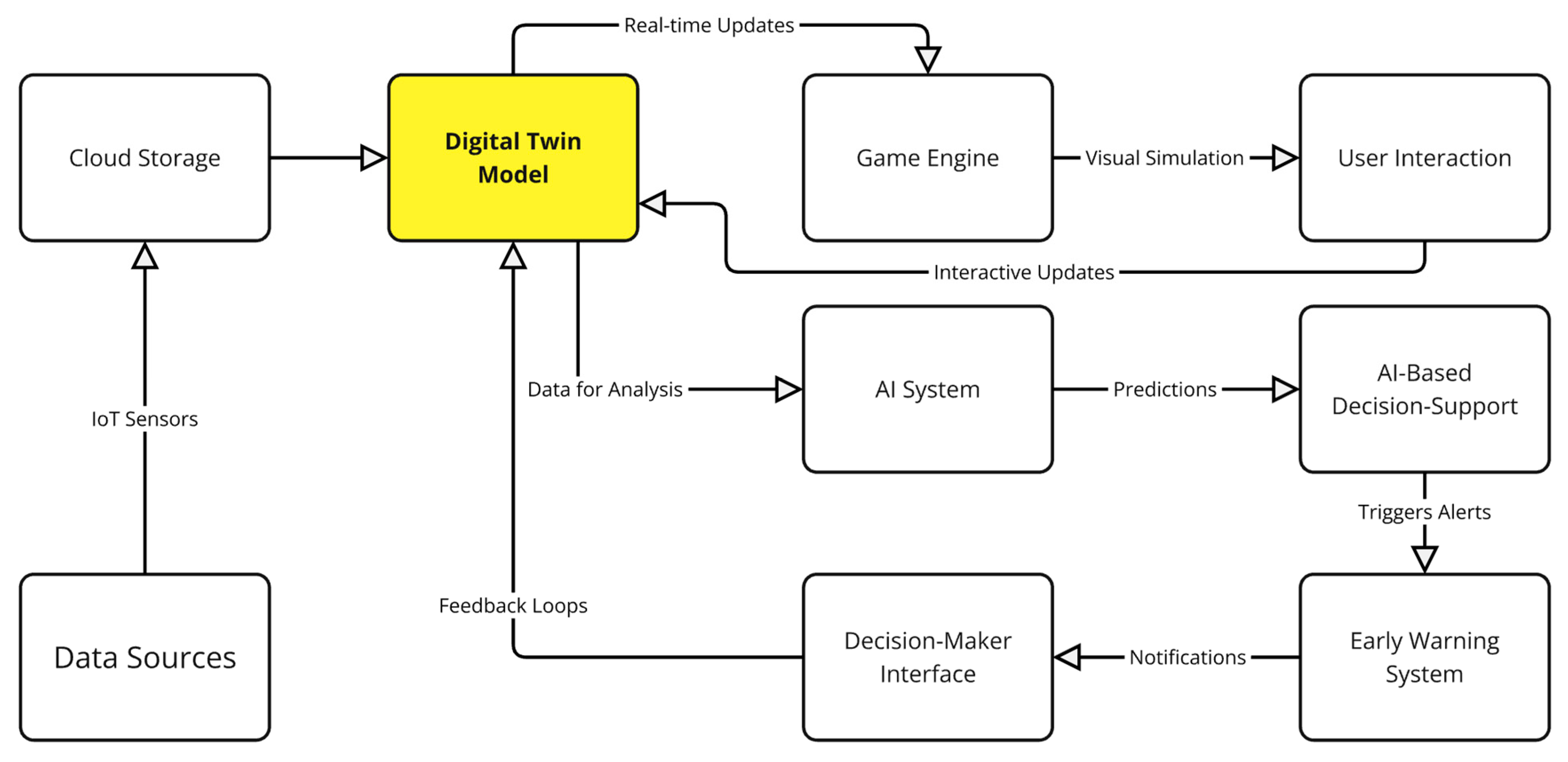
2.2. Digital Twin Model Construction
- Real-Time Sensor Data Collection, Satellite Imagery, and Meteorological Data Integration
- Three-dimensional Visualization and Game Engine Integration
- Hydrological Model Integration
- Predictive Modeling and Scenario Analysis
- Continuous Data Updates and Simulation Refinement
- Stakeholder Interaction and Decision-Making Interface
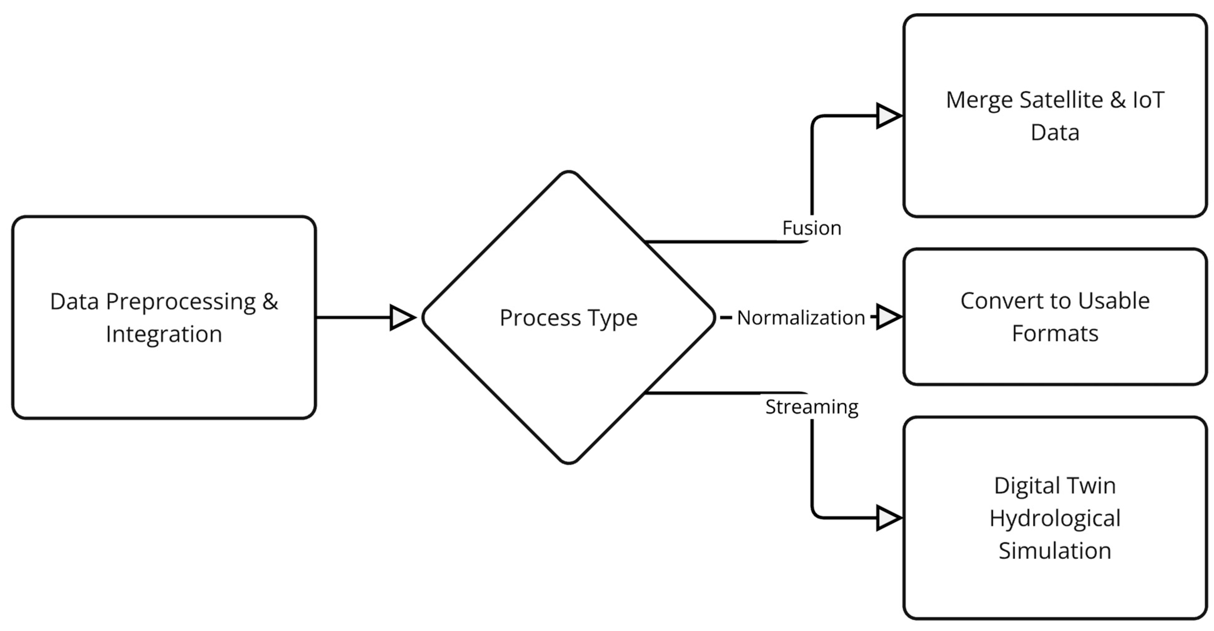
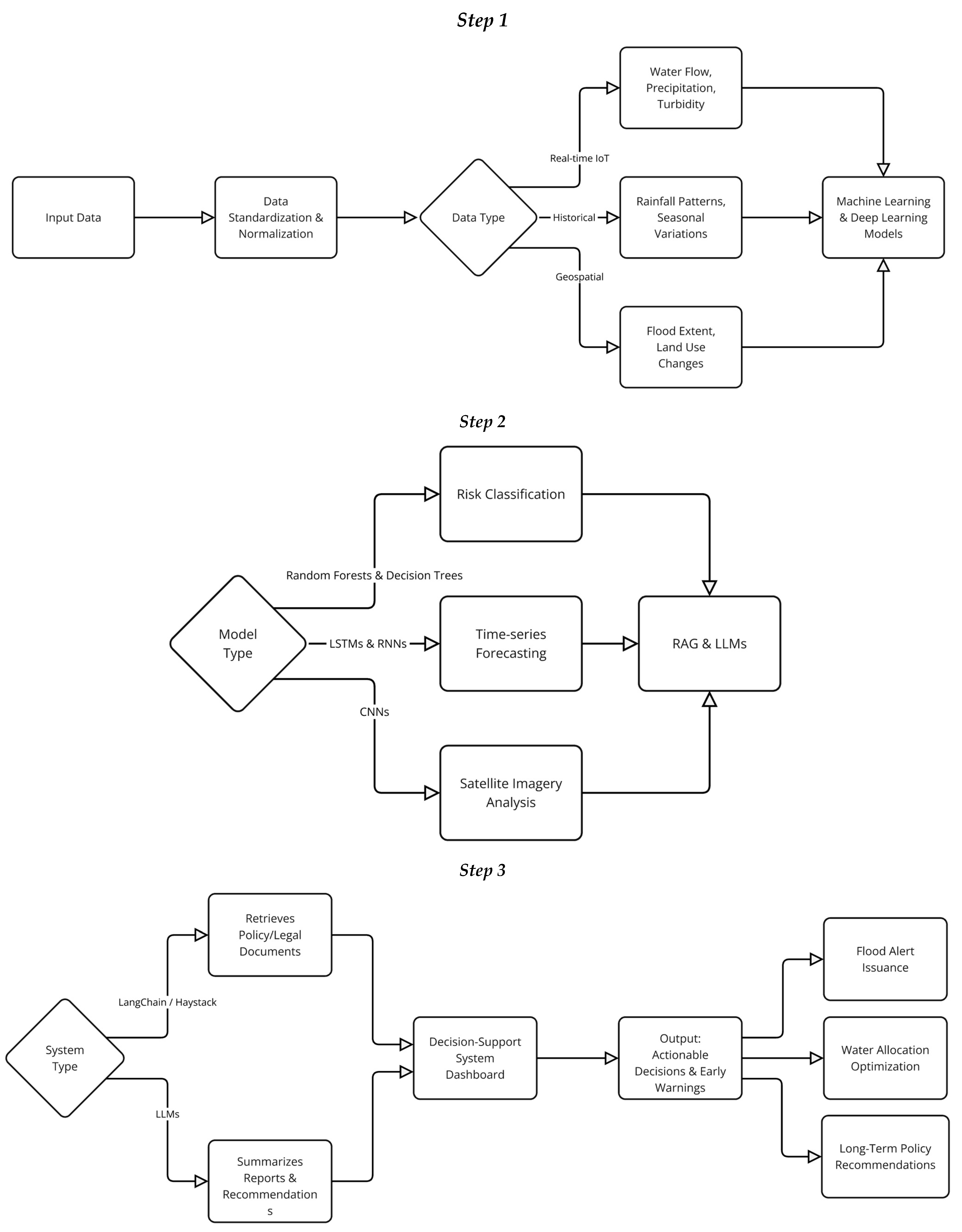
2.3. Data Collection and Integration
2.3.1. Data Sources
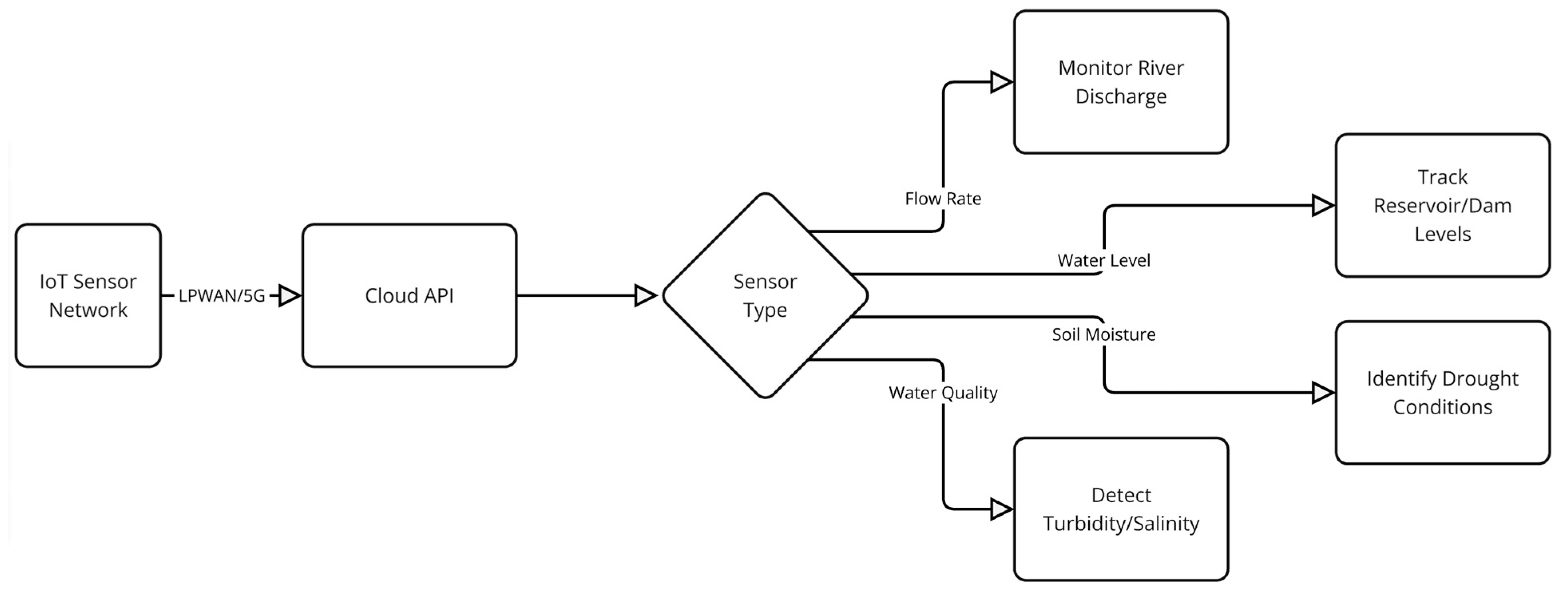
- IoT Sensors: Real-time data from water systems is gathered through a network of IoT sensors strategically placed across critical points of the water reserves. These sensors measure various parameters integral to water management, including:
- Water levels are measured using ultrasonic and radar-based sensors to monitor the height of water in reservoirs, rivers, and dams.
- Flow rates are monitored using electromagnetic flow meters or ultrasonic Doppler flow sensors, ensuring accurate data on the movement and distribution of water.
- Water quality is assessed through sensors that track parameters such as pH, turbidity, dissolved oxygen, and conductivity. These sensors rely on technologies like optical sensors and ion-selective electrodes.
- Temperature data are collected using RTD (resistance temperature detectors) or thermocouples, helping to monitor thermal variations within water bodies.
- 2.
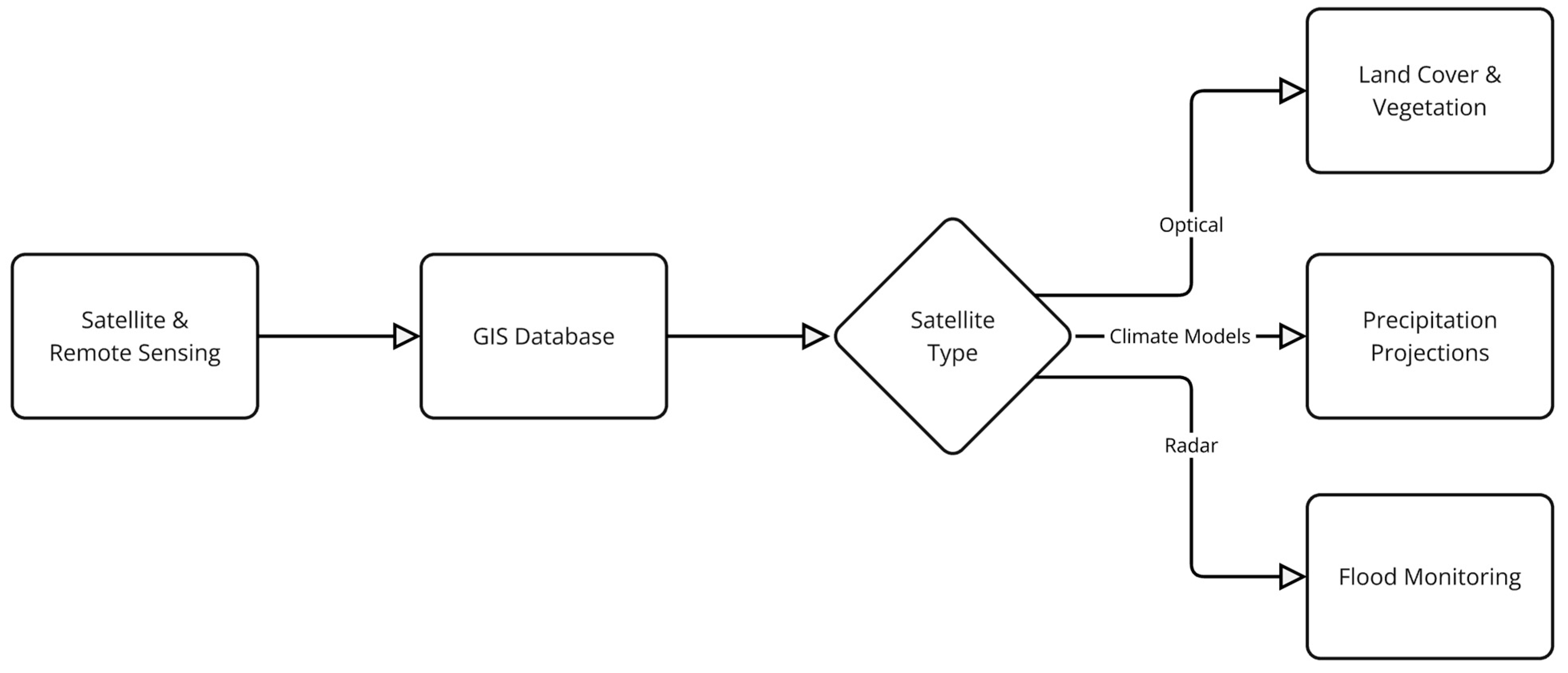
- Satellite Imagery: In addition to ground-based sensors, satellite imagery plays a pivotal role in obtaining large-scale spatial data for monitoring land cover, water body changes, vegetation health, and soil moisture [49,50]. Two primary types of satellite imagery are utilized:
- Optical Satellites like Sentinel-2 provide high-resolution imagery (ranging from 10 to 60 m) and are valuable for observing vegetation and water surface changes. The Copernicus Sentinel-2 mission offers a revisit cycle of 5 days, ensuring frequent monitoring of regions of interest.
- Radar Satellites such as Sentinel-1 are employed to monitor hydrological processes such as flooding, water levels, and soil moisture. These satellites utilize Synthetic Aperture Radar (SAR) technology, which operates regardless of weather conditions or time of day. The ability to collect radar data under all weather conditions makes it ideal for flood and drought monitoring.
- 3.
- Meteorological Data: To complement water-related data, meteorological data from local weather stations and global sources (e.g., NOAA and ECMWF) are also integrated into the framework. These data include:
- Precipitation levels
- Temperature
- Wind speed and direction
- Relative humidity
- 4.
- Other Monitoring Technologies: In addition to sensors and satellites, other technologies, such as drones and ground-based monitoring stations, are used for specific tasks, such as capturing high-resolution images of reservoirs, performing terrain mapping, and monitoring groundwater levels. Drones are particularly valuable for rapid response monitoring and can be deployed quickly to areas that are difficult to access by traditional methods.
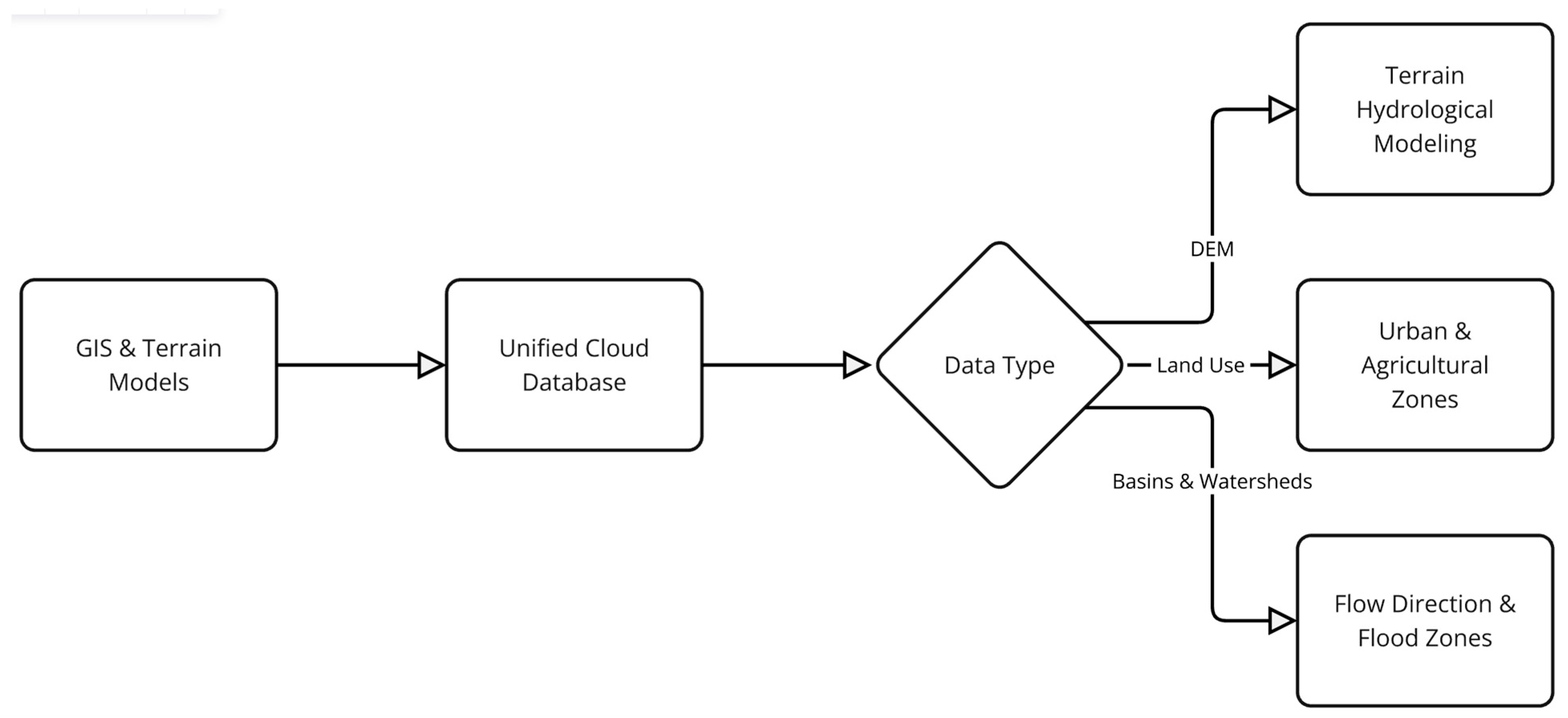
2.3.2. Integration of Geospatial Data
- High-Resolution Digital Elevation Models (DEMs)
- Drones (UAVs): Drones are a valuable tool for creating high-resolution DEMs, especially in large, remote, or difficult-to-access areas. Equipped with LiDAR (Light Detection and Ranging) sensors or RGB cameras, drones can capture extremely detailed elevation data over vast areas with high accuracy. LiDAR technology, in particular, allows for the generation of point clouds, which are used to create precise 3D models of the landscape. The ability to fly low over the terrain ensures that even intricate topographic features, such as riverbanks, cliffs, and small water bodies, are captured in great detail. For large-scale areas, drones provide an efficient means of covering extensive regions while maintaining high resolution.
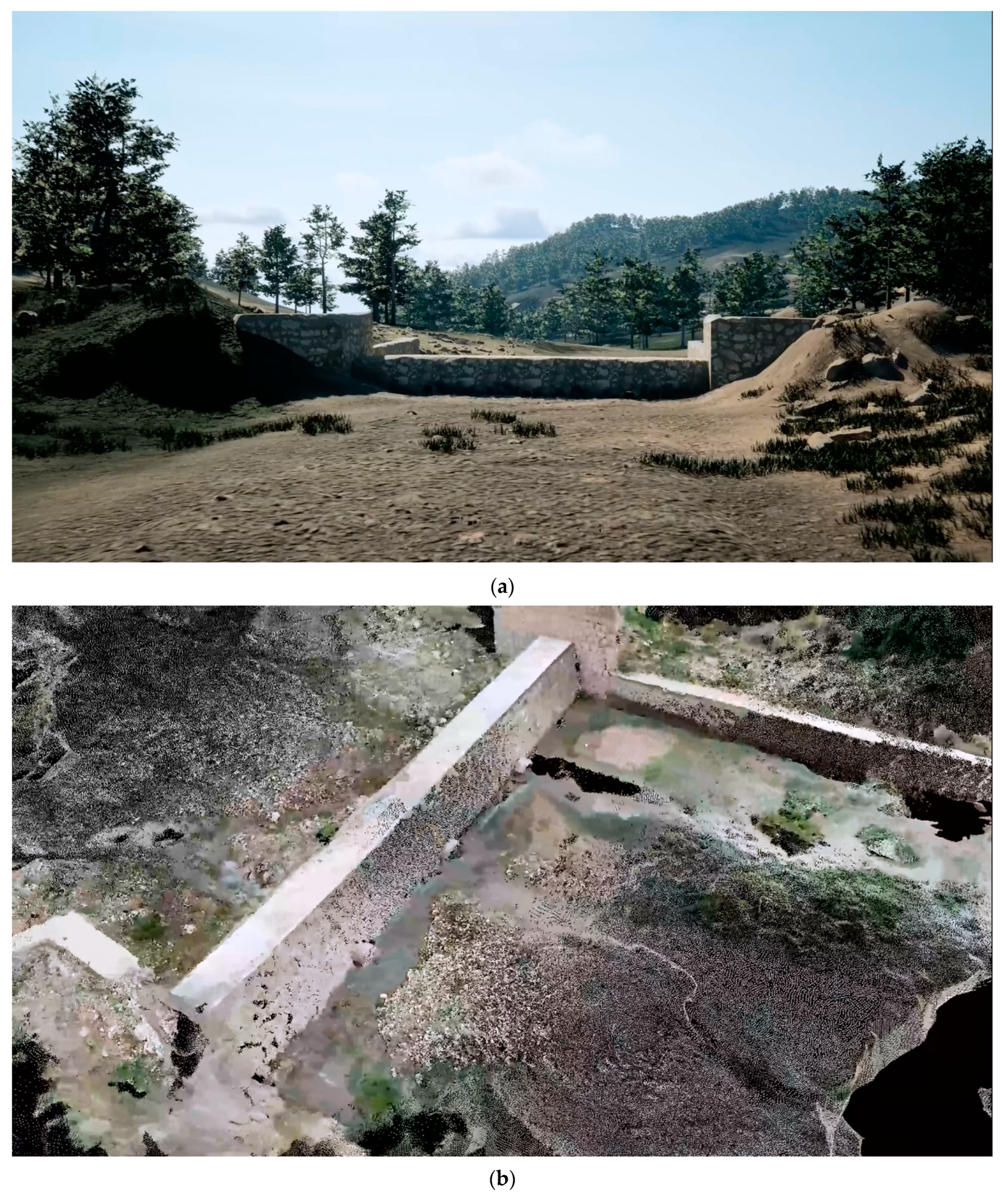
- Close-Range Photogrammetry: For more localized or small-scale elevation modeling, close-range photogrammetry offers another method for generating detailed DEMs. This technique involves capturing a series of overlapping images of the terrain from various angles, which are then processed through specialized software to create accurate 3D models. This method is particularly useful for generating fine-scale DEMs of specific features such as dams, embankments, or reservoirs. Structure-from-Motion (SfM) algorithms are commonly used in photogrammetry to reconstruct 3D surfaces from 2D images.
- Augmented DEM Refinement: To further enhance the resolution and detail of DEMs, particularly in areas that require fine-level adjustments (such as urban environments, water features, or intricate topographic structures), techniques like 3D Gaussian splatting, LiDAR Point Cloud Processing (Surface Reconstruction) using Poisson Surface Reconstruction or Alpha Shapes algorithms, Multi-View Stereo (MVS) Reconstruction using Semi-Global Matching (SGM) or PatchMatch Stereo methods, Volumetric Terrain Modeling using Octree-based voxelization techniques, Deep-Learning-based Surface Reconstruction techniques such as Convolutional Neural Networks (CNNs) or DeepLiDAR, Super-Resolution Algorithms such as Sparse Coding and Photogrammetric Dense Matching (e.g., Hierarchical Matching or Graph-Cuts) and Hybrid Point Cloud Processing can be applied. This method involves refining occlusions and gaps in the point cloud data by applying statistical models to the raw elevation data, effectively filling in missing or unclear areas. It also enhances the precision of DEMs, particularly in regions with dense vegetation or infrastructure, where traditional methods may struggle. This refinement process ensures that the resulting DEM is not only highly detailed but also accurate, providing the best possible representation of the terrain.
- 2.
- Land Use and Soil Types
- 3.
- Real-Time Water Flow Data
2.3.3. Use of Existing Data Repositories
- Hydrological Datasets: Data from Global Runoff Data Centre (GRDC), USGS National Water Information System (NWIS), and other regional hydrological monitoring systems are used to gather historical flow data, river discharge levels, and water storage data. These data support long-term trend analysis and improve the predictive capabilities of the model.
- Climate Projections: Future climate projections from sources such as the IPCC (Intergovernmental Panel on Climate Change) or CMIP (Coupled Model Intercomparison Project) provide insights into potential shifts in weather patterns that could impact water resources. These projections are integrated into the system to simulate future water availability and help plan for potential droughts or extreme weather events.
2.3.4. Specific Tools and Platforms for Data Aggregation and Integration
- MQTT Protocol: The MQTT protocol is widely used for transmitting IoT sensor data to central systems due to its lightweight, low-bandwidth, and low-latency characteristics. It is particularly suitable for IoT networks in water reserves, where devices are often spread across large areas and require reliable, real-time data transmission.
- Geographic Information Systems (GIS): GIS platforms such as ArcGIS and QGIS are critical for integrating, analyzing, and visualizing geospatial data [51]. These systems allow for the creation of accurate digital elevation models, land-use maps, and other spatial data products that are necessary for water flow simulation and management. GIS tools also allow for the visualization of satellite imagery and the overlay of real-time sensor data on maps.
- Cloud-based Data Warehouses: Scalable cloud storage solutions like AWS Redshift, Google BigQuery, and Microsoft Azure are employed to store large amounts of data from various sources, including sensors, satellite imagery, and hydrological datasets. These platforms provide the infrastructure needed for real-time data processing, querying, and integration with the digital twin model.
- Data Integration Platforms: Platforms such as Apache Kafka and Apache NiFi are used to ensure smooth data flow between various data sources and the central database. These tools allow for real-time streaming of data, as well as the processing and integration of large datasets from IoT devices, satellites, and external repositories.
2.4. Model Design and Simulation Environment
- Physical Models Integration: Hydrological models and water balance equations are incorporated into the digital twin framework to simulate water distribution, quality, and behavior under various conditions. These models are calibrated and validated using historical data, real-time sensor readings, and satellite observations.
- Real-Time Data Integration: The digital twin is continuously updated with real-time data collected through IoT sensors, satellite imagery, and weather stations. This allows for dynamic and accurate simulations, which can adapt to changing environmental conditions or management decisions in real time.
- Real-Time Data Updates: The digital twin continuously updates in response to new data, enabling up-to-date simulations of water systems.
- Predictive Modeling: The model includes predictive algorithms that can forecast future water system behaviors based on historical trends, climate projections, and real-time inputs. This is crucial for preparing for extreme weather events like floods or droughts.
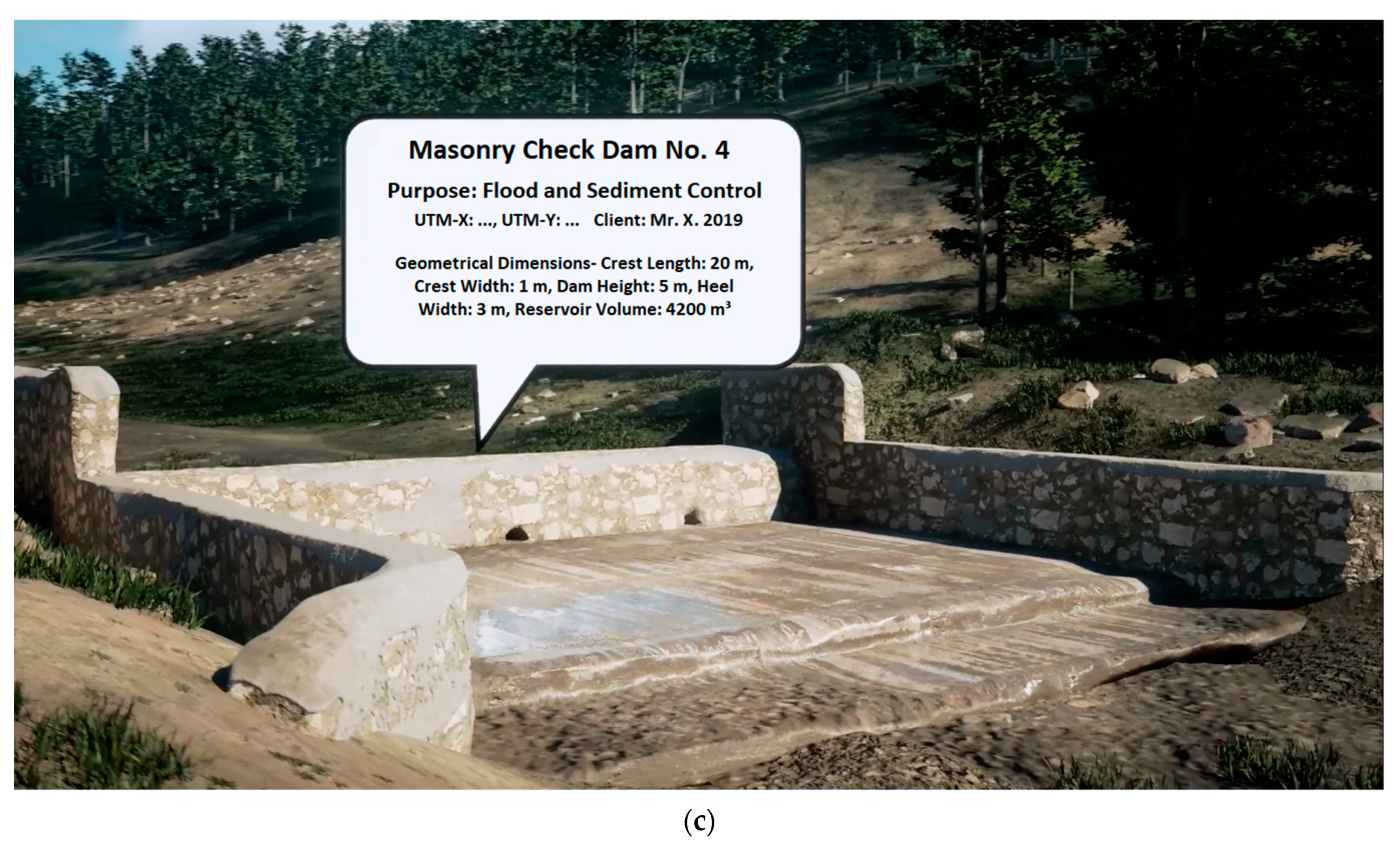
- Scenario Analysis: Users can test different scenarios within the digital twin, such as the impact of a new dam, the effects of climate change on water reserves, or the potential for flooding during heavy rainfall. These simulations help stakeholders visualize the consequences of their decisions before implementing them in the real world.
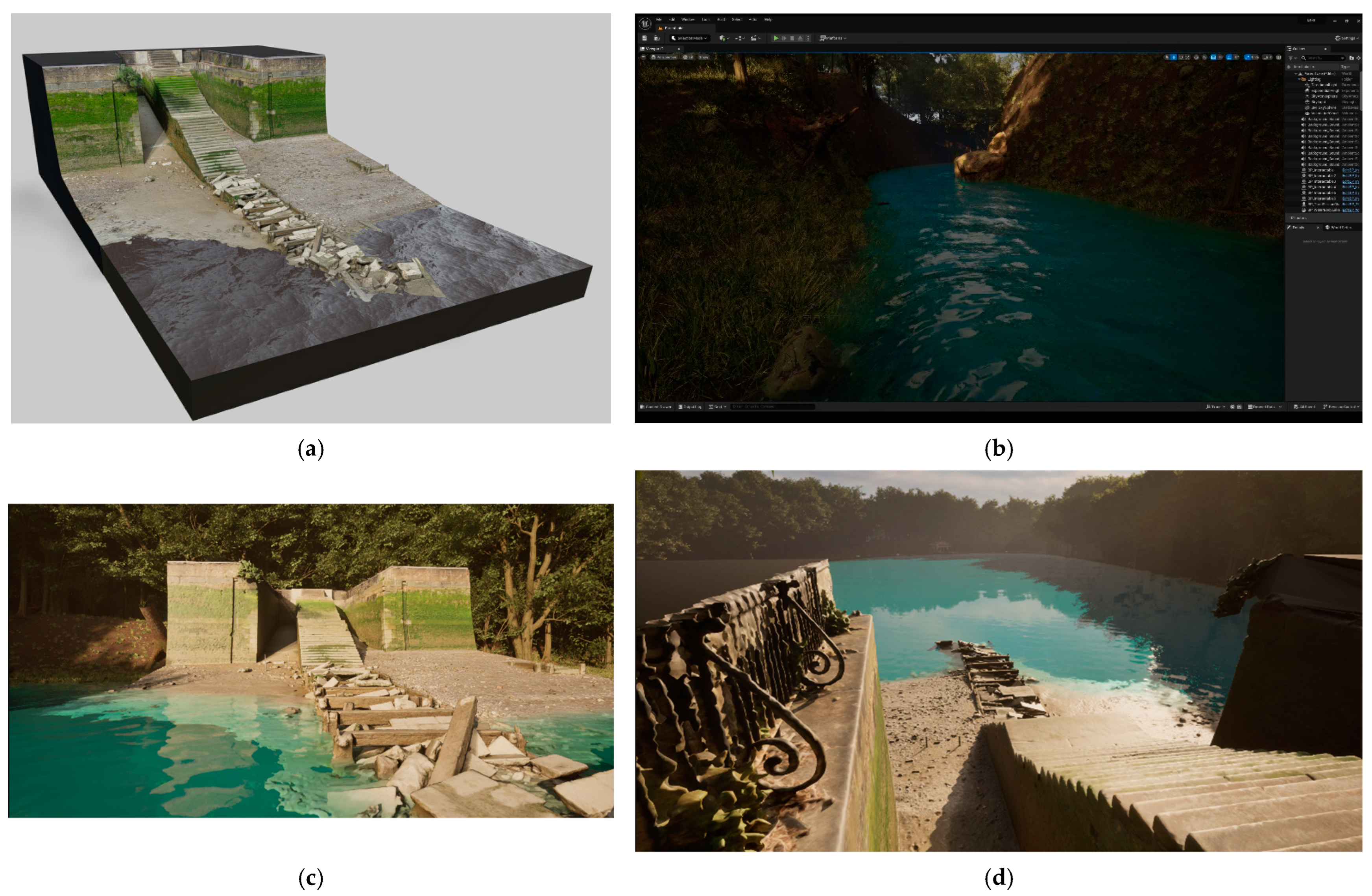
2.5. Game Engine Integration and Simulation Design
- Water System Visualization: Realistic 3D renderings of water bodies, infrastructure (dams, reservoirs), and surrounding terrain.
- Real-Time Interaction: Users can change parameters such as rainfall levels, water demand, or flood mitigation measures and immediately see the resulting changes in water flow and management dynamics.
- Virtual Tour: Utilizing game engines for immersive digital twins is crucial for conducting virtual tours and providing a realistic water reserve management experience, as it allows policymakers and water managers to visualize and interact with hydrological data, flood scenarios, and reservoir dynamics in a highly engaging and informative manner.
- Simulating Various Water Management Scenarios: Visualizations include natural disaster scenarios like floods, droughts, rainfall-induced landslides, water conservation strategies, or infrastructure changes, allowing users to simulate and analyze different management approaches.
2.6. Evaluation Metrics and System Validation
3. Results and Discussion
3.1. Implementation of a Digital Twin-Driven Early Warning System
3.1.1. Flood and Drought Predictions
3.1.2. Water Quality Monitoring and Disaster Preparedness
3.1.3. Real-Time Decision Support and Risk Communication
3.1.4. Empirical Foundations, Research Gaps, and Framework Integration
3.2. Where Data Meets Decisions: AI-Driven Decision Nexus as the Ultimate Solution
3.2.1. Design of an AI-Driven System for Enhanced Water Management Decisions
3.2.2. Integration of Machine-Learning and Deep-Learning Algorithms
3.2.3. Adaptive Decision-Making for Dynamic Recommendations
3.2.4. Use of Open-Source Large Language Models (LLMs)
3.2.5. Developing Retrieval-Augmented Generation (RAG) Chatbots
- A 2012 flood study that analyzed groundwater depletion after extreme rainfall.
- A hydrological model report discussing aquifer recharge patterns post-flood.
- A research paper on soil-infiltration rates during high-precipitation events.
3.3. Implications for Water Reserves Management and Policy
3.3.1. Transforming Water Reserves Management Through Digital Twins and Game Engines
3.3.2. Enhancing Flood Control Strategies and Disaster Response
3.3.3. Advancing Long-Term Water Conservation and Sustainability Policies
3.3.4. Integration with Smart Water Grids and Climate Models
3.3.5. Policy Recommendations and Implementation Challenges at Institutional Level
- Data Standardization and Interoperability: Water management agencies must establish standardized data formats and integration protocols to ensure seamless communication between digital twins, smart grids, and climate models.
- Investment in Digital Infrastructure: The deployment of IoT sensors, high-performance computing, and game engine-based simulations necessitates substantial investments in digital infrastructure and technical expertise.
- Regulatory and Institutional Adaptation: Existing water governance frameworks must be updated to incorporate digital twin-based decision-making, ensuring that insights from real-time simulations inform policy development.
- Stakeholder Engagement and Capacity Building: Training programs for policymakers, water managers, and emergency responders should be established to enhance the practical application of digital twin technologies.
- Cybersecurity and Data Privacy: As water management systems become increasingly digitalized, robust cybersecurity measures must be implemented to safeguard sensitive data and prevent cyber threats.
3.4. Real-World Applications of Digital Twins in Water Management
3.5. Framework Implementation Demonstrations and Prototype Applications
3.6. Roadmap for Pilot Implementation, Deployment Challenges, and Mitigation Solutions
- To address data heterogeneity and interoperability—the challenge of merging datasets from various sources and formats—the framework should prioritize the use of open-data standards such as GeoJSON for spatial vector data and NetCDF for gridded scientific data. These formats enable easier communication between systems and promote long-term compatibility. Additionally, adopting middleware solutions—software layers that act as translators between different data systems—can facilitate real-time synchronization between older, often static legacy datasets (e.g., institutional records, archival GIS layers) and high-frequency IoT-based sensor streams that provide continuous environmental measurements. A preliminary data audit is essential to identify inconsistencies, standardize schemas, and harmonize time-series formats, ensuring that all components feed into the digital twin seamlessly.
- To manage the computational demands of model calibration and AI algorithm retraining, the use of a hybrid infrastructure is recommended. In such a setup, edge devices (compact computing units installed near sensors or data sources) perform low-latency inference tasks—such as detecting anomalies or issuing alerts—while more complex, data-intensive operations such as periodic model retraining are handled in the cloud, where computing resources are virtually unlimited. The framework’s efficiency can further be enhanced by applying transfer-learning techniques, which allow pre-trained models to be fine-tuned for specific tasks with relatively small datasets, and by designing modular AI model updates that isolate components needing revision without affecting the entire pipeline.
- To enhance transparency and stakeholder trust during deployment, the system will integrate explainable AI (XAI) tools such as SHAP and LIME to clarify the contribution of each input variable to the model’s output. These explanations will be visualized through intuitive user interface elements such as annotated graphs or heatmaps. Coupled with uncertainty quantification (e.g., confidence intervals, probabilistic thresholds), these tools will help operational staff and decision-makers interpret forecasts and make informed, accountable decisions.
- Lastly, ensuring the cybersecurity and privacy of real-time data systems is vital, particularly when dealing with critical infrastructure. This requires the adoption of secure communication protocols such as TLS (Transport Layer Security) or SSL (Secure Sockets Layer) to encrypt data in transit and prevent interception. Implementing fine-grained user access control—defining who can view, modify, or manage different system components—is also essential to protect sensitive layers of information. In parallel, the system should apply data-anonymization techniques, especially for geospatial metadata that might reveal the exact locations of infrastructure or water assets, reducing the risk of surveillance, tampering, or misuse.
3.7. Feasibility Assessment of the Proposed Framework
3.7.1. Data Collection and Communication Protocols
3.7.2. Data Integration and Preprocessing Tools
3.7.3. Game Engine Integration and Environmental Fusion
3.7.4. AI-DSS, Chatbot Interaction, and Text-Based Scenarios
3.7.5. Use-Case Scenarios and Translation to Real-World Decision-Making
- Sensor-to-engine integration via MQTT, Apache NiFi, Open3D, or RESTful APIs
- Simulation and terrain modeling via Unreal Engine with plugins like Cesium, Fluid Flux, and Chaos
- AI integration using TensorFlow, PyTorch, and ONNX models embedded via Python APIs or DLLs
- Decision support interactions facilitated through chatbots, voice interfaces, and gamified role-play using Metahumans
3.8. Future Directions and Research Opportunities
3.8.1. Expanding Digital Twin Applications in Environmental and Infrastructure Management
3.8.2. Enhancing Predictive Capabilities and Data Integration
3.8.3. Bridging the Gap Between Research and Implementation
- Standardizing data-exchange protocols across different digital twin platforms to ensure seamless communication.
- Developing AI models capable of handling cross-sectoral interactions, balancing environmental sustainability with economic and social priorities.
- Ensuring cybersecurity and data privacy, as an interconnected system could be vulnerable to malicious attacks or misinformation.
3.8.4. The Utopia of a Fully Interconnected Digital Twin Ecosystem
3.8.5. From Utopia to Dystopia: Risks and Challenges of a Hyper-Connected Digital Twin Network in Water Management
4. Conclusions
- Prototype Implementation: Several core modules—including terrain modeling, scenario simulation, and stakeholder interface—have been implemented and tested in real spatial environments, validating system feasibility.
- Data-Driven Hydrological Monitoring: Real-time IoT data, satellite remote sensing, and GIS inputs enable continuous observation of floods, droughts, and water quality.
- AI Integration with Model Interpretability: Predictive components rely on LSTM, Random Forests, and CNNs, with built-in interpretability via SHAP, LIME, and uncertainty quantification, ensuring transparent and justifiable decision-making.
- Game Engine-Enabled Immersive Planning: Unreal Engine-based environments allow scenario testing for water management interventions, including dam construction, land-use shifts, or emergency response.
- Stakeholder-Centered Decision Interface: Open-source LLMs and retrieval-augmented agents enable interactive querying, translation of complex forecasts, and dynamic feedback loops for participatory governance.
- Security and Ethics by Design: The framework incorporates decentralized governance, explainable AI, privacy-preserving data handling, and hybrid human–AI decision layers to reduce systemic risks.
- Sustainability Alignment: The system promotes equitable access to water insights, empowers adaptive management under climate variability, and supports long-term resilience planning across ecological, economic, and social dimensions.
Author Contributions
Funding
Institutional Review Board Statement
Informed Consent Statement
Data Availability Statement
Conflicts of Interest
References
- Loucks, D.P.; Van Beek, E. Water Resource Systems Planning and Management: An Introduction to Methods, Models, and Applications; Springer: Cham, Switzerland, 2017; pp. 1–624. [Google Scholar]
- Postel, S.L.; Daily, G.C.; Ehrlich, P.R. Human appropriation of renewable fresh water. Science 1996, 271, 785–788. [Google Scholar] [CrossRef]
- Falkenmark, M.; Rockström, J. The new blue and green water paradigm: Breaking new ground for water resources planning and management. J. Water Resour. Plan. Manag. 2006, 132, 129–132. [Google Scholar] [CrossRef]
- Scanlon, B.R.; Faunt, C.C.; Longuevergne, L.; Reedy, R.C.; Alley, W.M.; McGuire, V.L.; McMahon, P.B. Groundwater depletion and sustainability of irrigation in the U.S. High Plains and Central Valley. Proc. Natl. Acad. Sci. USA 2012, 109, 9320–9325. [Google Scholar] [CrossRef] [PubMed]
- Milly, P.C.; Betancourt, J.; Falkenmark, M.; Hirsch, R.M.; Kundzewicz, Z.W.; Lettenmaier, D.P.; Stouffer, R.J. Stationarity is dead: Whither water management? Science 2008, 319, 573–574. [Google Scholar] [CrossRef]
- Vörösmarty, C.J.; Green, P.; Salisbury, J.; Lammers, R.B. Global water resources: Vulnerability from climate change and population growth. Science 2000, 289, 284–288. [Google Scholar] [CrossRef]
- Gleick, P.H. Global freshwater resources: Soft-path solutions for the 21st century. Science 2003, 302, 1524–1528. [Google Scholar] [CrossRef]
- Alley, W.M.; Leake, S.A. The journey from safe yield to sustainability. Groundwater 2004, 42, 12–16. [Google Scholar] [CrossRef]
- Pahl-Wostl, C. Transitions towards adaptive management of water facing climate and global change. Water Resour. Manag. 2007, 21, 49–62. [Google Scholar] [CrossRef]
- Kundzewicz, Z.W.; Mata, L.J.; Arnell, N.W.; Döll, P.; Kabat, P.; Jiménez, B.; Shiklomanov, I.A. Freshwater resources and their management. In Climate Change 2007: Impacts, Adaptation and Vulnerability; Parry, M.L., Canziani, O.F., Palutikof, J.P., van der Linden, P.J., Hanson, C.E., Eds.; Cambridge University Press: Cambridge, UK, 2007; pp. 173–210. [Google Scholar]
- Sene, K. Hydrometeorology: Forecasting and Applications; Springer: Cham, Switzerland, 2010; pp. 1–355. [Google Scholar]
- Montanari, A.; Young, G.; Savenije, H.H.G.; Hughes, D.; Wagener, T.; Ren, L.L.; Cudennec, C. “Panta Rhei—Everything flows”: Change in hydrology and society—The IAHS Scientific Decade 2013–2022. Hydrol. Sci. J. 2013, 58, 1256–1275. [Google Scholar] [CrossRef]
- Apte, P.P.; Spanos, C.J. How human-informed AI leads to more accurate digital twins. MIT Sloan Manag. Rev. (Online) 2024, 1, 1–4. [Google Scholar]
- Grieves, M.; Vickers, J. Digital twin: Mitigating unpredictable, undesirable emergent behavior in complex systems. In Transdisciplinary Perspectives on Complex Systems; Heuveline, F.J., Ed.; Springer: Cham, Switzerland, 2017; pp. 85–113. [Google Scholar]
- Alnaser, A.A.; Maxi, M.; Elmousalami, H. AI-Powered Digital Twins and Internet of Things for Smart Cities and Sustainable Building Environment. Appl. Sci. 2024, 14, 12056. [Google Scholar] [CrossRef]
- Ametefe, D.S.; Hussin, N.; Dah, J.B.; Ali, Z.A. Revolutionising agriculture for food security and environmental sustainability: A perspective on the role of digital twin technology. J. Agric. Inform. 2024, 15, 45–60. [Google Scholar] [CrossRef]
- Li, W. Digital Twins in Agriculture: A Review of Recent Progress and Open Issues. Comput. Electron. Agric. 2024, 199, 107094. [Google Scholar]
- Tao, F.; Zhang, M.; Liu, Y.; Nee, A.Y.C. Digital twin driven prognostics and health management for complex equipment. CIRP Ann. 2018, 67, 169–172. [Google Scholar] [CrossRef]
- Kritzinger, W.; Karner, M.; Traar, G.; Henjes, J.; Sihn, W. Digital twin in manufacturing: A categorical literature review and classification. IFAC-Pap. Online 2018, 51, 1016–1022. [Google Scholar] [CrossRef]
- Qi, Q.; Tao, F.; Hu, T.; Anwer, N.; Liu, A.; Wei, Y.; Nee, A.Y.C. Enabling technologies and tools for digital twin. J. Manuf. Syst. 2021, 58, 3–21. [Google Scholar] [CrossRef]
- Jones, D.; Snider, C.; Nassehi, A.; Yon, J.; Hicks, B. Characterising the Digital Twin: A Systematic Literature Review. CIRP J. Manuf. Sci. Technol. 2020, 29, 36–52. [Google Scholar] [CrossRef]
- Conejos Fuertes, P.; Martínez Alzamora, F.; Hervás Carot, M.; Alonso Campos, J.C. Building and Exploiting a Digital Twin for the Management of Drinking Water Distribution Networks. Urban Water J. 2020, 17, 704–713. [Google Scholar] [CrossRef]
- Ramos, H.M.; Morani, M.C.; Carravetta, A.; Fecarrotta, O.; Adeyeye, K.; López-Jiménez, P.A.; Pérez-Sánchez, M. New Challenges towards Smart Systems’ Efficiency by Digital Twin in Water Distribution Networks. Water 2022, 14, 1304. [Google Scholar] [CrossRef]
- Boulos, M.N.K.; Al-Shorbaji, N.M. On the Internet of Things, Smart Cities and the WHO Healthy Cities. Int. J. Health Geogr. 2014, 13, 10. [Google Scholar] [CrossRef]
- Purcell, W.; Neubauer, T. Digital Twins in Agriculture: A State-of-the-Art Review. Smart Agric. Technol. 2023, 3, 100094. [Google Scholar] [CrossRef]
- Sardar, M.A.; Amir, E.; Rehman, M.A.; Malik, K.F.; Khalid, M.A. Integration of Digital Twin Technology for Water Resource Management of Smart Cities and Communities: A Narrative Review. Int. J. Adv. Nat. Sci. Eng. Res. 2025, 9, 75–85. [Google Scholar]
- Li, W.; Ma, Z.; Li, J.; Li, Q.; Li, Y.; Yang, J. Digital Twin Smart Water Conservancy: Status, Challenges, and Prospects. Water 2024, 16, 2038. [Google Scholar] [CrossRef]
- Sivapalan, M.; Takeuchi, K.; Franks, S.W.; Gupta, V.K.; Karambiri, H.; Lakshmi, V.; Zehe, E. IAHS Decade on Predictions in Ungauged Basins (PUB), 2003–2012: Shaping an Exciting Future for the Hydrological Sciences. Hydrol. Sci. J. 2003, 48, 857–880. [Google Scholar] [CrossRef]
- Wagener, T.; Sivapalan, M.; Troch, P.A.; Woods, R.A. Catchment Classification and Hydrologic Similarity. Geogr. Compass 2007, 1, 901–931. [Google Scholar] [CrossRef]
- Blöschl, G.; Bierkens, M.F.P.; Chambel, A.; Cudennec, C.; Destouni, G.; Fiori, A.; Zehe, E. Twenty-Three Unsolved Problems in Hydrology (UPH)–A Community Perspective. Hydrol. Sci. J. 2019, 64, 1141–1158. [Google Scholar] [CrossRef]
- Kang, W.; Jang, E.K. Reproducing Water Flow Using 3D Game Engine. In Proceedings of the Korea Water Resources Association Conference; Korea Water Resources Association: Seoul, Republic of Korea, 2023; p. 432. [Google Scholar]
- Khoury, M.; Evans, B.; Chen, O.; Chen, A.S.; Vamvakeridou-Lyroudia, L.; Savic, D.A.; Mustafee, N. NEXTGEN: A Serious Game Showcasing Circular Economy in the Urban Water Cycle. J. Clean. Prod. 2023, 391, 136000. [Google Scholar] [CrossRef]
- Mat, R.C.; Shariff, A.R.M.; Zulkifli, A.N.; Rahim, M.S.M.; Mahayudin, M.H. Using Game Engine for 3D Terrain Visualisation of GIS Data: A Review. In IOP Conference Series: Earth and Environmental Science; IOP Publishing: Bristol, UK, 2014; Volume 20, p. 012037. [Google Scholar]
- Freiknecht, J.; Geiger, C.; Drochtert, D.; Effelsberg, W.; Dörner, R. Game Engines. In Serious Games: Foundations, Concepts and Practice; Springer: Berlin/Heidelberg, Germany, 2016; pp. 127–159. [Google Scholar]
- Buyuksalih, I.; Bayburt, S.; Buyuksalih, G.; Baskaraca, A.P.; Karim, H.; Rahman, A.A. 3D Modelling and Visualization Based on the Unity Game Engine–Advantages and Challenges. ISPRS Ann. Photogramm. Remote Sens. Spat. Inf. Sci. 2017, 4, 161–166. [Google Scholar] [CrossRef]
- Gregory, J. Game Engine Architecture; AK Peters/CRC Press: Boca Raton, FL, USA, 2018. [Google Scholar]
- Yin, W.; Hu, Q.; Liu, W.; Liu, J.; He, P.; Zhu, D.; Kornejady, A. Harnessing Game Engines and Digital Twins: Advancing Flood Education, Data Visualization, and Interactive Monitoring for Enhanced Hydrological Understanding. Water 2024, 16, 2528. [Google Scholar] [CrossRef]
- Gubbi, J.; Buyya, R.; Marusic, S.; Palaniswami, M. Internet of Things (IoT): A Vision, Architectural Elements, and Future Directions. Futur. Gener. Comput. Syst. 2013, 29, 1645–1660. [Google Scholar] [CrossRef]
- Nash, J.E.; Sutcliffe, J.V. River Flow Forecasting through Conceptual Models Part I—A Discussion of Principles. J. Hydrol. 1970, 10, 282–290. [Google Scholar] [CrossRef]
- Neitsch, S.L.; Arnold, J.G.; Kiniry, J.R.; Williams, J.R. Soil and Water Assessment Tool Theoretical Documentation Version 2009; Texas Water Resources Institute: College Station, TX, USA, 2011. [Google Scholar]
- Verdouw, C.; Tekinerdogan, B.; Beulens, A.; Wolfert, S. Digital Twins in Smart Farming. Agric. Syst. 2021, 189, 103046. [Google Scholar] [CrossRef]
- Manocha, A.; Sood, S.K.; Bhatia, M. IoT-Digital Twin-Inspired Smart Irrigation Approach for Optimal Water Utilization. Sustain. Comput. Inform. Syst. 2023, 41, 100947. [Google Scholar] [CrossRef]
- Smith, J.; Brown, T. Game Engines for Environmental Modeling: A Review. Environ. Model. Softw. 2019, 112, 1–12. [Google Scholar]
- Camacho, E.F.; Bordons, C. Model Predictive Control; Springer: London, UK; New York, NY, USA, 2004. [Google Scholar]
- Beven, K.; Binley, A. The future of distributed models: Model calibration and uncertainty prediction. Hydrol. Process. 1992, 6, 279–298. [Google Scholar] [CrossRef]
- Montanari, A. What do we mean by ‘uncertainty’? The need for a consistent wording about uncertainty assessment in hydrology. Hydrol. Process. 2007, 21, 841–845. [Google Scholar] [CrossRef]
- Renard, B.; Kavetski, D.; Kuczera, G.; Thyer, M.; Franks, S.W. Understanding predictive uncertainty in hydrologic modeling: The challenge of identifying input and structural errors. Water Resour. Res. 2010, 46, W05521. [Google Scholar] [CrossRef]
- Rudin, C. Stop explaining black box machine learning models for high stakes decisions and use interpretable models instead. Nat. Mach. Intell. 2019, 1, 206–215. [Google Scholar] [CrossRef]
- Rodell, M.; Velicogna, I.; Famiglietti, J.S. Satellite-Based Estimates of Groundwater Depletion in India. Nature 2009, 460, 999–1002. [Google Scholar] [CrossRef]
- Masud, M.J.; Bastiaanssen, W.G. Remote Sensing and GIS Applications in Water Resources Management. Water Resour. Manag. 2017, 31, 351–373. [Google Scholar]
- Goodchild, M.F. Twenty Years of Progress: GIScience in 2010. J. Spat. Inf. Sci. 2010, 1, 3–20. [Google Scholar] [CrossRef]
- Mosavi, A.; Ozturk, P.; Chau, K.W. Flood Prediction Using Machine Learning Models: Literature Review. Water 2018, 10, 1536. [Google Scholar] [CrossRef]
- Kumar, S.; Tiwari, P.; Zymbler, M. Internet of Things is a Revolutionary Approach for Future Technology Enhancement: A Review. J. Big Data 2019, 6, 1–21. [Google Scholar] [CrossRef]
- Radford, A.; Wu, J.; Child, R.; Luan, D.; Amodei, D.; Sutskever, I. Language Models are Unsupervised Multitask Learners. OpenAI Blog 2019, 1, 9. [Google Scholar]
- Zulkifli, C.Z.; Garfan, S.; Talal, M.; Alamoodi, A.H.; Alamleh, A.; Ahmaro, I.Y.; Chiang, H.H. IoT-Based Water Monitoring Systems: A Systematic Review. Water 2022, 14, 3621. [Google Scholar] [CrossRef]
- Song, W. Development of a Digital Twin-Based Early Warning System for River Flooding: A Case Study of the Tartano River. Master’s Thesis, Polytechnic University of Milan, Milan, Italy, 2022. [Google Scholar]
- Li, Q. Analysis of the Evaluation and Pre-warning System of the Urban Flood Disaster Based on the Digital Twin Technology. J. Beijing Univ. Technol. 2022, 48, 476–485. [Google Scholar]
- Riaz, K.; McAfee, M.; Gharbia, S.S. Management of climate resilience: Exploring the potential of digital twin technology, 3D city modelling, and early warning systems. Sensors 2023, 23, 2659. [Google Scholar] [CrossRef]
- Thakur, S. Based on Digital Twin Technology, an Early Warning System and Strategy for Predicting Urban Waterlogging. In Simulation Techniques of Digital Twin in Real-Time Applications: Design Modeling and Implementation; Wiley: Hoboken, NJ, USA, 2024; pp. 301–318. [Google Scholar]
- Batarseh, F.A.; Kulkarni, A.; Sreng, C.; Lin, J.; Maksud, S. ACWA: An AI-Driven Cyber-Physical Testbed for Intelligent Water Systems. arXiv 2023, arXiv:2310.17654. [Google Scholar] [CrossRef]
- Syed, T.A.; Khan, M.Y.; Jan, S.; Albouq, S.; Alqahtany, S.S.; Naqash, M.T. Integrating Digital Twins and Artificial Intelligence Multi-Modal Transformers into Water Resource Management: Overview and Advanced Predictive Framework. AI 2024, 5, 1977–2017. [Google Scholar] [CrossRef]
- Zekri, S.; Jabeur, N.; Gharrad, H. Smart Water Management Using Intelligent Digital Twins. Comput. Inform. 2022, 41, 135–153. [Google Scholar] [CrossRef]
- Del-Coco, M.; Leo, M.; Carcagnì, P. Machine Learning for Smart Irrigation in Agriculture: How Far Along Are We? Comput. Electron. Agric. 2024, 198, 107093. [Google Scholar] [CrossRef]
- Chaudhari, S.; Sardar, V.; Rahul, D.S.; Chandan, M.; Shivakale, M.S.; Harini, K.R. Performance analysis of CNN, Alexnet and vggnet models for drought prediction using satellite images. In Proceedings of the 2021 Asian Conference on Innovation in Technology (ASIANCON), Pune, India, 27–29 August 2021; pp. 1–6. [Google Scholar]
- Elbeltagi, A.; Srivastava, A.; Ehsan, M.; Sharma, G.; Yu, J.; Khadke, L.; Jinsong, D. Advanced stacked integration method for forecasting long-term drought severity: CNN with machine learning models. J. Hydrol. Reg. Stud. 2024, 53, 101759. [Google Scholar] [CrossRef]
- Hu, Y.; Yan, L.; Hang, T.; Feng, J. Stream-flow forecasting of small rivers based on LSTM. arXiv 2020, arXiv:2001.05681. [Google Scholar]
- Hunt, K.M.; Matthews, G.R.; Pappenberger, F.; Prudhomme, C. Using a long short-term memory (LSTM) neural network to boost river streamflow forecasts over the western United States. Hydrol. Earth Syst. Sci. 2022, 26, 5449–5472. [Google Scholar] [CrossRef]
- Arsenault, R.; Martel, J.L.; Brunet, F.; Brissette, F.; Mai, J. Continuous streamflow prediction in ungauged basins: Long short-term memory neural networks clearly outperform traditional hydrological models. Hydrol. Earth Syst. Sci. 2023, 27, 139–157. [Google Scholar] [CrossRef]
- Uc-Castillo, J.L.; Marín-Celestino, A.E.; Martínez-Cruz, D.A.; Tuxpan-Vargas, J.; Ramos-Leal, J.A. A systematic review and meta-analysis of groundwater level forecasting with machine learning techniques: Current status and future directions. Environ. Model. Softw. 2023, 168, 105788. [Google Scholar] [CrossRef]
- Wu, R.; Wang, R.; Hao, J.; Wu, Q.; Wang, P. Multiobjective multihydropower reservoir operation optimization with transformer-based deep reinforcement learning. J. Hydrol. 2024, 632, 130904. [Google Scholar] [CrossRef]
- Mohammed, H.; Hameed, I.A.; Seidu, R. Machine learning: Based detection of water contamination in water distribution systems. In Proceedings of the Genetic and Evolutionary Computation Conference Companion, Kyoto, Japan, 15–19 July 2018; pp. 1664–1671. [Google Scholar]
- Ghobadi, F.; Kang, D. Application of machine learning in water resources management: A systematic literature review. Water 2023, 15, 620. [Google Scholar] [CrossRef]
- Yang, C.; Xu, M.; Kang, S.; Fu, C.; Hu, D. Improvement of streamflow simulation by combining physically hydrological model with deep learning methods in data-scarce glacial river basin. J. Hydrol. 2023, 625, 129990. [Google Scholar] [CrossRef]
- Ahmed, A.A.; Sayed, S.; Abdoulhalik, A.; Moutari, S.; Oyedele, L. Applications of machine learning to water resources management: A review of present status and future opportunities. J. Clean. Prod. 2024, 441, 140715. [Google Scholar] [CrossRef]
- Alinejad, A.; Kumar, K.; Vahdat, A. Evaluating the Retrieval Component in LLM-Based Question Answering Systems. arXiv 2024, arXiv:2406.06458. [Google Scholar]
- Prince, M.H.; Chan, H.; Vriza, A.; Zhou, T.; Sastry, V.K.; Luo, Y.; Cherukara, M.J. Opportunities for Retrieval and Tool Augmented Large Language Models in Scientific Facilities. npj Comput. Mater. 2024, 10, 251. [Google Scholar] [CrossRef]
- Akkiraju, R.; Xu, A.; Bora, D.; Yu, T.; An, L.; Seth, V.; Boitano, J. FACTS About Building Retrieval Augmented Generation-Based Chatbots. arXiv 2024, arXiv:2407.07858. [Google Scholar]
- Ramos, H.M.; Kuriqi, A.; Besharat, M.; Creaco, E.; Tasca, E.; Coronado-Hernández, O.E.; Iglesias-Rey, P. Smart Water Grids and Digital Twin for the Management of System Efficiency in Water Distribution Networks. Water 2023, 15, 1129. [Google Scholar] [CrossRef]
- Wu, Z.Y.; Chew, A.; Meng, X.; Cai, J.; Pok, J.; Kalfarisi, R.; Wong, J.J. High-Fidelity Digital Twin-Based Anomaly Detection and Localization for Smart Water Grid Operation Management. Sustain. Cities Soc. 2023, 91, 104446. [Google Scholar] [CrossRef]
- Jafari, M.; Kavousi-Fard, A.; Chen, T.; Karimi, M. A Review on Digital Twin Technology in Smart Grid, Transportation System, and Smart City: Challenges and Future. IEEE Access 2023, 11, 17471–17484. [Google Scholar] [CrossRef]
- Johnson, B. Water reuse and recovery facility connected digital twin case study: Singapore PUB’s Changi WRP process, control, and hydraulics digital twin. In Proceedings of the WEFTEC 2021, Virtual, 16–20 October 2021; Water Environment Federation: Alexandria, VA, USA, 2021. [Google Scholar]
- Hu, D.; Zhou, C.; Xie, F. Application of Digital Twin Technology in Assessing the Level of Water Ecological Civilization Construction in Yangtze River Basin. In Hydraulic Structure and Hydrodynamics; Springer: Singapore, 2024; pp. 343–352. [Google Scholar]
- Xu, Y.; Hui, M.; Qu, H. Design of a 3D Platform for the Evaluation of Water Quality in Urban Rivers Based on a Digital Twin Model. Water 2024, 16, 3668. [Google Scholar] [CrossRef]
- Foroumandi, E.; Moradkhani, H.; Krajewski, W.F.; Ogden, F.L. Ensemble data assimilation for operational streamflow predictions in the next generation (NextGen) framework. Environ. Model. Softw. 2025, 185, 106306. [Google Scholar] [CrossRef]
- Wolters, B.M. Exploring the Potential of Urban Digital Twins in Climate Adaptive Development, A Case Study Research on the Gnephoekpolder, the Netherlands. Master’s Thesis, Wageningen University & Research, Delft University of Technology, AMS Institute SWECO, Delft, The Netherlands, 2023. [Google Scholar]
- Lumley, D.; Jursic Wanninger, D.; Magnusson, Å.; I’Ons, D.; Gustafsson, L.G. Implementing a digital twin for optimized real-time control of Gothenburg’s regional sewage system. Water Pract. Technol. 2024, 19, 657–670. [Google Scholar] [CrossRef]
- Molin, H.; Wärff, C.; Lindblom, E.; Arnell, M.; Carlsson, B.; Mattsson, P.; Jeppsson, U. Automated data transfer for digital twin applications: Two case studies. Water Environ. Res. 2024, 96, e11074. [Google Scholar] [CrossRef]
- Nyirenda, M. Open Waters—Digital Twins With Use of Open Data and Shared Design for Swedish Water Treatment Plants. 2020. Available online: https://www.essays.se/essay/6dc59f3d0b/ (accessed on 10 February 2025).
- Ford, D.N.; Wolf, C.M. Smart cities with digital twin systems for disaster management. J. Manag. Eng. 2020, 36, 04020027. [Google Scholar] [CrossRef]
- Gould, O. Improving the Learning Experience of Decision Support Systems in Entrepreneurship with 3D Management Simulation Games. Ph.D. Thesis, University of Victoria, Victoria, BC, Canada, 2022. [Google Scholar]
- Ellul, C.; Hamilton, N.; Pieri, A.; Floros, G. Exploring Data for Construction Digital Twins: Building Health and Safety and Progress Monitoring Twins Using the Unreal Gaming Engine. Buildings 2024, 14, 2216. [Google Scholar] [CrossRef]
- Jiménez del Castillo, I. Adaptación de ChatBots a Avatares Virtuales con Metahuman: Comunicación de ChatBot con Unreal Engine y Conversión Texto a Voz con API de ReadSpeaker (Adaptation of Chatbots to Virtual Avatars with MetaHuman: Chatbot Communication with Unreal Engine and Text-to-Speech Conversion Using ReadSpeaker API). Bachelor’s Thesis, University of Malaga, Málaga, Spain, 2022. [Google Scholar]
- Mashaly, M. Connecting the Twins: A Review on Digital Twin Technology & Its Networking Requirements. Procedia Comput. Sci. 2021, 184, 299–305. [Google Scholar]
- Ricci, A.; Croatti, A.; Montagna, S. Pervasive and Connected Digital Twins—A Vision for Digital Health. IEEE Internet Comput. 2021, 26, 26–32. [Google Scholar] [CrossRef]
- García, Á.; Bregon, A.; Martínez-Prieto, M.A. Towards a Connected Digital Twin Learning Ecosystem in Manufacturing: Enablers and Challenges. Comput. Ind. Eng. 2022, 171, 108463. [Google Scholar] [CrossRef]
- Infante, S.; Robles, J.; Martín, C.; Rubio, B.; Díaz, M. Distributed Digital Twins on the Open-Source OpenTwins Framework. Adv. Eng. Inform. 2025, 64, 102970. [Google Scholar] [CrossRef]
- Tao, F.; Zhang, H.; Liu, A.; Nee, A.Y.C. Digital Twin in Industry: State-of-the-Art. IEEE Trans. Ind. Inform. 2022, 15, 2405–2415. [Google Scholar] [CrossRef]

| Algorithm Type | Model Type | Strengths | Limitations | Use Case in Water Management | Training Time | Data Requirements |
|---|---|---|---|---|---|---|
| Linear Regression | Supervised Learning | Simple, fast, interpretable | Assumes linear relationships; not suitable for complex patterns | Predicting water demand based on historical data | Short | Low |
| K-Nearest Neighbors (KNN) | Supervised Learning | Simple and intuitive | Computationally expensive for large datasets | Estimating regional water quality | Short | Medium |
| Decision Trees | Supervised Learning | Easy to interpret, good for classification | Can overfit; less accurate with complex data | Classifying flood risk zones | Medium | Medium |
| Random Forest | Supervised Learning | Robust to overfitting, handles large datasets | Computationally expensive | Predicting flood events and water quality | Medium | Medium to High |
| Support Vector Machines (SVM) | Supervised Learning | Effective in high-dimensional spaces | Computationally intensive, requires parameter tuning | Classification of water body conditions | Medium | High |
| Convolutional Neural Networks (CNN) | Deep Learning | Excellent for pattern recognition in images | Requires a large amount of data and computational power | Analyzing satellite imagery for land use changes | Long | High |
| Recurrent Neural Networks (RNN) | Deep Learning | Effective for time-series data | Can suffer from vanishing gradients, requires large datasets | Predicting water flow or rainfall patterns | Long | High |
| Long Short-Term Memory (LSTM) | Deep Learning | Handles long-term dependencies well | Requires significant training data, slow to train | Real-time water level predictions | Long | High |
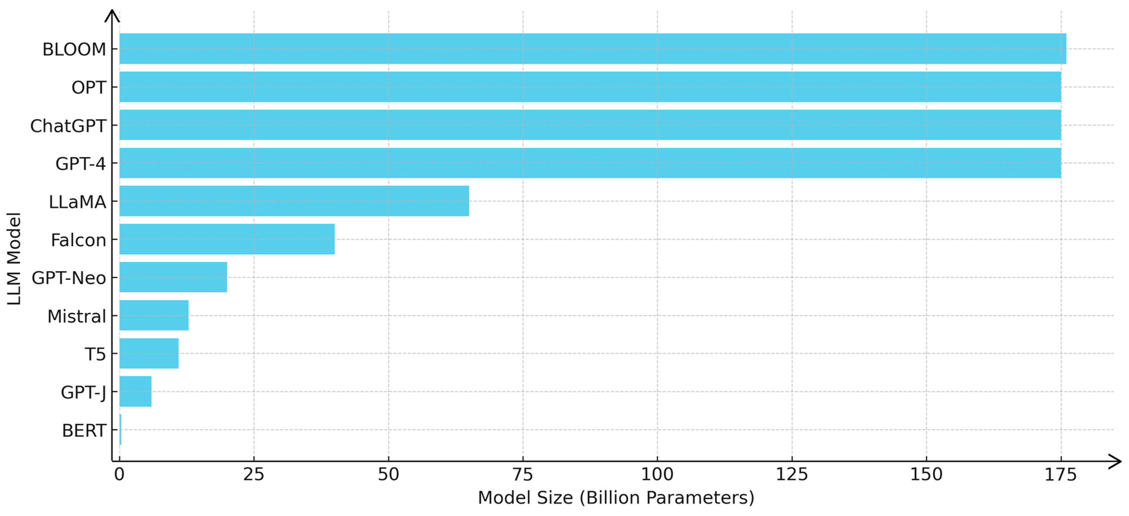
| LLM Model | Developer | Strengths | Limitations | Use Case | Training Time | Open Source | Use Case in Water Management |
|---|---|---|---|---|---|---|---|
| GPT-4 | OpenAI | Strong general language understanding, handles complex queries, computationally expensive and less easily fine-tuned for domain-specific tasks | Computationally expensive, lacks fine-tuned domain-specific knowledge | Conversational AI, text generation, decision support | Long | 🗶 | Conversational insights on water management, predicting water stress |
| BERT | Good at contextual language understanding, pre-trained on large corpora | Requires fine-tuning for specific tasks | NLP tasks, question answering, summarization | Medium | ✓ | Assisting with water reserve documentation, query handling | |
| T5 | Strong in multiple NLP tasks, flexible with fine-tuning | Requires large datasets for training | Text-to-text generation, data extraction | Medium | ✓ | Generating insights and recommendations for water management policies | |
| GPT-4-turbo | OpenAI | Specializes in conversational interfaces, handles long conversations | Limited by the pre-trained knowledge cutoff | Customer service, decision support | Medium | 🗶 | Real-time user queries about flooding or water shortage conditions |
| LLaMA | Meta | Open-source, high performance for specific tasks | Requires fine-tuning for high accuracy | Text generation, summarization | Medium | ✓ | Generating reports or summaries on water system health |
| Falcon | Technology Innovation Institute | State-of-the-art performance with efficient use of resources | Smaller model sizes may not outperform larger models | Text generation, summarization, question answering | Moderate (due to optimizations) | ✓ | Localized water data analysis, simulation predictions, real-time monitoring |
| Mistral | Mistral AI | Efficient training, open architecture, cost-effective | May lack capabilities of larger models for complex tasks | Text generation, dialogue systems, question answering | Faster (optimized for deployment) | ✓ | Quick, accurate predictive insights for water systems, disaster risk assessment |
| GPT-Neo | EleutherAI | Open-source, high performance for various NLP tasks | Smaller model sizes might be less accurate | Text generation, summarization, question answering | Medium | ✓ | Assisting with decision support and system insights |
| GPT-J | EleutherAI | Open-source, strong language understanding for general purposes | Can be computationally demanding for real-time applications | Generating reports, conversational interfaces | Medium | ✓ | Providing on-demand decision insights for water system management |
| BLOOM | BigScience | Open-source, multilingual support, strong cross-lingual capabilities | Computationally expensive, not as fine-tuned for specific domains | Multilingual tasks, summarization, conversation | Long | ✓ | Multilingual flood management communication, cross-region collaboration |
| OPT | Meta | Open-source, high efficiency, optimized for conversational AI | Requires significant computational resources | Text generation, summarization, dialogue generation | Medium | ✓ | Supporting cross-departmental communication and action in water management |
| RAG (Retrieval-augmented generation) | Hugging Face | Supports retrieving documents and information to generate contextually aware responses | May require tuning to specific tasks | Real-time dynamic responses, knowledge retrieval | Medium | ✓ | Providing interactive decision support for flood management |
| RAG Framework | Developer | Key Features | Strengths | Limitations | Integration | Supported Models | Use Case in Water Management |
|---|---|---|---|---|---|---|---|
| LangChain | Harrison Chase | End-to-end framework for RAG, supports LLM integration, chains together multiple tools (APIs, databases, etc.) | Highly flexible, great support for dynamic chains and task automation | Can require complex setup, might be too customizable for beginners | Easy integration with LLMs, APIs, and databases | GPT, OpenAI models, HuggingFace, etc. | Generating dynamic reports, offering real-time predictive insights |
| Haystack | deepset | Focus on building NLP pipelines, strong in document retrieval, supports vector search and dense retrieval | Scalable, robust search capabilities, well suited for large-scale document retrieval | May require tuning for specific workflows, complex setup for real-time applications | Elasticsearch, OpenSearch, FAISS, and others | BERT, T5, GPT, etc. | Search and retrieval of water management data from documents, helping users find specific risk mitigation strategies |
| Transformers (Hugging Face) | Hugging Face | Open-source platform for NLP, offers a wide variety of models, supports retrieval-augmented generation | Easy integration with other frameworks, large model hub, highly modular | High computational costs for large-scale models, slower for real-time applications | Can integrate with existing tools and platforms | GPT, BERT, T5, RAG models (Hugging Face) | Enabling query-based decision support for flood or drought predictions, retrieval of domain-specific knowledge |
| DeepPavlov | DeepPavlov | Multi-purpose conversational AI framework, supports retrieval-augmented generation | Simple to use, optimized for conversational agents, modular architecture | Focused more on chatbots, might need adjustments for complex RAG tasks | Supports integration with external data sources | BERT, T5, GPT, etc. | Assisting with AI-driven conversation for rapid responses to water crisis scenarios |
| RAG-TensorFlow | TensorFlow | End-to-end RAG framework for TensorFlow users, integrates document retrieval and text generation | Great for TensorFlow-based environments, robust integration with various NLP models | Requires TensorFlow knowledge, integration with non-TensorFlow tools can be challenging | TensorFlow, FAISS, ElasticSearch | TensorFlow-based models, OpenAI models | Real-time flood prediction insights, querying past water system performance |
Disclaimer/Publisher’s Note: The statements, opinions and data contained in all publications are solely those of the individual author(s) and contributor(s) and not of MDPI and/or the editor(s). MDPI and/or the editor(s) disclaim responsibility for any injury to people or property resulting from any ideas, methods, instructions or products referred to in the content. |
© 2025 by the authors. Licensee MDPI, Basel, Switzerland. This article is an open access article distributed under the terms and conditions of the Creative Commons Attribution (CC BY) license (https://creativecommons.org/licenses/by/4.0/).
Share and Cite
Zhao, T.; Song, C.; Yu, J.; Xing, L.; Xu, F.; Li, W.; Wang, Z. Leveraging Immersive Digital Twins and AI-Driven Decision Support Systems for Sustainable Water Reserves Management: A Conceptual Framework. Sustainability 2025, 17, 3754. https://doi.org/10.3390/su17083754
Zhao T, Song C, Yu J, Xing L, Xu F, Li W, Wang Z. Leveraging Immersive Digital Twins and AI-Driven Decision Support Systems for Sustainable Water Reserves Management: A Conceptual Framework. Sustainability. 2025; 17(8):3754. https://doi.org/10.3390/su17083754
Chicago/Turabian StyleZhao, Tianyu, Changji Song, Jun Yu, Lei Xing, Feng Xu, Wenhao Li, and Zhenhua Wang. 2025. "Leveraging Immersive Digital Twins and AI-Driven Decision Support Systems for Sustainable Water Reserves Management: A Conceptual Framework" Sustainability 17, no. 8: 3754. https://doi.org/10.3390/su17083754
APA StyleZhao, T., Song, C., Yu, J., Xing, L., Xu, F., Li, W., & Wang, Z. (2025). Leveraging Immersive Digital Twins and AI-Driven Decision Support Systems for Sustainable Water Reserves Management: A Conceptual Framework. Sustainability, 17(8), 3754. https://doi.org/10.3390/su17083754