
Research Progress of Three-Dimensional Engineering Geological Evaluation Modeling


 and
and
Abstract
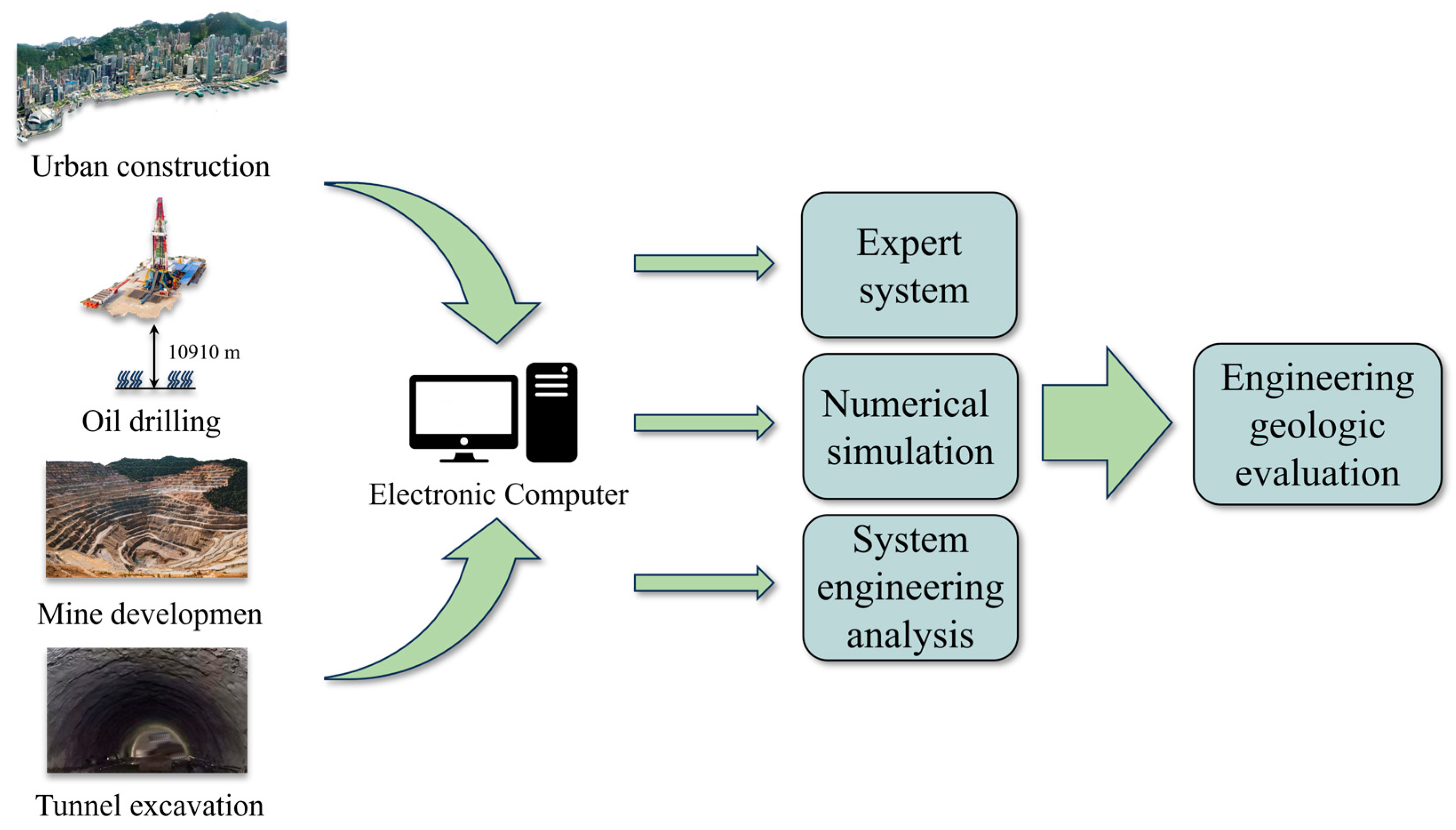
1. Introduction
2. Methods
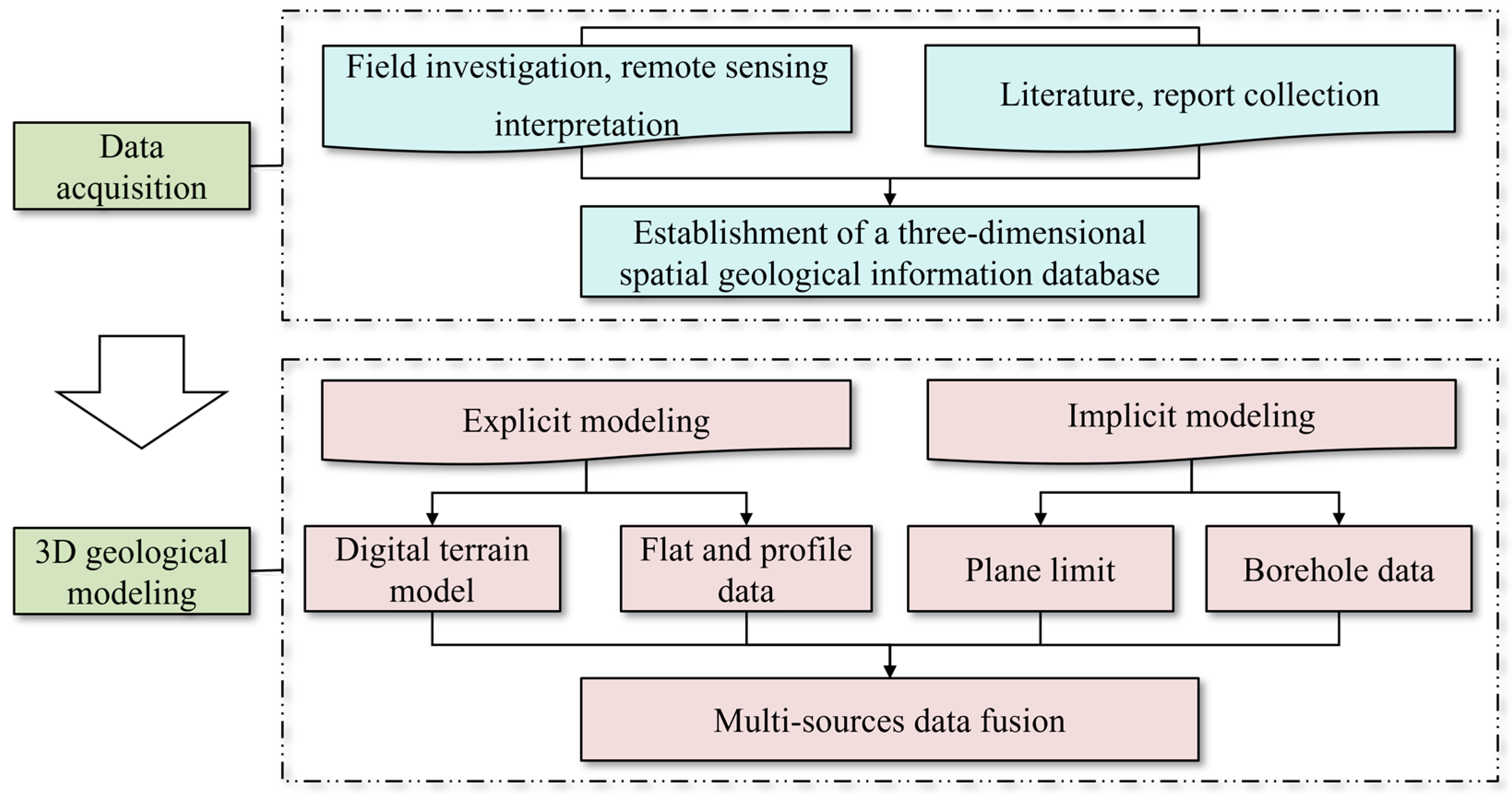
2.1. The Establishment of the Three-Dimensional Geological Model
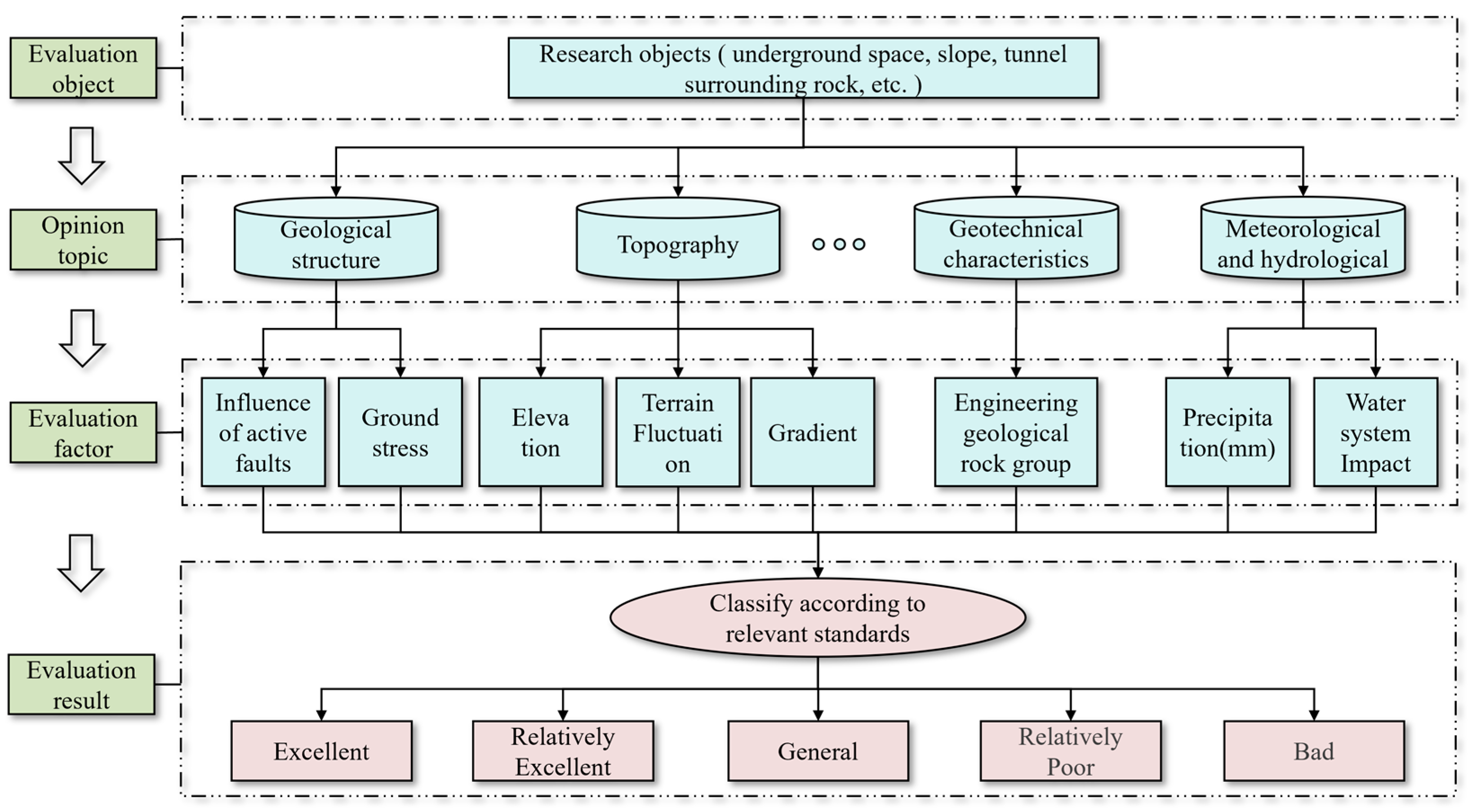
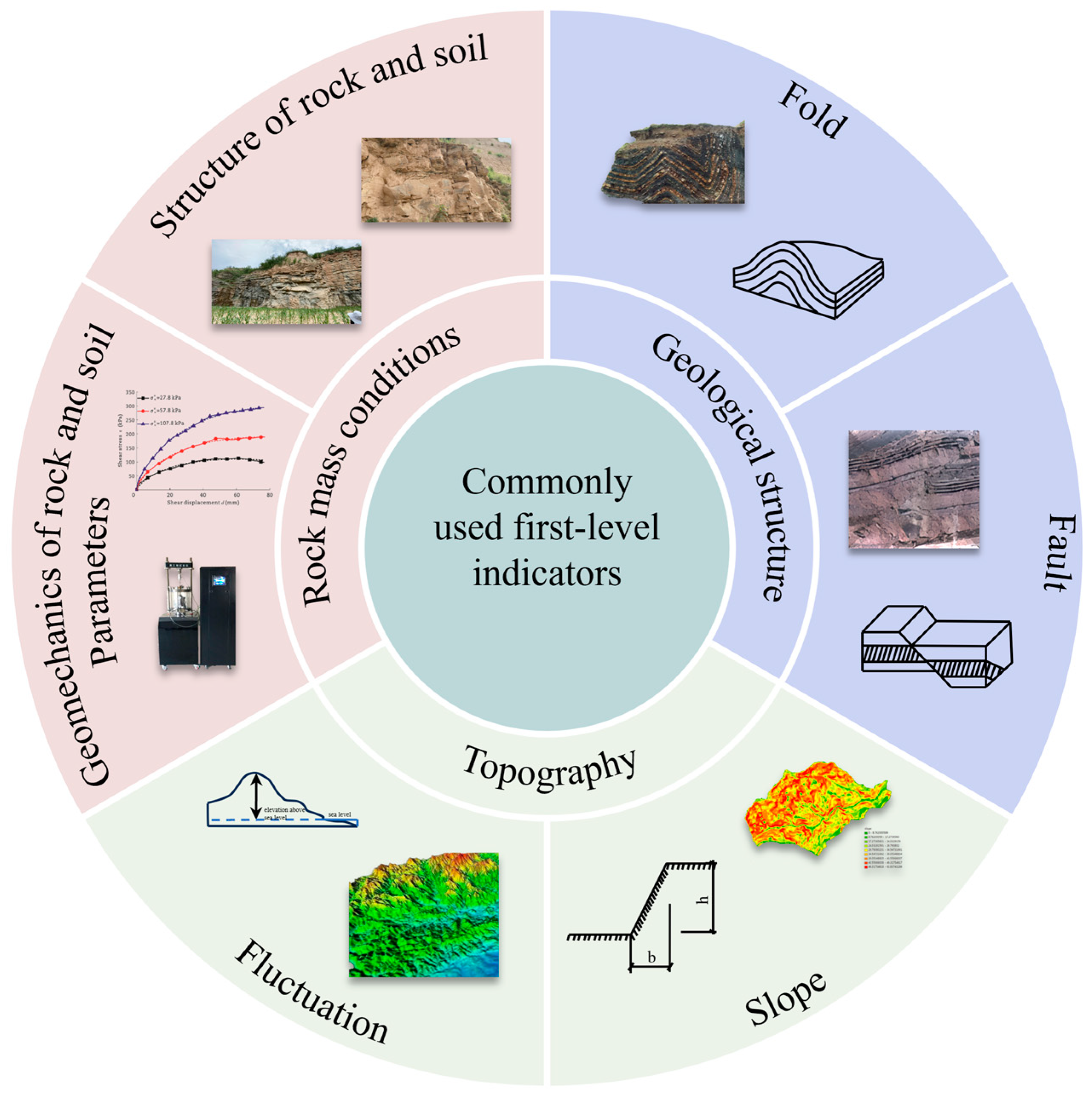
2.2. Construction of the Three-Dimensional Space Evaluation Index System
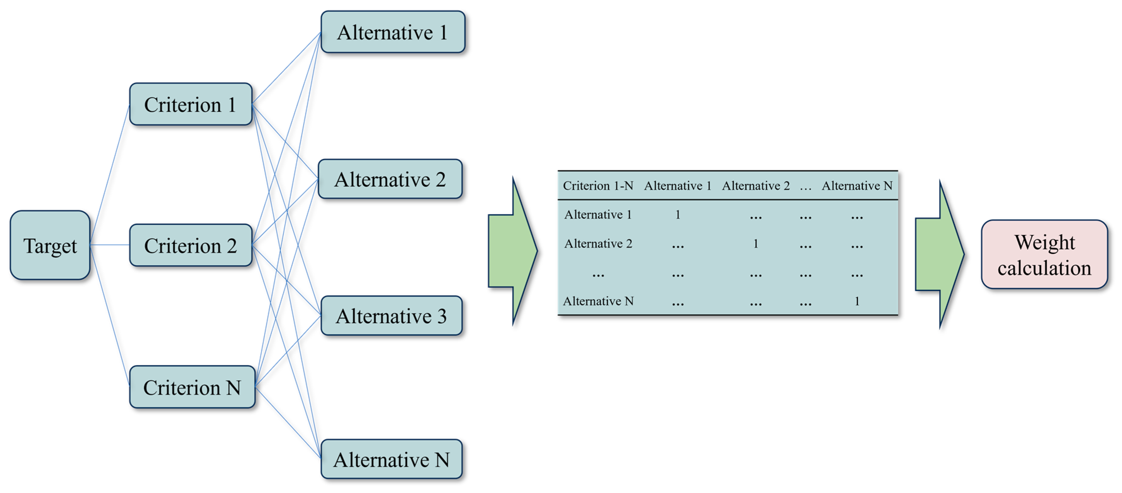
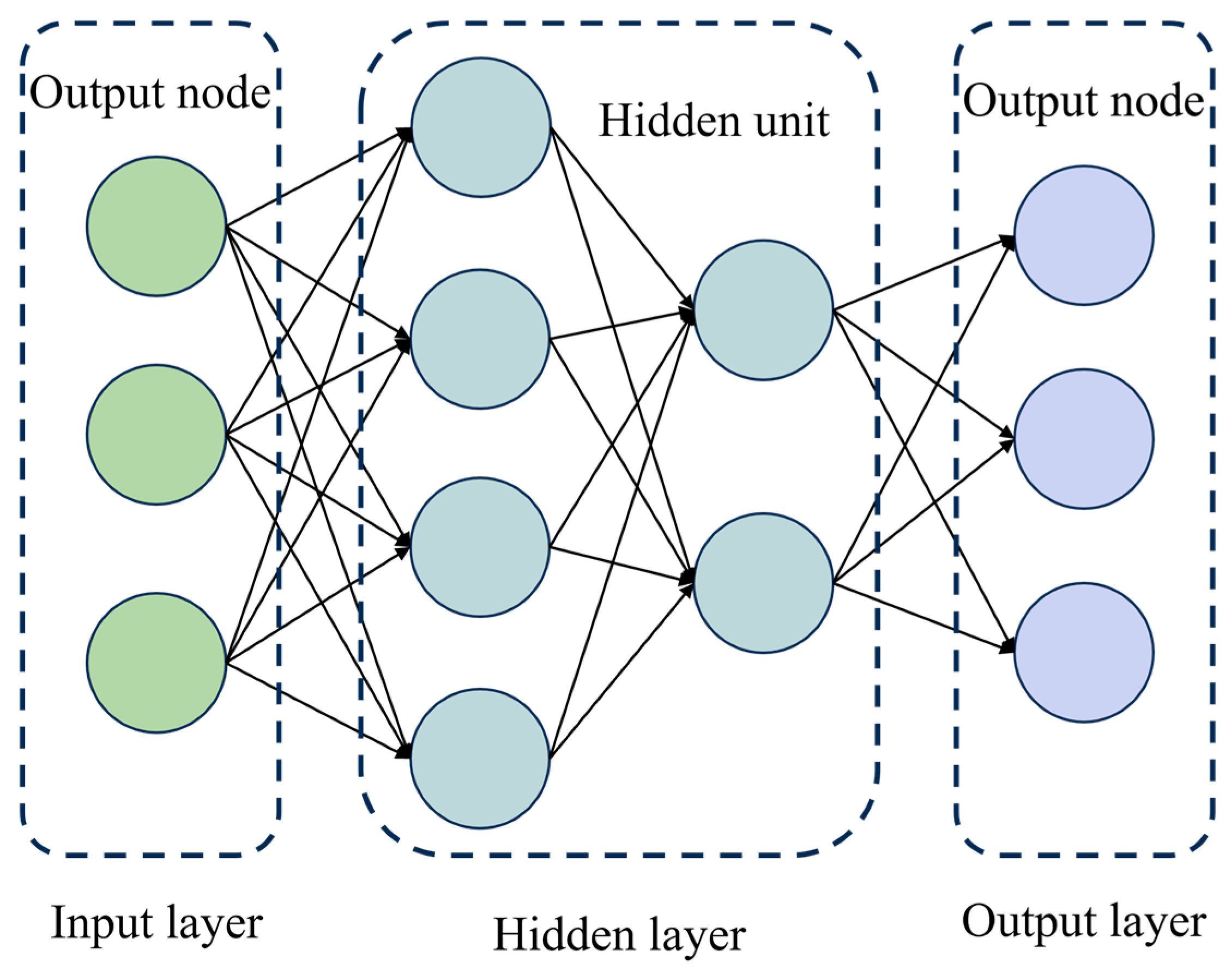
2.3. The Engineering Geology Comprehensive Evaluation Method

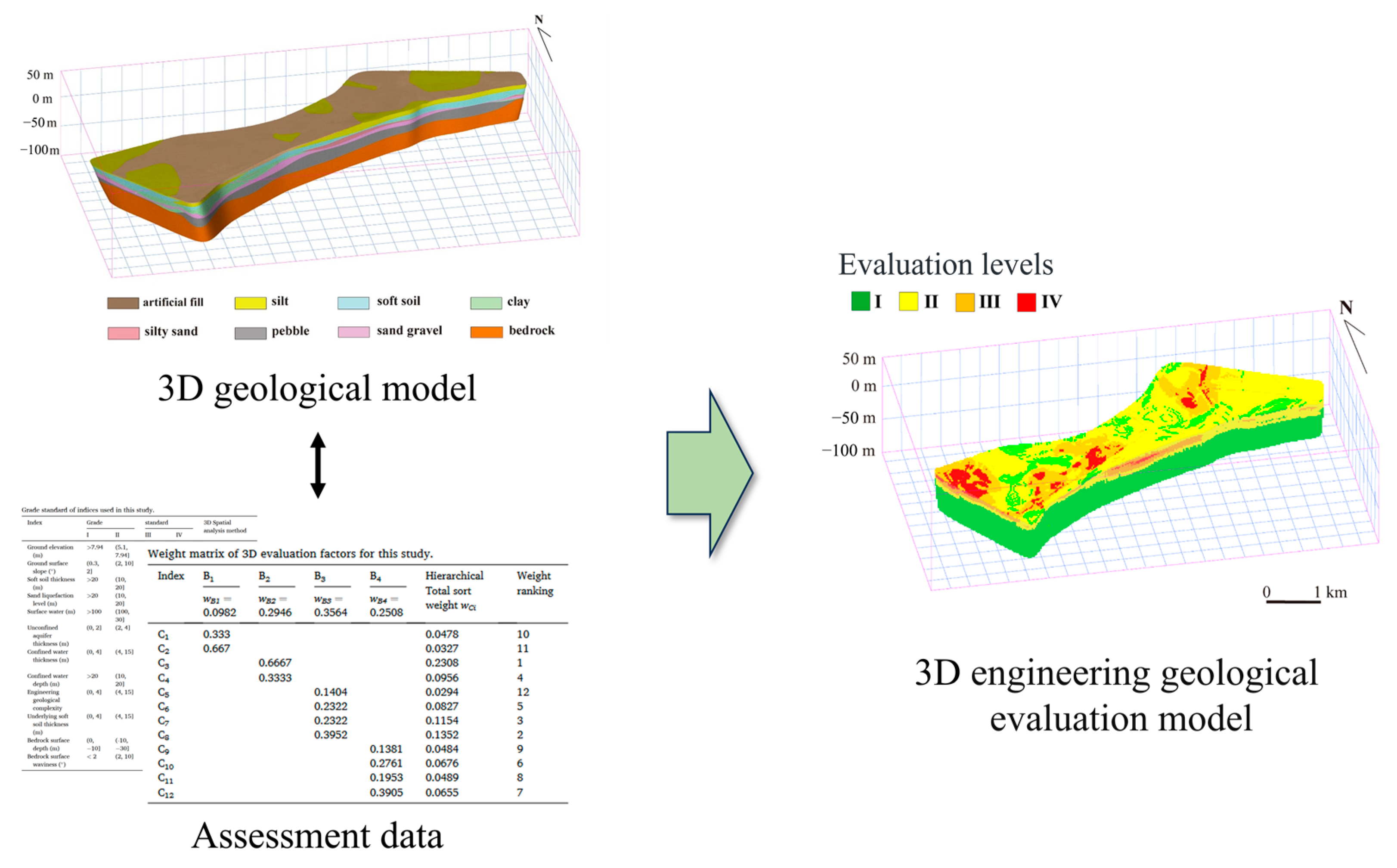
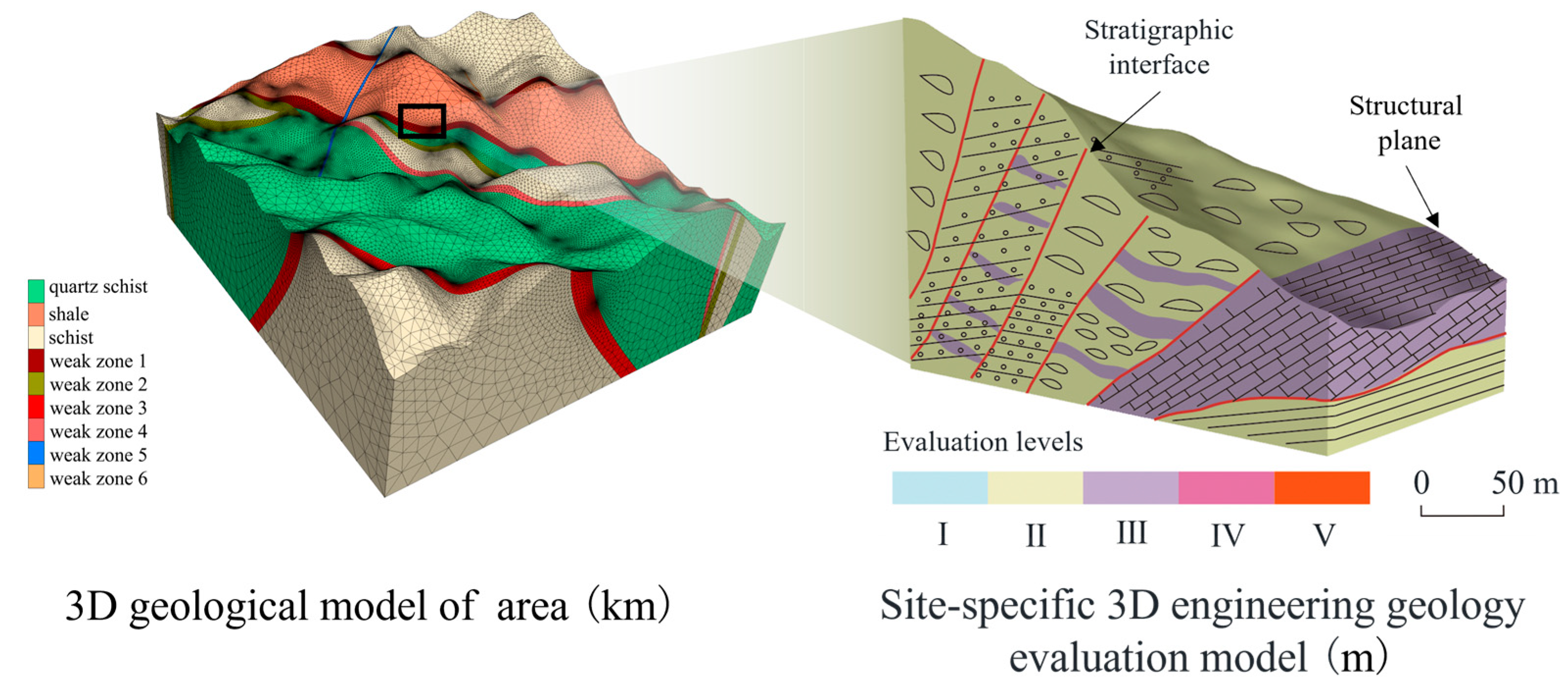
2.4. Construction of the Three-Dimensional Engineering Geological Evaluation Model
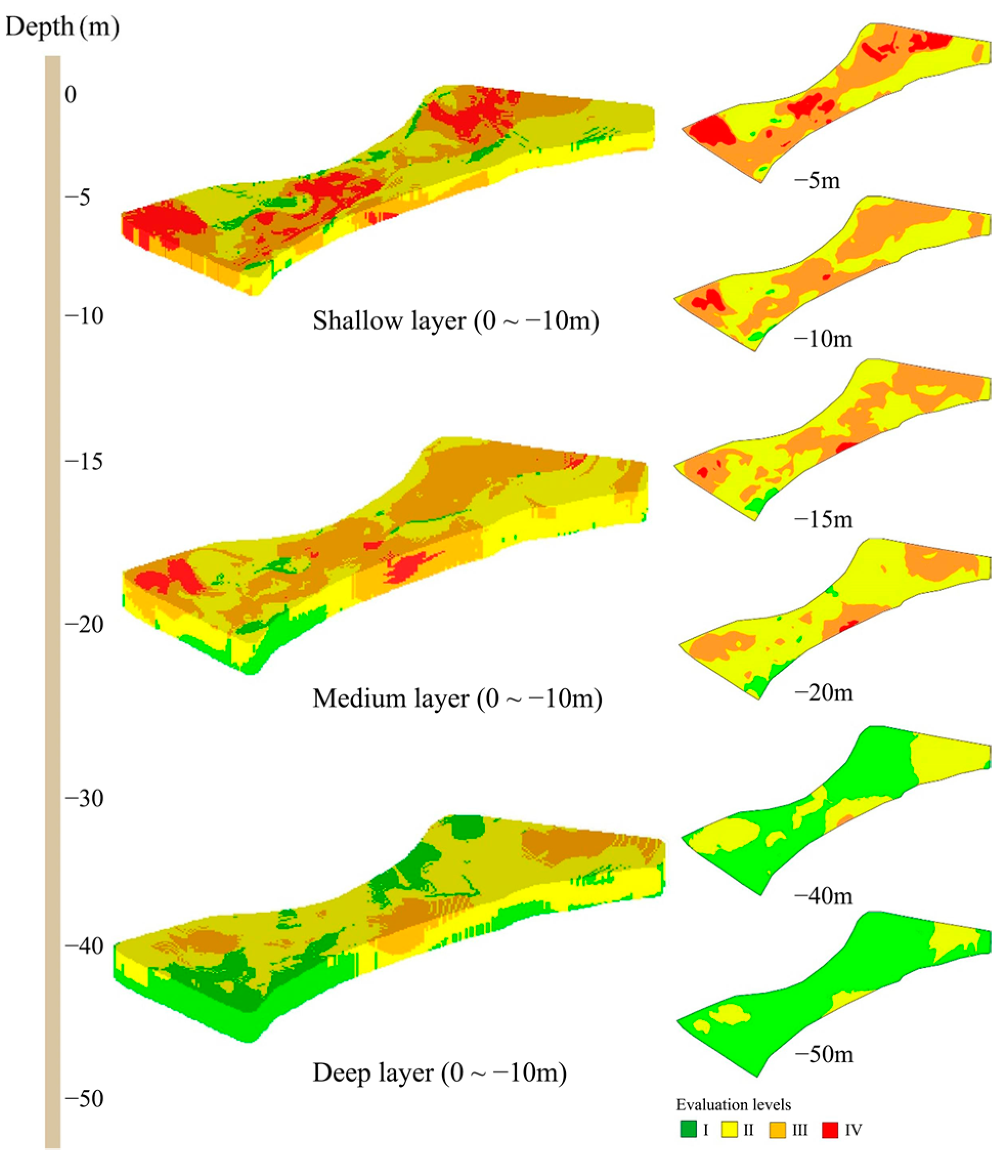
3. Results
4. Discussion
5. Conclusions
Author Contributions
Funding
Institutional Review Board Statement
Informed Consent Statement
Data Availability Statement
Acknowledgments
Conflicts of Interest
References
- Li, Z.; Yang, Y. Introduction to Engineering Geology, 1st ed.; China University of Geosciences Press: Wuhan, China, 2007; pp. 1–5. (In Chinese) [Google Scholar]
- Li, G.; Song, W. Theoretical Method of Engineering Geological Analysis and Evaluation, 1st ed.; Science Press: Beijing, China, 2007; pp. 91–95. (In Chinese) [Google Scholar]
- Sun, G. Achievements and Prospects of Engineering Geological Science in China in the Past Ten Years. Hydrogeol. Eng. Geol. 1993, 1, 9–12. (In Chinese) [Google Scholar]
- Hou, H.S.; Wang, C.S.; Zhang, J.D.; Ma, F.; Fu, W.; Wang, P.J.; Huang, Y.J.; Zou, C.C.; Gao, Y.F.; Gao, Y.; et al. Deep Continental Scientific Drilling Engineering Project in Songliao Basin: Progress in Earth Science Research. China Geol. 2018, 1, 173–186. [Google Scholar] [CrossRef]
- Liu, S.; Li, W. Indicators Sensitivity Analysis for Environmental Engineering Geological Patterns Caused by Underground Coal Mining with Integrating Variable Weight Theory and Improved Matter-Element Extension Model. Sci. Total Environ. 2019, 686, 606–618. [Google Scholar] [CrossRef] [PubMed]
- Dai, F.; Liu, Y.; Wang, S. Urban Geology: A Case Study of Tongchuan City, Shaanxi Province, China. Eng. Geol. 1994, 38, 165–175. [Google Scholar]
- Wang, X.; Zhen, F.; Huang, X.; Zhang, M.; Liu, Z. Factors Influencing the Development Potential of Urban Underground Space: Structural Equation Model Approach. Tunn. Underground Space Technol. 2013, 38, 235–243. [Google Scholar] [CrossRef]
- Zhou, D.; Li, X.; Wang, Q.; Wang, R.; Wang, T.; Gu, Q.; Xin, Y. GIS-based urban underground space resources evaluation toward three-dimensional land planning: A case study in Nantong, China. Tunn. Undergr. Space Technol. 2019, 84, 1–10. [Google Scholar] [CrossRef]
- Dou, F.; Li, X.; Xing, H.; Yuan, F.; Ge, W. 3D Geological Suitability Evaluation for Urban Underground Space Development—A Case Study of Qianjiang Newtown in Hangzhou, Eastern China. Tunn. Underground Space Technol. 2021, 115, 104052. [Google Scholar] [CrossRef]
- Hasan, M.; Shang, Y. Geophysical Evaluation of Geological Model Uncertainty for Infrastructure Design and Groundwater Assessments. Eng. Geol. 2022, 299, 106560. [Google Scholar] [CrossRef]
- Price, S.J.; Terrington, R.L.; Busby, J.; Bricker, S.; Berry, T. 3D Ground-Use Optimization for Sustainable Urban Development Planning: A Case Study from Earls Court, London, UK. Tunn. Underground Space Technol. 2018, 81, 144–164. [Google Scholar] [CrossRef]
- Volk, R.; Stengel, J.; Schultmann, F. Building Information Modeling (BIM) for Existing Buildings—Literature Review and Future Needs. Autom. Constr. 2014, 38, 109–127. [Google Scholar] [CrossRef]
- Lemon, A.M.; Jones, N.L. Building Solid Models from Boreholes and User-Defined Cross-Sections. Comput. Geosci. 2003, 29, 547–555. [Google Scholar] [CrossRef]
- Royse, K.R.; Rutter, H.K.; Entwisle, D.C. Property Attribution of 3D Geological Models in the Thames Gateway, London: New Ways of Visualising Geoscientific Information. Bull. Eng. Geol. Environ. 2009, 68, 1–16. [Google Scholar] [CrossRef]
- Turner, A.K. Challenges and Trends for Geological Modelling and Visualisation. Bull. Eng. Geol. Environ. 2006, 65, 109–127. [Google Scholar] [CrossRef]
- Mathers, S.J.; Burke, H.F.; Terrington, R.L.; Thorpe, S.; Dearden, R.A.; Williamson, J.P.; Ford, J.R. A Geological Model of London and the Thames Valley, Southeast England. Proc. Geol. Assoc. 2014, 125, 373–382. [Google Scholar] [CrossRef]
- Burke, H.; Mathers, S.J.; Williamson, J.P.; Thorpe, S.; Ford, J.; Terrington, R.L. The London Basin Superficial and Bedrock LithoFrame 50 Model; British Geological Survey: London, UK, 2014. [Google Scholar]
- Sun, J. Computer Graphics, 3rd ed.; Tsinghua University Press: Beijing, China, 1998; pp. 26–28. (In Chinese) [Google Scholar]
- Guo, F.; Zheng, B.; Qi, S.; Li, H.; Zhu, H.; Yue, Y.; Xie, H. An Overview of 3D Geological Modeling Techniques and Methods. Eng. Geol. 2024, 32, 1143–1153. (In Chinese) [Google Scholar]
- Cheng, X.; Li, T.; Ma, C.; Han, Y.; Zeng, P.; Huang, J.; Deng, K.; Zhang, Y. A Rapid Modeling Method for Multi-Attribute Three-Dimensional Geological Model and Its Application in High-Stress Tunnels. Eng. Geol. 2023, 31, 959–967. (In Chinese) [Google Scholar]
- Guo, J.; Wu, L.; Zhou, W. Implicit Automatic 3D Modeling Method of Ore Body Based on Radial Basis Function Surface. J. Coal. 2016, 41, 2130–2135. (In Chinese) [Google Scholar]
- Zhang, Z.; Wang, G.; Ma, Z.; Gong, X. Interactive 3D Modeling by Integration of Geoscience Datasets for Exploration Targeting in Luanchuan Mo Polymetallic District, China. Nat. Resour. Res. 2018, 27, 315–346. [Google Scholar] [CrossRef]
- Li, X.; Li, D.; Liu, Z.; Zhao, G.; Wang, W. Determination of the Minimum Thickness of Crown Pillar for Safe Exploitation of a Subsea Gold Mine Based on Numerical Modeling. Int. J. Rock Mech. Min. Sci. 2013, 57, 42–56. [Google Scholar] [CrossRef]
- He, H.; He, J.; Xiao, J.; Zhou, Y.; Liu, Y.; Li, C. 3D Geological Modeling and Engineering Properties of Shallow Superficial Deposits: A Case Study in Beijing, China. Tunn. Underground Space Technol. 2020, 100, 103390. [Google Scholar] [CrossRef]
- Martinez, J.L.; Raiber, M.; Cendón, D.I. Using 3D Geological Modelling and Geochemical Mixing Models to Characterise Alluvial Aquifer Recharge Sources in the Upper Condamine River Catchment, Queensland, Australia. Sci. Total Environ. 2017, 574, 1–18. [Google Scholar] [CrossRef] [PubMed]
- Giacomelli, S.; Zuccarini, A.; Amorosi, A.; Bruno, L.; Paola, G.D.; Martini, A.; Severi, P.; Berti, M. 3D Geological Modelling of the Bologna Urban Area (Italy). Eng. Geol. 2023, 324, 107242. [Google Scholar] [CrossRef]
- Yevalla, G.M.S.; Rodrigue, E.S.; Ndoh, N.E.; Tabod, T.C. Characterization of Subsurface Geology and Hydrogeology in Kribi-Cameroon Using Electrical Resistivity Soundings and 3D-Implicit Modelling: Baseline for Groundwater Resource Management. Groundw. Sustain. Dev. 2024, 25, 101163. [Google Scholar] [CrossRef]
- Jamshidi, C.R.; Kamyab, F.H.; Heidarie, G.S.; Eslami, A. Non-Stationary Realisation of CPT Data: Considering Lithological and Inherent Heterogeneity. Georisk: Assess. Manag. Risk Eng. Syst. Geohazards 2018, 12, 265–278. [Google Scholar] [CrossRef]
- Zhao, C.; Gong, W.; Li, T.; Juang, C.H.; Tang, H.; Wang, H. Probabilistic Characterization of Subsurface Stratigraphic Configuration with Modified Random Field Approach. Eng. Geol. 2021, 288, 106138. [Google Scholar] [CrossRef]
- Hourfar, F.; Salahshoor, K.; Zanbouri, H.; Elkamel, A.; Pourafshary, P.; Moshiri, B. A Systematic Approach for Modeling of Waterflooding Process in the Presence of Geological Uncertainties in Oil Reservoirs. Comput. Chem. Eng. 2018, 111, 66–78. [Google Scholar] [CrossRef]
- Bond, C.E. Uncertainty in Structural Interpretation: Lessons to Be Learnt. J. Struct. Geol. 2015, 74, 185–200. [Google Scholar] [CrossRef]
- Høyer, A.S.; Sandersen, P.B.E.; Andersen, L.T.; Madsen, R.B.; Mortensen, M.H.; Møller, I. Evaluating the Chain of Uncertainties in the 3D Geological Modelling Workflow. Eng. Geol. 2024, 343, 107792. [Google Scholar] [CrossRef]
- Wellmann, J.F.; Regenauer-Lieb, K. Uncertainties Have a Meaning: Information Entropy as a Quality Measure for 3-D Geological Models. Tectonophysics 2012, 526, 207–216. [Google Scholar] [CrossRef]
- González-Garcia, J.; Jessell, M. A 3D Geological Model for the Ruiz-Tolima Volcanic Massif (Colombia): Assessment of Geological Uncertainty Using a Stochastic Approach Based on Bézier Curve Design. Tectonophysics 2016, 687, 139–157. [Google Scholar] [CrossRef]
- Pakyuz-Charrier, E.J.; Lindsay, M.D.; Ogarko, V.; Giraud, J.E.C.D.; Jessell, M.W. Monte Carlo Simulations for Uncertainty Estimation in 3D Geological Modeling, A Guide for Disturbance Distribution Selection and Parameterization. Solid Earth 2018, 9, 385–402. [Google Scholar] [CrossRef]
- Olierook, H.K.H.; Scalzo, R.; Kohn, D.; Chandra, R.; Farahbakhsh, E.; Clark, C.; Reddy, S.M.; Müller, R.D. Bayesian Geological and Geophysical Data Fusion for the Construction and Uncertainty Quantification of 3D Geological Models. Geosci. Front. 2021, 12, 479–493. [Google Scholar] [CrossRef]
- Sun, Z.; Wang, H.; Zhang, B.; Li, Y.; Peng, Z.; Zhang, S. Intelligent Construction Method and Application of Large-Scale Three-Dimensional Complex Discrete Fracture Network Model Based on Particle Swarm Optimization Algorithm. Comput. Geotech. 2024, 171, 106316. [Google Scholar] [CrossRef]
- Huang, J.; Deng, H.; Mao, X.; Chen, G.; Yu, S.; Liu, Z. 3D Modeling of Detachment Faults in the Jiaodong Gold Province, Eastern China: A Bayesian Inference Perspective and Its Exploration Implications. Ore Geol. Rev. 2023, 154, 105307. [Google Scholar] [CrossRef]
- Liu, H.C.; Zhang, N.; Yin, Z.Y. Probabilistic Stratigraphic Modeling from Sparse Boreholes Based on Deep Learning. Géotechnique 2025, 1, 1–35. [Google Scholar]
- Yan, W.; Yang, C.; Shen, P.; Zhou, W. Efficient Probabilistic Tuning of Large Geological Model (LGM) for Underground Digital Twin. Eng. Geol. 2025, 350, 107996. [Google Scholar] [CrossRef]
- Feng, X.T.; Yang, C.X.; He, B.G.; Yao, Z.B.; Hu, L.; Zhang, W.; Kong, R.; Zhao, J.; Liu, Z.B.; Bi, X. Artificial Intelligence Technology in Rock Mechanics and Rock Engineering. Deep Res. Eng. 2024, 1, 100008. [Google Scholar] [CrossRef]
- Pan, D.; Li, Y.; Wang, X.; Xu, Z. Intelligent Image-Based Identification and 3-D Reconstruction of Rock Fractures: Implementation and Application. Tunn. Underground Space Technol. 2024, 145, 105582. [Google Scholar] [CrossRef]
- Bobylev, N. Mainstreaming Sustainable Development into a City’s Master Plan: A Case of Urban Underground Space Use. Land Use Policy 2009, 26, 1128–1137. [Google Scholar] [CrossRef]
- Wu, Y.; Wen, H.; Fu, M. A Review of Research on the Value Evaluation of Urban Underground Space. Land 2024, 13, 474. [Google Scholar] [CrossRef]
- Wen, T.; Wang, Y.; Tang, H. Quantitative Evaluation of Rock Brittle Property Based on Energy Evolution and Its Application in Three Gorges Reservoir Area. J. Earth Sci. 2024, 35, 2013–2029. [Google Scholar] [CrossRef]
- Wald, D.J.; Allen, T.I. Topographic Slope as a Proxy for Seismic Site Conditions and Amplification. Bull. Seismol. Soc. Am. 2007, 97, 1379–1395. [Google Scholar] [CrossRef]
- Dong, F.; Yin, H.; Cheng, W.; Li, Y.; Fan, J.; Ding, H.; Jia, C. Fine Structure Exploration and 3D Quantitative Evaluation Model. Bull. Eng. Geol. Environ. 2024, 83, 392. [Google Scholar] [CrossRef]
- Zhao, J.; Lee, K.W. Construction and Utilization of Rock Caverns in Singapore Part C: Planning and Location Selection. Tunneling Undergr. Space Technol. 1996, 11, 81–84. [Google Scholar] [CrossRef]
- Lu, Z.; Wu, L.; Zhuang, X.; Rabczuk, T. Quantitative Assessment of Engineering Geological Suitability for Multilayer Urban Underground Space. Tunneling Undergr. Space Technol. 2016, 59, 65–76. [Google Scholar] [CrossRef]
- Liu, J.; Nie, H.; Xu, L.; Xiao, C.; Li, W.; Yuan, G.; Huang, Y.; Ji, X.; Li, T. Assessment of Ecological Geological Vulnerability in Mu Us Sandy Land Based on GIS and Suggestions for Ecological Protection and Restoration. China Geol. 2025, 8, 117–140. [Google Scholar] [CrossRef]
- Dai, C.; Zhou, Z.; Zhang, H.; Jiang, K.; Li, H.; Yu, H. Service Reliability Evaluation of Highway Tunnel Based on Digital Image Processing. PLoS ONE 2023, 18, e0288633. [Google Scholar] [CrossRef]
- Saaty, T.L. A Scaling Method for Priorities in Hierarchical Structures. J. Math. Psychol. 1977, 15, 234–281. [Google Scholar] [CrossRef]
- Shannon, C.E. A Mathematical Theory of Communication. Bell Syst. Tech. J. 1948, 27, 379–423. [Google Scholar] [CrossRef]
- Rarità, L.; Stamova, I.; Tomasiello, S. Numerical Schemes and Genetic Algorithms for the Optimal Control of a Continuous Model of Supply Chains. Appl. Math. Comput. 2021, 388, 125464. [Google Scholar] [CrossRef]
- Peng, Z.; Su, P.; Chen, W.; Tao, H.; Xia, Z.; Bo, T. 3D Quality Evaluation of Rock Mass in Urban Underground Space Based on Improved Fuzzy Analytic Hierarchy Process. J. Civ. Eng. 2022, 26, 4829–4839. [Google Scholar] [CrossRef]
- Gao, J.; Xu, Z.; Liu, D.; Cao, H. Application of the Model Based on Fuzzy Consistent Matrix and AHP in the Assessment of Fire Risk of Subway Tunnel. Procedia Eng. 2014, 71, 591–596. [Google Scholar] [CrossRef]
- Sterling, R.L.; Nelson, S. Planning the Development of Underground Space. Undergr. Space 1982, 7, 86–103. [Google Scholar]
- Qiu, D.; Chen, Q.; Xue, Y.; Su, M.; Liu, Y.; Cui, J.; Zhou, B. A New Method for Risk Assessment of Water Inrush in a Subsea Tunnel Crossing Faults. Mar. Georesources Geotech. 2022, 40, 679–689. [Google Scholar] [CrossRef]
- Yalcin, M.; Kalaycioglu, S.; Basaran, C.; Sari, F.; Gul, F.K. Exploration of Potential Geothermal Fields Using GIS-Based Entropy Method, A Case Study of the Sandikli. Renew. Energy 2024, 121, 719. [Google Scholar] [CrossRef]
- Zhou, H.; Liao, X.; Chen, S.; Feng, T.; Wang, Z. Rock Burst Risk Assessment of Deep Buried Tunnel Based on Combination Weighting and Unascertained Measure—Taking Sangzhuling Tunnel in Sichuan-Tibet Traffic Corridor as an Example. Earth Sci. 2022, 47, 2130–2148. (In Chinese) [Google Scholar]
- Dou, F.; Xing, H.; Li, X.; Yuan, F.; Lu, Z.; Li, X.; Ge, W. 3D Geological Suitability Evaluation for Urban Underground Space Development Based on Combined Weighting and Improved TOPSIS. Nat. Resour. Res. 2022, 31, 693–711. [Google Scholar] [CrossRef]
- Anagnostopoulos, K.P.; Mamanis, G. The Mean–Variance Cardinality Constrained Portfolio Optimization Problem: An Experimental Evaluation of Five Multiobjective Evolutionary Algorithms. Expert Syst. Appl. 2011, 38, 14208–14217. [Google Scholar] [CrossRef]
- Durmisevic, S.; Sariyildiz, S. A Systematic Quality Assessment of Underground Spaces—Public Transport Stations. Cities 2001, 18, 13–23. [Google Scholar] [CrossRef]
- Tan, F.; Wang, J.; Jiao, Y.Y.; Ma, B.C.; He, L.L. Suitability Evaluation of Underground Space Based on Finite Interval Cloud Model and Genetic Algorithm Combination Weighting. Tunn. Undergr. Space Technol. 2021, 108, 103743. [Google Scholar] [CrossRef]
- Lin, C.J.; Zhang, M.; Li, L.P.; Zhou, Z.Q.; Liu, S.; Li, T. Risk Assessment of Tunnel Construction Based on Improved Cloud Model. J. Perform. Constr. Facil. 2020, 34, 04020028. [Google Scholar] [CrossRef]
- Shen, J.; Bao, X.; Chen, X.; Wu, X.; Qiu, T.; Cui, H. Seismic Resilience Assessment Method for Tunnels Based on Cloud Model Considering Multiple Damage Evaluation Indices. Tunn. Undergr. Space Technol. 2025, 157, 106360. [Google Scholar] [CrossRef]
- Yan, F.; Zhang, Q.; Ye, S.; Ren, B. A Novel Hybrid Approach for Landslide Susceptibility Mapping Integrating Analytical Hierarchy Process and Normalized Frequency Ratio Methods with the Cloud Model. Geomorphology 2019, 327, 170–187. [Google Scholar] [CrossRef]
- Zhang, Y.; Guo, D.; Song, Z.; Zhang, Y.; Ruan, L.; Yan, Z. Health Evaluation of Shield Tunnel Lining Using Combination Weighting and Finite Interval Cloud Model. Eng. Appl. Artif. Intell. 2025, 139, 109645. [Google Scholar] [CrossRef]
- Hou, W.; Yang, L.; Deng, D.; Ye, J.; Clarke, K.; Yang, Z.; Zhuang, W.; Liu, J.; Huang, J. Assessing Quality of Urban Underground Spaces by Coupling 3D Geological Models: The Case Study of Foshan City, South China. Comput. Geosci. 2016, 89, 1–11. [Google Scholar] [CrossRef]
- Deng, F.; Pu, J.; Huang, Y.; Han, Q. 3D Geological Suitability Evaluation for Underground Space Based on the AHP-Cloud Model. Undergr. Space 2023, 8, 109–122. [Google Scholar] [CrossRef]
- Pu, J.; Huang, Y.; Bi, Y.; Guo, Z.; Deng, F.; Li, X.; Xu, C. 3D Suitability Evaluation of Urban Underground Space Using a Variable Weight Method and Considering Ground Restrictions. Undergr. Space 2024, 19, 208–226. [Google Scholar] [CrossRef]
- Jia, N.; Mitani, Y.; Xie, M.; Djamaluddin, I. Shallow Landslide Hazard Assessment Using a Three-Dimensional Deterministic Model in a Mountainous Area. Comput. Geotech. 2012, 45, 1–10. [Google Scholar] [CrossRef]
- Palazzolo, N.; Peres, D.J.; Bordoni, M.; Meisina, C.; Creaco, E.; Cancelliere, A. Improving Spatial Landslide Prediction with 3D Slope Stability Analysis and Genetic Algorithm Optimization: Application to the Oltrepò Pavese. Water 2021, 13, 801. [Google Scholar] [CrossRef]
- Dai, K.; Chen, C.; Shi, X.; Wu, M.; Feng, W.; Xu, Q.; Liang, R.; Zhuo, G.; Li, Z. Dynamic Landslides Susceptibility Evaluation in Baihetan Dam Area During Extensive Impoundment by Integrating Geological Model and InSAR Observations. Int. J. Appl. Earth Obs. Geoinf. 2023, 116, 103157. [Google Scholar] [CrossRef]
- Ugenti, A.; Mevoli, F.A.; de Lucia, D.; Lollino, P.; Fazio, N.L. Moving Beyond Single Slope Quantitative Analysis: A 3D Slope Stability Assessment at Urban Scale. Eng. Geol. 2025, 344, 107841. [Google Scholar] [CrossRef]
- Zhang, J.Z.; Jiang, Q.H.; Zhang, D.M.; Huang, H.W.; Liu, Z.Q. Influence of Geological Uncertainty and Soil Spatial Variability on Tunnel Deformation and Their Importance Evaluation. Tunnel. Undergr. Space Technol. 2024, 152, 105930. [Google Scholar] [CrossRef]
- Sun, Y.; Su, H.; Xiao, P.; Li, P.; Li, B.; Zhou, X.; Bian, K.; Xu, N. Visualization and Early Warning Analysis of Damage Degree of Surrounding Rock Mass in Underground Powerhouse. Int. J. Mining Sci. Technol. 2023, 33, 717–731. [Google Scholar] [CrossRef]
- Fegh, A.; Riahi, M.A.; Norouzi, G.H. Permeability Prediction and Construction of 3D Geological Model: Application of Neural Networks and Stochastic Approaches in an Iranian Gas Reservoir. Neural Comput. Appl. 2013, 23, 1763–1770. [Google Scholar] [CrossRef]
- Thanh, H.V.; Sugai, Y.; Nguele, R.; Sasaki, K. Integrated Workflow in 3D Geological Model Construction for Evaluation of CO2 Storage Capacity of a Fractured Basement Reservoir in Cuu Long Basin, Vietnam. Int. J. Greenhouse Gas Control 2019, 90, 102826. [Google Scholar] [CrossRef]
- Akinwumiju, A.A.; Satterfield, D.; Phethean, J.J.J. Evaluation of Shale Oil and Gas Plays—Part I: Shale Reservoir Property Modelling of the North Sea Kimmeridge Clay Formation. Mar. Pet. Geol. 2024, 164, 106824. [Google Scholar] [CrossRef]
- Guo, T.K.; Xue, L.R.; Chen, M.; Zhang, B.; Li, Z.T.; Huang, W.J.; Liu, X.Q.; Qu, Z.Q. Geological-Engineering Comprehensive Evaluation Model and Application of Feasibility of Hydraulic Fracturing in Hydrate-Bearing Sediments. Pet. Sci. 2024, 22, 1140–1154. [Google Scholar] [CrossRef]
- Zou, T.; Gu, Y.; Liu, H.; Lin, Y.; Zhang, L.; Zhang, Y. High-Resolution 3D Hydrodynamic Modeling and Comprehensive Assessment of Tidal Current Energy Resources. Ocean Eng. 2024, 313, 119514. [Google Scholar] [CrossRef]
- Chang, P.Y.; Lo, W.; Song, S.R.; Ho, H.R.; Wu, C.S.; Chen, C.S.; Lai, Y.C.; Chen, H.F.; Lu, H.Y. Evaluating the Chingshui Geothermal Reservoir in Northeast Taiwan with a 3D Integrated Geophysical Visualization Model. Geothermics 2014, 50, 91–100. [Google Scholar] [CrossRef]
- Blannin, R.; Frenzel, M.; Tolosana-Delgado, R.; Büttner, P.; Gutzmer, J. 3D Geostatistical Modelling of a Tailings Storage Facility: Resource Potential and Environmental Implications. Ore Geol. Rev. 2023, 154, 105337. [Google Scholar] [CrossRef]
- Su, Y.; Yao, B. The Main Geological Model of Deformation and Failure of Rock Slope in China. Chin. J. Rock Mech. Eng. 1983, 1, 67–76. (In Chinese) [Google Scholar]


| Contrast Dimension | Explicit Modeling | Implicit Modeling |
|---|---|---|
| Method | Geological body contour line connection method based on sequence exploration line profile | Interpolation algorithm |
| Precision | Higher (relying on expert experience) | General (depending on the quality and quantity of borehole data) |
| Difficulty in operation | Difficult | Easy |
| The difficulty of updating data | Difficult | Easy |
| Applicable scene | Engineering geological modeling and construction of engineering geological interface | Engineering geological analysis, resource exploration, and evaluation |
| Evaluating Indicator | |||||
|---|---|---|---|---|---|
| Subjective weights | 0.205 | 0.205 | 0.065 | 0.328 | 0.197 |
| Objective weights | 0.117 | 0.267 | 0.040 | 0.364 | 0.212 |
| Combination weight | 0.164 | 0.233 | 0.054 | 0.345 | 0.204 |
Disclaimer/Publisher’s Note: The statements, opinions and data contained in all publications are solely those of the individual author(s) and contributor(s) and not of MDPI and/or the editor(s). MDPI and/or the editor(s) disclaim responsibility for any injury to people or property resulting from any ideas, methods, instructions or products referred to in the content. |
© 2025 by the authors. Licensee MDPI, Basel, Switzerland. This article is an open access article distributed under the terms and conditions of the Creative Commons Attribution (CC BY) license (https://creativecommons.org/licenses/by/4.0/).
Share and Cite
Wei, G.; Zheng, B.; Dong, J.; Yang, Y.; Yang, G.; Song, S.; Guo, S.; Qi, S. Research Progress of Three-Dimensional Engineering Geological Evaluation Modeling. Sustainability 2025, 17, 3739. https://doi.org/10.3390/su17083739
Wei G, Zheng B, Dong J, Yang Y, Yang G, Song S, Guo S, Qi S. Research Progress of Three-Dimensional Engineering Geological Evaluation Modeling. Sustainability. 2025; 17(8):3739. https://doi.org/10.3390/su17083739
Chicago/Turabian StyleWei, Gaoang, Bowen Zheng, Jinyu Dong, Yue Yang, Guoxiang Yang, Shuaihua Song, Songfeng Guo, and Shengwen Qi. 2025. "Research Progress of Three-Dimensional Engineering Geological Evaluation Modeling" Sustainability 17, no. 8: 3739. https://doi.org/10.3390/su17083739
APA StyleWei, G., Zheng, B., Dong, J., Yang, Y., Yang, G., Song, S., Guo, S., & Qi, S. (2025). Research Progress of Three-Dimensional Engineering Geological Evaluation Modeling. Sustainability, 17(8), 3739. https://doi.org/10.3390/su17083739