Article

Spatial Evolution and Influencing Factors of Rural Tourism Destinations in an Ecologically Fragile Region of Northwest China—The Case of Lanzhou City

1
Tourism Department, School of Economics & Management, Shanghai Maritime University, 1550 Haigang Avenue, Pudong New Area, Shanghai 201306, China
2
Key Laboratory of Ecological Safety and Sustainable Development in Arid Lands, Northwest Institute of Eco-Environment and Resources, Chinese Academy of Sciences, 320 Donggang West Road, Lanzhou 730000, China
3
School of Marxism, Shanghai Maritime University, 1550 Haigang Avenue, Pudong New Area, Shanghai 201306, China
*
Author to whom correspondence should be addressed.
Sustainability 2025, 17(8), 3618; https://doi.org/10.3390/su17083618
Submission received: 2 February 2025 / Revised: 28 March 2025 / Accepted: 1 April 2025 / Published: 17 April 2025

Abstract

Rural tourism has become a key driver of rural revitalization in China, contributing to poverty alleviation while also irreversibly altering the spatial evolution of rural settlements. In the ecologically fragile regions of northwest China, the rapid expansion of rural tourism destinations has raised ecological concerns, particularly regarding land resource utilization. Therefore, it is crucial to examine the phenomenon of industrial agglomeration in the evolution of rural tourism within the context of tourism-driven poverty alleviation. This study uses Lanzhou City as a case study and employs nearest neighbor analysis and kernel density estimation to analyze the spatial agglomeration patterns of rural tourism destinations, focusing on agglomeration forms, scales, and patterns. Additionally, it explores the spatial coupling distribution between agglomeration levels and influencing factors. The results show that from 1987 to 2022, the development of rural tourism destinations in Lanzhou City has progressed through several stages, from initial emergence to rapid growth. The form of industrial agglomeration has shifted from a dispersed to a clustered distribution, gradually expanding from urban centers to peripheral areas. The spatial agglomeration follows a multi-core hierarchical point-axial diffusion model, forming multiple core and sub-core agglomeration zones of varying scales. This transformation is primarily driven by geographical factors, transportation accessibility, and the presence of high-quality tourist attractions. However, a comparison of land use changes and ecological vulnerability indices over multiple periods indicates that the industrial agglomeration of rural tourism has led to irregular land use patterns and ecosystem instability. Finally, based on the complex relationship between rural tourism development, industrial agglomeration, and ecological sustainability, this study proposes strategies for the development of rural tourism in Lanzhou City, with the aim of providing valuable insights for the development of rural tourism in ecologically fragile regions of China.

1. Introduction

With the continuous expansion of tourism activities and the growing demand of urban residents for leisure, ecology, and experiential travel, rural tourism has emerged as a new tourism model accompanying the urbanization process [1]. Rural tourism encompasses various subcategories, such as agritourism and village tourism, and aims to foster sustainable rural development by enhancing the rural tourism environment of each region [2]. As an effective rural development strategy, rural tourism has been widely promoted in both developing and developed countries due to its energy efficiency and ecological sustainability [3,4]. It has increasingly become a vital driver of rural economic growth and an important mechanism for enhancing farmer income [5]. Additionally, it plays a crucial role in preserving natural and cultural heritage, landscapes, traditions, and local customs [6,7].
As the spatial foundation of tourism activities, the distribution of rural tourism destinations reflects the competitiveness of rural tourism in a given region. International research on the spatial structure of rural tourism began relatively early, leading to a well-established body of literature. Existing studies have primarily focused on the spatial structural characteristics of rural tourism destinations [8], spatial evolution patterns [9], influencing factors [10,11,12], and development and operational models [13]. Spatial clustering is recognized as a key trend in the efficient development of tourism [14], and the agglomeration of tourism industries in rural areas contributes to economic growth and enhances tourism competitiveness [15]. However, as the tourism industry evolves over time and undergoes spatial restructuring, its scale and effectiveness are influenced by various internal and external factors [16,17]. Moreover, the clustering of rural tourism industries may also have negative effects, such as a lack of product differentiation and disorderly competition [18].
Since the late 1980s, rural tourism in China has gradually developed and become a key pillar of the rural economy. With the implementation of the rural revitalization strategy, the development of rural tourism has driven the transformation of rural settlements, further contributing to the urbanization process. Encouraged by national policies and market demand, rural tourism has leveraged its industrial linkages to create employment opportunities for surplus labor, reduce the urban–rural income gap, and contribute to common prosperity [19]. However, under the dual impetus of rural poverty alleviation and tourism industry development, traditional rural spatial structures and functions have undergone significant transformations, giving rise to diverse industrial forms. Related research on the spatial evolution of rural tourism destinations in China can be categorized into two main areas. From a theoretical standpoint, tourism geography scholars have endeavored to leverage established theories of regional spatial organization to elucidate the evolutionary patterns of rural tourism destination configurations, such as the point-axis theory [20] and the core–periphery theory [21]. From an empirical perspective, scholars have focused on spatial development models and influencing factors of rural tourism, identifying tourism agglomeration areas, which have been widely applied in tourism planning, rural policymaking, and industry practices [22,23,24,25]. The agglomeration of the rural tourism industry is essentially a regional phenomenon characterized by the concentration of tourism enterprises, resulting from the continuous enrichment and clustering of different tourism types. In terms of geographic environmental factors, the distribution of the rural tourism industry around major cities exhibits a distance-decay pattern, meaning that the farther away from the city, the fewer rural tourism destinations there are [26]. Regarding socio-economic factors, the rural tourism industry demonstrates various clustering patterns, including primary clustering, embedded clustering, and integrated clustering. During the dynamic process of rural tourism destination clustering [22], both the scale and configuration of these clusters continuously evolve. In China, the spatial distribution of the rural tourism industry either exhibits a radiating pattern centered on scenic attractions [23] or follows a point-axis model characterized by a circular recreational belt surrounding urban areas [20,27]. The formation mechanisms of rural tourism clusters remain a subject of debate. Natural resource endowment, transportation accessibility, and topographical features are critical factors influencing the spatial layout of rural tourism destinations. Given that the rural tourism industry relies on the production, living, and ecological environments of rural areas, it is a typical resource- and market-oriented industry. Additionally, economic development levels, market potential, and policy frameworks play significant roles in shaping rural tourism spatial structures [28]. Furthermore, the role of government as an organizational driver of rural tourism agglomeration, in conjunction with other factors, has been instrumental in shaping the spatial evolution of rural tourism destinations [29].
Rural tourism is one of the key strategies for targeted poverty alleviation, and there is a strong correlation between tourism in impoverished mountainous regions and environmental issues globally [30]. Mountainous areas, characterized by high elevations, steep slopes, poor soil fertility, low vegetation coverage, and significant soil erosion, are ecologically vulnerable and represent areas of low socio-economic development [31]. Rural tourism contributes to regional development by generating economic growth and improving infrastructure, but also brings profound disruptions to regional resource allocation, household livelihood choices, and social culture. Additionally, the unequal distribution of tourism benefits exacerbates social conflicts, thereby significantly increasing the complexity and vulnerability of the socio-ecological system in rural tourism destinations [32]. This intensifies the complexity and vulnerability of the socio-ecological system in rural tourism destinations [32]. On one hand, the rapid development of rural tourism destinations has led to the unchecked expansion of rural settlements, rural hollowing, and the irrational use of land, causing the fragmentation of traditional regional functions and generating conflicts between the preservation of traditional villages and tourism development [33,34,35,36]. On the other hand, the influx of large numbers of tourists and the development of non-ecological tourism activities have severe negative impacts on soil, water quality, and vegetation, thereby exacerbating ecological vulnerability [37]. Therefore, it is essential to study the spatial agglomeration and evolution of the rural tourism industry in ecologically fragile areas to effectively implement targeted tourism poverty alleviation. However, there is a limited body of research that has integrated the spatial layout of rural tourism with environmental issues within the same analytical framework, and few studies have analyzed the evolution and driving factors of rural tourism in ecologically fragile mountainous areas. In this context, this study selected Lanzhou as a representative city in the ecologically fragile mountainous region of northwest China. By comprehensively considering the driving factors of rural tourism in impoverished mountainous areas, this study employed GIS spatial analysis methods to evaluate the spatial layout and evolution of rural tourism sites in Lanzhou City over the past 20 years. Additionally, it explored the spatial differentiation patterns and driving factors of rural tourism point agglomeration, providing scientific decision-making support for the development of rural tourism in ecologically fragile areas. Theoretically, this study advances the understanding of the interaction between rural tourism poverty alleviation and environmental protection, while also offering practical insights for policy formulation and implementation in the coordination of rural tourism development and ecological conservation.

2. Study Area and Data
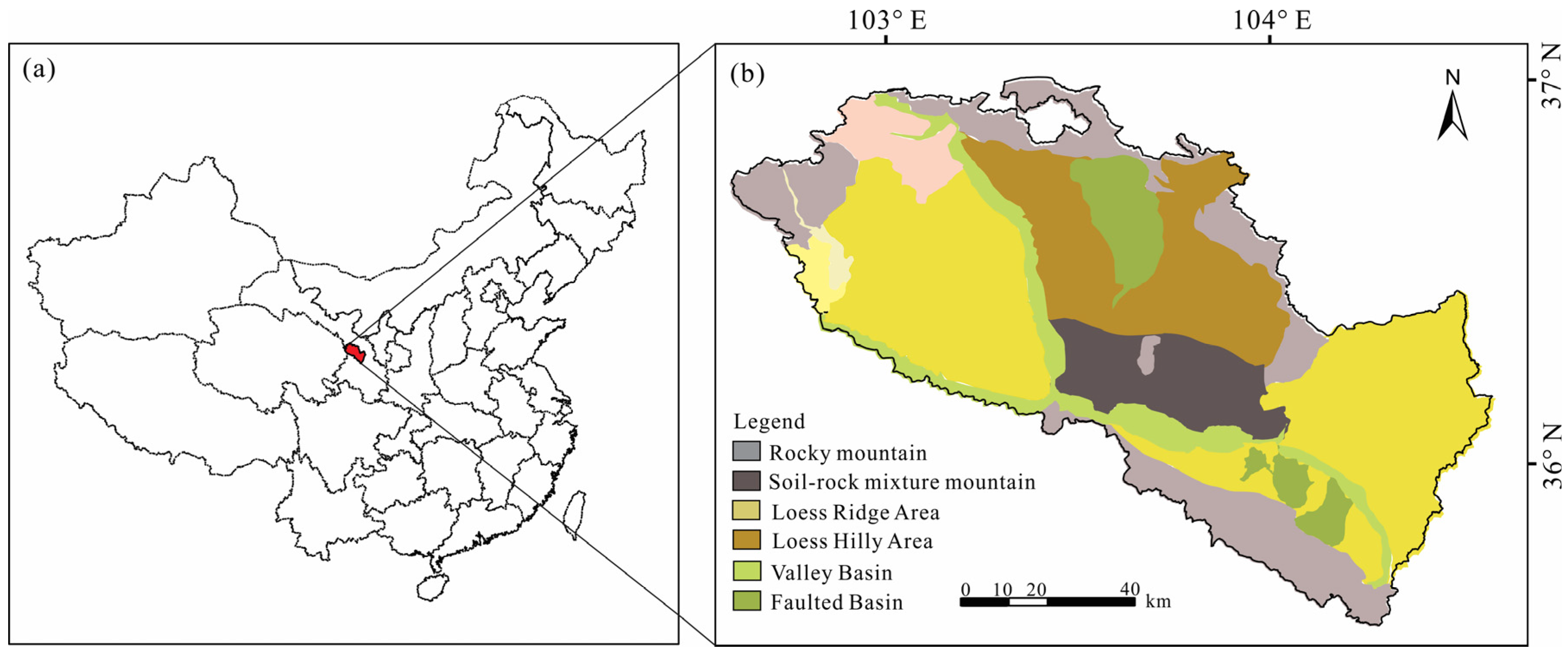
2.1. Study Area

Lanzhou, the capital of Gansu Province, is a key economic hub in the upper reaches of the Yellow River and serves as a vital link connecting eastern, central, and western China. Geographically, the city is situated in the western part of the Longxi Loess Plateau and the northeastern edge of the Qinghai–Tibet Plateau, representing a transitional zone between China’s first and second topographic steps. The majority of the region consists of loess-covered hills and basins at altitudes ranging from 1450 m to 2500 m, and it is characterized by low vegetation coverage, thereby classifying it as an ecologically fragile area [38]. The climate is classified as temperate semi-arid, with an average annual precipitation of 325 mm, an annual evaporation rate of 1486 mm, and an average annual temperature of 9.3 °C. The forest coverage rate in Lanzhou City is relatively low (8.77%), with the majority of forests located in the southern Xinglong Mountain and Mahanshan Mountain. The rapid urban expansion has led to a growing demand for both agricultural and construction land, resulting in the development of previously undeveloped areas. This trend has weakened the ecological regulatory capacity, leading to various land-related ecological problems such as soil erosion and desertification.
Lanzhou City covers an area of 13,247.25 m2, with elevation ranging from 1400 m to 3670 m. It consists of three counties and five districts, including Chengguan District, Qilihe District, Anning District, Xigu District, Honggu District, Yuzhong County, Yongdeng County, and Gaolan County (Figure 1). Owing to favorable natural conditions and a rich cultural heritage, Lanzhou City has developed a wealth of rural tourism resources, with 38 A-level scenic spots, four historical and cultural towns, and 34 star-rated hotels. In 2022, the leisure agriculture sector employed 8300 individuals, attracting 8.5 million visitors annually, generating a revenue of CNY 2.064 billion with a profit of CNY 696 million, and benefiting over 4600 rural households. However, the increasing influx of tourists has placed significant pressure on natural resources, including water, land, and the local biodiversity, further exacerbating the region’s ecological imbalance. Lanzhou City faces distinct challenges due to its semi-arid climate and rapid urbanization, which compound the complexities of sustainable development and environmental conservation [39].

2.2. Data Sources

The rural tourism sites analyzed in this study were identified through a combination of government-released directories and online resources to ensure comprehensive data collection. In addition to the rural tourism directory published on the Lanzhou Tourism Bureau website, web-scraping tools were employed to extract point of interest (POI) data for Lanzhou City. Specific keywords such as ecological parks, farms, pick-your-own orchards, agritourism parks, farmhouses, homestays, mountain resorts, and leisure farms were used to search enterprise directories on the Aiqicha website. Aiqicha App, a corporate credit inquiry tool launched by Baidu, provides a one-stop service for accessing corporate information. The collected data underwent deduplication, filtering, and cross-checking to ensure accuracy. The first farmhouse tourism destination in Lanzhou City to be registered for business was Shimen resort, which was established in 1987 with a business scope that included accommodation, catering, and entertainment. Based on enterprise registration dates, a total of 1398 valid rural tourism attraction records were compiled, covering the period from 1987 to 2022. To determine the geographic coordinates of these sites, a batch conversion was performed using the Baidu Map coordinate selector and online mapping tools. For locations with a lower precision, field investigations and telephone consultations were conducted to verify longitude and latitude information. By the year 2000, there were 30 recorded rural tourism attractions. Between 2000 and 2010, 147 new sites were added, while 1221 additional rural tourism destinations were identified from 2010 to 2022. Furthermore, the digital elevation model (DEM) data for this study were obtained from the Geospatial Data Cloud website (http://www.gscloud.cn). Data on water systems and transportation were sourced from the National Fundamental Geographic Information System (https://www.ngcc.cn/). The dataset of A-level scenic spots was acquired from the official list published by the Lanzhou Municipal Bureau of Culture and Tourism.
Based on the classification standard of China Tourism Resources and existing research results, the rural tourism industry in Lanzhou City was divided into 5 first-level systems and 15 second-level systems, including leisure and vacation, sightseeing farms, agricultural science and technology, historical and cultural activities, and natural scenery (Table 1). Before 2000, the natural scenery category was the largest, accounting for 60% of the total, followed by the leisure and vacation category, and the agricultural science and technology category was the smallest. From 2000 to 2010, the numbers of farm experience attractions exhibited the fastest growth, accounting for 75%. The numbers of agricultural technology attractions increased by 15 times for 2010–2022, followed by leisure and vacation attractions. The number of farm experiences is still the largest, accounting for 77% of the total.

2.3. Methods

2.3.1. Nearest Neighbor Index

The nearest neighbor index (NNI) is a method based on spatial distance. The principle of the NNI is to select any point in the actual data and compare the average distance D ¯ 0 of the nearest point with the expected distance D ¯ E in the random distribution mode to judge the spatial aggregation. The actual nearest neighbor mean observed distance formula is as follows:
D ¯ 0 = 1 n i i = 1 n d i
where D i refers to the distance between i and its nearest neighbor point and n i is the number of points. The expected nearest neighbor mean distance can be calculated using the following formula:
D ¯ E = 1 2 A n
where n is the total number of points (tourist attractions) in the area and A is the area of the study area. Then, the ratios of the indexes are calculated and expressed using the nearest neighbor ratio (NNI). The nearest neighbor ratio is less than 1 if the tourist attractions are clustered and distributed. On the contrary, it is evenly distributed if the nearest neighbor ratio is greater than 1. In order to better reflect the deviation between the measured mean distance and the expected mean distance, the Z-value and its confidence level can be obtained using a normal distribution test. If the Z-value is negative and smaller, the factor distribution tends to cluster; on the contrary, it shows a discrete distribution [40].

2.3.2. Kernel Density Analysis

A kernel density analysis is a spatial smoothing method that converts discontinuous point data into continuous density surfaces to investigate the further aggregation of midpoint data in the research field. A density analysis can process the known quantities of a phenomenon and calculate the density value of the measured quantities on the surface according to the spatial relationship between the quantities measured at each location and the location where these measurements are located [41]. Taking Lanzhou City as an example, each region can abstract a point value to represent the total number of tourism spots, but the tourism spots in each region are not clustered at one point. Through a density calculation, the distribution of tourist points on the surface of the region can be visually displayed on a map.
f x = 1 n h i = 1 n k x x i h
where n is the number of rural tourism spots within the search radius; h is the search radius; k is the weight value; and x x i is the distance from point x to measuring point x i .

2.3.3. Buffer Zone Analysis

A buffer zone analysis was used to reveal the agglomeration characteristics of rural tourism destinations in Lanzhou City. The specific calculation formula is as follows:
B = {x|d(x,O)L}
where B represents the buffer zone; O is the given space object, which specifically refers to the main highway, water system, etc.; x is the rural tourism destination within Lanzhou City; d is the distance between x and O; and L is the buffer distance.

2.4. Theoretical Framework

The point-axis theory, based on central place theory, spatial diffusion theory, and growth pole theory, explains the objective laws governing the spatial development of geographical elements. According to this theory, regional tourism development first emerges at specific nodes rather than simultaneously across all regions [42]. In the spatial domain of tourism, tourism elements tend to cluster in areas with a high density of tourism resources or high-grade tourism sites, forming the growth poles of the regional tourism economy [43]. As rural tourism destinations develop dynamically, the scale, pattern, and form of agglomeration continuously evolve, and the point-axis system theory effectively explains the spatial clustering and evolutionary processes of regional tourism structures [44].
In the initial stages of rural tourism development, ecological and cultural resource endowments constitute the fundamental conditions for growth, while the spatial heterogeneity of tourism resources establishes the spatial foundation of the rural tourism industry. Through the concerted efforts of enterprises, governments, and local communities, certain rural tourism attractions expand, catalyzing the development of surrounding sites and fostering greater local engagement in tourism activities, thereby enhancing spatial agglomeration. Tourist flows extend along primary axes into adjacent areas, promoting the development of rural tourism destinations along these corridors and further intensifying spatial clustering. As agglomeration deepens, competition for tourism-related resources, particularly land and visitor markets, escalates, leading to increased spatial congestion costs. The diffusion effect of growth poles propels the expansion of new rural tourism destinations toward the periphery of established clusters, gradually giving rise to secondary agglomeration zones. Simultaneously, policy interventions and strategic planning generate cumulative effects, magnifying the advantages conferred by the initial resource endowments and locational attributes, thereby reinforcing regional embeddedness. Under the combined influence of growth poles and axial development, a multi-nodal, block-like spatial structure of rural tourism emerges that progressively transitions toward a networked and spatially equilibrated tourism system.
To analyze the spatial evolution characteristics and influencing factors of rural tourism destinations, this study integrated point-axis theory and core–periphery theory. Using geospatial statistical methods, it examined the spatial evolution process and driving factors of rural tourism destinations in Lanzhou City, as well as the impact of rural tourism development on the ecological environment in mountainous, ecologically fragile areas. Figure 2 shows the theoretical framework of this study.

3. Results

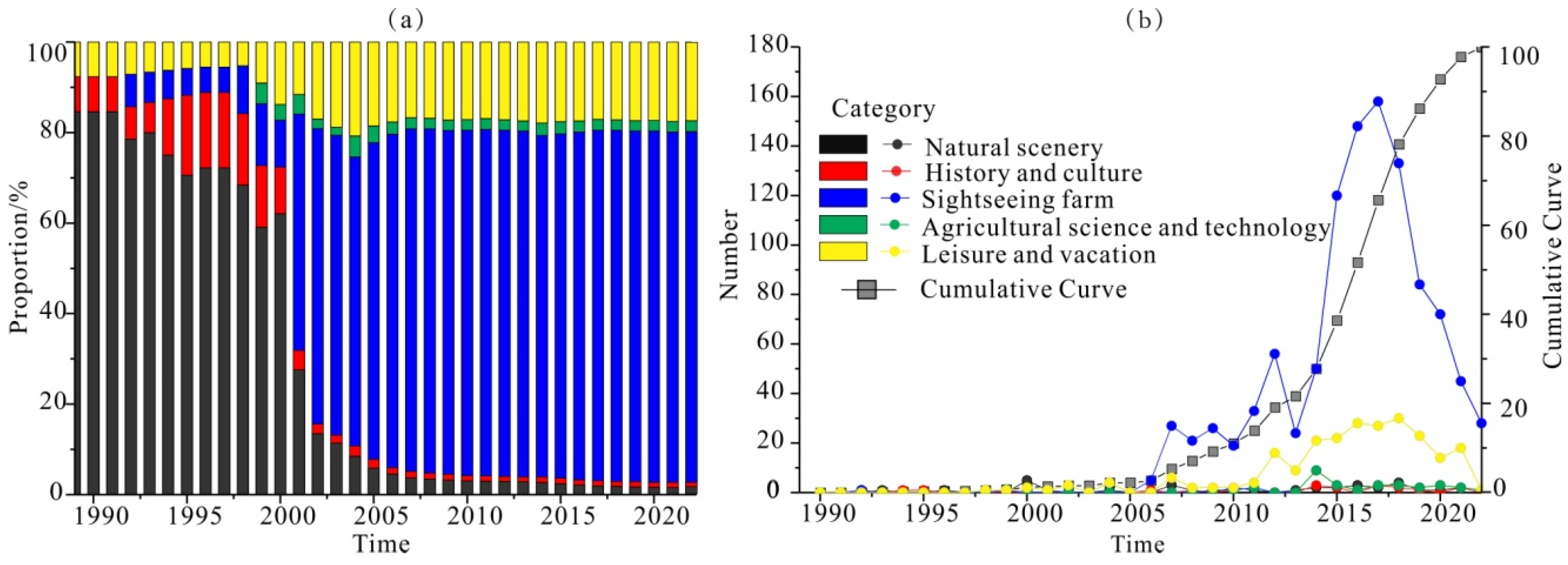
3.1. Structural Characteristics of Rural Tourist Spots in Lanzhou City

There are obvious differences in the internal structure of rural tourism spots in Lanzhou City, which have changed significantly over time. Mainly, the types of rural tourism spots have changed from natural scenery to sightseeing agriculture (Figure 3a). This is because the rural tourist attractions in Lanzhou City have better agricultural conditions based on the diversified natural resources and broad market demand. Furthermore, the change trend of rural tourism resources has been inconsistent (Figure 3b). After 2005, tourism agriculture spots began to grow rapidly, while the number of tourist attractions for leisure and vacation increased in 2010. In 2014, the number of agricultural technology tourist attractions began to increase, and the growth curve showed unstable changes. The increase in the number of historical and cultural rural tourist attractions has been slow, indicating that the allocation ratio of rural tourist attractions in Lanzhou City is not coordinated. A significant change occurred in 2018, when the number of rural tourist attractions reached its peak and gradually declined. This trend reflects the idea that the number of rural tourist attractions in Lanzhou is gradually approaching saturation and the development is gradually stabilizing.

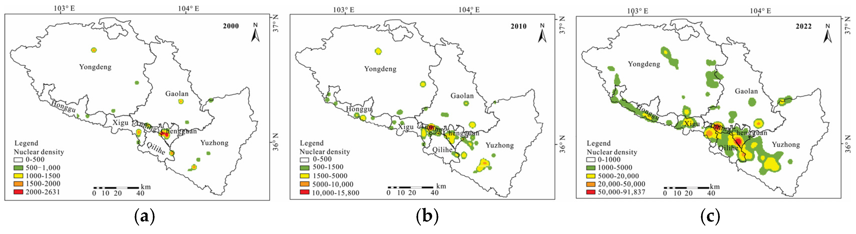
3.2. The Spatial Distribution Range of Rural Tourism Spots in Lanzhou City

The distribution of rural tourism spots in Lanzhou City is uneven, with a higher concentration in the southeastern region and fewer in the northwest (Figure 4a). Over time, these spots have gradually expanded from the central urban area to the surrounding counties, reflecting a growing trend in rural tourism development. In terms of the spatial distribution of different types of rural tourism destinations, leisure and vacation-oriented spots, as well as those focused on history and culture, are predominantly located in Yuzhong County, with relatively fewer such attractions in Honggu District (Figure 4b,d). In contrast, sightseeing farm-based rural tourism spots are mainly concentrated in Chengguan District, followed by Yuzhong County (Figure 4f). Rural tourism focused on agricultural science and technology is primarily found in Gaolan County (Figure 4c), where the emphasis is on integrating modern farming techniques and agricultural innovations. Anning District, however, has a comparatively lower number of agricultural science and technology-related attractions, largely due to its limited agricultural land. Yongdeng County is known for its picturesque natural landscapes and numerous folk culture villages, focusing on developing rural tourism spots centered around natural beauty and historical culture (Figure 4b,e).

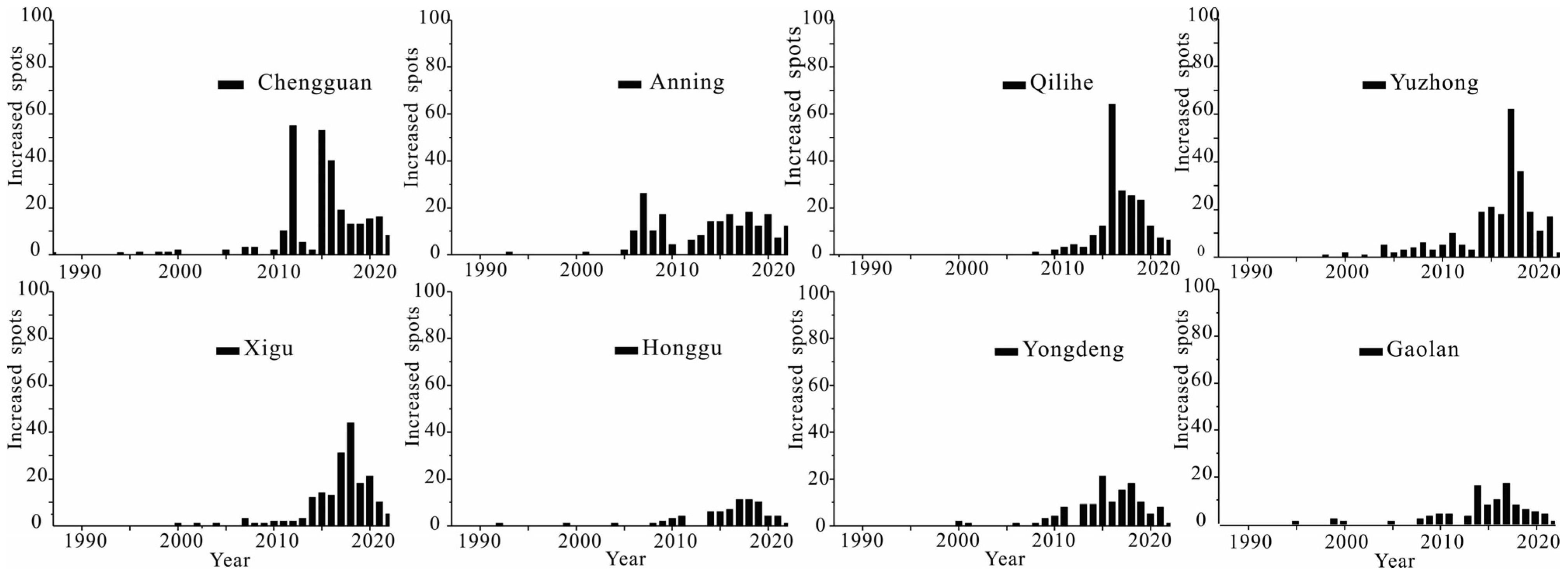
3.3. The Temporal Evolution of Rural Tourism Spots in Lanzhou City

From the perspective of time (Figure 5), the distribution of rural tourist attractions in Lanzhou City has exhibited notable trends across various districts over time. In 2000, rural tourism spots were predominantly concentrated in Chengguan District, which accounted for 35% of the total, followed by Yuzhong County with 20%. This early distribution reflects the proximity to urban centers and high-level tourist attractions, making them more attractive to tourists. From 2000 to 2010, Anning District experienced the fastest growth in rural tourism development, with the increased quantity of rural tourist attractions dramatically from 1 to 70. This growth can be attributed to improved infrastructure, strengthened governmental support, and the promotion of orchard-picking projects in the region. On the other hand, Qilihe District saw the slowest development, with its proportion of rural tourist attractions remaining at a mere 3% of total. Between 2010 and 2022, the growth of rural tourist attractions continued to spread across the city. Chengguan District, still a hub for rural tourism, saw a significant increase of 249 new attractions. This could be due to continued investment in the tourism sector and a strong tourist base. Yuzhong County and Qilihe District also experienced growth, with 224 and 194 new rural tourist attractions, respectively. However, Honggu District and Gaolan County still have a relatively small share of the total spots. The varying growth rates and distribution reflect both the geographical advantages of different districts and the varying levels of governmental investment and infrastructure development.

3.4. Spatial Clustering of Rural Tourism Sites in Lanzhou City

The agglomeration degree is an important index that can be used to reflect the degree of individual correlations among tourism resource groups, and it can reflect the agglomeration degree of individual distributions of tourism resource groups in space. The closest proximity distance was used to analyze the spatial agglomeration degree of rural tourism spots in Lanzhou City, and the results are shown in Table 2. In 2000, the Z-value of rural tourism spots was −3.594728, and the nearest neighbor ratio was 0.667830, which belongs to the aggregation–random distribution. In 2010, the Z-value and nearest neighbor index of the rural tourism spots in Lanzhou City were −13.376095 and 0.377107, which belong to the aggregation distribution. By 2022, the Z-value of rural tourism spots decreased to −49.480735, showing a decreasing trend, which indicates that the rural tourism spots in Lanzhou City have the characteristics of agglomeration and that the agglomeration degree has gradually become enhanced. From 2000 to 2010, the average nearest neighbor distance of rural tourism spots decreased from 5426.32 to 1690.17 m, indicating that the spatial distribution showed a rapid agglomeration feature. In general, the spatial pattern of rural tourism elements in Lanzhou City has changed from agglomeration–random distributions to agglomeration distributions in the past 20 years, and the scope of agglomeration has gradually expanded.

3.5. Spatial Evolution Characteristics of Rural Tourism Spots in Lanzhou City

According to the nuclear density analysis of rural tourism in Lanzhou City (Figure 6), the spatial evolution of the rural tourism industry cluster was analyzed. According to the time span, the evolution process of rural tourism industry agglomeration in Lanzhou City can be divided into three stages.

3.5.1. Embryonic Stage of Rural Tourism in Lanzhou City

Rural tourism in Lanzhou City began in the 1980s, mainly focusing on rural tourism destinations of natural scenery. Shimen Resort, which was established in 1987, was one of the first rural tourist destinations to focus mainly on leisure and vacations. From 1987 to 2000, the spatial distribution pattern of rural tourist attractions in Lanzhou City showed the characteristics of a point-like distribution (Figure 6a). This is because the urbanization level was still low at this stage, the rural tourism market had not been fully launched, and the development of rural tourist attractions was mainly concentrated in the suburbs of the downtown area. Therefore, Chengguan District was the core area, as a result of the phenomenon of rural tourism spot agglomeration. Chengguan District was the earliest area in Lanzhou City to develop rural tourism, as it had the best basic conditions for tourism. The secondary agglomeration points were distributed in Anning District, Xigu District, and Qilihe District. Rural tourist spots scattered in the peripheral counties were located along the Zhuanglang River in Yongdeng County, Xinglong Mountain in Yuzhong County, and Shichuan Town in Gaolan County. The rural tourist spots in Honggu District did not show the characteristics of a random distribution. Generally, there were few cluster points of the rural tourism industry in Lanzhou City at this stage, and the degree of agglomeration was not high. Most of the rural tourism spots showed a random cluster distribution pattern around the natural scenic spots.

3.5.2. Development Stage of Rural Tourism in Lanzhou City

In 2003, early farmhouse tourism appeared in Lanzhou City, mainly in the form of drinking covered bowl tea. In 2006, the farmhouse association was established in Touying Village, Chengguan District, which led to the steady growth of early rural tourism. In the same year, the Lanzhou government pointed out that it would focus on the construction of rural tourism projects, adopt the mode of urban–rural tourism, and open rural tourism. At this stage, rural tourism relied on green scenery and idyllic scenery, combined with leisure farms, rural folk customs, and traditional culture, and the rural tourism industry developed with farmhouse music as the main form. From 2000 to 2010, the distribution pattern of rural tourism spots showed that, with the Yellow River waterway as the axis, the urban area gradually formed a number of cluster points, and the clustering degree was gradually obvious (Figure 6b). Relying on the Renshou Mountain scenic spot, Anning District adopted the mode of sightseeing with picking to vigorously develop rural tourism spots of agricultural experiences and leisure vacations, and it became a new gathering point. Chengguan District relies on Touying Village to carry out leisure and vacation rural tourism, and the degree of this tourism industry cluster has further increased. The neighboring tourist spots in Xigu District, Qilihe District, and Honggu District, driven by the urban area, have explored diversified rural tourism resources such as ecological parks, agricultural ecological parks, and characteristic homestays on the basis of the original leisure and vacation mode. With the radiating effect of urban areas, the rural tourism spots in Lanzhou City form a certain diffusion phenomenon from the center to the periphery, and their spatial distribution shows the characteristics of development from urban areas to counties and towns. The range of rural tourism spots in Gaolan County and Yongdeng County has expanded significantly. The rural tourism spots in Honggu District have increased, showing the characteristics of agglomeration and random distribution initially. The most obvious change occurred at the Yuzhong County agglomeration point. Relying on Xinglong Mountain National Forest Park in Yuzhong County, dozens of rural tourism spots appeared in the surrounding areas; their main business involves farmhouse music, ecological parks, green agriculture, picking parks, and characteristic homestays. Generally, from 2000 to 2010, the rural tourist attractions in Lanzhou City have formed a spatial structure of multiple gathering points.

3.5.3. Rapid Development Stage of Rural Tourism in Lanzhou City

In 2010, the Gansu provincial government issued opinions on accelerating the development of leisure agriculture and rural tourism, and the Lanzhou municipal government issued implementation opinions on accelerating the development of tourism, which put forward the task of increasing the construction of rural tourism and farmhouse entertainment. In 2011, the government made full use of its rural resources to vigorously develop rural tourism and comprehensively expand the functions and fields of agriculture. With the government’s policy to vigorously support the development and construction of rural tourism attractions, the demand for the rural tourism market increased, and the region rushed into a period of rapid development. In 2022, the spatial distribution pattern of rural tourism spots showed that the Chengguan cluster, Anning cluster, and Xinglongshan cluster in Yuzhong County gradually formed in Lanzhou City (Figure 6c). The scale and scope of the agglomeration points have been further expanded, and the degree of agglomeration has been significantly improved. Secondly, with the development and construction of the Lanzhou New Area, the agglomeration point of the Lanzhou New Area was formed. In addition to the traditional leisure and ecological tourist attractions, the agglomeration point also integrates the surrounding urban–rural combination tourist attractions, such as wetland parks and a dinosaur paradise. In addition, the Datong River gathering point in Yongdeng County, with Turugou National Forest Park as the core, had a large number of farmhouse characteristics and those of other industries and has been upgraded to a new primary gathering point. In general, the spatial distribution characteristics of rural tourist attractions are characterized by the transfer of urban core areas to counties and towns, and the distribution tends to expand in the west and east along the Yellow River. Combined with the characteristics of the distribution of tourist attractions, the transportation lines, the river network, and the development status, Lanzhou City has formed a “one-axis multi-core” spatial distribution structure of rural tourism spots. That is, by relying on the Yellow River waterway and highway rural leisure tourism development axis, with the Chengguan–Aning–Yuzhong agglomeration area as the core (Figure 6c), the surrounding rural tourism agglomeration points have been connected. These include the XiguHekou Ancient Town agglomeration point, Yongdeng County Zhuanglang River agglomeration point, Yongdeng County Datong River agglomeration point, Gaolan County Shichuan Town agglomeration point, Lanzhou New Area agglomeration point, etc. The rural tourism resources of Lanzhou City have gradually realized the transformation of rural tourism industry agglomerations from agricultural experiences to leisure and vacations. The development mode of rural tourism industry agglomerations has transformed from resource-based to human-centered scenic spots and tourism elements.

4. Discussion

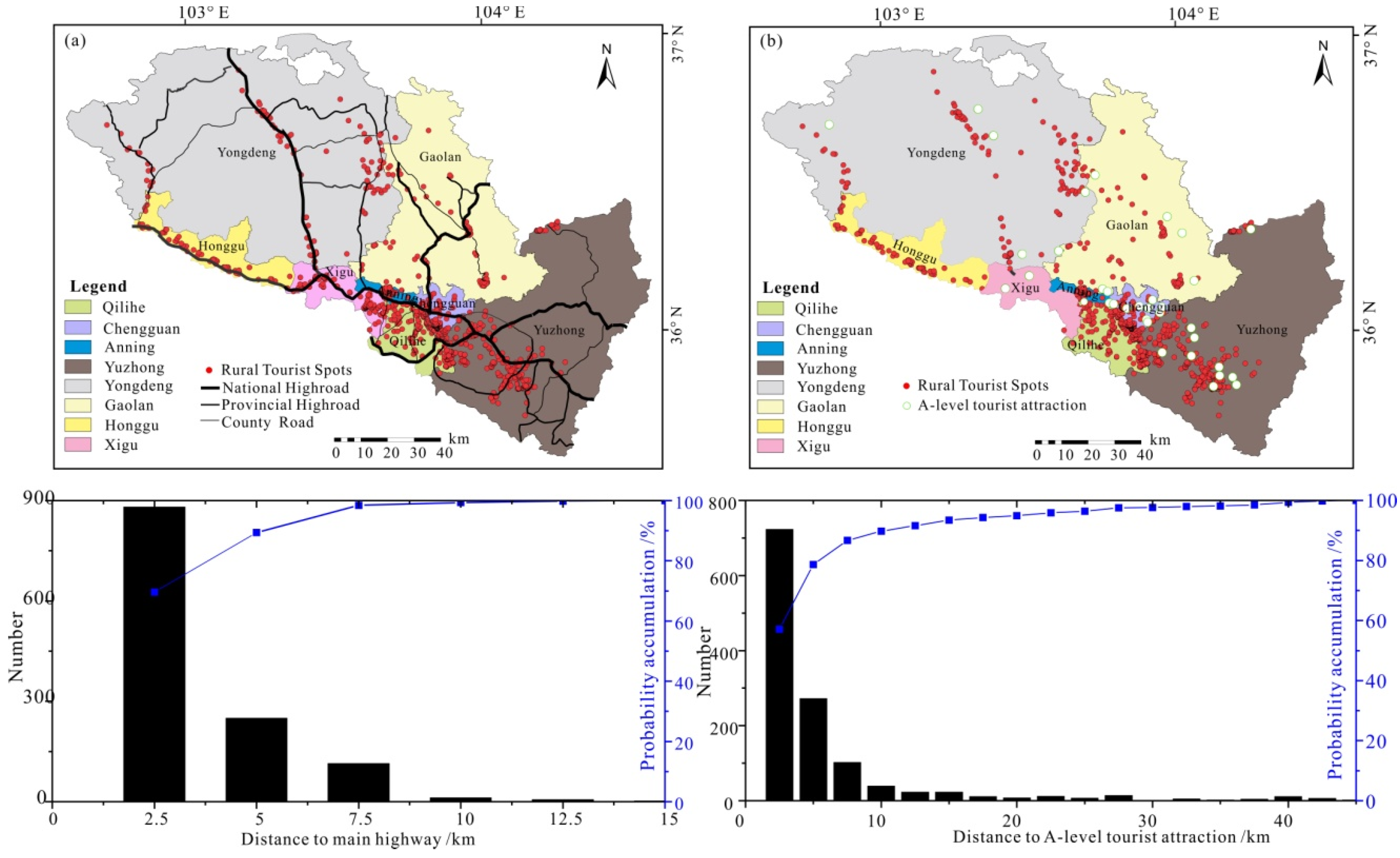
4.1. The Influence of Natural Factors on the Spatial Distribution Pattern of Rural Tourist Spots

Tourism industry agglomerations are influenced by multiple factors [45]. Lanzhou City is located in the ecologically fragile northwest area, and is covered by loess hills and basins, so the spatial distribution of rural tourism spots is obviously restricted by natural geographical factors. With an increase in altitude, the quantity of rural tourism spots showed a decreasing trend. More than 90% of the rural tourism sites were distributed in the elevation range from 1418 m to 2100 m (Figure 7a). The number of rural tourist spots at the altitude of 1550 m reached the peak, which is because of the river valley’s height being from 1500 m to 2000 m. This relatively flat terrain is suitable for agriculture, and agricultural economic activity has been frequent since ancient times. Therefore, it is suitable for carrying out farm experience projects, such as picking gardens, plantations, fishing parks, etc. As the altitude increases, there are scattered rural tourist attractions between 2000 m and 2500 m (Figure 7b). The main tourist attractions gathered in this area are natural scenic spots, such as Turu Valley Forest Park, Shifo Valley Forest Park, Lanshan Forest Park, Xujiashan Forest Park, Xinglong Mountain Forest Park, and so on. Areas above 2500 m are restricted by the terrain, inconvenient transportation, and insufficient space for rural tourism activities, and rural tourism does not have the characteristics of agglomeration distribution.
Lanzhou City is the only city where the Yellow River passes through. Relying on the natural water system, Lanzhou City developed the Waterwheel Expo Park, Qinwangchuan Wetland Park, and other natural scenic spots. It also developed rural tourism projects such as boating, fishing, and rafting. Using a buffer zone analysis, the water area was continuously buffered with an incremental step of 2.5 km, and the number of rural tourism points in each buffer area was calculated; thus, the correlation between rural tourism points and water elements in Lanzhou City was obtained (Figure 7c). The results show that the number of rural tourist spots decreases rapidly with an increase in distance from the water area, showing obvious hydrophilic characteristics. About 47% of the rural tourism spots are clustered within 5 km of the water area, and about 73% are clustered within 10 km of the water area, which is the most concentrated and intensive area for rural tourism development in the region. The Yellow River is rich in tourism resources, which are effectively combined with the development of rural tourism resources to form rich and diversified rural tourism management projects such as farmhouse music, ecological parks, and characteristic homestays. Consequently, the cluster points along the Zhuanglang River and the Datong River in Yongdeng County directly benefit from the advantageous radiation of the Yellow River system.

4.2. The Influence of Economic Factors on Spatial Distribution Patterns of Rural Tourism Spots

The main transportation mode of rural tourism is self-driving; thus, good traffic conditions can promote the circulation of tourism elements and greatly reduce the travel time of tourists [46]. Based on the main highway in Lanzhou City, multistage buffer rows with intervals of 2.5 km were established on both sides of the highway for a superposition analysis, and the number of rural tourism points within the buffer zone was counted. The number of rural tourism points within 2.5 km was 881, accounting for 69.6% (Figure 8a). Within 5 km, the number of rural tourism points was 1131, accounting for 89.4% and indicating that the rural tourism points have the spatial distribution characteristics of the highway. For example, National Highroad 312 connects Chengguan District, Anning District, Yuzhong County, and Yongdeng County. All the rural tourist attractions are within 2.5 km of Chengguan District, and the highroad accessibility accelerates the concentration of Chengguan District. The scenic spots far away from the main highway are distributed in Honggu District, Gaolan County, and Yongdeng County. The main reason for this is that the transportation infrastructure in these areas is relatively weak, and the accessibility of roads needs to be further improved.
Based on the A-level scenic spots in Lanzhou City, the number of rural tourist spots in the buffer zone of different distances was calculated (Figure 8b). With increasing distance, the number of rural tourist spots showed a decreasing trend. Among them, the number of rural tourist spots within 0–2.5km was the largest, at up to 723, accounting for 57.2% of the total. The number of rural tourist spots ranging from 0 to 5 km was 994, accounting for 78.7%. The number of rural tourism spots greater than 20km was less than 10, which indicates that the rural tourism spots in Lanzhou City are closely related to the distribution of A-level scenic spots. A-level scenic spots have the advantages of a perfect infrastructure, a good brand effect, and high tourism attraction, which can promote the level of tourism growth and drive the construction of surrounding rural tourist spots through the multiplier effect.
From the perspective of the model, farm holidays were regarded as an early modern type of rural tourism product [47]. With tourism growth, rural tourism activities have also transformed and diversified into a complex, multifaceted business. Culture and heritage culture are important resources for rural tourism, and an important part of the field is the enjoyment of the rural ways of life as a form of cultural experience [48]. From 2010 to 2022, the historical and cultural categories of rural tourism sites have grown rapidly, which is because of the development of folk culture resources. Relying on the construction of nationally famous historical and cultural towns and villages, Qingcheng Ancient in Yuzhong County, Jinya Town in Yuzhong County, Yongdenglian Town in Yongdeng County, Hongcheng Town in Yongdeng County, and Hekou Town in Xigu District have respectively formed rural tourism gathering points. With the development of smart tourism and the combination of traditional culture and modern agricultural science and technology development, the number of agricultural science and technology rural tourism spots in Lanzhou City has increased from 3 to 29. Projects such as agricultural demonstration parks, garden complexes, and agricultural museums have become new man-made rural tourist attractions, broadening the tourism elements of the rural tourism industry chain. Furthermore, the development of rural tourism can be divided into three phases: farm holidays, activity tourism, and destinations [49]. Rural tourism in Lanzhou City is still in the initial stage of the second phase. Compared with eastern China, the period of a rapid cluster of rural tourism spots in Lanzhou City was from 2012 to 2017 and was relatively slow for 5–10 years. Consequently, economic constraints and the issuance of policy planning play an important role in guiding and regulating the evolution of rural tourism in Lanzhou City.

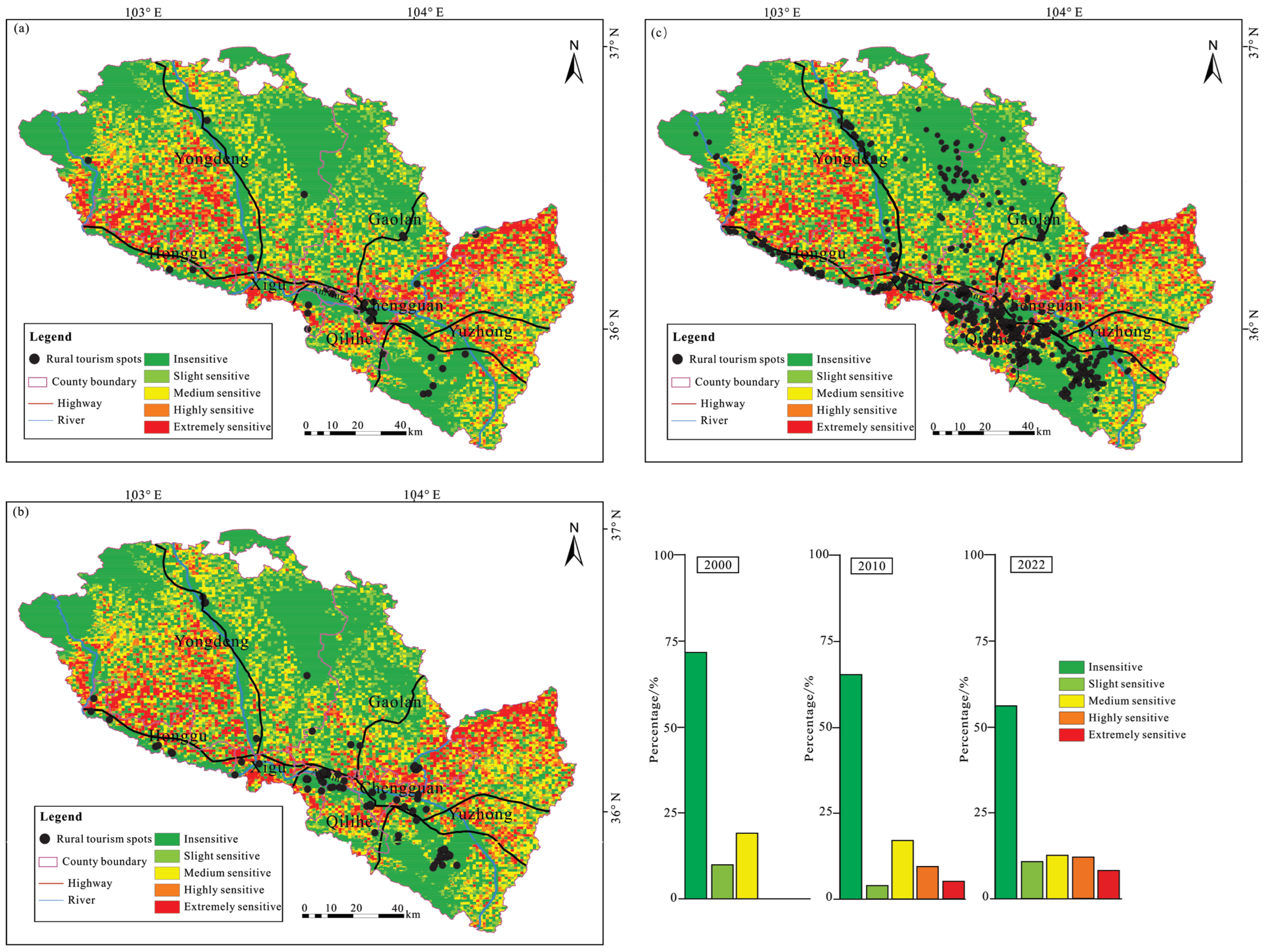
4.3. The Impact of the Expansion of Rural Tourism Spots on the Ecological Environment

A contradiction in the development of tourism is concentrated between economic promotion and ecological sustainability [50]. Multiple indicators were used to measure and simulate the impact of tourism activities on destinations [51,52]. Land provides the material foundation and carrying space for tourism activities, playing an irreplaceable and important role in regulating and controlling the spatial development of the tourism industry. Initially, rural tourism was significantly constrained by land quality and agricultural suitability [53]. However, the process of reshaping the spatial structure of tourism systems through socio-economic factors has now been enhanced [54]. The transformation of the land use function structure in rural tourism areas is the result of the combined effects of natural resources, the policy environment, and tourism activities on the rural territorial system [55]. Although the rural areas in the mountainous regions of western China are vast, the available land space is limited and fragmented after excluding cultivated land, forest protection areas, ecological protection zones, and village homesteads. Therefore, the development of rural tourism in Lanzhou City will inevitably lead to an intensification of the land conflict between urban and rural areas.
Between 2000 and 2010, land use in Lanzhou City underwent significant changes. The proportion of construction land increased from 3.27% to 3.58%, while cultivated land declined from 28.4% to 27.9%. Rural tourism development contributed to notable shifts in land patterns (Figure 9), with the proportion of rural tourism occupying agricultural land rising from 28.7% to 34.9%. Additionally, rural tourism increasingly emerged in water areas and undeveloped land. From 2010 to 2022, construction land further increased from 3.58% to 6.11%, while cultivated land decreased from 27.9% to 26.43%, reflecting a growing trend of irrational land use. The proportion of grassland and forest land occupied by rural tourism increased, whereas the proportion of construction land decreased (Figure 9). This is because Lanzhou City is dominant low-relief mountainous terrain, and the suburban expansion of rural tourism leads to a predominance of grassland use in rural tourism sites. Overall, grassland has been the primary land use type for rural tourism development in Lanzhou City, followed by cultivated land, which indicates insufficient land use diversity in rural tourism development from 2000 to 2022.
In China, coordinating land use for mountainous rural tourism with ecological protection remains challenging. On the one hand, with the implementation of policies such as the National Tourism and Leisure Outline (2013–2020), intensified rural tourism development has increased the demand for tourism land. Most mountainous areas in central and western China are ecologically fragile. Steep forested and grassland areas are unsuitable for development, while gentle slopes are densely populated, creating conflicts between urban–rural construction and tourism land expansion [56]. Moreover, unique land policies lead to fragmented land ownership in mountainous areas, making it difficult to acquire land for composite tourism projects, and large-scale tourism land transactions entail high contractual costs [57]. Tourism land is classified into different types, each governed by different administrative departments. While this policy improves efficiency, it also results in fragmented management. Particularly in rural tourism areas and small-scale projects such as leisure tourism sites, obstacles to agricultural land leasing and transfer, or low agricultural land lease prices, further intensify urban–rural land use conflicts.
In order to more comprehensively understand the ecological issues in the evolution of rural tourism destinations, a series of indicators, including the elevation, slope, vegetation coverage, and land use type, were selected to generate an environmental sensitivity distribution map based on weighted factors (Figure 10). The results showed that, in 2000, rural tourism destinations in Lanzhou City were mainly concentrated in insensitive areas (71.4%), followed by moderately sensitive areas and lightly sensitive areas, with no distribution in highly sensitive areas (Figure 10a). By 2010, rural tourist attractions in Lanzhou City were still mainly distributed in insensitive areas (65%), but 8.5% and 5.3% were accounted for by highly sensitive and extremely sensitive areas, respectively (Figure 10b). The proportion of rural tourism sites located in insensitive areas decreased to 56% in 2022, while the number of rural tourism sites in highly sensitive and extremely sensitive areas rapidly increased to 12% and 8%, respectively (Figure 10c). In terms of regional distribution, Chengguan District in Lanzhou City has the highest proportion of rural tourist attractions located in sensitive areas, at 61.2%. From this, it can be seen that the spatial distribution of rural tourism destinations in Lanzhou City has a negative effect on the ecological environment. To a certain extent, the rapid development of rural tourism points hinders ecological environmental construction.

5. Conclusions

Based on the statistics of rural tourist spots in Lanzhou City from 1987 to 2022, this study analyzed the spatial distribution pattern and evolution of rural tourist spots in Lanzhou City. The development of rural tourism was slow from 2000 to 2010, with tourism spots scattered and randomly distributed. Between 2010 and 2022, rural tourism grew rapidly, showing significant clustering. The distribution followed a multi-core, axis-based pattern, influenced by terrain, water conditions, main highways, and A-class scenic spots. Economic and policy factors led to an expansion from the city center to the suburbs, with uneven development across different regions. Furthermore, based on global studies on rural tourism in impoverished mountain areas and Lanzhou’s specific conditions, this study considers the role of socio-economic dynamics, community participation, and local governance and proposes the following development pathways:
(1)
Constructing a Tourism Growth Axis Along the Yellow River: Lanzhou should develop a tourism growth axis centered around the Yellow River, supported by multiple transportation corridors to promote regional advantage diffusion and balanced development. To enhance the core competitiveness of Lanzhou’s rural tourism clusters, the government should integrate Yellow River cultural heritage into tourism, fostering deep cultural–tourism integration and forming a distinctive Yellow River-themed tourism cluster. Establishing historical and cultural tourism clusters and leveraging their spillover effects can drive tourism growth in surrounding areas. Rural tourism development relies on effective spatial planning and coordinated resource allocation [14]. Particularly, developing rural tourism destinations centered on local culture can significantly promote resource integration within the region [58]. Through this strategy, Lanzhou can facilitate the flow of resources from the urban center to surrounding rural areas, boost rural economic development, and strengthen urban–rural connectivity.
(2)
Enhancing Community Participation and Local Governance:Global research on rural tourism highlights community participation as a key factor for sustainable tourism development [59]. Local governments should strengthen engagement and cooperation with local communities to ensure residents’ involvement and benefit-sharing in tourism planning and implementation [60]. Effective local governance can prevent tourism development dominated by external capital from disrupting local social structures and cultural heritage [61]. As Lanzhou promotes rural tourism, it should establish transparent decision-making mechanisms and community participation platforms to enable residents to play a greater role in tourism projects while safeguarding their economic interests and social well-being.
(3)
Balancing Rural Tourism Development and Ecological Sustainability:While rural tourism supports poverty alleviation in mountainous areas, it also reshapes traditional living spaces, inevitably leading to challenges such as ecological degradation and resource overexploitation [38]. Therefore, the Lanzhou government should implement targeted policies, such as ecological compensation mechanisms and resource recycling strategies, to ensure the coordinated development of production, living, and ecological spaces in rural areas. To prevent excessive deforestation and ecological degradation, greater protection should be enforced in ecologically fragile regions. Different types of villages, including impoverished, characteristic, and central villages, require targeted tourism poverty alleviation policies. Based on local conditions, differentiated clustering strategies, such as relocation and scenic area consolidation, should be adopted to optimize the spatial layout of rural tourism destinations and create an integrated rural living circle [62].
By analyzing the spatial distribution characteristics and dynamic evolution of rural tourism resources in Lanzhou City, this study identifies key factors influencing the distribution of rural tourism resources in ecologically fragile areas. The findings provide practical implications for tourism-driven poverty alleviation and the sustainable development of rural tourism resources in mountainous regions. However, future research can further refine this study in the following aspects: (1) Rural tourism presents spatial disparities, requiring comparative analyses of other ecologically fragile regions to understand the mechanisms behind rural tourism spatial restructuring and driving factors. (2) Rural tourism is influenced not only by spatial organization but also by socio-economic dynamics, governance structures, and community participation levels. Future studies should focus on local governance and community participation, examining residents’ influence in tourism development and establishing collaborative mechanisms between local governments and communities. (3) Exploring the relationship between rural tourism-driven economic growth and ecological sustainability, particularly at the micro-scale level of tourism clusters or rural communities, can provide deeper insights.
Overall, rural tourism destinations in ecologically fragile areas face dual pressures of ecological sustainability and economic growth. By examining the spatial evolution and driving mechanisms of rural tourism in Lanzhou City, the ideas, methods, and findings of this study offer valuable case studies for rural tourism development in other ecologically fragile regions.

Author Contributions

Investigation, H.P., J.Z. and Y.L.; Writing—original draft, H.P. and J.Z.; Writing—review & editing, H.P. and Y.L. All authors have read and agreed to the published version of the manuscript.

Funding

This work was supported by the National Natural Science Foundation of China (Grant No.: 42001004).

Institutional Review Board Statement

Not applicable.

Informed Consent Statement

Not applicable.

Data Availability Statement

The original contributions presented in the study are included in the article; further inquiries can be directed to the corresponding author.

Conflicts of Interest

The authors declare no conflict of interest.

References

  1. Rosalina, P.D.; Dupre, K.; Wang, Y. Rural tourism: A systematic literature review on definitions and challenges. J. Hosp. Tour. Manag. 2021, 47, 134–149. [Google Scholar] [CrossRef]
  2. Fotiadis, A.; Nuryyev, G.; Achyldurdyyeva, J.; Spyridou, A. The impact of EU sponsorship, size, and geographic characteristics on rural tourism development. Sustainability 2019, 11, 2375. [Google Scholar] [CrossRef]
  3. Nooripoor, M.; Khosrowjerdi, M.; Rastegari, H.; Sharifi, Z.; Bijani, M. The role of tourism in rural development: Evidence from Iran. GeoJournal 2020, 86, 1705–1719. [Google Scholar] [CrossRef]
  4. Ryu, K.; Roy, P.A.; Kim, H.; Ryu, H. The resident participation in endogenous rural tourism projects: A case study of Kumbalangi in Kerala, India. J. Travel Tour. Mark. 2020, 37, 1–14. [Google Scholar] [CrossRef]
  5. Kortoci, Y.; Kortoci, M. The assessment of the rural tourism development in the Valbona Valley National Park. Tour. Econ. 2017, 23, 1662–1672. [Google Scholar] [CrossRef]
  6. Su, M.M.; Wall, G.; Wang, Y.; Jin, M. Livelihood sustainability in a rural tourism destination -Hetu Town, Anhui Province, China. Tour. Manag. 2019, 71, 272–281. [Google Scholar] [CrossRef]
  7. Lorren, K.H.; Karen, N.; Gift, D.; Tondani, N.; Fhatuwani, S. An assessment for enhancing sustainability in rural tourism products in South Africa. Dev. South. Afr. 2020, 37, 1033–1050. [Google Scholar]
  8. Thomas, I.; Frankhauser, P.; Biernacki, C. The morphology of built-up landscapes in Wallonia (Belgium): A classification using fractal indices. Landsc. Urban Plan. 2008, 84, 99. [Google Scholar] [CrossRef]
  9. Streifeneder, T. Agriculture first: Assessing European policies and scientific typologies to define authentic agritourism and differentiate it from countryside tourism. Tour. Manag. Perspect. 2016, 20, 251–264. [Google Scholar] [CrossRef]
  10. Beenstock, M.; Felsenstein, D. Marshallian theory of regional agglomeration. Pap. Reg. Sci. 2010, 39, 155–172. [Google Scholar] [CrossRef]
  11. Lee, S.H.; Choi, J.Y.; Yoo, S.H.; Oh, Y.G. Evaluating spatial centrality for integrated tourism management in rural areas using GIS and network analysis. Tour. Manag. 2013, 34, 14–24. [Google Scholar] [CrossRef]
  12. Panzer-Krause, S. The lost rural idyll? Tourists’ attitudes towards sustainability and their influence on the production of rural space at a rural tourism hotspot in Northern Ireland. J. Rural Stud. 2020, 80, 235–243. [Google Scholar] [CrossRef]
  13. Durydiwka, M. Tourist function in rural areas of Poland. Spacial diversity and changing trends. Misc. Geogr. Reg. Stud. Dev. 2013, 17, 5–11. [Google Scholar] [CrossRef]
  14. Lafferty, G.; Fossen, A.V. The role of clusters in preventing tourism decline: A conceptual and empirical examination. Int. J. Serv. Technol. Manag. 2005, 6, 142. [Google Scholar] [CrossRef]
  15. Michael, E.J. Tourism micro-clusters. Tour. Econ. 2003, 9, 133–145. [Google Scholar] [CrossRef]
  16. Rodríguez-Victoria, E.; Puig, F.; González-Loureiro, M. Clustering, innovation and hotel competitiveness: Evidence from the Colombia destination. Int. J. Contemp. Hosp. Manag. 2017, 11, 2785–2806. [Google Scholar] [CrossRef]
  17. Namhyun, K.; Changsup, S. Social capital, knowledge sharing and innovation of small and medium-sized enterprises in a tourism cluster. Int. J. Contemp. Hosp. Manag. 2018, 6, 2417–2437. [Google Scholar]
  18. Tchetchik, A. An optimal size for rural tourism villages with agglomeration and congestion effects. Eur. Rev. Agric. Econ. 2012, 39, 685–706. [Google Scholar] [CrossRef]
  19. Huang, X.J.; Zhang, K.; Wang, H.J.; Xiong, Z.Y.; Hu, B. Can rural tourism reduce the urban-rural income gap?—Empirical evidence from “national leisure agriculture and rural tourism demonstration counties”. Tour. Trib. 2023, 38, 16–29. [Google Scholar]
  20. Wang, W.; Zhang, B.; Xu, J.; Ren, Y. Research on the development and construction of rural cultural tourism resources based on the “Point axis” Theory. J. Qual. Assur. Hosp. Tour. 2023, 1–16. [Google Scholar] [CrossRef]
  21. Zhang, Y.G.; Hao, Y.M.; Guo, Y.Z. Regional imbalance of rural tourism development from the perspective of common prosperity: Theoretical connotation, key issues and measurement system. J. Nat. Resour. 2023, 38, 403–418. [Google Scholar] [CrossRef]
  22. Liu, C.X.; Tang, D.J.; Chang, J.J. Research on space-time evolution and mechanism of the rural tourism industrial aggregation in Hangzhou City: Based on the perspective of social capital. Agric. Econ. Probl. 2015, 36, 35–43. [Google Scholar]
  23. Gao, P.; Xi, J.C. Tourism industry agglomeration and mechanisms for rural settlements of Gouge Village in Yesanpo, Hebei Province. Resour. Sci. 2017, 39, 1535–1544. [Google Scholar]
  24. Hao, J.L.; Guan, W.; Wang, L.; An, X.S.; Sun, F.K.; Wu, L. Spatial pattern optimization and spatial expansion of tourism industry based on network analysis method: Take Dalian as an example. Resour. Environ. Yangtze Basin 2020, 29, 2177–2185. [Google Scholar]
  25. Yu, R.Z.; Zhang, Y.G.; Yu, X.Y. Research on the configuration and path of influencing factors of rural tourism destination development: Qualitative comparative analysis based on 17 rural tourism destination cases. Econ. Geogr. 2021, 41, 225–231. [Google Scholar]
  26. Wu, B.H. Spatial structure of rural tourism attractions in Suburban Areas of China. Sci. Geogr. Sin. 2004, 24, 757–763. [Google Scholar]
  27. Xu, Q. Research on spatial agglomeration of tourism based on the “Pole-Axis System” Theory—A case study of Jiangshan in Zhejiang Province. Econ. Geogr. 2013, 33, 174–178. [Google Scholar]
  28. Zhang, Y.; Li, W.; Li, Z.; Yang, M.; Zhai, F.; Li, Z.; Yao, H.; Li, H. Spatial distribution characteristics and influencing factors of key rural tourism villages in China. Sustainability 2022, 14, 14064. [Google Scholar] [CrossRef]
  29. Liu, S.H.; Liang, M.Z. Development path of tourism agglomeration in recreational belt around urban agglomeration of the Greater Pearl River Delta: A case study of tourism section for coastalregion and mountain area in Guangdong Province. Econ. Geogr. 2015, 35, 190–197. [Google Scholar]
  30. Sofield, T.; Lacy, T.D.; Lipman, G.; Daugherty, S. Sustainable Tourism-Eliminating Poverty (ST-EP): A Overview; CRC for Sustainable Tourism Pty Ltd.: Gold Coast, Australia, 2004; pp. 1–10. [Google Scholar]
  31. Sharpley, R. Poverty alleviation through tourism: A comprehensive and integrated approach. Tour. Manag. 2016, 56, 207–208. [Google Scholar] [CrossRef]
  32. Cai, J.J.; Wu, X. Effects of rural tourism on the livelihood of poor farmers from the perspective of social-ecosystem vulnerability: A case study of Beixi Village, yongchun county, Fujian province. Taiwan Agric. Res. 2018, 2, 9–17. [Google Scholar]
  33. Long, H.; Tu, S. Rural restructuring: Theory, approach and research prospect. Acta Geogr. Sin. 2017, 72, 563–576. [Google Scholar]
  34. Yang, R.; Liu, Y.; Long, H.; Zhang, Y. Research progress and prospect of rural transformation and reconstruction in China: Paradigms and main content. Prog. Geogr. 2015, 34, 1019–1030. [Google Scholar]
  35. Liu, Y.S.; Yan, B.; Wang, Y.F. Urban-rural development problems and transformation countermeasures in the new period in China. Econ. Geogr. 2016, 36, 655–666. [Google Scholar]
  36. Zhou, X.L.; Wang, Z.C.; Liu, Y.Z.; Cheng, Y.Q.; Zhou, Y.M.; Zhang, J.P. Factors influencing the evolution of rural settlements based on MGWR: A case study of Haikou City. Trop. Geogr. 2023, 43, 1599–1610. [Google Scholar]
  37. Lin, M.S.; Xiao, X.N.; Xu, Y.; Xie, H.B. The impact of water quality changes on tourism capacity at golden lake, China. J. Food Agric. Environ. 2013, 11, 1069–1072. [Google Scholar]
  38. Gong, Z.; Liu, W.; Guo, J.; Su, Y.; Gao, Y.; Bu, W.; Ren, J.; Li, C. How to achieve the ecological sustainability goal of ecologically fragile areas on the Qinghai-Tibet Plateau: A multi-scenario simulation of Lanzhou-Xining urban agglomerations. Land 2024, 13, 1730. [Google Scholar] [CrossRef]
  39. Wu, K.; Wu, M.; An, Z.; Jiao, H. Evaluation of tourism ecological security and its obstacles in semi-arid river valley urban: A case study of Lanzhou, China. Sci. Rep. 2025, 15, 3943. [Google Scholar] [CrossRef]
  40. Tang, C.L.; Guo, X.S.; Zhou, G.H.; Wu, J.M.; Chen, W.Y. Spatial distribution and influencing factors of innovation platform in urban agglomeration in the middle reaches of the Yangtze River. Prog. Geogr. 2020, 39, 531–541. [Google Scholar] [CrossRef]
  41. Liu, L.; Jiang, C.; Zhou, S.H.; Liu, K.; Xu, C.; Cao, J.J. Multi-scales patio-temporal pattern analysis of urban burglary crime: A case study of DP Peninsula in H City, China. Geogr. Res. Aust. 2017, 36, 2451–2464. [Google Scholar]
  42. Lu, Y.Q. The scientific connotation of pole-axis theory. Sci. Geogr. Sin. 2002, 22, 136–143. [Google Scholar]
  43. Zhong, L.S.; Zeng, Y.X.; Xiao, L.L.; Zhao, D. Spatial characteristics of tourism resources and the development pattern in jurisdiction of Hulunbuir Agricultural Reclamation Group. Chin. Sci. Bull. 2018, 63, 1740–1751. [Google Scholar] [CrossRef]
  44. Shu, R.; Xiao, J.; Yang, Y.; Kong, X. The evolution of spatiotemporal patterns and influencing factors of high-level tourist attractions in the Yellow River Basin. Front. Earth Sci. 2023, 11, 1206716. [Google Scholar]
  45. Wang, X.; Xi, J.; Yang, D.; Chen, T. Spatial differentiation of rural touristization and its determinants in China: A geo-detector-based case study of Yesanpo scenic area. J. Resour. Ecol. 2016, 7, 464–471. [Google Scholar]
  46. Chen, Z.; Liu, Y.; Feng, W.; Li, Y.; Li, L. Study on spatial tropism distribution of rural settlements in the Loess Hilly and Gully Region based on natural factors and traffic accessibility. J. Rural Stud. 2019, 93, 441–448. [Google Scholar] [CrossRef]
  47. Jennings, G.; Kim, K.; McGehee, N.G. Gender and motivation for agri-tourism entrepreneurship. Tour. Manag. 2007, 28, 280–289. [Google Scholar]
  48. Kastenholz, E.; Carneiro, M.J.; Marques, C. Marketing the rural tourism experience. In Strategic Marketing in Tourism Services; Tsiotsou, R.H., Goldsmith, R.E., Eds.; Emerald Publishing: Bradford, UK, 2012; Volume 16, pp. 247–264. [Google Scholar]
  49. Lane, B.; Elisabeth, E. Rural tourism: The evolution of practice and research approaches towards a new generation concept? J. Sustain. Tour. 2015, 23, 1133–1156. [Google Scholar] [CrossRef]
  50. Neel, C.W.; Dilnu, C.W.; Prabuddh, K.M.; Kamal, A.; Vishal, M.; Mohammed, S.F. An ecotourism suitability index for a world heritage city using GIS-multi criteria decision analysis techniques. Heliyon 2024, 10, e31585. [Google Scholar]
  51. Tang, C.; Han, Y.; Ng, P. Green consumption intention and behavior of tourists in urban and rural destinations. J. Environ. Plan. Manag. 2022, 66, 2126–2150. [Google Scholar] [CrossRef]
  52. Pathmanandakumar, V.; Goh, H.C.; Chenoli, S.N. Identifying potential zones for ecotourism development in Batticaloa district of Sri Lanka using the GIS-based AHP spatial analysis. GeoJ. Tour. Geosites 2023, 46, 252–261. [Google Scholar] [CrossRef]
  53. Sevenant, M.; Antrop, M. Settlement models, land use and visibility in rural landscapes: Two case studies in Greece. Landsc. Urban Plan. 2007, 80, 362–374. [Google Scholar] [CrossRef]
  54. Ayhan, Ç.K.; Taşlıa, T.C.; Özkökb, F.; Tatlıc, H. Land use suitability analysis of rural tourism activities: Yenice, Turkey. Tour. Manag. 2020, 76, 103949. [Google Scholar] [CrossRef]
  55. Long, H.L. Land use transition and rural transformation development. Prog. Geogr. 2012, 31, 131–138. [Google Scholar]
  56. Zhu, D.G.; Xie, B.G.; Cheng, Y.L. The strategy of tourism land in mountain tourism city based on evalution of ecological sensitivity- A Case study of Zhangjiajie city. Econ. Geogr. 2015, 35, 184–189. [Google Scholar]
  57. Tu, S.S.; Long, H.L.; Zhang, Y.N.; Ge, D.Z.; Qu, Y. Rural restructuring at village level under rapid urbanization in metropolitan suburbs of China and its implications for innovations in land use policy. Habitat Int. 2018, 77, 143–152. [Google Scholar] [CrossRef]
  58. Kazemiyeh, F.; Sadighi, H.; Chizari, M. Investigation of rural tourism in East Azarbaijan Province of Iran utilizing SWOT Model and Delphi Technique. J. Agric. Sci. Technol. 2016, 18, 911–923. [Google Scholar]
  59. Popescu, C.A.; Iancu, T.; Popescu, G.; Croitoru, I.M.; Adamov, T.; Ciolac, R. Rural tourism in mountain rural comunities- possible direction/strategies: Case study mountain area from Bihor County. Sustainability 2024, 16, 1127. [Google Scholar] [CrossRef]
  60. Kelfaoui, A.; Rezzaz, A.M.; Kherrour, L. Revitalization of mountain rural tourism as a tool for sustainable local Development in Kabylie (Algeria). GeoJ. Tour. Geosites 2021, 34, 112–125. [Google Scholar]
  61. Ashley, C.; Roe, D. Making tourism work for the poor: Strategies and challenges in southern Africa. Dev. South. Afr. 2002, 19, 61–82. [Google Scholar] [CrossRef]
  62. Wang, Y.; Liu, Z. Sustainable Development of rural tourism in ecologically fragile areas: Lessons from the Loess Plateau. Sustainability 2020, 12, 2345. [Google Scholar]
Figure 1. The geographical location of Lanzhou City in China (a) and landform types in Lanzhou City (b).
Sustainability 17 03618 g001
Figure 2. Theoretical framework.
Sustainability 17 03618 g002
Figure 3. Structure of rural tourism spots in Lanzhou City from 1987 to 2022 (a). Trend chart for different types of rural tourism spots over time (b).
Sustainability 17 03618 g003
Figure 4. Spatial distribution of categorized rural tourism spots in Lanzhou City (a). History and culture category (b), agricultural science and technology category (c), leisure and vacation category (d), national scenery category (e), and sightseeing farms category (f).
Sustainability 17 03618 g004
Figure 5. Change trend of rural tourist spots in Lanzhou City.
Sustainability 17 03618 g005
Figure 6. Kernel density of rural tourism spots in 2000 (a), 2010 (b), and 2022 (c).
Sustainability 17 03618 g006
Figure 7. Combination diagram of rural tourism spots and geographical elements in Lanzhou City (a). Distribution statistics of elevation for rural tourism spots (b). Distribution statistics of distance between rural tourism points and drainage (c).
Sustainability 17 03618 g007
Figure 8. The relationship between rural tourist spots and transportation elements in Lanzhou City. Distribution statistics of rural tourism spots along roads (a). Classification statistics of distance between rural tourism spots and A-level scenic spots (b).
Sustainability 17 03618 g008
Figure 9. Land use types of rural tourist areas in Lanzhou City. Land use types in Lanzhou City in 2000 (a1) and rural tourism land types in Lanzhou City in 2000 (a2). Land use types in Lanzhou City in 2010 (b1) and rural tourism land types in Lanzhou City in 2010 (b2). Land use types in Lanzhou City in 2022 (c1) and rural tourism land types in Lanzhou City in 2022 (c2).
Sustainability 17 03618 g009
Figure 10. Distribution of ecologically sensitive areas in Lanzhou City. Distribution of rural tourism spots in ecologically sensitive areas of Lanzhou City in 2000 (a). Distribution of rural tourism spots in ecologically sensitive areas of Lanzhou City in 2010 (b). Distribution of rural tourism spots in ecologically sensitive areas of Lanzhou City in 2022 (c).
Sustainability 17 03618 g010
Table 1. The classification and proportion of rural tourism spots in Lanzhou City.
First-LevelSecondary System200020102022
Leisure vacationHoliday village, leisure villa, leisure Manor522217
Sightseeing farmPicking garden, farm fun, fishinggarden, tea garden3111950
Agricultural science and technologyAgricultural demonstration park, science and technology demonstration park1229
History and cultureHistorical and cultural sites, ancient neighborhoods, historic towns3312
Natural sceneryForest parks, provincial natural scenic spots18920
Table 2. Summary of average nearest neighbors of rural tourism spots in Lanzhou City.
YearAverage Observed Distance/mExpected Mean Observed Distance/mNearest
Neighbor Index
p ValueZ Value
20005426.32218117.24410.6678300.0003253.594728
20101690.16594492.28310.3771070.000013.376095
2022500.37811701.28540.2976150.000049.480735
Note: Z-value less than −2.58 indicates agglomeration, and a p-value less than 0.01 indicates statistical significance.
Disclaimer/Publisher’s Note: The statements, opinions and data contained in all publications are solely those of the individual author(s) and contributor(s) and not of MDPI and/or the editor(s). MDPI and/or the editor(s) disclaim responsibility for any injury to people or property resulting from any ideas, methods, instructions or products referred to in the content.

