Article

Evaluation of Functional and Spatial Characteristics of Historical Underground Mining Workings in the Context of Selecting a New Utility Function

by
Aleksandra Radziejowska
* and
Tomasz Wieja
Department of Geomechanics, Civil Engineering and Geotechnics, Faculty of Civil Engineering and Resource Management, AGH University of Krakow, 30-059 Kraków, Poland
*
Author to whom correspondence should be addressed.
Sustainability 2025, 17(8), 3301; https://doi.org/10.3390/su17083301
Submission received: 14 February 2025 / Revised: 28 March 2025 / Accepted: 3 April 2025 / Published: 8 April 2025
(This article belongs to the Special Issue Sustainability and Innovation in Engineering Education and Management)

Abstract

:
Underground mining workings represent a valuable cultural, industrial, and civilizational heritage, serving as a testament to the history of human labour. The protection of old historical underground sites is an element of protecting mankind’s cultural heritage, a vital component of sustainable development. Supporting and adapting underground sites involve aesthetics, environmental issues, urban development, and natural and social aspects. Many of these sites, such as the salt mines in Bochnia and Wieliczka, are designated as nature reserves or UNESCO World Heritage sites. The preservation of these spaces requires a balanced approach that integrates their original function with new forms of usage, such as tourist routes or museums. The authenticity of these objects enhances their value as unique tourist products, supporting the conservation of heritage while addressing contemporary needs. In the adaptation process of underground sites, it is crucial to consider their specific characteristics, influenced by geological conditions, and to adapt them to new functions. A detailed analysis of geological, social, political, and landscape values is necessary to ensure that the adaptation process aligns with heritage protection principles. Several successful examples of such adaptations already exist in Poland, demonstrating their potential to bridge the past with the future, creating valuable functional programs. The article undertakes an analysis of the functional and spatial characteristics of underground mining workings in the context of selecting new uses, considering both their historical value and the needs of modern users. The impact of adaptation on the integrity of these objects is evaluated, and an approach is proposed that combines cultural heritage preservation with the possibility of utilising it for a new function.

1. Introduction

Underground mining workings represent structures of exceptional historical, aesthetic, and functional value, serving as a testament to centuries of human labour. Their preservation has gained particular significance in the context of protecting cultural, industrial, and civilizational heritage, posing challenges for contemporary conservation efforts, and is an integral part of activities consistent with the idea of sustainable development. Mining heritage sites, as a crucial element of material culture, require a systematic and interdisciplinary approach to their protection and maintenance. The statutory protection of all registered heritage sites, which have served as material culture artifacts over the centuries, necessitates a comprehensive approach to their safeguarding—particularly to retain their historical and social significance as evidence of a bygone era. Environmental issues include the reclamation of degraded land and materials and their effective disposal. Urban development consists of arrangements of outside space in the context of the utilisation of underground infrastructure. Natural aspects include landscape protection. Of particular importance are social issues, such as encouraging the activity of local communities in areas with high unemployment levels.
As a result, historical underground spaces created by miners and stonemasons have emerged. Many of these underground sites, still in existence today, are designated nature reserves, hold the status of natural monuments, or are recognized as part of the world’s cultural and natural heritage. These subterranean structures captivate the public with their craftsmanship, and within mines and adits, it is possible to observe antique mining equipment, explore various mineral extraction systems, and examine methods for securing underground chambers and corridors [1,2,3].
Underground mining excavations can be perceived as a distinctive type of architectural space, possessing fundamental attributes such as form, scale, proportion, and decorative elements. Developed in a linear or networked manner, these workings form complex spatial systems with diverse shapes, dimensions, and functions. Their spatial composition is largely dictated by local geological conditions, including terrain topography, tectonics, and ore deposit morphology, as well as by the availability of useful minerals and the timeline and methods of their extraction. Such structures exemplify a harmonious integration of functionality with adaptation to natural conditions, while also reflecting the advancement of mining techniques and the cultural influences of their respective historical periods [4]. As unique engineering and architectural works, underground workings not only fulfilled their original extractive functions but are now gaining new relevance as objects of study, conservation, and technical heritage promotion [5,6,7].
This article is the result of the authors’ experience in adapting historic underground mining excavations, utilising the Research through Design (RtD) methodology. This approach integrates the research process with design practice, in which iterative prototyping and analysis serve as tools for generating knowledge. By combining theoretical inquiry with practical experimentation, RtD enables a deeper understanding of spatial, functional, and technical challenges, facilitating informed decision making in the adaptive reuse of underground heritage sites.

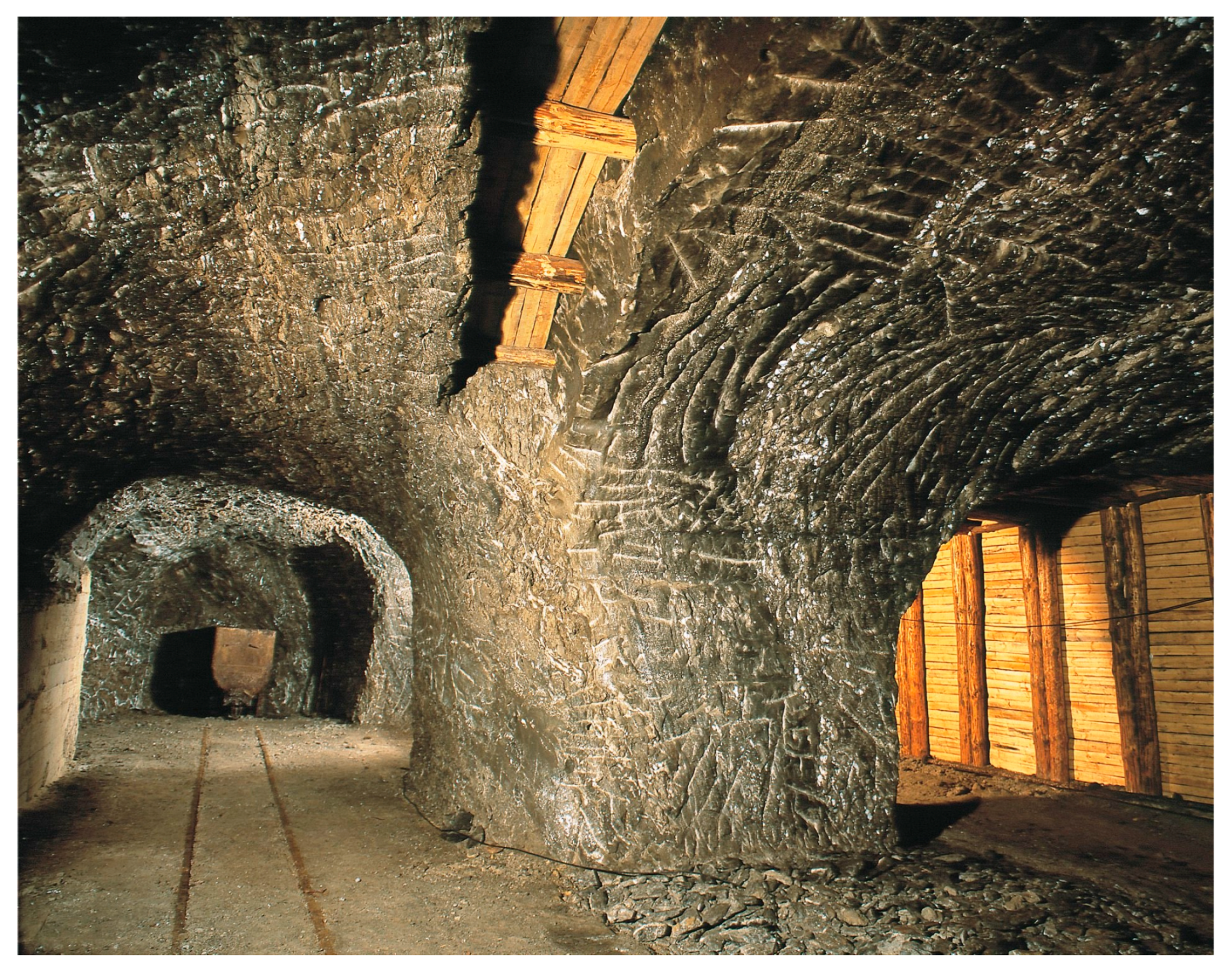
2. Classification of Underground Excavations

The integration of their original function with new uses for underground spaces should be carried out within a contextual framework. The original function is preserved through the recognition of the site’s value, not merely as an individual structure but also as a part of the broader regional context (Figure 1). In the context of sustainable development, a major aspect to be considered when securing and adapting old excavation sites is the integration of the existing buildings and structures with broadly understood natural ecosystems.
The authenticity of preserving local memory and regional identity plays a decisive role in this process. Underground heritage becomes a medium for showcasing cultural distinctiveness and can evolve into a specialised tourism product. It may serve as a hybrid between historical significance and contemporary tourist expectations. These sites act as unique bridges between different values—historical and modern, tangible and intangible, social and economic (Table 1). Creative adaptations, with their commercial nature and potential for financial self-sufficiency, present a viable means of fulfilling the principle established by Prof. J. Zachwatowicz: “Every heritage site must find a life-sustaining function most suited to it, ensuring its continued existence and preservation” [8].
Mining excavations are void spaces created within a mineral deposit or barren rock as a result of mining operations. Underground excavations take shapes similar to geometric solids, such as cubes, cuboids, prisms, cylinders, or their combinations. Their cross-sections are most commonly rectangular, square, trapezoidal, circular, elliptical, or composed of segments and combinations of these forms (Table 2).
A very popular classification is also based on the function of a given excavation (Table 3).

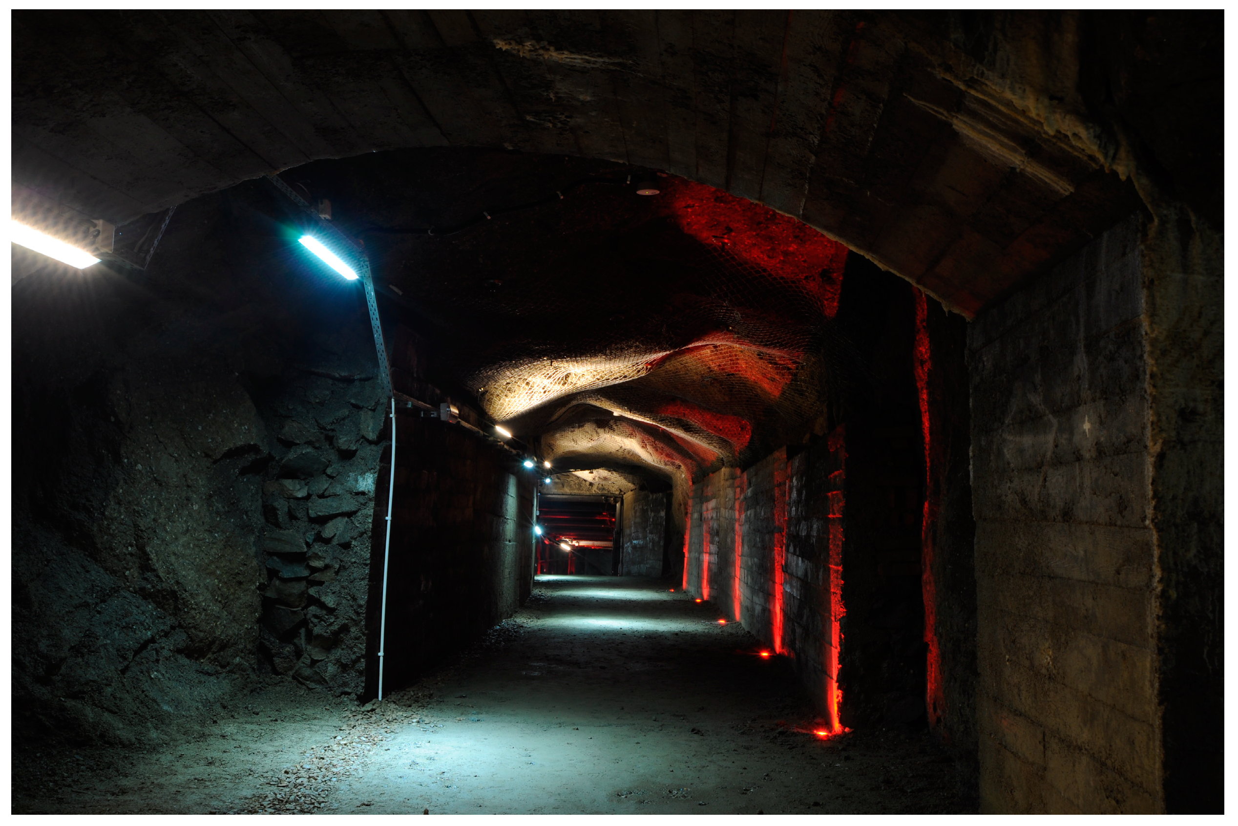
3. Recognition and Identification of Spatial Structures in Underground Excavations

The technical inventory is carried out through in situ penetration methods—underground surveys and observations (Figure 2). The scope of such an analysis results, first of all, from the interdisciplinary coordination between the investment plan, outlined in the spatial/programmatic concept, and detailed studies on the condition of the internal space of the underground structure. Additionally, it is based on the assessment of static and strength properties carried out during the preliminary reconnaissance stage (Figure 3) [10].
By performing a technical inventory, it is possible to proceed with the preparation of the so-called Master Plan for the accessibility of underground workings, along with an analysis of the possibilities for adapting them to a new function and defining issues related to user safety (Figure 4). The Master Plan should be regarded as a comprehensive document encompassing the entire analytical and research process of existing underground anthropogenic and natural structures, the development of a functional and operational program, as well as economic analyses.
Unfortunately, some mines cannot be repurposed due to destruction caused by industrial disasters. Therefore, it is crucial to assess the feasibility of reusing underground mines based on the type of activity [11]. Given the large number of these sites, not all can be designated as cultural heritage, making it necessary to develop appropriate legal regulations for determining their future use. The analyses presented in this article aim to evaluate the adaptive potential of excavations, including the possibility of their approval for further use.
The scope of analyses and studies primarily concerns research related to the assessment of the safety of underground spaces, with the implementation of contemporary systems and technologies for preserving historical cultural heritage. This assessment is carried out based on the analysis of archival documentation, the results of mining/geological reconnaissance studies, a technical inventory, and the technical review of the existing infrastructure of the underground facility.

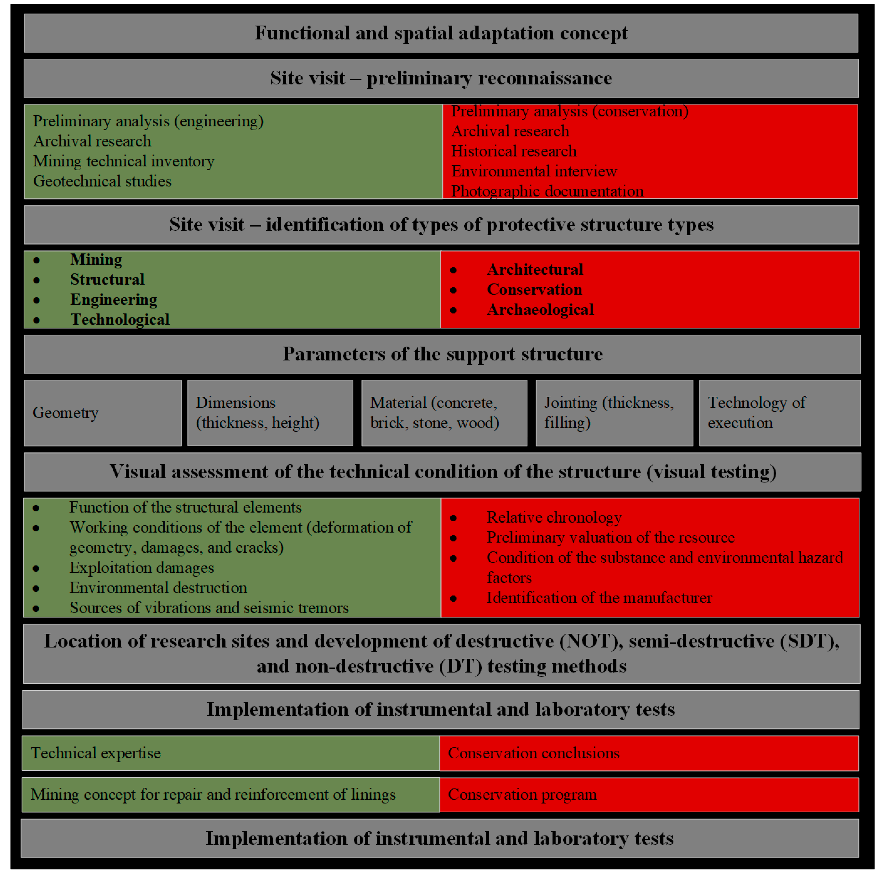
4. Functional–Spatial Diagnostics of Underground Spaces

The preliminary assessment of the feasibility of implementing new functions in commercial underground excavations requires an examination of the synergy between existing structures and applicable legal and technical regulations. Key regulations, such as the Geological and Mining Law [12], the Building Law [13], the Environmental Protection Law [14], as well as laws concerning nature conservation [15] and heritage protection [16], along with the regulation on technical conditions [17], form the foundation for this analysis.
From an architectural perspective, it is essential to understand how new functional uses can be integrated with pre-existing underground systems, including excavations, tunnels, chambers, and adits, as well as with new structures that were not originally part of this ecosystem. Such studies enable the sustainable development of underground spaces, taking both legal and technical aspects into account.
In the context of multi-variant analysis, understanding how an adaptive approach to underground facilities not only protects their unique characteristics but also introduces innovative solutions that harmonize with modern spatial requirements is crucial to ensure they are consistent with the environmental and social aspects of sustainable construction. The optimization of functional accessibility in existing structures requires a well-thought-out elimination of potential threats to cultural and natural values that may arise during the adaptation process. In this light, the priority is to integrate the new function with the surrounding environment, considering the specificity of the microclimate and geodiversity, as well as preserving post-industrial heritage. This approach helps avoid arbitrary decisions that could lead to irreversible changes in the character of underground facilities [18].
Underground excavations, as a complex spatial system, play a key role in spatial organization, linking various elements into a network that has developed over an extended period. As these structures evolve, a functional and spatial assessment becomes essential to understand how they can be transformed in response to changing conditions. The adaptation process, which includes modifications to the geometry of tunnels, corridors, and chambers, not only improves their usability but also contributes to the preservation of underground heritage (Figure 5). The primary objective of these efforts is to minimize the negative effects of both natural and anthropogenic decomposition, ultimately leading to investment cost optimization and the protection of valuable resources.
The fundamental principle of functional and spatial adaptation in mining excavations is to maintain the coexistence of contemporary functional requirements introduced by their new use while preserving their historical, anthropogenic, and natural value. This process should include the following:
-
The continuation or restoration of their historical function;
-
Non-invasive work methods;
-
The preservation of spatial and structural neutrality;
-
The enhancement of cultural and material values;
-
The maintenance of aesthetic integrity, including the protection of historical authenticity;
-
The implementation of reversible modifications;
-
The concealment of undesirable elements rather than their removal;
-
A rescue program for objects threatened by natural degradation [9].
The concept of adaptive capacity refers to the ability to meet specific requirements through the transformation of existing natural and anthropogenic structures. A preliminary assessment program for spatial parameters, the condition of technical infrastructure, and safety conditions in underground excavations designated for adaptation are presented graphically in the diagram below (Figure 6).
The scope of these transformations and their impact on the protection of cultural and natural heritage values, as well as the decomposition of underground excavation spaces, can only be defined and assessed at the stage of technical and conservation diagnostics (Figure 7).
Due to the nature of this type of study, the assessment of adaptive potential and the proposed selection of requirements are focused on priority elements, such as room geometry, user safety, fire safety, and technical infrastructure analysis. From the authors’ experience in developing adaptation projects for underground mining heritage, it follows that these requirements are the key factors determining the proper evaluation of an underground facility as “material” for further programmatic, diagnostic, or even economic analyses. An excessive expansion of requirements at this stage of diagnostics eliminates the flexibility of the design process and, as a result, may even prematurely end the adaptive process, which in practice could lead to the physical loss of the underground facility and, ultimately, the erasure of its existence from public awareness.

5. Selection of a New Function—Functional–Spatial Program

The application of a new function to underground structures, involving interference with cultural and natural heritage, poses a threat to their authenticity, integrity, or uniqueness, which may lead to the loss of significant characteristics demonstrating these values. These objects should be “alive” and socially active, and, consequently, they should adapt functionally to changing socio-cultural conditions in a manner that ensures their survival [4,19]. English Heritage states that a key element in the adaptation process is the proper diagnosis and reinforcement of the historical significance of places and objects. At the same time, it is necessary to introduce changes that are essential for maintaining the usability of the site and ensuring continued enjoyment when interacting with it. The continuity of use, in the case of historic underground spaces, should be approached with the awareness that the original use program may no longer ensure that continuity [20].
Underground heritage objects must be adapted to the requirements of their contemporary use while preserving their geological environment, functional–spatial arrangement, and technical/technological equipment, based on the results of a value analysis, applying an appropriate level of visibility for acceptable changes (Figure 8).
The specificity of underground objects, stemming from the synergy of cultural and natural heritage, particularly the influence of geological conditions on the formation of the spatial structure of underground objects, determines additional and individual requirements for the creation of functional–spatial programs [21]. The implementation of a new function, in the context of historic underground workings, should, similarly to above-ground heritage objects, result from the synthesis of morphological features and technical-spatial assumptions.
The requirements for function arise from the regulations on both construction and mining and geological law. The basis for the analysis of the spatial structure of the underground object in the process of selecting a new function is the establishment of guidelines concerning characteristics/requirements.
The basis for proper pre-project work and analysis, in the context of creating a functional–spatial program and retrospective and prospective values, is the development of guidelines that include the following (Figure 9):
-
Analysis of geological/geotechnical conditions: the state of preservation of the rock mass, a hazard analysis, an assessment of user safety, and an evaluation of the impact of protective works on the preservation of the spatial structure;
-
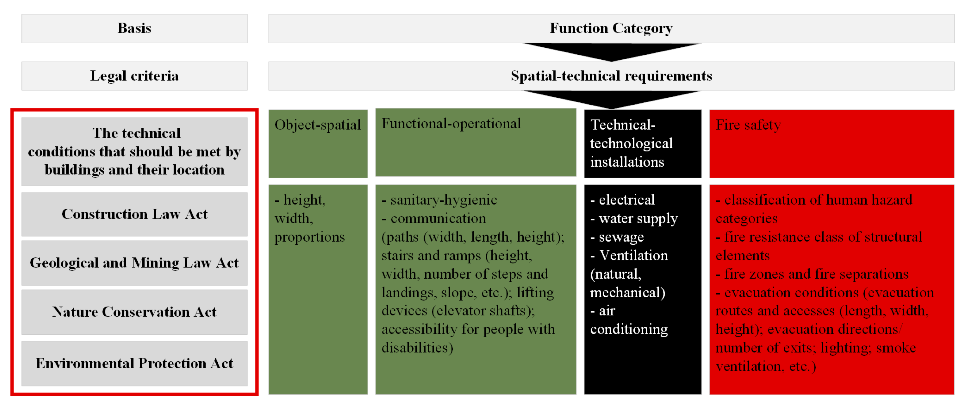
Ensuring safety: adapting the object to the requirements of construction and mining regulations;
-
Geometrical analysis of the workings: determining the adjustment of technical possibilities;
-
Technical infrastructure: assessing the functionality of the existing technical infrastructure;
-
Assessment of adaptive interference: the impact of protective and adaptive works on the preservation of underground heritage (cultural and natural) during the adaptation process, including evacuation and fire safety;
-
Landscape value: protection of local panoramas, views, landmarks, surroundings, etc.;
-
Emphasizing natural values: preserving the authentic spatial structure while considering geo-diversity;
-
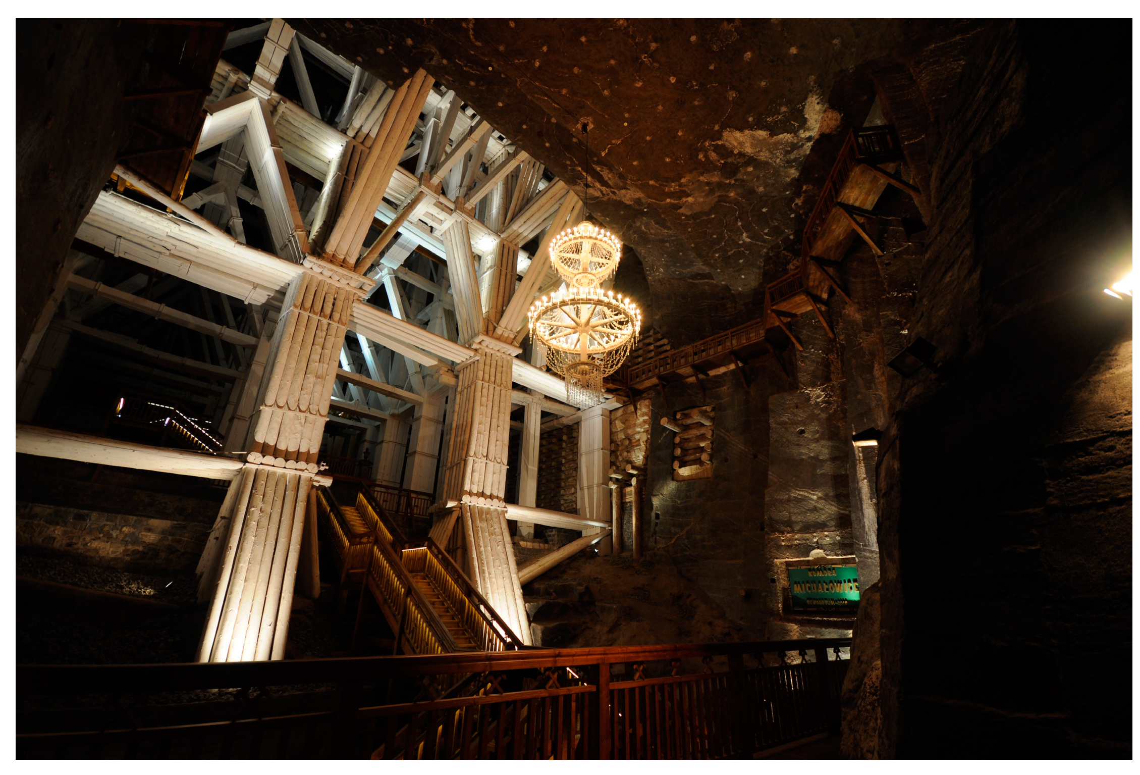
Visibility of cultural values: preserving the technical heritage value (e.g., mining heritage) through maintaining authenticity and integrity, allowing for its recognition (Figure 10);
-
Maintaining cultural diversity: preserving the underground object in the public space and landscape and securing a record of its meanings and traditions according to memories, customs, and practices;
-
Protection and preservation of movable objects: completing an inventory, holding an in situ exhibition, and recycling—reusing elements such as preserved mining supports and technical infrastructure as elements of designed architectural details and the interior architecture;
-
Shaping underground space with light: assessing the potential for implementing solutions enabling its safe use;
-
Social conditions: assessing the real and identified needs of the local community;
-
Political dimension: shared cultural and natural heritage; the identification of identity and generational links;
-
Development of tourism potential: generating new jobs, creating a new brand, developing traditional crafts, promoting qualified underground tourism and new thematic trails, and utilising microclimatic conditions for natural healing [22];
-
Cognitive and educational value: the presentation and contextual popularization of its geo-diversity values, technofacts (historical mining support structures, technical equipment, and methods of rock mass exploitation), and traditions through interpretative communications and presentation methods—3D mapping, reenactments, theatrical and museum-like space presentations (light/sound performances), sensory contact (hands-on) with movable heritage, shaping with light (geospatial illumination), local ceremonies related to the traditions of the site (recreating historical crafts), and the preservation of the cultural heritage of the region (the traditional behaviours of professional groups), etc.
Adaptive design is, therefore, very limited and essentially involves adjusting the user program to the morphological characteristics of the underground object. Excessive interference with the spatial structures can become economically ineffective. The costs of mining works, such as rock mass stabilisation, improving stability, or changing spatial and volumetric relationships to adapt an object to a new function, may constitute an insurmountable economic barrier.
In many cases, these works are staged and carried out step by step. It can be unequivocally stated that the success of a project to make underground objects accessible is conditioned by the staged approach to the objectives arising from the coordination of morphological features and the functional program.
The morphological characteristics of an underground object can be divided into two components:
-
Natural—morphostructure, hydrological conditions, geotechnical conditions, the geodiversity of the underground environment, etc.;
-
Cultural—resulting from human intervention in the underground object’s space (both passive and active)—volume, surface area, proportions, lighting, etc.
However, when assessing the adaptability of the workings to a new function, a slightly different set should be considered, which is summarized in Figure 11.
The proportions, volume, and form of the workings’ space are the result of methods used to extract the rock mass and environmental conditions, while their aesthetic form is the outcome of the influence of these factors on technical and technological solutions. Therefore, the basis of the work is a comparative analysis of the physical characteristics of the existing object with the technical and spatial requirements for the new designated function.

6. Conclusions

This article on assessing the functional and spatial characteristics of historical underground mining excavations in the context of selecting a new utility function contributes to sustainability by promoting the adaptation of historic underground structures, which can be repurposed in an efficient and environmentally friendly manner. The proposed approach not only preserves cultural heritage but also integrates these sites into modern functions, such as cultural or tourist activities, thus ensuring their long-term use and reducing the need for new constructions.
The adaptation of underground objects to new functions presents an interdisciplinary challenge, requiring the consideration of regulations from the perspective of various areas of law. The lack of a clear classification for these objects in current legal regulations leads to difficulties in their management. After the cessation of mining operations, these objects no longer fall under the provisions of the Geological and Mining Law, and at the same time, they are not explicitly covered by the Building Law. This legal gap results in interpretive ambiguities, significantly complicating the design and adaptation processes.
The proposed method for assessing the functional and spatial characteristics of historical underground mining excavations in the context of selecting a new utility function is a comprehensive tool that offers numerous benefits. Primarily, it enables an accurate evaluation of the actual condition of an excavation in relation to the planned change in its use. It serves as a key element in initiating an investment process, providing the opportunity to repurpose an inactive site. Additionally, it allows for the development of a coherent master plan for underground spaces and engages interdisciplinary teams of experts, fostering the creation of optimal solutions. A significant advantage is also the initiation of public participation, which increases the acceptance of new functions for the site and involves the local community in the decision-making process.
However, this method also presents several challenges. Its implementation requires significant effort and financial resources, as well as interdisciplinary expertise and extensive public consultations. It is a long-term process that does not always yield tangible benefits and, in some cases, may be abandoned due to the complexity of decision-making procedures. Furthermore, the lack of appropriate legal regulations and the unavailability of archival mining documentation can create significant risks during the adaptation process. As a result, property owners or users often withdraw from adaptation efforts or discontinue them at the formal procedure stage. Additionally, the undertaken actions require securing financial resources for the entire investment, as the process cannot be carried out in stages.
In conclusion, the proposed method is a valuable tool for assessing and planning new utility functions for historical underground excavations. However, its effectiveness depends on various factors, including available resources, legal frameworks, and the engagement of all stakeholders.
In practice, efforts to repurpose underground objects are mainly based on the provisions of the Building Law, specifically the Regulation on Technical Conditions, which is the only available tool for adapting these spaces to new functions while maintaining safety standards. However, the absence of dedicated regulations for underground objects means that their adaptation requires individual analyses and non-standard design solutions.
An additional complication is the lack of regulations regarding the protection of cultural heritage in the context of inactive mining workings. The Heritage Protection and Conservation Act does not consider them as part of cultural heritage, even though some of these objects possess significant historical and architectural value. An exception is made for four sites listed as UNESCO World Heritage Sites (the salt mines of Wieliczka and Bochnia, Tarnowskie Góry, and Krzemionki Opatowskie), demonstrating that only a few workings have received formal recognition and protection [22].
It is also worth noting that, after mining operations cease, regions situated above underground excavations often remain, necessitating closure processes that comply with applicable technical regulations. Typically, mine owners do not anticipate covering the costs of closure [4,23]. Establishing a standardized approach to the decommissioning and repurposing of underground mines is crucial, as it facilitates securing funding not only for their closure in accordance with technical requirements but also for maintaining the structural integrity of these sites. This, in turn, ensures the safety of residents in affected regions.
By employing sustainable design practices and considering technical, social, and economic aspects, this article demonstrates how existing resources can be utilised in a way that minimizes negative environmental impacts and contributes to the development of local communities. The adaptation of such sites reduces the consumption of raw materials, energy, and space, aligning with the goals of sustainable development while promoting social responsibility and the protection of cultural values. In essence, our research demonstrates how heritage conservation and sustainability can go hand in hand, offering a solution that benefits both the environment and society.

Author Contributions

Conceptualisation, A.R. and T.W.; methodology, A.R. and T.W.; software, A.R. and T.W.; validation, A.R. and T.W.; formal analysis, A.R. and T.W.; investigation, A.R. and T.W.; resources, A.R. and T.W.; data curation, A.R. and T.W.; writing—original draft preparation, A.R. and T.W.; writing—review and editing, A.R. and T.W.; visualisation, A.R. and T.W.; supervision, A.R. and T.W.; project administration, A.R. and T.W.; funding acquisition, A.R. and T.W. All authors have read and agreed to the published version of the manuscript.

Funding

This research received no external funding.

Institutional Review Board Statement

Not applicable.

Informed Consent Statement

Not applicable.

Data Availability Statement

The original contributions presented in this study are included in the article. Further inquiries can be directed to the corresponding author(s).

Conflicts of Interest

The authors declare no conflicts of interest.

References

  1. Chmura, J.; Wieja, T. Górnicze metody zabezpieczania i rewitalizacji podziemnych obiektów zabytkowych. Ochr. Zabyt. 2010, 1-4, 245–254. [Google Scholar]
  2. Schubert, M.; Paffenholz, J.-A.; Langefeld, O. Investigation of Historic Mining Infrastructure in the Upper Harz Mountains and Development of Repurposing Concepts; Mining Report Glückauf; Bergbau-Verwaltungsgesellschaft mbH: Senftenberg, Germany, 2024; Volume 160, p. 372381. [Google Scholar]
  3. Liessmann, W. Historischer Bergbau im Harz; Springer: Berlin/Heidelberg, Germany, 2010. [Google Scholar] [CrossRef]
  4. Sutrisno, A.D.; Chen, Y.J.; Suryawan, I.W.K.; Lee, C.H. Building a Community’s Adaptive Capacity for Post-Mining Plans Based on Important Performance Analysis: Case Study from Indonesia. Land 2023, 12, 1285. [Google Scholar] [CrossRef]
  5. Konieczna-Fuławka, M.; Szumny, M.; Fuławka, K.; Jaśkiewicz-Proć, I.; Pactwa, K.; Kozłowska-Woszczycka, A.; Joutsenvaara, J.; Aro, P. Challenges Related to the Transformation of Post-Mining Underground Workings into Underground Laboratories. Sustainability 2023, 15, 10274. [Google Scholar] [CrossRef]
  6. Finucane, S.J.; King, J.C.; Tarnowy, K.M. The 5R Model: Facilitating decision-making on repurposing of industrial and ancillary infrastructure. In Mine Closure 2022: Proceedings of the 15th International Conference on Mine Closure; Australian Centre for Geomechanics: Perth, Australia, 2022; Volume 1, pp. 295–306. [Google Scholar]
  7. Finucane, S.J.; Tarnowy, K. New uses for old infrastructure: 101 things to do with the ‘stuff’ next to the hole in the ground. In Mine Closure 2019: Proceedings of the 13th International Conference on Mine Closure; Australian Centre for Geomechanics: Perth, Australia, 2019; Volume 2019, pp. 479–495. [Google Scholar]
  8. Zachwatowicz, J. Program i Zasady Konserwacji Zabytków; PIHS: Islamabad, Pakistan; ZAP: London, UK; HS PW: Warszawa, Poland, 1946. [Google Scholar]
  9. Wieja, T. Ochrona i Adaptacja Zabytkowych Podziemnych Wyrobisk; Wydawnictwo AGH: Kraków, Poland, 2019; Available online: https://wydagh.agh.edu.pl/produkt/824-ochrona-i-adaptacja-zabytkowych-podziemnych-wyrobisk (accessed on 3 March 2025).
  10. Radziejowska, A.; Wieja, T. Cause-and-effect Analysis of Anthropogenic and Natural Aspects in the Process of Assessing the Material Heritage Resource in Underground Mining Adaptation Planning. Civ. Environ. Eng. Rep. 2024, 34, 449–461. [Google Scholar] [CrossRef]
  11. Ostręga, A.; Szewczyk-Świątek, A.; Cała, M.; Dybeł, P. Obsolete Mining Buildings and the Circular Economy on the Example of a Coal Mine from Poland—Adaptation or Demolition and Building a new? Sustainability 2024, 16, 7493. [Google Scholar] [CrossRef]
  12. Geological and Mining Law Act. Ustawa Prawo geologiczne i górnicze, Poland. 2011; pp. 1–266. Available online: https://isap.sejm.gov.pl/isap.nsf/DocDetails.xsp?id=wdu20111630981 (accessed on 2 January 2025).
  13. Construction Law Act. 7.07.1994 r., stawa z dnia 7 lipca 1994 r. Prawo budowlane. 2021; pp. 1–140. Available online: https://isap.sejm.gov.pl/isap.nsf/DocDetails.xsp?id=wdu19940890414 (accessed on 2 January 2025).
  14. Nature Conservation Act. Ustawa z Dnia 27 Kwietnia 2001 r. Prawo Ochrony Środowiska. Available online: https://isap.sejm.gov.pl/isap.nsf/DocDetails.xsp?id=wdu20010620627 (accessed on 12 February 2025).
  15. Environmental Protection Act. Ustawa z Dnia 16 Kwietnia 2004 r. o Ochronie Przyrody. Available online: https://isap.sejm.gov.pl/isap.nsf/DocDetails.xsp?id=wdu20040920880 (accessed on 12 February 2025).
  16. Protection of Monuments and the Care of Monuments Act. Ustawa z Dnia 23 Lipca 2003 r. o Ochronie Zabytków i Opiece Nad Zabytkami. Available online: https://isap.sejm.gov.pl/isap.nsf/DocDetails.xsp?id=wdu20031621568 (accessed on 12 February 2025).
  17. The Technical Conditions That Should Be Met by Buildings and Their Location Regulation. Rozporządzenie Ministra Infrastruktury w Sprawie Warunków Technicznych, Jakim Powinny Odpowiadać Budynki i Ich Usytuowanie. 2019; pp. 1–112. Available online: https://isap.sejm.gov.pl/isap.nsf/DocDetails.xsp?id=WDU20220001225 (accessed on 2 January 2025).
  18. Regulation of the Minister of the Environment on the Mining Plant Operation Plans. Rozporządzenie Ministra Środowiska w Sprawie Planów Ruchu Zakładów Górniczych. 2017. Available online: https://isap.sejm.gov.pl/isap.nsf/DocDetails.xsp?id=WDU20170002293 (accessed on 2 January 2025).
  19. Serda, M.; Szmygin, B.; Molski, P. Zamki w Ruinie—Zasady Postępowania Konserwatorskiego; Uniwersytet Śląski: Katowice, Poland, 2012; Volume 7, pp. 343–354. [Google Scholar]
  20. Constructive Conservation|Historic England. Available online: https://historicengland.org.uk/images-books/publications/constructive-conservation-sustainable-growth-historic-places/ (accessed on 12 February 2025).
  21. Regulation on the Detailed Scope and Form of Project Documentation, Technical Specifications for the Execution and Acceptance of Construction Works, and the Functional and Utility Program. 2.09.2004. Rozporządzenie Ministra Infrastruktury z Dnia 2 Września 2004 r. w Sprawie Szczegółowego Zakresu i Formy Dokumentacji Projektowej, Specyfikacji Technicznych Wykonania i Odbioru Robót Budowlanych Oraz Programu Funkcjonalno-Użytkowego. Available online: https://isap.sejm.gov.pl/isap.nsf/DocDetails.xsp?id=WDU20042022072 (accessed on 12 February 2025).
  22. UNESCO. Operational Guidelines for the Implementation of the World Heritage Convention; UNESCO: Paris, France, 2012. [Google Scholar]
  23. Didier, C. Postmining Management in France: Situation and Perspectives. Risk Anal. 2009, 29, 1347–1354. [Google Scholar] [CrossRef] [PubMed]
Figure 1. Former German excavation site adapted into the “Projekt Arado” underground tourist route in Kamienna Góra, identifying the site’s value.
Sustainability 17 03301 g001
Figure 2. Technical inventory—identification of spatial, geotechnical, and historical technical infrastructure parameters (source: own study).
Sustainability 17 03301 g002
Figure 3. A—Technical inventory—longitudinal section of the Franciszek Karol chamber, B—geological cross-section in the immediate vicinity of the Franciszek Karol chamber (source: technical documentation of Wieliczka Salt Mine S.A. by Przybyło J. from 2006).
Sustainability 17 03301 g003
Figure 4. Scope of parallel diagnostics in the process of assessing the condition of existing mining workings in the context of heritage protection and the implementation of a new functional purpose (source: own study).
Sustainability 17 03301 g004
Figure 5. MW chamber—original state before adaptation into a sanatorium chamber (Bochnia salt mine).
Sustainability 17 03301 g005
Figure 6. Methodology for defining the functional and spatial characteristics of an underground facility.
Sustainability 17 03301 g006
Figure 7. Methodology for selecting categories of spatial and technical requirements in the function selection process (source: own study).
Sustainability 17 03301 g007
Figure 8. Modern intervention while preserving traditional excavation reinforcement technologies in the J. Słowacki chamber (Wieliczka salt mine).
Sustainability 17 03301 g008
Figure 9. Definition of issues related to the assessment of the possibility of adapting given underground workings to new functions.
Sustainability 17 03301 g009
Figure 10. Clarification of cultural values—reconstruction and repair of the truss support in the Michałowice chamber (Wieliczka salt mine).
Sustainability 17 03301 g010
Figure 11. Morphological features representative for the adaptive assessment of underground workings (source: own study).
Sustainability 17 03301 g011
Table 1. Change of use—combination of original function with new assigned function for underground works in Poland (source: own study, [9]).
LocationType of ComplexName of ObjectFunctionDate
* BochniaPost-industrial/mining/salt mineHealth Resort—
Bochnia Salt Mine
UTR, Health (sanatorium), sports hallXVIII
century
ChełmMining—chalk mineChełm chalk undergroundsUTR1972
Jelenia Struga near KowaryMining/tunnels/uranium mineKowary tunnels—Jelenia Struga CenterUTR, UET,
health (sanatorium)
2000
KletnoPost-industrial/mining/uranium mineKletno uranium mineUTR2002
KłodawaPost-industrial/mining/salt mineKłodawa salt mineUTR, MM, culture (concert hall)2004
* KrzemionkiMining/works/flint mineNeolithic flint mine in Krzemionki OpatowskieUTR1985
KowaryMining/tunnels/uranium minePodgórze uranium mineUTR2011
Krobica/MirskMining/tunnel/tin mine“Geopark—traces of former ore mining” in KrobicaUTR, UER (geopark)2013
Nowa RudaPost-industrial/mining/coal mineUnderground tourist coal mine—mining museum in Nowa RudaUTR, MM1996
Rybnik-Niewiadom Post-industrial/mining/coal mineHistoric “Ignacy—Horym” MineUTR, MM
* Tarnowskie GóryPost-industrial/mining/silver mineSilver ore mine, museum in Tarnowskie Góry, “Black Trout” tunnelUTR, MM1976/1957
Tomaszów MazowieckiWorks/glass sand mineNagórzyckie cavesUTR2012
* WieliczkaPost-industrial/mining/salt mineWieliczka salt mineUTR, MM, Health (sanatorium)XVII century
WiryMining/magnesite mineMagnesite mine in WiryUTR2 June 2017
ZabrzePost-industrial/mining/coal mineGuido mine in Zabrze, “Queen Luiza” mining open-air museum in ZabrzeUTR, MM1982/1985
SzklaryPost-industrial/mining/nickel mineUnderground educational route in the “Robert” tunnel, “Szklary-Huta” mineUER2013
Złoty StokPost-industrial/mining/arsenic mineGold mine in Złoty Stok (underground mining and gold metallurgy museum)UTR, MM1985
UTR—underground tourist route. UER—underground educational route. MM—mining museum. *—listed as a UNESCO World Heritage Site.
Table 2. Classification of underground works based on geometry of shape and dimensions (source: own study based on [9]).
Geometry
Corridor excavationsSmall cross-sectional to length ratio (shafts, drifts, crosscuts, and galleries).
Chamber excavationsLarge excavations with a cross-section greater than 20 m2 (sublevels, various machine chambers, electrical rooms, underground workshops, etc.).
Extraction excavationsVarious shapes depending on the thickness and inclination of the deposit (seams and veins) and the extraction method used (room-and-pillar, stope, wall, and chamber).
Table 3. Classification of underground works based on purpose (source: own study based on [9]).
FunctionCharacteristic
Exploratory/
recognition
Research on boreholes
AccessEnables mining exploitation in underground mines; these are excavations connecting the deposit with the surface
Type
Vertical (45°–90°)Shaft—A corridor excavation with a slope greater than 45° and a depth greater than 200 m, with a cross-section greater than 15 m2, connecting the deposit with the surface
Winze—A vertical corridor excavation, with a depth of less than 200 m and a cross-section smaller than 14 m2, having an entry at the surface and leading down into the earth
Dukla—A shallow (up to 30 m) winze with a small cross-section, made in hard rocks without lining
Inclined (4°–45°)Decline—A corridor excavation with a drilling direction from top to bottom
Rise—A corridor excavation with a drilling direction from bottom to top
Horizontal (<4°)Adit—A horizontal corridor excavation leading from the slope of the mountain into the deposits of ore, with one connection to the surface. Adit tunnels are used for gravitational drainage of excavations and transporting ore to the surface, as well as for providing access to the deposit
Crosscut—A corridor excavation in barren rocks from the shaft, crossing (perpendicular) to the line of the deposit
Leveling—A corridor excavation driven in barren rocks from a crosscut, parallel to the extension of the seams
Sublevel—A set of excavations located in direct proximity to the shaft on a given level
PreparatoryPreparing the deposit for the most efficient extraction method
Type
HorizontalGallery—A corridor excavation conducted horizontally or nearly horizontally (up to a 5° slope)
InclinedRise—A corridor excavation connecting two or more points located at different levels. Depending on the direction of the ore transport, it is called either a decline or incline
Extraction (operational)Designed for extracting useful ore
Disclaimer/Publisher’s Note: The statements, opinions and data contained in all publications are solely those of the individual author(s) and contributor(s) and not of MDPI and/or the editor(s). MDPI and/or the editor(s) disclaim responsibility for any injury to people or property resulting from any ideas, methods, instructions or products referred to in the content.

