Abstract
Cities are facing the combined effects of multiple challenges, e.g., climate change, biodiversity, pollution, and lacking resources. Synergic innovative solutions are required to simultaneously address them while also considering their social impacts. In this context, the TALEA—Green Cells Leading the Green Transition project, funded by the European Urban Initiative, called Greening Cities (EUI02-064)—aims to tackle urban climate challenges in Bologna (Italy) by mitigating Urban Heat Islands (UHI) and Urban Heat Waves (UHW) through an innovative, nature-based, and data-driven approach. TALEA introduces the TALEA Green Cells (TGCs) concept, modular spatial units that integrate nature-based solutions, creative technological innovation, real-time environmental monitoring, and citizen-science-driven data collection within a broader green infrastructure strategy (Bologna Verde project). TGCs bridge the physical and digital dimensions of urban planning: at the macroscale, they contribute to restoring a continuous urban green corridor; at the microscale, they regenerate underused urban spaces, transforming them into climate shelters and hubs for community engagement. A key feature of TALEA is its digital innovation ecosystem, which integrates data from different sources, including remote sensing, sensors, and citizen-generated inputs, within the Systemic Urban Observation Atlas, the Smart Innovation Package and the Digital Twin that the city of Bologna is developing. These tools enable data-driven decision-making, supporting both urban planners and local communities in designing resilient, adaptive, and inclusive urban environments. The scalability and transferability potential of this integrated approach is tested through its real implementation in three Bologna urban pilots.
1. Introduction
Urban areas, where more than 60% of the world’s population is concentrated, are proposed to be the first agents to face the intertwined crisis that is linked to climate change, limited available resources, loss of biodiversity, pollution, overpopulation, and social inequalities, by which they are primarily impacted [1].
The European Union is one of the most urbanized territories in the world. Its cities are home to over two-thirds of the EU’s population and are responsible for about 80% of its energy consumption [2]. On the other hand, cities generate up to 85% of Europe’s GDP, serve as engines for global and local economies, act as boosters of innovation, and act as enablers of social experimentation. Thus, the European Union is aware that these urban areas must be at the forefront of addressing both the risks and opportunities related to sustainable development, a clean transition, climate adaptation, and resilience, also considering their impacts on liveability and social dynamics [3,4]. The pathways leading to the achievement of such complex and interconnected objectives cannot be traced or followed without innovative, ambitious, but at the same time, concrete policies and actions proactively involving urban decision-makers, stakeholders, and citizens in the development of approaches and methodologies and the implementation of experimentation.
According to the European Environment Agency (EEA) in 2020 (‘SOER 2020’) [5], tackling urgent sustainability challenges requires systemic solutions that, in turn, entail a fundamental, transformative, and far-reaching change that involves significant shifts and realignment in system objectives, incentives, technologies, social practices, norms, knowledge frameworks, and governance strategies.
In order to support and speed up the transition towards climate neutrality, a resource-efficient economy, and the protection of the environment, on 6 April 2022, the EU set out the General Union Action Programme to 2030 (the ‘8th Environment Action programme’ or ‘8th EAP’) as EU’s legally agreed common agenda for environmental policy [6]. The 8th EAP, as the overall Union Environment Action Programme, running until 2030, goes beyond the European Green Deal, which was adopted in December 2019 and represents a framework for the twin green and digital transition. In fact, the priority objectives of the 8th EAP set out a direction for European Union policymaking, building on, but not limited to, the commitments of the strategies and initiatives of the European Green Deal, such as the EU Biodiversity Strategy for 2030 [7], the new Circular Economy Action Plan [8], the Chemicals Strategy for Sustainability [9], and the Zero Pollution Action Plan [10].
The 8th EAP aims to accelerate the green transition to a climate-neutral, sustainable, non-toxic, resource-efficient, renewable-energy-based, resilient, and competitive circular economy while protecting and improving the environment. Moreover, in addition to forming the basis for achieving environmental and climate objectives under the UN 2030 Agenda and its SDGs, it has set long-term objectives to be achieved by 2050, e.g., people should live well within planetary boundaries in a wellbeing economy with regenerative growth, climate neutrality, reduced inequalities, and a healthy environment. These priority objectives need policies and actions, which must be undertaken at different and integrated levels of governance involving the European, national, regional, and local dimensions. The city level is crucial for its centrality in planning and carrying out context-related and calibrated urban transformations, in enhancing non-institutional actors’ engagement and citizens’ participation in urban and environmental decision-making [11], and in exploiting available financial resources, making the best of European funds and direct investments from local sources.
Although cities are making significant efforts in Europe, the integration of climate mitigation/adaptation and clean and green transition measures at the local level still requires improvement [12]. Local actions remain insufficient, with numerous gaps and challenges hindering the urban environment’s ability to build its adaptive and resilience capacity [13].
The multiple scales and complexities of the issues addressed by cities’ governance demand more than conventional policies and services. Urban authorities need to be daring and push to develop their creative and innovative potential in developing and experimenting with new services and solutions to address the growing and interconnected local challenges associated with climate change and sustainable urban development.
In response to this need, the European Commission is sustaining a set of initiatives to support urban areas to develop innovative actions, be able to boost capacity and knowledge building, to interplay policy and practice, and to implement effective, integrated, and replicable solutions in real-life contexts. Among these, the European Urban Initiative—Innovative Actions (EUI-IA, https://www.urban-initiative.eu/about-innovative-actions, accessed on 10 January 2025) is particularly significant in helping city municipalities to overcome limits and constraints that they are experimenting with when testing innovative solutions and groundbreaking initiatives in “real-life” and multi-scale urban contexts.
In fact, the primary goal of this instrument is to promote the implementation of proof-tested urban innovations throughout the EU and to provide cities, as drivers of innovation, with opportunities to take on the risk of transforming ideas into pilot projects that can be tested in actual urban environments. Additionally, this initiative offers an organized and systematic mechanism for knowledge transfer, ensuring that the insights gained from successful innovative actions are efficiently shared and applied across diverse urban contexts in Europe.
This paper deals with the description of the objectives, the methodology, and the principal tools of the innovative solution developed by a research–action project funded by the second EUI-IA, selected through the call for the proposals ’Greening Cities’, opened in the end of May 2023. The project is “TALEA—Green cells leading the Green transition” (EUI02-064), which started in December 2024 and will end in May 2028, with a total duration of 48 months (https://www.urban-initiative.eu/ia-cities/bologna/home, accessed on 15 January 2025). The TALEA project coordinator is the municipality of the city of Bologna (Italy) and the Bologna University is the scientific partner (leading structure: DA—Department of Architecture; junior structures: DISTAL—Department of Agricultural and Food Sciences; DISI—Department of Computer Science and Engineering; DIFA—Department of Physics and Astronomy). The project is the result of the work of the whole consortium of partners; the authors of this paper are members of the TRACE research team of the DA of the Bologna University (for the list of the partners, see the Acknowledgments, and for the DA researchers of the TRACE team, see the website https://da.unibo.it/it/ricerca/progetti-di-ricerca/progetti-in-ambito-internazionale/talea, accessed on 15 January 2025).
Under the topic ‘Greening Cities’, projects are expected to experiment with and deliver tangible innovative solutions on Green Infrastructures (GI) to help cities in addressing climate challenges alongside biodiversity loss, pollution, and depletion of natural resources. In the development of an innovative solution, urban authorities are required to adopt a systemic approach that is able to include synergy development with other key policy areas, such as sustainable mobility, zero pollution of air, water, and soil, building renovation, clean energy, water management, circular economy, and public health, while also accounting for social impacts. In this light, the TALEA project, and in particular, its methodology and specific solution, conceived according with the above-mentioned principles and goals, stands out as a relevant contribution in the ongoing debate about the role and potentialities of urban green spaces in facing climate change issues. The project adopts a systemic, integrated, multi-scale, and multidisciplinary approach, able to combine means and methods to fulfil not only the primary goal of improving climate adaptation and urban biodiversity but also to contribute to other crucial issues, i.e., digital transition, social inclusion, and green justice [14,15]. TALEA conceptualizes, designs, and tests spatial units that serve as connective tissue in both the physical and digital realms and in both the large scale, pertaining to the GI system, and the small scale, pertaining to three pilots located in the dense urban built fabric of the city of Bologna.
This paper is structured as follows: Section 2 outlines the TALEA project framework, introducing the topic of GI in urban environments, the relationship between climate and social vulnerabilities, the TALEA case study, and its main challenges; Section 3, the Materials and Methods, deals with the description of the concept, innovative solution, and methodology of the project; Section 4 describes the main results and outputs of the projects, organized into the three categories Physical Innovation, Digital Innovation and Social Innovation; finally, Section 5 is dedicated to the conclusions.
2. The TALEA Project Framework
2.1. Connective Green Infrastructures in Urban Contexts
In the EU, as in the rest of the world, biodiversity is in continuous decline [16]. According to the regional assessment report on biodiversity and ecosystem services for Europe and Central Asia, drawn by the Intergovernmental Science Policy Platform on Biodiversity and Ecosystem Services (IPBES) [17], the extent of natural ecosystems, such as wetlands, forests, fields, and natural and semi-natural grasslands, has decreased by 50 per cent since 1970, while their habitats have been degraded. The state of green systems is even more critical in urban areas, where land consumption and saturation of the few remaining unbuilt spaces are processes that are struggling to be halted, despite the fact that many cities’ legislations are geared toward “zero land consumption” regulations [18].
With the Council of the EU approving the EU Biodiversity Strategy 2020 [19], both the EU and its Member States have committed to preserving and enhancing ecosystem services and restoring degraded ecosystems by integrating the concept of Green Infrastructures (GI) into spatial planning. GIs are defined as “A strategically planned network of natural and semi-natural areas with other environmental features, designed and managed to deliver a wide range of ecosystem services, while also enhancing biodiversity” [20].
The EU Green Infrastructure Strategy aims to preserve, restore, and enhance GIs to help stop the loss of biodiversity and enable ecosystems to deliver their services to people. The EU Biodiversity Strategy for 2030 promotes investments in green and blue infrastructure, as well as the systematic integration of healthy ecosystems, GIs, and nature-based solutions (NBSs) into urban planning [21,22,23].
In 2019, the European Commission released two guidance documents aimed at assisting planners, policymakers, and businesses in addressing socio-economic challenges while simultaneously safeguarding and rehabilitating Europe’s natural environment. The first, titled “EU Guidance document on a strategic framework for further advancing the development of EU-level green and blue infrastructure”, promotes a more strategic and coordinated approach to increasing investments in EU-level GI projects [24]. The goal is to enhance the connectivity of Natura 2000 areas while also boosting the variety and flow of ecosystem services. The document also outlines available funding sources. In addition, the second document, “Strategic Green Infrastructure and Ecosystem Restoration. Geospatial methods, data and tools” provides tools and methodologies to support the development of strategic GI and ecosystem restoration efforts [25].
Some GI implementations have already been tested at different scales. However, there is no coherence, nor are there any commonly agreed definitions, approaches, and methodologies throughout Europe [26]. Moreover, GIs in urban environments are particularly challenging to be achieved and integrated in the dense tissue of cities. In fact, in penetrating into the urban environment, green and blue infrastructures hybridize with other systems, primarily the built environment and mobility, often undergoing phenomena of caesura and fragmentation, resulting in discontinuities that undermine their logic and systemic functioning. The discontinuities of green/ecological corridors are of various types: spatial, fruitive, ecological. The impacts of such discontinuities are calculated in terms of biodiversity, pollution, CO2, heat islands, perceived wellbeing, soil quality, and permeability, etc. In addition, gaps in green and blue system continuity have repercussions on the possible dynamics of adaptation and resilience to climate change [27]. What is more, the discontinuity of green and blue systems produces impacts on their accessibility, often hindered in deprived neighborhoods. To function in a systemic logic, green and blue infrastructures in the urban environment need to be connected in a complementary and integrated form with the other systems that are intertwined and influence each other.
In the above-mentioned context, TALEA was selected by the EU in order to tackle the issue related to GIs in urban contexts, testing in a real environment an innovative and integrated methodology and the related solution, scalable at the local, urban, and GI scale, which offers the opportunity to mend the discontinuity, stitching up disconnections of GIs in the urban environment.
2.2. Climate and Social Fragilities
The European Environment Agency Report “Towards Just Resilience” (2022) warns that climate change affects those already at a disadvantage because of their age, health, and socio-economic status [28]. According to the report, rising temperature, an ageing European population, urbanization, and disease prevalence are increasingly exposing urban populations to heat-related risks, with nearly half of city hospitals and schools being affected by Urban Heat Island (UHI) and Urban Heat Waves (UHW) effects. Vulnerable groups, the study continues, tend to have lower access to green spaces. This phenomenon is particularly widespread in Mediterranean cities of Southern Europe.
The key challenge of climate justice and of the just transition in cities, therefore, intersects with that of green justice and that of how to combat the UHI phenomenon and the growing intensity and duration of UHWs [29,30].
This has to be achieved at two levels:
- At the GI level, by creating green spaces that are accessible to vulnerable groups while ensuring the provision of ecosystem services. In other words, this entails working to bridge the gaps and missing links between fragmented green spaces, further enhancing their beauty and accessibility, to mitigate marginality and social isolation while also combating UHI and UHW effects on the health and wellbeing of vulnerable groups [31,32];
- At the political level, the GI needs to be implemented and confronted with vulnerable users’ needs and desires. This means developing adaptive planning tools for urban green spaces, using AI to produce cost-effective and data-driven decision-making, and enabling technology to leverage the participation of citizens in the just transition [33].
“Demographic, social and economic fragility in the different areas of the city” is a study published by the Bologna Municipality Bureau of Statistics, whose last update was in 2022 [34]. According to this study, the areas characterized by the highest incidence of vulnerable groups (including children and elders) coincide with those where these groups are more exposed to heat-induced risks.
In the recently published paper titled “Investigating Social Vulnerability to Extreme Heat: Heat Islands and Climate Shelters in Urban Contexts: The Case of Bologna” [35] the authors, from Fondazione Bruno Kessler, a partner of the TALEA project consortium, integrate the fragility map of Bologna with a new index of “social vulnerability to extreme heat” to identify the most vulnerable areas of the city (and populations thereof) to extreme heat due to climate change (Figure 1). The new overall fragility index incorporates social vulnerability to extreme heat as well as socio-economic indicators. The investigation on the relation between social vulnerability to extreme heat and the socio-demographic variables in Bologna found out that a decrease in income is significantly correlated with an increase in social vulnerability to extreme heat in urban contexts.
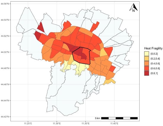
Figure 1.
Visual representation of the social vulnerability to extreme heat indicator (normalized index) on the Bologna Municipality map. The historic city center is identified by the black line. Source: authors’ elaboration based on Maccabiani, E.; Usmani, M.; Nanni, R.; Napolitano, M. “Investigating Social Vulnerability to Extreme Heat: Heat Islands and Climate Shelters in Urban Contexts: The Case of Bologna”. ISPRS Int. J. Geo-Inf. 2025, 14, 17 [35].
Building on this, TALEA will develop a set of qualitative and quantitative indicators that can produce a composite index of local overall vulnerability (General Fragility and Climate Fragility index) and will assess the number of vulnerable people exposed to such risks. Moreover, through the Climate Shelter index (see the definition in the mentioned paper), it will analyze the bioclimatic features of the observed areas, testing them against the backdrop of the desirable bioclimatic conditions of a natural climate shelter [35].
2.3. The TALEA Case Study and Its Main Challenges
Green policies in cities are poorly capitalizing on the wealth of data that is being produced to interpret social and environmental fragilities; research is translated into reporting without accounting for the possibility to use these data dynamically and to produce novel approaches to participation through, for instance, AI and decision-support systems co-designed with citizens [36].
The Italian city of Bologna is in the Pianura Padana, one of the most polluted and droughty areas of Europe, due to heavy industrialization and high population density as well as the particular geography of the region. Bologna, along with the Emilia Romagna region, has been hit hard by rising temperatures: the Regional Climate Observatory of Emilia Romagna has estimated that, compared to the 1961–1990 period, in the 2020–2050 time span, the average annual temperature will shift from 13.9° to 15.6°, with heatwaves lasting for 6 consecutive days (it was 2), 42 tropical summer nights (it was 25), and 31 consecutive days without rain (it was 20). To this dramatic scenario of heatwaves and droughts, another layer of complexity is added, as more than 50% of Bologna’s municipal areas have a poor or very poor hydrological response. In dense urban areas, UHWs are exacerbated by the presence of the UHI effect, which causes intense damage to people’s wellbeing [37]. The local agency Prevention Environment Meteo Forecast Energy of Emilia Romagna (ARPAE) forecasts an extension of UHW length from 2 to 6 subsequent days in 2021–2050.
This situation is shared by many other EU cities, where the fragmentation of ecosystem services, GHG emissions, pollution, and the UHI effect is exacerbated by the scarce presence of green areas, which play a dominant role in contrasting the effects of climate change and of anthropic actions on biodiversity on the quality of ecosystems and on human health [38,39].
In 2019, Bologna declared a climate emergency with predictably higher impacts on vulnerable groups. In response, the city began developing an urban greening strategy aimed at strengthening the ecosystem services and supporting climate resilience.
This commitment has been acknowledged through Bologna’s inclusion in the group of 100 Climate-Neutral and Smart Cities of the mission [40]. With the EU 100 cities mission programme, Bologna has committed to lower GHG emissions by 55% by 2030: a Citizens’ Climate Assembly was created within the mission that contributes to, proposes, and implements local policies.
In this global and local scenario, the TALEA project’s main challenge is to tackle climate change in the city of Bologna, transforming local urban environments in flexible stitching tissues to mend disconnected and fragmented GI organisms, making them effective as ecosystemic connectors. This challenge needs to be faced through a systemic approach, since it can be solved only through the integration of urban green spaces and NBS in wider and continuous GI and through synergy with other policy areas, such as biodiversity, green and energy justice, public health, and energy [41,42].
The municipality of Bologna serves as the coordinator (Main Urban Authority) of the TALEA project, which is in charge of the overall project management and the “Piloting” phase of the TALEA Methodology (see Section 3.2). The project’s objectives are central to the city’s political and institutional priorities and agenda. Key strategic documents, such as the Climate Adaptation Plan [43] and the Sustainable Energy and Climate Action Plan [44], position the green transition and climate change adaptation as primary goals for the administration.
Bologna has already started to plan and design a reconnective system of green corridors, collected in the Impronta Verde project (Green Footprint project), one of the municipality’s flagship initiatives. This strategy envisions a network of six new metropolitan parks that will be interconnected and linked to the city center (see Figure 2). TALEA is part of this broader vision. TALEA will provide a concrete and measurable contribution aimed at connecting urban green areas that are currently disjointed and lack a unified logic and functioning, both ecologically and in terms of use.
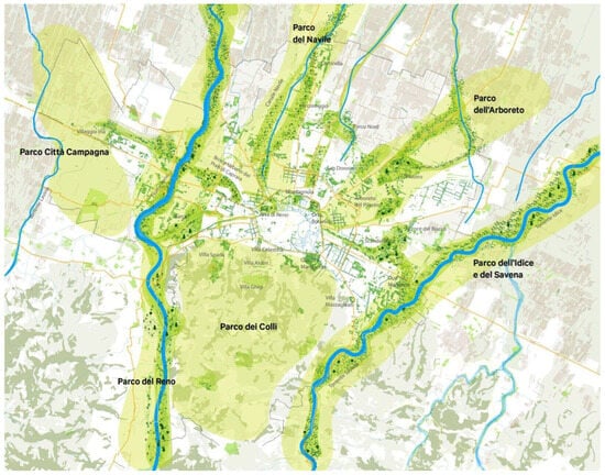
Figure 2.
The Impronta Verde project of the city of Bologna. Blue lines represent watercourses, and green areas represent ecologic corridors. Source: Bologna Municipality.
Additionally, Bologna is developing its Urban Digital Twin, utilizing data to address urban challenges and promote collective knowledge sharing. Part of the City of Knowledge strategy of Bologna, the Bologna Digital Twin (BDT) project will develop a new civic platform, powered by high-performance computing (HPC), Big Data, and AI technologies, to efficiently manage urban challenges. The BDT solution will be exploited by TALEA to speed up digital innovation and maximize impact and sustainability.
Ultimately, the outcomes of the TALEA project will play a key role in shaping the future of urban planning and management in Bologna, informing future public interventions in the urban environment.
3. Materials and Methods
3.1. TALEA Concept and Innovative Solution: Green Cells Leading the Green Transition
As already mentioned in the previous paragraph, the overall TALEA project’s ambition is to contribute to tackling climate change in the city of Bologna by establishing an easily manageable, accessible, measurable, and, above all, continuous Green Infrastructure (GI). In order to achieve this, the specific objective of TALEA is to address the pressing issues posed by the combination of the UHI and UHW effects through the adoption of a solution that can be scaled and applied in public spaces, located in multiple parts of the compact tissue of the city. The solution will be tested in real-life urban pilots and is conceived to be potentially replicated, not only in other parts of the city but also in other EU cities.
TALEA (from the latin word “talĕa” that means “graft”, e.g., “part of a plant capable of emitting roots, used therefore to regenerate a new individual”) develops and tests a solution that combines innovative sets of Nature-Based Solutions (NBS), enhances the exploitation of multi-sourced data and the potential of AI and ICT, and enables multi-level engagement: the TALEA Green Cell (TGC) concept.
A TGC is a compact and highly adaptable spatial unit that serves as connective tissue in both the physical and digital realms. It is a customizable, adaptable, and combinable physical element that represents TALEA’s minimum intervention site. A TGC has a size of 100 × 100 metres; this dimension was determined based on the monitoring possibilities of urban microclimate sensors, represents a significant spatial surround, if taken alone, and it is a module that can be multiplied in case of pursuing larger-scale impacts (see Figure 3). A TGC alone, multiplied or in combination with others, grafts itself in the existing urban tissue and contributes to the mending and enhancement of GI and green corridors and to the beauty, sustainability, accessibility, and liveability of critical urban spaces, according to the New European Bauhaus policy and funding initiative (https://new-european-bauhaus.europa.eu/index_en, accessed on 20 December 2024). Reconnective areas can be configurated by juxtaposing TGCs of the same type, used as basic modules to be adapted in number to the specific needs of the area, or TGCs of different types can be mixed and integrated, depending on their purpose, on the type of green to be reconnected, and on the expected interactions with other systems/infrastructures (mobility, buildings, water system, utility networks, etc.). Their integration into an existing green system, with critical disconnecting elements, allows for the foreshadowing of viable alternative scenarios and ex ante assessment of their impacts on the system as a whole [45,46].
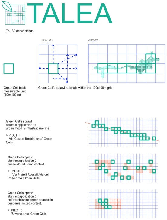
Figure 3.
TALEA Green Cell concept and sprawl rationale. Source: TALEA project.
A TGC is based on proximity and accessibility principles [47,48], and it is capable of generating adaptive actions in the face of climate change, particularly by improving the urban microclimate through interventions in specific areas subject to the UHW and UHI effects. However, the TGC network will not only combat the UHI and UHW effects but will also serve as a catalyst for citizens’ wellbeing, with particular attention to vulnerable people, and will represent the strategic means to foster the green and just transition of the city:
- -
- At the macroscale, TGCs support the reintegration of urban areas into a continuous urban GI;
- -
- At the microscale, TGCs regenerate specific underutilized, inaccessible, and climatically and socially fragile areas.
The TGC solution offers a unique approach, both in its design and methodology, setting it apart from conventional NBSs that focus solely on addressing the UHI and UHW effects in urban areas [49,50]. Its innovation lies in the following:
- Integration: TGCs combine various complementary NBS elements while also considering both social and technical outcomes.
- Openness: TGCs are adaptable, interactive, and collaborative, allowing for the incorporation of real-time data, feedback, and adjustments.
- Measurability: although not a fixed solution, the benefits of TGCs can be assessed using city-specific indicators.
- Integration within the green urban system: TGCs are crafted to fit seamlessly into the broader green urban infrastructure, including ecological corridors and the larger GI system.
- Dynamic evolution: rather than being a static model, TGCs evolve over time, incorporating different systems (social, natural, and technological) to create an expansive, city-wide climate shelter.
To fully exploit the potential of the TGC solution, TALEA proposes an adaptive and data-driven planning methodology (see Section 3.2) for decision-making, co-design, co-creation, and impact assessment of concrete actions, in combination with innovative participation practices. The modular logic of TGCs also allows for interventions to be planned in an incremental manner, adaptive both with respect to the changes and actions that will occur over time and to the evidence produced by the experiments carried out.
3.2. TALEA Methodology
The project methodology is structured into the following three phases (Figure 4): “Inception” (analysis phase), “Piloting” (implementation phase), and “Green city transition” (replicability at the city level and transferability phase).
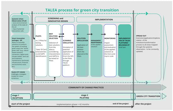
Figure 4.
TALEA process for green city transition.
Monitoring and evaluation are overarching concepts and transversal practices. As such, they have a strong link with all the phases, even if the main monitoring moment is devoted to the impact assessment of the implementation of TGCs in real city contexts.
3.2.1. Data Gathering and Monitoring
The monitoring activities are crucial for the project. The use of TGCs requires a preliminary monitoring of the urban environment, in order to detect the most critical areas subject to the UHI effect, and of green areas, in order to identify the various points of discontinuity. TGCs are introduced where they can be of greatest benefit, not only to the immediate surroundings but also to the effects on the GI system as a whole. This requires simulations of different scenarios in order to be able to select the one with the highest potential positive impact and real feasibility in relation to different variables [38].
Therefore, the simulation of the use of different TGCs and their different combinations represents a decision-making tool for local authorities, supporting evidence-based urban planning.
The first monitoring activities are currently ongoing to establish a baseline assessment of the present situation of the pilot areas in relation to the climatic and social vulnerability level and to set the initial thresholds of the indicators that will be evaluated after the implementation of the TGCs. Such monitoring is taking place through the collection of data from various sources: satellite data, ground-based sensor data, lidar data, and social datasets, including those collected through the active participation of citizens [51,52,53,54,55,56,57].
A local monitoring campaign will soon begin in the pilot areas (the project started in December 2024). This campaign will deploy microclimatic stations that measure the following: temperature, relative humidity, wind speed, air pressure, and mean radiant temperature, which are the variables that enable the Universal Thermal Climate Index (UTCI) to be evaluated [58].
The remote sensing and local monitoring activity will continue during and after the interventions of physical transformation. The monitoring will assess the effects of TGCs, both as individual NBSs and as components of a broader integrated system, allowing for the retrieval of real data for a gradual and better tuning of the characteristics of the TGCs themselves.
TGCs are monitored, designed, and managed by local stakeholders, communities, and the administration, ensuring strong engagement throughout the project. The participation of vulnerable groups is central to the project from the outset. TALEA will collect data through citizen science, leveraging Bologna’s extensive experience in participatory processes. A unique blend of sensing and digital technologies will be deployed, along with both qualitative and quantitative data, to support innovative participatory and co-planning practices (see Table 1). These efforts will be integrated into a Common Digital Environment (TALEA Platform) and will contribute to the development of the Bologna Digital Twin.
In particular, the mapping will be enhanced through the following:
- (a)
- Living labs and participatory mapping of environmental, social, architectural, and economic criticalities and potential for the pilot areas;
- (b)
- The production of an urban atlas, the Systemic Urban Observation Atlas (SUOA).
The Systemic Urban Observation Atlas (SUOA) is a key output of the TALEA project, which was conceived as a knowledge tool to assess the potential and constraints of urban spaces in relation to climate resilience, environmental quality, and historic and social dynamics. Designed as an open-access digital atlas, the SUOA integrates spatial, climatic, historic, urbanistic, and socio-economic data, providing a multi-layered framework for urban analysis. This tool serves as the knowledge foundation of the TALEA platform, supporting evidence-based decision-making and guiding the co-design of interventions aimed at reinforcing green infrastructure, mitigating climate risks, and fostering urban resilience. It is conceived as a digital service and an analytical tool, openly accessible to citizens and usable by the administration, performing analyses at a twofold scale: the micro scale of the pilot area (human sensing and satellite data) and the macro scale (urban sensor data, remote sensing, qualitative data). The intersection of the two scales will help identify UHIs, the possible creation of climate shelters, and safe pathways for both human flows and biodiversity enhancement.
3.2.2. TALEA Inception Phase
This phase aims at producing a shared understanding of TALEA’s vision and methods, a comprehensive mapping of criticalities, and potentials of pilot areas for the green transition. It is also essential to begin contextualizing the TALEA approach in the pilot areas while keeping in mind elements that support its transferability. This phase also includes the research on the state of the art in greening integrated solutions in urban contexts and the knowledge base of the project. For instance, a benchmarking on multi-disciplinary projects on urban greenings and NBS best practices will be carried out, and an abacus of “hardware” solutions for the green transition will be drafted. The regeneration needs, desires, challenges, and opportunities of the three pilot areas will be examined using both qualitative and quantitative approaches, including citizen science initiatives, urban living labs, and data analysis at both the urban and pilot levels (SUOA). At the same time, governance and financial models that support the green transition of cities will be developed, drawing insights from both the benchmarking and the analysis of the three pilot areas. This will ensure a robust, place-based approach, where data-driven evidence is paired with a qualitative understanding of the target users’ needs. This forms the foundation of the entire TALEA process, guiding the co-design of the visions and transformation strategies. The benchmarking and analytical work will also serve as a framework for capacity building within local administrations, promoting an integrated approach to urban green development across various phases and urban system interactions.
3.2.3. TALEA Piloting Phase
The “Piloting” phase of the TALEA Methodology involves the implementation of TGCs to produce beautiful, sustainable green spaces together with the citizens [59].
It is divided into two sub-phases (see Figure 4):
- Screening and Innovative Design:
- Pilots;
- Best solution selection;
- Scenario simulation.
- 2
- Implementation:
- Solution application;
- Management and maintenance of the applied solutions;
- Monitoring;
- Deployment of the TALEA Platform
The majority of the TALEA budget, funded by the EUI (EUR 4,999,984.32) is allocated to this phase, in which the co-designed physical transformations will be carried out in three significant areas of the city. These areas represent the project pilot sites that will host the TGCs as grafts and trigger elements of change. They were selected for their overall fragility and potentiality, assessed overlapping different thematic levels, including climate fragility, socio-demographics, urban ecological networks, and the incorporation of citizens’ proposals through the Bologna Participatory Budgeting process [60,61].
The precise locations of the implementation of the TGCs in the pilots are under definition because they will be the result of the participation activities. The pilot areas are as follows (Figure 5 and Figure 6):
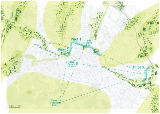
Figure 5.
Connections between the TALEA project strategy and the municipal “Impronta Verde” project on a territorial scale. Pilots 1, 2, and 3 foster the creation of a special and ecological connection in the north sector of the city center of Bologna. The TALEA Future Lab is connected through digital technologies. Source: TALEA project.
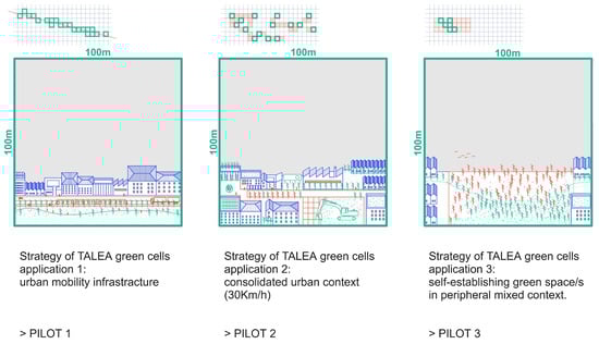
Figure 6.
Strategies of TALEA Green Cells application in the three pilots. Source: TALEA project.
- Pilot 1: Via Cesare Boldrini area, a central space attended by elders, the homeless, and children, where TGCs n.1 and n.2 will be implemented;
- Pilot 2: Via Fratelli Rosselli/Via del Porto area, a historical part of the city frequented by elders, children, students, and the homeless, where TGC n.3 will be implemented;
- Pilot 3: Savena area, an impoverished area just outside the center, which includes different schools and diverse green areas, mainly frequented by elders and children, where TGCs n.4 and n.5 will be implemented.
The three pilots are representative of different urban environments and socio-climatic characteristics: pilots 1 and 2 are in the historic city center, where the UHI phenomenon is accentuated by the density of the buildings and the delicacy of the context results in limitations in the possibilities for action; pilot 3 embeds several types of green areas, i.e., school gardens, public parks, and a free evolution wood, particularly relevant for its biodiversity. Each pilot is also significant because it enables the involvement and modification of not only the green urban system but also other systems, for instance mobility and ecologic corridors, to exploit the TALEA systemic approach.
3.2.4. Green City Transition Phase: Scalability and Transferability
Green Cells are designed to be easily scalable both within the city and beyond. The city is committed to expanding them at multiple levels. The first step involves the Council Participatory Budget process [60], which will allow citizens in other areas to adopt and adapt the solution to their specific needs. The initial phase of scaling up will focus on identifying suitable locations and communities in collaboration with local stakeholders and citizens. In principle, every district could potentially host one or more TGCs. A broader scaling effort is possible through the “Impronta Verde” flagship project, which is included in the city’s investment plan and backed by significant funding. The robust monitoring and evaluation framework of TALEA can also be scaled in tandem with other city digital tools, such as the Bologna Digital Twin, and High-Performance Computing projects (CINECA, the center of excellence in the Italian and European ecosystem for supercomputing technologies, is in the project consortium). To ensure the sustainability of the project’s outcomes, a stakeholder’s board will be established at the project’s outset, bringing together regional authorities of various types. This board will foster connections with other key policy areas (such as health and mobility) and regional urban contexts while promoting alignment with climate-related regional policies and their funding opportunities. Furthermore, it will foster inter-regional and international cooperation.
The “100 Climate-Neutral and Smart Cities” network, which includes cities committed to achieving climate neutrality by 2030, provides valuable opportunities for disseminating the project’s outcomes and solutions. Transfer partner cities were chosen based on common urban challenges, yet they vary in size, social and urban structures, economic features, and geography. These challenges include climate-related issues, urban heat islands, and vulnerability to extreme heat events.
Based on these criteria, Cluj-Napoca (Romania), Marseille (France), and Riga (Latvia) were selected. They are recognized as EU historical cities with significant urban transformation constraints, yet they share a significant need for enhanced urban GI.
The transfer process in TALEA is designed as a proactive, iterative, and mutual learning experience. Transfer cities will observe the application of the TALEA methodology on Bologna’s infrastructure, the development and testing of technologies, and the implementation of TGCs. Additionally, they will receive guidance and support on how to introduce TGCs in their own contexts. Knowledge exchange and peer-to-peer learning are at the heart of the process. Transfer cities will test TALEA tools and methods (see Section 4.3) to assess their usability and offer feedback on the tools’ accessibility and interfaces. The transfer process of the innovative solution will be structured to ensure feedback and recommendations through site visits and benefit from joint evaluation activities. Furthermore, partner cities will work on developing guidelines for implementing the solution in their specific contexts.
4. Results
4.1. TALEA Smart Innovations and the Smart Innovation Package
TALEA’s innovation lies in its ability to combine three key dimensions: Physical Innovation through TGCs and climate shelters, Digital Innovation via the TALEA Platform and data-driven decision-making, and Social Innovation through participatory urban regeneration and citizen-led monitoring (Figure 7). The TGCs are enabled by the activation of the TALEA Smart Innovations, whose combination and specific solutions will be contextualized and place-based depending on the pilot. In particular, the following dimensions will be included:
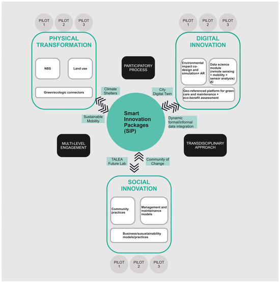
Figure 7.
The Smart Innovation Package and the three TALEA Smart Innovations.
- -
- Physical innovation: climate resilience, urban planning measures, and policy, NBS/urban greening actions, land use, equipment of public spaces, and street furniture.
Output/result: a network of climate shelters, accessibility and sustainable mobility pathways, green corridors integrated in GI, and an abacus of “hardware” solutions for the green transition.
- -
- Digital innovation: climate fragility and environmental monitoring, data-driven co-design, scenario simulation, and impact assessment.Output/result: Systemic Urban Observation Atlas, the TALEA platform
- -
- Social innovation: community practices (e.g., participatory mapping, training and data literacy, co-design and co-construction activities), green management and co-maintenance, and business/sustainability models.Output/result: TALEA Future Lab, Community of Change Methodology
The three components were conceived as interconnected units and converge in an integrated digital tool, the Smart Innovation Package (SIP), which is the key enabler of the TGC solution implementation in the pilots. The SIP is intended as a set of technological and non-technological solutions, business/sustainability models, and policies, all interconnected through a digital environment for the collection, sharing, and analysis of data. This tool will support the placed-based selection of technological, social, and green design solutions in order to activate each TGC; after the identification of the most strategic areas in which to introduce TGCs, the SIP will perform a data-driven elaboration of the best transformative scenarios that will support the formulation of the best combination, characterization, and weight of each Smart Innovation component in each of the three pilots. It will identify the participatory, data-driven, and nature-based method for TGC implementation at both the local level and the GI level, including the generation of benefits for human and non-human ecosystems (e.g., pollinators). The SIP will be designed to be easily transferable and applicable in other parts of Bologna and in other European cities.
Moreover, the SIP activity will assess the robustness of data collected during the monitoring in the TGCs. It will also be necessary to verify the interoperability and usability of the data and tools themselves and the possibility to interpolate the different data sources used within the project. The final evaluation framework will include indicators covering social, environmental, climatic, and economic dimensions, weighted based on their relevance in the SIP for each TGC.
4.2. Physical Innovation: TALEA Climate Shelters
This phase is grounded in an in-depth understanding of the needs, vulnerabilities, and potentials of the pilot areas in terms of urban green areas (or the lack/poor quality thereof) at the local scale and the discontinuities identified in the city’s GI at the macro scale. It has the aim of identifying and designing a set of cross-cutting physical transformations, whose main components are NBSs [62,63,64]
TALEA aims to prototype a solution that can equip the city with a network of diffuse and interconnected climate shelters that can consolidate ecological connections within the city and provide protection during extreme weather events and UHWs. Climate shelters are often conceived as isolated hot spots that make isolation from the surrounding environment the main element of protection, like shopping malls and other air-conditioned premises [65]. TALEA’s goal is to experiment with climate shelters that can lose their introverted nature to become an accessible, inclusive, and open part of the TGC and, through the TGC and its multiplications, part of the GI.
Benefitting from the leading contribution of both the Department of Architecture and the Department of Agricultural and Food Sciences of the Bologna University, the TGC solution is designed by virtue of the interconnectedness and embeddedness of the GI with other urban systems, such as mobility (e.g., pedestrian and cycle paths, the new tramway) and the built environment (e.g., reuse of abandoned buildings), with a specific focus on the unique characteristics of the historic and compact city, included the historic city center. The regenerated spaces within the pilots will evolve not only into climate shelters but also into vibrant hubs, offering socially just services, co-designed with and for the communities.
The main output result of this phase is the Abacus of “hardware” solutions for the green transition, in which existing greening projects, citizen-led greening practices, and best practices of NBS application are collected, analyzed, and benchmarked to represent a toolkit for designing contex-sensitive TGCs and for advancing innovative models of climate shelters.
4.3. Digital Innovation: TALEA Technologies
Easily understandable digital technologies and tools are needed to design and demonstrate the effectiveness of the TALEA Smart Innovations and to find their best composition in the TGC, tailored for the chosen location. Existing successful technologies are not only leveraged and optimized but also redesigned to support the Citizen Science process and to converge in the BDT strategy, in order to expand and maximize their impact and scalability. The SIP supports the customization and integration of existing solutions to develop a unique framework to be tested at different levels. For instance, GREENPASS® (Vienna, Austria), an artificial-intelligence-based platform to quantify and measure the effects of green infrastructures on urban areas and to analyze climate-resilient properties (https://www.r2msolution.com/services/innovative-products/greenpass/, accessed on 10 February 2025), is integrated within a Decision Support System, providing relevant information for decision-making regarding climate, water, air, biodiversity, energy, and costs. The easy-to-use software tool enables the comparison of different transformative projects based on a unique set of Key Performance Indicators (KPIs) that can be used for the planning, design, evaluation, and optimization phases of the TGCs. GREENPASS® makes the effects of green infrastructures visible, measurable, and comparable by delivering information about project performance on climate, water, air, biodiversity, energy, and cost. The evaluation and decision-making system considers up to 28 Key Performance Scores and Indicators. Examples of key performance scores include the following: thermal load, thermal comfort, thermal storage, and carbon sequestration. Examples of KPIs include the following: thermal performance, albedo, shading area factor, evapotranspiration, and wind resistance). Another tool is GreenSpaces, an integrated and geo-referenced platform designed to organize and document the care and maintenance of urban greenery in the most efficient way (https://www.r3gis.com/greenspaces, accessed on 5 February 2025). Green Spaces enables the assessment of environmental benefits, such as CO2 absorbed, sequestered, and stored, PM2.5 and PM10 removed from the atmosphere, water transpired, and air cooling (energy saved. Moreover, a data science module will be included in the SIP to create city atlases focusing on UHI, climate shelters, and mobility patterns while addressing urban vulnerabilities. It utilizes diverse data sources like satellite imagery, aerial photos, climate sensors, information and data collected by citizens, mobility data, and infrastructure data. Other technological solutions are specifically designed to support participation and citizens science (see Table 1). The innovative TGC data-driven planning, co-design, and implementation approach is inspired by the New European Bauhaus (NEB) Compass, the guiding framework for decision- and project-makers wishing to apply the NEB principles and criteria to their activities [59].
According to the NEB values, the TALEA network of climate shelters, at the small scale, and the GI, at the large scale, are designed to be not only environmentally effective but also beautiful, sustainable, and inclusive/accessible. Table 1 provides a brief overview of the main TALEA technologies, showcasing their innovation and alignment with the NEB Compass working principles. These technologies are fully integrated and work together, with each playing a crucial role in supporting both the social and technical aspects of TGC implementation and monitoring.

Table 1.
TALEA technologies and their relationship with the NEB Compass principles.
Table 1.
TALEA technologies and their relationship with the NEB Compass principles.
| TALEA Technologies | Participatory Process Multi-Level Engagement | Transdisciplinary Approach |
|---|---|---|
Environmental impact co-design and simulation *:
|
|
|
Human sensoring:
|
|
|
GreenSpaces **:
|
|
|
| Data science module: This creates city atlases focusing on heat islands, climate shelters, and people’s movement routes while addressing urban vulnerabilities. It utilizes diverse data sources like satellite imagery. These analyses inform citizens and enable proactive sensors, aerial photos, climate sensors, mobility data, and infrastructure data. Interventions are made through a potential innovative Digital Twin service. | Data science tech creates a city Atlas (SUOA) based on heat islands, climate shelters, access routes, and population vulnerabilities. This helps plan city changes and raise awareness among citizens. | The technological module of data science brings together a multidisciplinary approach in the field, combining remote sensing with mobility and sensor analysis. It aims to provide a useful tool for citizens, policymakers, and urban planners, using the language specific to each of these communities. |
* https://www.r2msolution.com/services/innovative-products/greenpass/, accessed on 15 January 2025; ** https://www.r3gis.com/it/greenspaces, accessed on 15 January 2025.
4.4. Social Innovation: Community of Change Methodology and TALEA Future Lab
The Community of Change Methodology is a Social Innovation component of the SIP and a TALEA project result, which can be integrated with the digital enabling technologies of the previous paragraph. It aims at engaging citizens in physical and digital spaces of interaction, where “place-making” and co-creation practices are carried out to produce beautiful, safe, and accessible green spaces, acting as biodiversity hubs and climate shelters. The methodology will feature a section dedicated to citizen training on citizen science, digital literacy, and data literacy. It will be characterized by the presence of a task force of stakeholders (territorial actors and citizens) that will monitor and evaluate the quality of processes and the impact of urban transformations towards the green transition.
Another Social Innovation component and result is the TALEA Future Lab. This will be a widespread permanent lab of collaboration on urban greening, distributed in three main different physical spaces: a pavilion dedicated to the urban environment and sustainability situated in the historic Montagnola park, a hub for training, co-design, and community evaluation activities to assess the quality of processes and their impact in the three pilot areas; the Urban Innovation Centre, placed at the heart of the city center, serving as an exhibition and dissemination center on Digital Technologies for the green transition; and Villa Ghigi Park, located at one of the hills that surround the city and that is part of the Impronta Verde green infrastructure system, acting as a direct observation and experience center for urban greenery and co-creation for the green transition, mostly targeted towards children, young adults, and students of all ages (see Figure 5).
5. Discussion
Green policies in cities are poorly capitalizing on the wealth of data that is being produced for the interpolation of climate, social, and environmental fragilities; research is translated into reporting without accounting for the possibility of using these data dynamically and of producing novel actionable approaches to participation through, for instance, AI and decision-support systems co-designed with citizens. Moreover, while research on urban issues is well developed, the potential solutions are not always put into practice, as urban authorities may be reluctant to use their financial resources to fund new, unproven, and, therefore, risky ideas. This limits the ability of urban authorities to experiment and test. This lack of experimentation in “real life” is the principal reason why the European Commission is supporting urban innovations through the EUI-IA.
As a project funded by the EUI-IA Greening Cities initiative, TALEA’s overall ambition is to promote the dissemination of tested urban innovations throughout the EU, taking the risk of turning a research–action methodology and the related integrated solution into pilot projects that can be tested in real urban settings. This results-oriented approach is conceived to ensure that the replication and transfer process contributes to the objectives of the EUI-IA initiative, fostering tangible and measurable improvements in urban sustainability and climate resilience across Europe. Tangible results are required in all the fields of application of TALEA innovations. Examples of the multidisciplinary results indicators that have to be meet by the projects include the following: the improvement in the physiological equivalent temperature in the three areas before and after the intervention, the % variation in the Shannon index (the Shannon diversity index is an ecological index that incorporates the species abundance (number of individuals) and richness (number of different species) to give an overall score on the diversity present at the site), the level of participation achieved in the engagement with local communities (information, consultation, co-creation, co-decision), and the number of users of new and upgraded digital services, products, and processes. Another key innovation is the seamless involvement of digital technologies and citizens’ participation and co-design in the process of implementation of all the methodological phases (Section 3.2.1, Section 3.2.2, Section 3.2.3 and Section 3.2.4). Technologies and participation do not contribute separately to the project aims but are integrated and at each other’s service, ultimately supporting the citizen science experimentation. The data-driven decision-making process includes citizen-generated data, microclimatic monitoring, and AI-based urban analytics. Datasets, tools, and results will be structured to be incorporated into the Bologna Digital Twin that the municipality is developing. The participation of the Bologna University, Fondazione Bruno Kessler, and CINECA (center of excellence for supercomputing technologies, supporting and developing frontier applications; it also manages the Leonardo supercomputer infrastructure and provides 80 percent of Italy’s computing power and more than 20 percent of Europe’s) in both the TALEA and BDT partnerships allows for the alignment, synergy, and complementarity of the goals, means, and methods of the two projects.
An important characterization of the TALEA project is the context in which it applies its research–action approach. As stated in the introduction, cities are at the forefront of multiple interlinked crises, from climate change to social inequalities. In this context, the UHI and UHW effects disproportionately affect vulnerable communities, particularly in Mediterranean cities like Bologna. The challenge is even more critical in historically dense and consolidated urban fabrics, where limited open spaces, high building density, and the predominance of impermeable surfaces intensify heat accumulation and make conventional greening strategies more difficult to implement. TALEA has chosen to act in this urban context. Unlike newly planned urban areas, where large-scale green infrastructure interventions can be more easily integrated, historic city centers require adaptive, small-scale, and multifunctional solutions that can be embedded within the existing built environment while ensuring social inclusivity and urban resilience. TALEA aims to address these challenges through its innovative, cross-disciplinary approach that blends nature-based solutions, digital innovation, and participatory governance, and it also aims to test its transferability to enable cities to effectively mitigate climate risks while preserving their cultural and architectural heritage.
6. Conclusions
TALEA is a research–action project; therefore, both the theoretical and practical dimensions are constitutively important. However, the project started in December 2024, so it is currently in its initiation phase. Consequently, this paper does not report the implementation part, which has not yet started, and thus, empirical results and data derived by the application of the Smart Innovations cannot be presented. Thus, the main goal of this contribution is to introduce the premises, objectives, preliminary research activities, and the concept and methodology of the TALEA project. The next phases and the related results and achievements will be illustrated in future papers.
As already pointed out, a notable methodological innovation of the project is represented by the structured shift from policy to practice. TALEA will last 48 months, during which the transformative strategy and actions in the pilot sites will be co-designed, implemented, monitored, and assessed. This concrete and operational attitude represents not only the project’s strength but also the main critical challenge that might hinder the achievements of its goals, i.e., the project workplan may be difficult to enact when meeting the timeline of public works, procurements, tenders, and administrative acts. The process of adaptation and harmonization of all the implementation phases and related actors, including the participatory and engagement activities, will be an area of interest in itself. The piloting and green city transition phases will offer the opportunity to verify the effectiveness and feasibility of the TALEA solution and methodology, highlighting strengths and weaknesses and allowing for their improvements and fine-tuning.
Author Contributions
Conceptualization, D.L. and R.R.; methodology, D.L. and R.R.; investigation, D.L. and R.R.; writing—original draft preparation, R.R.; writing—review and editing, D.L. and R.R.; supervision, D.L.; project administration, D.L.; funding acquisition, D.L. All authors have read and agreed to the published version of the manuscript.
Funding
This research was funded by the “TALEA_ Green cells leading the Green transition” project, European Urban Initiative—Innovative Actions (EUI-IA), called Greening Cities, grant number EUI02-064.
Institutional Review Board Statement
Not applicable.
Informed Consent Statement
Not applicable.
Data Availability Statement
The majority of the data analyzed in this study, aimed at support the preliminary mapping activities and the pilot areas knowledge base, are openly available in Open Data Comune di Bologna (https://opendata.comune.bologna.it/pages/home/ (accessed on 1 September 2024)) and in OpenStreetMap (https://www.openstreetmap.org (accessed on 1 September 2024).
Acknowledgments
The authors thank and recognize the contribution of the TALEA consortium in the development of the project proposal and in the current first stage of implementation (Bologna Municipality, Fondazione IU Rusconi Ghigi, FBK, R3Gis, R2M, CINECA). Moreover, the authors thank the members of the TRACE research team of the Department of Architecture of Bologna University, involved in the TALEA project (https://da.unibo.it/it/ricerca/progetti-di-ricerca/progetti-in-ambito-internazionale/talea, accessed on 15 February 2025), in particular, Andrea Boeri, Beatrice Turillazzi, Saveria Olga Murielle Boulanger, Martina Massari, Serena Orlandi, Francesca Sabatini, and Riccardo Mercuri.
Conflicts of Interest
The authors declare no conflicts of interest.
Abbreviations
The following abbreviations are used in this manuscript:
| GIs | Green Infrastructures |
| NBSs | Nature-based solutions |
| UHI | Urban Heat Island |
| UHWs | Urban Heat Waves |
| BDT | Bologna Digital Twin |
| SUOA | Systemic Urban Observation Atlas |
| TGC | TALEA Green Cell |
| SIP | Smart Innovation Package |
| EUI-IA | European Urban Initiative—Innovative Action |
References
- Siirilä, J.; Salonen, A.O. Towards a Sustainable Future in the Age of Polycrisis. Front. Sustain. 2024, 5, 1436740. [Google Scholar] [CrossRef]
- Economidou, M.; Todeschi, V.; Bertoldi, P.; D’Agostino, D.; Zangheri, P.; Castellazzi, L. Review of 50 Years of EU Energy Efficiency Policies for Buildings. Energy Build. 2020, 225, 110322. [Google Scholar] [CrossRef]
- European Environment Agency. Nature-Based Solutions in Europe Policy, Knowledge and Practice for Climate Change Adaptation and Disaster Risk Reduction; Publications Office: Luxembourg, 2021. [Google Scholar]
- European Environment Agency. Transformative Resilience: The Key to Governing Europe’s Sustainability Transitions in the Polycrisis; Publications Office: Luxembourg, 2024. [Google Scholar]
- AEE. The European Environment: State and Outlook 2020: Knowledge for Transition to a Sustainable Europe; Publications Office: Luxembourg, 2019. [Google Scholar]
- European Union. Decision (EU) 2022/591 of the European Parliament and of the Council of 6 April 2022 on a General Union Environment Action Programme to 2030. Off. J. Eur. Union 2022, L 114/22, 22–36. [Google Scholar]
- Summary for Policymakers. In Climate Change 2013—The Physical Science Basis; Intergovernmental Panel on Climate Change, Ed.; Cambridge University Press: Cambridge, UK, 2014; pp. 1–30. ISBN 978-1-107-05799-9. [Google Scholar]
- European Commission. Communication from the Commission to the European Parliament, the Council, the European Economic and Social Committee and the Committee of the Regions. A New Circular Economy Action Plan. For a Cleaner and More Competitive Europe. Available online: https://eur-lex.europa.eu/resource.html?uri=cellar:9903b325-6388-11ea-b735-01aa75ed71a1.0017.02/DOC_1&format=PDF (accessed on 20 January 2025).
- European Commission. Communication from the Commission to the European Parliament, the Council, the European Economic and Social Committee and the Committee of the Regions. Chemicals Strategy for Sustainability. Towards a Toxic-Free Environment. Available online: https://circabc.europa.eu/ui/group/8ee3c69a-bccb-4f22-89ca-277e35de7c63/library/dd074f3d-0cc9-4df2-b056-dabcacfc99b6/details?download=true (accessed on 20 January 2025).
- European Commission. Communication from the Commission to the European Parliament, the Council, the European Economic and Social Committee and the Committee of the Regions. Pathway to a Healthy Planet for All. EU Action Plan: “Towards Zero Pollution for Air, Water and Soil”. Available online: https://eur-lex.europa.eu/resource.html?uri=cellar:a1c34a56-b314-11eb-8aca-01aa75ed71a1.0001.02/DOC_1&format=PDF (accessed on 20 January 2025).
- McAllister, S.T. Convention on Access to Information, Public Participation in Decision-Making and Access to Justice in Environmental Matters. In Proceedings of the Aarhus Convention, Aarhus, Denmark, 25 June 1998. [Google Scholar]
- Peschardt, K.K.; Schipperijn, J.; Stigsdotter, U.K. Use of Small Public Urban Green Spaces (SPUGS). Urban For. Urban Green. 2012, 11, 235–244. [Google Scholar] [CrossRef]
- United Nations. 2022 NDC Synthesis Report; United Nations: New York, NY, USA, 2022. [Google Scholar]
- Wolch, J.R.; Byrne, J.; Newell, J.P. Urban Green Space, Public Health, and Environmental Justice: The Challenge of Making Cities ‘Just Green Enough’. Landsc. Urban Plan. 2014, 125, 234–244. [Google Scholar] [CrossRef]
- Cousins, J.J. Justice in Nature-Based Solutions: Research and Pathways. Ecol. Econ. 2021, 180, 106874. [Google Scholar] [CrossRef]
- Pedersen Zari, M.; MacKinnon, M.; Varshney, K.; Bakshi, N. Regenerative Living Cities and the Urban Climate–Biodiversity–Wellbeing Nexus. Nat. Clim. Change 2022, 12, 601–604. [Google Scholar] [CrossRef]
- IPBES. The IPBES Regional Assessment Report on Biodiversity and Ecosystem Services for Europe and Central Asia; Zenodo: Genève, Switzerland, 24 March 2018. [Google Scholar]
- Semeraro, T.; Scarano, A.; Buccolieri, R.; Santino, A.; Aarrevaara, E. Planning of Urban Green Spaces: An Ecological Perspective on Human Benefits. Land 2021, 10, 105. [Google Scholar] [CrossRef]
- European Commission. Communication from the Commission to the European Parliament, the Council, the European Economic and Social Committee and the Committee of the Regions. EU Biodiversity Strategy for 2030. Bringing Nature Back into Our Lives. Available online: https://eur-lex.europa.eu/legal-content/EN/TXT/PDF/?uri=CELEX:52020DC0380 (accessed on 12 January 2025).
- European Commission. Communication from the Commission to the European Parliament, the Council, the European Economic and Social Committee and the Committee of the Regions. Green Infrastructure (GI)Enhancing Europe’s Natural Capital. Available online: https://eur-lex.europa.eu/resource.html?uri=cellar:d41348f2-01d5-4abe-b817-4c73e6f1b2df.0014.03/DOC_1&format=PDF (accessed on 20 January 2025).
- Babí Almenar, J.; Elliot, T.; Rugani, B.; Philippe, B.; Navarrete Gutierrez, T.; Sonnemann, G.; Geneletti, D. Nexus between Nature-Based Solutions, Ecosystem Services and Urban Challenges. Land Use Policy 2021, 100, 104898. [Google Scholar] [CrossRef]
- Zardo, L.; Geneletti, D.; Pérez-Soba, M.; Van Eupen, M. Estimating the Cooling Capacity of Green Infrastructures to Support Urban Planning. Ecosyst. Serv. 2017, 26, 225–235. [Google Scholar] [CrossRef]
- Rozas-Vásquez, D.; Fürst, C.; Geneletti, D.; Almendra, O. Integration of Ecosystem Services in Strategic Environmental Assessment across Spatial Planning Scales. Land Use Policy 2018, 71, 303–310. [Google Scholar] [CrossRef]
- European Commission. Commission Staff Working Document Guidance on a Strategic Framework for Further Supporting the Deployment of EU-Level Green and Blue Infrastructure. Available online: https://circabc.europa.eu/ui/group/3f466d71-92a7-49eb-9c63-6cb0fadf29dc/library/dc48dc2a-b87f-4e54-9852-a18c7239260e/details?download=true (accessed on 19 March 2025).
- European Commission. Joint Research Centre. Strategic Green Infrastructure and Ecosystem Restoration: Geospatial Methods, Data and Tools; Publications Office: Luxembourg, 2019. [Google Scholar]
- Andersson, E.; Barthel, S.; Borgström, S.; Colding, J.; Elmqvist, T.; Folke, C.; Gren, Å. Reconnecting Cities to the Biosphere: Stewardship of Green Infrastructure and Urban Ecosystem Services. AMBIO 2014, 43, 445–453. [Google Scholar] [CrossRef]
- Lafortezza, R.; Chen, J.; Van Den Bosch, C.K.; Randrup, T.B. Nature-Based Solutions for Resilient Landscapes and Cities. Environ. Res. 2018, 165, 431–441. [Google Scholar] [CrossRef]
- European Environment Agency. Towards “Just Resilience”: Leaving No One behind When Adapting to Climate Change; Publications Office: Luxembourg, 2022. [Google Scholar]
- Rocha, A.D.; Vulova, S.; Förster, M.; Gioli, B.; Matthews, B.; Helfter, C.; Meier, F.; Steeneveld, G.-J.; Barlow, J.F.; Järvi, L.; et al. Unprivileged Groups Are Less Served by Green Cooling Services in Major European Urban Areas. Nat. Cities 2024, 1, 424–435. [Google Scholar] [CrossRef]
- Amorim-Maia, A.T.; Anguelovski, I.; Chu, E.; Connolly, J. Intersectional Climate Justice: A Conceptual Pathway for Bridging Adaptation Planning, Transformative Action, and Social Equity. Urban Clim. 2022, 41, 101053. [Google Scholar] [CrossRef]
- Bowler, D.; Buyung-Ali; Knight; Pullin, A. How Effective Is ‘Greening’ of Urban Areas in Reducing Human Exposure to Ground Level Ozone Concentrations, UV Exposure and the ‘Urban Heat Island Effect’? Collab. Environ. Evid. 2010, 2010, 12. [Google Scholar]
- Andersson, E.; Langemeyer, J.; Borgström, S.; McPhearson, T.; Haase, D.; Kronenberg, J.; Barton, D.N.; Davis, M.; Naumann, S.; Röschel, L.; et al. Enabling Green and Blue Infrastructure to Improve Contributions to Human Well-Being and Equity in Urban Systems. BioScience 2019, 69, 566–574. [Google Scholar] [CrossRef]
- Arora-Jonsson, S. Virtue and Vulnerability: Discourses on Women, Gender and Climate Change. Glob. Environ. Change 2011, 21, 744–751. [Google Scholar] [CrossRef]
- Comune di Bologna_Città Metropolitana di Bologna. La Fragilità Demografica, Sociale Ed Economica, Individuale e Di Genere Nelle Aree Del Comune Di Bologna—Edizione 2024. Available online: https://inumeridibolognametropolitana.it/studi-e-ricerche/la-fragilita-demografica-sociale-ed-economica-individuale-e-di-genere-nelle-aree (accessed on 10 February 2025).
- Maccabiani, E.; Usmani, M.; Nanni, R.; Napolitano, M. Investigating Social Vulnerability to Extreme Heat: Heat Islands and Climate Shelters in Urban Contexts: The Case of Bologna. ISPRS Int. J. Geo-Inf. 2025, 14, 17. [Google Scholar] [CrossRef]
- Hansen, R.; Olafsson, A.S.; Van Der Jagt, A.P.N.; Rall, E.; Pauleit, S. Planning Multifunctional Green Infrastructure for Compact Cities: What Is the State of Practice? Ecol. Indic. 2019, 96, 99–110. [Google Scholar] [CrossRef]
- Ventura, F.; Gaspari, N.; Piana, S.; Rossi Pisa, P. Evolution of the Urban Heat Island of the City of Bologna (Italy) in the Last 30 Years. In Proceedings of the EGU General Assembly Conference Abstracts, Vienna, Austria, 2–7 May 2010; p. 8353. [Google Scholar]
- Kabisch, N.; Frantzeskaki, N.; Pauleit, S.; Naumann, S.; Davis, M.; Artmann, M.; Haase, D.; Knapp, S.; Korn, H.; Stadler, J.; et al. Nature-Based Solutions to Climate Change Mitigation and Adaptation in Urban Areas: Perspectives on Indicators, Knowledge Gaps, Barriers, and Opportunities for Action. Ecol. Soc. 2016, 21, 39. [Google Scholar] [CrossRef]
- Liu, F.; Chang-Richards, A.; Wang, K.I.; Dirks, K.N. Effects of Climate Change on Health and Wellbeing: A Systematic Review. Sustain. Dev. 2023, 31, 2067–2090. [Google Scholar] [CrossRef]
- European Commission. Directorate General for Research and Innovation. 100 Climate-Neutral Cities by 2030—By and for the Citizens: Report of the Mission Board for Climate Neutral and Smart Cities; Publications Office: Luxembourg, 2020. [Google Scholar]
- Albert, C.; Schröter, B.; Haase, D.; Brillinger, M.; Henze, J.; Herrmann, S.; Gottwald, S.; Guerrero, P.; Nicolas, C.; Matzdorf, B. Addressing Societal Challenges through Nature-Based Solutions: How Can Landscape Planning and Governance Research Contribute? Landsc. Urban Plan. 2019, 182, 12–21. [Google Scholar] [CrossRef]
- Faivre, N.; Fritz, M.; Freitas, T.; De Boissezon, B.; Vandewoestijne, S. Nature-Based Solutions in the EU: Innovating with Nature to Address Social, Economic and Environmental Challenges. Environ. Res. 2017, 159, 509–518. [Google Scholar] [CrossRef] [PubMed]
- Comune di Bologna Piano Di Adattamento Città Di Bologna. Available online: https://www.comune.bologna.it/myportal/C_A944/api/content/download?id=601173dd941be10058196f04 (accessed on 5 January 2025).
- Comune di Bologna Piano D’azione per L’energia Sostenibile Ed Il Clima (PAESC) Del Comune Di Bologna. Available online: https://www.comune.bologna.it/myportal/C_A944/api/content/download?id=632adc5472e6b400994ee4cc (accessed on 5 January 2025).
- Haase, D.; Larondelle, N.; Andersson, E.; Artmann, M.; Borgström, S.; Breuste, J.; Gomez-Baggethun, E.; Gren, Å.; Hamstead, Z.; Hansen, R.; et al. A Quantitative Review of Urban Ecosystem Service Assessments: Concepts, Models, and Implementation. AMBIO 2014, 43, 413–433. [Google Scholar] [CrossRef]
- Barnat, E.; Sekret, R.; Babiarz, B. Cooling of Air in Outdoor Areas of Human Habitation. Energies 2024, 17, 6303. [Google Scholar] [CrossRef]
- Zong, W.; Qin, L.; Jiao, S.; Chen, H.; Zhang, R. An Innovative Approach for Equitable Urban Green Space Allocation through Population Demand and Accessibility Modeling. Ecol. Indic. 2024, 160, 111861. [Google Scholar] [CrossRef]
- Manzini, E.; Pais, I. Abitare La Prossimità: Idee per La Città Dei 15 Minuti. In Cultura e Società, 1st ed.; Egea: Milano, Italy, 2021; ISBN 978-88-238-3820-8. [Google Scholar]
- Dorst, H.; Van Der Jagt, A.; Raven, R.; Runhaar, H. Urban Greening through Nature-Based Solutions—Key Characteristics of an Emerging Concept. Sustain. Cities Soc. 2019, 49, 101620. [Google Scholar] [CrossRef]
- Bockarjova, M.; Botzen, W.J.W.; Bulkeley, H.A.; Toxopeus, H. Estimating the Social Value of Nature-Based Solutions in European Cities. Sci. Rep. 2022, 12, 19833. [Google Scholar] [CrossRef]
- Comune di Bologna Open Data Comune Di Bologna. Available online: https://opendata.comune.bologna.it/explore/?sort=modified (accessed on 10 December 2024).
- Comune di Bologna Fragility Map. Available online: https://inumeridibolognametropolitana.it/studi-e-ricerche/la-fragilita-demografica-sociale-ed-economica-nei-comuni-della-citta-3 (accessed on 19 March 2025).
- Comune di Bologna Parking Lots for People with Disabilities. Available online: https://opendata.comune.bologna.it/explore/dataset/sosta-veicoli-a-servizio-di-persone-disabili-h/information/ (accessed on 12 December 2024).
- Comune di Bologna Fragility Inedx. Available online: https://opendata.comune.bologna.it/explore/?q=indici+fragilit%C3%A0+&sort=modified (accessed on 19 March 2025).
- Comune di Bologna TPER—Bus Stops. Available online: https://opendata.comune.bologna.it/explore/dataset/tper-fermate-autobus/table/?disjunctive.quartiere&disjunctive.codice&disjunctive.codice_linea (accessed on 12 December 2024).
- Comune di Bologna Management Units (Green Areas under Maintenance). Available online: https://opendata.comune.bologna.it/explore/dataset/un_gest/information/?disjunctive.classe_unita_gestionale&disjunctive.area_statistica&disjunctive.zona_prossimita&disjunctive.quartiere (accessed on 10 December 2024).
- Comune di Bologna Income by Statistical Area. Available online: https://opendata.comune.bologna.it/explore/dataset/redditi-per-area-statistica/information/ (accessed on 12 December 2024).
- Longo, D.; Roversi, R.; Massari, M.; Fabbri, K.; Mercuri, R. Green Connections: Adaptive, Integrated, and Nature-Based Solutions for Urban Historic Centres. TECHNE J. Technol. Archit. Environ. 2024, 28, 181–190. [Google Scholar] [CrossRef]
- European Union New European Bauhaus Compass. Available online: https://new-european-bauhaus.europa.eu/tools-and-resources/use-compass_en (accessed on 10 January 2025).
- Manes-Rossi, F.; Brusca, I.; Orelli, R.L.; Lorson, P.C.; Haustein, E. Features and Drivers of Citizen Participation: Insights from Participatory Budgeting in Three European Cities. Public Manag. Rev. 2023, 25, 201–223. [Google Scholar] [CrossRef]
- Fontana, C.; Testi, A.; Allegretti, G.; Zetti, I.; Rossi, M. Embedding Justice into Climate Strategies Through Participatory Approaches: Towards Community-Based Adaptation Pathways in Bologna, Italy. 2024. Available online: https://papers.ssrn.com/sol3/papers.cfm?abstract_id=4870605 (accessed on 19 March 2025).
- Choi, E.; Kim, R.; Chae, J.; Yang, A.-R.; Jang, E.; Lee, K.Y. Analysis of Nature-Based Solutions Research Trends and Integrated Means of Implementation in Climate Change. Atmosphere 2023, 14, 1775. [Google Scholar] [CrossRef]
- Eggermont, H.; Balian, E.; Azevedo, J.M.N.; Beumer, V.; Brodin, T.; Claudet, J.; Fady, B.; Grube, M.; Keune, H.; Lamarque, P.; et al. Nature-Based Solutions: New Influence for Environmental Management and Research in Europe. GAIA Ecol. Perspect. Sci. Soc. 2015, 24, 243–248. [Google Scholar] [CrossRef]
- Buma, B.; Gordon, D.R.; Kleisner, K.M.; Bartuska, A.; Bidlack, A.; DeFries, R.; Ellis, P.; Friedlingstein, P.; Metzger, S.; Morgan, G.; et al. Expert Review of the Science Underlying Nature-Based Climate Solutions. Nat. Clim. Change 2024, 14, 402–406. [Google Scholar] [CrossRef]
- Amorim-Maia, A.T.; Anguelovski, I.; Connolly, J.; Chu, E. Seeking Refuge? The Potential of Urban Climate Shelters to Address Intersecting Vulnerabilities. Landsc. Urban Plan. 2023, 238, 104836. [Google Scholar] [CrossRef]
Disclaimer/Publisher’s Note: The statements, opinions and data contained in all publications are solely those of the individual author(s) and contributor(s) and not of MDPI and/or the editor(s). MDPI and/or the editor(s) disclaim responsibility for any injury to people or property resulting from any ideas, methods, instructions or products referred to in the content. |
© 2025 by the authors. Licensee MDPI, Basel, Switzerland. This article is an open access article distributed under the terms and conditions of the Creative Commons Attribution (CC BY) license (https://creativecommons.org/licenses/by/4.0/).