Article

Application of Remote Sensing for the Evaluation of the Forest Ecosystem Functions and Tourism Services

by
Monika Kozłowska-Adamczak
,
Aleksandra Jezierska-Thöle
* and
Patrycja Essing-Jelonkiewicz
Faculty of Geographical Sciences, Kazimierz Wielki University, 85-033 Bydgoszcz, Poland
*
Author to whom correspondence should be addressed.
Sustainability 2025, 17(5), 2060; https://doi.org/10.3390/su17052060
Submission received: 18 November 2024 / Revised: 24 January 2025 / Accepted: 19 February 2025 / Published: 27 February 2025
(This article belongs to the Special Issue Sustainable Forestry Management and Technologies)

Abstract

:
Assessing the functions of forest ecosystems is important for a proper understanding of their role in the natural environment and society. Ecotourism emphasizes minimizing negative impacts on the environment and supports environmental education. Modern information and communication technologies, including forest apps, are helping in this regard. Precision forestry uses GIS technologies and remote sensing to obtain spatial data, identify the components of the natural environment, and evaluate the changes that they are subject to. A tool enabling the evaluation of synergy between ecosystem functions and tourism, in addition to traditional field research and surveys, is remote sensing. This paper aims to show the feasibility of evaluating the synergy of ecosystem and tourism services in forests using remote sensing as an alternative to traditional terrestrial measurements. This study’s temporal scope is from 2019 (i.e., the introduction of the pilot program on making forests available for bushcraft and survival activities in Poland) until the beginning of 2024. Thus, it covers the time when the State Forests program called “Stay Overnight in the Forest” related to dispersed camping in forests was in force. Additionally, online surveys were conducted using the Microsoft Forms platform among representatives of all forest districts participating in implementing the “Stay Overnight in the Forest” program from 1 May 2021. This program is a crucial element of the contemporary tourist and recreational offer of the State Forests in Poland and influences the course of the ecosystem and tourist services in the forests. From the recorded digital images, it is possible to obtain information about threats in forest ecosystems caused by natural disasters, such as windstorms and fires. The precise provision of information about degraded forest areas can contribute to the more efficient management of forest reclamation works and the restoration of damaged stands. On the other hand, the rehabilitated forest can be a destination point for educational trails in forests.

1. Introduction

The potential of remote sensing and information technology and techniques are often used to evaluate spatial development and monitor changes in the natural environment, including land cover inventories. The rapid development of remote sensing technologies and widespread access to high-quality aerial and satellite images recording the natural environment enables a very accurate evaluation of the condition and quality of forest ecosystems [1,2]. In addition to traditional data acquisition, precision forestry is currently the most critical tool for forest monitoring and inventory [3,4]. Precision forestry uses GIS technologies and remote sensing to obtain spatial data, identify the components of the natural environment, and evaluate the changes that they are subject to [5]. The development of spatial information systems for forestry purposes involves introducing sustainable and multifunctional forest management [6], including shaping the desired structure of forests [7] and using them to ensure the sustainable maintenance of the ecosystem richness [8] and, simultaneously, high forest productivity [9].
The changes in forest ecosystems result from natural conditions related to climate change, e.g., long-term droughts lead to the extinction of individual tree species, and forest fires and strong winds destroy tree stands. These changes are also induced by uncontrolled human activity, e.g., starting forest fires, destroying soils by quad biking, and littering [10]. Taking action to protect and care for forest ecosystems is currently the most important measure of sustainable development [11]. A tool enabling the evaluation of synergy between ecosystem functions and tourism [12], in addition to traditional field research and surveys, is remote sensing. Capturing the essence of this synergy is a big challenge because it concerns both the natural and anthropogenic spheres. The coexistence of individual forest ecosystems with economic and tourist activities is a challenging and complex process requiring several acts, regulations and orders, as well as pro-environmental programs [13]. The use of remote sensing to obtain data on forest ecosystems was initiated by Scandinavian countries [14,15,16,17] and the United States and included the inventory of tree stands and species [18]. As one of the first research centers, the Pacific Forest Research Station in Canada created a system for acquiring and processing data based on ITC software (individual tree recognition). This program enabled the automatic determination of the geoposition of trees in aerial images, the classification of species based on training fields, and the automatic determination and vectorization of tree stand boundaries [18].
One example of a positive impact on forest ecosystems may be forest ecotourism [19,20,21]. Examples of activities contributing to the implementation of ecosystem and tourist services in forests include a pilot program of the State Forests in Poland regarding making forests available for bushcraft and survival activities and the ‘Stay Overnight in the Forest’ program (Polish: Zanocuj w lesie). The program responds to the need for sustainable ecotourism in forests and is currently associated with forest tourism [22].
This paper aims to show the feasibility of evaluating the synergy of ecosystem and tourism services in forests using remote sensing as an alternative to traditional terrestrial measurements. This study asked the following research questions: What are the possibilities of using remote sensing technologies to evaluate forest ecosystem changes? What is the importance of the “Stay Overnight in the Forest” program in creating the synergy of contemporary ecosystems and tourism services in forests? What is the level of interest among tourists in the “Stay Overnight in the Forest” program promoting ecosystem services in the impact zone of urban agglomerations?

2. Theoretical Background

2.1. Legal Basis and Functions of Forest Ecosystems

Forest ecosystems perform many vital functions (Figure 1), e.g., production (wood, forest fruits, game) and environmental (water and air purification, oxygen production) [15,23,24,25,26,27]. When distinguishing the types of ecosystem services, the proposals included in the Millennium Ecosystem Assessment (MEA) and the later TEEB (The Economics of Ecosystem and Biodiversity) are most often used. In these divisions, the importance of ecosystems for tourism and recreation falls into the category of cultural services, including the intangible benefits that people derive from contact with nature and ecosystems. Such services include silva tourism (i.e., forest tourism), cultural, intellectual and spiritual inspiration, and building social bonds. They are presented slightly differently in the newer Common International Classification of Ecosystem Services (CICES) [28], developed for mapping and evaluating ecosystem services [29].
In Poland, since the 1970s, the awareness of the need for changes in the forest policy has shifted from the raw material model (timber-production function of the forest) to the current multifunctional pro-ecological forest management. A new perception of the forest function was introduced after the change in the state political system in 1989 and adopted in 1991 with the Forest Act and in 1997 by the Council of Ministers of the then State Forest Policy. The Forest Act became one of the first in Europe to meet the concept of multifunctional forestry [30,31]. The multifunctional model of forest management is characterized by assigning more and more importance to the public functions of forests (protective, ecological and social functions, i.e., recreational use and tourism) without reducing the role and importance of the production function. As of 2024, the legal documents in Poland enabling the maintenance of a balance between the ecosystem services provided by forests—natural (protective), social and economic—are the 2023 amendments to the Act of 28 September 1991 on Forests [32], the provisions of which ensure universal public access to State Forests, mainly through tourism and recreation, and The 2030 National Environmental Policy—the Development Strategy in the Area of the Environment and Water Management (PEP2030), which is one of the nine integrated sector strategies constituting the foundation of managing the development of Poland, as part of the new medium-term national development strategy called the Council of Ministers adopted a medium-term national development strategy—The Responsible Development Strategy until 2020 (with an Outlook until 2030) (SOR) [33,34]. The above documents allow the State Forests to implement a model of multifunctional forest management, which, in their opinion, is to obtain maximum social benefits, taking into account the multilateral nature of connections between forests and forest management with the economic and social environment [35,36,37].

2.2. Remote Sensing Technologies for Forest Analyses

The use of GIS tools worldwide began in the 1950s in the USA. The precursor of the first applications of computers to produce maps was Howard T. Fischer who in 1963, at the Harvard Computer Graphics and Spatial Analysis Laboratory, combined the methods of terrestrial and satellite monitoring with computer cartography techniques. Since then, many GIS programs have been developed, such as SYMVU, CALFORM, ODYSSEY, GRID, IMGRID. The work “Design with Nature” (1968) [38] was essential for developing GIS applications using spatial data presented in a layered form for ecosystem management. GIS tools for the protection of ecosystems have been used in Europe since the early 1990s, such as CORINE Land Cover CLC-90 and from 2000 ORINE Land Cover 2000 CLC-2000. The obtained land cover data base in Europe has increased the effectiveness of actions to protect ecosystems by collecting, analyzing and sharing data on the state of the environment and changes occurring in it [39,40].
In Poland, the rapid development of remote sensing started in 1999 when the country joined NATO and high-resolution and multispectral data became available [41]. In the Communist times (1945–1989), aviation data were treated as confidential and thus inaccessible to researchers. Only the popularization of the Internet and free access to online data and open-source geoinformatics allowed for the widespread use of remote sensing [42,43,44]. At the same time, at the turn of the 19th and 20th centuries, GISs began to be used for forest analyses. In 1990, by a resolution of the General Directorate of State Forests, a decision was made to create numerical maps, developing the Spatial Information System of the State Forests (SILP). A comprehensive inventory system of forest ecosystems and economic phenomena was introduced into the forest districts. The SILP was intended to guarantee a uniform, ordered set of up-to-date forest nature and technical-economic information necessary for the proper conduct and management of forests at the level of the forest district, the regional directorate of the State Forests, and the General Directorate of the State Forests [45].
Forestry was one of the first economic sectors in Poland to start using GISs on a large scale in 1996. The history of the environment called LMN or LEMAN (short for LEŚna Mapa Numeryczna—Forest Numerical Map) in Poland, based on ESRI products, dates back to the mid-1990s. Thanks to that, for many years, the Bureau of Forest Management and Forest Geodesy (BULiGL), which provides services in forest management and nature protection, has been able to create and improve a set of GIS tools, which have transformed into a complete production line of cartographical products [46].
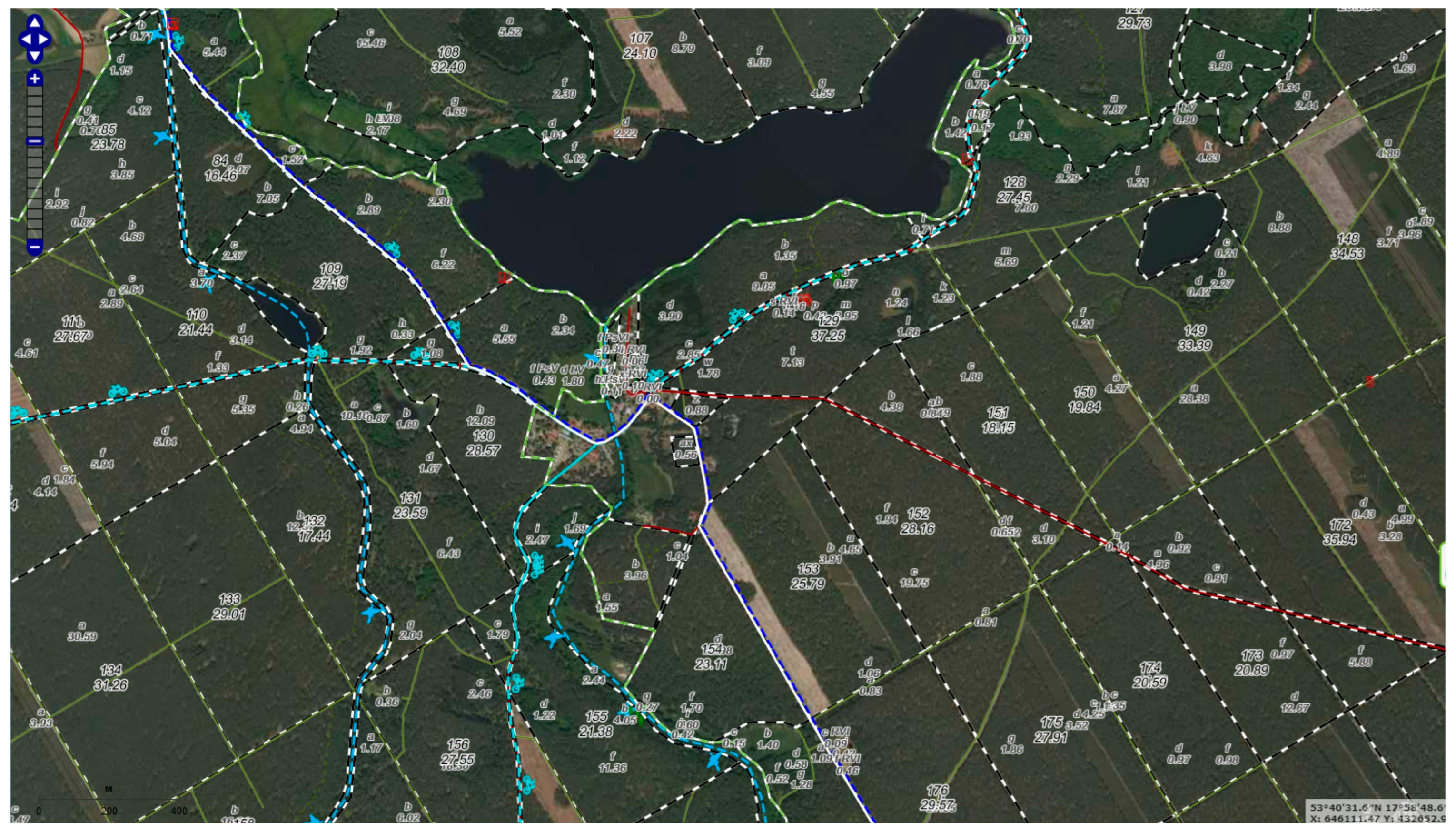
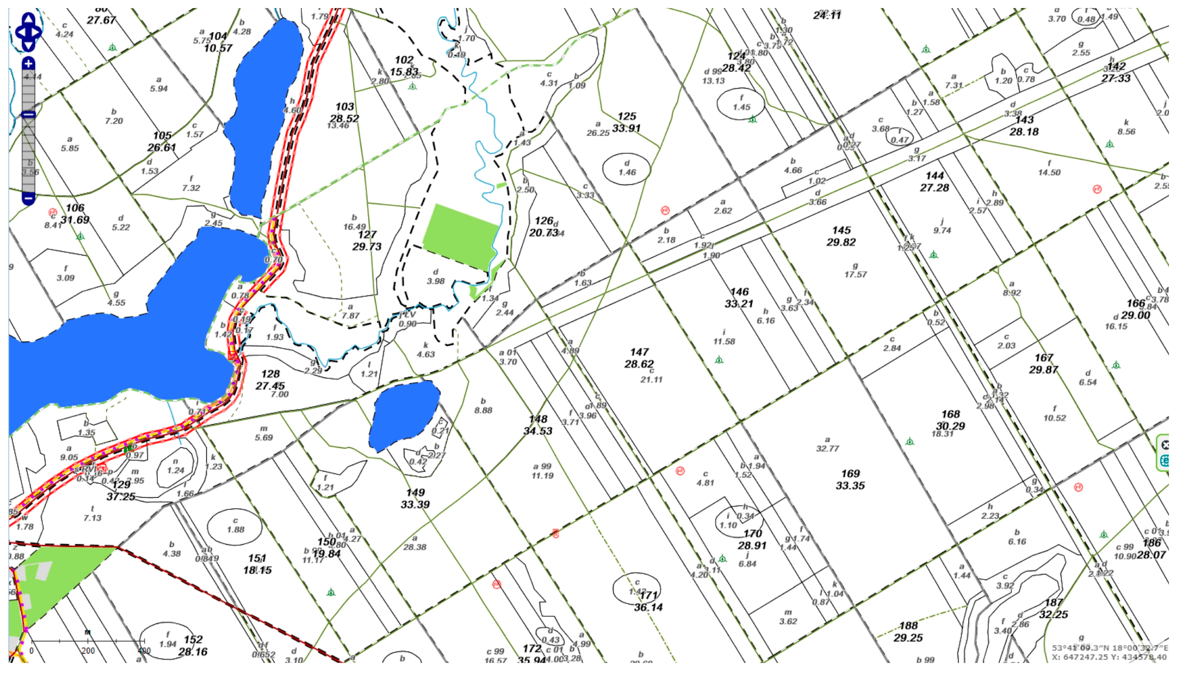
In 2003, ground and air laser scanning began in Polish forestry. As a result, the first website in the National Forest Holding—State Forests (PGL LP) was developed in 2007 [22,47]. Since the beginning of the 20th century, an essential element in popularizing remote sensing has been using aerial and satellite photos and other products in the form of orthophoto maps, digital maps, and vector IT layers for forest analyses. An example is a study commissioned by the General Directorate of State Forests to a team of scientists from the Agricultural University of Krakow on the usefulness of information obtained from aerial and satellite photos (QuickBird satellite, panchromatic aerial photos on a scale of 1:13,000, images of the AISA hyperspectral aerial scanner) as well as GPS techniques in the inventory. Currently, the production version is adapted to the latest versions of ArcMap [48,49]. Thanks to that, since 2008, all forests managed by the State Forests in Poland have numerical maps as a primary information source for strategic studies related to forest management (Figure 2 and Figure 3). These maps also provide other information, such as information on road networks, buildings, and tourist facilities [50]. It is worth emphasizing that, in 2011, BULiGL launched the Forest Data Bank, which collects all spatial data on Polish forests in one system [22,47]. At the turn of 2018 and 2019, it became available for public use as the mBDL [51] application.

2.3. Tourism in the Forest Areas in Poland

Rural areas offer great opportunities for all kinds of tourism, including ecotourism [13,20]. At the same time, the requirements related to the protection of the natural environment, respect for the animal world, and tourist absorption must be respected. This is very important, as the number of tourists staying in forests at one time should not lead to an imbalance in forest ecosystems. Ecotourism emphasizes minimizing negative impacts on the environment and supports environmental education. Tourism can be of particular importance in degraded forest areas that have previously suffered from various catastrophic events of both a natural (e.g., storms, gales, etc.) and anthropogenic (mainly fires) nature. It is in these areas in particular that tourism can provide rescue and be part of the non-productive function of forest ecosystems due to the nurturing of the environment and the education of tourists.
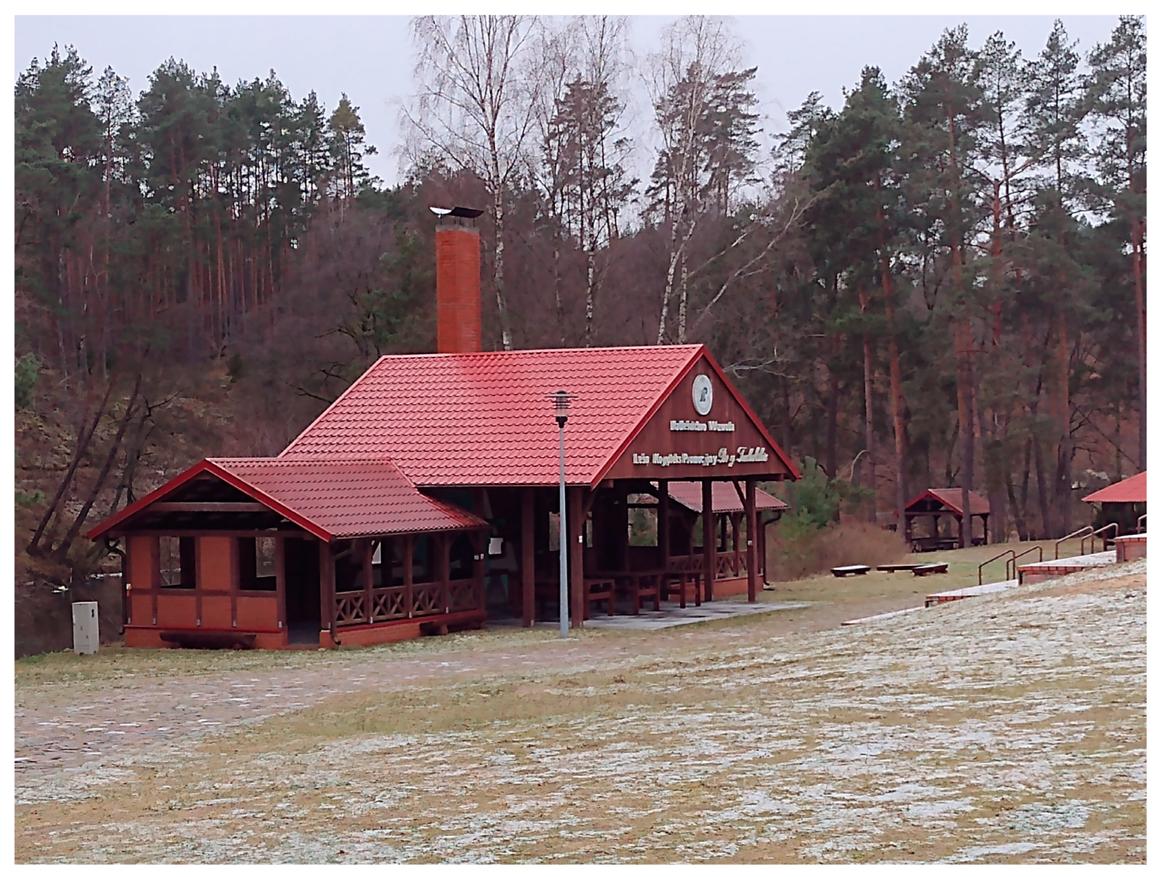
An additional advantage of forest areas, especially in Poland, is the creation of tourist facilities, including the creation of tourist trails, information boards, viewpoints, and towers, and even recreational-tourist infrastructure, as exemplified by the tourist management of Promotional Forest Complexes [52,53,54]—Figure 4. Tourists are gaining knowledge about the risks posed by climate change in forests. Modern information and communication technologies, including forest apps, are helping in this regard [36]. An example is the “Stay Overnight in the Forest” program launched in Poland on 1 May 2021, which is a new and authentic tourism and recreation initiative of the State Forests aimed at different groups of forest users [22].

3. Materials and Methods

3.1. Source Data and Methodology

This study’s temporal scope is from mid-2019 (i.e., the introduction of the pilot program on making forests available for bushcraft and survival activities in Poland) until the beginning of 2024. Thus, it covers when the State Forests program called “Stay Overnight in the Forest” related to dispersed camping in forests was in force. Remote sensing technology was used to assess the synergy of ecosystem and tourism services: high-resolution images (e.g., QuickBird, Ikonos or Google Maps) that enable visual interpretation of the earth’s surface, multispectral images (e.g., Landsat, Spot, IRS, or the new Sentinel series) that allow for the classification of terrain cover and environmental analysis, such as vegetation. These data can be processed and modeled in GISs, numerical maps, and orthophoto maps. Remote sensing was used as an alternative to traditional ground-based measurements to assess changes in the forest ecosystem and to evaluate the synergies of ecosystem services and tourism in the forests, e.g., the following (Table 1):
-
Fragments of the Numerical Forest Map (ver. 3.10.4) with selected thematic layers as map products of GIS program [50];
-
Interactive maps from the Forest Data Bank (BDL) [55] and the mBDL mobile application [51] on the ESRI OpenStreetMap substrate, combined with various thematic maps;
-
Orthophotos generated from the publicly available Geoportal.gov.pl service [56].
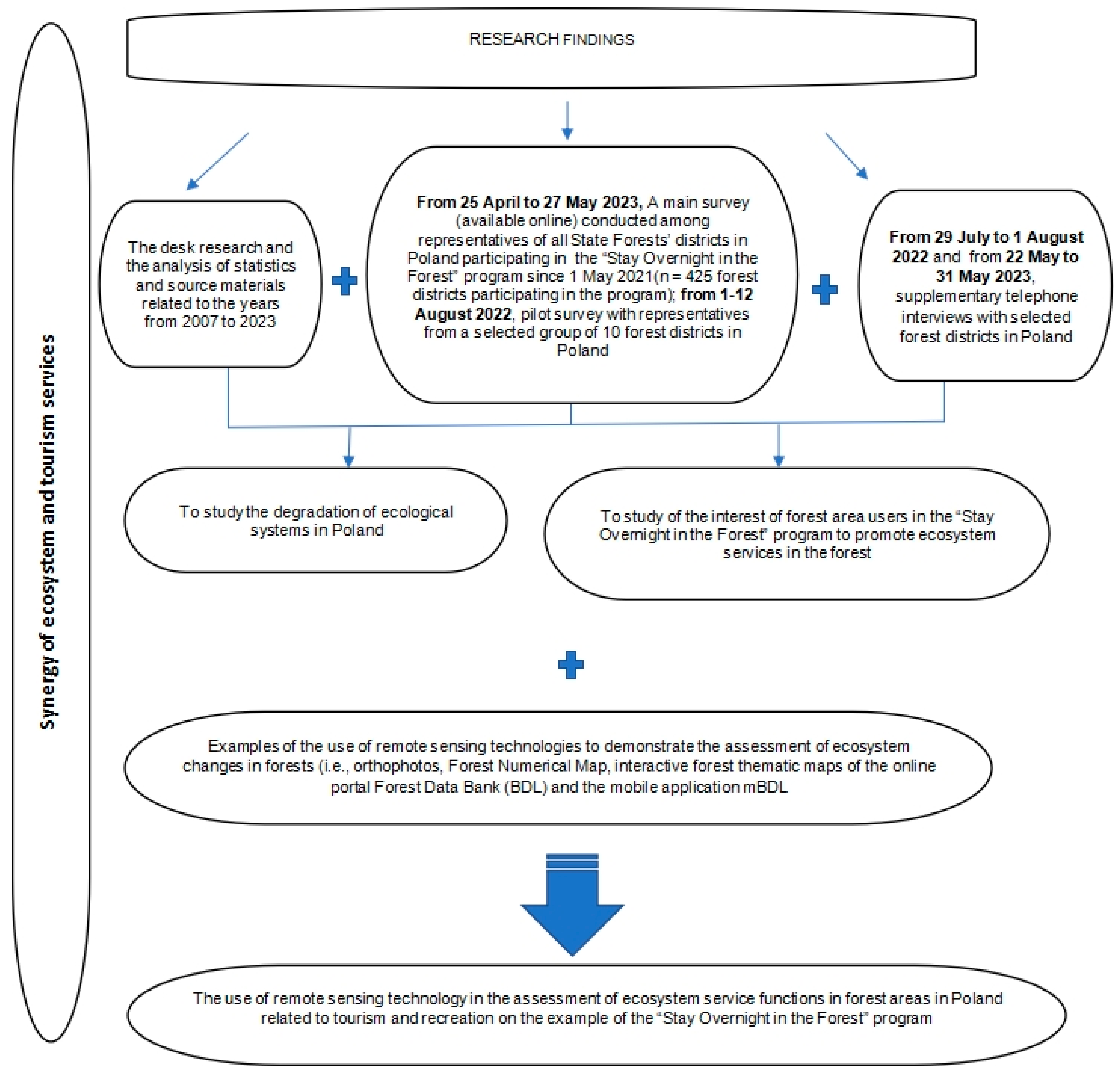
Additionally, online surveys were conducted using the Microsoft Forms platform (from 25 April 2023 to 27 May 2023) among representatives of all forest districts participating in implementing the “Stay Overnight in the Forest” program from 1 May 2021 (N = 425). This program is a crucial element of the contemporary tourist and recreational offer of the State Forests in Poland and influences the course of the ecosystem and tourist services in the forests. This study was preceded by testing a group of 10 representatives of forest districts from the Regional Directorate of State Forests in Toruń in 2022. An element complementing the leading survey research was telephone interviews with forest districts located within the Promotional Forest Complexes in Poland in 2022–2023. Out of 429 forest districts, 425 took part in this research. In this way, a total sample was used [59,60]. The total number of surveys was 349, constituting 82.1% of all forest districts authorized to survey. Of the surveyed forest districts, as many as 258 (75.4% of the total) are located close to cities, of which approximately 1/5 (i.e., 58) are located in the suburbs of large cities with over 100,000 inhabitants (Figure 5).
The analyses also took into account secondary sources and materials. Among them, the Act of 28 September 1991 on forests (Journal of Laws of 2023, item 1356, as amended [32], internal documents (e.g., decisions of the Director General of the State Forests [61,62,63,64]) and forest reports and statistics were of particular importance, prepared by the State Forests Information Centre or the State Forests Evaluation Centre on behalf of the General Directorate of State Forests in Poland [55,65]. The analyses used included, among others, forest netographic sources, i.e., resources of the home page of the State Forests [47], the mBDL mobile application [51], as well as the website the Forest Tourist Guide website [56]. “Geoportal.gov.pl”—the website [56,57]—was also particularly important, which acts as the central node of the “Spatial Information Infrastructure” in Poland, intermediating access to spatial data and related services, including various maps [66].

3.2. Study Area

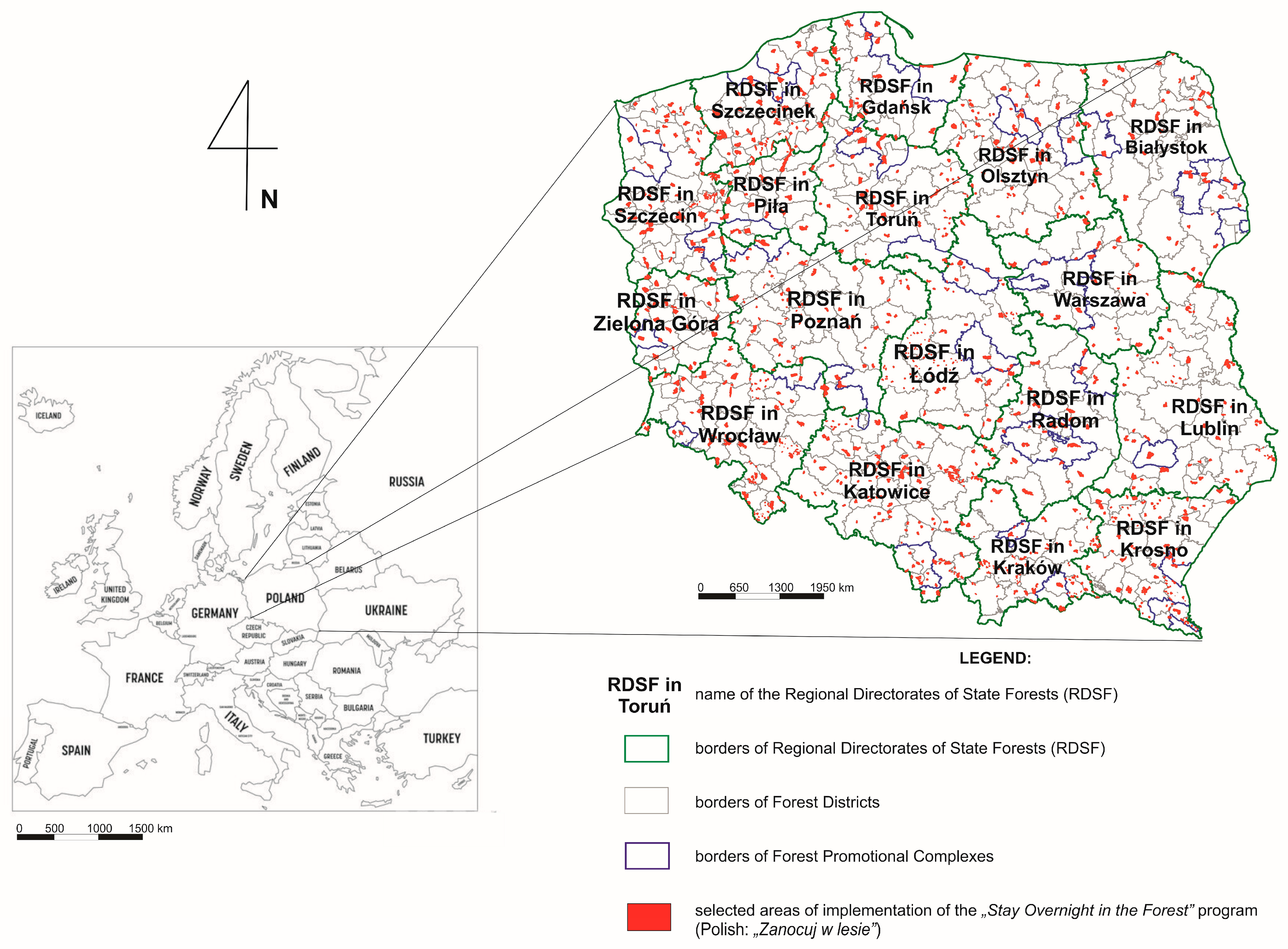
The spatial analysis concerned the area of forests owned by the State Treasury located within Poland’s administrative borders and managed by the National Forest Holding—State Forests. A total of 17 Regional Directorates of State Forests supervise these forests, with a total area of 7,091,400 ha divided into 429 forest districts (as of 2024). The forest area in forest districts ranges from 10,000 ha or less (31 forest districts) to 30,100 ha or more (two forest districts). The subject of this study is the State Forests program called “Stay Overnight in the Forest”, which, from 1 May 2021, is a crucial element of the synergy of ecosystem and tourist services in Polish forests. The spatial scope of this research included 425 forest districts out of a total of 429 (Figure 6). Four forest districts (Białowieża, Browsk, Hajnówka, Drawsko) were excluded from the “Stay Overnight in the Forest” program for reasons of public safety. Additionally, from 1 March 2022, one forest district (Cisna) in agreement with the Polish Border Guard suspended the program until further notice due to the proximity of the border with Ukraine and the ongoing war with Russia there.

4. Results and Discussion

4.1. The Use of Remote Sensing to Evaluate the Degradation of Ecological Systems in Poland

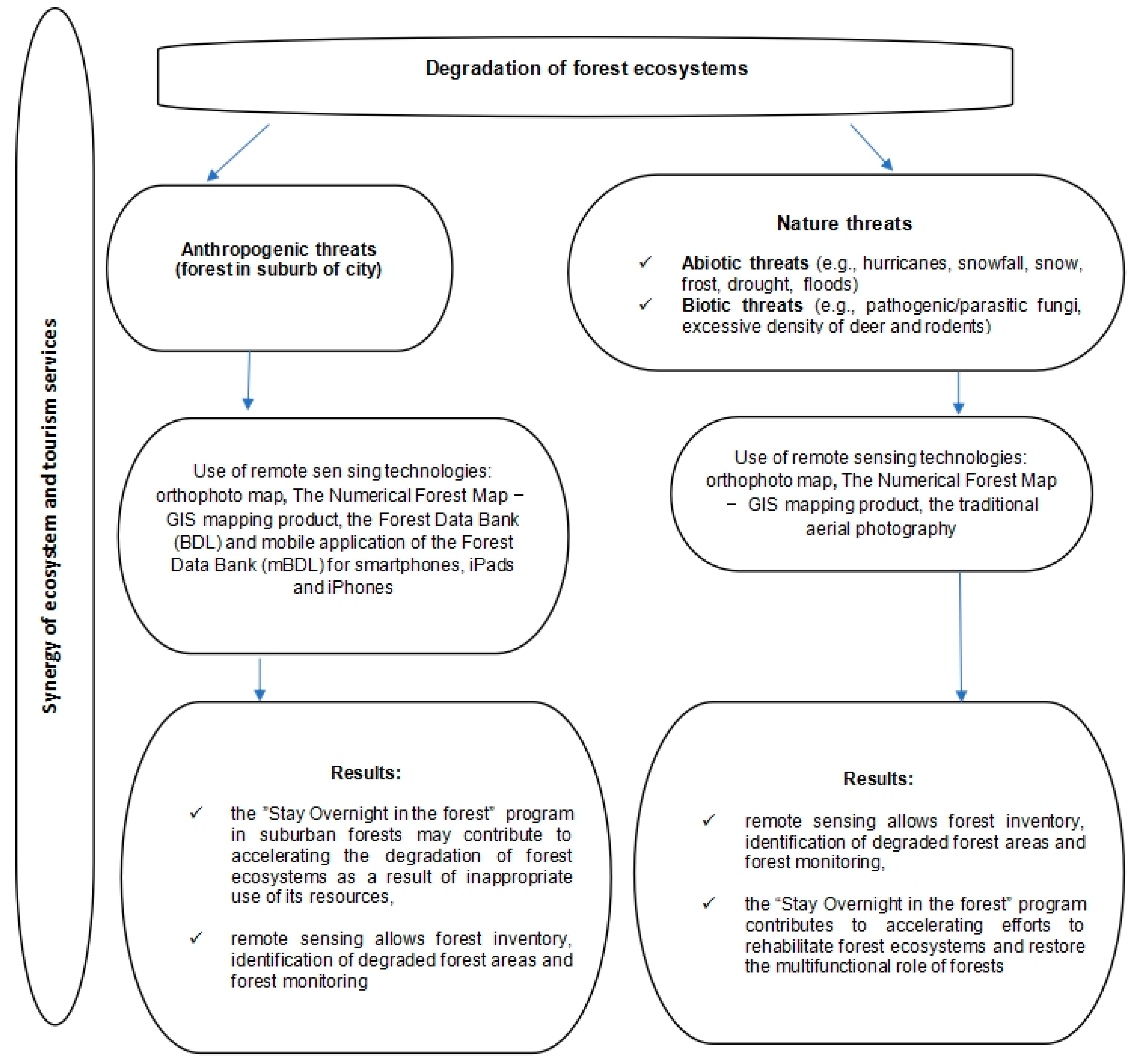
Forests in Poland are among the most endangered on the European continent, which, according to practitioners, is determined by the climate, insufficient rainfall, the dominance of flammable pine forests, and numerous threats related to human activity [31,46,67,68]. The area of forests in Poland is 9,143,000 ha, constituting 29.2% of the state’s total area. Industry and transport are essential sources of constant anthropogenic threats as they emit harmful dust and gases into the atmosphere, particularly sulfur and nitrogen oxides and fluorine compounds. These substances reduce the productivity and growth of forest stands by up to 30% and increase the susceptibility of trees to fungal diseases and the spread of certain insect species [68,69]. As foresters estimate, fires are also a significant threat to modern forests in Poland, as over 90% of fires with an established cause are human-induced (e.g., accidental fire, arson, littering) [31], many resulting from tourism and recreation in forests (Table 2).
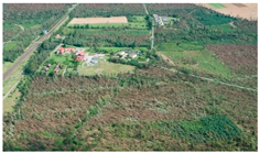
Most of the threats to forest ecosystems are area-specific, causing significant transformations in space (Figure 7). The use of aerial photos and orthophoto maps or satellite photos, as well as their analysis and interpretation, allows for the quick evaluation of damage in the event of, for example, hurricanes or fires in forest stands and help determine the scope of actions necessary to remove their effects [46]. A timely aerial photo or high-resolution satellite imaging, and, in some cases (especially of small-scale events), even non-metric images, can be invaluable when analyzing the effects of natural disasters, mainly forest inventories, by calculating the area and amount of losses incurred, planning the restoration of the post-disaster surface, or, in the case of floods, ongoing monitoring of the progress of damage [58].
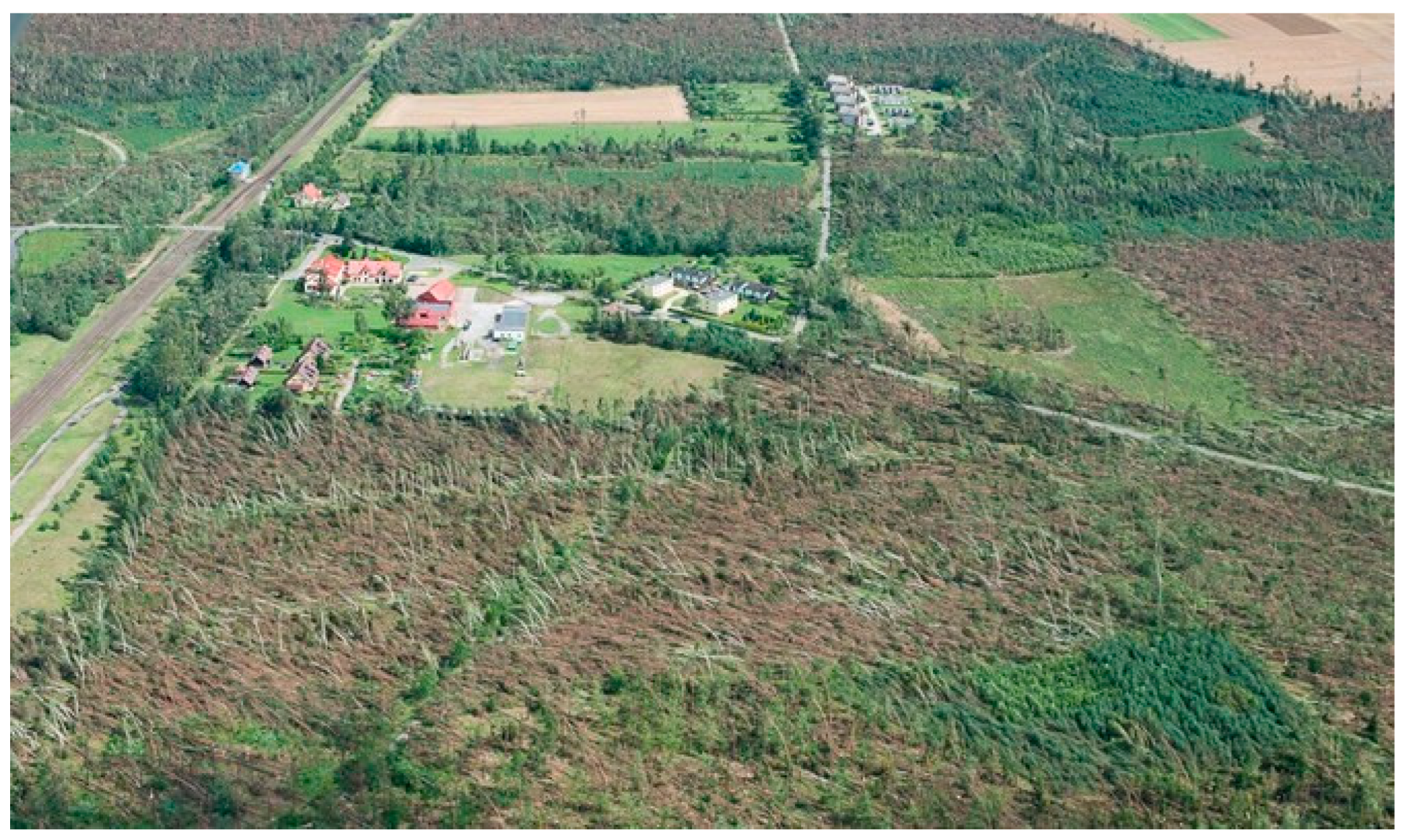
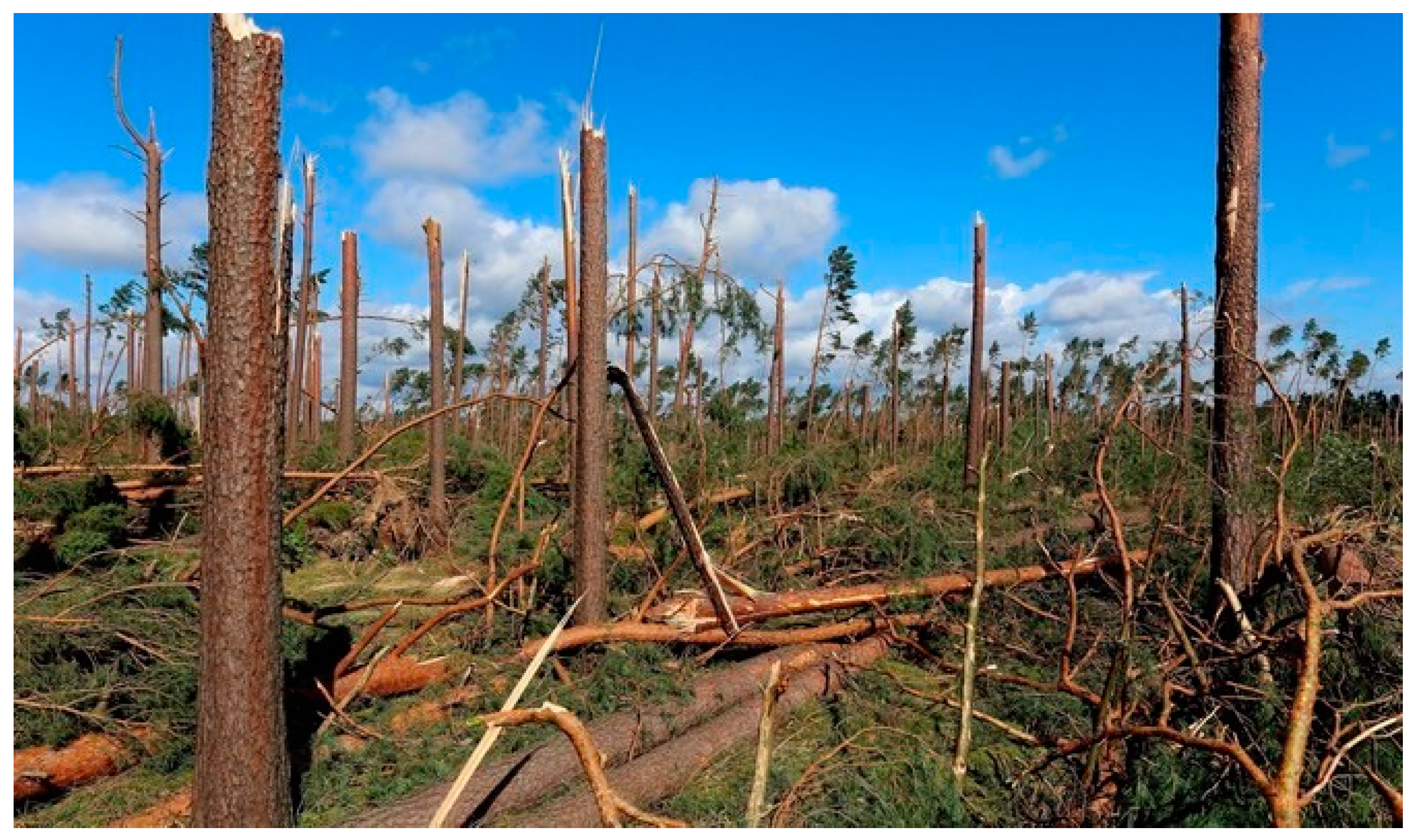
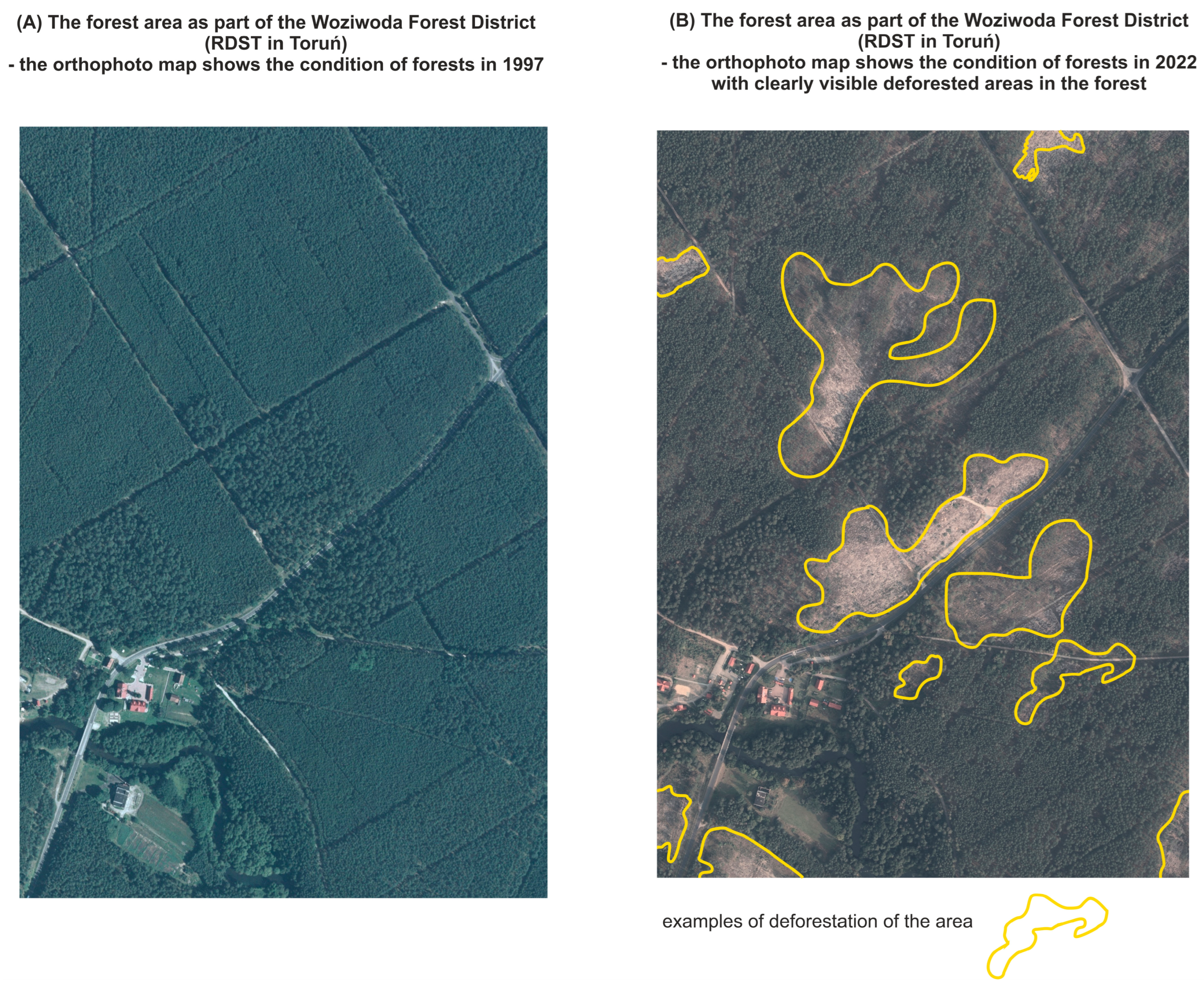
Excellent examples of the above are actions related to two ecosystem disasters within the Regional Directorate of State Forests in Toruń [53,58,68]. On 10–11 August 1992, the largest forest fire in the post-war history of Kujawsko-Pomorskie Voivodeship happened in the Cierpiszewo and Gniewkowo forest districts. About 3000 ha of forests burned down in one day. Over the next four years, foresters cleaned up the fire site and planted a new forest, covering the traces of the natural disaster. Another ecosystem degradation, the “disaster of the century”, occurred on 11–12 August 2017. The storm and hurricane winds of over 150 km/h damaged approximately 80,000 ha of forests throughout Poland, from Lower Silesia through Wielkopolska, Kujawy, Pomerania, to the Baltic coast. The most significant damage (over 5.1 million m3 of damaged trees) was in an area of 17,800 ha within seven forest districts in Toruń: Rytel (64% of the forest area destroyed), Czersk (48%), Runowo (41%), Przymuszewo (33%), Szubin (31%), Woziwoda (22%) and Tuchola (16%) (Figure 8 and Figure 9).

4.2. Synergy of Ecosystem and Tourism Services on the Example of the “Stay Overnight in the Forest” Program

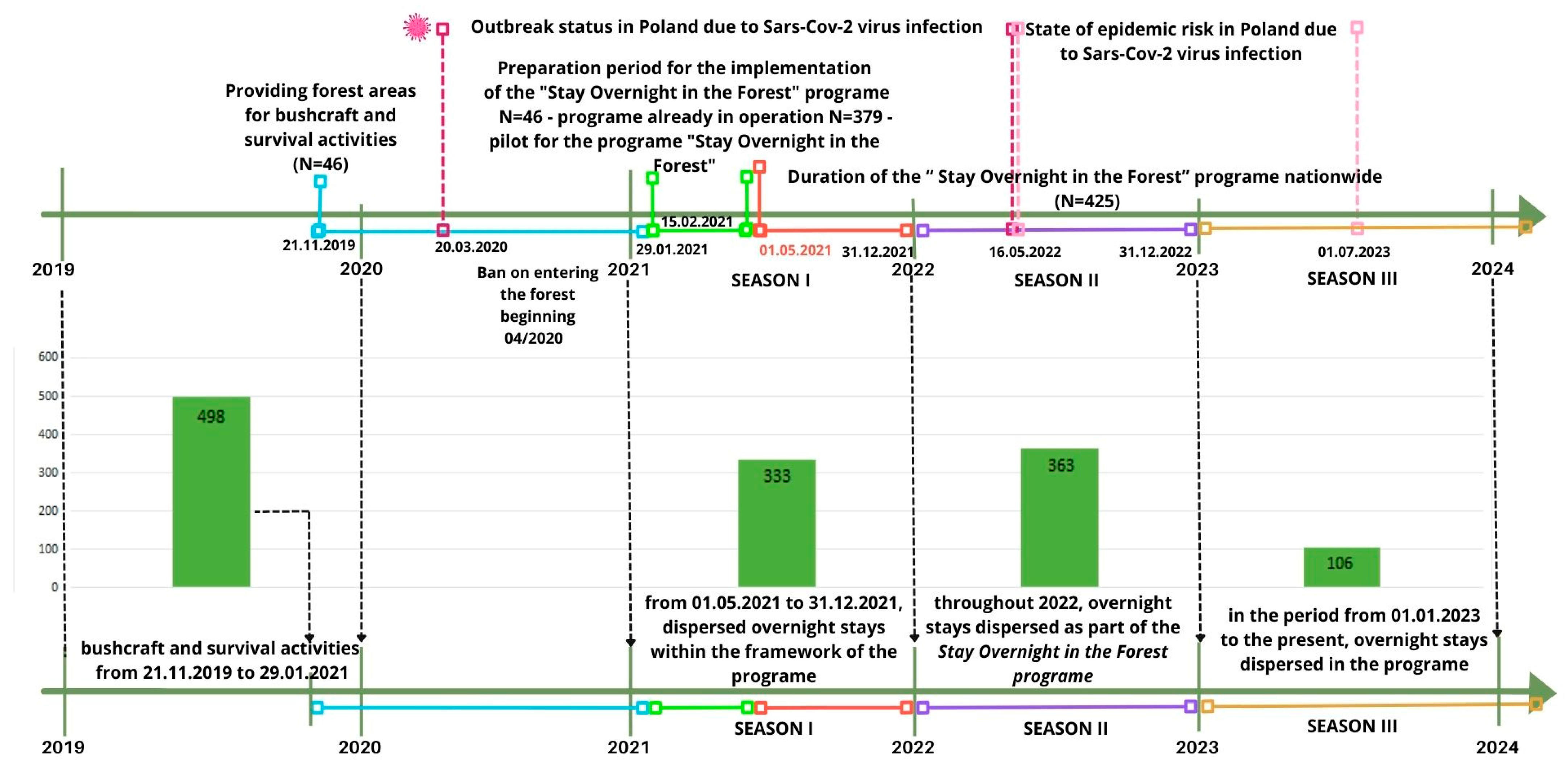
In Poland, since 2004, Forest Promotional Complexes (LKPLKPs) have been established, following the Canadian and Scandinavian models. These compact forest areas are part of one or several forest districts, which promote the pro-ecological state policy and sustainable forest management, support scientific research, conduct public education, and provide tourist services [31,32,70]. As of 2024, there are 25 Promotional Forest Complexes in Poland with a total area of approximately 1,275,000 ha, including approximately 1,187,000 ha managed by the National Forest Holding—State Forests, which constitutes about 13% of the forest area of Poland and approximately 16.8% of the area of the State Forests [54]. Forest Promotional Complexes became a testing ground for implementing pilot social programs regarding ecosystem and tourism services before they were implemented throughout the country [53,54]. An example of such activities of the State Forests was the introduction of a pilot program for making forests available for bushcraft and survival activities in 46 Forest Districts between 21 November 2019 and 29 January 2021. The program was based on the provisions of Decision No. 155 of the Director General of the State Forests of 21 October 2019. The pilot examined whether the assumed method of designating and using selected forest areas intended for survival and bushcraft is correct and whether these activities have affected the areas’ conditions [61,62].
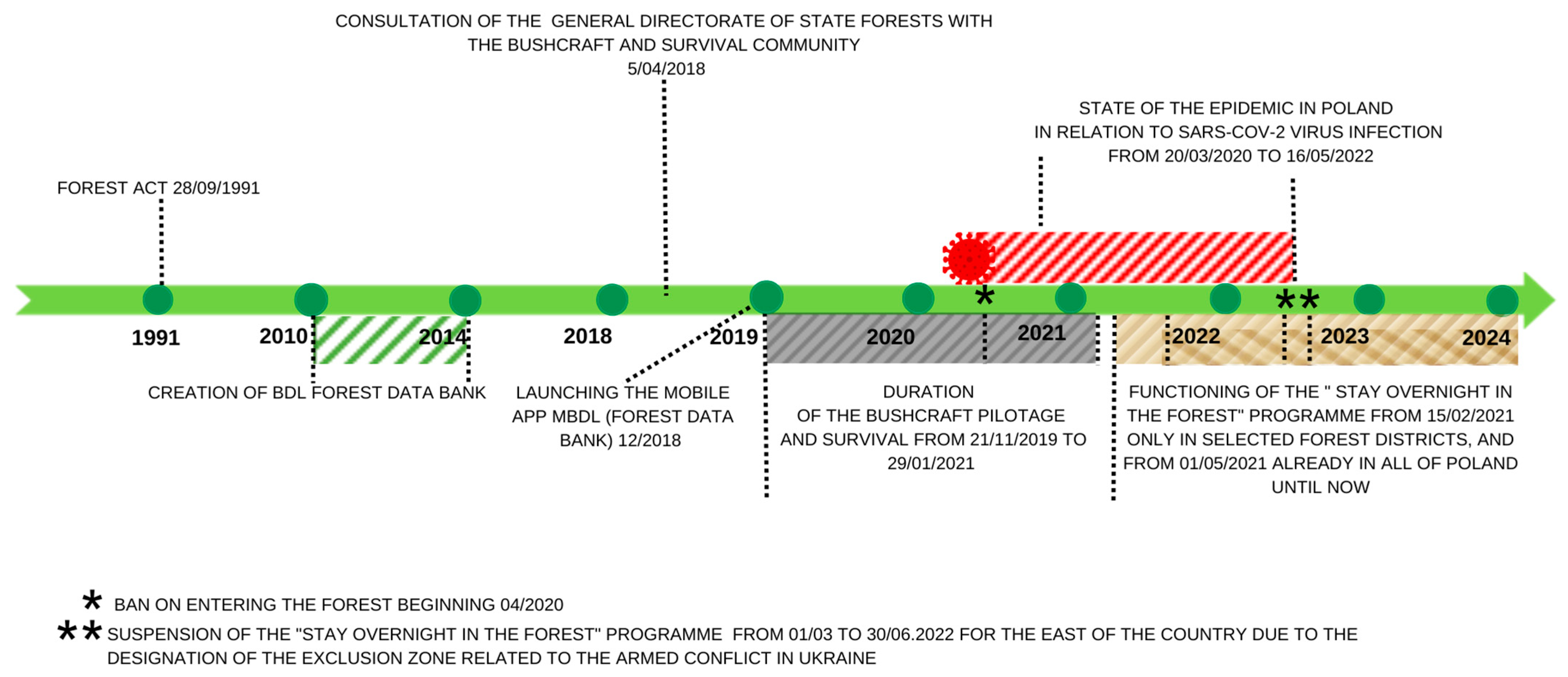
The outbreak of the global SARS-CoV-2 pandemic at the beginning of 2020 and the need to completely isolate societies meant that, on 20 March 2020, a state of the epidemic and the so-called “lockdown” were introduced (Regulation of the Minister of Health of 20 March 2020 on the announcement of a state of the epidemic in the Republic of Poland [71]). In this situation, it turned out that forest areas and forests became the only places (under the law at that time) that allowed society to leave their homes and regenerate their mental and physical strength away from large groups of people (Figure 10).
Positive audit results related to the implementation of the pilot project of making forest areas available for bushcraft and survival activities [65] made foresters aware of the alternative and beneficial importance of forests in providing ecosystem and tourist services for society, especially in crises as part of the implementation of the assumptions of the multifunctional forest management model (Figure 11).
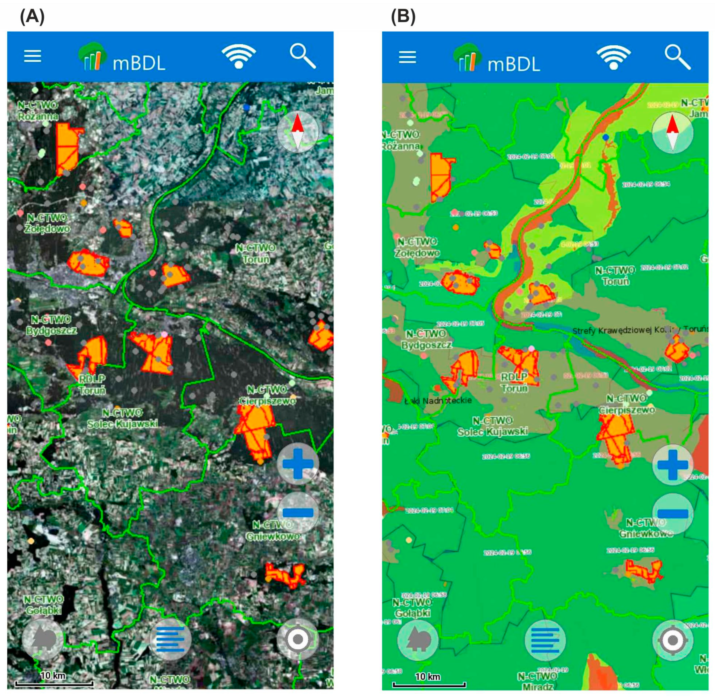
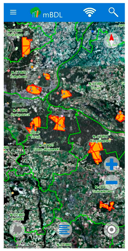
Under § 2 point 1 of Decision No. 12 of the Director General of the State Forests of 15 February 2021 on the launch of the “Stay Overnight in the Forest” program and the template regulations for the use of these places [63], this program is intended to allow people using the forest to have close and safe contact with nature, experience independence by preparing a place for overnight stay outdoors, developing an attitude of respect for the forest, knowledge about the forest, and the rules of using the forest. The program aims to enable dispersed camping in designated forest areas without camping infrastructure. It means that, from 1 May 2021, state forests have been made available for tourist and recreational activities throughout Poland, a total of approximately 643,000 ha of forest areas (the exception is currently the Białowieża, Browsk, Hajnówka, Drawsko Forest districts were excluded from the “Stay Overnight in the Forest” program for reasons of public safety and Cisna Forest District suspended the implementation of the program until further notice due to public security related to hostilities in Ukraine) [72,73,74]. It is worth emphasizing that this program is correlated with the Forest Data Bank [55], the website of the Forest Tourist Guide [52], and, from 2021, with the mobile application of the Forest Data Bank (mBDL) for smartphones, iPads and iPhones [51]. The latter provides, among others, interactive maps (i.e., forest thematic maps, including primary, tree stand, ownership, forest habitats, plant communities, and hunting; predefined raster backgrounds, e.g., topographic maps or aerial/satellite orthophoto maps; as well as maps from external WMS services)—Figure 12.
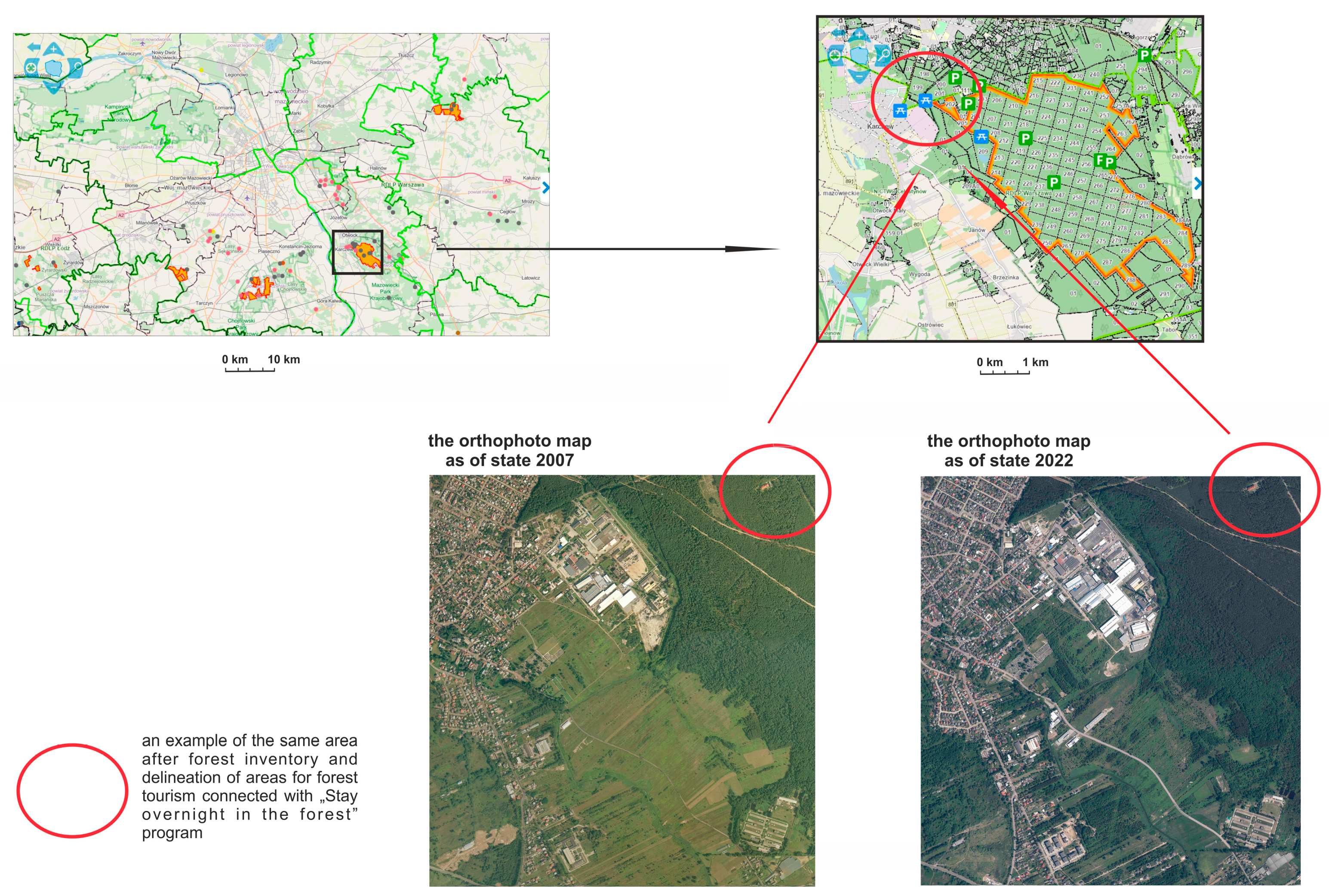
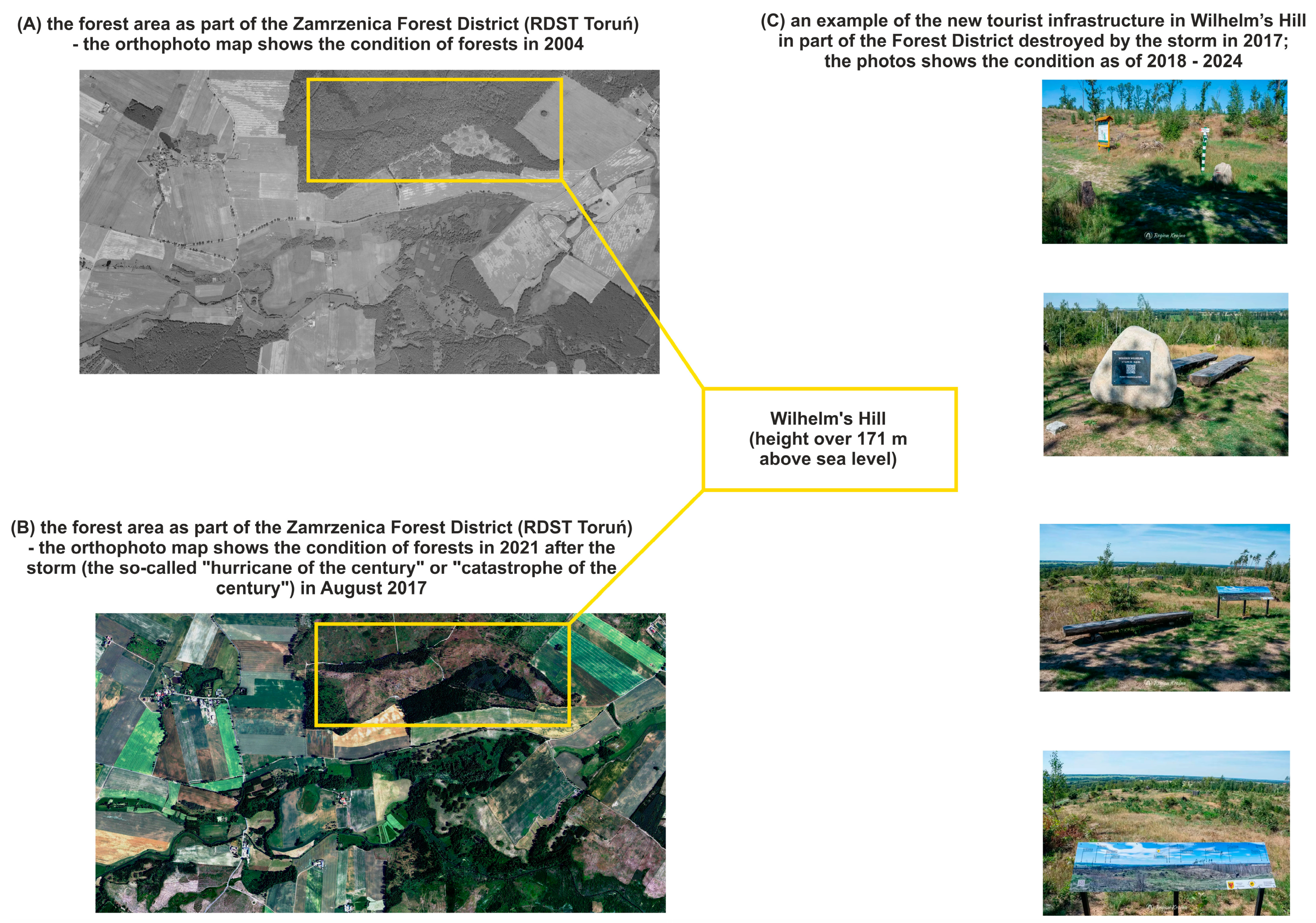
Thanks to the functioning of the multifunctional pro-ecological forest management model in Polish forests and the conduct of remote sensing analyses, it is possible to manage tourist and recreational traffic and allow the public to access forest ecosystems sustainably. As shown by surveys conducted on a group of 342 forest districts, which constituted four-fifths of the surveyed population (i.e., 80.5% of all those eligible for the survey), the remote sensing analysis carried out by the units made it a forest monitoring and inventory and possible to manage tourist and recreational traffic, thus allowing the public to access forest ecosystems sustainably. An essential effect of remote sensing analysis is the planning of new infrastructure investments (e.g., new shelters and forest parking lots, educational and cycle paths, or forest accommodation facilities) and the designation and provision of places for various forms of tourism and recreational activities in the forest (Figure 13 and Figure 14).

4.3. Tourists’ Interest in the “Stay Overnight in the Forest” Program

The use of remote sensing in ecosystem services allows the remote monitoring and analysis of forest ecosystems and their use for forest tourism development. It can monitor changes in the forest stand, track biodiversity, and assess damage caused by climate change. Remote sensing is also used to assess the impact of human activities on forest ecosystems in suburbs of cites and in peripheral areas. Since forests in peri-urban areas are particularly exposed to intensive tourism, the monitoring of forest areas by means of remote sensing tools also exists within the framework of the “Stay Overnight in the Forest” program. As forests in peri-urban zones are particularly vulnerable to intensive tourism, also within the framework of this program, it is important to monitor forest areas through the use of remote sensing tools, which enable the accurate and rapid location of areas that are vulnerable to anthropogenic degradation.
The survey conducted as part of this study shows that the highest interest in the “Stay Overnight in the Forest” program was recorded in forest districts located in the suburbs of cities (N = 258 of the respondents), including large agglomerations with over 100,000 inhabitants (N = 58) (Figure 15). This research showed that 44.2% of tourists from 151 surveyed forest districts, including 117 in suburbs and 34 on the outskirts of cities, show a high and very high level of interest in participating in the program. The respondents indicated that, when choosing a place to spend the night in the forest, they were guided by the proximity to their residence. The highest level of interest occurred during the bushcraft and survival pilot period and in the first and second periods after the official launch of the “Stay Overnight in the Forest” program (Figure 16).
Studies show that peri-urban areas are popular for the use of the “Stay Overnight in the Forest” program. All the more reason why they should be subject to an assessment of forest ecosystems using remote sensing tools (Figure 17).
Reports from forest districts [55,65] show that, since the beginning of the program, campers most often stayed one night (75% of users) and less often two nights (21%). When choosing an area for camping, besides the proximity of the forests to their place of residence, they also considered the possibility of using gas stoves and the attractiveness of places by lakes with access to parking facilities.
Forest ecosystem synergy refers to the interaction between human activities, such as tourism, and elements of living nature. This study has shown that it is possible to use forest areas degraded by storms, fires, and storms through tourism. This is only possible if the forests are properly managed by institutions set up for this purpose, e.g., in Poland by the National Forest Holding—State Forests. However, scientific studies have shown that, when forest areas are heavily degraded, such as forest fires in the Amazon, there is too much danger to human health to use them for tourism. According to the studies of [68,69], the threat and degradation of forests can be linked to biodiversity threats (insects, fungi). The application of forest protection treatments can exclude forests from tourism.
The rapid development of geoinformatic technologies, including remote sensing, is prompting a reconsideration of the desirability of using selected remote sensing data acquisition methods to assess ecosystem services and tourism services. It can be assumed that widespread access to high-quality aerial and satellite imagery will make the use of remote sensing data not only desirable but also necessary. This is evidenced by studies conducted in Germany [76,77], Canada [78], and Scandinavia [79].
Assessments of ecosystem services, such as stand inventories, have been made using remote forest data acquisition techniques. Researchers at the Pacific Forest Research Station in Canada relied on ITC (individual tree recognition) software, which is used to automatically determine the geoposition of trees in aerial images, as well as the size of their crowns and the quantitative composition of their species. Therefore, many authors [80,81] have advocated a change in the existing methods of assessing ecosystem services towards so-called precision forestry [82]. It is estimated that the annual value of ecosystem recreational services provided by forests ranges from 2 USD/ha to 279 USD/ha in different regions of the world [19]. Projections indicate that, by 2050, there will be an increase in the recreational value of forests, with the largest in China, North America, and Europe [17,83]. The annual recreational value of forests in Poland exceeds the revenue received by PGL LP from timber sales by 2.5–4 times [37,84]. Finland, Germany, Sweden, and Poland were classified as the countries with the best multifunctional forest management (Class I). The group of countries with the least developed multifunctional forest management (Class IV) included Belgium, Denmark, Ireland, Portugal, and Hungary. Conducting forest monitoring and then making this information available are therefore essential elements in gathering complete information on Europe’s forests [78,85].

5. Conclusions

The analysis presented in this paper of the usefulness of alternative methods, compared to ground surveys, for obtaining data on the forest proves that aerial (analog and digital) and satellite imagery, as well as GPS techniques, can be useful for assessing the functions of forest ecosystems and Tourism Services, including the determination of natural disasters (fires, bush damage). The analyses of orthophotos and aerial photographs of areas affected by natural disasters (hurricane of the century, fire, avalanche, storm) carried out in this study are innovative. And the introduction of tourism into degraded forest areas can contribute to accelerating restoration efforts, including both the improvement of forest ecosystems and the multifunctional role of forests. This is all the more so as the occurrence of extreme phenomena is set to increase, which is linked to ongoing climate change.
An example is the analyses made in this paper of orthophotos and aerial photographs of areas that have been affected by natural disasters (hurricane of the century, fire, avalanche, storm). The occurrence of extreme phenomena is set to increase, and this is linked to ongoing climate change. Examples of using remote sensing technologies to demonstrate the assessment of ecosystem changes in forests gives the opportunity for more efficient management and planning of forest complexes, including in the direction of tourism. A good example of this approach is the analysis of the pilot program of the State Forests in Poland on making forests available for bushcraft and survival-type activities and the “Stay Overnight in the Forest” program presented in this article, which proves that forest ecotourism can have a positive impact on forest ecosystems. In addition, the combination of modern photogrammetry and remote sensing tools with traditional numerical maps make it possible to obtain precise information about forest ecosystems. Remote sensing, in addition to traditional field and survey research, is a tool for assessing the synergy between ecosystem and tourism functions in forests.
From the recorded digital images, it is possible to obtain information about threats in forest ecosystems caused by natural disasters, such as windstorms and fires. PreciseThe precise provision of information about degraded forest areas can contribute to the more efficient management of forest reclamation works and the restoration of damaged stands. On the other hand, the rehabilitated forest can be a destination point for educational trails in forests.
As the forest districts’ interlocutors admit, although the fashion for spending the night in the forest is no longer as great as at the beginning of the program launch in 2021, the interest in the program persists, not only among people practicing qualified forms of survival and bushcraft but also among residents of large cities, men, between 25 and 45 years of age, who can benefit from access to the mBDL mobile application, which allows users to use forest thematic maps available for Android (supporting smartphones) and iOS systems supporting, e.g., iPhones and iPads (see Figure 10). It means that, on the one hand, remote sensing technology in forests allows forest districts to monitor the space and well-being of forest ecosystems. On the other hand, making its products available (i.e., topographic maps, orthophoto maps, satellite maps) to all forest users enables society to use forest resources safely and sustainably.
Summarizing the discussed research results and the experience of other authors, the following conclusions can be made:
-
Remote sensing is a very good source of information for assessing changes in forest ecosystems; nowadays, both orthophotos and satellite images are more readily available than back in the early 20th century. This is due to the widespread availability of geoservers on the Internet and the posting there of data from a great many aerial and satellite sensors. The main advantage of digital orthophotos in forestry is the determination of the boundaries of forest complexes and stands.
-
Remote sensing and photogrammetry should continue to be used in many departments of forestry management, such as the protection of forest ecosystems, forest use and management, forest inventory, and hunting.
-
The “Stay Overnight in the Forest” program concerns dispersed camping in the forest areas and is a contemporary example of building good relations and trust between the State Forests and the society as part of the promotion of the social role of the forest, especially the tourist and leisure function of forests in Poland.
-
The level of interest of forest users in the “Stay Overnight in the Forest” program in forest districts according to the division into Regional Directorates of State Forests (RDSF) in the suburb of cities of various sizes, including large agglomerations with over 100,000 inhabitants and outside their neighborhood (e.g., the areas of Promotional Forest Complexes)), are also considered a key factor in this regard.

Author Contributions

Conceptualization, M.K.-A., P.E.-J., and A.J.-T.; methodology, M.K.-A. and P.E.-J.; software, M.K.-A., P.E.-J., and A.J.-T.; validation, M.K.-A., P.E.-J., and A.J.-T.; formal analysis, M.K.-A., P.E.-J., and A.J.-T.; investigation, M.K.-A., P.E.-J., and A.J.-T.; resources, M.K.-A., P.E.-J., and A.J-T.; data curation, M.K.-A. and P.E.-J.; writing—original draft preparation, M.K.-A., P.E.-J., and A.J.-T.; writing—review and editing, M.K.-A., P.E.-J., and A.J.-T.; visualization, M.K.-A. and P.E.-J.; supervision, M.K.-A., P.E.-J., and A.J.-T.; project administration, M.K.-A., P.E.-J., and A.J.-T.; funding acquisition, A.J.-T. All authors have read and agreed to the published version of the manuscript.

Funding

The publication of this paper was also cofinanced by Kazimierz Wielki University in Bydgoszcz (Poland).

Institutional Review Board Statement

Not applicable.

Informed Consent Statement

Not applicable.

Data Availability Statement

The original contributions presented in the study are included in the article, further inquiries can be directed to the corresponding author.

Acknowledgments

Thanks to the Director General of the State Forests in Poland and all representatives of forest districts who participated in implementing the “Stay Overnight in the Forest” program from 1 May 2021 for taking part in survey research and for individual phone interviews, which were conducted with selected forest districts both in 2022 (i.e., during the pilot survey) and in 2023, immediately after the closing of the main survey.

Conflicts of Interest

The authors declare no conflicts of interest.

References

  1. Aznar-Sánchez, J.A.; Belmonte-Ureña, L.J.; López-Serrano, M.J.; Velasco-Muñoz, J.F. Forest ecosystem services: An analysis of worldwide research. Forests 2018, 9, 453. [Google Scholar] [CrossRef]
  2. Tian, L.; Tao, Y.; Fu, W.; Li, T.; Ren, F.; Li, M. Dynamic simulation of land use/cover change and assessment of forest ecosystem carbon storage under climate change scenarios in Guangdong Province, China. Remote Sens. 2022, 14, 2330. [Google Scholar] [CrossRef]
  3. Gougeon, F.A. Towards Semi-Automatic Forest Inventories Using Individual Tree Crown (ITC) Recognition; Technology Transfer Note; Forestry Research Applications, Pacific Forestry Centre, Canadian Forest Service: Victoria, BC, Canada, 2000; 22; pp. 1–6. Available online: https://publications.gc.ca/collections/Collection/Fo29-47-22-2000E.pdf (accessed on 8 April 2024).
  4. Dickson, E.; Franklin, S.E.; Moskal, L.M. Monitoring of Forest Biodiversity Using Remote Sensing: Forest Stand (High Spatial Resolution) Protocol and Examples; Alberta Biodiversity Monitoring Institute: Edmonton, AB, Canada, 1999; pp. 1–26. Available online: https://abmi.ca/home/publications/51-100/95 (accessed on 8 April 2024).
  5. Quattrochi, D.A.; Wentz, E.A.; Siu-Ngan Lam, N.; Emerson Ch, W. (Eds.) Integrating Scale in Remote Sensing and GIS; CRC Press: New York, NY USA, 2017; pp. 1–440. Available online: https://books.google.pl/books?hl=pl&lr=&id=bRcNDgAAQBAJ&oi=fnd&pg=PP1&dq=Quattochi+and+all+2017&ots=YgTzF4KNIe&sig=S2ccOGkJaqcwgu8UlLVqHJxUJE8&redir_esc=y#v=onepage&q&f=false (accessed on 8 April 2024).
  6. Andersen, H.E.; Reutebuch, S.E.; Schreuder, G.F. Automated individual tree measurement through morphological analysis of Lidar-based Canopy Surface Model. In Proceedings of the 1st International Precision Forestry Cooperative Symposium, Seattle, WA, USA, 17–20 June 2001; pp. 11–22. [Google Scholar]
  7. Leckie, D.G.; Gougeon, F.A.; Walsworth, N.; Paradine, D. Stand delineation and composition estimation using semi-automated individual tree crown analysis. Remote Sens. Environ. 2003, 85, 355–369. Available online: https://www.sciencedirect.com/science/article/abs/pii/S0034425703000130?via%3Dihub (accessed on 24 February 2025). [CrossRef]
  8. Forrester, D.I.; Bauhus, J. A review of processes behind diversity—Productivity relationships in forests. Curr. For. Rep. 2016, 2, 45–61. Available online: https://link.springer.com/article/10.1007/s40725-016-0031-2 (accessed on 8 April 2024). [CrossRef]
  9. Ren, S.; Yang, Q.; Liu, H.; Shen, G.; Zheng, Z.; Zhou, S.; Liang, M.; Zhou, Z.; Wang, X. The driving factors of subtropical mature forest productivity: Stand structure matters. Forests 2021, 12, 998. [Google Scholar] [CrossRef]
  10. Ivanova, N.; Fomin, V.; Kusbach, A. Experience of forest ecological classification in assessment of vegetation dynamics. Sustainability 2022, 14, 3384. [Google Scholar] [CrossRef]
  11. Paluš, H.; Krahulcová, M.; Parobek, J. Assessment of forest certification as a tool to support forest ecosystem services. Forests 2021, 12, 300. [Google Scholar] [CrossRef]
  12. Gonia, A.; Jezierska-Thöle, A. Sustainable Tourism in Cities—Nature Reserves as a ‘New’ City Space for Nature-Based Tourism. Sustainability 2022, 14, 1581. [Google Scholar] [CrossRef]
  13. Häyhä, T.; Franzese, P.P.; Paletto, A.; Fath, B.D. Assessing, valuing, and mapping ecosystem services in Alpine forests. Ecosyst. Serv. 2015, 14, 12–23. [Google Scholar] [CrossRef]
  14. Kangas, A.; Astrup, R.; Breidenbach, J.; Fridman, J.; Gobakken, T.; Korhonen, K.T.; Nord-Larsen, T.; Næsset, E.; Olsson, H. Remote sensing and forest inventories in Nordic countries—Roadmap for the future. Scand. J. For. Res. 2018, 33, 397–412. [Google Scholar] [CrossRef]
  15. Costanza, R.; d’Arge, R.; de Groot, R.; Farber, S.; Grasso, M.; Hannon, B.; Limburg, K.; Naeem, S.; O’Neill, R.V.; Paruelo, J.; et al. The value of the world’s ecosystem services and natural capital. Ecol. Econ. 1998, 387, 3–15. [Google Scholar] [CrossRef]
  16. Leckie, D.G.; Gougeon, F.A.; Sturrock, R.N.; Paradine, D. Detection and assessment of trees with Phellinus weirii (laminated root rot) using high resolution multi-spectral imagery. Can. J. Remote Sens. 2004, 25, 793–818. [Google Scholar] [CrossRef]
  17. State of Europe’s Forests 2020, Ministerial Conference on the Protection of Forests in Europe—FOREST EUROPE Liaison Unit Bratislava, Slovak Republic. 2020, pp. 1–392. Available online: https://foresteurope.org/wp-content/uploads/2016/08/SoEF_2020.pdf (accessed on 24 February 2025).
  18. Willis, K.S. Remote sensing change detection for ecological monitoring in United States protected areas. Biol. Conserv. 2015, 182, 233–242. [Google Scholar] [CrossRef]
  19. Ninan, K.N.; Inoue, M. Valuing forest ecosystem services: What we know and what we don’t. Ecol. Econ. 2013, 93, 137–149. [Google Scholar] [CrossRef]
  20. Gössling, S. Ecotourism: A means to safeguard biodiversity and ecosystem functions? Ecol. Econ. 1999, 29, 303–320. [Google Scholar] [CrossRef]
  21. Jezierska-Thöle, A.; Gwiaździńska-Goraj, M.; Dudzińska, M. Environmental, Social, and Economic Aspects of the Green Economy in Polish Rural Areas—A Spatial Analysis. Energies 2022, 15, 3332. [Google Scholar] [CrossRef]
  22. Kozłowska-Adamczak, M.; Essing-Jelonkiewicz, P.; Jezierska-Thöle, A. Leveraging Information and Communication Technologies in Forest Ecotourism: A Case Study from Poland. Sustainability 2024, 16, 56. [Google Scholar] [CrossRef]
  23. Daily, G.C.; Matson, P.A. Ecosystem services: From theory to implementation. Proc. Natl. Acad. Sci. USA 2008, 105, 9455–9456. [Google Scholar] [CrossRef] [PubMed]
  24. MEA (Millennium Ecosystem Assessment). Ecosystems and Human Well-Being: Biodiversity Synthesis; World Resources Institute: Washington, DC, USA, 2005; pp. 1–137. Available online: https://www.millenniumassessment.org/en/Synthesis.html (accessed on 8 April 2024).
  25. TEEB (The Economics of Ecosystems and Biodiversity). Interim Report. 2010. European Communities. Available online: http://ec.europa.eu/environment/nature/biodiversity/economics/pdf/teeb_report.pdf (accessed on 8 April 2024).
  26. Solon, J. “Ecosystem Services” concept and its application in landscape-ecological studies. Probl. Ekol. Kraj. 2008, 21, 25–44. [Google Scholar]
  27. Mizgajski, A.; Bernaciak, A.; Kronenberg, J.; Roo-Zielińska, E.; Solon, J.; Śleszyński, J. Development of the ecosystem services approach in Poland. Econ. Environ. 2014, 4, 10–19. [Google Scholar]
  28. Mapping and Assessment of Ecosystems and Their Services. An analytical Framework for Ecosystem Assessments Under Action 5 of the EU Biodiversity Strategy to 2020. Discussion Paper—Final, April 2013 European Commision. Available online: https://publications.jrc.ec.europa.eu/repository/handle/JRC81328 (accessed on 8 April 2024).
  29. Kałamucka, W. Ecosystem services for tourism on the example of the Transboundary Biosphere Reserve Roztocze. Stud. Mater. CEPLw Rogowie 2017, 45, 90–96. [Google Scholar]
  30. Józefecka, M. European Union Forestry Strategy and Prospects for Further Development of Forest Tourism. Stud. Mater. Cent. Edukac. Przyr.-Leśnej 2011, 4, 329–332. [Google Scholar]
  31. Szujecki, A. Leśne Kompleksy Promocyjne—Polska Koncepcja Tworzenia i Wdrażania Leśnictwa Wielofunkcyjnego; Oficyna Wydawnicza FOREST: Warszawa, Poland, 2013; pp. 1–247. [Google Scholar]
  32. Forest Act of September 28, 1991 (Journal of Laws of 2023, Item 1356, as Amended). Available online: https://isap.sejm.gov.pl/isap.nsf/download.xsp/WDU19911010444/U/D19910444Lj.pdf (accessed on 8 April 2024).
  33. The National Environmental Policy 2030, 2019, Annex to the Resolution No. 67 of the Council of Ministers of 16 July 2019 (Item 794), Ministry of Climate, Warsaw, Poland. Available online: https://bip.mos.gov.pl/strategie-plany-programy/polityka-ekologiczna-panstwa/polityka-ekologiczna-panstwa-2030-strategia-rozwoju-w-obszarze-srodowiska-i-gospodarki-wodnej/ (accessed on 8 April 2024).
  34. Available online: https://www.lasy.gov.pl/pl/informacje/aktualnosci/polityka-ekologiczna-panstwa-2030 (accessed on 8 April 2024).
  35. Płotkowski, L.; Zając, S. Opracowanie Modelu Wielofunkcyjnej Gospodarki Leśnej w Regionie Rolniczym; Instytut Badawczy Leśnictwa Zakład Ekonomiki i Polityki Leśnej: Warszawa, Poland, 2004. [Google Scholar]
  36. Gołos, P. The economics of recreation and tourism in Polish forests. Leśne Pr. Badaw. (For. Res. Pap.) 2011, 72, 241–251. [Google Scholar] [CrossRef]
  37. Bartczak, A.; Lindhejm, H.; Navrud, S.; Zandersen, M.; Żylicz, T. Valuing forest recreation on the national level in a transition economy: The case of Poland. For. Policy Econ. 2008, 10, 467–472. [Google Scholar] [CrossRef]
  38. McHarg, I.L. Design with Nature; Doubleday/Natural History Press: New York, NY, USA, 1969; pp. 1–197. [Google Scholar]
  39. Gwiaździńska-Goraj, M.; Jezierska-Thole, A. Functional Changes of the Rural Areas in Poland. Case Study: Warmińsko-Mazurskie Voivodeship. J. Settl. Spat. Plan. 2013, 4, 53–58. Available online: https://geografie.ubbcluj.ro/ccau/jssp/arhiva_1_2013/06JSSP012013.pdf (accessed on 8 April 2024).
  40. Śleszyński, P. Expected traffic speed in Poland using Corine land cover, SRTM-3 and detailed population places data. J. Maps 2013, 11, 245–254. [Google Scholar] [CrossRef]
  41. Werner, P. Introduction to Geographical Information Systems; Wydawnictwo UW: Warszawa, Poland, 1992. [Google Scholar]
  42. Gaździcki, J. Leksykon Geomatyczny—Lexicon of Geomatics; Polskie Towarzystwo Informacji Przestrzennej: Warszawa, Poland, 2002; pp. 1–78. [Google Scholar]
  43. Sitek, Z. Fotogrametria Ogólna i Inżynieryjna; Państwowe Przedsiębiorstwo Wydawnictw Kartograficznych im. Eugeniusza Romera: Warszawa-Wrocław, Poland, 1992; pp. 1–751. [Google Scholar]
  44. Okła, K. Możliwości wykorzystania teledetekcji i fotogrametrii w Lasach Państwowych. In Geomatyka w Lasach Państwowych cz. I—Podstawy; Okła, K., Ed.; Centrum Informacyjne Lasów Państwowych, Generalna Dyrekcja Lasów Państwowych: Warszawa, Poland, 2010; pp. 419–436. Available online: https://www.geomatyka.lasy.gov.pl/media/geomatyka/Geomatyka_w_LP_cz_I.pdf (accessed on 30 April 2024).
  45. Olenderek, H.; Okła, K. System Informacji Przestrzennej w Leśnictwie, Konferencja Naukowo-Techniczna Polskiego Towarzystwa Informacji Przestrzennej, Zegrze, (12–14 June 2000). Available online: https://www.geomatyka.lasy.gov.pl/documents/25999395/0/4.3.1_konferencje+poza-3-PTIP-1.pdf/ (accessed on 30 April 2024).
  46. Zajączkowski, G.; Grzegorzewicz, T.; Wiśniewska, E. Metodyka pozyskiwania informacji teledetekcyjnej z ortofotomapy z użyciem programów stosowanych w Lasach Państwowych. In Geomatyka w Lasach Państwowych cz. II—Poradnik Praktyczny; Okła, K., Ed.; Centrum Informacyjne Lasów Państwowych, Generalna Dyrekcja Lasów Państwowych: Warszawa, Poland, 2013; pp. 168–176. Available online: https://www.geomatyka.lasy.gov.pl/documents (accessed on 8 April 2024).
  47. The Home Page of the State Forests. Available online: https://www.lasy.gov.pl/pl (accessed on 10 April 2024).
  48. Adamczyk, J. A digital forest map in tourism development of forest areas. Pol. Tow. Inf. Przestrz.—Rocz. Geomatyki 2012, 10, 7–19. [Google Scholar]
  49. Available online: https://www.arcanagis.pl/leman-srodowisko-wspierajace-tworzenie-map-lesnych/ (accessed on 8 April 2024).
  50. LMN—Forest Numerical Map Program (ver. 3.10.4)—Closed Spatial Information System (Digital Forest Map System) of the State Forests in Poland; General Directorate of the State Forests in Poland: Warsaw, Poland, 2024.
  51. mBDL Application (ver. 1.19.3)—Forest Management and Forest Surveying Office’s App. Available online: https://play.google.com/store/apps/details?id=pl.gov.lasy.bdl&pcampaignid=web_share (accessed on 9 May 2024).
  52. Forest Tourist Guide Website (“Czas w las”). Available online: http://www.czaswlas.pl/ (accessed on 10 April 2024).
  53. Fronczak, K. Leśne Kompleksy Promocyjne—Las w Dziewiętnastu Odsłonach; Centrum Informacyjne Lasów Państwowych: Warszawa, Poland, 2007; pp. 1–308. [Google Scholar]
  54. Cieszewska, A.; Giedych, R. The development of tourism infrastructure concept of the Forest Promotional Complex Warsaw Forests—project’s assumptions. Stud. Mater. CEPL Rogowie 2011, 13, 317–322. [Google Scholar]
  55. Forest Data Bank (Bank Danych o Lasach). Available online: https://www.bdl.lasy.gov.pl/portal/ (accessed on 20 March 2024).
  56. “Geoportal.gov.pl—Website”. Available online: https://www.geoportal.gov.pl/ (accessed on 15 February 2024).
  57. Available online: https://mapy.geoportal.gov.pl/imap/Imgp_2.html?gpmap=gp0 (accessed on 15 February 2024).
  58. Available online: https://www.lasy.gov.pl/pl/informacje/aktualnosci/najwieksza-taka-kleska-w-historii-polskich-lasow (accessed on 20 February 2024).
  59. Frankfort-Nachmias, C.; Nachmias, D. Research Methods in Social Sciences (Metody Badawcze w Naukach Społecznych); ZYSK i S-KA Wydawnictwo: Poznań, Poland, 2001; pp. 1–615. [Google Scholar]
  60. Runge, J. Metody Badań w Geografii Społeczno-Ekonomicznej, Element Metodologii, Wybrane Narzędzia Badawcze, Wyd; Uniwersytetu Śląskiego: Katowice, Poland, 2006; pp. 21–26. [Google Scholar]
  61. Decyzja nr 155 Dyrektora Generalnego Lasów Państwowych z dn. 21.10.2019 r. w sprawie uruchomienia pilotażu udostępnienia obszarów leśnych celem uprawiania aktywności typu bushcraft i surwiwal oraz wprowadzenia wzoru regulaminu korzystania z tych miejsc. Available online: https://www.lasy.gov.pl/pl/publikacje/biuletyn-informacyjny-lasow-panstwowych/2019/bilp-12-2019-r.pdf (accessed on 28 February 2024).
  62. Decyzja nr 107 Dyrektora Generalnego Lasów Państwowych z dnia 25.09.2020 r. w sprawie zmiany Decyzji nr 155 z dnia 21.10.2019 r. w sprawie uruchomienia pilotażu udostępnienia obszarów leśnych celem uprawiania aktywności typu bushcraft i surwiwal oraz wprowadzenia wzoru regulaminu korzystania z tych miejsc. Available online: https://www.lasy.gov.pl/pl/publikacje/biuletyn-informacyjny-lasow-panstwowych/2020/bilp-11-2020-r.pdf (accessed on 28 February 2024).
  63. Decyzja nr 12 Dyrektora Generalnego Lasów Państwowych z dnia 15.02.2021 r. w sprawie uruchomienia programu “Zanocuj w lesie” oraz wzoru regulaminów korzystania z tych miejsc. Available online: https://www.lasy.gov.pl/pl/publikacje/biuletyn-informacyjny-lasow-panstwowych/2021/bilp-3-2021.pdf (accessed on 28 February 2024).
  64. Decyzja nr 46 Dyrektora Generalnego Lasów Państwowych z dnia 9.06.2022 r. w sprawie zmiany Decyzji nr 12 Dyrektora Generalnego Lasów Państwowych z dnia 15.02.2021 r. w sprawie uruchomienia programu „Zanocuj w lesie” oraz wzoru regulaminów korzystania z tych miejsc. Available online: https://www.gov.pl/web/dglp/zarzadzenia-i-decyzje (accessed on 28 February 2024).
  65. Szostakowska, M.; Jeleń, M. Ewaluacja Programu “Zanocuj w lesie” Lasów Państwowych—Raport Końcowy; Ośrodek Ewaluacji Lasów Sp. z o.o.: Warszawa, Poland, 2022; pp. 1–52. Available online: https://www.lasy.gov.pl/pl/informacje/publikacje/informacje-statystyczne-i-raporty (accessed on 28 February 2024).
  66. Available online: https://www.lasy.gov.pl/turystyka/program-zanocuj-w-lesie/mapa-obszarow-objetych-programem-zanocuj-w-lesie (accessed on 20 March 2024).
  67. Available online: https://bydgoszcz.torun.lasy.gov.pl/ochrona-lasu (accessed on 15 February 2024).
  68. Chrzanowski, T.; Stopiński, M. Lasy Kujawsko-Pomorskie; Regionalna Dyrekcja Lasów Państwowych w Toruniu: Toruń, Poland, 2019; pp. 1–64. [Google Scholar]
  69. Okła, K. Leksykon terminów geomatycznych stosowanych w Lasach Państwowych. In Geomatyka w Lasach Państwowych cz. II—Poradnik Praktyczny; Okła, K., Ed.; Centrum Informacyjne Lasów Państwowych, Generalna Dyrekcja Lasów Państwowych: Warszawa, Poland, 2013. Available online: https://www.geomatyka.lasy.gov.pl/documents/25999395/0/Geomatyka+w+LP+cz.+II_ (accessed on 8 April 2024).
  70. Available online: https://www.lasy.gov.pl/pl/nasze-lasy/lesne-kompleksy-promocyjne (accessed on 2 March 2024).
  71. Regulation of the Minister of Health of March 20, 2020 on the Declaration of an Epidemic in the Territory of the Republic of Poland (Rozporządzenie Ministra Zdrowia z 20.03.2020 r. w sprawie ogłoszenia na obszarze Rzeczpospolitej Polskiej stanu epidemii)—Journal of Laws of 2020, Item 491, as Amended. Available online: https://www.gov.pl/web/rpa/rozporzadzenie-ministra-zdrowia-z-dnia-20-marca-2020-r-w-sprawie-ogloszenia-na-obszarze-rzeczypospolitej-polskiej-stanu-epidemii (accessed on 28 February 2023).
  72. Available online: https://www.lasy.gov.pl/pl/informacje/aktualnosci/wiecej-miejsc-dostepnych-w-ramach-201ezanocuj-w-lesie201d (accessed on 20 February 2024).
  73. Konieczny, A.A.; Gołos, P.; Sikora, A.T. Threats to the forest ecosystem and visitors in forest areas in the opinion of tourist in the Krynki Forest District. Sylwan 2020, 164, 25–31. [Google Scholar]
  74. Available online: https://www.lasy.gov.pl/pl/turystyka/program-zanocuj-w-lesie (accessed on 20 February 2024).
  75. “Portal Krajna.pl”-Web Portal. Available online: https://krajna.pl/miejsce/wzgorze-wilhelma/ (accessed on 28 February 2024).
  76. Schetar, D.; Kšthe, F. Bayerischer Wald: Lust auf Natur; DuMont Reiseverlag: Ostfildern, Germany, 2011; pp. 1–119. [Google Scholar]
  77. Bell, S.; Simpson, M.; Tyrväinen, L.; Sievänen, T.; Pröbstl, U. (Eds.) European Forest Recreation and Tourism: A Handbook; Taylor & Francis: London, UK, 2009. [Google Scholar] [CrossRef]
  78. Gaveau, D.L.; Hill, R.A. Quatifying canopy height underestimation by laser pulse penetration in smallfootprint airborne laser scanning data. Can. J. Remote Sens. 2003, 29, 650–657. [Google Scholar] [CrossRef]
  79. Fridman, J.; Holm, S.; Nilsson, M.; Nilsson, P.; Ringvall, A.H.; Ståhl, G. Adapting national forest inventories to changing requirements—The case of the Swedish national forest inventory at the turn of the 20th century. Silva Fenn. 2014, 48, 1–29. [Google Scholar] [CrossRef]
  80. Brandt, J.S.; Buckley, R.C. A global systematic review of empirical evidence of ecotourism impacts on forests in biodiversity hotspots. Curr. Opin. Environ. Sustain. 2018, 32, 112–118. [Google Scholar] [CrossRef]
  81. Bhuiyan, M.A.H.; Siwar, C.; Ismail, S.M.; Islam, R. Ecotourism development in recreational forest areas. Am. J. Appl. Sci. 2011, 8, 1116–1121. [Google Scholar] [CrossRef]
  82. Chiabai, A.; Travisi, C.M.; Markandya, A.; Ding, H.; Nunes, P.A.L.D. Economic Assessment of Forest Ecosystem Services Losses: Cost of Policy Inaction. Environ. Resour. Econ. 2011, 50, 405–445. [Google Scholar] [CrossRef]
  83. Dudek, T. Status and future of recreational use of forests in the opinion of employees of the State Forests NFH. Sylwan 2017, 161, 247–253. [Google Scholar] [CrossRef]
  84. Słupska, A.; Zawadzka, A. Assessment of multifunctional forest management in Poland compared to selected European Union countries. Agron. Sci. 2022, 77, 33–48. [Google Scholar] [CrossRef]
  85. Cesaro, L.; Gatto, P.; Pettenella, D. (Eds.) The Multifunctional Role of—Policies, Methods and Case Studies; European Forest Institute: Joensuu, Finland, 2008; pp. 1–380. Available online: https://efi.int/sites/default/files/files/publication-bank/2018/proc55_net.pdf (accessed on 28 February 2024).
Figure 1. The basic functions of ecosystems in forest areas (Source: Own study based on the following studies: [22,23,24,25,26,27]).
Sustainability 17 02060 g001
Figure 2. The orthophoto map of the vicinity of Woziwoda Forest District (in RDSF Toruń) combined with a Numerical Forest Map with a generated situational forest layer (shows, e.g., forest districts and forest divisions) and an infrastructure layer, including point objects (e.g., forestry objects, tourist objects, nature protection objects), linear tourist objects (e.g., tourist trails for hiking) (Source: Own study based on [50]). Adapted with permission from Ref. [50]. Copyright year 2024, copyright the General Directorate of the State Forests in Poland.
Sustainability 17 02060 g002
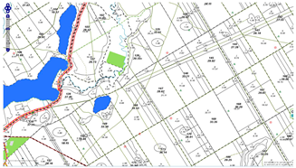
Figure 3. The Numerical Forest Map of the vicinity of Woziwoda Forest District (in RDSF Toruń) with a forestry and infrastructure layer combined with an economic forest map (Source: Own study based on [50]). Adapted with permission from Ref. [50]. Copyright year 2024, copyright the General Directorate of the State Forests in Poland.
Sustainability 17 02060 g003
Figure 4. Example of forest tourist infrastructure (i.e., camping and campervan site with full sanitary facilities, shelters, a place for a bonfire and barbecue, a volleyball pitch, etc.) in the Woziwoda Forest District (Regional Directorate of State Forests in Toruń), which is located within the boundaries of the Promotional Forest Complex “Bory Tucholskie”. Source: Own study based on forest inventory.
Sustainability 17 02060 g004
Figure 5. Research procedure (Source: Own elaboration).
Sustainability 17 02060 g005
Figure 6. Administrative division of Poland’s state-owned forests managed by the State Forest Holding—State Forests with the division into Forest Districts and Regional Directorates of State Forests taking into account the areas of implementation of the “Stay Overnight in the Forest” program (Source: Own study based on the following studies: [65,66]).
Sustainability 17 02060 g006
Figure 7. Landscape after the passage of the storm (the so-called “disaster of the century”) in the Rytel Forest District (RDSF Toruń, Poland) in August 2017. Source: Based on the study of [58].
Sustainability 17 02060 g007
Figure 8. Damage to forest ecosystems due to the passage of the storm in the Rytel Forest District (RDSF Toruń, Poland) in August 2017. Source: Based on the study of [58].
Sustainability 17 02060 g008
Figure 9. Comparison on aerial photographs (orthophoto maps) of changes in the structure and level of forest cover in the Woziwoda Forest District (RDSF Toruń), Poland, caused by the passage of a storm (the so-called “hurricane of the century” or “disaster of the century”) through the area in August 2017: (A) 1997 (dense forested area)—the state a few years before the disaster, and (B) 2022 (clearly noticeable deforested areas after former windfalls)—the state 5 years after the disaster (Source: Own compilation based on aerial photos generated from the studies of [56,57]).
Sustainability 17 02060 g009
Figure 10. Genesis of the creation of the program “Stay Overnight in the Forest”— synthesis (Source: Own elaboration).
Sustainability 17 02060 g010
Figure 11. Maps of the tourist and recreation offer of the State Forests: (A) The bushcraft and survival pilot running from 21 November 2019 to 29 January 2021. (B) The “Stay Overnight in the Forest” program from 01.05.2021 to date (as of 2024) (Source: Own elaboration based on the studies of [61,62,63,64,65,66,72]).
Sustainability 17 02060 g011
Figure 12. Examples of maps around the city Bydgoszcz with marked areas of the “Stay Overnight in the Forest” program included in the mBDL application, which was installed on a smartphone on the Android system (as of February 2024): (A) map basic mBDL with an ESRI aerial base map and a tourist development layer in the forest, and (B) forest thematic map (protected areas) with a tourist development layer in the forest (Source: Own elaboration based on aerial photos generated from the mBDL application [51]).
Sustainability 17 02060 g012
Figure 13. Use of orthophoto maps (from different time periods) for forest inventory and delineation of areas for forest tourism. An example of such an area (connected with the “Stay Overnight in the Forest” program) in the suburb of the city of Warsaw (the capital of Poland), Celestynów Forest District (RDSF in Warsaw), illustrated on interactive maps from the Forest Data Bank (BDL), created on the ESRI OpenStreetMap substrate combined with a map of forest tourism development. Source: Own elaboration based on the Forest Data Bank [55] and aerial photos generated from the studies of [55,56,57].
Sustainability 17 02060 g013
Figure 14. Use of analysis of aerial photographs (orthophotos) from different time periods for the forest inventory, planning, and management of forest areas for tourism and recreation—example of a fragment of Zamrzenica Forest District managed by RDSF in Toruń (Source: Own elaboration based on aerial photographs generated from the studies of [56,57] and the set of photographs from the “Portal Krajna.pl” web portal [75]). Adapted with permission from Ref. [75]. Copyright year 2018-2024, copyright “Portal Krajna.pl”—web portal.
Sustainability 17 02060 g014
Figure 15. The level of interest of forest users in the “Overnight in the Forest” program in forest districts according to the division into the Regional Directorates of State Forests (RDSFs) in (a) the suburb of cities; and (b) outside their neighborhood. Source: Own study based on survey conducted research, i.e., 342 correctly completed questionnaires.
Sustainability 17 02060 g015
Figure 16. Comparison of the number of official applications of the survival and bushcraft program (in the period from 21 November 2019 to 29 January 2021) and official applications of participants in the “Stay Overnight in the Forest” program (from 15 February 2021 only in selected forest districts) from 1 May 2021 to this day in all forest districts throughout Poland. Source: Own study based on survey conducted research, i.e., 342 correctly completed questionnaires.
Sustainability 17 02060 g016
Figure 17. Connection between remote sensing analysis results and types of threats. Source: Own study.
Sustainability 17 02060 g017
Table 1. Use of remote sensing technologies to assess changes in forest ecosystems in this publication.
The Type of Remote Sensing Material UsedSourceExamples
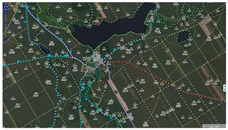
The orthophoto mapThe geoportal—polish open service with satellite images, orthophotos or topographic dataSustainability 17 02060 i001
The Forest Numerical Map (i.e., Digital Forest Map
Ver. 3.10.4)
(a) With forestry and infrastructure layer, including tourist linear objects and nature conservation objects combined with orthophoto map Sustainability 17 02060 i002
(b) With a forestry and infrastructure layer combined with an economic forest mapSustainability 17 02060 i003
The aerial photoThe National Forest Archive resourcesSustainability 17 02060 i004
The interactive maps (i.e., forest thematic maps; predefined raster backgrounds, e.g., topographic maps or aerial/satellite orthophoto maps, as well as maps from external WMS services)The Forest Data Bank (BDL)
and
mobile application of the Forest Data Bank (mBDL ver. 1.19.3) for smartphones, iPads and iPhones
Sustainability 17 02060 i005
Source: Own study based on the following: [47,50,51,52,55,56,57,58].
Table 2. Factors threatening forest ecosystems.
Group of FactorsOrigin of the FactorsThe Main Factor in the Emergence of Threats in the Forest EcosystemEffects of Damage to Forest Ecosystems
Biotic threatsFormed as
a result
of living organisms
pathogenic/parasitic fungiattacking tree seeds and seedlings in forest nurseries,
attacking forest crops and tree stands growing onformer agricultural land
excessive density of deer and rodentseating of fresh tree shoots, damage to trunks and trampling of forest crops and young forests
excess of harmful insects feeding both on the surface of trees and in their crowns, as well as under the barkgradations of harmful insects driving trees to sickness and even death
Abiotic threatsFormed as
a result of
the influence of inanimate factors
hurricanes, snowfall,
snow, frost,
drought, floods
effects depending on the type and severity of the phenomenon;
those of a disaster nature (with a catastrophic dimension) often cover large areas of forest areas, requiring the long-term involvement of foresters in eliminating damage and rebuilding the forest
Anthropogenic threatsFormed as
a result
of human activity
air pollution and water contamination due to the emission of harmful dust and gases into the atmosphere by industry and transportation spaceanthropogenic stress (so-called distress) causes ecosystem instability, generally reduces species diversity, and inhibits or reverses the development of forest succession,
reduce the productivity and growth of forest stands by up to 30%. Increasing the weakening of the tree stand
fires *fire starting, including failure by tourists to follow the basic rules of using fire in the forest and its immediate vicinity,
intentional arson,
leaving flammable garbage (e.g., glass bottles, etc.)
destruction of soil coverintentional destruction of litter and undergrowth, e.g., by digging up shrubs or moss, etc.
loosen the soil cover with quads
garbageformation of illegal garbage dumps,
incorrect (wrong) behavior of tourists related to throwing away garbage while staying and resting in the forest
tourist and recreational use
of the forest
incorrect (wrong) behavior of tourists and residents of suburbs of cities staying within the range of forest areas
* Foresters estimate that over 90% of fires in Poland with an established cause are caused by human fault (e.g., fire starting, arson, garbage, etc.). Source: Own study based on the studies of [22,31,68,69].
Disclaimer/Publisher’s Note: The statements, opinions and data contained in all publications are solely those of the individual author(s) and contributor(s) and not of MDPI and/or the editor(s). MDPI and/or the editor(s) disclaim responsibility for any injury to people or property resulting from any ideas, methods, instructions or products referred to in the content.