
Study on the Spatial Morphology of Ando Tibetan Traditional Villages in China: A Case of Traditional Villages in Huangnan Prefecture
 , ,
, ,
Abstract
1. Introduction
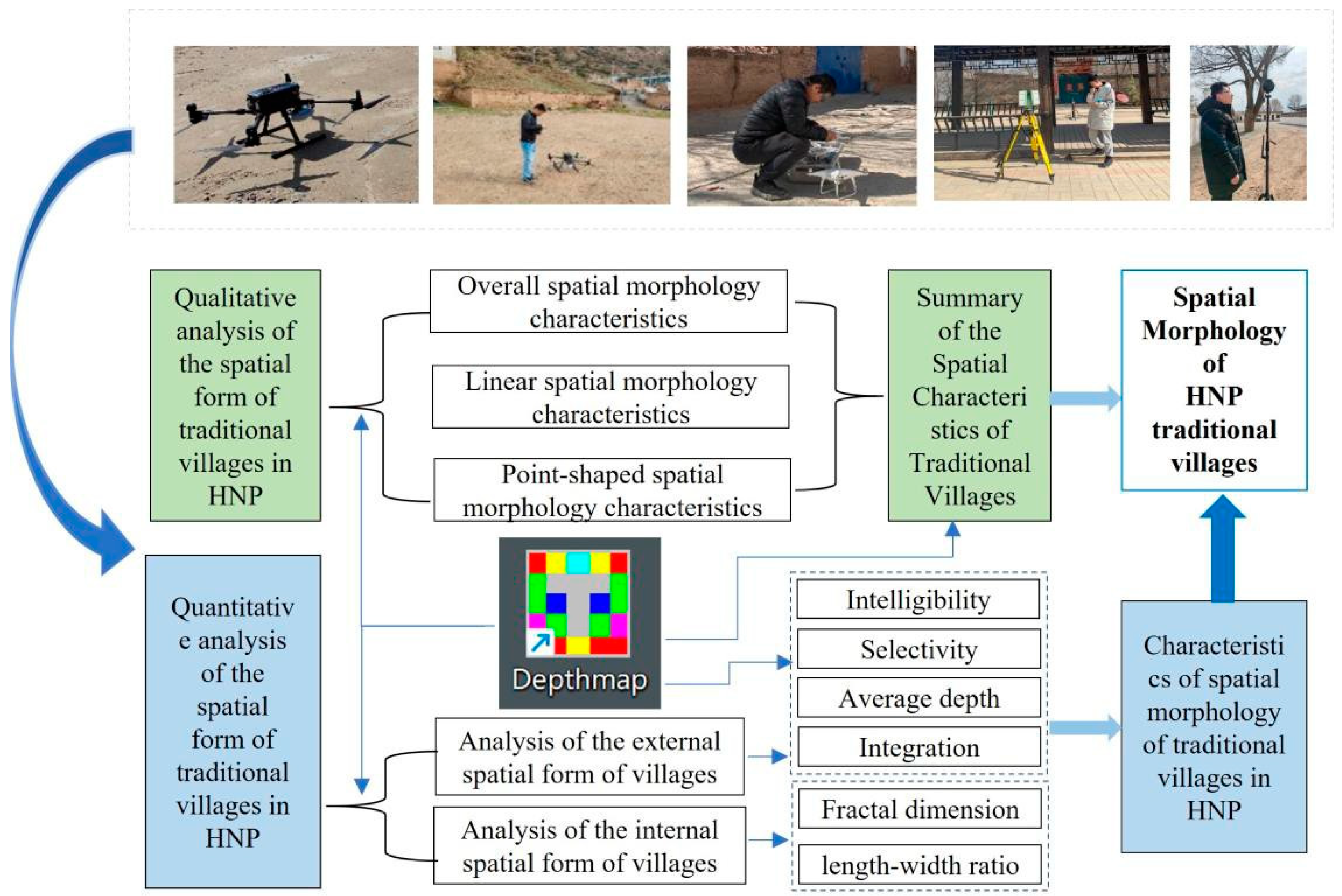
2. Materials and Methods
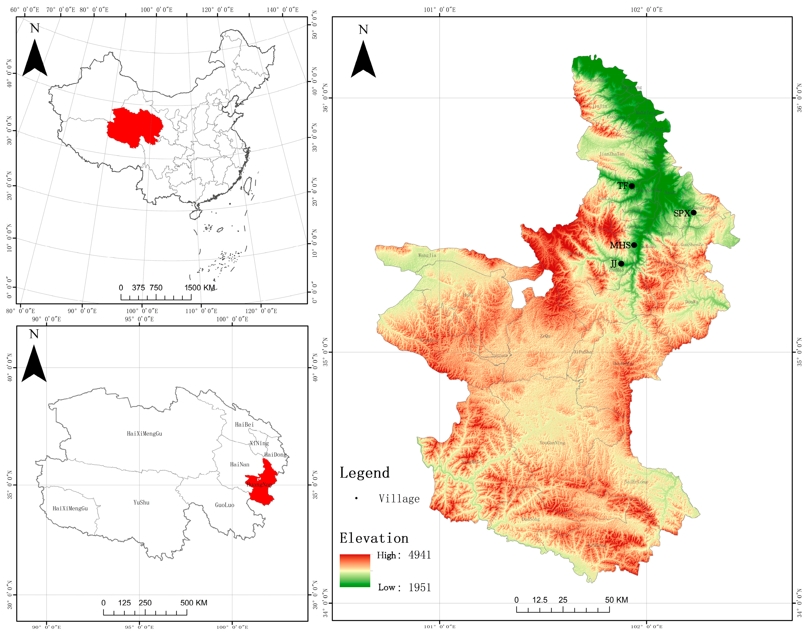
2.1. Study Area
2.2. Data Sources and Processing
2.3. Methods
2.3.1. Fractal Model
2.3.2. Shape Index
2.4. Spatial Syntax Model and Parameter Setting
3. Results
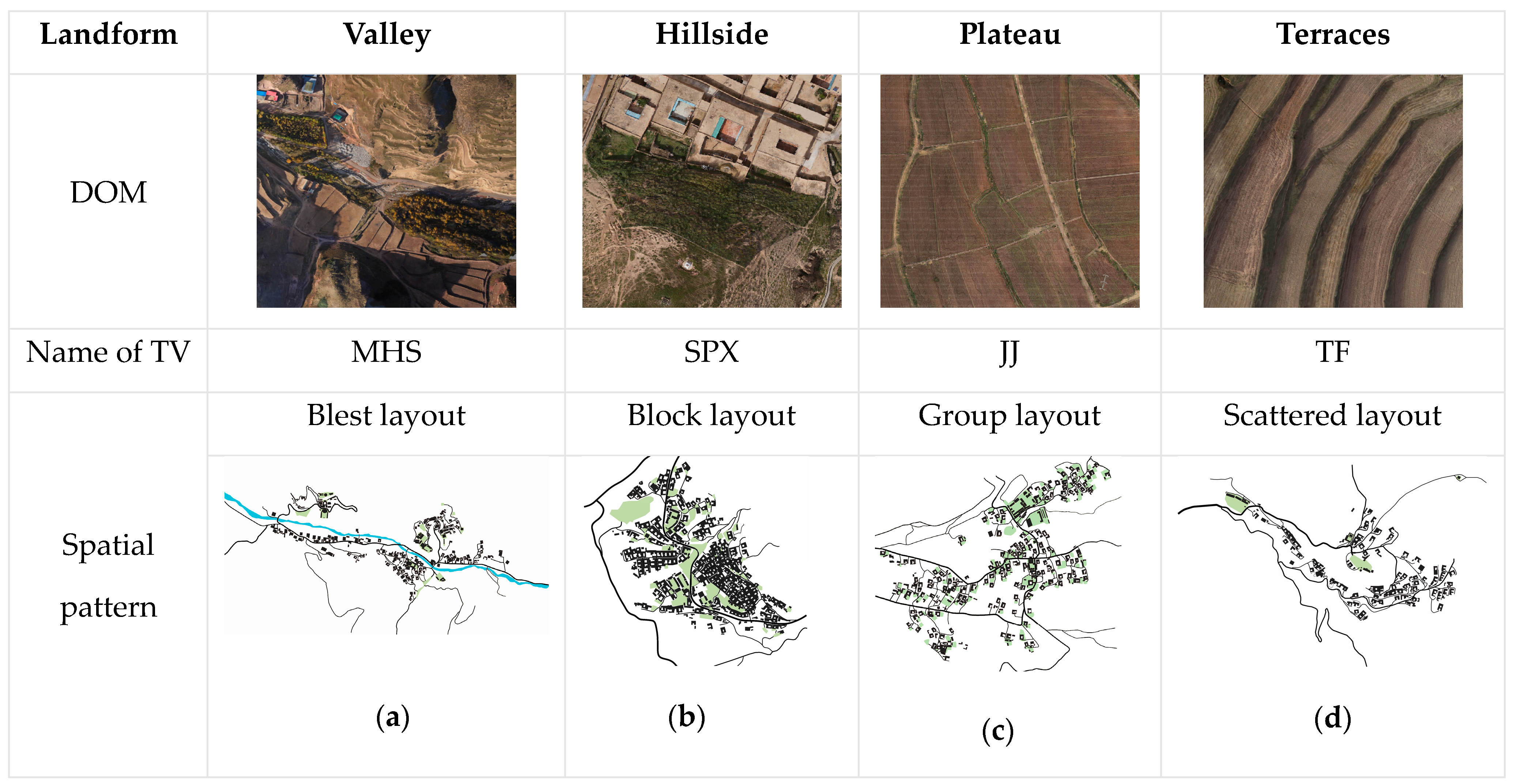
3.1. Qualitative Analysis of the Spatial Morphology of TVs in the HNP
- (1)
- Overall spatial pattern of TVs
- (i)
- Best Layout
- (ii)
- Block Layout
- (iii)
- Group Layout
- (iv)
- Scattered Layout
- (2)
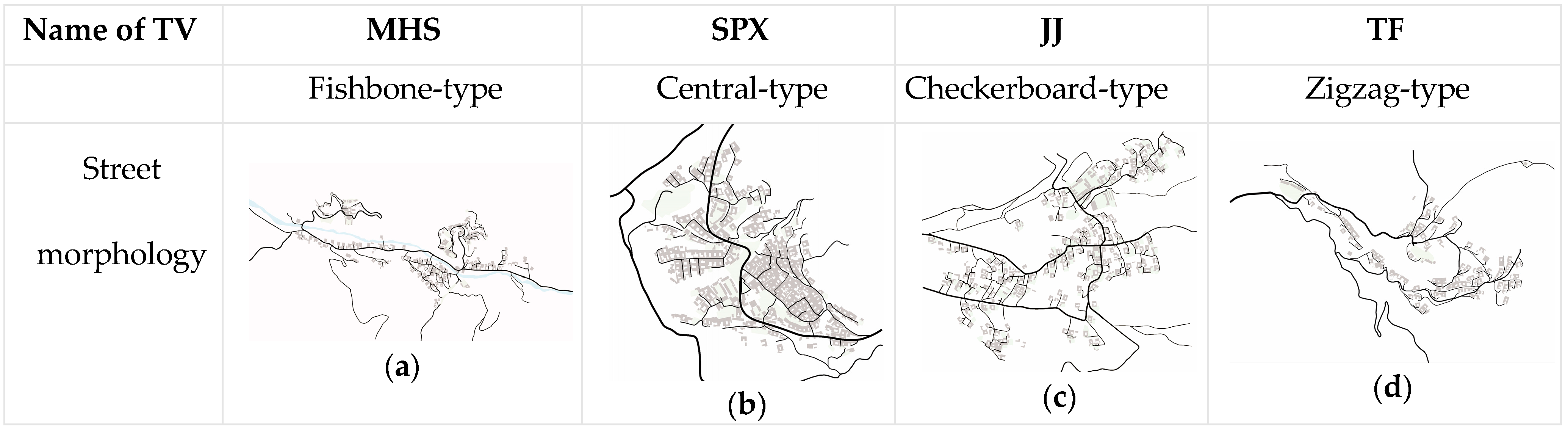
- Linear space of TVs
- (i)
- Fishbone-type streets and alleys
- (ii)
- Central-type streets and alleys
- (iii)
- Checkerboard-type streets and lanes
- (iv)
- Zigzag-type streets
- (3)
- Point-like space of TVs
3.2. Quantitative Analysis of the External Spatial Morphology of TVs in the HNP
3.2.1. Overall Spatial Morphology of TVs
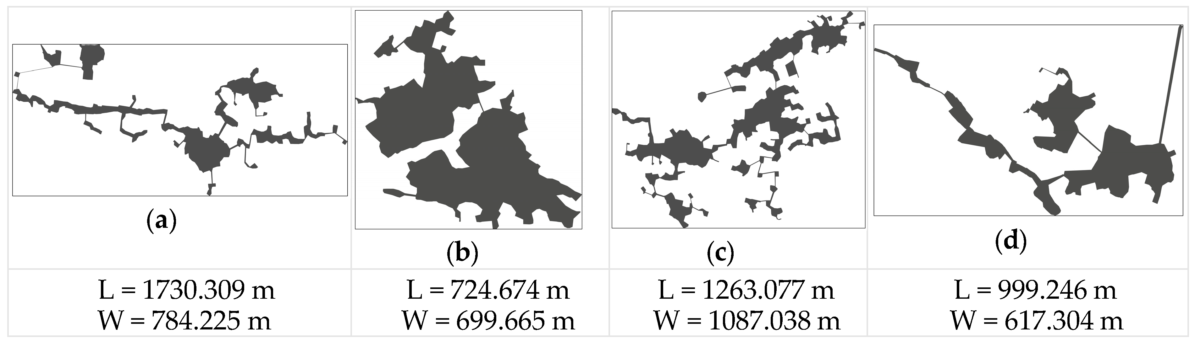
3.2.2. The Boundary Morphology of TVs
3.3. Quantitative Analysis of the Internal Spatial Morphology of TVs in the HNP
3.3.1. Overall Spatial Pattern Analysis
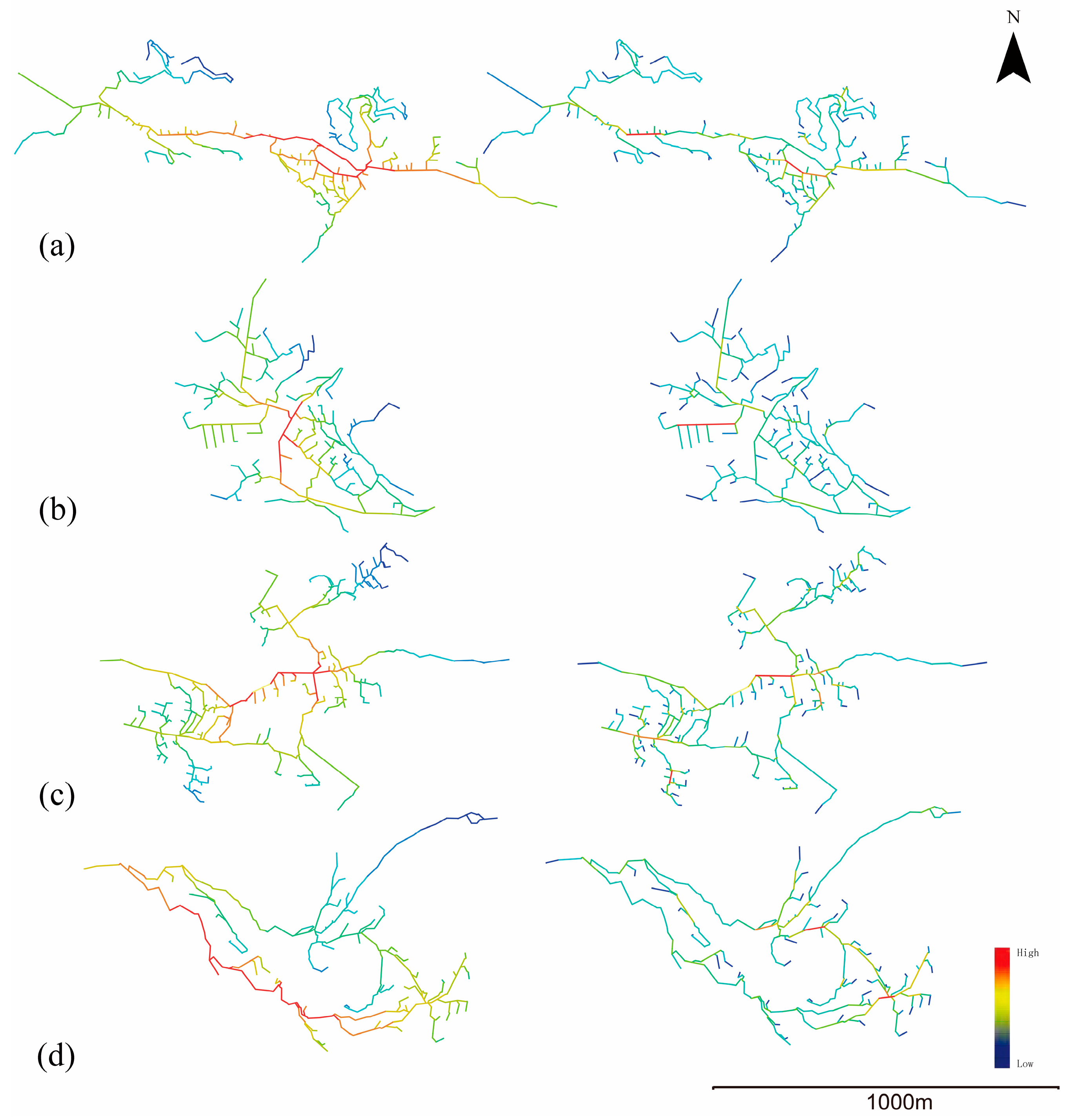
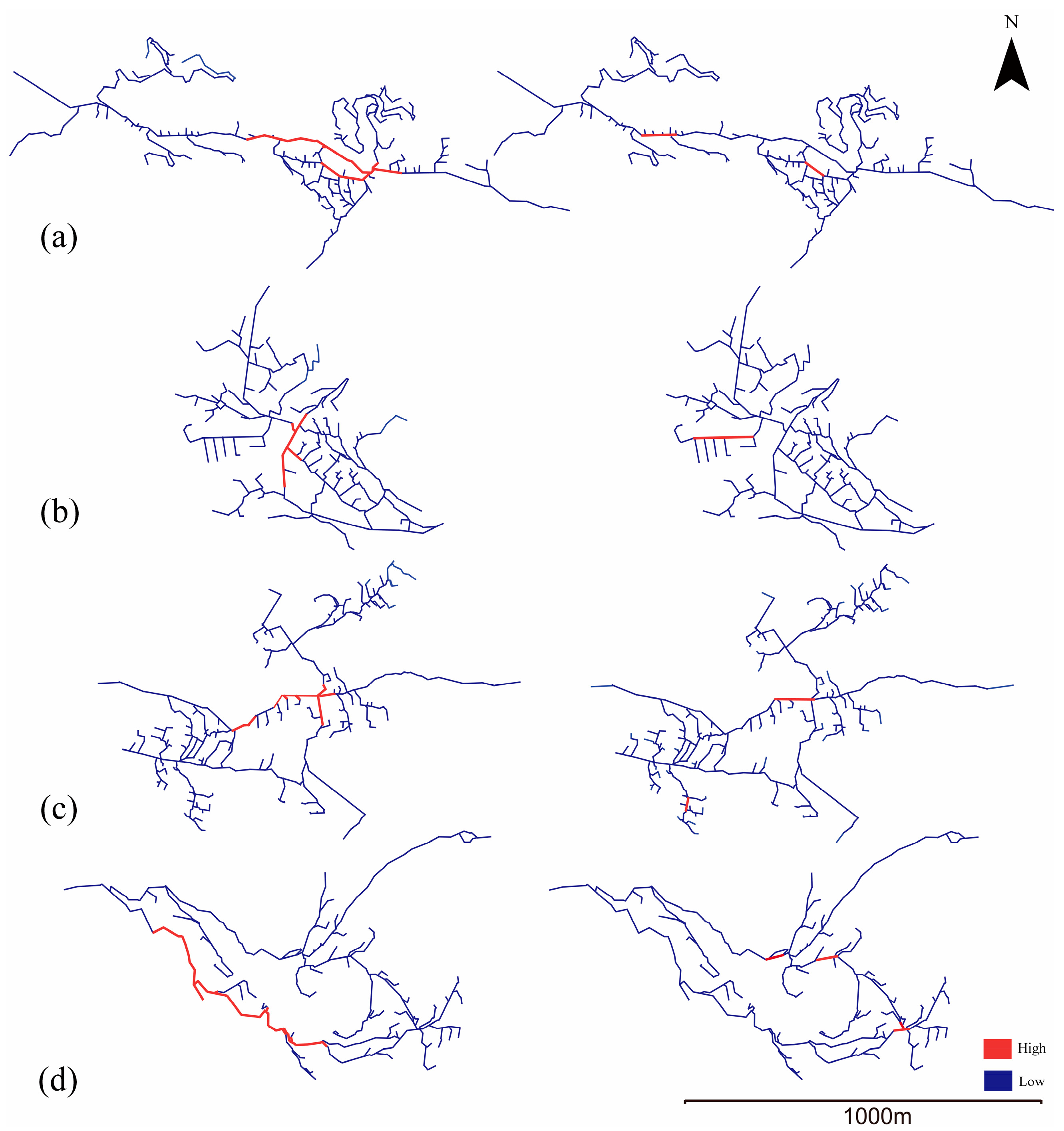
3.3.2. Quantitative Analysis of Street Morphology
- (1)
- Selectivity
- (2)
- Mean depth
- (3)
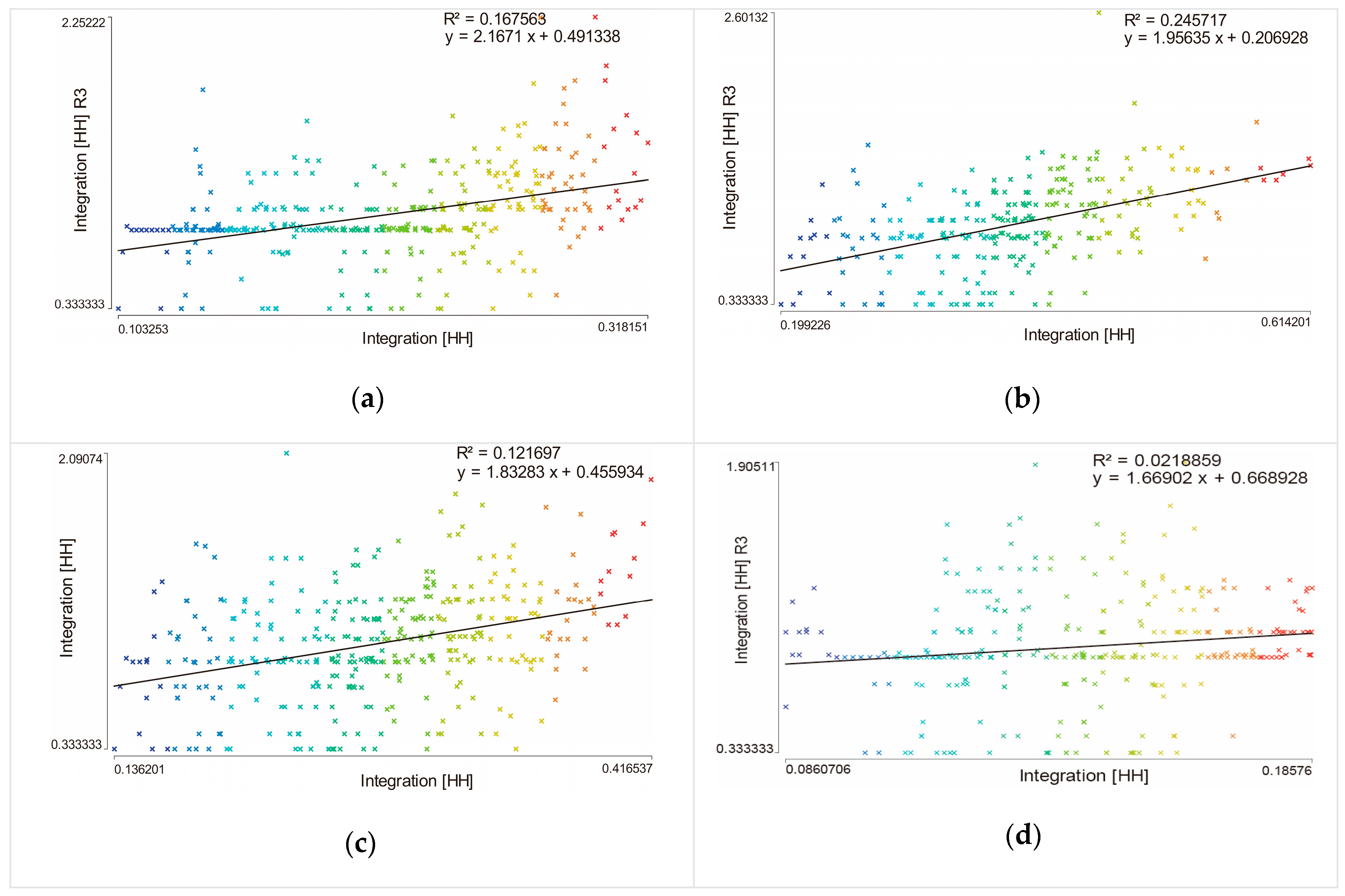
- Integration degree
3.3.3. Quantitative Analysis of Public Space
4. Discussion
4.1. The Comparative Value of the External Spatial Form of the TVs
4.2. The Comparative Value of the Internal Spatial Form of TVs
4.3. The Comparative Value of Public Spaces in TVs
4.4. Limitations of This Study
5. Conclusions
Author Contributions
Funding
Institutional Review Board Statement
Informed Consent Statement
Data Availability Statement
Conflicts of Interest
References
- Kohl, J.G. Der Verkehr und die Ansiedelungen der Menschen in Ihrer Abhängigkeit von der Gestaltung der Erdoberfläche: Mit 24 Steindrucktafeln; HardPress Publishing: Miami, FL, USA, 1841. [Google Scholar]
- Meitzen, A. Siedelung und Agrarwesen der Westgermanen und Ostergemanen: Der Kelten, Römer, Finnen und Slawen; W. Hertz: Berlin, Germany, 1895; Volume 2. [Google Scholar]
- Hoffman, G.W. Transformation of rural settlement in Bulgaria. Geogr. Rev. 1964, 54, 45–64. [Google Scholar] [CrossRef]
- McGrath, B. The sustainability of a car dependent settlement pattern: An evaluation of new rural settlement in Ireland. Environ. Ment. 1998, 19, 99–107. [Google Scholar]
- Pacione, M. Rural Geography; Harper and Row: New York, NY, USA, 1984. [Google Scholar]
- Hill, M.R. Rural Settlement and the Urban Impact on the Countryside; Hodder & Stoughton: London, UK, 2003. [Google Scholar]
- Fu, J.; Zhou, J.L.; Deng, Y.Y. Heritage values of ancient vernacular residences in traditional villages in Western Hunan, China: Spatial patterns and influencing factors. Build. Environ. 2021, 188, 107473. [Google Scholar] [CrossRef]
- Zhai, Z.Y.; Li, T.S.; Chang, F. Research on the Cultural Heritage Landscape Genome Maps of Traditional Villages in Shaanxi Province. Geogr. Geo-Inf. Sci. 2018, 34, 87–94. [Google Scholar]
- Wang, L.; Sun, C.; Wang, M.; Xiao, X. Construction and Characterization of Traditional Village Landscape Cultural Genome Atlases: A Case Study in Xupu County, Hunan, China. Sustainability 2024, 16, 9524. [Google Scholar] [CrossRef]
- Li, R.; Mao, L. Spatial characteristics of suburban villages based on spatial syntax. Sustainability 2022, 14, 14195. [Google Scholar] [CrossRef]
- Nie, Z.; Li, N.; Pan, W.; Yang, Y.; Chen, W.; Hong, C. Quantitative Research on the Form of traditional villages based on the space gene—A case study of Shibadong Village in Western Hunan China. Sustainability 2022, 14, 8965. [Google Scholar] [CrossRef]
- Pei, Y.F.; Gong, K.; Leng, J.W. Study on the inter-village space of a traditional village group in Huizhou Region: Hongguan Village group as an example. Front. Archit. Res. 2020, 9, 588–605. [Google Scholar] [CrossRef]
- Yang, R.; Pan, Y.; Xu, Q. Space diversification process and evolution mechanism of typical village in the suburbs of Guangzhou: A case study of Beicun. J. Geogr. Sci. 2020, 30, 1155–1178. [Google Scholar] [CrossRef]
- Chen, X.; Liu, X.B. Quantitative Analysis of Urban Spatial Morphology Based on GIS Regionalization and Spatial Syntax. J. Indian Soc. Remote Sens. 2023, 51, 1855–1864. [Google Scholar] [CrossRef]
- Fu, X.L. Cognitive research on spatial morphology of traditional villages based on ecological perspective. Fresenius Environ. Bull. 2021, 30, 2285–2289. [Google Scholar]
- Gann, D.W. Spatial Integration: A Space Syntax Analysis of the Villages of the Homol’ovi Cluster; The University of Arizona: Tucson, AZ, USA, 2003. [Google Scholar]
- Du, S. Study on the Tu nationality agricultural traditional village space feature analysis and optimization. J. Environ. Prot. Ecol. 2019, 20, 201–215. [Google Scholar]
- Zhu, Q.; Liu, S. Spatial morphological characteristics and evolution of traditional villages in the mountainous area of Southwest Zhejiang. ISPRS Int. J. Geo-Inf. 2023, 12, 317. [Google Scholar] [CrossRef]
- Chu, K.F.; Wu, M.Y. The traditional settlement planning and the renovation of residential buildings based on spatial syntax analysis. Soft Comput. 2022, 26, 7809–7815. [Google Scholar] [CrossRef]
- Jia, S.Y.; Mohd, H.B.; Zalena, B.A. Spatial characteristics of defensive traditional architecture in multiethnic village of Guangxi: Case studies of Mozhuang Village and Guxietun Village. Front. Archit. Res. 2023, 12, 683–699. [Google Scholar] [CrossRef]
- Huang, Y.; Zhang, Z.; Fei, J.; Chen, X. Optimization strategies of commercial layout of traditional villages based on space syntax and space resistance model: A case study of anhui longchuan village in china. Buildings 2023, 13, 1016. [Google Scholar] [CrossRef]
- Jiang, Y.J.; Li, N.; Wang, Z.Y. Parametric Reconstruction of Traditional Village Morphology Based on the Space Gene Perspective—The Case Study of Xiaoxi Village in Western Hunan, China. Sustainability 2023, 15, 2088. [Google Scholar] [CrossRef]
- Lai, Q.; Liu, W.; Li, X.; Jin, Q. Spatial characteristics and cultural factors of Yi nationality traditional dwellings based on spatial syntax. Front. Earth Sci. 2024, 11, 1330142. [Google Scholar] [CrossRef]
- Wang, H.; Pu, X.; Wang, R.; Zeng, Y.; Qi, X. A study on closed halls in traditional dwellings in the Jiangnan Area, China. J. Asian Archit. Build. Eng. 2016, 15, 139–146. [Google Scholar] [CrossRef]
- Bian, J.J.; Chen, W.X.; Zeng, J. Spatial distribution characteristics and influencing factors of traditional villages in China. Int. J. Environ. Res. Public Health 2022, 19, 2031–2044. [Google Scholar] [CrossRef]
- Liu, W.X.; Xue, Y.; Shang, C. Spatial distribution analysis and driving factors of traditional villages in Henan province: A comprehensive approach via geospatial techniques and statistical models. Herit. Sci. 2023, 11, 185. [Google Scholar] [CrossRef]
- Gul, D.; Rodríguez-Rodríguez, D.; Nate, E.; Auwan, A.; Salib, M.; Lorry, L.; Keven, J.B.; Katusele, M.; Rosado, J.; Hofmann, N.; et al. Investigating differences in village-level heterogeneity of malaria infection and household risk factors in Papua New Guinea. Sci. Rep. 2022, 11, 16540. [Google Scholar] [CrossRef]
- Fan, J.; Zheng, B.; Zhang, B.; Huang, Z.; Liu, J. Research on the revitalization path of ethnic villages based on the inheritance of spatial cultural genes-taking Tujia village of Feng Xiang Xi in Guizhou province as a case study. Sustainability 2023, 15, 1303. [Google Scholar] [CrossRef]
- Fanta, V.; Beneš, J.; Zouhar, J.; Rakava, V.; Šitnerová, I.; Molnárová, K.J.; Šmejda, L.; Sklenicka, P. Ecological and historical factors behind the spatial structure of the historical field patterns in the Czech Republic. Sci. Rep. 2022, 12, 8645. [Google Scholar]
- Lin, Z.R.; Liang, Y.; Liu, X.H. Study on spatial form evolution of traditional villages in Jiuguan under the influence of historic transportation network. Herit. Sci. 2024, 12, 29. [Google Scholar] [CrossRef]
- Afnarius, S.; Syukur, M.; Ekaputra, E.G.; Parawita, Y.; Darman, R. Development of GIS for buildings in the customary village of minangkabau Koto Gadang, West Sumatra, Indonesia. ISPRS Int. J. Geo-Inf. 2020, 9, 365. [Google Scholar] [CrossRef]
- Yamu, C.; Van Nes, A.; Garau, C. Bill Hillier’s Legacy: Space Syntax—A Synopsis of Basic Concepts, Measures, and Empirical Application. Sustainability 2021, 13, 3394. [Google Scholar] [CrossRef]
- Duan, Y.; Yan, L.; Lai, Z.; Chen, Q.; Sun, Y.; Zhang, L. The spatial form of traditional villages in Fuzhou area of Jiangxi Province determined via GIS methods. Front. Earth Sci. 2022. [Google Scholar] [CrossRef]
- Liu, J.; Song, Q.; Wang, X. Spatial morphology evolution of rural settlements in the lower yellow river plain: The case of Menggang town in Changyuan City, China. Land 2023, 12, 1122. [Google Scholar] [CrossRef]
- Xie, N.L.; Cheng, B. The Impact of Urban Expressways on the Street Space of Traditional Tibetan Villages in Kham, Taking Daofu County as an Example. Sustainability 2023, 15, 3513. [Google Scholar] [CrossRef]
- Zhang, D.; Shi, Z.X.; Cheng, M.Y. A Study on the Spatial Pattern of Traditional Villages from the Perspective of Courtyard House Distribution. Buildings 2023, 13, 1913. [Google Scholar] [CrossRef]
- Cheng, G.; Li, Z.; Xia, S.; Gao, M.; Ye, M.; Shi, T. Research on the Spatial Sequence of Building Facades in Huizhou Regional Traditional Villages. Buildings 2023, 13, 174. [Google Scholar] [CrossRef]
- Peng, Y.; Qiu, H.; Wang, X.L. The Influence of Spatial Functions on the Public Space System of Traditional Settlements. Sustainability 2023, 15, 8632. [Google Scholar] [CrossRef]
- Tao, J.; Chen, H.; Zhang, S.; Xiao, D. Space and Culture: Isomerism in Vernacular Dwellings in Meizhou, Guangdong Province, China. J. Asian Archit. Build. Eng. 2018, 17, 15–22. [Google Scholar] [CrossRef]
- Zhou, Z.; Jia, Z.; Wang, N.; Fang, M. Sustainable Mountain Village Construction Adapted to Livelihood, Topography, and Hydrology: A Case of Dong Villages in Southeast Guizhou, China. Sustainability 2019, 10, 4619. [Google Scholar] [CrossRef]
- Zhang, D.; Shi, C.H.; Li, L.R. Study of the differences in the space order of traditional rural settlements. J. Asian Archit. Build. Eng. 2023, 22, 461–475. [Google Scholar] [CrossRef]
- Hong, C.L.; Qian, Q.M. Comparative study of campus spatial morphology based on spatial syntax—Take the Jinming campus and Minglun Campus of Henan University as an example. Reg. Res 2021, 40, 63–68. [Google Scholar]
- Pu, X.C.; Wang, Z.; Huang, Q. Analysis On The Boundary Pattern Of The Rural Settlement. Archit. Cult. 2013, 8, 48–49. [Google Scholar]
- Hillier, B.; Hanson, J. The Social Logic of Space; Cambridge University Press: Cambridge, UK, 1984. [Google Scholar]
- Xu, Y.B.; Rollo, J.; Esteban, Y. Evaluating Experiential Qualities of Historical Streets in Nanxun Canal Town through a Space Syntax Approach. Buildings 2021, 11, 544. [Google Scholar] [CrossRef]
- Li, W.; Chen, M.; Yao, N.; Luo, Z.; Jiao, Y. Spatial-temporal evolution of roadway layout system from a space syntax perspective. Tunn. Undergr. Space Technol. 2023, 135, 105038. [Google Scholar] [CrossRef]
- Kamelnia, H.; Hanachi, P.; Moayedi, M. Exploring the spatial structure of Toon historical town courtyard houses: Topological characteristics of the courtyard based on a configuration approach. J. Cult. Heritage Manag. Sustain. Dev. 2022, 14, 981–997. [Google Scholar] [CrossRef]
- Gong, L.; Yang, J.; Wu, C.; Zhou, H. Fractal Characteristics of the Spatial Texture in Traditional Miao Villages in Qiandongnan, Guizhou, China. Sustainability 2023, 15, 13218. [Google Scholar] [CrossRef]
- Rao, X.; Zhou, J.; Ding, K.; Wang, J.; Fu, J.; Zhu, Q. Research on the Cultural Tracing of the Patriarchal Clan System of Traditional Buildings in the Eastern Zhejiang Province, China, Based on Space Syntax: The Case Study of Huzhai in Shaoxing. Sustainability 2022, 14, 7247. [Google Scholar] [CrossRef]
- Zhu, X.G.; Li, T.; Feng, T.T. On the Synergy in the Sustainable Development of Cultural Landscape in Traditional Villages under the Measure of Balanced Development Index: Case Study of the Zhejiang Province. Sustainability 2022, 14, 11367. [Google Scholar] [CrossRef]
- Huynh, H.N. Spatial point pattern and urban morphology: Perspectives from entropy, complexity and networks. Phys. Rev. E 2019, 100, 210–224. [Google Scholar] [CrossRef]
- Ma, H.D.; Tong, Y.Q. Spatial differentiation of traditional villages using ArcGIS and GeoDa: A case study of Southwest China. Ecol. Inform. 2022, 68, 101416. [Google Scholar] [CrossRef]
- Wang, D.; Zhu, Y.; Zhao, M.; Lv, Q. Multi-dimensional hollowing characteristics of traditional villages and its influence mechanism based on the micro-scale: A case study of Dongcun Village in Suzhou, China. Land Use Policy 2021, 101, 105146. [Google Scholar] [CrossRef]
- Xi, J.; Wang, X.; Kong, Q.; Zhang, N. Spatial morphology evolution of rural settlements induced by tourism: A comparative study of three villages in Yesanpo tourism area, China. Acta Geogr. Sin. 2014, 69, 531–540. [Google Scholar] [CrossRef]


| λ Worth | Morphological Types | S Worth | λ Worth | Segmentation by Type |
|---|---|---|---|---|
| λ ≥ 2 | Fingerprint | S ≥ 2 | λ < 1.5 | Fingerprints with doughnut tendencies |
| 1.5 ≤ λ < 2 | Indications of no clear preference | |||
| 1.5 ≤ λ < 2 | No clear direction | λ ≥ 2 | Fingerprints with a tendency of banding | |
| S ≤ 2 | λ < 1.5 | Globular | ||
| λ < 1.5 | Globular | 1.5 ≤ λ < 2 | Clusters with banding tendencies | |
| λ ≥ 2 | Ribbon |
| Village Name | Area of Public Space A (m2) | Perimeter of Public Space P (m) | Sub Dimensional Value D | Histomorphic Type |
|---|---|---|---|---|
| MHS | 119,976.904 | 27,385.158 | 1.5103 | Strongly Structured |
| SPX | 113,988.59 | 26,209.8285 | 1.5094 | Strongly Structured |
| JJ | 165,099.494 | 37,975.2952 | 1.5246 | Strongly Structured |
| TF | 82,497.0098 | 14,375.7026 | 1.4464 | Medium Structured |
| Name of TV | Area of Public Space A (m2) | Perimeter of Public Space P (m) | Sub-Dimensional Value D | Histomorphic Type |
|---|---|---|---|---|
| MHS | 119,976.904 | 27,385.158 | 1.5103 | Strongly structured |
| SPX | 113,988.590 | 26,209.829 | 1.5094 | Strongly structured |
| JJ | 165,099.494 | 37,975.295 | 1.5246 | Strongly structured |
| TF | 82,497.009 | 14,375.703 | 1.4464 | Medium structured colonies |
| Name | Integration [HH] R3 | Integration [HH] | Scatter Plot Correlation Coefficient | Comprehensibility |
|---|---|---|---|---|
| MHS | 0.956 | 0.214 | 2.167 | 0.167 |
| SPX | 0.957 | 0.384 | 1.956 | 0.246 |
| JJ | 0.959 | 0.275 | 1.833 | 0.122 |
| TF | 0.907 | 0.142 | 1.669 | 0.022 |
| Name of TV | Choice | Average Depth | Degree of Integration | ||||
|---|---|---|---|---|---|---|---|
| Minimum | Average | Maximum | Mean Depth | Mean Depth R3 | Integration [HH] (Average) | Integration [HH] R3 (Average) | |
| MHS | 0 | 0.153 | 1.068 | 31.608 | 2.108 | 0.214 | 0.956 |
| SPX | 0 | 0.109 | 1.094 | 16.341 | 2.128 | 0.384 | 0.957 |
| JJ | 0 | 0.12 | 1.265 | 24.319 | 2.135 | 0.275 | 0.959 |
| TF | 0 | 0.271 | 1.066 | 42.552 | 2.087 | 0.142 | 0.907 |
| Name of TVs | Global Integration (I) | R3 Local Integration (I) | ||||
|---|---|---|---|---|---|---|
| Average | Minimum | Maximum | Average | Minimum | Maximum | |
| MHS | 0.214 | 0.103 | 0.318 | 0.956 | 0.333 | 2.252 |
| SPX | 0.384 | 0.199 | 0.614 | 0.957 | 0.333 | 2.601 |
| JJ | 0.275 | 0.316 | 0.417 | 0.959 | 0.333 | 2.901 |
| TF | 0.142 | 0.086 | 0.186 | 0.907 | 0.333 | 1.905 |
Disclaimer/Publisher’s Note: The statements, opinions and data contained in all publications are solely those of the individual author(s) and contributor(s) and not of MDPI and/or the editor(s). MDPI and/or the editor(s) disclaim responsibility for any injury to people or property resulting from any ideas, methods, instructions or products referred to in the content. |
© 2025 by the authors. Licensee MDPI, Basel, Switzerland. This article is an open access article distributed under the terms and conditions of the Creative Commons Attribution (CC BY) license (https://creativecommons.org/licenses/by/4.0/).
Share and Cite
Feng, X.; Hu, M.; Somenahalli, S.; Zhang, W.; Liu, K.; Li, M.; Zhou, Z.; Li, F. Study on the Spatial Morphology of Ando Tibetan Traditional Villages in China: A Case of Traditional Villages in Huangnan Prefecture. Sustainability 2025, 17, 1353. https://doi.org/10.3390/su17041353
Feng X, Hu M, Somenahalli S, Zhang W, Liu K, Li M, Zhou Z, Li F. Study on the Spatial Morphology of Ando Tibetan Traditional Villages in China: A Case of Traditional Villages in Huangnan Prefecture. Sustainability. 2025; 17(4):1353. https://doi.org/10.3390/su17041353
Chicago/Turabian StyleFeng, Xiaogang, Moqing Hu, Sekhar Somenahalli, Wenbin Zhang, Kunyan Liu, Meng Li, Zaihui Zhou, and Fengxia Li. 2025. "Study on the Spatial Morphology of Ando Tibetan Traditional Villages in China: A Case of Traditional Villages in Huangnan Prefecture" Sustainability 17, no. 4: 1353. https://doi.org/10.3390/su17041353
APA StyleFeng, X., Hu, M., Somenahalli, S., Zhang, W., Liu, K., Li, M., Zhou, Z., & Li, F. (2025). Study on the Spatial Morphology of Ando Tibetan Traditional Villages in China: A Case of Traditional Villages in Huangnan Prefecture. Sustainability, 17(4), 1353. https://doi.org/10.3390/su17041353