Urban Afforestation as Spatial Strategy: Applied Design Research on the Eastern Greenway in Rome
Abstract
1. Introduction
2. Background and Theoretical Framework
- Studies based on statistical and quantifiable scientific parameters. This group includes studies based on environmental metrics (such as CO2 sequestration, surface temperature, and biodiversity levels); climatic and GIS-based modelling; quantitative indicators of tree canopy cover. It represents the dominant line of research derived from urban ecology and urban climate science [23,24,25];
- Research in the humanities and social sciences, focusing on cultural, spatial, and social dimensions. This group includes studies that examine: the perception of green spaces; environmental justice and access to urban green; the cultural meanings of landscape; everyday practices of public space. This research tradition is well established in urban geography, landscape studies, and urban sociology [26,27,28];
- Hybrid approaches that integrate quantitative analysis with spatial and design-oriented interpretation. This category is now well recognized in recent literature on: Nature-Based Solutions, Landscape Urbanism, Ecological Urbanism. These studies interweave scientific data with design processes, scenario-building, and spatial transformation strategies [29,30,31].
3. Materials and Methods
3.1. Research Context
3.2. Territorial Scope
3.3. Research Objectives
- Identify the main urban afforestation programs implemented in Lazio and in the metropolitan area of Rome and analyze their benefits and limitations;
- Select national and international case studies exemplifying integrated afforestation approaches;
- Identify priority areas in eastern Rome for increasing natural capital and ecological connectivity;
- Develop a “research by design” case study for the Serenissima Park, including:analysis of spatial potentials and criticalities;
- Identification of areas suitable for afforestation;
- Definition of design goals and spatial strategies;
- Assess the coherence between forestry objectives and ecological, historical, morphological, and social conditions;
- Investigate the principles for a new eastern metropolitan greenway extending from Rome to Tivoli.
3.4. Sources and Materials
- National and international literature on urban afforestation and green infrastructure;
- Institutional and regulatory frameworks (e.g., DL 111/2019; NRRP Mission 2; FAO and European Commission guidance);
- Climate, land-use, and ecological datasets from the Lazio Region, the Metropolitan City of Rome, and ISPRA;
- Quantitative data from local afforestation programs (Ossigeno, Forest for Rome, Riforestiamo Roma);
- Existing cartography, orthophotos, historical maps, and community-generated spatial documents;
- Direct field observations and photographic surveys, particularly in the Serenissima Park area.
3.5. Methodology
- Comparative Analysis of Afforestation Programs.
- 2.
- Selection and Analysis of Exemplary Case Studies.
- 3.
- Identification and Classification of Green Areas in Eastern Rome.
- 4.
- Design Scenarios for the Serenissima Park.
3.6. Research-by-Design Operationalization
- Inputs.
- 2.
- Analytical tools.
- 3.
- Design.
- 4.
- Link between findings and spatial strategies.
4. Results
4.1. A Predominantly Quantitative View of Afforestation
- The Ossigeno program delivered over 440 planting interventions (≈180 in Rome), mostly on small or marginal public plots (school grounds, minor parks, institutional parcels), with an average of 10–15 trees per site. These data indicate a prevalence of small-scale and dispersed interventions. The result is a mosaic of micro-interventions with limited structural or territorial impact [18].
- Forest for Rome (2022) introduced micro-forests to address CO2 sequestration and urban heat-island effects; however, interventions, to date have mainly consisted of punctual plantings with no overarching ecological or spatial network vision [32].
- Riforestiamo Roma focuses mainly on tree replacement, maintenance, and renewal operations rather than territorial-scale afforestation (≈9500 trees in 2024, many linked to Jubilee-related works), this confirms the program’s emphasis on renewal and management operations rather than extensive new afforestation [33].
4.2. Fragmentation and Limited Intervention Scale
4.3. Potentials and Limits of the Regulatory Framework
4.4. Summary of Results
- Quantitatively, data from regional and municipal initiatives indicate that each intervention involves, on average, the planting of 12 trees, corresponding to an estimated annual CO2 absorption of approximately 500 kg per site. Across the Lazio region, this results in a total of roughly 15,000 newly planted trees and about 625,000 kg of CO2 absorbed per year.
- Spatially, GIS analysis reveals that interventions are predominantly micro-scaled and spatially isolated, with most patches below 1 ha and rarely integrated into ecological or public accessibility networks. These patterns reflect the prevailing distribution and location of planting sites selected within the current programs.
- Most interventions appear punctual and dispersed within the regional and municipal territory;
- Quantitative parameters remain the primary criteria guiding the implementation of recent afforestation programs;
- Urban edge areas—particularly in eastern Rome—represent strategic opportunities to reconnect natural systems, residual landscapes, infrastructures, and cultural assets;
- Emerging tools such as Greenspaces and regional digital twins can enable shared, evidence-based monitoring and governance;
- Integrated approaches linking ecological, spatial, and social dimensions can support the development of more continuous green infrastructures.
5. Discussion
5.1. From Quantity to Quality: Toward a New Culture of Urban Green
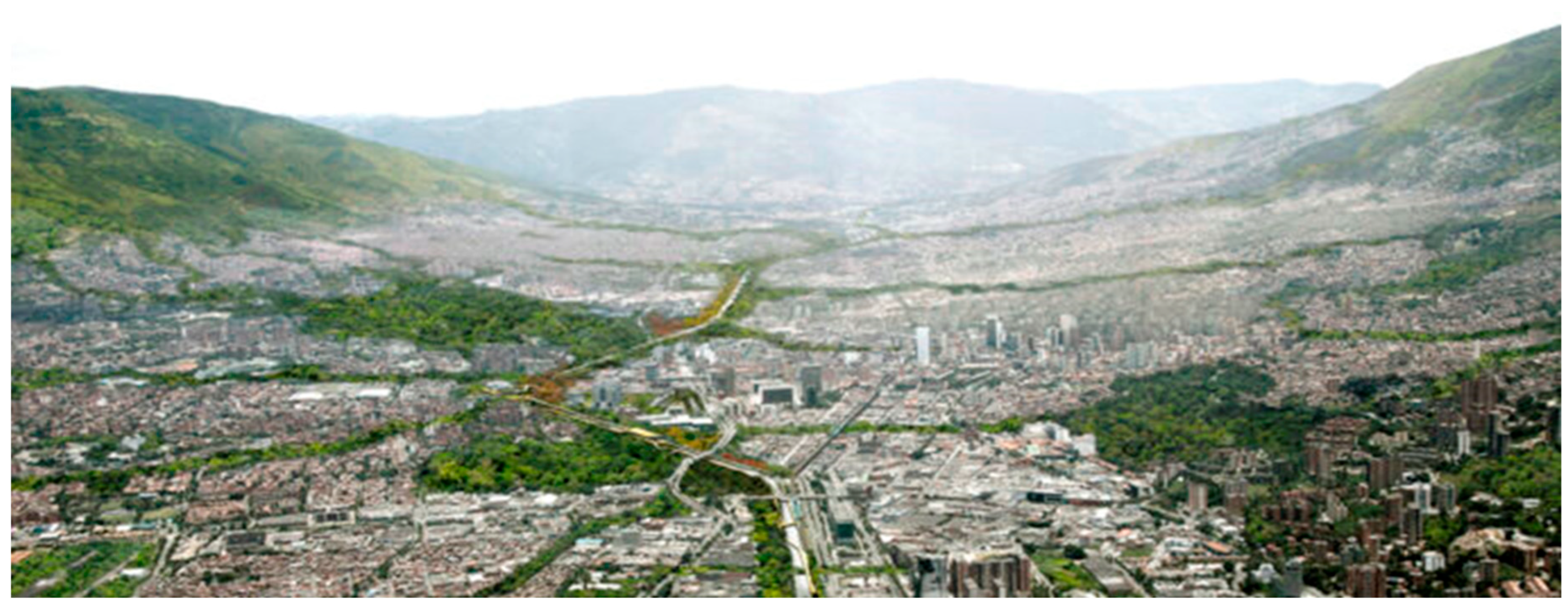
5.2. Medellín: Green Corridors as Climate Infrastructure
- Microclimate regulation: dense multilayered vegetation was used to reduce radiant temperature and cool exposed asphalt and concrete surfaces, producing a measured drop of approximately 2 °C in corridor areas;
- Ecological connectivity: native species and stratified planting supported pollinators and seed dispersal, improving urban biodiversity and reconnecting fragmented habitats;
- Social and mobility integration: the corridors run along bus lines, bike lanes, and pedestrian networks, leading to a 34% increase in cycling and new opportunities for public interaction in formerly inhospitable spaces.
- A network-based strategy, rather than isolated planting;
- Design integration across ecology, mobility, and public space;
- Continuous maintenance and local stewardship as structural components of the project;
- The use of vegetation as urban infrastructure, not decorative planting.
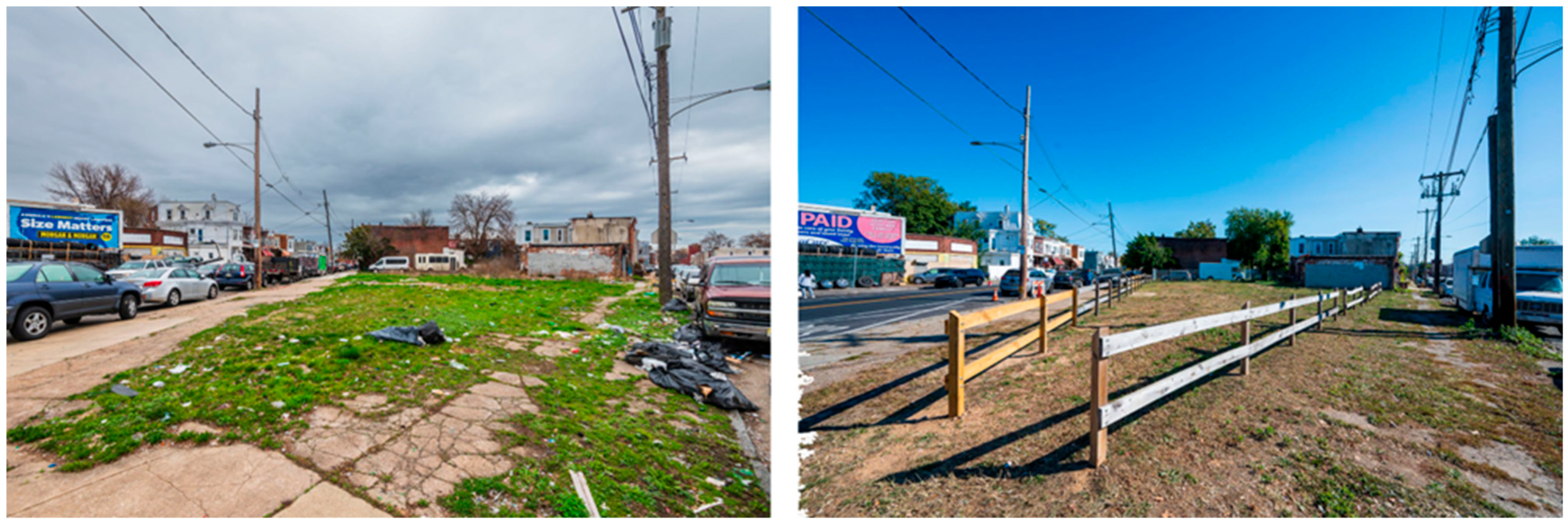
5.3. Philadelphia: Afforestation as Environmental Justice
- Canopy restoration and expansion, with the principle of right tree, right place, selecting species adapted to microclimatic and soil conditions;
- Distributed small-scale greening, integrating trees, rain gardens, and pocket parks into sidewalks, vacant parcels, transit corridors, and schoolyards;
- Community stewardship networks, where planting and maintenance agreements are co-developed with residents, local associations, and schools;
- Incremental implementation, allowing the canopy to grow as community support strengthens and maintenance capacity stabilizes over time.
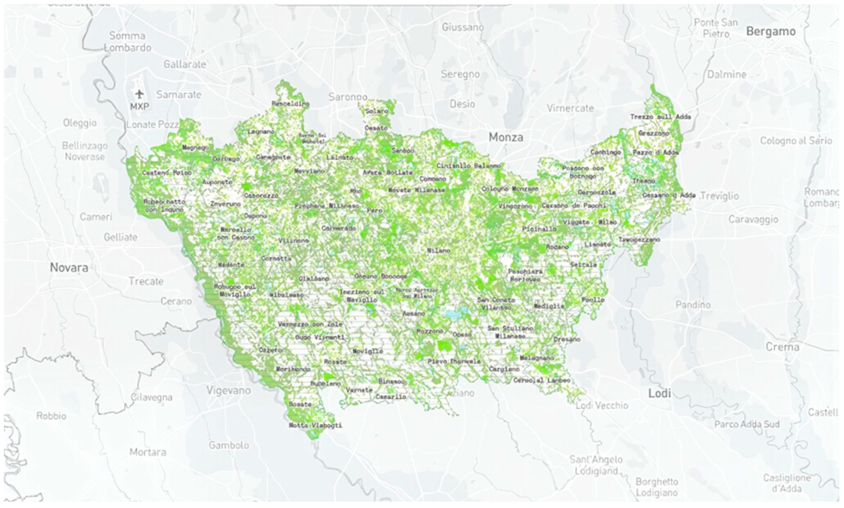
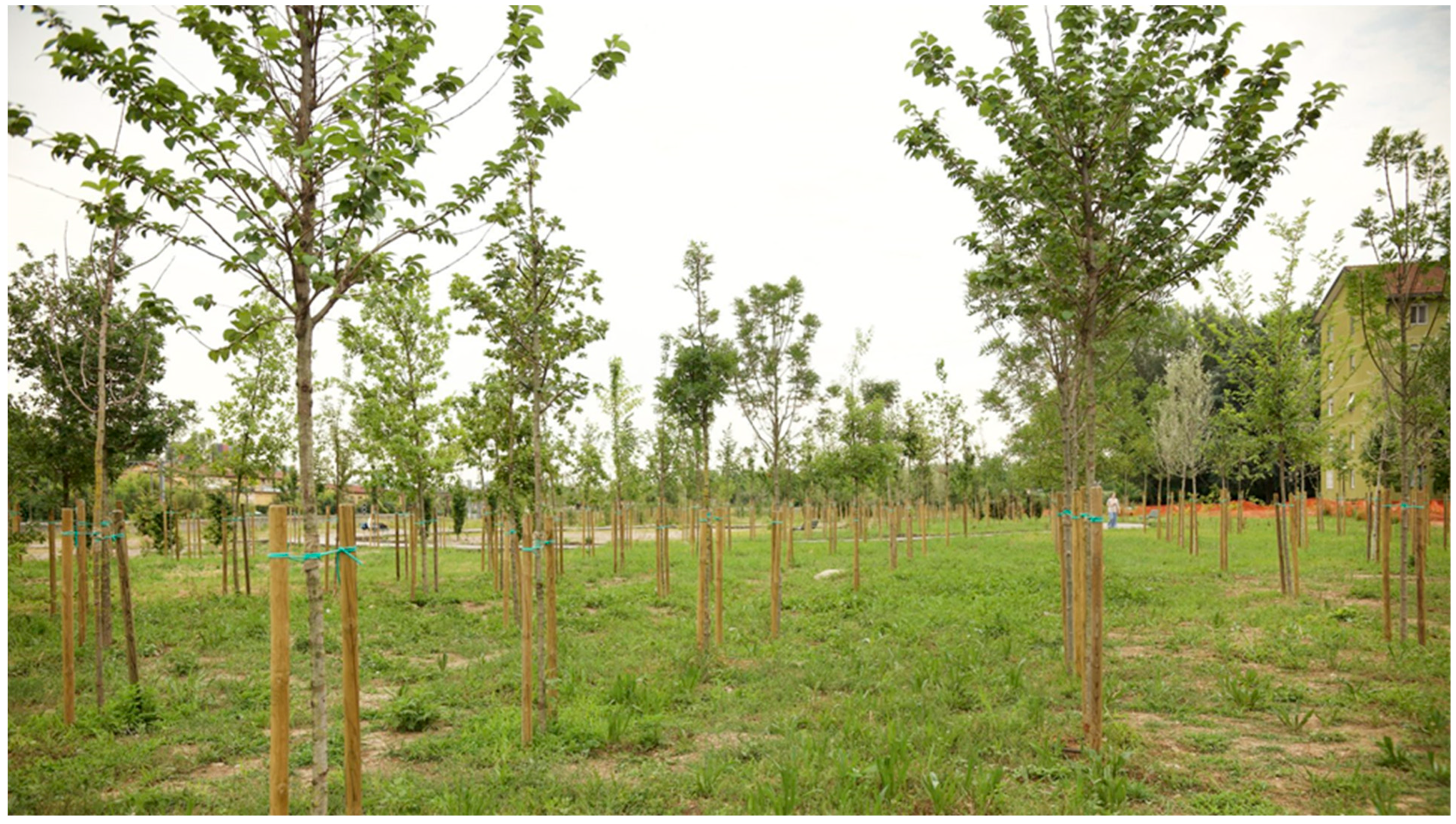
5.4. Milan: An Integrated Governance and Design Model
- Peri-urban agricultural landscapes (Parco Agricolo Sud, Parco Nord, Groane) with urban parks and neighborhood open spaces;
- Identifying strategic ecological corridors along railway lines, former industrial sites, waterways, and infrastructural buffers;
- Prioritizing planting in areas with heat-island stress, soil degradation, or low canopy coverage.
- A georeferenced mapping system of existing vegetation and available planting surfaces;
- Real-time monitoring tools that track canopy growth, survival rates, and ecosystem services;
- A public database enabling transparency and shared stewardship.
- Strategic ecological planning at metropolitan scale;
- Integrated governance and institutional coordination;
- Design-led spatial continuity rather than isolated plantations;
- Transparent monitoring and civic participation.
5.5. Summary and Comparative Analysis
5.6. Toward a Systemic Model for Rome
- Ecological Connectivity
- 2.
- Infrastructural Integration
- 3.
- Design-Led Spatial Quality
- 4.
- Social Engagement and Stewardship
6. Serenissima Park: Research-by-Design Outcomes
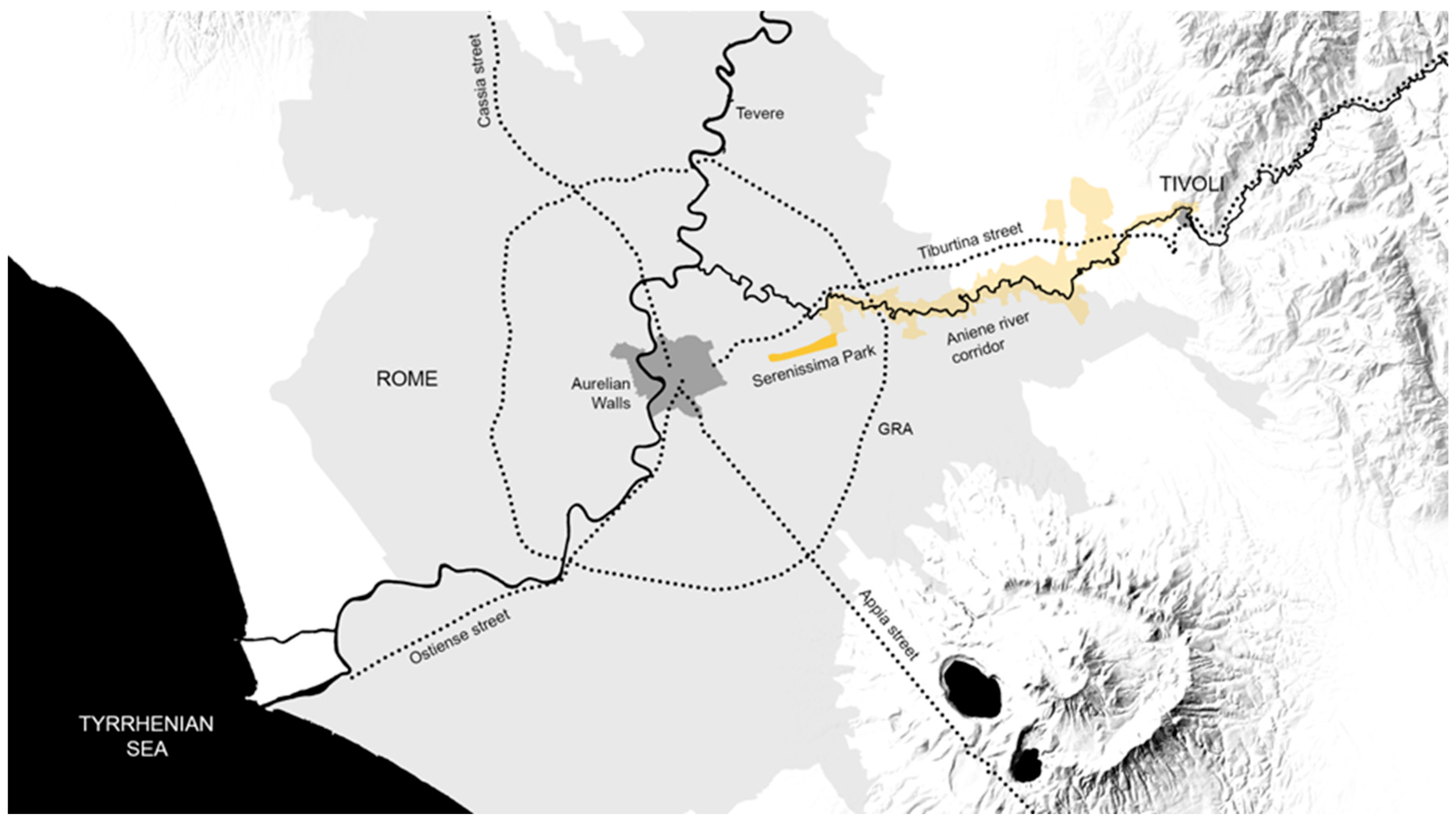
6.1. A Strategic Edge Context
6.2. Design Intent
- High ecological permeability due to non-built surfaces;
- Proximity to major parks (Aguzzano, Aniene Reserve, Centocelle);
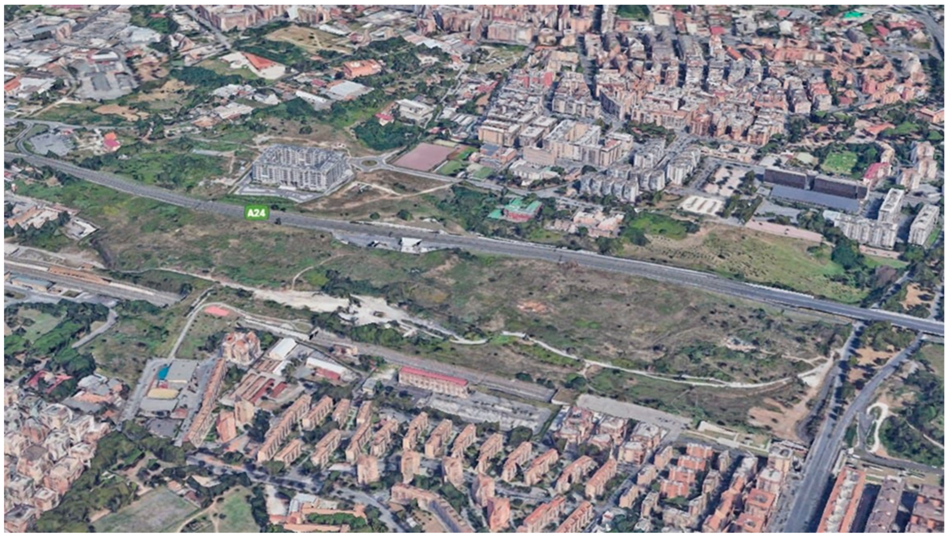
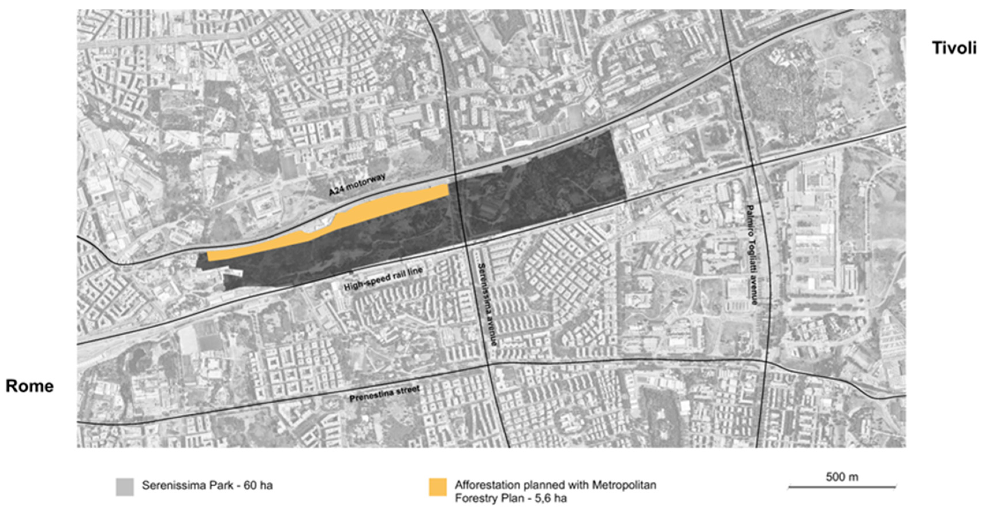
- Potential for a continuous linear green system along main infrastructures, reconnecting isolated fragments.
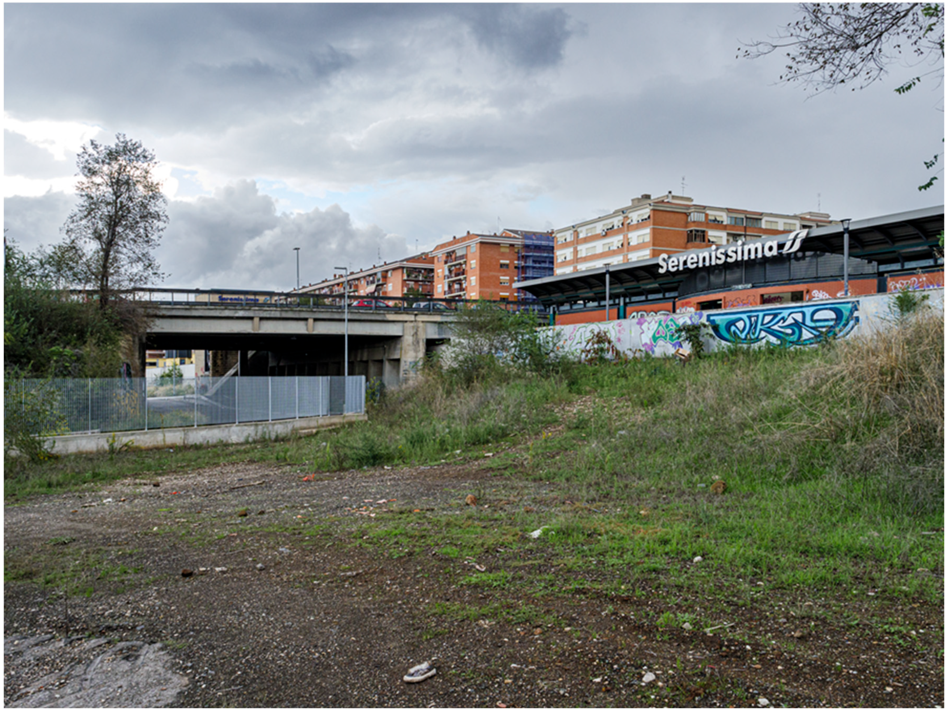
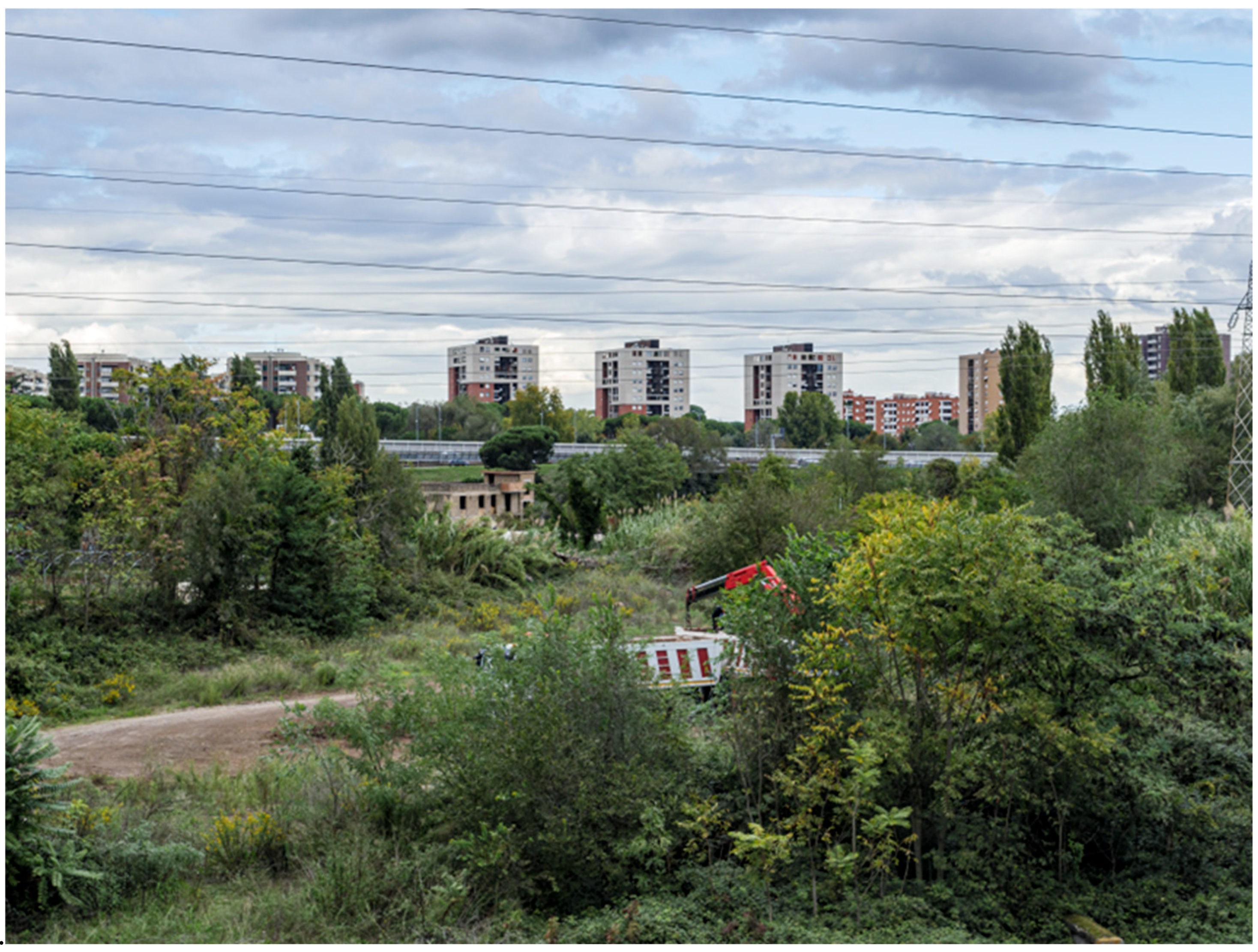
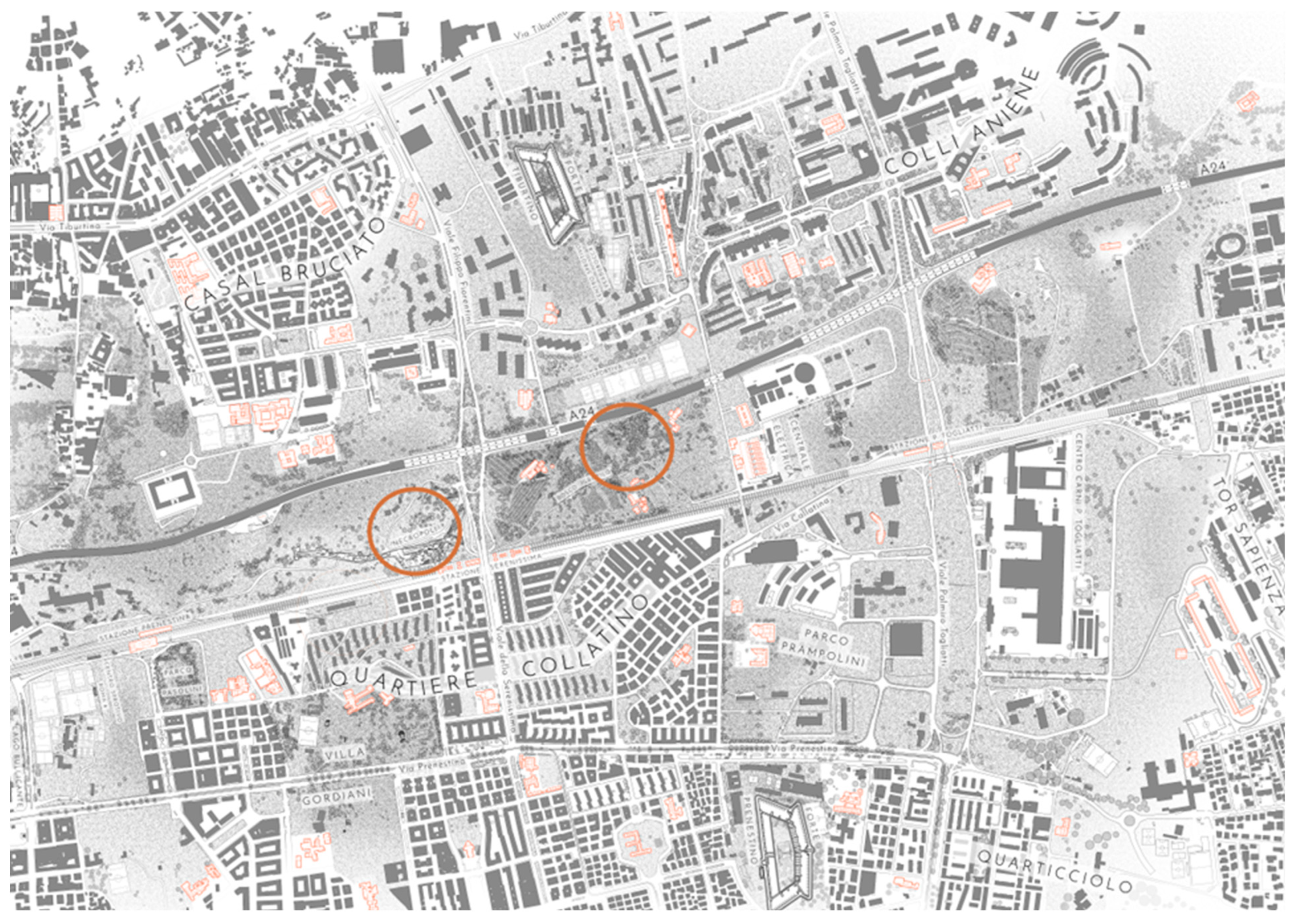
- Opportunity to create transversal links with adjacent neighborhoods currently severed by the A24 and HSR;
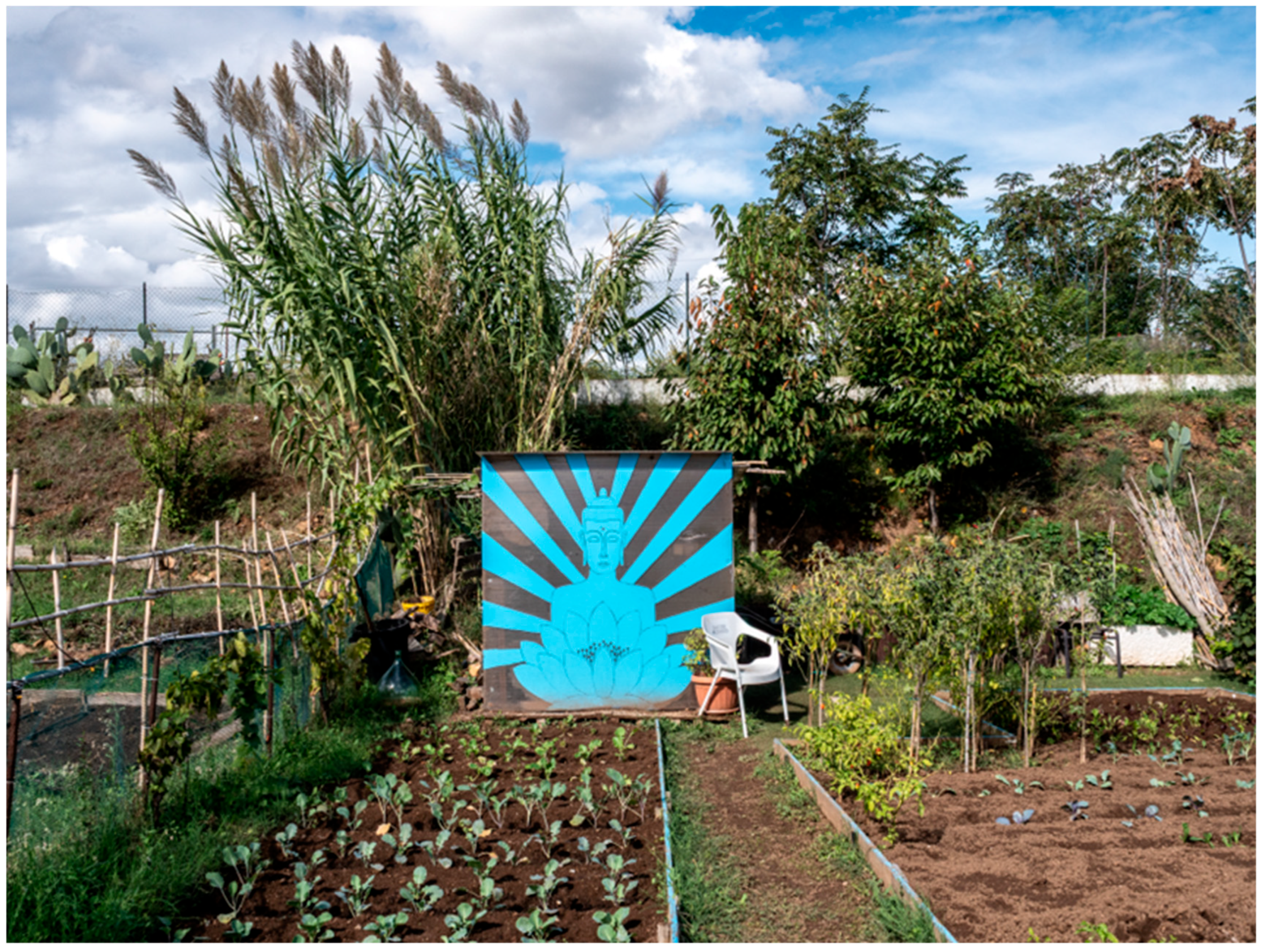
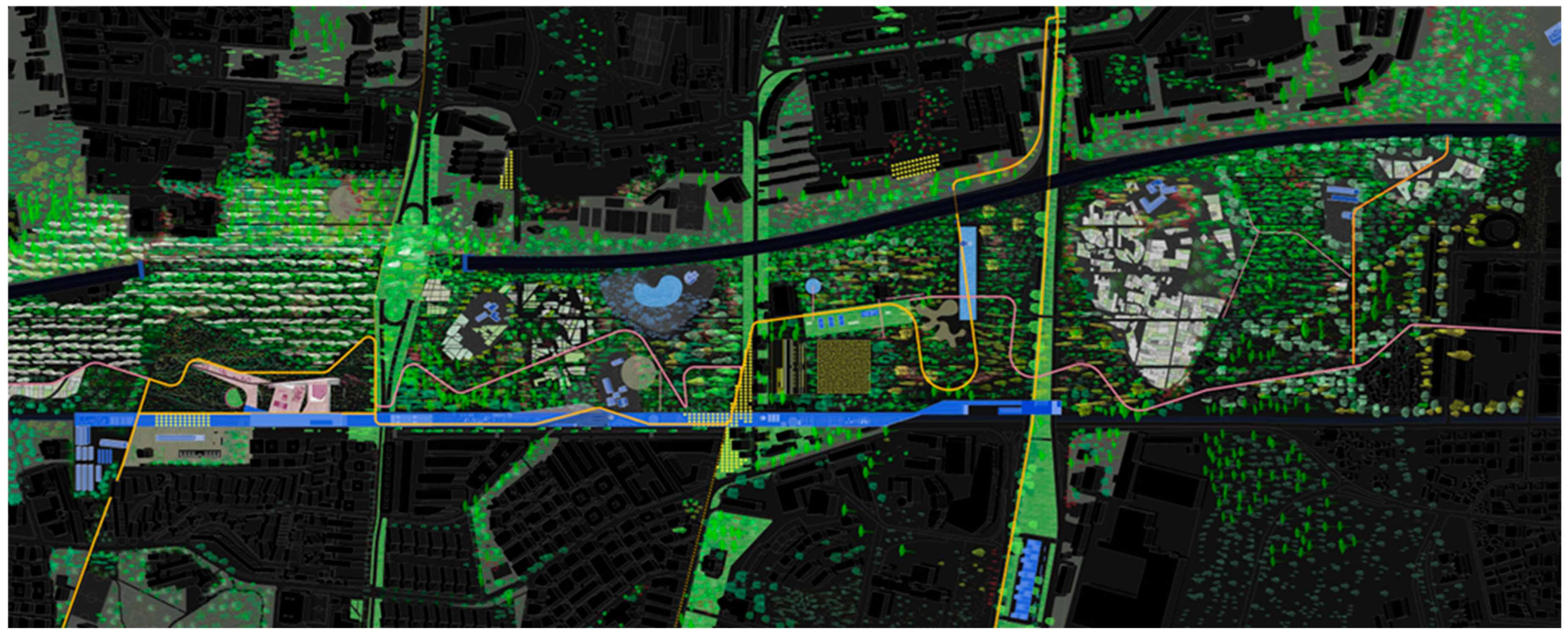
- The need to integrate shaded cycling/walking routes, rail stations as urban nodes, archaeological enhancement (e.g., a large Roman necropolis between Via della Serenissima and Via Basiliano with remains of the ancient Via Collatina, the Aqua Virgo aqueduct, and a votive basin; >2000 tombs and a mausoleum), and attractive public spaces (Figure 12 and Figure 13);
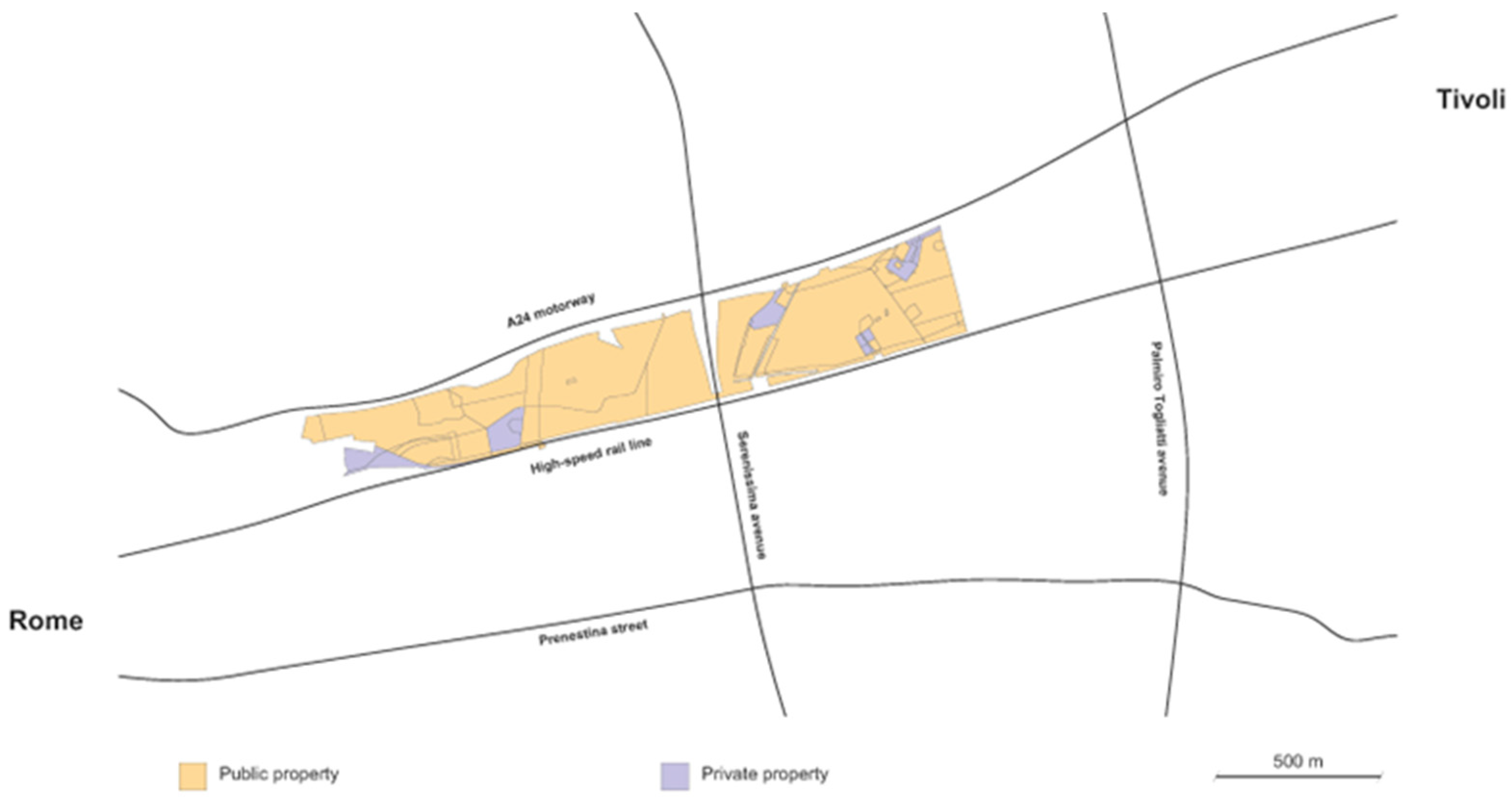
- The analysis of the land registry lots has highlighted that the land ownership is predominantly public, thus facilitating the future construction process (Figure 14).
- Ecological stitching—continuous vegetation between the Aniene Reserve and Centocelle Park via belts, tree rows, and multifunctional hedgerows;
- Green-blue infrastructure—tree systems paired with micro-basins and rainwater channels to support groundwater recharge and runoff control;
- Slow connections—shaded pedestrian and cycling routes linked to future metropolitan greenways and transit stations;
- Social and cultural spaces—areas for cultural, educational, sports, and recreational uses, leveraging proximity to schools and community centers; particularly significant is the archaeological presence;
- Adaptive afforestation—drought-resistant native species (holm oak, downy oak, Celtis, strawberry tree, privet, Rhamnus alaternus) to ensure long-term resilience. The selection of these species is grounded in the site’s Mediterranean thermo-xeric conditions, the heterogeneity of alluvial and compacted soils, and evidence demonstrating the superior drought tolerance, evapotranspirative cooling, and carbon-sequestration performance of native and naturalized taxa in Rome’s eastern peri-urban belt.
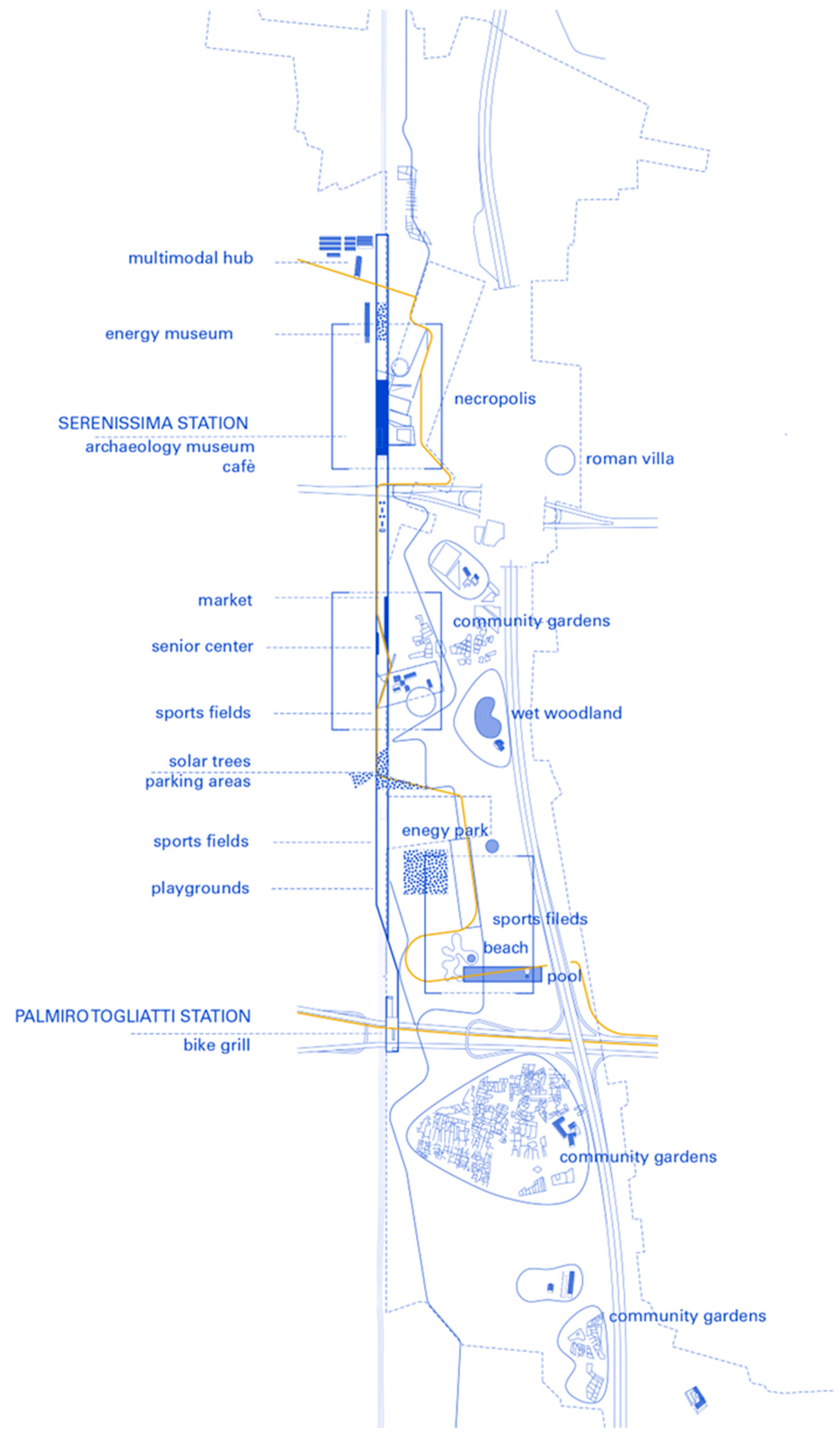
- (a)
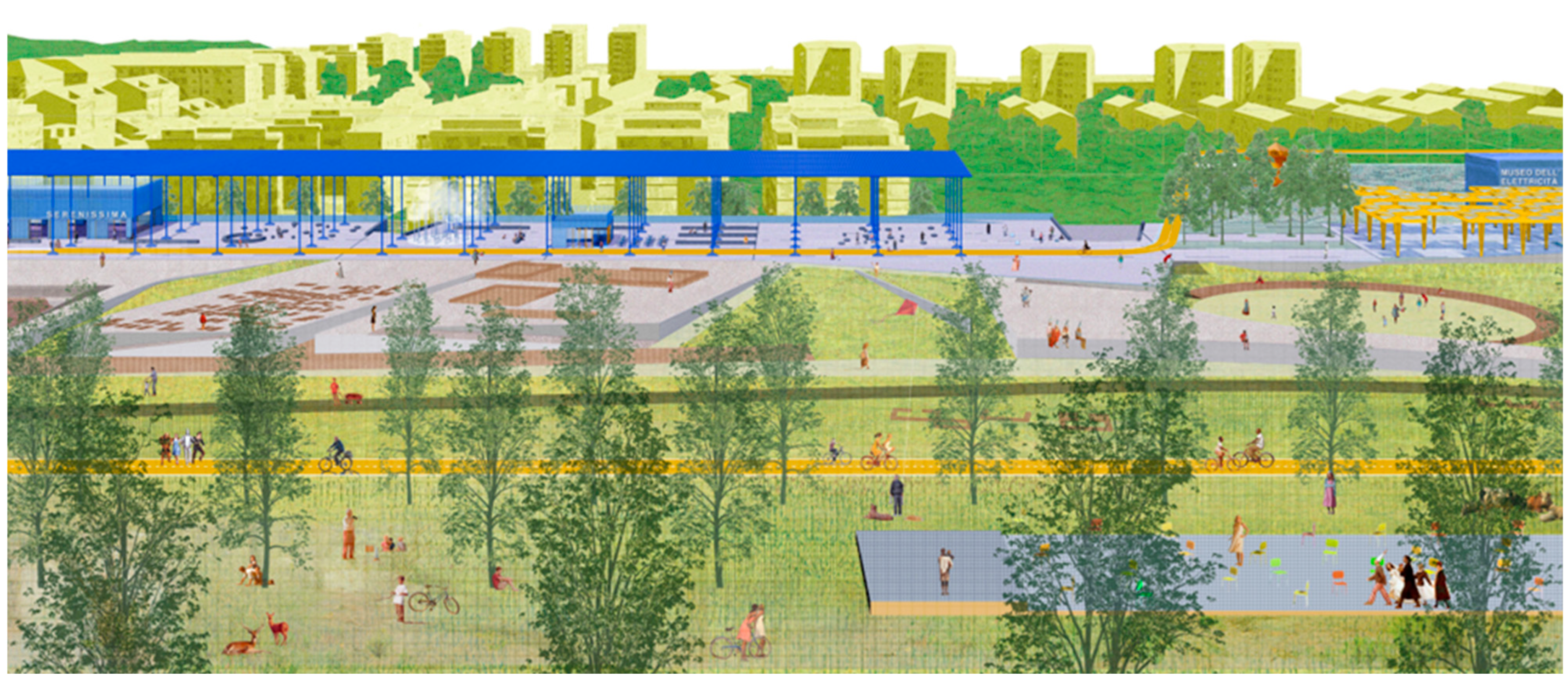
- Rambla Prenestina
- An Electricity Museum (recalling the Acquoria-Serenissima transmission history);
- An Archaeological Interpretation Center;
- Community markets, cafés, and craft spaces;
- Sports fields, play areas, and event platforms;
- Direct station access and multimodal interchange nodes.
- (b)
- Foresta SerenissimaThe second component is a new urban forest composed of approximately 160,000 trees and shrubs, structured into four distinct landscape areas:
- Archaeological Park of the NecropolisAn open woodland and interpretative landscape integrating the Roman funerary complex.
- Forest of MemoryA civic woodland dedicated to remembrance and collective rituals.
- Hygrophilous Forest EnhancementRestoration of wetland species (Quercus robur, Fraxinus angustifolia) to strengthen biodiversity and protect aquatic avifauna.
- Via Scarpitti Cultural LandscapeLandscape enhancement of the villa and casale system with platforms, walking paths, outdoor learning gardens, and ecological shading structures.
- Wooden platforms for performances and outdoor classrooms;
- Sports and play areas;
- A water basin and urban beach;
- A network of urban gardens connecting to Cervelletta Park;
- Continuous tree-lined promenades linking surrounding neighborhoods.
6.3. Systemic Role and Expected Outcomes
- Urban afforestation: creation of approximately 160,000 new trees and shrubs, privileging drought-resistant native species to ensure long-term ecological resilience;
- Carbon sequestration: ≈230,000 tons of CO2 absorbed annually through new woodland systems and improved soil carbon retention;
- Microclimate regulation: 2–4 °C reduction in average summer surface temperatures due to shading, evapotranspiration, and soil permeability;
- Sustainable mobility: implementation of ~2 km of internal slow routes, with planned extensions connecting to:
- -
- the 23 km extra-urban pathway toward Tivoli;
- -
- the 44 km GRAB cycling network encircling the city;
- Social impact: potential direct benefit to ~400,000 residents in Municipalities IV and V, through increased access to equipped public spaces, shaded routes, and community programs;
- Public health benefits: reduction in perceived social isolation and stress through regular exposure to nature, shared outdoor activities, and walkable everyday landscapes;
- Ecological connectivity: establishment of continuous habitat corridors between the Aniene River Reserve, Centocelle Park, Cervelletta Park, and surrounding green patches, enabling biodiversity continuity across the eastern metropolitan sector.
- Enhancement of archaeological and historical landscapes: integration and interpretation of two Roman villas and the largest Republican necropolis, reactivated as accessible cultural public spaces;
- Wetland reinforcement: ecological upgrading of the humid area, supporting hygrophilous plant communities and aquatic avifauna;
- Intermodal civic infrastructure: renovation of the Serenissima, Prenestina, and Togliatti stations as multifunctional hubs linking mobility, public services, and leisure;
- Memory and identity landscapes: creation of a Forest of Memory, dedicated to collective remembrance and civic rituals;
- Productive and social ecologies: valorization of urban gardens (orti urbani) as spaces of community management, education, and local food practices.
- Public realm continuity: creation of a tree-lined urban promenade capable of linking squares, schools, and local services through shaded pedestrian and cycling networks;
- Everyday leisure and community uses: development of water basins and seasonal bathing areas, playgrounds, and sports and gathering platforms, enhancing intergenerational inclusivity and year-round usability;
- Urban forestation networks: coordinated afforestation across adjacent neighborhoods, ensuring continuity beyond park boundaries.
6.4. Significance
- Ecological connectivity;
- Sustainable mobility;
- Heritage interpretation;
- Community stewardship.
7. Conclusions
7.1. General Considerations
- Shared governance frameworks;
- Robust monitoring and mapping tools;
- Participatory and community-based management;
- A clear design vision for landscape continuity.
7.2. Considerations on the Roman Context
- Structuring ecological connectivity across fragmented spaces;
- Enhancing slow mobility networks;
- Integrating heritage layers and memory landscapes;
- mproving climatic comfort and ecological performance;
- Generating new forms of public life.
- A unified metropolitan green framework to overcome administrative fragmentation and align regional, metropolitan, and municipal policies;
- Integration with sustainable mobility and urban-regeneration strategies, enabling afforestation to act as spatial infrastructure rather than isolated planting;
- Co-management and stewardship models involving residents, schools, and associations in maintenance and monitoring;
- Evaluation metrics that combine ecological, spatial, and social performance, alongside traditional environmental indicators;
- Applied research collaborations, such as those developed within NBFC Spoke 5, to link scientific data, ecosystem-service assessment, and design experimentation.
7.3. A Laboratory of Applied Research
- Archaeological constraints, which require selective planting and spatial calibration;
- Residual and infrastructural landscapes, where afforestation must negotiate mobility systems and brownfield conditions;
- Socio-environmental vulnerability, where green infrastructure supports health, identity, and equity.
7.4. Limitations and Future Developments
- The heterogeneity of available datasets across institutions and programs;
- The short temporal horizon of recent afforestation initiatives;
- The absence of consolidated post-implementation monitoring.
- Progressive realization of the Serenissima Park interventions;
- Continuous monitoring of ecological and social indicators;
- Replication across comparable Roman and metropolitan contexts.
Author Contributions
Funding
Institutional Review Board Statement
Informed Consent Statement
Data Availability Statement
Acknowledgments
Conflicts of Interest
References
- Jorgensen, E. Urban Forestry: Tree Management in the City Ecosystem; University of Toronto Press: Toronto, ON, Canada, 1970. [Google Scholar]
- Grey, G.W.; Deneke, F.J. Urban Forestry; Wiley: New York, NY, USA, 1978. [Google Scholar]
- Millennium Ecosystem Assessment (MEA). Ecosystems and Human Well-Being: Synthesis; Island Press: Washington, DC, USA, 2005. [Google Scholar]
- Ulrich, R.S. View through a Window May Influence Recovery from Surgery. Science 1984, 224, 420–421. [Google Scholar] [CrossRef] [PubMed]
- South, E.C.; Hohl, B.C.; Kondo, M.C.; MacDonald, J.M.; Branas, C.C. Effect of Greening Vacant Land on Mental Health of Community-Dwelling Adults: A Cluster Randomized Trial. JAMA Netw. Open 2018, 1, e180298. [Google Scholar] [CrossRef] [PubMed]
- Miller, R.W. Urban Forestry: Planning and Managing Urban Greenspaces; Prentice Hall: Englewood Cliffs, NJ, USA, 1988. [Google Scholar]
- FAO. Guidelines on Urban and Peri-Urban Forestry; Food and Agriculture Organization of the United Nations: Rome, Italy, 2016. [Google Scholar]
- UN-Habitat. The New Urban Agenda (Habitat III, Quito 2016); UN-Habitat: Nairobi, Kenya, 2020. [Google Scholar]
- Kabisch, N.; Korn, H.; Stadler, J.; Bonn, A. Nature-Based Solutions to Climate Change Adaptation in Urban Areas; Springer Open: Cham, Switzerland, 2017. [Google Scholar]
- European Commission. European Green Deal; European Commission: Brussels, Belgium, 2019. [Google Scholar]
- European Commission. EU Biodiversity Strategy for 2030: Bringing Nature Back into Our Lives; European Commission: Brussels, Belgium, 2020. [Google Scholar]
- U.S. Department of Agriculture, Forest Service. Urban and Community Forestry Program: Report to Congress; USDA Forest Service: Washington, DC, USA, 1990; Publication No. FS–463.
- Administration of China State Forestry. National Forest City Program Implementation Plan; State Forestry Administration (SFA): Beijing, China, 2004. (In Chinese)
- Cimini, A.; De Fioravante, P.; Marinosci, I.; Congedo, L.; Cipriano, P.; Dazzi, L.; Marchetti, M.; Scarascia-Mugnozza, G.; Munafò, M. Green Urban Public Spaces Accessibility: A Spatial Analysis for the Urban Area of the 14 Italian Metropolitan Cities Based on SDG Methodology. Land 2024, 13, 2174. [Google Scholar] [CrossRef]
- Italian Republic. Decree-Law 111/2019, Converted into Law 141/2019; Italian Republic: Rome, Italy, 2019.
- Comune di Milano. Forestami: Rapporto sullo Stato di Avanzamento 2023–2024; Comune di Milano: Milan, Italy, 2024.
- Available online: https://www.comune.bologna.it/novita/comunicati-stampa/piano-dazione-lenergia-sostenibile-e-il-clima-parte-la-transizione-ecologica-bologna? (accessed on 6 September 2025).
- Regione Lazio. Progetto Ossigeno–Rapporto Triennale; Regione Lazio: Rome, Italy, 2023.
- Città Metropolitana di Roma Capitale. Piano di Forestazione Urbana e Periurbana; Città Metropolitana di Roma Capitale: Rome, Italy, 2022.
- Elmqvist, T.; Fragkias, M.; Goodness, J.; Güneralp, B.; Marcotullio, P.J.; McDonald, R.I.; Parnell, S.; Schewenius, M.; Sendstad, M.; Seto, K.C.; et al. Urbanization, Biodiversity and Ecosystem Services; Springer: Dordrecht, The Netherlands, 2015. [Google Scholar]
- Anguelovski, I.; Connolly, J.T.; Brand, A. Green Gentrification: Urban Sustainability and the Struggle for Environmental Justice; Routledge: London, UK, 2020. [Google Scholar]
- Bell, S.; Blom, D.; Rautamäki, M.; Castel-branco, C.; Simson, A.; Olsen, I. Design of Urban Forests. In Urban Forest and Trees; Springer: Berlin/Heidelberg, Germany, 2005; pp. 149–186. [Google Scholar]
- Gill, S.E.; Handley, J.F.; Ennos, A.R.; Pauleit, S. Adapting cities for climate change: The role of the green infrastructure. Built Environ. 2007, 33, 115–133. [Google Scholar] [CrossRef]
- McPherson, E.G.; Simpson, J.R. Urban tree energy-use and car-bon-emission reductions: A meta-analysis. Urban For. Urban Green. 2005, 4, 115–123. [Google Scholar]
- Mostafavi, M.; Doherty, G. (Eds.) Ecological Urbanism; Harvard Graduate School of Design/Lars Müller: Cambridge, MA, USA, 2010. [Google Scholar]
- Low, S.; Taplin, D.; Scheld, S. Rethinking Urban Parks: Public Space and Cultural Diversity; University of Texas Press: Austin, TX, USA, 2005. [Google Scholar]
- Spirn, A.W. The Language of Landscape; Yale University Press: New Haven, CT, USA, 1998. [Google Scholar]
- Wolch, J.R.; Byrne, J.; Newell, J.P. Urban green space, public health, and environmental justice. Landsc. Urban Plan. 2014, 125, 234–244. [Google Scholar] [CrossRef]
- Cohen-Shacham, E.; Walters, G.; Janzen, C.; Maginnis, S. Nature-Based Solutions to Address Global Societal Challenges; IUCN: Gland, Switzerland, 2016. [Google Scholar]
- Nowak, D.J.; Greenfield, E.J. Tree and impervious cover in the United States. Landsc. Urban Plan. 2012, 107, 21–30. [Google Scholar] [CrossRef]
- Waldheim, C. Landscape as Urbanism: A General Theory; Princeton University Press: Princeton, NJ, USA, 2016. [Google Scholar]
- Available online: https://www.comune.roma.it/web/it/scheda-servizi.page?contentId=INF1027734&stem=verde_urbano (accessed on 6 September 2025).
- Available online: https://www.comune.roma.it/web/it/scheda-servizi.page?contentId=INF1167153&stem=verde_urbano (accessed on 6 September 2025).
- Di Cristofaro, M.; Di Pirro, E.; Ottaviano, M.; Marchetti, M.; Lasserre, B.; Sallustio, L. Greener, Exploring the Trends of Sealed and Permeable Spaces Availability in Italian Built-Up Areas during the Last Three Decades. Forests 2022, 13, 1983. [Google Scholar] [CrossRef]
- Di Cristofaro, M.; Moresi, F.V.; Maesano, M.; Portoghesi, L.; Munafò, M.; De Fioravante, P.; Tonti, D.; Ottaviano, M.; Marchetti, M.; Scarascia-Mugnozza, G. Mapping Coverage and Typology of Forests in Latium Region, Central Italy. Land 2025, 14, 331. [Google Scholar] [CrossRef]
- Lanfredi, M.; Coluzzi, R.; Imbrenda, V.; Nosova, B.; Giacalone, M.; Turco, R.; Prokopovà, M.; Salvati, L. In-between Environmental Sustainability and Economic Viability: The Italian Forestry Sector. Land 2023, 12, 1001. [Google Scholar] [CrossRef]
- Echeverri, A.; Orsini, F. Green Corridors of Medellín: Urban Ecology and Social Inclusion in Latin America; Universidad Nacional de Colombia: Medellín, Colombia, 2019. [Google Scholar]
- City of Philadelphia. Philly Tree Plan: Philadelphia’s Urban Forest Strategic Plan 2023–2035; City of Philadelphia: Philadelphia, PA, USA, 2023.
- Available online: https://phsonline.org/programs/transforming-vacant-land (accessed on 10 October 2025).
- Available online: https://phsonline.org/for-gardeners/gardeners-blog/philadelphia-vacant-lots-green-community-spaces (accessed on 10 October 2025).
- Available online: https://forestami.org/mappatura/ (accessed on 9 October 2025).
- Available online: https://forestami.org/piantagione/milano-via-chiasserini/ (accessed on 9 October 2025).
- Capuano, A.; Frediani, D.; Giancotti, A.; Giovannelli, A. (Eds.) Proceedings of the GRAB The City, Catalogue of the Exhibition at the National Gallery of Modern and Contemporary Art, Tlon Città di Castello, Rome, Italy, 22 February–1 April 2024; Tlon: Città di Castello, Italy, 2024. [Google Scholar]
- Clemente, M.; Pignatti, G.; Degaetano, M.; Corona, P. A “Street Tree” Master Plan for the Strategic Management of Linear Reforestation and Urban Landscape Enhancement in Rome, Italy. Land 2025, 14, 606. [Google Scholar] [CrossRef]
- Clemente, M. Street Tree Redevelopment in Rome’s Historical Landscapes: From Strategic Vision to Streetscape Design. Land 2025, 14, 233. [Google Scholar] [CrossRef]



| Area | Program | Timeframe | Scale | Outputs to Date | Targets | Typical Densities |
|---|---|---|---|---|---|---|
| Regione Lazio | Ossigeno | 2019→ | Regional (grants) | 445+ projects; latest call ≈42,000 plants; ≈4000 tCO2/yr | 6 million trees (regional) | Small sites; 10–12 trees per intervention |
| Roma Capitale | Forest for Rome | 2022→ | City (diffuse) | Micro-forests on residual land | CO2 & UHI mitigation | ≈10 trees/intervention; ≈40 tCO2/yr (est.) |
| Roma Capitale | Riforestiamo Roma | 2024–2025 | City (street trees) | ≈5800 trees planted in 2024 | 9500 by 2025 | — |
| Roma Capitale | Managed stock (census) | 2016 baseline | City | ≈312,583 municipal trees; ≈4000 ha | — | ≈78 trees/ha |
| Città Metropolitana di Roma | Metropolitan Forestry/PNRR | 2024→ | Metro area (incl. Rome) | ≈1,000,000 plants on ≈930 ha (≈1075/ha) | New urban/peri-urban woods and corridors | — |
| City | Program | Timeframe | Scale | Physical Outputs | Target/Goal | Measured/Estimated Benefits |
|---|---|---|---|---|---|---|
| Medellín (CO) | Green Corridors | 2016–2019 (phase 1) | City (linear network) | 30 corridors, ≈20 km, ≈65 ha, ≈8800 trees/palms | Heat-island mitigation; ecological connectivity | ≈−2 °C avg. temp. reduction; PM2.5 21.81→20.26 μg/m3 |
| Philadelphia (US) | Philly Tree Plan | 2023–2053 | Citywide strategy | Canopy-based (no fixed tree count) | 30% canopy in every neighborhood (baseline ≈20%) | US$25.5 M/yr; ≈1000 jobs; ≈400 avoided deaths/yr; heat gaps ≈ 12 °C |
| Milan (IT) | Forestami | 2019–2030 | Metropolitan area (133 municipalities) | 611,459 plants (2024); ≈1000–1200/ha new woods | 3 million by 2030; +4 pp canopy | ≈5 Mt CO2/yr absorption (2030 projection) |
Disclaimer/Publisher’s Note: The statements, opinions and data contained in all publications are solely those of the individual author(s) and contributor(s) and not of MDPI and/or the editor(s). MDPI and/or the editor(s) disclaim responsibility for any injury to people or property resulting from any ideas, methods, instructions or products referred to in the content. |
© 2025 by the authors. Licensee MDPI, Basel, Switzerland. This article is an open access article distributed under the terms and conditions of the Creative Commons Attribution (CC BY) license (https://creativecommons.org/licenses/by/4.0/).
Share and Cite
Capuano, A.; Sorrentino, M. Urban Afforestation as Spatial Strategy: Applied Design Research on the Eastern Greenway in Rome. Sustainability 2025, 17, 10574. https://doi.org/10.3390/su172310574
Capuano A, Sorrentino M. Urban Afforestation as Spatial Strategy: Applied Design Research on the Eastern Greenway in Rome. Sustainability. 2025; 17(23):10574. https://doi.org/10.3390/su172310574
Chicago/Turabian StyleCapuano, Alessandra, and Marco Sorrentino. 2025. "Urban Afforestation as Spatial Strategy: Applied Design Research on the Eastern Greenway in Rome" Sustainability 17, no. 23: 10574. https://doi.org/10.3390/su172310574
APA StyleCapuano, A., & Sorrentino, M. (2025). Urban Afforestation as Spatial Strategy: Applied Design Research on the Eastern Greenway in Rome. Sustainability, 17(23), 10574. https://doi.org/10.3390/su172310574


