Article

Ecological Suitability Modeling of Sweet Cherry (Prunus avium L.) in the Fez-Meknes Region of Morocco Under Current Climate Conditions

1
Research Unit of Plant Breeding and Plant Genetic Resources Conservation, Regional Agricultural Research Center of Meknes, National Institute of Agricultural Research, P.O. Box 415, Rabat 10090, Morocco
2
Laboratory: Natural Resources and Sustainable Development, Department of Biology, Faculty of Science, University Ibn Tofail, P.O. Box 133, Kenitra 14000, Morocco
3
School of Science and Engineering, Al Akhawayn University, P.O Box 104, Ifrane 53000, Morocco
4
Laboratory of Biotechnologies and Valorization of Natural Resources, Faculty of Sciences-Agadir, University of Ibn Zohr, P.O. Box 32/S, Agadir 80000, Morocco
5
Provincial Service for the Implementation of the Agricultural Council of Azrou, National Office of the Agricultural Council (ONCA), P.O. Box 6672, Rabat 10000, Morocco
*
Author to whom correspondence should be addressed.
Sustainability 2025, 17(23), 10573; https://doi.org/10.3390/su172310573
Submission received: 4 July 2025 / Revised: 5 August 2025 / Accepted: 28 August 2025 / Published: 25 November 2025

Abstract

Sweet cherry (Prunus avium L.), a temperate fruit species highly sensitive to thermal and hydric stress, faces increasing cultivation challenges in semi-arid regions such as Fez-Meknes (Morocco) due to climate change. This study aims to identify ecologically suitable zones for sweet cherry cultivation by modeling its current potential distribution using the MaxEnt (Maximum Entropy) approach. A total of 1151 georeferenced occurrence records were collected through field surveys and validated with satellite imagery. Nineteen bioclimatic variables from the WorldClim database were initially considered, and a subset with low multicollinearity (|r| < 0.7) was retained for analysis. Model performance, evaluated using the area under the ROC curve (AUC), yielded a high mean value of 0.960 ± 0.014, indicating excellent predictive accuracy. Elevation, annual precipitation (BIO12), and precipitation seasonality (BIO15) emerged as key drivers of the species’ distribution, as confirmed by both Jackknife and SPCPI analyses. Spatial prediction maps highlighted high-suitability zones in the provinces of Ifrane, El Hajeb, Azrou, and Sefrou, aligning with known agro-climatic production areas. In contrast, lower suitability was observed in more arid or heat-prone provinces such as Boulemane and Midelt. These findings provide a robust bioclimatic framework for agroecological planning, supporting adaptive varietal zoning and long-term planning for climate-resilient horticulture.

1. Introduction

Sweet cherry (Prunus avium L.), a temperate deciduous tree of the Rosaceae family, is widely recognized for its agronomic, nutritional, and commercial value. Beyond its economic importance, sweet cherry fruit is rich in bioactive compounds, including polyphenols, anthocyanins, and vitamin C, which contribute to its rising demand in both fresh and processed fruit markets [1,2]. As a perennial woody crop, P. avium is especially sensitive to climatic conditions due to its high chilling requirement during dormancy, a prerequisite for synchronized bud break, flowering, and successful fruit set [3,4,5].
Dormancy in cherry trees includes endodormancy, governed by endogenous hormonal controls, and ecodormancy, driven by external environmental conditions, particularly temperature and photoperiod [2,6]. The accumulation of sufficient winter chilling, quantified in chilling hours or units, is critical to overcoming endodormancy. Inadequate chilling leads to a cascade of physiological disorders including irregular flowering, floral bud abortion, reduced spur formation, and uneven fruit development [7,8]. These physiological constraints make sweet cherry highly vulnerable to ongoing climate change, particularly in semi-arid and Mediterranean climates where winter chill is decreasing [9,10,11].
In Morocco, sweet cherries are cultivated on approximately 3064 hectares, with an annual production of about 141,444 tons [12]. The crop plays a central socio-economic role in mountainous regions such as Ifrane, Azrou, El Hajeb, and Sefrou, where altitude and climate favor sufficient chilling accumulation [9]. However, the varietal profile remains limited, with cultivation dominated by Bigarreau group cultivars, such as ‘Burlat’, ‘Van’, and ‘Napoleon’, which generally require more than 800–1000 chilling hours to achieve optimal performance [10,13].
The national trend of expanding cherry cultivation into lower-altitude and warmer areas has produced mixed results. Farmers in regions such as Midelt, Boulemane, and Taounate report symptoms of insufficient dormancy release, including delayed bud break, apical dominance, low fruit set, and irregular vegetative growth [3]. These observations align with experimental evidence showing that warm winters disrupt hormonal balances, impair vascular development within buds, and reduce floral viability [5,6,10]. The vulnerability of the cherry phenological cycle under climate stress is further compounded by irregular precipitation patterns, early spring frosts, and heatwaves during flowering and ripening periods [14]. Despite the well-documented vulnerability of sweet cherry to climatic anomalies, the use of ecological modeling tools in agricultural planning remains limited in North Africa. Previous research has shown the potential of species distribution models (SDMs) to identify suitable areas for fruit tree cultivation under both current and future climate scenarios [15,16,17]. Among the different approaches for modeling species distribution, the MaxEnt (Maximum Entropy) model has become a reference tool owing to its robustness and predictive capacity, particularly when only presence data and environmental variables are available [18,19,20]. Grounded in the principle of maximum entropy, MaxEnt is especially valuable for ecological and agricultural studies, as it allows reliable modeling even with a limited number of occurrence records and offers high flexibility in handling complex environmental variables [20]. Nonetheless, its application requires careful consideration of potential sampling biases and thoughtful variable selection to minimize overfitting. The model has been successfully employed to map the potential distribution of several temperate fruit species, including apricot (Prunus armeniaca), pomegranate (Punica granatum), and almond (Prunus dulcis) [21,22,23].
Given the ongoing shifts in temperature and precipitation regimes in Morocco [13,24], there is an urgent need to reassess the ecological suitability of both current and potential cherry production zones. The Fez-Meknes region, which accounts for over 50% of national cherry output, presents a highly variable agroecological landscape, making it an ideal case study for modeling the climatic niche of P. avium. Despite its traditional suitability, the region has recently witnessed a marked decline in cherry productivity—estimated at 30% in 2021 and 47% in 2023—primarily due to insufficient winter chilling [12]. Moreover, the growing shift toward more resilient species such as olive, often at the expense of cherry, underscores the need for scientifically grounded spatial planning [25].
Building on this context, this study aims to undertake the following:
(i)
model the current potential distribution of Prunus avium in the Fez-Meknes region using the MaxEnt algorithm;
(ii)
identify the key environmental variables shaping its ecological niche, with a focus on winter chilling requirements and water availability;
(iii)
delineate priority zones for sustainable cherry cultivation under current climatic conditions;
(iv)
provide practical recommendations for varietal selection, agroecological zoning, and long-term adaptation strategies to climate change;
(v)
develop a decision-support tool that integrates field occurrence data, high-resolution environmental variables, and robust statistical modeling, targeting agronomists, land-use planners, and agricultural stakeholders.

2. Materials and Methods

2.1. Study Site

The Fez-Meknes region, located in north-central Morocco, covers an area of approximately 40,075 km2, representing 5.7% of the national territory. It is characterized by pronounced geographical and climatic diversity, ranging from the fertile Saïs plains and peri-urban belts of Fez and Meknes to the Pre-Rif hills, the Middle Atlas and Zerhoun mountain ranges, and southern oasis systems. These agroecological zones include both lowland and montane environments, collectively supporting a wide array of agricultural practices [26].
Home to approximately 4.2 million inhabitants—nearly 12% of the national population—the region experiences cold winters in mountainous areas and hot, arid summers in the lowlands, creating a mosaic of microclimates favorable for the niche-based modeling of fruit tree species [26].
Agriculture plays a pivotal role in the regional economy, contributing 21.1% to the regional GDP and employing over 30% of the workforce [27,28]. Of the estimated 1.3 million hectares of utilized agricultural land, around 200,000 hectares are irrigated [25]. The region also benefits from major hydraulic infrastructures, including the Allal El Fassi, Idriss I, and Sahla dams, which support both irrigation and potable water supply.
Figure 1 provides an overview of the agroecological zoning and spatial extent of the study area.

2.2. Acquisition and Processing of Occurrence Data

Data on the spatial distribution of sweet cherry (Prunus avium L.) were collected through systematic field surveys across both major and minor cultivation zones of the Fez-Meknes region. Georeferenced coordinates (latitude and longitude) were recorded using handheld GPS devices and validated via high-resolution satellite imagery in Google Earth. Spatial data were processed in QGIS to ensure positional accuracy and consistency.
To enhance data quality and minimize spatial redundancy, a filtering procedure was applied: duplicate records and closely clustered points were removed, retaining only one occurrence per 1 km2 grid cell in line with best practices for reducing spatial autocorrelation in species distribution modeling [29]. The final dataset included 1151 unique, spatially independent records, stored in CSV format and structured for compatibility with MaxEnt [30,31].

2.3. Environmental Data for Cherry Distribution

The modeling framework incorporated 19 bioclimatic variables and 1 topographic variable (elevation), all sourced from the WorldClim database (http://www.worldclim.org; accessed on 2 March 2025) at a spatial resolution of 30 arc-seconds (≈1 km2) [32,33,34] (Table 1). These predictors represent temperature and precipitation patterns, seasonal variability, and climatic extremes, which are critical for characterizing the ecological requirements of Prunus avium [3].
All raster layers were standardized to the WGS84 coordinate system to ensure geospatial alignment [35]. From the elevation dataset, slope and aspect were derived to account for local microclimatic influences on species persistence. Finally, all raster files were converted to ASCII (.asc) format for compatibility with MaxEnt input requirements [22,36], enabling seamless integration of environmental predictors.

2.4. Ecological Niche Modeling with MaxEnt

Ecological niche modeling was performed using MaxEnt version 3.4.1 [37,38]. In total, 70% of the occurrence records were used for training and 30% for testing. The maximum number of iterations was set to 1000, and the logistic output format, producing habitat suitability values between 0 and 1, was selected. To ensure robustness, ten replicate runs were conducted with randomized seed generation [34].
Model performance was evaluated using the Area Under the Receiver Operating Characteristic Curve (AUC), with AUC values > 0.9 indicating the high discriminative power of the model [16,39]. Final outputs were exported as raster layers in ASCII format for subsequent spatial analysis in QGIS [40].
For interpretation, logistic suitability scores were reclassified into ten ordinal classes, ranging from very low (0.0–0.1) to very high (>0.9). Areas with a predicted probability of occurrence greater than 0.6 were defined as optimal for sweet cherry cultivation, following empirical thresholds reported in previous modeling studies [16,41].

2.5. Variable Importance Assessment

To determine which environmental variables most strongly influenced the distribution of Prunus avium, the built-in Jackknife test in MaxEnt was applied. This method assessed model gain and AUC changes when each variable was excluded or used individually [42,43]. Additionally, the Sum of Percentage Contribution and Permutation Importance (SPCPI) was calculated for each predictor to quantify its relative explanatory power. Variables with SPCPI values exceeding 25% were identified as the primary determinants of the species’ ecological niche [22,44].

3. Results

3.1. Selection of Non-Redundant Bioclimatic Variables

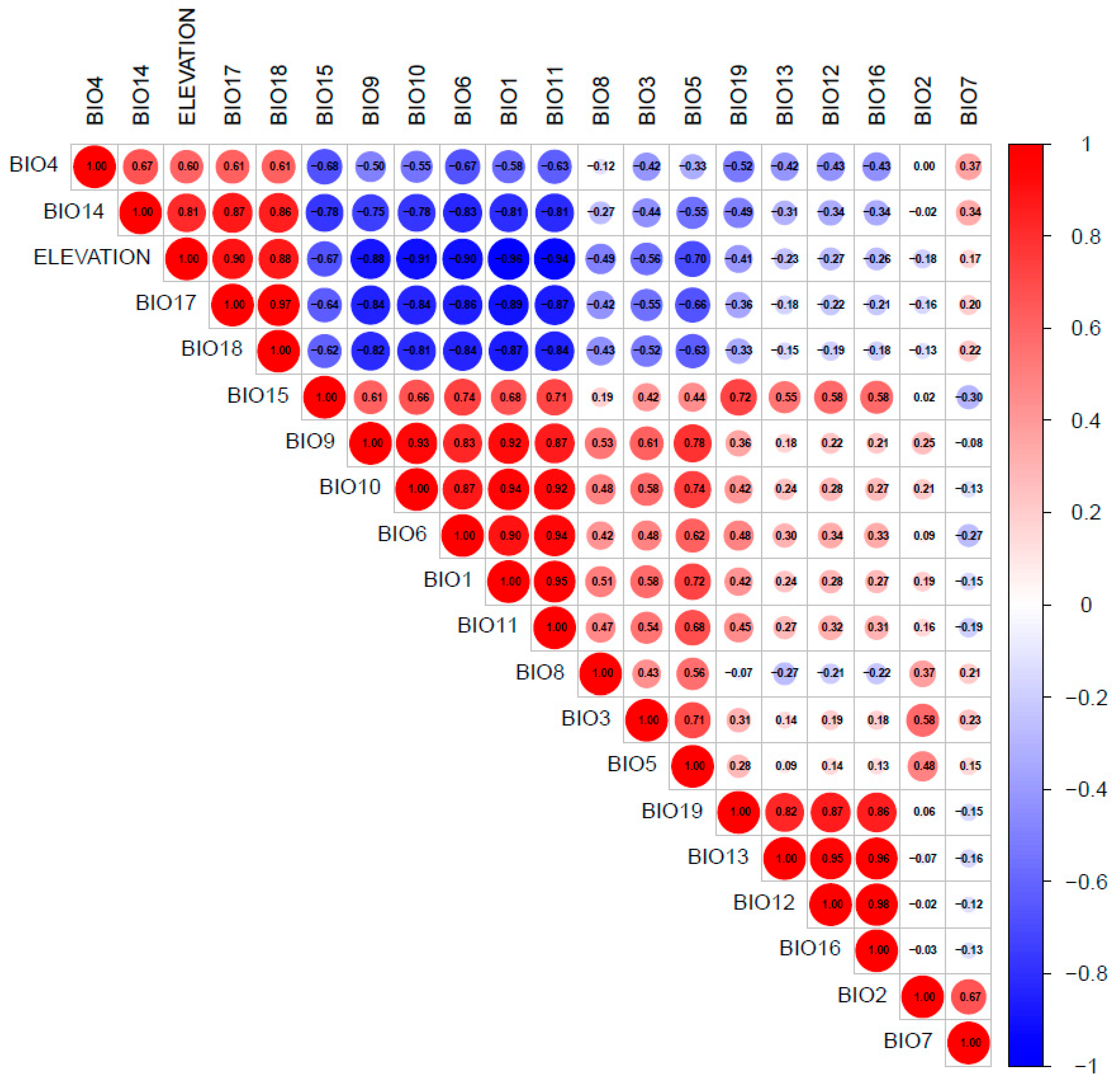
To enhance model accuracy and minimize multicollinearity, Pearson correlation coefficients (|r| ≥ 0.7) were calculated among the 19 initial bioclimatic variables and elevation. Strong intercorrelations were observed, particularly among temperature-related indices (BIO1, BIO5, BIO6, BIO10, BIO11) and precipitation-related metrics (BIO13 (precipitation of wettest month), BIO16, BIO19). Based on both ecological relevance and statistical independence, a final subset of ten variables was selected for MaxEnt modeling (|r| < 0.7): BIO1, BIO2, BIO3, BIO5, BIO7, BIO8, BIO12, BIO15, BIO18, and Elevation (Figure 2).

3.2. Model Performance and Predictive Accuracy

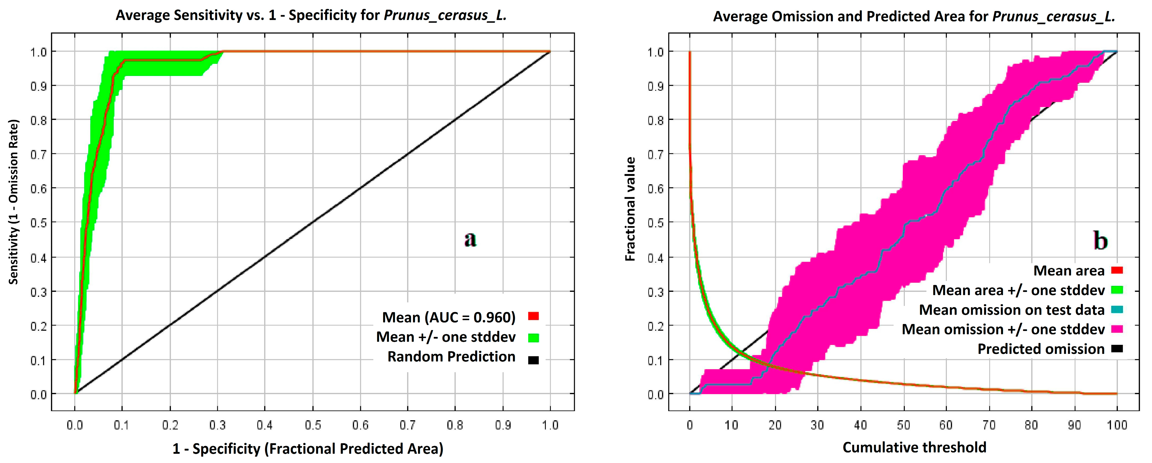
The MaxEnt model exhibited excellent predictive performance, with a mean Area Under the Curve (AUC) of 0.960 ± 0.014 across ten replicate runs (Figure 3a). This high AUC indicates a strong capability to differentiate between suitable and unsuitable habitats for Prunus avium. The omission rate versus predicted area curve (Figure 3b) further validated the model’s reliability, showing minimal divergence between expected and observed omission rates across cumulative thresholds.
To reduce potential sampling biases and enhance robustness, a spatially stratified approach was used to generate background (pseudo-absence) points. This method better captured the spatial heterogeneity of environmental conditions in the study area, mitigating bias from uneven sampling efforts and improving the ecological relevance of model predictions.
Overall, these results confirm the MaxEnt model’s statistical robustness and reliability under current climatic conditions [39].

3.3. Variable Importance: Jackknife and SPCPI Analysis

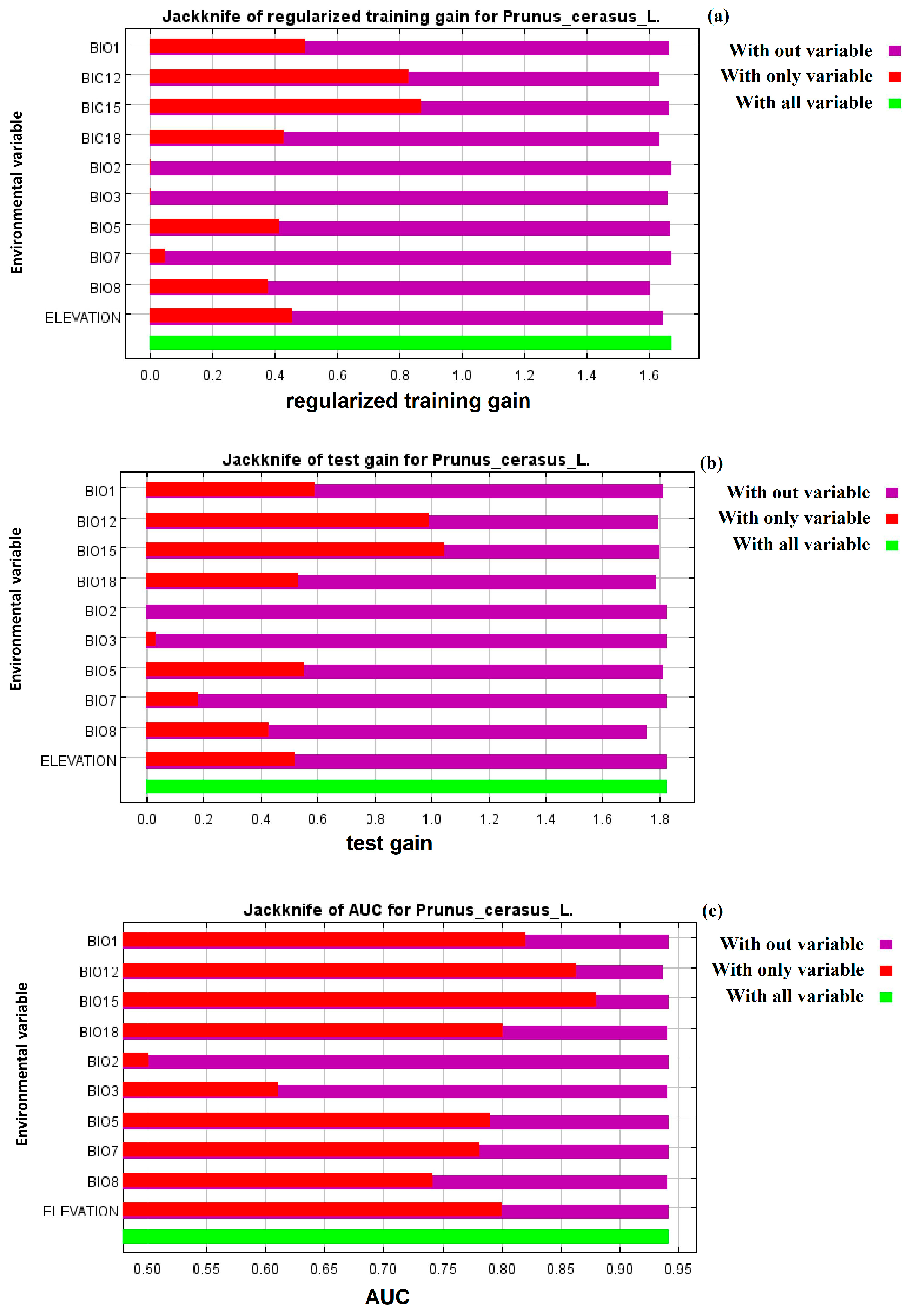
Jackknife analysis identified elevation as the most influential variable, yielding the highest training gain and AUC when used alone and causing a significant drop in model performance when excluded (Figure 4a–c). Climatic variables such as annual precipitation (BIO12) and precipitation seasonality (BIO15) also contributed strongly, particularly reflected in test gain and AUC values, highlighting their predictive importance.
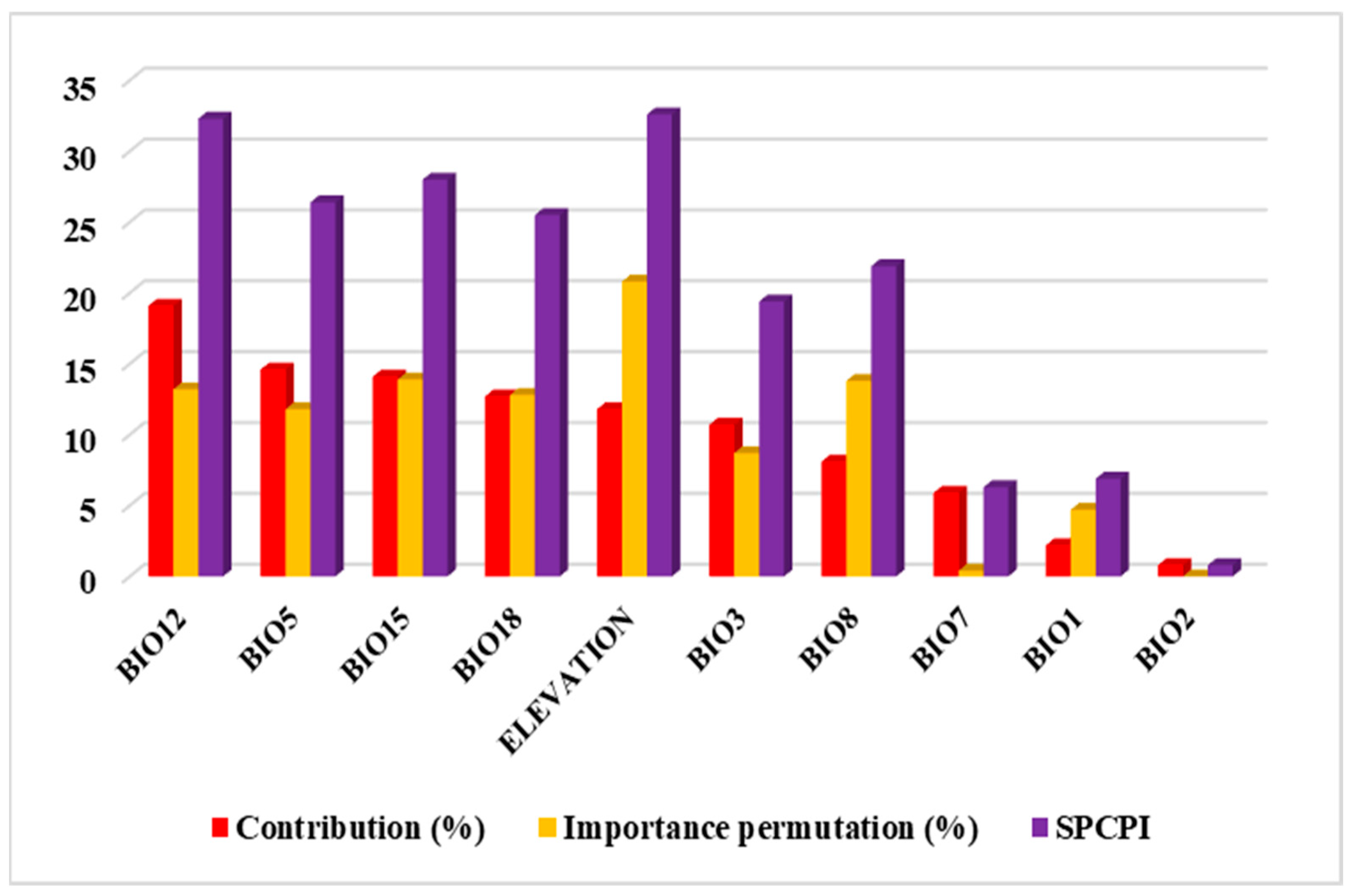
The ranking based on the Sum of Percentage Contribution and Permutation Importance (SPCPI) corroborated these results (Figure 5). The top five variables were Elevation (SPCPI = 32.6%), BIO12—Annual Precipitation (32.3%), BIO15—Precipitation Seasonality (28.0%), BIO5—Maximum Temperature of the Warmest Month (26.4%), and BIO18—Precipitation of the Warmest Quarter (25.5%). Variables with SPCPI below 10% (e.g., BIO1, BIO2) were considered marginal or redundant in defining the species’ ecological niche (Table 2).

3.4. Species-Environment Response Patterns

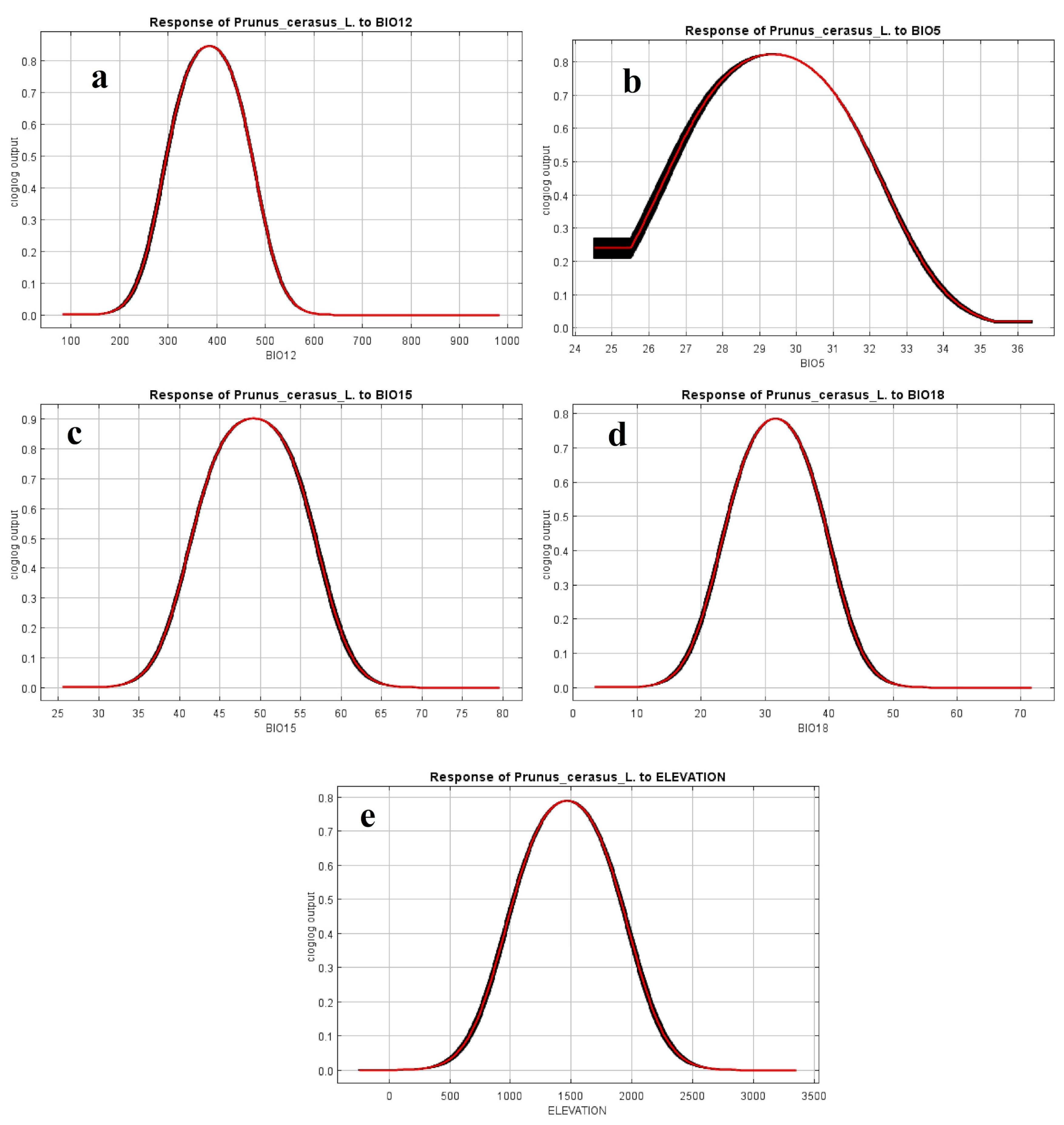
The response curves generated by MaxEnt for the five most influential predictors revealed ecophysiologically meaningful thresholds for Prunus avium occurrence (Figure 6):
  • BIO12 (Annual Precipitation): Optimal occurrence probability peaked at approximately 400 mm/year, indicating a preference for moderately humid climates.
  • BIO5 (Maximum Temperature of Warmest Month): Suitability declined sharply above 32 °C, with an optimal range between 28 and 31 °C.
  • BIO15 (Precipitation Seasonality): The species favored moderate seasonality (index ~50), suggesting intolerance to highly irregular rainfall patterns.
  • BIO18 (Precipitation of Warmest Quarter): High suitability corresponded to summer precipitation between 25 and 38 mm, highlighting drought sensitivity.
  • Elevation: Occurrence probabilities peaked between 1000 and 1800 m, consistent with the altitudinal range of traditional Moroccan cherry orchards.
These response curves highlight Prunus avium’s combined sensitivity to thermal stress, water availability, and elevation-linked chilling accumulation.

3.5. Spatial Distribution of Suitable Habitats

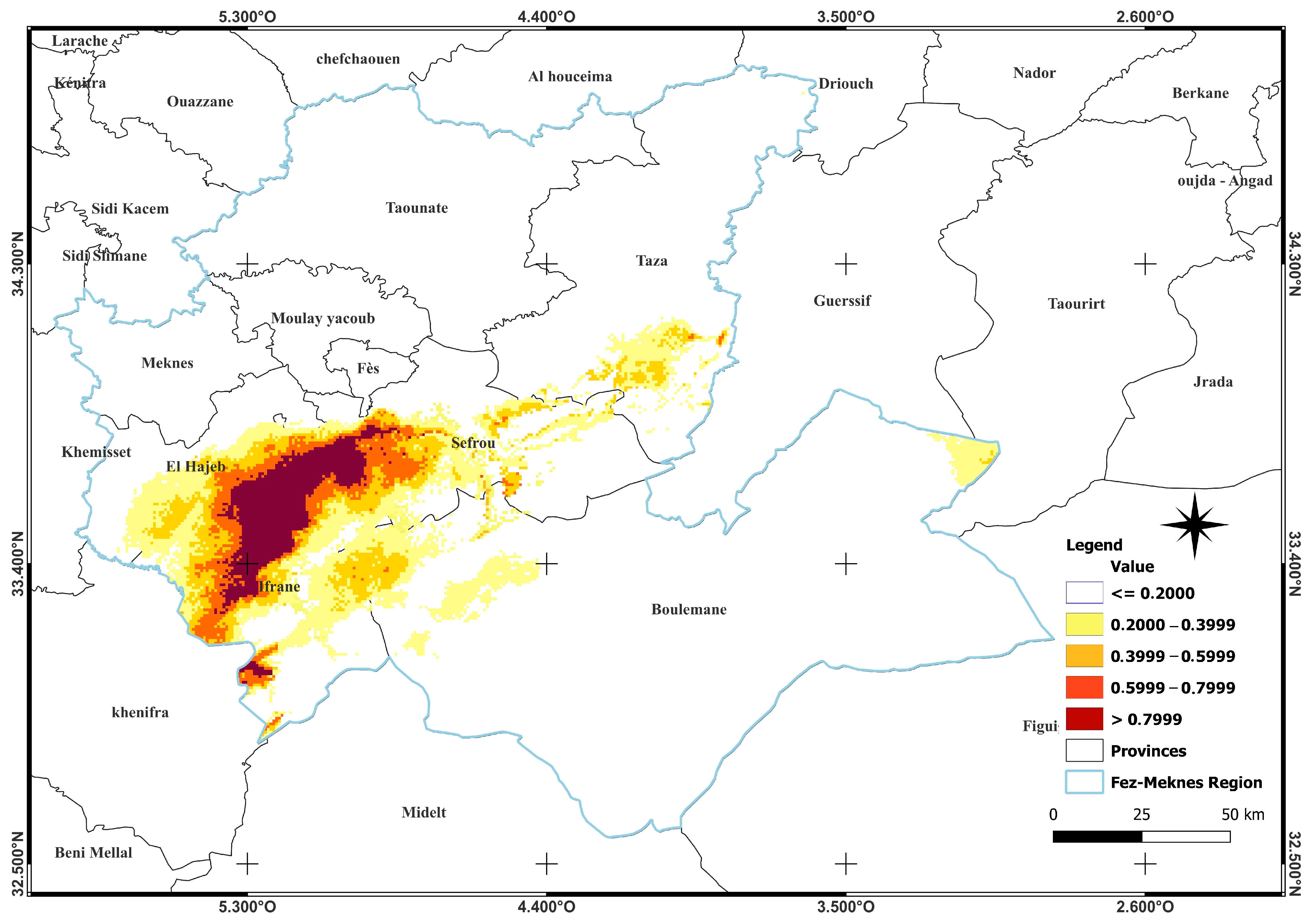
The final suitability map (Figure 7) highlights spatially explicit zones for potential cherry cultivation:
  • Highly Suitable Areas (>0.7999 probability): Concentrated in the mountainous provinces of Ifrane, Azrou, El Hajeb, and Sefrou, typically above 1200 m altitude, where precipitation and temperature conditions are optimal.
  • Moderately Suitable Areas (0.5999–0.7999): Located in foothill regions between 900 and 1200 m, potentially suitable for lower-chill cultivars.
  • Low Suitability Areas (<0.4): Found in arid or low-altitude zones such as Boulemane, Midelt, and Taounate, where extreme heat and insufficient chilling make cherry cultivation risky.
This spatial model offers valuable guidance for land-use planners and agricultural policymakers aiming to optimize cherry production under current climatic conditions.

4. Discussion

Sweet cherry (Prunus avium L.), a temperate deciduous species of high economic and nutritional value, is highly sensitive to specific climatic and topographic conditions, especially in regions like Fez-Meknes that are increasingly impacted by climate variability. This study used ecological niche modeling to delineate suitable areas for cherry cultivation and to identify the key environmental factors shaping its current distribution. The results offer valuable insights for both fundamental biogeography and applied agricultural planning in the context of climate change.

4.1. Comparative Modeling Performance

The MaxEnt model achieved a high mean AUC of 0.960 ± 0.014, demonstrating excellent ability to discriminate suitable habitats for Prunus avium L. This performance surpasses that reported in previous cherry distribution studies [15,45], likely due to the careful selection of non-collinear variables, precise georeferenced occurrence data, and the inclusion of ecologically relevant bioclimatic predictors tailored to Morocco’s Mediterranean and montane environments. The model’s robustness is further supported by low omission rates and consistent Jackknife test results, which confirm the critical role of the selected variables in defining the species’ ecological niche.

4.2. Climatic Constraints and Altitudinal Dependency

Elevation emerged as a major predictor, with suitable areas predominantly located above 1200 m. These zones offer optimal conditions for chilling accumulation (>800–1000 h), a known requirement for flowering and fruiting in P. avium. This result aligns with the species’ physiological dependence on winter cold for dormancy release [4,14,46]. The distribution pattern observed in the Fez-Meknes region supports the idea that altitudinal gradients act as reliable proxies for chilling availability.
Bioclimatic variables such as BIO12 (annual precipitation) and BIO15 (precipitation seasonality) were also important, though with relatively lower contributions compared to elevation, as indicated by their SPCPI values. Their strong permutation importance indicates that P. avium favors not only sufficient chilling but also regular water availability during flowering and early fruit development. This matches our response curves, which suggest a decrease in suitability under conditions of high precipitation irregularity or prolonged drought.

4.3. Hydrothermal Stress and Adaptive Thresholds

Elevation emerged as the most significant predictor, with suitable habitats predominantly above 1200 m. These higher-altitude zones provide optimal chilling accumulation (>800–1000 h), essential for Prunus avium flowering and fruiting. This finding is consistent with the species’ physiological reliance on winter cold to break dormancy [4,14,47]. The distribution pattern in the Fez-Meknes region reinforces the use of altitudinal gradients as reliable proxies for chilling availability.
Bioclimatic variables such as BIO12 (annual precipitation) and BIO15 (precipitation seasonality) also played important roles, reflected in their high permutation importance. This indicates that P. avium requires not only adequate chilling but also consistent water availability during flowering and early fruit development [48]. The response curves support this, showing a decline in habitat suitability under conditions of irregular precipitation or extended drought.

4.4. Implications for Land-Use Planning and Agroecological Zoning

The spatial predictions generated by the model offer valuable guidance for agroecological planning in the Fez-Meknes region. Areas with high suitability, such as Ifrane and Azrou, should be prioritized for investment, infrastructure development, and orchard expansion. In moderately suitable zones, introducing low-chill or heat-tolerant cherry cultivars could serve as an effective adaptation strategy. Meanwhile, marginal areas facing significant hydrothermal stress may be better suited for crop diversification or substitution with more resilient species like olive or almond. These targeted approaches support the establishment of climate-resilient agricultural systems aligned with the region’s environmental constraints.

4.5. Limitations and Perspectives

While the MaxEnt model effectively delineates the climatic niche of Prunus avium, it does not consider other critical factors such as soil characteristics, irrigation availability, or socio-economic constraints. The model assumes niche equilibrium, which may not hold under rapidly changing climatic conditions. Future research should incorporate additional datasets—such as edaphic variables and socio-agronomic information—and employ ensemble modeling techniques using CMIP6 climate scenarios to better capture uncertainties under future climate conditions. Moreover, engaging stakeholders through participatory GIS and consultation processes could refine local-scale recommendations and improve the practical application of spatial planning tools.

5. Conclusions

This study demonstrates the effectiveness of ecological niche modeling using the MaxEnt algorithm to delineate the current potential distribution of Prunus avium L. in the Fez-Meknes region of Morocco—a climatically diverse area increasingly impacted by climate variability. By integrating 1151 field-verified occurrence records with a carefully selected set of bioclimatic and topographic variables, the model achieved excellent predictive accuracy (AUC = 0.960 ± 0.014), validating the reliability of the spatial predictions. Elevation, annual precipitation (BIO12), and precipitation seasonality (BIO15) emerged as the most influential environmental drivers, collectively accounting for over 70% of the model’s explanatory power. These findings highlight the crucial role of altitudinal chilling requirements and water availability in sustaining sweet cherry cultivation in semi-arid environments.
Spatial projections revealed high-suitability zones concentrated in the mountainous provinces of Ifrane, Azrou, El Hajeb, and Sefrou, which should be prioritized for varietal development, orchard renewal, and climate-resilient agricultural planning. In contrast, lowland and arid areas such as Boulemane and Midelt exhibited minimal suitability, warranting cautious management or consideration of alternative crops. By providing a spatially explicit, data-driven understanding of cherry cultivation potential, this study offers a robust scientific framework to support regional decision-makers, extension agents, and farmers.
The results underpin the design of agroecological zoning strategies, targeted breeding programs, and adaptive land-use policies to mitigate climate change impacts on high-value fruit crops in North Africa. Future research should focus on (i) integrating future climate scenarios (e.g., CMIP6-SSPs), (ii) incorporating edaphic and socio-economic variables, (iii) assessing the suitability of low-chill and heat-tolerant cherry cultivars, and (iv) expanding modeling approaches to include ensemble and dynamic species distribution models. Such multidimensional efforts will enhance the precision of agricultural adaptation strategies and promote the long-term resilience of cherry production systems in the Mediterranean basin.

Author Contributions

K.E.F.: Responsible for data collection, analysis, and drafting the first version of the manuscript. A.A.: Project Administration, contribute to develop the study design and performed the review; E.H.M.: offered scientific assistance and performed the review; Z.E.K.: participated in the review and the finalization of the study; M.M.: offered technical assistance; J.C.: contribute to develop the study design, supervised research, and carried out manuscript review. All authors have read and agreed to the published version of the manuscript.

Funding

The project is funded By Al Akhawayn university Seed money Fund, cost center: 92635.

Institutional Review Board Statement

Not Applicable.

Informed Consent Statement

Not Applicable.

Data Availability Statement

The data presented in this study are available upon request from the corresponding author. The data are not publicly available due to privacy restrictions.

Acknowledgments

The authors gratefully acknowledge the funding and technical support provided by Al Akhawayn University (Ifrane). We also thank the National Institute of Agricultural Research (Meknes), the National Office of the Agricultural Council (Azrou), and Ibn Zohr University (Agadir) for their valuable technical assistance.

Conflicts of Interest

The authors declare no conflicts of interest.

References

  1. Sabir, I.A.; Ullah, I.; Ahmad, M.; Alam, M.; Ahmad, A.; Ur Rehman, S.; Iqbal, M.; Naz, A.A.; Shafiq, S.; Ali, G.M.; et al. MYB transcription factor family in sweet cherry (Prunus avium L.): Genome-wide investigation, evolution, structure, characterization and expression patterns. BMC Plant Biol. 2022, 22, 2. [Google Scholar] [CrossRef]
  2. Götz, K.P.; Naher, J.; Fettke, J.; Chmielewski, F.M. Changes of proteins during dormancy and bud development of sweet cherry (Prunus avium L.). Sci. Hortic. 2018, 239, 41–49. [Google Scholar] [CrossRef]
  3. Oukabli, A.; Mahhou, A. Dormancy in sweet cherry (Prunus avium L.) under Mediterranean climatic conditions. Biotechnol. Agron. Soc. Environ. 2007, 11, 133–139. [Google Scholar]
  4. Faniadis, D.; Drogoudi, P.D.; Vasilakakis, M. Effects of cultivar, orchard elevation, and storage on fruit quality characters of sweet cherry (Prunus avium L.). Sci. Hortic. 2010, 125, 301–304. [Google Scholar] [CrossRef]
  5. Tan, Y.; Zhang, X.; Li, W.; Zhao, Y.; Liu, Q.; Wang, L.; Wei, H. High temperature inhibited the accumulation of anthocyanin by promoting ABA catabolism in sweet cherry fruits. Front. Plant Sci. 2023, 14, 1079292. [Google Scholar] [CrossRef]
  6. Fadón, E.; Herrero, M.; Rodrigo, J. Dormant flower buds actively accumulate starch over winter in sweet cherry. Front. Plant Sci. 2018, 9, 171. [Google Scholar] [CrossRef]
  7. Oukabli, A.; Mahhou, A. Flower cluster formation and floral induction in cherry (Prunus avium L.) under mild-winter Moroccan climatic conditions. Acta Hortic. 1997, 52, 177–181. [Google Scholar]
  8. Medda, S.; Fadda, A.; Mulas, M. Influence of Climate Change on Metabolism and Biological Characteristics in Perennial Woody Fruit Crops in the Mediterranean Environment. Horticulturae 2022, 8, 273. [Google Scholar] [CrossRef]
  9. Measham, P.F.; Quentin, A.G.; MacNair, N. Climate, winter chill, and decision-making in sweet cherry production. HortScience 2014, 49, 254–259. [Google Scholar] [CrossRef]
  10. Hedhly, A.; Hormaza, J.I.; Herrero, M. Warm temperatures at bloom reduce fruit set in sweet cherry. J. Appl. Bot. Food Qual. 2007, 81, 158–164. [Google Scholar]
  11. Çelik, M.Ö.; Orhan, O.; Kurt, M.A. Predicting Climate Change Impacts on Sub-Tropical Fruit Suitability Using MaxEnt: A Regional Study from Southern Türkiye. Int. J. Curr. Microbiol. Appl. Sci. 2025, 17, 5487. [Google Scholar] [CrossRef]
  12. Food and Agriculture Organization (FAO). Terms and Definitions FRA 2025. FAO Forest Resources Assessment Working Paper. 2025. Available online: www.fao.org/forestry (accessed on 5 March 2025).
  13. Aguilera, E.; Díaz-Gaona, C.; García-Laureano, R.; Reyes-Palomo, C.; Guzmán, G.I.; Ortolani, L.; Sánchez-Rodríguez, M.; Rodríguez-Estévez, V. Agroecology for adaptation to climate change and resource depletion in the Mediterranean region. A review. Agric. Syst. 2020, 181, 102809. [Google Scholar] [CrossRef]
  14. Sharma, A.; Patel, P.L.; Sharma, P.J. Climate Change Impact on Crop Stress and Food Security in a Semi-Arid River Basin. AQUA—Water Infrastruct. Ecosyst. Soc. 2023, 72, 2313–2330. [Google Scholar] [CrossRef]
  15. Wu, H.; Zhang, Z.; Xue, Z.; Zhao, W.; Sang, L.; Wu, H.; Wang, W.; Guan, Q.; Lu, K. Predicting the Potential Geographical Distribution of Peatlands in Northeast China Based on the Ensemble Model. Glob. Planet. Chang. 2025, 252, 104866. [Google Scholar] [CrossRef]
  16. Li, H.; Peng, X.; Jiang, P.; Xing, L.; Sun, X. Prediction of Potential Suitable Distribution for Sweet Cherry (Prunus avium) Based on the MaxEnt Model. PLoS ONE 2024, 19, e0294098. [Google Scholar] [CrossRef] [PubMed]
  17. Zhao, C.; Zhang, F.; Huang, J.; Zhang, Q.; Lu, Y.; Cao, W. Prediction of the Climatically Suitable Areas of Rice in China Based on Optimized MaxEnt Model. Int. J. Plant Prod. 2024, 18, 549–561. [Google Scholar] [CrossRef]
  18. Phillips, S.J.; Anderson, R.P.; Dudík, M.; Schapire, R.E.; Blair, M.E. Opening the Black Box: An Open-Source Release of MaxEnt. Ecography 2017, 40, 887–893. [Google Scholar] [CrossRef]
  19. Brunton, A.J.; Conroy, G.C.; Schoeman, D.S.; Rossetto, M.; Ogbourne, S.M. Seeing the Forest through the Trees: Applications of Species Distribution Models across an Australian Biodiversity Hotspot for Threatened Rainforest Species of Fontainea. Glob. Ecol. Conserv. 2023, 42, e02376. [Google Scholar] [CrossRef]
  20. Mao, B.; Zhu, Y. Prediction of Potential Suitable Areas and Distribution Evolution of Phoebe zhennan under Different Climate Scenarios. Sustainability 2024, 16, 7971. [Google Scholar] [CrossRef]
  21. Dai, X.; Wu, W.; Ji, L.; Tian, S.; Yang, B.; Guan, B.; Wu, D. MaxEnt Model-Based Prediction of Potential Distributions of Parnassia wightiana (Celastraceae) in China. Biodivers. Data J. 2022, 10, e81073. [Google Scholar] [CrossRef]
  22. Yang, J.; Huang, Y.; Jiang, X.; Chen, H.; Liu, M.; Wang, R. Potential Geographical Distribution of the Endangered Plant Isoetes under Human Activities Using MaxEnt and GARP. Glob. Ecol. Conserv. 2022, 38, e02186. [Google Scholar] [CrossRef]
  23. El Fallah, K.; Adiba, A.; Charafi, J.; Ouhakki, H.; El Kharrim, K.; Belghyti, D. Modeling Current and Future Pomegranate Distribution under Climate Change Scenarios in the Fes-Meknes Region, Morocco. Euro-Mediterr. J. Environ. Integr. 2024, 9, 1271–1285. [Google Scholar] [CrossRef]
  24. Vafeidis, A.T.; Abdulla, A.A.; Bondeau, A.; Brotons, L.S.; Ludwig, R.J.; Portman, M.; Reimann, L.; Vousdoukas, M.; Xoplaki, E. Managing Future Risks and Building Socioecological Resilience. In Climate and Environmental Change in the Mediterranean Basin—First Mediterranean Assessment Report (MAR); Union for the Mediterranean, Plan Bleu, UNEP/MAP: Marseille, France, 2022. [Google Scholar]
  25. INRA. Rapport d’Activité INRA 2022; Institut National de la Recherche Agronomique: Paris, France, 2022. [Google Scholar]
  26. Haut-Commissariat au Plan (HCP). Guide du Foncier—Région de Fès-Meknès. Édition du Centre Régional d’Investissement de Région de Fès-Meknès, Maroc 2021, 76p. Available online: http://www.abhatoo.net.ma/maalama-textuelle/developpement-economique-et-social/developpement-economique/agriculture/regime-foncier/guide-du-foncier-region-de-fes-meknes (accessed on 26 August 2025).
  27. Harbouze, R.; Khechimi, W. Rapport de synthèse sur l’agriculture au Maroc; Ciheam-Iamm: Montpellier, France, 2019; p. 104. [Google Scholar]
  28. Harbouze, R.; Khechimi, W. Rapport de synthèse sur l’agriculture au Maroc; Ciheam-Iamm: Montpellier, France, 2021. [Google Scholar]
  29. El Fallah, K.; El Kharrim, K.; Belghyti, D. Modeling of ecological niches of Barbary Partridge (Alectoris barbara) under conditions of bioclimatic variability in the Fes-Meknes region (Morocco). IOP Conf. Ser. Earth Environ. Sci. 2024, 1398, 012018. [Google Scholar] [CrossRef]
  30. Tang, X.; Yuan, Y.; Li, X.; Zhang, J. Maximum Entropy Modeling to Predict the Impact of Climate Change on Pine Wilt Disease in China. Front. Plant Sci. 2021, 12, 652500. [Google Scholar] [CrossRef] [PubMed]
  31. Li, A.; Wang, J.; Wang, R.; Yang, H.; Yang, W.; Yang, C. MaxEnt modeling to predict current and future distributions of Batocera lineolata (Coleoptera: Cerambycidae) under climate change in China. Écoscience 2020, 27, 23–31. [Google Scholar] [CrossRef]
  32. Zhang, L.; Zhu, L.; Li, Y.; Zhu, W.; Chen, Y. Maxent Modelling Predicts a Shift in Suitable Habitats of a Subtropical Evergreen Tree (Cyclobalanopsis glauca) under Climate Change Scenarios in China. Forests 2022, 13, 126. [Google Scholar] [CrossRef]
  33. Wu, R.; Guan, J.Y.; Wu, J.G.; Ju, X.F.; An, Q.H.; Zheng, J.H. Predictions Based on Different Climate Change Scenarios: The Habitat of Typical Locust Species Is Shrinking in Kazakhstan and Xinjiang, China. Insects 2022, 13, 942. [Google Scholar] [CrossRef]
  34. Adiba, A.; Hejazi, Z.; El Fallah, K.; Adiba, A. Climate change resilience of pomegranate: A comprehensive analysis of geographical distribution and adaptation in Morocco. Plant Physiol. Rep. 2024, 29, 499–513. [Google Scholar] [CrossRef]
  35. Vanhussel, M. Assessment of Ecological Factors Influencing the Winter Habitat Suitability of Erithacus Rubecula Across Europe Through Ecological Niche Modeling. 2e Master BOE University of Liège. 2021, 52p. Available online: https://matheo.uliege.be/handle/2268.2/12605 (accessed on 2 February 2025).
  36. Xiang, H.; Xi, Y.; Mao, D.; Mahdianpari, M.; Zhang, J.; Wang, M.; Jia, M.; Yu, F.; Wang, Z. Prediction of Potentially Suitable Distribution Areas for Prunus tomentosa in China Based on an Optimized MaxEnt Model. Glob. Ecol. Conserv. 2023, 42, e02397. [Google Scholar] [CrossRef]
  37. Zhang, K.; Yao, L.; Meng, J.; Tao, J. Maxent modeling for predicting the potential geographical distribution of two peony species under climate change. Sci. Total Environ. 2018, 634, 1326–1334. [Google Scholar] [CrossRef]
  38. Abdelaal, M.; Fois, M.; Fenu, G.; Bacchetta, G. Using MaxEnt modeling to predict the potential distribution of the endemic plant Rosa arabica Crép. in Egypt. Ecol. Inform. 2019, 50, 68–75. [Google Scholar] [CrossRef]
  39. Khosravi, R.; Hemami, M.R.; Malekian, M.; Flint, A.L.; Flint, L.E. Maxent modeling for predicting potential distribution of goitered gazelle in central Iran: The effect of extent and grain size on performance of the model. Turk. J. Zool. 2016, 40, 574–585. [Google Scholar] [CrossRef]
  40. Balew, A.; Korme, T. Monitoring land surface temperature in Bahir Dar city and its surrounding using Landsat images. Egypt. J. Remote Sens. Sp. Sci. 2020, 23, 371–386. [Google Scholar] [CrossRef]
  41. Hamadou, O.; Oumani, A.A.; Yahou, H.; Morou, B.; Mahamane, A. Modélisation de la distribution spatiale de la girafe (Giraffa camelopardalis peralta) de l’Afrique de l’Ouest pour sa conservation au Niger. Int. J. Biol. Chem. Sci. 2022, 15, 2486–2499. [Google Scholar] [CrossRef]
  42. Wouyou, H.G.; Lokonon, B.E.; Idohou, R.; Zossou-Akete, A.G.; Assogbadjo, A.E.; Glèlè Kakaï, R. Predicting the potential impacts of climate change on the endangered Caesalpinia bonduc (L.) Roxb in Benin (West Africa). Heliyon 2022, 8, e09022. [Google Scholar] [CrossRef]
  43. Mathur, M.; Mathur, P.; Purohit, H. Ecological niche modelling of a critically endangered species Commiphora wightii (Arn.) Bhandari using bioclimatic and non-bioclimatic variables. Ecol. Process. 2023, 12, 8. [Google Scholar] [CrossRef]
  44. Amelia, M.; Jasaputra, D.K.; Tjokropranoto, R. Effects of Pomegranate Peel (Punica granatum L.) Extract as an Anthelmintic. J. Med. Health 2017, 1, 409–416. [Google Scholar] [CrossRef]
  45. Niu, K.; Zhao, L.; Zhang, Y.; Wang, Z.; Wang, Z.; Yang, H. Prediction of Potential Sorghum Suitability Distribution in China Based on Maxent Model. Am. J. Plant Sci. 2022, 13, 856–871. [Google Scholar] [CrossRef]
  46. Oukabli, A. Comportement de clones locaux et de variétés étrangères de grenadier. Al Awama 2004, 3, 111. [Google Scholar]
  47. Campoy, J.A.; Ruiz, D.; Egea, J. Seasonal progression of bud dormancy in apricot (Prunus armeniaca L.) in a Mediterranean climate: A single-node cutting approach. Plant Biosyst. 2011, 145, 596–605. [Google Scholar] [CrossRef]
  48. Bacelar, E.; Pinto, T.; Anjos, R.; Morais, M.C.; Oliveira, I.; Vilela, A.; Cosme, F. Impacts of Climate Change and Mitigation Strategies for Some Abiotic and Biotic Constraints Influencing Fruit Growth and Quality. Plants 2024, 13, 1942. [Google Scholar] [CrossRef] [PubMed]
Figure 1. The geographic location and agroecological zoning of the Fez-Meknes region, illustrating the study area used for modeling the distribution of sweet cherry (Prunus avium).
Sustainability 17 10573 g001
Figure 2. Pearson correlation matrix of bioclimatic variables and elevation (|r| < 0.7) used to select non-redundant predictors for MaxEnt modeling.
Sustainability 17 10573 g002
Figure 3. (a) Receiver Operating Characteristic (ROC) curve illustrating MaxEnt model performance (mean AUC = 0.960 ± 0.014). (b) Omission rate versus predicted area curve for Prunus avium presence, based on ten replicate runs.
Sustainability 17 10573 g003
Figure 4. Jackknife test of variable importance for Prunus avium using (a) regularized training gain, (b) test gain, and (c) Area Under Curve (AUC) of ROC.
Sustainability 17 10573 g004
Figure 5. Combined influence of bioclimatic predictors on Prunus avium distribution based on Standardized Percentage Contribution and Permutation Importance (SPCPI) in MaxEnt.
Sustainability 17 10573 g005
Figure 6. The marginal response curves of the five most influential variables shaping Prunus avium distribution: (a) annual precipitation (BIO12), (b) maximum temperature of warmest month (BIO5), (c) precipitation seasonality (BIO15), (d) and precipitation of warmest quarter (BIO18), (e) Elevation.
Sustainability 17 10573 g006
Figure 7. A spatial prediction map of Prunus avium habitat suitability in the Fez-Meknes region under current climatic conditions.
Sustainability 17 10573 g007
Table 1. Description and units of environmental variables used in the model.
S. NoEnvironmental VariableDescriptionUnits
1BIO 1Annual mean temperature°C
2BIO 2Mean diurnal range [Mean of monthly (max temp−min temp)]°C
3BIO 3Isothermality (BIO2/BIO7) (×100)%
4BIO 4Temperature Seasonality (standard deviation ×100)%
5BIO 5Max. Temperature of Warmest Month°C
6BIO 6Min. Temperature of Coldest Month°C
7BIO 7Temperature Annual Range (BIO5–BIO6)°C
8BIO 8Mean Temperature of Wettest Quarter°C
9BIO9Mean Temperature of Driest Quarter°C
10BIO10Mean Temperature of Warmest Quarter°C
11BIO11Mean Temperature of Coldest Quarter°C
12BIO12Annual Precipitationmm
13BIO13Precipitation of Wettest Monthmm
14BIO14Precipitation of Driest Monthmm
15BIO15Precipitation Seasonality (Coefficient of Variation)%
16BIO16Precipitation of Wettest Quartermm
17BIO17Precipitation of Driest Quartermm
18BIO18Precipitation of Warmest Quartermm
19BIO19Precipitation of Coldest Quartermm
20Elevation-m
Table 2. Environmental variables ranked by percent contribution and permutation importance (SPCPI) in the MaxEnt model for Prunus avium distribution.
VariablePercent ContributionPermutation ImportanceSPCPI
BIO1219.113.232.3
BIO514.611.826.4
BIO1514.113.928
BIO1812.712.825.5
ELEVATION11.820.832.6
BIO310.78.719.4
BIO88.113.821.9
BIO75.90.46.3
BIO12.24.76.9
BIO2000.8
Disclaimer/Publisher’s Note: The statements, opinions and data contained in all publications are solely those of the individual author(s) and contributor(s) and not of MDPI and/or the editor(s). MDPI and/or the editor(s) disclaim responsibility for any injury to people or property resulting from any ideas, methods, instructions or products referred to in the content.