Ecological Control Zoning and Improvement Strategy Based on Ecological Security Pattern in Changsha–Zhuzhou–Xiangtan Urban Agglomeration
Abstract
1. Introduction
2. Study Area and Materials
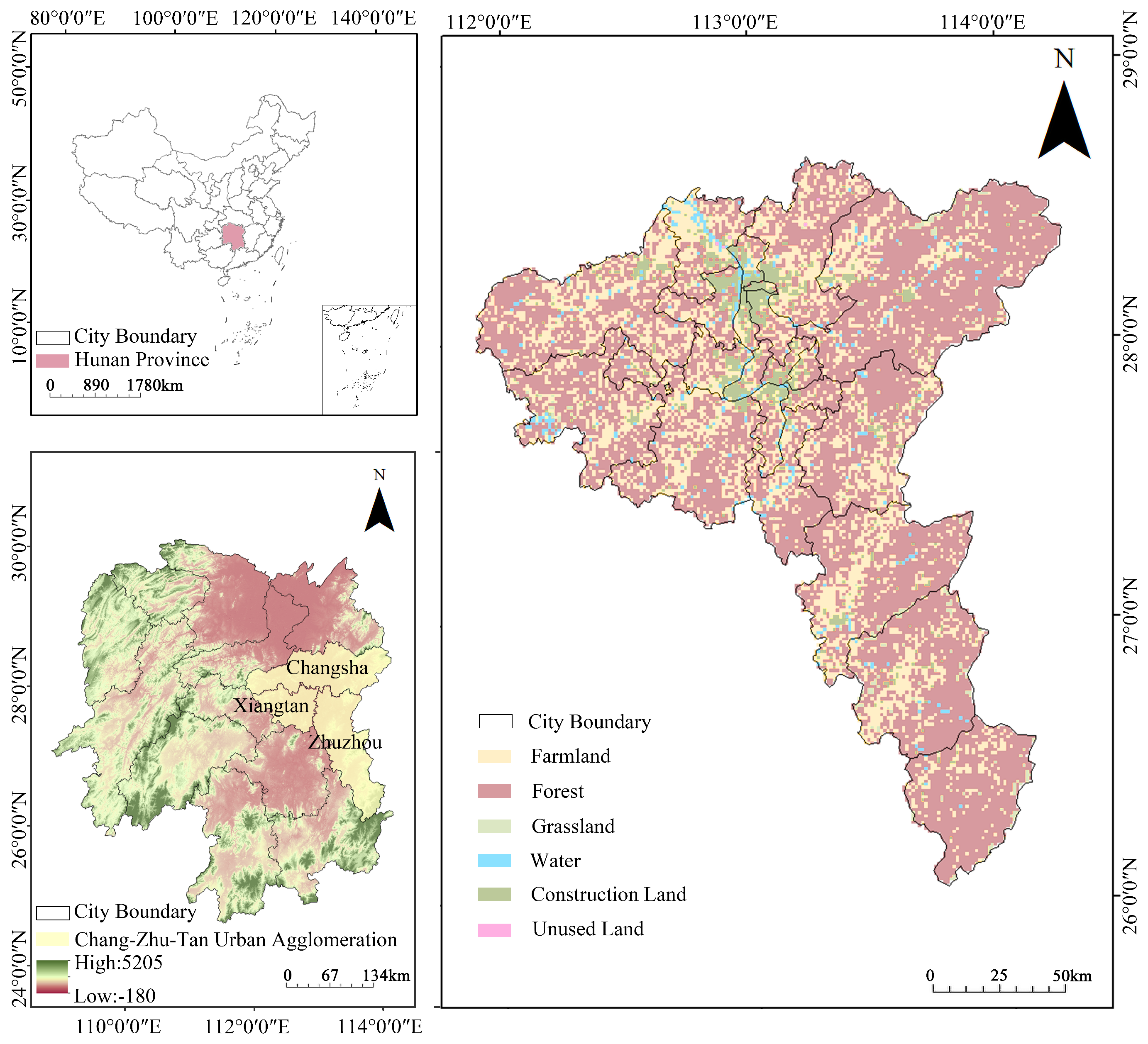
2.1. Study Area
2.2. Data Sources
3. Research Methodology
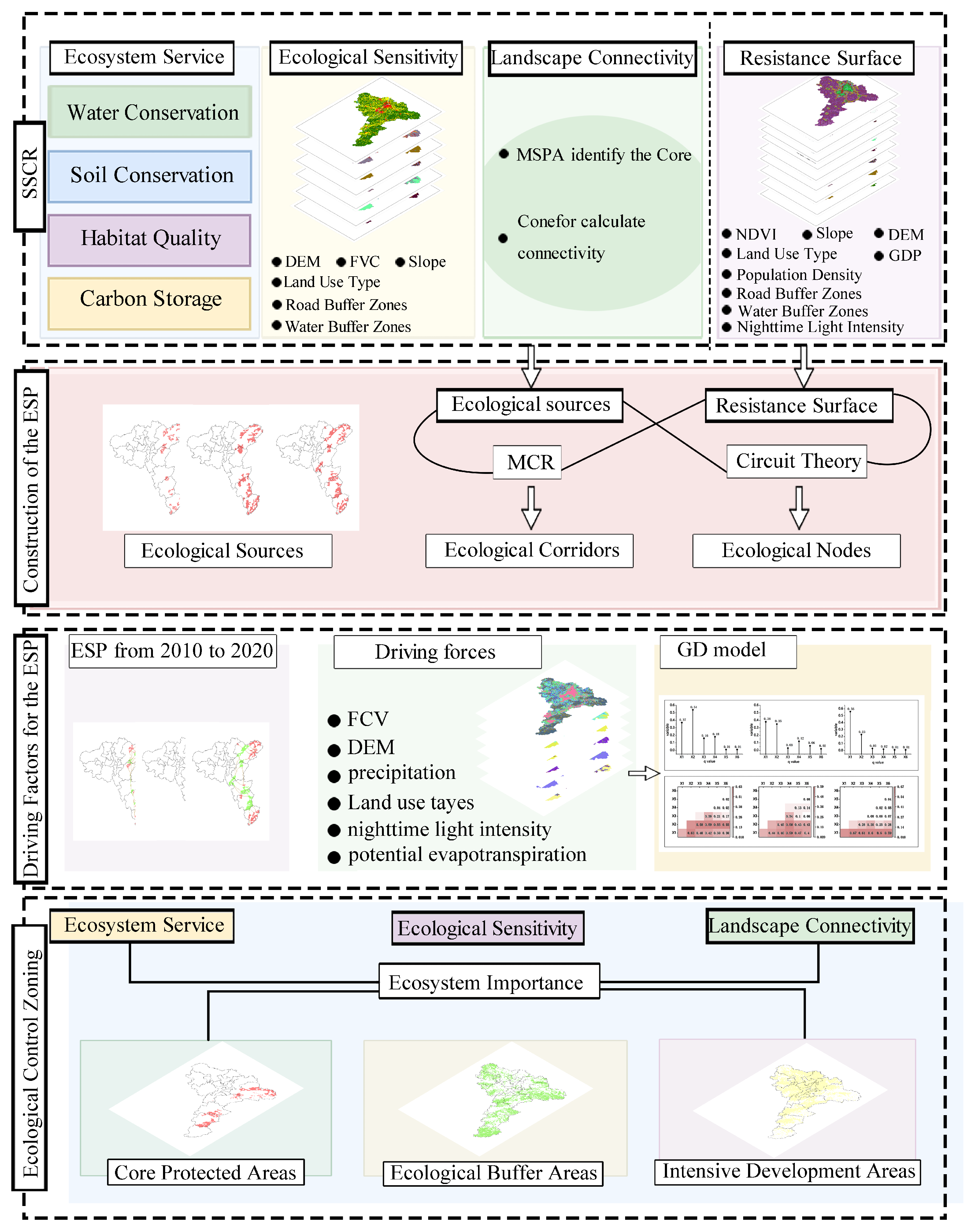
3.1. Construction of the ESP
3.1.1. Evaluation of Ecosystem Services
3.1.2. Evaluation of Ecological Sensitivity
3.1.3. Evaluation of Landscape Connectivity
3.1.4. Identification of Ecological Sources
3.1.5. Extraction of Ecological Corridors
3.1.6. Identification of Ecological Nodes
3.2. Analysis of Driving Factors for the ESP in the CZTUA
3.3. Delineation of Ecological Control Zones
4. Result
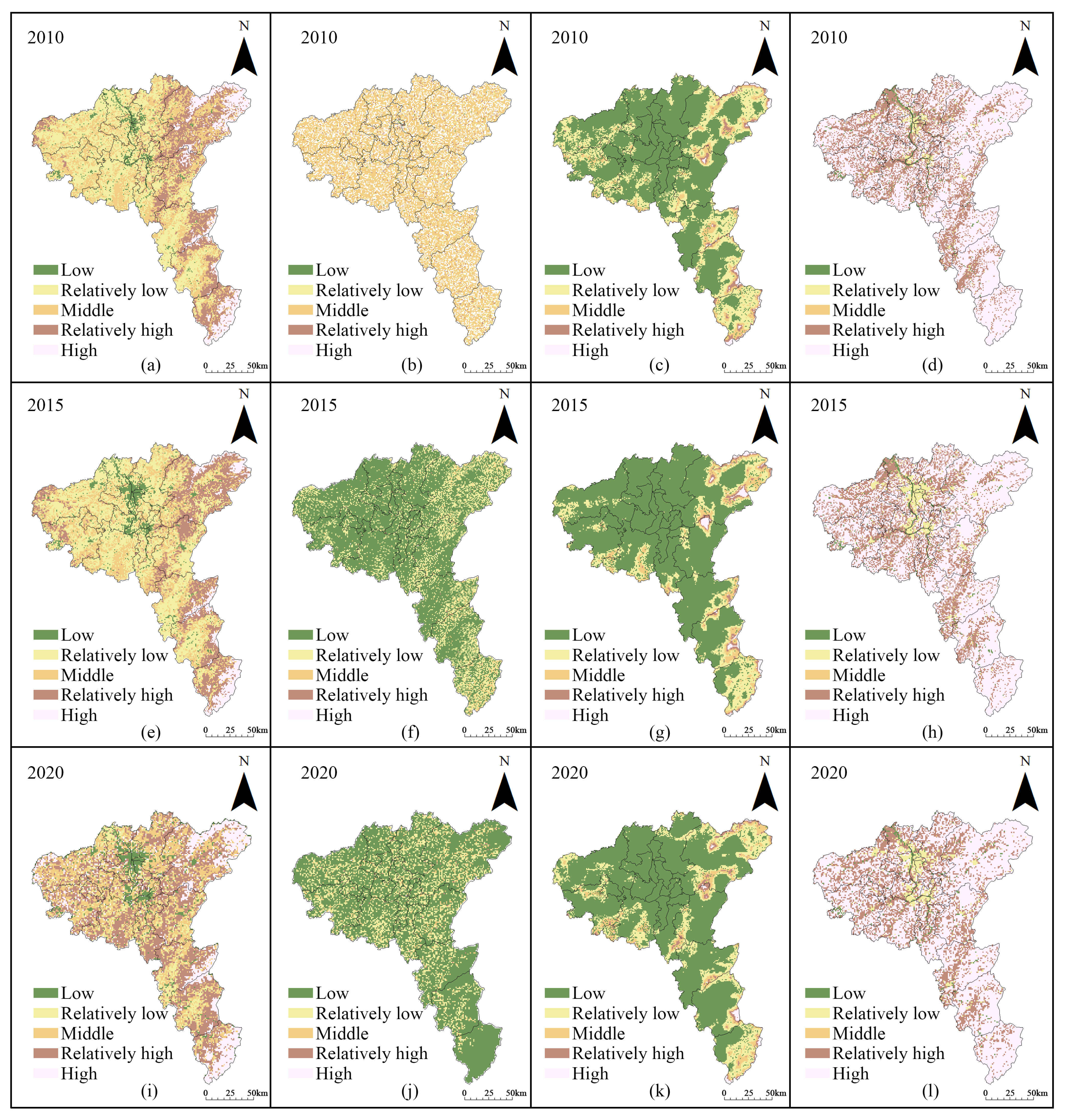
4.1. Ecosystem Service
4.2. Ecological Sensitivity
4.3. Landscape Connectivity
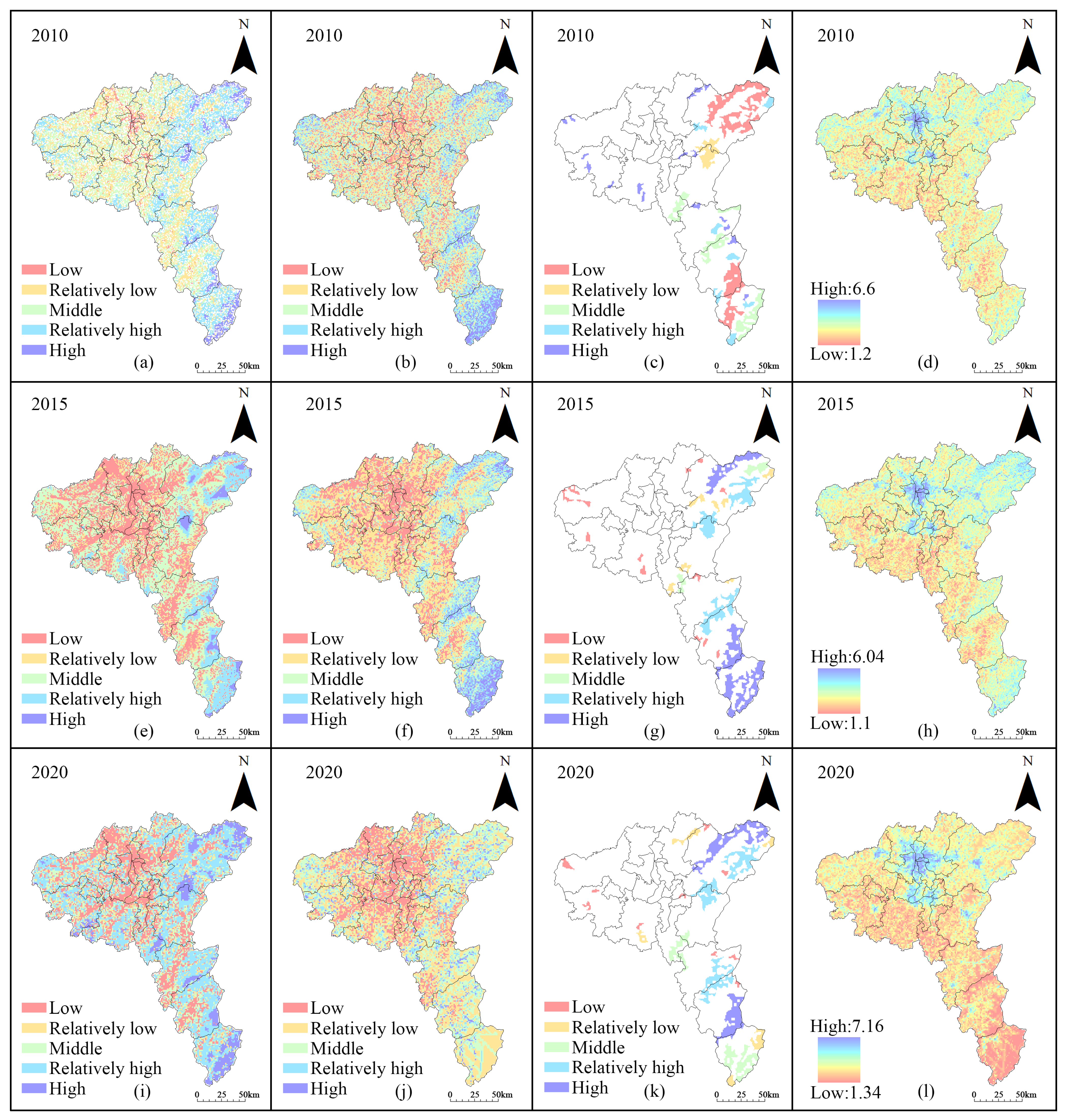
4.4. Ecosystem Importance and Ecological Sources
4.5. Comprehensive Resistance Surface and Ecological Corridors
4.6. Ecological Nodes
4.7. Driving Factor of ESP in the CZTUA
5. Discussion
5.1. Spatio-Temporal Evolution Characteristics of ESP in the CZTUA
5.2. Driving Forces for Spatio-Temporal Evolution of ESP in the CZTUA
5.3. Ecological Control Zoning and Improvement Strategies Based on ESP
5.3.1. Ecological Control Zoning
5.3.2. Improvement Strategies for Ecological Control Zoning
6. Conclusions
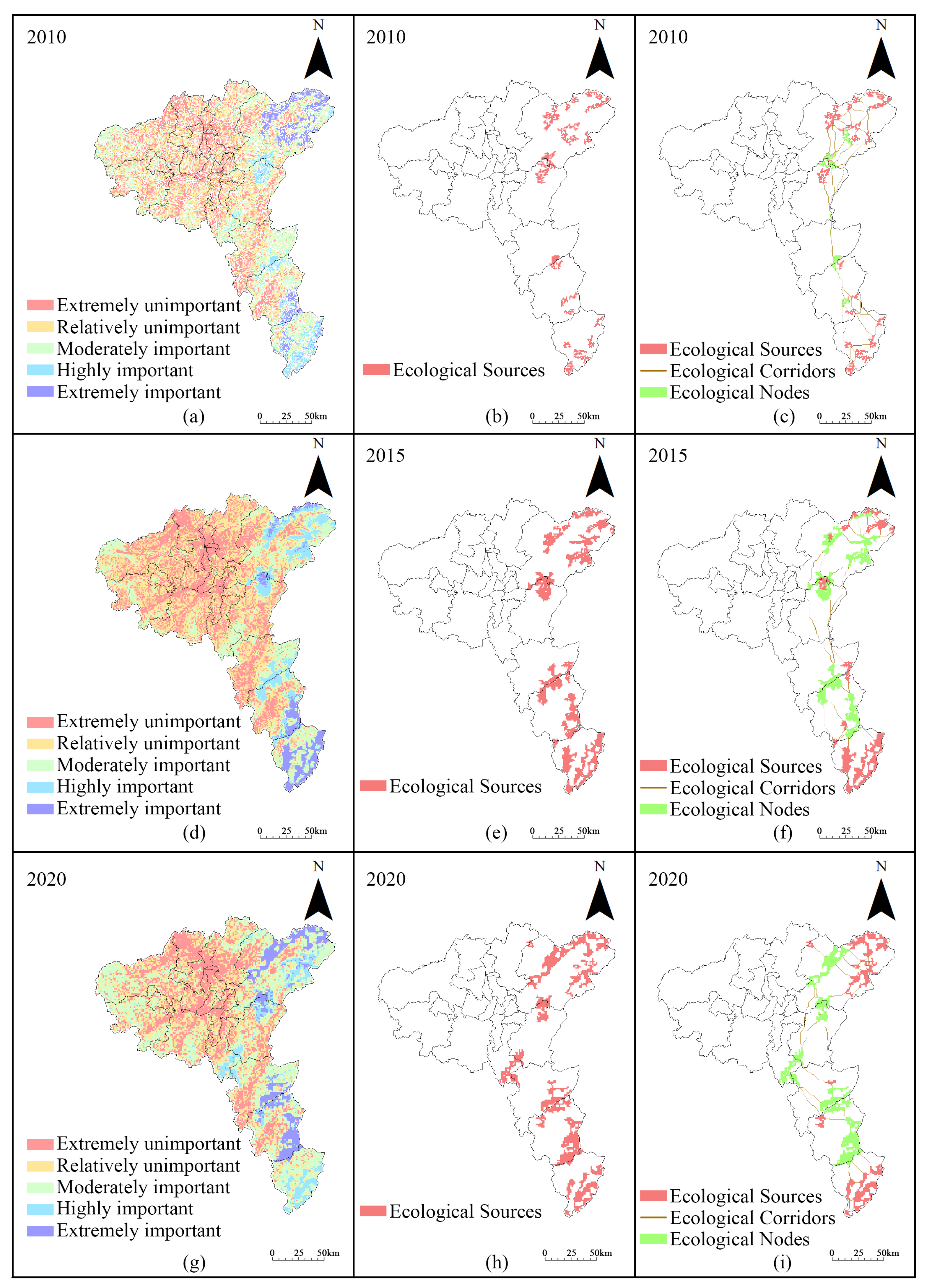
- Using the SSCR framework, the ESP of the CZTUA from 2010 to 2020 was constructed. The study identified 26, 23, and 23 ecological sources with areas of 1113.6 km2, 2791.07 km2, and 3013.96 km2, respectively. These sources showed a decrease in number but an increase in scale, following a “point-to-patch” developmental trend. Meanwhile, 52, 43, and 44 ecological corridors were identified, with total lengths of 1025.69 km, 684.40 km, and 536.25 km, respectively. This indicated a “decrease–increase”trend in quantity, though their total length consistently diminished. Additionally, 14, 10 and 5 ecological nodes were recognized, spanning areas of 290.6 km2, 1559 km2, and 1796.48 km2, respectively. Similar to ecological sources, nodes showed a reduction in number but an increase in scale over the study period.
- The spatial distribution of the ecological sources in the study area showed notable heterogeneity, with concentrations mainly in the eastern mountainous and hilly regions, while the sources expanded westward. The spatial patterns of ecological corridors and nodes were shaped by ecological sources. The density of ecological corridors changed with ecological sources, forming network-like distributions in dense areas and linear patterns in sparse regions. Similarly, the spatial positioning of ecological nodes shifted with ecological sources, gradually extending towards the western mountainous and hilly areas. The spatial distribution transitioned from the entry/exit areas of the ecological source to ecological corridors.
- The spatio-temporal evolution of the ESP in the CZTUA was significantly shaped by ecological sources, which was primarily driven by the dual-wheel mechanism of “natural foundation-policy regulation.” Among the natural environmental factors, the key drivers were precipitation and evapotranspiration, manifested through water conservation.
- This study demonstrated that the ESP of the CZTUA was significantly improved between 2010 and 2020. This structural optimization was driven by the dual mechanism of “natural foundation-policy regulation,” and its experience can serve as a valuable reference for ensuring ecological security in other rapidly urbanizing regions.
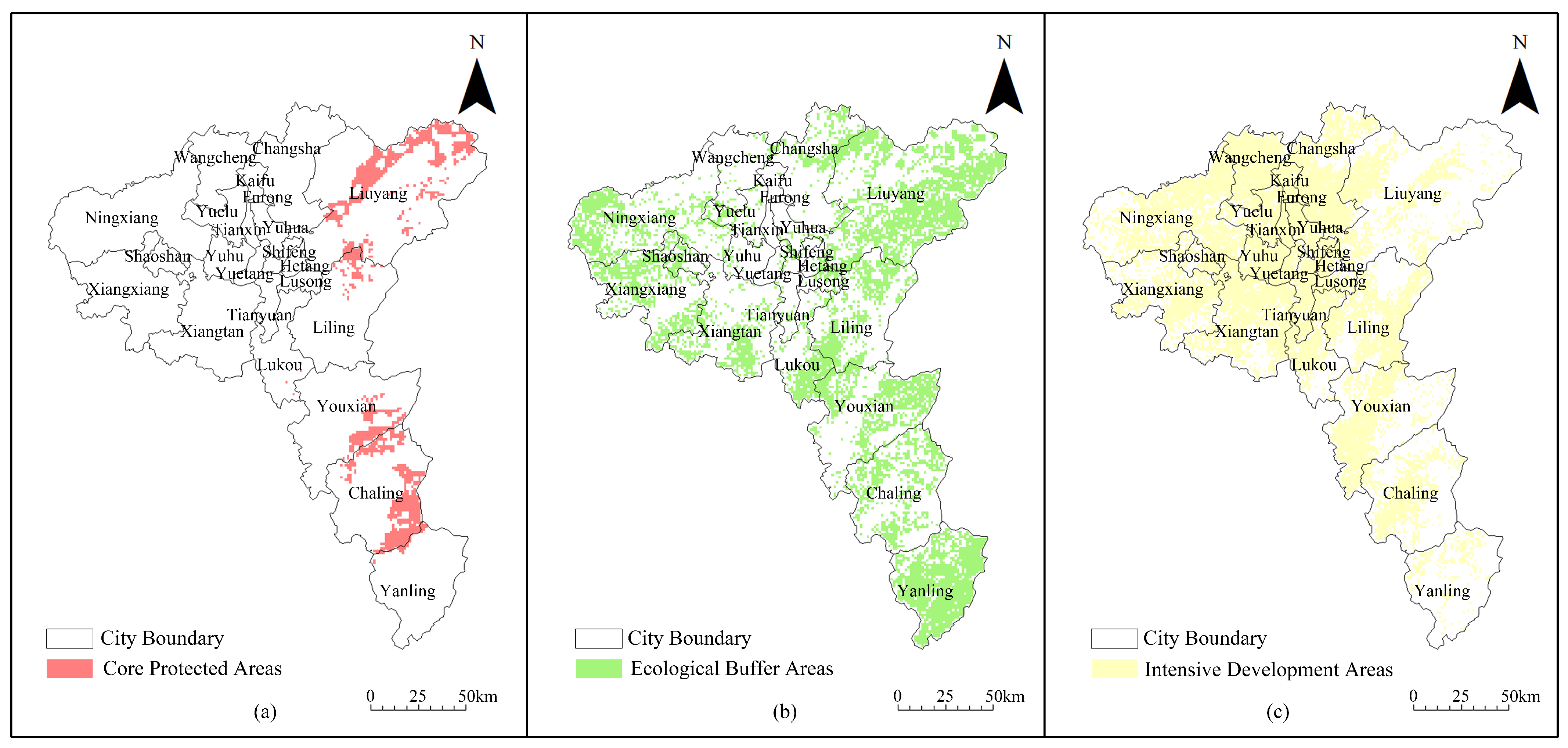
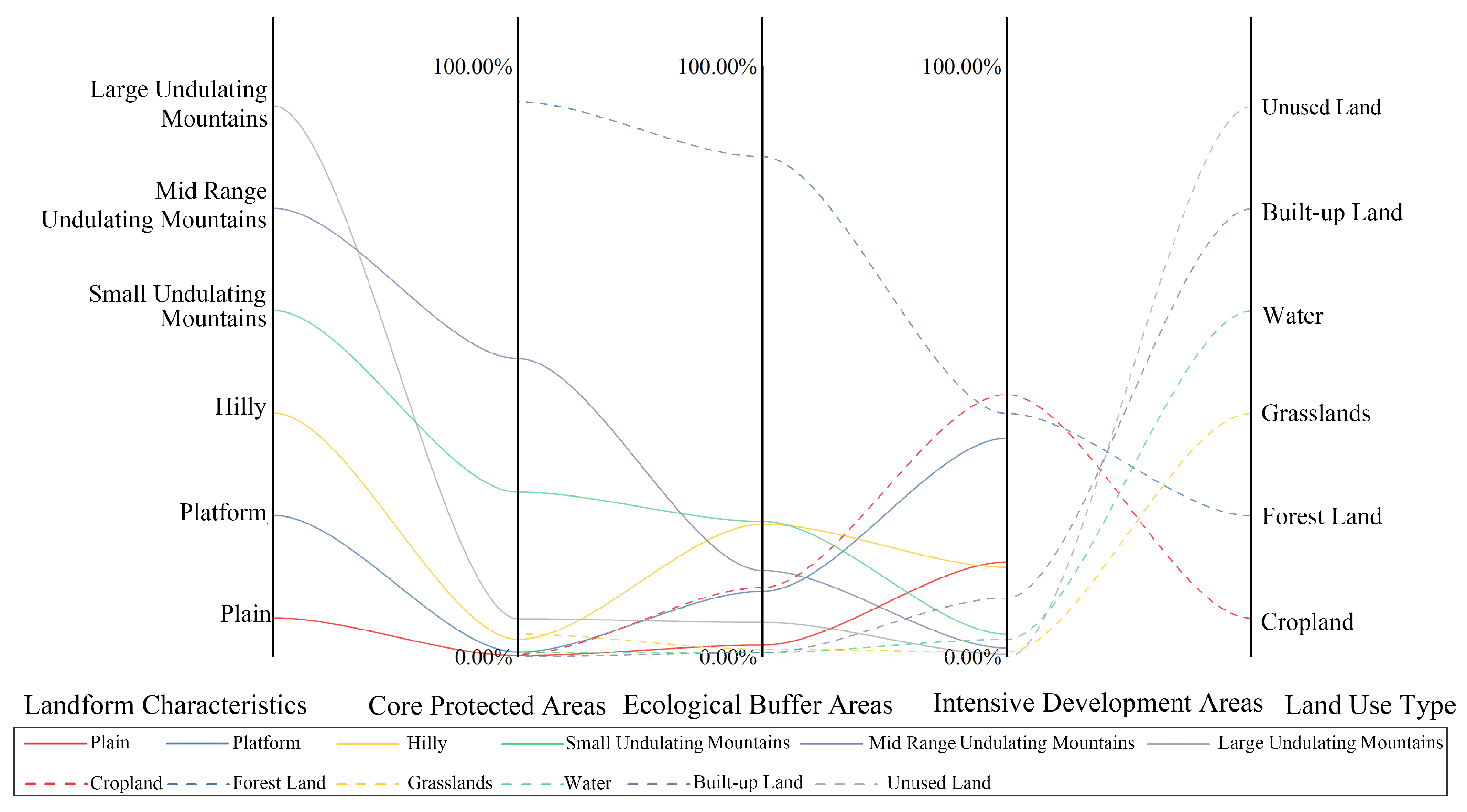
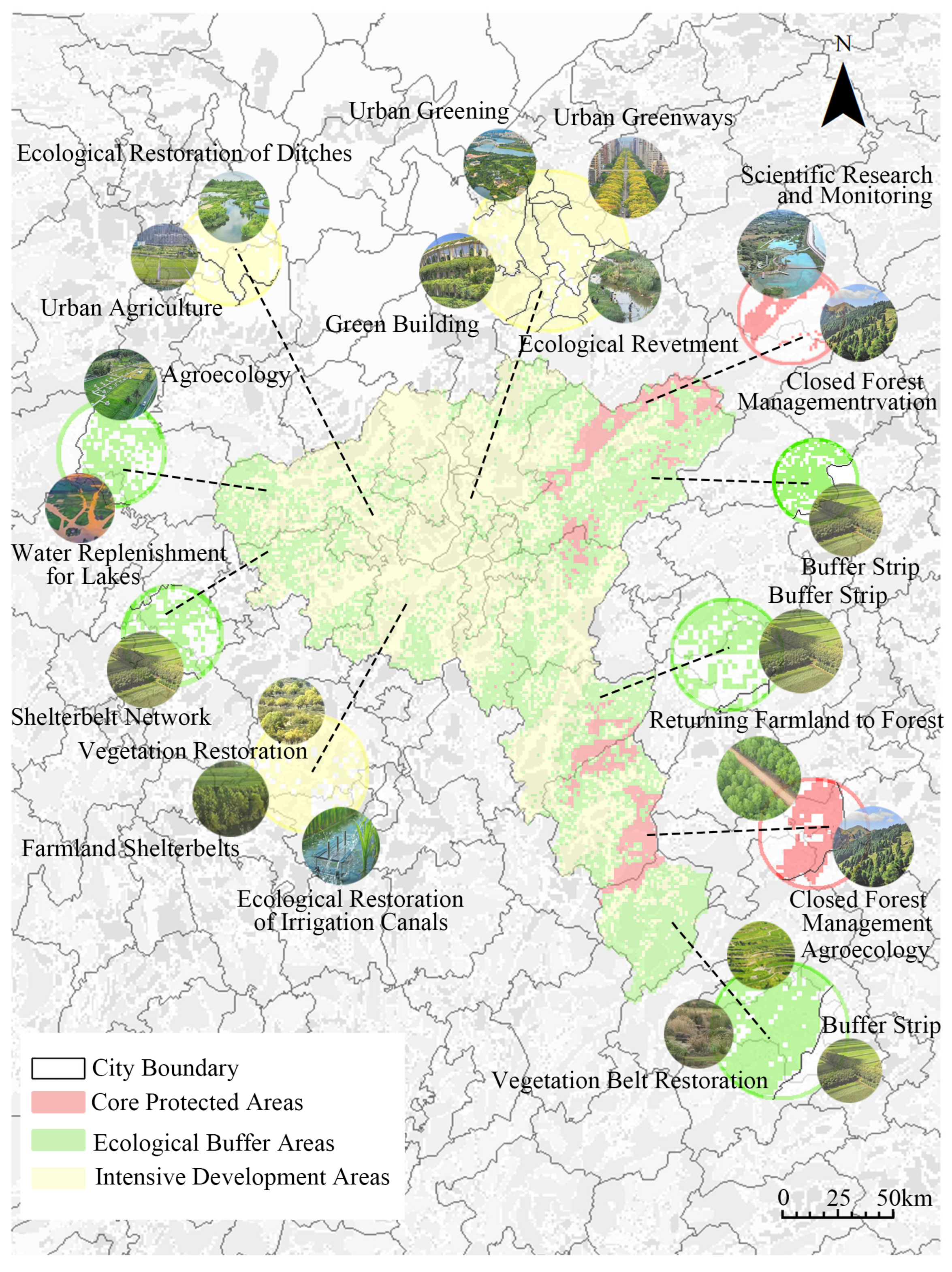
- The ecological control zoning results in the study area exhibit a spatial gradient pattern of “eastern mountainous ecological core–central hilly ecological buffer–western tableland plain development zone”. Differentiated spatial enhancement strategies were proposed accordingly: the core protection areas aim at ecological conservation, the buffer areas focus on ecological coordination, and the intensive development zones prioritize ecological optimization.
Author Contributions
Funding
Institutional Review Board Statement
Informed Consent Statement
Data Availability Statement
Conflicts of Interest
References
- Nazari, B.; Keshavarz, M. Water population density: Global and regional analysis. Theor. Appl. Climatol. 2023, 153, 431–445. [Google Scholar] [CrossRef]
- Chen, X.; Yang, Z.; Wang, T.; Han, F. Landscape Ecological Risk and Ecological Security Pattern Construction in World Natural Heritage Sites: A Case Study of Bayinbuluke, Xinjiang, China. ISPRS Int. J. Geo-Inf. 2022, 11, 328. [Google Scholar] [CrossRef]
- Fang, C.; Yu, D. Urban agglomeration: An evolving concept of an emerging phenomenon. Landsc. Urban Plan. 2017, 162, 126–136. [Google Scholar] [CrossRef]
- Liu, Y.; Lu, Y.; Xu, D.; Zhou, H.; Zhang, S. Enhancing the MSPA Method to Incorporate Ecological Sensitivity: Construction of Ecological Security Patterns in Harbin City. Sustainability 2024, 16, 2875. [Google Scholar] [CrossRef]
- Cao, W.; Li, X.; Lyu, X.; Dang, D.; Wang, K.; Li, M.; Liu, S. To explore the effectiveness of various ecological security pattern construction methods in many growth situations in the future: A case study of the West Liaohe River Basin in Inner Mongolia. Sci. Total Environ. 2024, 948, 174607. [Google Scholar] [CrossRef] [PubMed]
- Cao, C.; Luo, Y.; Xu, L.; Xi, Y.; Zhou, Y.C. Construction of ecological security pattern based onInVEST-Conefor-MCRM: A case study of Xinjiang, China. Ecol. Indic. 2024, 159, 111647. [Google Scholar] [CrossRef]
- Chen, W.; Zhao, J.; Chen, G.; Lin, Y.; Yang, H.; Chen, Q. Ecological Network Optimization andSecurity Pattern Development for Kunming’s Main Urban Area Using the MSPA-MCR Mode. Sustainability 2025, 17, 3623. [Google Scholar] [CrossRef]
- Zhang, R.; Hu, M.; Sheng, A.; Deng, W.; Zhang, S.; Liu, J. Construction of Ecological Security Network in Mountainous Transitional Geospace Using Circuit Theory and Morphological Spatial Pattern Analysis: A Case Study of Taihang Mountain Area. Sustainability 2025, 17, 1743. [Google Scholar] [CrossRef]
- Yan, M.; Duan, J.; Li, Y.; Yu, Y.; Wang, Y.; Zhang, J.; Qiu, Y. Construction of the Ecological Security Pattern in Xishuangbanna Tropical Rainforest Based on Circuit Theory. Sustainability 2024, 16, 3290. [Google Scholar] [CrossRef]
- Jin, X.; Wei, L.; Wang, Y.; Lu, Y. Construction of ecological security pattern based on the importance of ecosystem service functions and ecological sensitivity assessment: A case study in Fengxian County of Jiangsu Province, China. Environ. Dev. Sustain. 2021, 23, 563–590. [Google Scholar] [CrossRef]
- Wang, X.; Tang, X.; Shi, J.; Du, P. Construction and Optimization of Urban and Rural Ecological Security Patterns Based on Ecological Service Importance in a Semi-Arid Region: A Case Study of Lanzhou City. Sustainability 2024, 16, 6177. [Google Scholar] [CrossRef]
- Zhang, W.; Fan, Y.; Wang, B. Ecological Network Construction Based on Ecosystem Services and Landscape Pattern Indices in the Tabu River Basin. Land 2024, 13, 2209. [Google Scholar] [CrossRef]
- Li, Z.; Liu, J.; Ma, R.; Xie, W.; Zhao, X.; Wang, Z.; Zhang, B.; Yin, L. Construction of Ecological Security Pattern Based on Ecosystem Services, Sensitivity, Connectivity, and Resistance—A Case Study in the Huang-Huai-Hai Plain. Land 2024, 13, 2243. [Google Scholar] [CrossRef]
- Zhang, Q.; Sun, Y.; Tang, D.; Cheng, H.; Tu, Y. Construction and Zoning of Ecological Security Patterns in Yichang City. Sustainability 2025, 17, 2354. [Google Scholar] [CrossRef]
- Xu, A.; Hu, M.; Shi, J.; Bai, Q.; Li, X. Construction and optimization of ecological network in inland river basin based on circuit theory, complex network and ecological sensitivity: A case study of Gansu section of Heihe River Basin. Ecol. Model. 2024, 488, 110578. [Google Scholar] [CrossRef]
- Wu, T.; Lu, S.; Ding, Y. Ecological Security Evaluation System Integrated with Circuit Theory for Regional Ecological Security Pattern Construction: A Coordinated Study of Chang-Zhu-Tan Metropolitan Area in China. Land 2025, 14, 257. [Google Scholar] [CrossRef]
- Jia, D.; Qiu, W.; Guo, R.; Wu, M.; Wang, Z.; Hu, X. Prioritizing Protection and Restoration Areas Based on Ecological Security Pattern with Different Resistance Assignments. Land 2024, 14, 349. [Google Scholar] [CrossRef]
- Li, X.; Tao, H.; Wang, J.; Zhang, B.; Liu, Z.; Liu, Z.; Li, J. Integrated Evaluation of the Ecological Security Pattern in Central Beijing Using InVEST, MSPA, and Multifactor Indices. Land 2025, 14, 205. [Google Scholar] [CrossRef]
- Jiang, H.; Peng, J.; Liu, M.; Dong, J.; Ma, C. Integrating patch stability and network connectivity to optimize ecological security pattern. Landsc. Ecol. 2024, 39, 54. [Google Scholar] [CrossRef]
- Zhao, X.; Yue, Q.; Pei, J.; Pu, J.; Huang, P.; Wang, Q. Ecological Security Pattern Construction in Karst Area Based on Ant Algorithm. Int. J. Environ. Res. Public Health 2021, 18, 6863. [Google Scholar] [CrossRef]
- Belote, R.T.; Dietz, M.S.; McRae, B.H.; Theobald, D.M.; McClure, M.L.; Irwin, G.H.; McKinley, P.S.; Gage, J.A.; Aplet, G.H. Identifying Corridors among Large Protected Areas in the United States. PLoS ONE 2016, 11, e0154223. [Google Scholar] [CrossRef]
- Dickson, B.G.; Albano, C.M.; Anantharaman, R.; Beier, P.; Fargione, J.; Graves, T.A.; Gray, M.E.; Hall, K.R.; Lawler, J.J.; Leonard, P.B.; et al. Circuit-theory applications to connectivity science and conservation. Conserv. Biol. 2019, 33, 239–249. [Google Scholar] [CrossRef]
- Wang, C.; Yu, C.; Chen, T.; Feng, Z.; Hu, Y.; Wu, K. Can the establishment of ecological security patterns improve ecological protection? An example of Nanchang, China. Sci. Total Environ. 2020, 740, 140051. [Google Scholar] [CrossRef] [PubMed]
- Guo, R.; Wu, T.; Liu, M.; Huang, M.; Stendardo, L.; Zhang, Y. The Construction and Optimization of Ecological Security Pattern in the Harbin-Changchun Urban Agglomeration, China. Int. J. Environ. Res. Public Health 2019, 16, 1190. [Google Scholar] [CrossRef]
- Huang, Q.; Peng, B.; Elahi, E.; Wan, A. Evolution and driving mechanism of ecological security pattern: A case study of Yangtze River urban agglomeration. Integr. Environ. Assess. Manag. 2020, 17, 573–583. [Google Scholar] [CrossRef] [PubMed]
- Li, J.; Hu, D.; Wang, Y.; Chu, J.; Yin, H.; Ma, M. Study of identification and simulation of ecological zoning through integration of landscape ecological risk and ecosystem service value. Sustain. Cities Soc. 2024, 107, 105442. [Google Scholar] [CrossRef]
- Hu, Y.; Gong, J.; Li, X.; Song, L.; Zhang, Z.; Zhang, S.; Zhang, W.; Dong, J.; Dong, X. Ecological security assessment and ecological management zoning based on ecosystem services in the West Liao River Basin. Ecol. Eng. 2023, 192, 106973. [Google Scholar] [CrossRef]
- Guo, Z.; Hu, Y.; Bai, Y. How to achieve ecological control zoning based on ecological security pattern (ESP)? A case study of China’s coastal areas. Environ. Earth Sci. 2024, 83, 57. [Google Scholar] [CrossRef]
- Gao, H.; Liu, T.; Zhang, Y.; Zhang, P.; Zhang, X. FunctionZones and Hierarchical Protection of Qingshan Lake Provincial Scenic and Historic Area in Baishan City Based on Territorial Spatial Planning. Jilin For. Sci. Technol. 2025, 54, 25–28. [Google Scholar]
- Lei, J.; Yin, W.; Zhu, D. Research on ecological function regionalization based on the ecological service function-take Shenzhen River and Xinzhou River Estuarine Wetland for example. Adv. Mater. Res. 2015, 1073, 1171–1177. [Google Scholar] [CrossRef]
- Wu, X.; Deng, W.; Gao, X.; Zhao, Y. Research of control strategies about water ecology space based on national spatial planning: A case study of Chaohe River. Water Resour. Dev. Res. 2023, 23, 14–20. [Google Scholar]
- Wang, X.; Wen, D.; Liu, P.; Wei, C.; Zhao, P.; Xu, N. Maintaining ecological connectivity in highly urbanized areas: Optimal strategy, key patches and protection policy. Ecol. Indic. 2024, 164, 112152. [Google Scholar] [CrossRef]
- Zhang, W.; Jiang, Z.; Dai, H.; Lin, G.; Liu, K.; Yan, R.; Zhu, Y. Modelling Multi-Scenario Ecological Network Patterns and Dynamic Spatial Conservation Priorities in Mining Areas. Land 2024, 13, 1065. [Google Scholar] [CrossRef]
- Zhao, H.; Gu, B.; Zhang, Q.; Chen, Y. How Can the Balance of Green Infrastructure Supply and Demand Build an Ecological Security Pattern. Ecosyst. Health Sustain. 2024, 10, 0179. [Google Scholar] [CrossRef]
- Lacher, I.; Akre, T.; Mcshea, W.; Fergus, C. Spatial and temporal patterns of public and private land protection within the Blue Ridge and Piedmont ecoregions of the eastern US. Landsc. Urban Plan. 2019, 186, 91–102. [Google Scholar] [CrossRef]
- An, L.; Liu, G.; Hou, M. The Application of Geographic Information System in Urban Forest Ecological Compensation and Sustainable Development Evaluation. Forests 2024, 15, 285. [Google Scholar] [CrossRef]
- He, Y.; Lin, Y.; Zhou, G.; Zhu, Y.; Tang, K. Spatial pattern and drivers of urbanization in China’s mid-level developing urban agglomeration: A case study of Chang-Zhu-Tan. Reg. Sustain. 2021, 2, 83–97. [Google Scholar] [CrossRef]
- Zhu, Z.; He, Q. Spatio-temporal evaluation of the urban agglomeration expansion in the middle reaches of the Yangtze River and its impact on ecological lands. Sci. Total Environ. 2021, 790, 148150. [Google Scholar]
- Fang, Z.; Ding, T.; Chen, J.; Xue, S.; Zhou, Q.; Wang, Y.; Wang, Y.; Huang, Z.; Yang, S. Impacts of land use/land cover changes on ecosystem services in ecologically fragile regions. Sci. Total Environ. 2022, 831, 154967. [Google Scholar] [CrossRef]
- Li, W.; Geng, J.; Bao, J.; Lin, W.; Wu, Z.; Fan, S. Analysis of Spatial and Temporal Variations in Ecosystem Service Functions and Drivers in Anxi County Based on the InVEST Model. Sustainability 2023, 15, 10153. [Google Scholar] [CrossRef]
- Cong, W.; Sun, X.; Guo, H.; Shan, R. Comparison of the SWAT and InVEST models to determine hydrological ecosystem service spatial patterns, priorities and trade-offs in a complex basin. Ecol. Indic. 2020, 112, 106089. [Google Scholar] [CrossRef]
- Li, Z.; Xu, J.; Yuan, Z.; Wang, L. Integrated Ecological Security Assessment: Coupling Risk, Health, and Ecosystem Services in Headwater Regions—A Case Study of the Yangtze and Yellow River Source. Water 2025, 17, 2834. [Google Scholar] [CrossRef]
- Yuan, Q.; Li, R. The negative impacts of human activities on the ecological corridor in the karst highly urbanized area are gradually diminishing: A case study from the karst mountain cities in Southwest China. Ecol. Indic. 2023, 157, 111257. [Google Scholar] [CrossRef]
- Liu, X.; Su, Y.; Li, Z.; Zhang, S. Constructing ecological security patterns based on ecosystem services trade-offs and ecological sensitivity: A case study of Shenzhen metropolitan area, China. Ecol. Indic. 2023, 154, 110626. [Google Scholar] [CrossRef]
- Gu, T.; Tong, Y.; Wang, S.; You, Z.; Li, D.; Jiang, Y.; Rafaqat, A.; Wang, C.; Zhang, Q. Identifying the priority areas for ecological protection considering ecological connectivity and ecosystem integrity: A case study of Xianyang City, China. Ecol. Indic. 2024, 163, 112102. [Google Scholar] [CrossRef]
- Li, H.; Zhang, T.; Cao, X.; Zhang, Q. Establishing and Optimizing the Ecological Security Pattern in Shaanxi Province (China) for Ecological Restoration of Land Space. Forests 2022, 13, 766. [Google Scholar] [CrossRef]
- Wang, F.; Yuan, X.; Zhou, L.; Zhang, M. Integrating ecosystem services and landscape connectivity to construct and optimize ecological security patterns: A case study in the central urban area Chongqing municipality, China. Environ. Sci. Pollut. Res. 2022, 29, 43138–43154. [Google Scholar] [CrossRef]
- Vogt, P.; Ferrari, J.R.; Lookingbill, T.R.; Gardner, R.H.; Riitters, K.H.; Ostapowicz, K. Mapping functional connectivity. Ecol. Indic. 2009, 9, 64–71. [Google Scholar] [CrossRef]
- Zhang, H.; Li, J.; Tian, P.; Pu, R.; Cao, L. Designing Ecological Security Patterns Based on the Framework of Ecological Quality and Ecologica. J. Geogr. Sci. 2022, 32, 663–681. [Google Scholar] [CrossRef]
- Haddad, N.M.; Brudvig, L.A.; Clobert, J.; Davies, K.F.; Gonzalez, A.; Holt, R.D.; Lovejoy, T.E.; Sexton, J.O.; Austin, M.P.; Collins, C.D.; et al. Habitat fragmentation and its lasting impact on Earth’s ecosystems. Int. J. Environ. Res. Public Health 2015, 1, e150052. [Google Scholar] [CrossRef] [PubMed]
- Collins Cathy, D.; Holt Robert, D.; Foster Bryan, L. Patch size effects on plant species decline in an experimentally fragmented landscape. Ecology 2009, 90, 2577–2588. [Google Scholar] [CrossRef]
- Huang, L.; Xiang, F.; Chen, R. Identification of key areas for ecological protection and restoration of county territorial space based on ecological security pattern: A case study in Yihuang County of Fuzhou City. J. Environ. Eng. Technol. 2023, 13, 1334–1344. [Google Scholar]
- Zhang, F.; Jia, Y.; Liu, X.; Li, T.; Gao, Q. Application of MSPA-MCR models to construct ecological security pattern in the basin: A case study of Dawen River basin. Ecol. Indic. 2024, 160, 111887. [Google Scholar] [CrossRef]
- Ye, Y.; Su, Y.; Zhang, H.o.; Liu, K.; Wu, Q. Construction of an ecological resistance surface model and its application in urban expansion simulations. J. Geogr. Sci. 2015, 25, 211–224. [Google Scholar] [CrossRef]
- Lin, J.; Yang, W.; Yu, K.; Geng, J.; Liu, J. Identification and Construction of Ecological Nodes in the Fuzhou Ecological Corridors. Forests 2022, 13, 1837. [Google Scholar] [CrossRef]
- Yu, H.; Gu, X.; Liu, G.; Fan, X.; Zhao, Q.; Zhang, Q. Construction of Regional Ecological Security Patterns Based on Multi-Criteria Decision Making and Circuit Theory. Remote Sens. 2022, 14, 527. [Google Scholar] [CrossRef]
- Tang, L.; Liang, G.; Gu, G.; Xu, J.; Duan, L.; Zhang, X.; Yang, X.; Lu, R. Study on the spatial-temporal evolution characteristics, patterns, and driving mechanisms of ecological environment of the Ecological Security Barriers on China’s Land Borders. Environ. Impact Assess. Rev. 2023, 103, 107267. [Google Scholar] [CrossRef]
- Huang, X.; Peng, S.Y.; Wang, Z.; Huang, B.M.; Liu, J. Spatial heterogeneity and driving factors of ecosystem water yield service in Yunnan Province, China based on Geodetector. J. Appl. Ecol. 2022, 33, 2813–2821. [Google Scholar]
- Xiao, S.; Wu, W.; Guo, J.; Ou, M.; Pueppke, S.G.; Ou, W.; Tao, Y. An evaluation framework for designing ecological security patterns and prioritizing ecological corridors: Application in Jiangsu Province, China. Landsc. Ecol. 2020, 35, 2517–2534. [Google Scholar] [CrossRef]
- Zhang, S.; Chen, Y.; Li, J.; Ye, Q.; Chen, W.; Wang, X.; Wei, H.; Jiang, Q.; Guo, L. A spatiotemporal analysis framework of the ecological security pattern based on the ecological “source–surface–corridor” and its implications. Front. Ecol. Evol. 2024, 12, 1480198. [Google Scholar] [CrossRef]
- Yang, Y.; Chen, J.; Huang, R.; Feng, Z.; Zhou, G.; You, H.; Han, X. Construction of Ecological Security Pattern Based on the Importance of Ecological Protection—A Case Study of Guangxi, a Karst Region in China. Int. J. Environ. Res. Public Health 2022, 19, 5699. [Google Scholar] [CrossRef]
- McRae, B.H.; Dickson, B.G.; Keitt, T.H.; Shah, V.B. Using circuit theory to model connectivity in ecology, evolution, and conservation. Ecology 2008, 89, 2712–2724. [Google Scholar] [CrossRef]
- Li, K.; Qian, H.; Li, S.; Cao, Z.; Tian, P.; Shi, X.; Chen, J.; Gao, Y. Quantifying the Driving Forces of Water Conservation Using Geodetector with Optimized Parameters: A Case Study of the Yiluo River Basin. Land 2025, 14, 274. [Google Scholar] [CrossRef]
- Zhao, G.; Tian, S.; Liang, S.; Jing, Y.; Chen, R.; Wang, W.; Han, B. Dynamic evolution trend and driving mechanisms of water conservation in the Yellow River Basin, China. Sci. Rep. 2024, 14, 26304. [Google Scholar] [CrossRef] [PubMed]
- Zhang, J.; Qu, J.; Chen, H.; Shi, J.; Ma, Y.; Liu, D. Spatial and temporal evolution and influencing factors of ecological security pattern based on circuit theory: A case of Loess Plateau in northern Shaanxi. Arid Land Geogr. 2025, 48, 494. [Google Scholar]


| Data Type | Resolution | Data Sources | Access Time |
|---|---|---|---|
| Land use data | 1 km | Resource and Environmental Science Data Platform (resdc.cn) https://www.resdc.cn | Accessed on 15 July 2024 |
| Annual precipitation data | 1 km | National Earth System Science Data Center (geodata.cn) https://www.geodata.cn | Accessed on 29 July 2024 |
| Monthly potential evapotranspiration data | 1 km | National Earth System Science Data Center (geodata.cn) https://www.geodata.cn | Accessed on 28 July 2024 |
| DEM | 30 m | Geospatial Data Cloud (gscloud.cn) https://www.gscloud.cn | Accessed on 22 July 2024 |
| Population Density | 1 km | Earth Resources Data Cloud (gis5g.com) http://www.gis5g.com/data/rksj?id=1562 | Accessed on 27 July 2024 |
| NDVI | 1 km | Earth Resources Data Cloud (gis5g.com) | Accessed on 26 July 2024 |
| Nighttime Light Intensity | 1 km | Earth Resources Data Cloud (gis5g.com) http://www.gis5g.com/data/dgsj | Accessed on 26 July 2024 |
| Spatial distribution of landform types across the country | 1 km | Data Box (database-store.com) https://www.databox.store/DownLoad/Details/24 | Accessed on 3 January 2025 |
| Types | Formula |
|---|---|
| Water Conservation (WC) | where is the WC of the grid j, is the annual water yield, is the surface runoff, is the average annual precipitation, and is the average annual potential evapotranspiration. |
| Soil Conservation (SC) | where SC is the soil conservation, R is the rainfall erosivity factor, K is the soil erosion factor, is slope length and slope factor, C is the plant cover factor, and P is soil and water conservation factor. |
| Habitat Quality (HQ) | where is the annual CS capacity of the land grid x of type j, , , , and are soil organic carbon, aboveground organic carbon, underground organic carbon, and dead organic carbon densities of type j land. |
| Carbon Storage (CS) | where is the HQ of j habitat types, is the degree of habitat degradation of x habitat types, is the suitability of habitat type j, k is the semi-saturation coefficient, and Z is the normalization constant. |
| Factors | 2010 | 2015 | 2020 |
|---|---|---|---|
| Road Buffer Zones | 0.26 | 0.27 | 0.31 |
| Water Buffer Zones | 0.15 | 0.13 | 0.15 |
| Land Use Types | 0.06 | 0.07 | 0.07 |
| FVC | 0.10 | 0.08 | 0.09 |
| Slope | 0.18 | 0.22 | 0.21 |
| DEM | 0.25 | 0.23 | 0.17 |
| Indicators | 2010 | 2015 | 2020 |
|---|---|---|---|
| DEM | 0.16 | 0.13 | 0.09 |
| Slope | 0.10 | 0.13 | 0.12 |
| NDVI | 0.05 | 0.05 | 0.09 |
| Population Density | 0.09 | 0.09 | 0.08 |
| GDP | 0.07 | 0.09 | 0.09 |
| Nighttime Light Intensity | 0.14 | 0.13 | 0.15 |
| Land Use Types | 0.14 | 0.14 | 0.13 |
| Road Buffer Zones | 0.15 | 0.16 | 0.17 |
| Water Buffer Zones | 0.10 | 0.08 | 0.08 |
| Indicators | 2010 | 2015 | 2020 |
|---|---|---|---|
| Core | 5303 | 5211.36 | 5397 |
| Islet | 308 | 395.5 | 473 |
| Perforation | 212 | 179.48 | 286 |
| Edge | 2744 | 2886.72 | 2734 |
| Bridge | 5482 | 4997.49 | 5262 |
| Loop | 132 | 145.09 | 163 |
| Branch | 1751 | 1853.9 | 1824 |
Disclaimer/Publisher’s Note: The statements, opinions and data contained in all publications are solely those of the individual author(s) and contributor(s) and not of MDPI and/or the editor(s). MDPI and/or the editor(s) disclaim responsibility for any injury to people or property resulting from any ideas, methods, instructions or products referred to in the content. |
© 2025 by the authors. Licensee MDPI, Basel, Switzerland. This article is an open access article distributed under the terms and conditions of the Creative Commons Attribution (CC BY) license (https://creativecommons.org/licenses/by/4.0/).
Share and Cite
Liao, J.; Jia, H.; Liang, Y.; Liu, W.; Xia, Y.; Chen, S.; Pi, H. Ecological Control Zoning and Improvement Strategy Based on Ecological Security Pattern in Changsha–Zhuzhou–Xiangtan Urban Agglomeration. Sustainability 2025, 17, 10444. https://doi.org/10.3390/su172310444
Liao J, Jia H, Liang Y, Liu W, Xia Y, Chen S, Pi H. Ecological Control Zoning and Improvement Strategy Based on Ecological Security Pattern in Changsha–Zhuzhou–Xiangtan Urban Agglomeration. Sustainability. 2025; 17(23):10444. https://doi.org/10.3390/su172310444
Chicago/Turabian StyleLiao, Jianyu, Huiru Jia, Yarui Liang, Wanting Liu, Yurui Xia, Shan Chen, and Hejie Pi. 2025. "Ecological Control Zoning and Improvement Strategy Based on Ecological Security Pattern in Changsha–Zhuzhou–Xiangtan Urban Agglomeration" Sustainability 17, no. 23: 10444. https://doi.org/10.3390/su172310444
APA StyleLiao, J., Jia, H., Liang, Y., Liu, W., Xia, Y., Chen, S., & Pi, H. (2025). Ecological Control Zoning and Improvement Strategy Based on Ecological Security Pattern in Changsha–Zhuzhou–Xiangtan Urban Agglomeration. Sustainability, 17(23), 10444. https://doi.org/10.3390/su172310444


