Article

The Impacts of Severe Drought on Waterbirds: A Case Study for the White-Naped Crane in Poyang Lake Based on Satellite Telemetry

1
School of Ecology and Nature Conservation, Beijing Forestry University, Beijing 100083, China
2
Poyang Lake National Nature Reserve, Nanchang 330038, China
3
State Key Laboratory of Animal Biodiversity Conservation and Integrated Pest Management, Institute of Zoology, Chinese Academy of Sciences, Beijing 100101, China
4
University of Chinese Academy of Sciences, Beijing 100049, China
*
Author to whom correspondence should be addressed.
Sustainability 2025, 17(23), 10429; https://doi.org/10.3390/su172310429
Submission received: 20 September 2025 / Revised: 14 November 2025 / Accepted: 17 November 2025 / Published: 21 November 2025

Abstract

Climate change is leading to more extreme weather like droughts, threatening wetland ecosystem and waterbird populations worldwide. During the winter of 2022–2023, Poyang Lake, China’s largest freshwater lake, experienced its most extreme drought on record. However, the impacts of such droughts on waterbirds remain poorly understood. To assess the ecological consequences on waterbirds, we studied on the White-naped Crane (Antigone vipio). Using GPS transmitters, we tracked 56 individuals and collected 268,615 valid hourly location records from the Poyang Lake region between 2014 and 2023. We analyzed movement patterns during this extreme drought compared to typical winter conditions. The results indicate that, in winter at Poyang Lake, the White-naped Cranes primarily utilized croplands for foraging and shallow water areas for roosting. We found that habitat suitability for White-naped Cranes reached its lowest point during this exceptionally dry winter. Reduced water levels forced the cranes to move much further to seek alternative habitats, especially shallow water areas for nocturnal roosting. These findings underscore that maintaining adequate water level to protect both roosting and foraging habitats at Poyang Lake is a critical conservation priority for sustaining waterbird populations under intensifying climatic extremes.

1. Introduction

Drought is a pressing concern that exemplifies the profound influence of global warming on our planet’s water resources [1]. As temperatures rise and weather patterns become increasingly unpredictable, the frequency, intensity, and duration of drought events are projected to escalate [2,3,4], although some researchers have questioned these predictions [5,6]. The Intergovernmental Panel on Climate Change (IPCC) emphasized in its Sixth Assessment Report that human-induced climate change has contributed to the amplification of extreme weather such as drought in many regions [7], and the severity of droughts has increased at the global scale [8], threatening the sustainability of associated ecosystem and species.
Waterbirds are particularly vulnerable to droughts because they rely on wetlands for food, shelter, and stopover sites during migration. When wetlands dry up, waterbirds are forced to move elsewhere in search of food and water (e.g., [9]). In California, annual abundance of shorebirds dropped 22% during periods of 3-year drought (2013–2015) compared to non-drought years [10]. In Botswana, bird numbers decreased during the drought by 37–81% and species by 8–52% compared to the wet season [11]. In Romania, after a partial drying in 2013 and a total drying in 2020 of the Nuntași and Tuzla lakes, pelicans and swans left the area [12]. In the United States, the whooping cranes (Grus americana) experience higher winter mortality during drought periods, because winter drought caused increased salinity levels and reduced freshwater in the bays and saltmarshes, which have direct or indirect effects on the availability of resources (i.e., food and freshwater) and behavioral responses (i.e., movement) of whooping cranes [13]. In China, drought is also one reason for the decrease in some waterbirds [14]. These examples demonstrate the vulnerability of local water bird populations to drought and emphasize the urgent need for conservation efforts and adaptive management strategies to mitigate the impacts. Protecting and restoring wetland habitats, maintaining water sources, and implementing sustainable water management practices are crucial to protecting water bird populations against increasingly frequent and severe droughts.
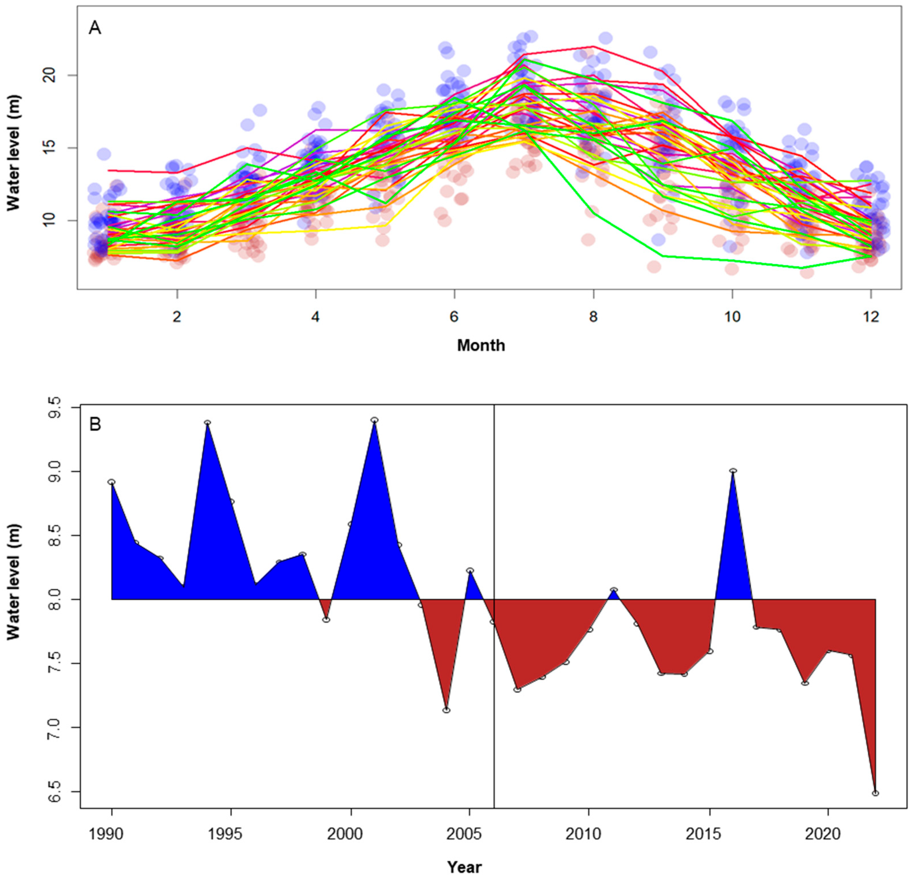
In recent years, China had more frequent and severe extreme climate conditions than in previous decades [15]. In 2004, Poyang Lake experienced a severe drought, the water level at Xingzi Station dropped to 7.11 m, and the water area shrank from around 4000 km2 to below 200 km2—the least it had been in 60 years; in 2007, 2012–2015, and 2019, the water levels of Poyang Lake were also very low (Figure 1). In 2022, the severest drought struck the Lower Yangtze River Basin, including Poyang Lake. On 9 November 2022, the water level at Xingzi Station plummeted to 6.67 m, breaking the previous historical record [15]. The winter of late 2022 and early 2023 proved to be the driest season ever witnessed at Poyang Lake. This extreme drought changed waterfowl distribution patterns, altered the distribution and behavior of the wintering Oriental Storks (Ciconia boyciana), Greater White-fronted Goose (Anser albifrons), Bean Goose (Anser fabalis), Swan Goose (Anser cygnoid), and the Siberian Crane (Leucogeranus leucogeranus) [16] at Poyang Lake. The impact of the drought on White-naped Crane (Antigone vipio) is unknown.
Satellite telemetry has become a powerful tool for monitoring the status of waterbirds. Twenty years ago, foundational insights into the migratory patterns of the White-naped Crane were established by tracking 11 individuals in East Asia [17]. More recently, satellite tracking has been employed in the Poyang Lake and Yangtze River floodplains to study several species, including the Greater White-fronted Goose and the Tundra Bean Goose [18], the Swan Goose [19], and the Oriental White Stork (Ciconia boyciana) [20]. This approach has significantly enhanced our understanding of these species’ movements and behaviors, providing critical data for their conservation.
From 2014 to 2023, we used satellite telemetry to track the movements of 78 White-naped Cranes, with 56 individuals overwintering at Poyang Lake. Our hypotheses are: (1) Severe drought alters wetland hydrology at Poyang Lake, leading to reduced availability and quality of roosting and foraging habitats, which in turn causes significant changes in the space-use patterns and habitat selection of overwintering White-naped Cranes; (2) Species distribution models parameterized with telemetry data will effectively capture the environmental drivers of crane habitat use and reveal a contraction or shift in suitable habitat during drought years compared to normal hydrological conditions. Additionally, we aim to provide recommendations on whether to construct a dam to promote biodiversity conservation and economic development. Our findings aim to inform strategies and policies aimed at preserving and restoring wetlands, ensuring their long-term sustainability and resilience in the face of climate change challenges.

2. Materials and Methods

2.1. Study Area

Poyang Lake, with a maximum area of 4000 km2, is the largest freshwater lake in China (Figure 1). It is one of only two remaining lakes in China with a natural annual flooding cycle, which sustains productive wetlands essential for waterbird populations. In contrast, most other lakes have been enclosed by levees, resulting in deeper water conditions that are unsuitable for many waterbird species. Poyang Lake holds great significance as the primary wintering ground for the White-naped Crane, the Siberian Crane (Leucogeranus leucogeranus), and hundreds of thousands of other waterbirds [21]. In 1983, Poyang Lake Nature Reserve was established; in 1992, Poyang Lake was designated as one of China’s inaugural Wetlands of International Importance (also known as a Ramsar site) [21].
Poyang Lake maintains a near—natural state with seasonal flood in summer (Figure 2), and water level fluctuations create suitable habitats for migratory waterbirds during wintertime [21,22,23], becoming the most important wintering area for endangered birds like the Siberian Crane [24,25], the White-naped Crane and many geese and ducks [26].

2.2. Study Species

The White-naped Crane is a large, migratory bird species native to East Asia. These cranes breed primarily in southern Siberia, northern Mongolia, and parts of northeastern China, and migrate to wintering grounds in China, Korea, and Japan [17,27]. They rely heavily on wetlands, floodplains, and agricultural fields for feeding and roosting, making them highly sensitive to habitat loss and environmental changes such as droughts and wetland degradation [28,29]. Listed as Vulnerable by the IUCN, White-naped Cranes face growing threats from human activities, including land conversion, water diversion, and infrastructure development, underscoring the urgent need for conservation efforts to protect their habitats and migration corridors. The current population size of the White-naped Crane is 3700–4500, and there are 300–400 individuals wintering at Poyang lake every year [27].

2.3. Crane Capture and Tracking

From 2014 to 2022, we captured 56 White-naped Cranes in Mongolia, 14 in China, and two in Russia. Bird snares were used to capture cranes. The snares were placed on the ground, and upon being attracted by bait and moving within the area, the cranes became ensnared by loops around the neck or leg. Additionally, in China, we rescued four injured individuals and released two that were artificially bred in captivity. Each crane was deployed a GPS satellite transmitter on the leg or back. The back-mounted transmitters were attached to the individuals using Teflon ribbon, while the leg-mounted transmitters were installed on the right tibiotarsus. Since 2018, all cranes were fitted with leg-mounted transmitters. Leg-mounted transmitters are better tolerated by the cranes, although the birds adapt well to back-mounted transmitters and exhibit normal behavior once habituated. Tagging and release were completed within 10 min after capture. All crane handling was conducted under full permits obtained prior to field work.
The transmitters are HQLG4037S leg band or HQBP3622 GPS backpack series satellite transmitter units (Hunan Global Messenger Technology Co., Ltd., Changsha, China), with a 22–44 g solar-powered system. Locating was programmed with 1-h on-off duty cycles. For each tracking record, the location accuracy was categorized into one of five levels: A (±5 m), B (±10 m), C (±20 m), D (±100 m) and E (invalid). All invalid records (category E) were excluded from our analyses because the locating errors are over one kilometer.
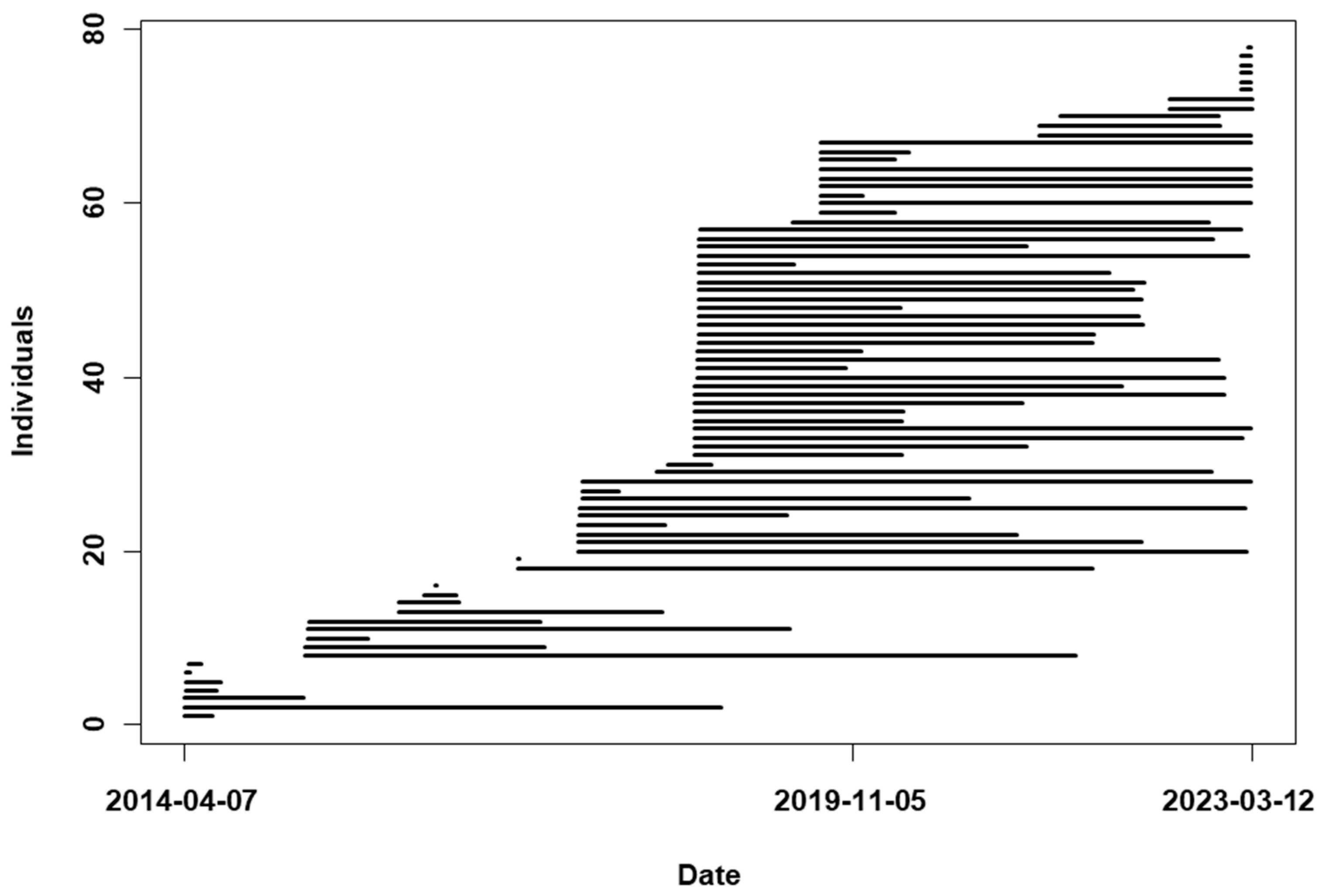
From 2014 to 2022, we tracked 78 White-naped Cranes and obtained 1,036,789 valid occurrences, with 56 individuals and 268,244 occurrences at Poyang Lake within the latitude and longitude range of 28–30° and 115–117°. The distribution of accuracy levels is as follows: Level A comprises 208,042 cases (77.6%), Level B includes 49,956 cases (18.6%), Level C consists of 7840 instances (2.9%), and Level D has 2406 occurrences (0.9%). Twenty individuals were tracked continuously for 5–7 years (Figure 3).

2.4. Hetero-Occurrence Species Distribution Models (HOSDMs)

Species Distribution Models (SDMs) are statistical tools used in ecology to predict the potential distribution of a species based on its relationship with environmental variables [30]. These models help researchers understand the factors that influence the presence or absence of a species in a given area, as well as the relative suitability of different habitats for that species [31,32]. SDMs are based on species occurrence data. However, the occurrences of one species might have different ecological meanings. For example, the forage sites and roost sites of birds might be totally different. Such difference is seldom considered in SDMs [33]. Holloway and Miller proposed the utilization of successive satellite tracking data to consider different habitat types and movement processes in SDMs; however, this suggestion has seen limited uptake by researchers [33].
We develop Hetero-occurrence Species Distribution Models (HOSDMs), which are designed to differentiate between occurrence types with the aim of enhancing model performance. To illustrate the development of a HOSDM, we utilized the winter occurrences of the White-naped Crane at Poyang Lake as an example.
The implementation of a HOSDM requires the following steps: (1) differentiate occurrences; (2) prepare environmental data; (3) build HOSDMs.

2.4.1. Differentiate Occurrences

White-naped Cranes typically forage in croplands, predominantly oilseed rape, during the day, and roost in shallow water areas at night. The cranes’ preferred shallow water areas have depths ranging from 0 to 50 cm [34]. Poyang Lake is a shallow, flat lake characterized by a main channel running through its center and extensive areas of shallow water, found both near the lake banks and in certain central regions.
In Poyang Lake area, White-naped Cranes also use wetlands. Wetlands refer to areas such as ponds, rivers, and lake shores that have freshwater grasses.
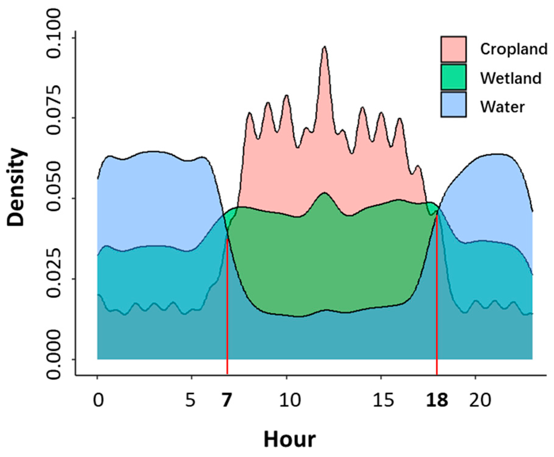
To distinguish between these two patterns (forage and rest) of habitat use, we categorized locations (water area, crop land or wetland) based on the frequency of habitat use observed on daily basis. We used density curves of activities in croplands or shallow water habitats over a 24-h period to distinguish between foraging and roosting times.

2.4.2. Prepare Environmental Data

We employed a high-resolution (30 m) land cover dataset comprising nine distinct land cover categories, i.e., cropland, forest, grassland, shrubland, wetland, water, impervious surface, bare land, and snow/ice [35]. We utilized the Terra Advanced Spaceborne Thermal Emission and Reflection Radiometer (ASTER) Global Digital Elevation Model (GDEM) Version 3 (ASTGTM) due to its matching resolution of 30 m and proven accuracy [36]. Furthermore, we incorporated four variables (Bio_1, Bio_4, Bio_12, and Bio_15) from the set of 19 climate variables, which represent mean and variance of temperature and precipitation, respectively. Additionally, we used the Human Footprint Index as an explanatory variable in our analysis, which is an integrative metric that encompasses population density, land transformation, accessibility, and electrical power infrastructure. This index quantifies human influence on a scale from 0 to 100. Moreover, we included solar radiation data for January, wind speed data for January, and water vapor pressure data for January [37]. The original resolution of these nine layers was 1 km, which we resampled to 30 m for consistency using the function projectRaster in the raster package [38]. Additionally, we added one layer for longitude and one layer for latitude with the same extent and resolution.
The twelve data layers (Table A1) were combined and stacked into a .grd file, accompanied by a corresponding .gri file, suitable for use in R. This dataset covers the geographical area within the latitude and longitude range of 28–30° and 115–117°, encompassing the entire Poyang Lake region.

2.4.3. Build HOSDMs

We employed the Random Forest algorithm [39] for species distribution modeling. The dependent variable comprised the occurrences and 900 evenly distributed pseudo-absence points represented by binary values (1/0). The independent variables consisted of twelve environmental factors (Table A1). Considering the two distinct occurrences of White-naped Cranes, we developed two separate SDMs in each year: one for foraging sites and another for roosting sites. Therefore, a HOSDM is a stage-based model that comprises these two SDMs for the White-naped Crane during foraging and roosting stages.
We utilized the cropLayer function in the R package abundanceR v 0.91 [40] to crop environmental variables to match the extent of the crane’s occurrences during the winter. The getEnvData function was used to extract the environmental variables. We developed a new R package named migrationR, which includes a custom function HOSDM. This function runs species distribution models for individuals in every year and for each occurrence type, quantifying X-Y relationship and outputting model performance indices (R2). Additionally, it predicts habitat suitability indices for foraging sites and roosting sites independently. The migrationR package is available at https://github.com/Xinhai-Li/migrationR (accessed on 14 November 2025).
The tracking data are typically recorded at a predetermined fixed interval. In the case of the transmitters used to monitor White-naped Cranes, a location signal is captured every hour. These records often exhibit spatial correlation, as birds may not move significantly within that time frame, resulting in recorded locations that are proximate to one another. Spatially explicit models can effectively account for this autocorrelation. To address spatial autocorrelation in our HOSDMs, we incorporated separate latitude and longitude layers as environmental variables to systematically quantify this inherent spatial dependence.

2.5. Comparing Daily Movement Distances

In response to the intense drought conditions, we noted that cranes traversed greater distances in search of appropriate habitats during the winter season spanning 2022–2023. To quantify these changes in migratory behavior, we employed a mixed-effects model to analyze average daily movements. Utilizing the lmer function within the lme4 package for our statistical analysis, the model was formulated as follows: Model = lmer(Distance ~ Winter * Day + Day2 + (1|ID), data = Data). Here, Distance is the mean daily distance for each crane moved across each winter season; ID is the random effect variable serving as the unique identifier for each crane; Winter is a categorical variable denoting the winter seasons from 2016 through 2023; Day functions similarly to Julian Day but starts on 15 October (coded as 1) and ends on 31 March (coded as 166); Day2 is the quadratic term of Day. It’s important to clarify that the Winter variable encapsulates entire wintering periods; for instance, ‘winter 2020’ encompasses the months of November and December in 2019, as well as January, February, and March in 2020.
We also conducted a t-test to directly compare the daily movement distances during the drought season with those in all normal seasons.
The calculated average daily movements are probably less than actual. The distance is calculated as the Euclidean distance between two consecutive hourly locations, meaning the daily movement distance is the sum of straight-line segments connecting the 24-hourly recorded points. However, cranes may follow more tortuous paths between these points. Therefore, the calculated distance represents the minimum possible movement distance.

3. Results

We demonstrate the impact of drought on White-naped Cranes through three approaches: (1) directly characterizing their movement patterns at Poyang Lake during the drought; (2) applying a Hetero-occurrence Species Distribution Model (HOSDM) to reveal distinct foraging and roosting habitats, underscoring the critical role of shallow water areas which was lost during the drought; and (3) employing a mixed-effects model to statistically compare daily movement distances between the drought year and typical years.

3.1. Daily Activities

Our tracking data revealed that White-naped Cranes predominantly forage in croplands during the day and roost in shallow water areas at night during winter (Figure 4). During 2014–2022, we recorded 118,017 occurrences in shallow water, 92,023 occurrences in croplands, 57,421 occurrences in wetlands, and only 577 occurrences in grasslands within Poyang Lake areas based on a high-resolution land cover dataset. The White-nape Crane does not inhabit forests or areas close to human residences. Analyzing land cover data, we discovered that occurrences were distributed across croplands (34.3%), water areas (43.9%), and wetlands (21.4%) respectively. White-naped Cranes exhibit a clear daily rhythm, spending the night predominantly in water areas, with 84.8% of occurrences between sunset and sunrise in these habitats (before 7 A.M. or after 6 P.M.). Conversely, during the daytime, they primarily forage in croplands, with 72.1% of cropland occurrences between 7 A.M. and 6 P.M. As shown in Figure 3, there are two distinct transition periods each day: from 7 A.M., cranes progressively allocate more time to croplands than to water areas, and from 6 P.M. onwards, the birds are increasingly likely to be found in water areas compared to croplands.
During the winter of 2022–2023, the average daily movement distance of 18 cranes that stayed in Poyang Lake was 13.3 ± 6.1 km (1107 days), significantly higher than that in previous winters (9.8 ± 4.7 km, based on 132 individuals × years in 12,560 days) (Figure A1). The difference in Box–Cox transformed daily movement distance between the winter of 2022–2023 and previous winters was significant (t test, t = 5.916, df = 612.3, p-value = 5.49 × 10⁻⁹).
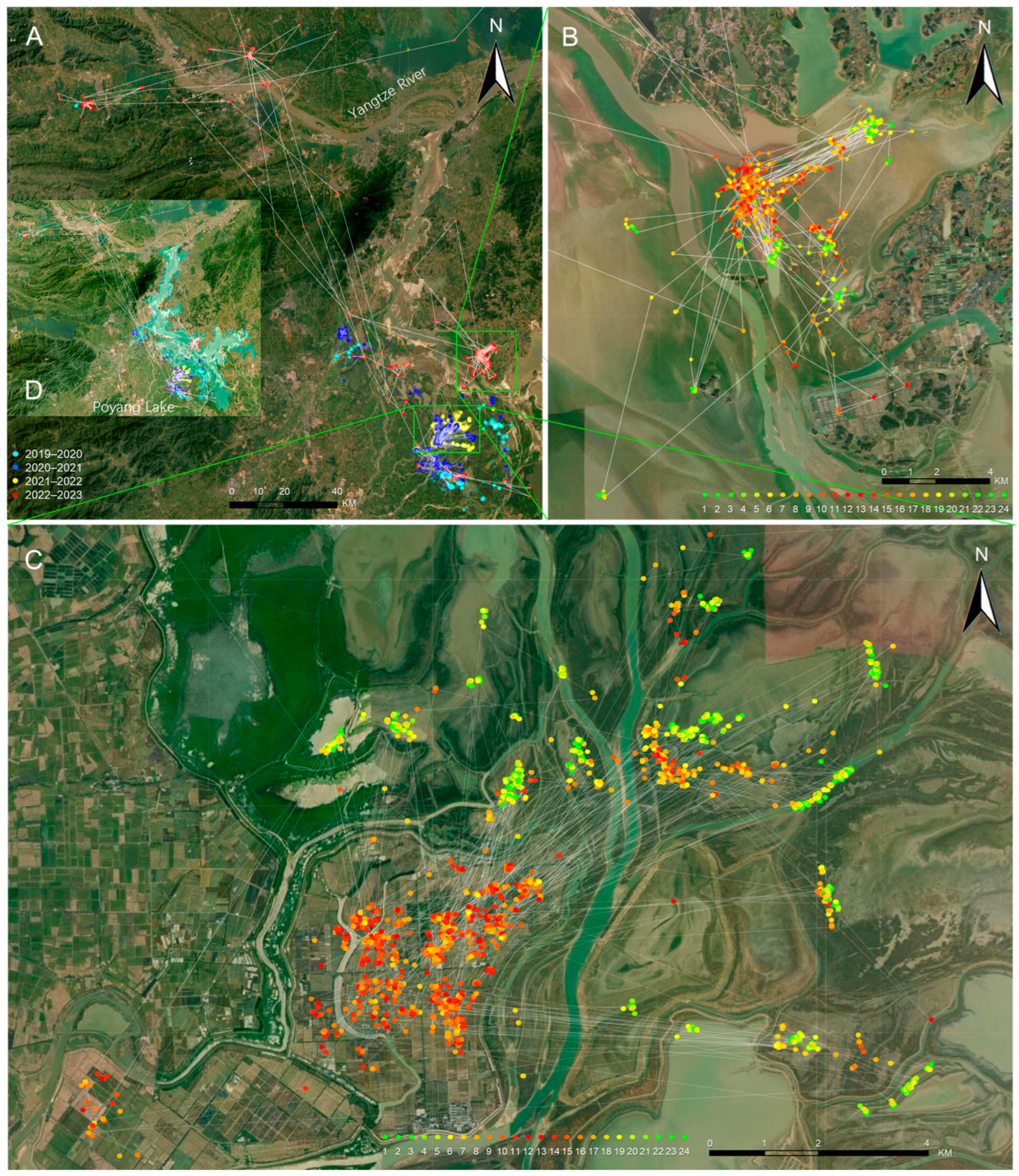
The White-naped Cranes typically utilize shallow water areas for resting and foraging [41]. However, due to the extreme drought in the winter of 2022–2023, these areas were depleted, forcing the cranes to search for other suitable habitats. We found one individual (No. 86) foraged at croplands and rested in shallow water areas in the winter of 2021–2022 (Figure 5C), but it moved more extensively (Figure 5A) and foraged in a shallow water area (Figure 5B) during the winter of 2022–2023, where there was deep water in normal years (Figure 5D). The movement of all individuals in the six winters (2018–2023) at Poyang lake is demonstrated by six GIF animation files in the Supplementary File “Animation of Crane Movements at Poyang Lake.gif”.
The wintering period in 2022–2023 was shorter than usual. The cranes typically winter at Poyang Lake for over three months. However, in the winter of 2022–2023, seven individuals stayed in Poyang Lake for less than a month. As a result, the average wintering duration in 2022–2023 (68.5 days based on 23 individuals) was much shorter than that in previous years (110.3 days based on 143 individual-years). There are no differences in arrival and leaving times for individuals wintering at Poyang Lake that stayed up to three months. We used the Julian day 288 (15 October) as the first day of the wintering period, because all individuals arrived at Poyang Lake after this date, except one individual (No. 21) staying in Poyang Lake through the summer in 2018 and 2021.

3.2. Output of Hetero-Occurrences Species Distribution Models (HOSDMs)

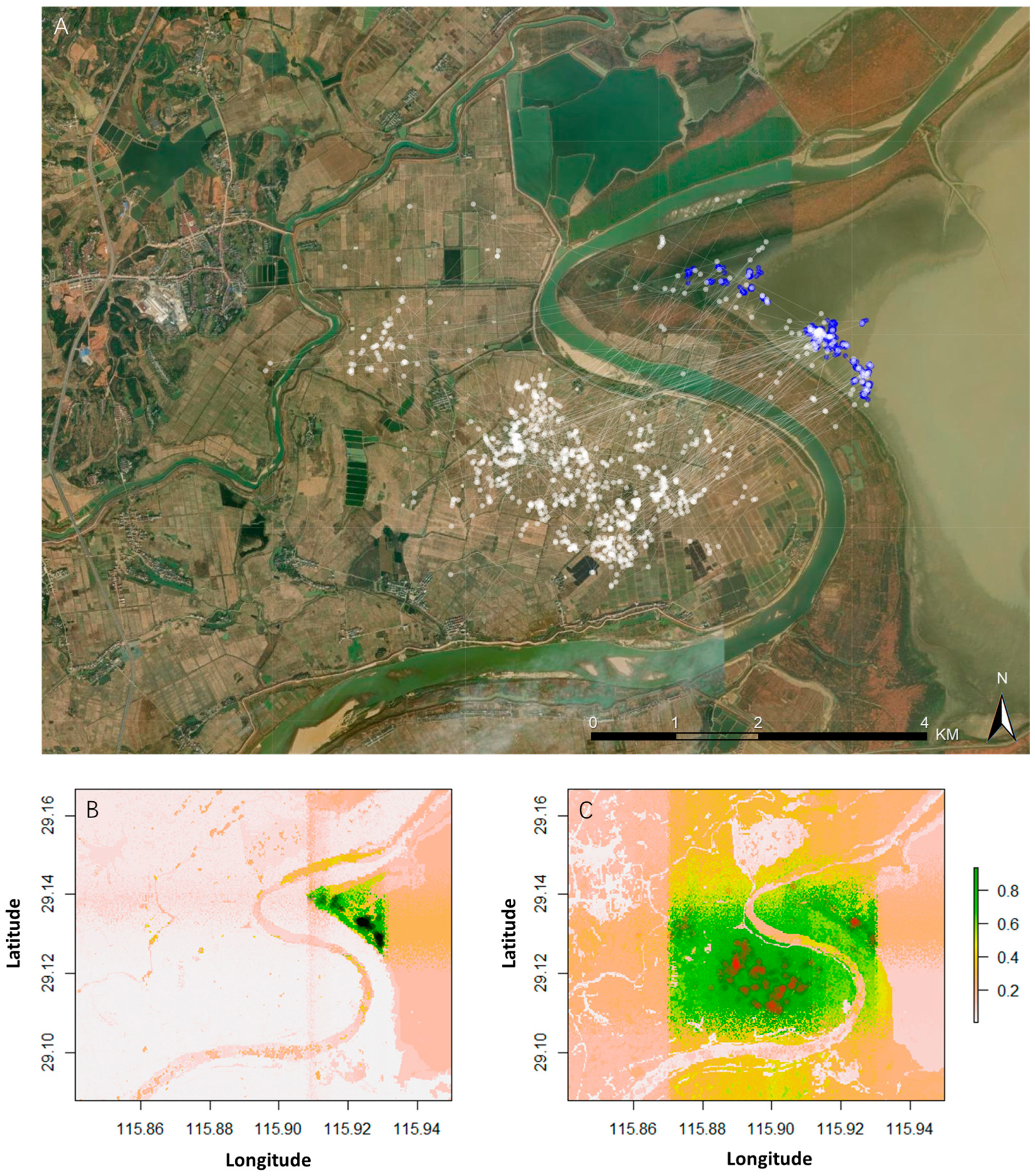
The White-naped Cranes rely on two separate habitat types, croplands and water areas, for their daily activities, so that we categorized the occurrences into two groups and executed HOSDMs accordingly. The habitat suitability predicted by HOSDMs for different occurrence types varied significantly, as the foraging areas were notably larger than resting areas (Figure 6B,C).
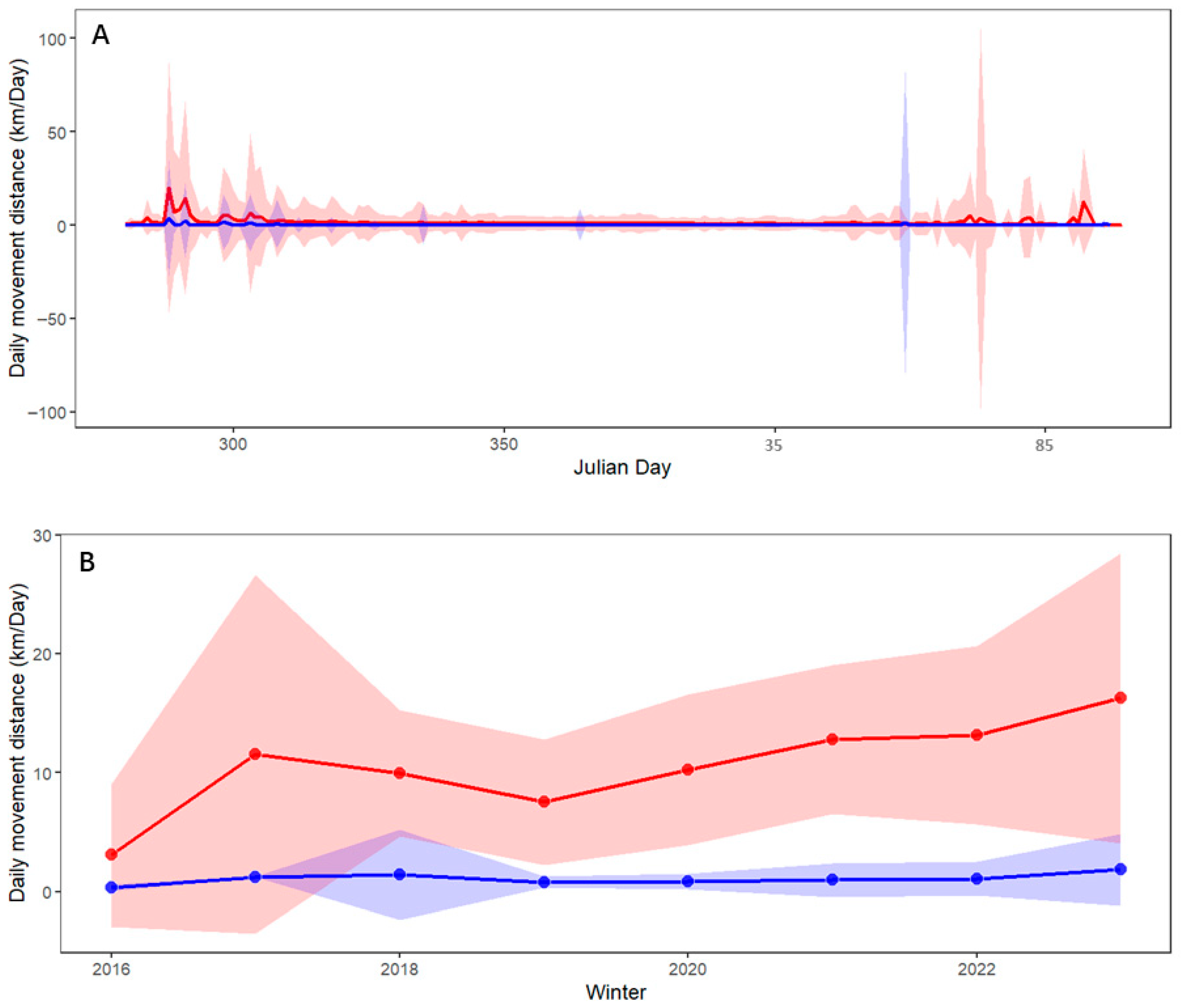
The two distinct occurrence types of the White-naped Crane correspond to different activities. The daily movement distances during foraging are significantly greater than those observed during roosting (Figure 7). These extensive daily movements were particularly prominent in the early wintering stage of October and the ending stage in March (Figure 7A). During the winter season of 2022–2023, when the lake experienced severe drought and underwent considerable shrinkage, the cranes exhibited the greatest daily movement distances during both the foraging and roosting periods (Figure 7B).
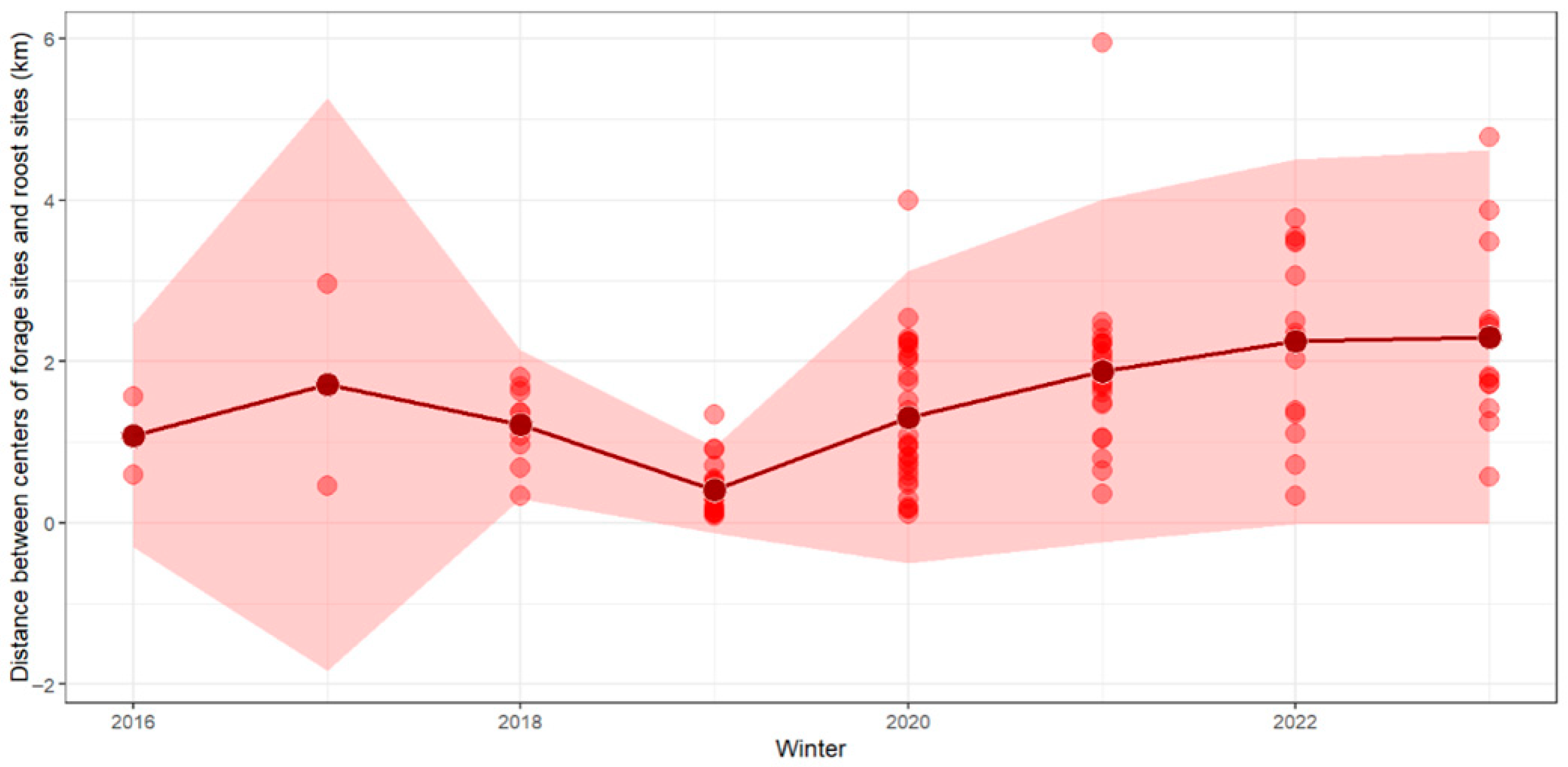
The daily distances between the centroids of foraging sites and roosting sites vary between cranes and years. Notably, the mean distance between foraging and roosting sites peaked during the dry winter of 2022–2023 (Figure A2).

3.3. Comparing Daily Movement Distance Using a Mixed Effect Model

We monitored 18 cranes throughout the winter of 2022–2023, observing that their mean daily movement distances reached the peak levels recorded since 2016 (Table 1).
In the mixed-effects model, the winter of 2022–2023 was utilized as the baseline for comparison against all preceding winters. The findings reveal the cranes moved significantly (α = 0.05) further in the winter of 2022–2023 than in four of the seven other winters we tracked cranes (Table 1). When Day was incorporated into the mixed effect model, the linear and quadratic terms of Day, as well as the interaction term are all significant (α = 0.05). Winter, which represent annual differences, still has the largest contribution to the daily movement distance (Table A2).

4. Discussion

4.1. Comparison with Other Studies

Many migratory waterbirds are experiencing severe population declines worldwide, primarily due to habitat loss [42] driven by drought [43,44]. In response to such extreme conditions, numerous bird species have been observed utilizing alternative habitats [45]. For instance, Whooping Cranes modified their habitat use and migration strategies during drought periods, increasingly relying on impounded palustrine and lacustrine systems, as well as rivers, which served as critical drought refugia [43]. Our analysis of White-naped Cranes revealed a similar pattern: during the severe drought at Poyang Lake, these birds significantly increased their use of impounded water bodies.
The record-breaking drought of 2022–2023 had profound impacts on waterbirds across the entire Yangtze River Basin. At Dongting Lake, a system comparable in size to Poyang Lake, waterbirds dispersed to surrounding wetlands following the extreme drought event [46]. Concurrently, the spatial niche of ducks underwent substantial contraction, whereas that of geese remained extensive but shifted toward lower-elevation areas [47]. At Chaohu Lake, the extreme drought dramatically reshaped the community structure of wintering waterbirds [48]. A similar community-level analysis indicated significant declines in waterbird species richness at both Dongting and Poyang Lakes [49].
At Poyang Lake specifically, satellite imagery revealed a drastic contraction in suitable habitat due to the extreme drought, resulting in substantial habitat loss for many waterbird species [50]. Shorebirds exhibited marked shifts in their distribution patterns during this period [51]. Notably, the Greater White-fronted Goose, Bean Goose, Swan Goose, and Siberian Crane expanded their home ranges during the drought and increasingly utilized artificial wetland habitats [52,53]. In this study, we demonstrated that White-naped Cranes moved significantly farther in search of suitable roosting sites during the drought season. Unlike geese, which primarily lost foraging habitat due to drought, White-naped Cranes experienced a loss of overnight resting sites.

4.2. Crane Activities During the Extreme Drought

We employed the White-naped Crane as a case study to illustrate the severe drought impacts at Poyang Lake, utilizing the daily movement distances as an indicator of habitat suitability, and larger distances in the dry season imply that the birds are expending more effort to locate appropriate habitats.
Satellite telemetry-based bird monitoring is inherently species-specific. The White-naped Crane, being an omnivore that frequently forages in croplands, provides a case study for assessing the effects of drought on croplands. During periods of drought, croplands tend to experience relatively less variation, and thus do not significantly affect the crane’s foraging habits. However, what impacts the cranes most notably is the contraction of water areas, which are crucial for their roosting activities. It is important to note that other bird species may respond differently to drought conditions. For instance, carnivorous waterbirds could suffer more severely from drought as reported by Jitariu et al. [12].
It is important to note that we currently lack evidence of lower survival rates, poorer body condition, or reduced reproduction in White-naped Cranes during the upcoming breeding season as a result of the extreme drought at Poyang Lake.

4.3. Application of HOSDMs

Species distribution models, as powerful tools for quantifying species–environment relationships, are increasingly incorporating more nuanced and detailed features. For instance, occupancy models use repeated surveys to explicitly account for detection probability, thereby providing a more accurate estimation of species distributions [54]. Multi-species distribution models enhance model fit by leveraging shared ecological preferences or functional traits across species [55]. Meanwhile, multi-level species distribution models integrate species occurrence data with both coarse-scale climate variables and fine-scale physiographic characteristics, such as terrain, soil, and vegetation, to infer fine-scale bioclimatic patterns [56]. While most SDMs treat all occurrences of a species uniformly, HOSDMs stand out as the only approach that distinguishes among different types of occurrences for a single species. We believe HOSDMs are applicable for many species, which may exhibit a diverse array of occurrence types. The fundamental strength of utilizing HOSDMs lies in their ability to precisely discern these different habitat usage patterns. The function plot_traj_segments within the migrationR package is instrumental in this regard, as it enables researchers to visualize bird movement trajectories at multiple temporal resolutions (e.g., one day, one week, or 50 days). This feature greatly supports users in interpreting migratory and resident behavior, thereby facilitating the clear differentiation between various forms of occurrences that a species may encounter during its life cycle.
Many waterbirds move between discrete habitat patches, and their movement behaviors are associated with landscape features [57]. HOSDMs can also help researchers to distinguish different habitat types or composed landscape features and enable users to better understand species–environment relationship.

4.4. Debate About Dam Construction at Poyang Lake

The recent severe drought that occurred in the Poyang Lake region has underscored the vulnerability of White-naped Cranes’ crucial roosting habitats, primarily shallow water zones. This highlights the urgent need for measures to preserve suitable water levels for these avian species. One potential solution is the strategic construction of a dam that could significantly alleviate the adverse impacts of drought on habitat availability.
Previously, the local government’s proposal to construct a dam was rejected due to concerns about its severe impact on biodiversity [58]. However, the recurrence of an extreme drought during the winter has revived the proposal for reconsideration.
The newly proposed dam at Poyang Lake is a sophisticated hydraulic infrastructure designed to facilitate seamless two-way water transfer between the lake and the Yangtze River [59]. It aims to regulate lake levels, artificially controlling the lake inundation area during the recession season (September–October) and the dry season (November–December) [60]. During periods of extreme drought, dam operations can help maintain water levels to support wintering waterbirds. However, dam construction is now subject to stricter environmental regulations, and the project faces additional scrutiny due to the negative impacts observed from the Three Gorges Dam, such as reduced water supplies in downstream areas [61]. These factors make obtaining approval for the Poyang Lake dam more challenging.
Climate change gradually affects biodiversity on the planet, while stochastic extreme events might have more profound impacts [62]. The threat of drought to waterbirds is real and has caused severe consequences (e.g., [10,12]). If a dam is built, we strongly recommend regulating the water level to support biodiversity rather than prioritizing economic benefits.

5. Conclusions

The increasing frequency and intensity of extreme climatic events, such as droughts, pose significant threats to waterbird populations worldwide. The unprecedented drought at Poyang Lake during the winter of 2022–2023 provided a critical opportunity to examine the ecological impacts of such events on the White-naped Crane, a species of conservation concern. By analyzing over 268,615 GPS tracking records from 56 individuals collected between 2014 and 2023 at Poyang Lake, we found that habitat suitability for White-naped Cranes reached its lowest level during this extreme drought period. The reduction in available shallow water areas, vital for nocturnal roosting, forced cranes to travel greater distances in search of suitable habitats, likely increasing energetic costs and exposure to potential threats. These findings emphasize the urgent need to protect and manage both foraging and roosting habitats at Poyang Lake, particularly under the growing pressures of climate change. We developed HOSDMs to separately predict suitable foraging and roosting sites, and found that the mean distance between these foraging and roosting locations peaked during the drought season. To facilitate the application of HOSDMs, which uniquely allow different types of occurrences to be treated distinctly, we provide an R package, migrationR. This capability represents a major contribution of our study toward advancing species distribution modeling.

Supplementary Materials

The following supporting information can be downloaded at: https://www.mdpi.com/article/10.3390/su172310429/s1, Animation of Crane Movements at Poyang Lake.gif.

Author Contributions

Conceptualization, Y.G., L.W. and X.L.; methodology, X.L.; software, X.L.; validation, Y.G., L.W. and L.N.; formal analysis, Y.G., L.W. and X.L.; investigation, Y.G. and L.W.; resources, L.N.; data curation, Y.G. and L.W.; writing—original draft preparation, Y.G., L.W. and X.L.; writing—review and editing, Y.G., L.W., L.N. and X.L.; visualization, Y.G. and L.W.; supervision, Y.G.; project administration, Y.G.; funding acquisition, Y.G. and X.L. All authors have read and agreed to the published version of the manuscript.

Funding

This work was supported by Intergovernmental International Science and Technology Innovation Cooperation Program under National Key Research and Development Plan (2024YFE0198600), the National Natural Science Foundation of China (No. 31770573, 31970432), and the Third Xinjiang Scientific Expedition Project (Grant No. 2021XJKK1302).

Institutional Review Board Statement

Not applicable.

Informed Consent Statement

Not applicable.

Data Availability Statement

The original data presented in the study are openly available in Dryad repository at http://datadryad.org/share/9WRCf6WlmKwjRteE8KExmJwD0fV_ul3nxQfHKH8a57M (accessed on 15 May 2024). The dataset includes Excel spreadsheets for daily flying distances of all individuals wintering at Poyang Lake, and hourly habitat use records, and migration timing data, and a compressed installation package for the migrationR R package. Official permissions for handling cranes were also included.

Acknowledgments

We thank the China National Forestry and Grass Administration, Forestry and Grassland Bureau of the Inner Mongolia Autonomous Region, Beijing Wildlife Rescue and Rehabilitation Center. We are also grateful to Gankhuyag, Baasansuren, Amarkhuu and Bundaa in Mongolian Bird Conservation Center, Dashdorj and Oyunchimeg in Eastern Mongolian Protected Areas Administration, and Oleg in Daursky Nature Reserve of Russia. We declare that the handling of cranes and all other experiments were conducted in compliance with the current laws of China, Russia, and Mongolia.

Conflicts of Interest

The authors declare no conflicts of interest.

Appendix A

Table A1. Variable parameters and data sources used in the Hetero-occurrence Species Distribution Models for the Poyang Lake region.
VariablesParametersUnitCitation
MeanMinimumMaximumSD
Bio_1 (Annual Mean Temperature)17.411.418.80.8°C
Bio_4 (Temperature Seasonality (standard deviation × 100))870.5804.3918.119.7°C
Bio_12 (Annual Precipitation)1556.91371191290.1mm
Bio_15 (Precipitation Seasonality (Coefficient of Variation))57.648.563.43.1/
Elevation85.101530145.6m
Human footprint index 15.10.0348.235.97/
Solar radiation in January9324.283049843277.5kJ m−2
day−1
Wind speed in January 2.01.73.00.14m s−1
Water vapor pressure in January0.640.440.740.055kPa
Land cover/////[35]
Longitude116115117 1 / 3 degree
Latitude292830 1 / 3 degree
Table A2. The results of the mixed effect model showing the contribution, sum of square of the daily movement distance that were explained by the fixed variables.
nparSum SqMean SqF Value
Day1357.59357.59658.54
Winter7504.9472.13132.84
I (Day2)1135.95135.95250.36
Day:Winter770.1710.0218.46
Table A3. The departure dates of the White-naped cranes from Poyang Lake from 2014 to 2023.
YearDeparture Dates (Mean Values of Julian Day)Standard Deviation of Departure DatesNumber of Individuals
2014129.02.82
2015131.832.74
201691.244.46
201763.514.06
201877.517.013
201973.511.933
202072.713.532
202166.817.625
202266.79.813
202351.215.411
Figure A1. The daily movement distance of the White-naped Cranes at Poyang Lake during the wintering period. The first day is the Julian day 288 (15 October, when cranes start to arrive at Poyang lake), and days in next year were added by 365. The color sequence from red to green represents individuals wintering from 2016 to 2022. The back dots and lines represent the daily movement distance of individuals wintering in 2022–2023.
Sustainability 17 10429 g0a1
Figure A2. Daily distances between the centroids of foraging sites and roosting sites for White-naped Cranes at Poyang Lake during winter. Each red point represents the mean distance of an individual in a year. The dark red points represent the mean values. The shaded region shows the 95% confidence intervals.
Sustainability 17 10429 g0a2

References

  1. Touma, D.; Ashfaq, M.; Nayak, M.A.; Kao, S.-C.; Diffenbaugh, N.S. A multi-model and multi-index evaluation of drought characteristics in the 21st century. J. Hydrol. 2015, 526, 196–207. [Google Scholar] [CrossRef]
  2. Mukherjee, S.; Mishra, A.; Trenberth, K.E. Climate change and drought: A perspective on drought indices. Curr. Clim. Change Rep. 2018, 4, 145–163. [Google Scholar] [CrossRef]
  3. Alexander, L.V.; Tapper, N.; Zhang, X.; Fowler, H.J.; Tebaldi, C.; Lynch, A. Climate extremes: Progress and future directions. Int. J. Climatol. 2009, 29, 317–319. [Google Scholar] [CrossRef]
  4. Cook, B.I.; Ault, T.R.; Smerdon, J.E. Unprecedented 21st century drought risk in the American Southwest and Central Plains. Sci. Adv. 2015, 1, e1400082. [Google Scholar] [CrossRef] [PubMed]
  5. Trenberth, K.E.; Dai, A.; Van Der Schrier, G.; Jones, P.D.; Barichivich, J.; Briffa, K.R.; Sheffield, J. Global warming and changes in drought. Nat. Clim. Change 2014, 4, 17–22. [Google Scholar] [CrossRef]
  6. Sheffield, J.; Wood, E.F.; Roderick, M.L. Little change in global drought over the past 60 years. Nature 2012, 491, 435–438. [Google Scholar] [CrossRef] [PubMed]
  7. IPCC. Climate Change 2022: Impacts, Adaptation, and Vulnerability. Working Group II Contribution to the Sixth Assessment Report of the Intergovernmental Panel on Climate Change; IPCC: Geneva, Switzerland, 2022. [Google Scholar]
  8. Vicente-Serrano, S.M.; Peña-Angulo, D.; Beguería, S.; Domínguez-Castro, F.; Tomás-Burguera, M.; Noguera, I.; Gimeno-Sotelo, L.; El Kenawy, A. Global drought trends and future projections. Philos. Trans. R. Soc. A Math. Phys. Eng. Sci. 2022, 380, 20210285. [Google Scholar] [CrossRef] [PubMed]
  9. Gao, X.; Liang, J.; Zhu, Z.; Li, W.; Lu, L.; Li, X.; Li, S.; Tang, N.; Li, X. Drought-induced changes in hydrological and phenological interactions modulate waterbird habitats dynamics. J. Hydrol. 2023, 626, 130228. [Google Scholar] [CrossRef]
  10. Barbaree, B.A.; Reiter, M.E.; Hickey, C.M.; Strum, K.M.; Isola, J.E.; Jennings, S.; Tarjan, L.M.; Strong, C.M.; Stenzel, L.E.; Shuford, W.D. Effects of drought on the abundance and distribution of non-breeding shorebirds in central California, USA. PLoS ONE 2020, 15, e0240931. [Google Scholar] [CrossRef]
  11. Herremans, M. Effects of drought on birds in the Kalahari, Botswana. Ostrich-J. Afr. Ornithol. 2004, 75, 217–227. [Google Scholar] [CrossRef]
  12. Jitariu, V.; Dorosencu, A.; Ichim, P.; Ion, C. Severe drought monitoring by remote sensing methods and its impact on wetlands birds assemblages in Nuntași and Tuzla Lakes (Danube Delta Biosphere Reserve). Land 2022, 11, 672. [Google Scholar] [CrossRef]
  13. Butler, M.J.; Metzger, K.L.; Harris, G. Whooping crane demographic responses to winter drought focus conservation strategies. Biol. Conserv. 2014, 179, 72–85. [Google Scholar] [CrossRef]
  14. Wang, X.; Kuang, F.; Tan, K.; Ma, Z. Population trends, threats, and conservation recommendations for waterbirds in China. Avian Res. 2018, 9, 14. [Google Scholar] [CrossRef]
  15. Yin, Z.; Zhou, B.; Duan, M.; Chen, H.; Wang, H. Climate extremes become increasingly fierce in China. Innovation 2023, 4, 100406. [Google Scholar] [CrossRef]
  16. Wang, C.; Xia, S.; Yu, X.; Wen, L. Responses to extreme drought in wintering waterbirds: A multi-species approach. Front. Zool. 2025, 22, 3. [Google Scholar] [CrossRef] [PubMed]
  17. Higuchi, H.; Pierre, J.P.; Krever, V.; Andronov, V.; Fujita, G.; Ozaki, K.; Goroshko, O.; Ueta, M.; Smirensky, S.; Mita, N. Using a remote technology in conservation: Satellite tracking White-naped cranes in Russia and Asia. Conserv. Biol. 2004, 18, 136–147. [Google Scholar] [CrossRef]
  18. Si, Y.; Xu, Y.; Xu, F.; Li, X.; Zhang, W.; Wielstra, B.; Wei, J.; Liu, G.; Luo, H.; Takekawa, J.; et al. Spring migration patterns, habitat use, and stopover site protection status for two declining waterfowl species wintering in China as revealed by satellite tracking. Ecol. Evol. 2018, 8, 6280–6289. [Google Scholar] [CrossRef]
  19. Zhu, Q.; Hobson, K.A.; Zhao, Q.; Zhou, Y.; Damba, I.; Batbayar, N.; Natsagdorj, T.; Davaasuren, B.; Antonov, A.; Guan, J.; et al. Migratory connectivity of Swan Geese based on species’ distribution models, feather stable isotope assignment and satellite tracking. Divers. Distrib. 2020, 26, 944–957. [Google Scholar] [CrossRef]
  20. Li, J.; Qian, F.; Zhang, Y.; Zhao, L.; Deng, W.; Ma, K. Identifying seasonal differences in migration characteristics of Oriental white stork (Ciconia boyciana) through satellite tracking and remote sensing. Ecol. Indic. 2023, 146, 109760. [Google Scholar] [CrossRef]
  21. Finlayson, M.; Harris, J.; McCartney, M.; Lew, Y.; Zhang, C. Report on Ramsar visit to Poyang Lake Ramsar site, PR China. In Proceedings of Secretariat of the Ramsar Convention; International Union for the Conservation of Nature: Gland, Switzerland, 2010. [Google Scholar]
  22. Wang, Y.; Molinos, J.G.; Shi, L.; Zhang, M.; Wu, Z.; Zhang, H.; Xu, J. Drivers and changes of the Poyang Lake wetland ecosystem. Wetlands 2019, 39, 35–44. [Google Scholar] [CrossRef]
  23. Suliman, M.; Deng, W.; Wu, Q.; Ahmad, T.; Sun, X.; Tsegaye, D.M.; Khan, M.S.; Trang, N.T.K.; Zou, H. Evaluation of lake fragmentation and its effect on wintering waterbirds in Poyang lake, china. Diversity 2024, 16, 154. [Google Scholar] [CrossRef]
  24. Shao, M.; Wang, J.; Ding, H.; Yang, F. Response of Siberian cranes (Grus leucogeranus) to hydrological changes and the availability of foraging habitat at various water levels in Poyang lake. Animals 2024, 14, 234. [Google Scholar] [CrossRef]
  25. Li, X.; Hu, B.; Qi, S.; Luo, J. The influence of short-term water level fluctuations on the habitat response and ecological fragility of Siberian cranes in Poyang lake, China. Remote Sens. 2024, 16, 4431. [Google Scholar] [CrossRef]
  26. Li, Y.; Dong, X.; Hu, C. The impact of ecological water level on wintering migratory birds in Poyang Lake—Focusing on phytophagous geese. Ecol. Indic. 2024, 169, 112946. [Google Scholar] [CrossRef]
  27. Shao, M.; Jiang, J.; Liao, Z. Population sizes and flocking features of wintering common cranes and white-naped cranes in Poyang Lake. J. Ecol. Rural. Environ. 2014, 30, 464–469. [Google Scholar]
  28. Fujita, G.; Guan, H.L.; Ueta, M.; Goroshko, O.; Krever, V.; Ozaki, K.; Mita, N.; Higuchi, H. Comparing areas of suitable habitats along travelled and possible shortest routes in migration of White-naped Cranes Grus vipio in East Asia. Ibis 2004, 146, 461–474. [Google Scholar] [CrossRef]
  29. Lang, X.; Purev-Ochir, G.; Terbish, O.; Khurelbaatar, D.; Erdenechimeg, B.; Gungaa, A.; Mi, C.; Guo, Y. Luan River upper reaches: The important stopover site of the white-naped crane (Grus vipio) western population. Biodivers. Sci. 2020, 28, 1213–1221, 0300–0307. [Google Scholar] [CrossRef]
  30. Guisan, A.; Thuiller, W. Predicting species distribution: Offering more than simple habitat models. Ecol. Lett. 2005, 8, 993–1009. [Google Scholar] [CrossRef] [PubMed]
  31. McShea, W.J. What are the roles of species distribution models in conservation planning? Environ. Conserv. 2014, 41, 93–96. [Google Scholar] [CrossRef]
  32. Li, X.H.; Wang, Y. Applying various algorithms for species distribution modeling. Integr. Zool. 2013, 8, 124–135. [Google Scholar] [CrossRef]
  33. Holloway, P.; Miller, J.A. A quantitative synthesis of the movement concepts used within species distribution modelling. Ecol. Model. 2017, 356, 91–103. [Google Scholar] [CrossRef]
  34. Wang, R.-N.; Liu, X.-B.; Chen, X.-K.; Han, Z.; Peng, W.-Q. Studies on the suitable ecological water level of Poyang Lake national nature reserve based on the habitat needs of white cranes. In Advances in Civil Engineering and Environmental Engineering; CRC Press: Boca Raton, FL, USA, 2023; Volume 2, pp. 421–428. [Google Scholar]
  35. Gong, P.; Wang, J.; Yu, L.; Zhao, Y.; Zhao, Y.; Liang, L.; Niu, Z.; Huang, X.; Fu, H.; Liu, S.; et al. Finer resolution observation and monitoring of global land cover: First mapping results with Landsat TM and ETM+ data. Int. J. Remote Sens. 2013, 34, 2607–2654. [Google Scholar] [CrossRef]
  36. Polidori, L.; El Hage, M. Digital elevation model quality assessment methods: A critical review. Remote Sens. 2020, 12, 3522. [Google Scholar] [CrossRef]
  37. Hijmans, R.J.; Cameron, S.E.; Parra, J.L.; Jones, P.G.; Jarvis, A. Very high resolution interpolated climate surfaces for global land areas. Int. J. Climatol. 2005, 25, 1965–1978. [Google Scholar] [CrossRef]
  38. Hijmans, R.J.; Van Etten, J.; Cheng, J.; Mattiuzzi, M.; Sumner, M.; Greenberg, J.A.; Lamigueiro, O.P.; Bevan, A.; Racine, E.B.; Shortridge, A. Package ‘raster’. R Package 2015, 734, 473. [Google Scholar]
  39. Breiman, L. Random forests. Mach. Learn. 2001, 45, 5–32. [Google Scholar] [CrossRef]
  40. Li, X.; Li, N.; Li, B.; Sun, Y.; Gao, E. abundanceR: A novel method for estimating wildlife abundance based on distance sampling and species distribution models. Land 2022, 11, 660. [Google Scholar] [CrossRef]
  41. Harris, J.; Liying, S.; Higuchi, H.; Ueta, M.; Zhengwang, Z.; Yanyun, Z.; Xijun, N. Migratory stopover and wintering locations in eastern China used by White-naped Cranes Grus vipio and Hooded Cranes G. monacha, as determined by satellite tracking. Forktail 2000, 16, 93–99. [Google Scholar]
  42. de Felipe, M.; Amat, J.A.; Arroyo, J.L.; Rodríguez, R.; Díaz-Paniagua, C. Habitat Changes at the Local Scale Have Major Impacts on Waterfowl Populations Across a Migratory Flyway. Glob. Change Biol. 2024, 30, e17600. [Google Scholar] [CrossRef]
  43. Pearse, A.T.; Caven, A.J.; Baasch, D.M.; Bidwell, M.T.; Conkin, J.A.; Brandt, D.A. Flexible migration and habitat use strategies of an endangered waterbird during hydrological drought. Conserv. Sci. Pract. 2024, 6, e13120. [Google Scholar] [CrossRef]
  44. Feng, X.; Merow, C.; Liu, Z.; Park, D.S.; Roehrdanz, P.R.; Maitner, B.; Newman, E.A.; Boyle, B.L.; Lien, A.; Burger, J.R. How deregulation, drought and increasing fire impact Amazonian biodiversity. Nature 2021, 597, 516–521. [Google Scholar] [CrossRef]
  45. Moore, H.A.; Cresswell, A.K. Drought in south-west Australia links to urban immigration across multiple avian taxa. Pac. Conserv. Biol. 2024, 30, PC24058. [Google Scholar] [CrossRef]
  46. Feng, L.; Shi, J.; Xiao, Y.; Liao, L.; Zhou, Z.; Xu, J.; Li, Y.; Tian, Y.; Niu, Y. Impact of Extreme Drought on Waterbird Abundance: A Case Study Based on the Core Nature Reserve and Surrounding Wetlands. Ecol. Evol. 2025, 15, e71258. [Google Scholar] [CrossRef]
  47. Zhang, P.; Zou, Y.; Tao, K.; Zhang, S.; Li, F.; Deng, Z.; Zeng, J.; Xie, Y.; Liu, X.; Li, F. Extreme drought alters waterfowl distribution patterns and spatial niches in floodplain wetlands. Glob. Ecol. Conserv. 2024, 51, e02901. [Google Scholar] [CrossRef]
  48. Xia, S.; Han, J.; Ji, X.; Zhou, L. Influence of extreme drought events on wintering waterbird metacommunities in high-water-level gate-controlled lake basin: A functional group perspective. Glob. Ecol. Conserv. 2025, 62, e03818. [Google Scholar] [CrossRef]
  49. Gao, X.; Liang, J.; Zhu, Z.; Li, W.; Lu, L.; Qiu, X.; Li, S.; Tang, N.; Li, X. Unraveling the impact of drought on waterbird community assembly and conservation strategies. J. Environ. Manag. 2025, 373, 123685. [Google Scholar] [CrossRef]
  50. Liu, X.; Yuan, L.; Li, Z.; Huang, Y.; Li, Y. Mapping Habitat Suitability of Migratory Birds During Extreme Drought of Large Lake Wetlands: Insights from Crowdsourced Geographic Data. Land 2025, 14, 1236. [Google Scholar] [CrossRef]
  51. Yan, Z.; Shao, M. Response of Landscape Types and Shorebird Diversity to Extreme Drought Climate in Poyang Lake, China During the Non-Breeding Period. Animals 2025, 15, 1399. [Google Scholar] [CrossRef]
  52. Wang, C.; Xia, S.; Yu, X.; Wen, L.; Choi, C.-Y. Artificial wetlands as drought refugia for wintering geese: Adaptive use or ecological mismatch? Biol. Conserv. 2026, 313, 111545. [Google Scholar] [CrossRef]
  53. Wang, Z.; Zhou, J.; He, Y.; Zhang, Y.; Liu, P.; Jia, Y.; Lu, C.; Lei, G. Spatially Diverse Water Levels Enhance Habitat Heterogeneity for Wintering Waterbirds. Freshwat. Biol. 2025, 70, e70016. [Google Scholar] [CrossRef]
  54. MacKenzie, D.I.; Nichols, J.D.; Lachman, G.B.; Droege, S.; Royle, J.A.; Langtimm, C.A. Estimating site occupancy rates when detection probabilities are less than one. Ecology 2002, 83, 2248–2255. [Google Scholar] [CrossRef]
  55. Vermeiren, P.; Reichert, P.; Schuwirth, N. Integrating uncertain prior knowledge regarding ecological preferences into multi-species distribution models: Effects of model complexity on predictive performance. Ecol. Model. 2020, 420, 108956. [Google Scholar] [CrossRef]
  56. Kling, M.M.; Baer, K.C.; Ackerly, D.D. A tree’s view of the terrain: Downscaling bioclimate variables to high resolution using a novel multi-level species distribution model. Ecography 2024, 2024, e07131. [Google Scholar] [CrossRef]
  57. Kleyheeg, E.; van Dijk, J.G.B.; Tsopoglou-Gkina, D.; Woud, T.Y.; Boonstra, D.K.; Nolet, B.A.; Soons, M.B. Movement patterns of a keystone waterbird species are highly predictable from landscape configuration. Mov. Ecol. 2017, 5, 2. [Google Scholar] [CrossRef] [PubMed]
  58. Wu, H.; Chen, J.; Xu, J.; Zeng, G.; Sang, L.; Liu, Q.; Yin, Z.; Dai, J.; Yin, D.; Liang, J. Effects of dam construction on biodiversity: A review. J. Clean. Prod. 2019, 221, 480–489. [Google Scholar] [CrossRef]
  59. Zhang, Q.; Xue, C.; Xia, J. Impacts, contributing factors and countermeasures of extreme droughts in Poyang Lake. Bull. Chin. Acad. Sci. 2023, 38, 1894–1902. (In Chinese) [Google Scholar] [CrossRef]
  60. Jiang, W.; Liu, B.; Li, Y.; Lu, C.; Shu, L. The effects of damming and dam regulation on a river–lake-aquifer system: 3D groundwater flow modeling of Poyang Lake (China). J. Hydrol. 2024, 636, 131311. [Google Scholar] [CrossRef]
  61. Li, K.; Zhu, C.; Wu, L.; Huang, L. Problems caused by the Three Gorges Dam construction in the Yangtze River basin: A review. Environ. Rev. 2013, 21, 127–135. [Google Scholar] [CrossRef]
  62. Clark, J.S.; Iverson, L.; Woodall, C.W.; Allen, C.D.; Bell, D.M.; Bragg, D.C.; D’Amato, A.W.; Davis, F.W.; Hersh, M.H.; Ibanez, I.; et al. The impacts of increasing drought on forest dynamics, structure, and biodiversity in the United States. Glob. Change Biol. 2016, 22, 2329–2352. [Google Scholar] [CrossRef]
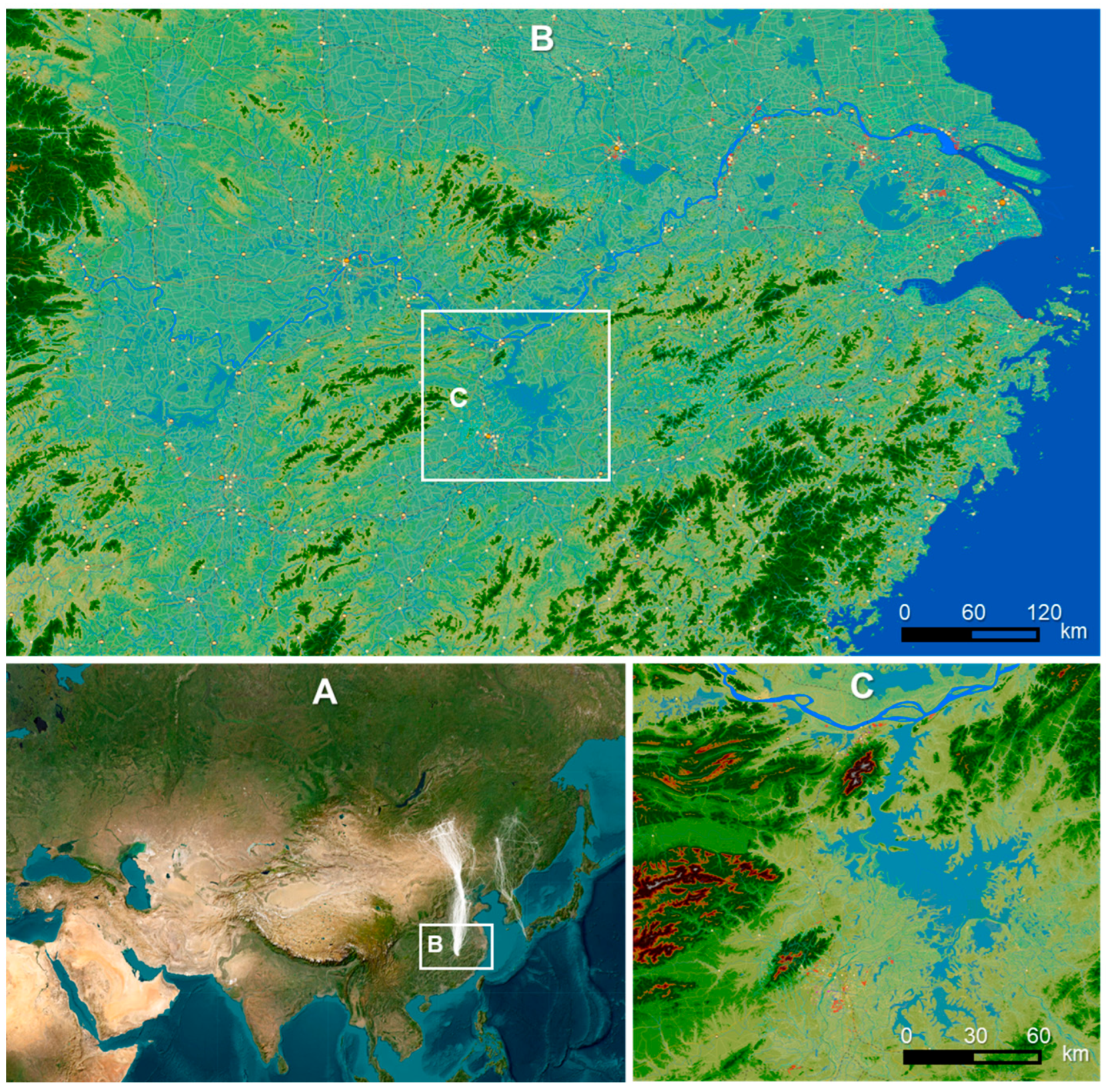
Figure 1. The location of Poyang Lake. (A) The East Asia area with migration trajectories (white lines) of 78 tracked White-naped Cranes. (B) The Lower Yangtze River Basin. (C) The Poyang Lake. Poyang Lake is situated on the southern side of the Yangtze River (dark blue). The background of panel (A) is a satellite image, and the background color of panels (B,C) indicates elevation.
Sustainability 17 10429 g001
Figure 2. The monthly and annual water levels at Xingzi Station in Poyang lake. (A). The monthly mean water levels (the lines from red to green represent years from 1990 to 2022). The blue points show the monthly maximum water levels, and the brown points show the monthly minimum water levels. The points were jittered in order to avoid overlap. Different lines represent different years: red indicates older years, green represents more recent years, and yellow denotes intermediate years. (B). The annual minimum water levels (always in winter time) from 1990 to 2022, while the mean value across these years is 8.0 m. The vertical line at year 2006 indicates the year when the Three Gorge Dam was built. Blue indicates wet years, and brown indicates dry years.
Sustainability 17 10429 g002
Figure 3. Track duration for each individual White-naped Crane. The dates on the x-axis are the first day, median day (the date of the median record for the species), and the last day of tracking. This figure was plotted using function plot_track_duration in package migrationR.
Sustainability 17 10429 g003
Figure 4. The distribution of occurrence frequencies for all White-naped Cranes at Poyang Lake across croplands, wetlands, and water areas within a 24-h period. The red lines indicate the transition points between the nocturnal and daytime stages.
Sustainability 17 10429 g004
Figure 5. The movement trajectories of a White-naped Crane (No. 86) in Poyang Lake. (A) The movement trajectories of the crane in four winter seasons from 2019–2020 to 2022–2023. (B) Foraging and resting area in the winter of 2022–2023. (C) Foraging and resting area in the winter of 2021–2022. (D) The wintering area of the Crane and the average size of Poyang Lake in summer time. In (B,C), red points indicate noon time, yellow points refer dusk and dawn, and green points mean night time. In normal years, this individual foraged at croplands and rested in shallow water areas (C). During the drought winter of 2022–2023, this individual moved more extensively (A) and foraged in a shallow water area (B), where there was deep water in normal years (D).
Sustainability 17 10429 g005
Figure 6. Occurrences and predicted habitat suitability by HOSDMs for White-naped Crane No. 84 in 2021. (A) The locations of foraging sites in croplands (white points) and roosting sites in water areas (blue points), connected by lines linking temporally successive points. (B) The predicted habitat suitability for roosting by White-naped Crane No. 84. The black points represent nocturnal occurrences. (C) The predicted habitat suitability for foraging by White-naped Crane No. 84. The red points indicate diurnal occurrences.
Sustainability 17 10429 g006
Figure 7. Daily movement distances of White-naped Cranes at Poyang Lake during winter, depicted with 95% confidence intervals shown as shaded areas. (A) The average daily movement distances for all individuals from October to the following March. (B) The annual mean of daily movement distances for all individuals from 2016 to 2023. The red lines represent the mean values of distances during the daytime, while the blue lines indicate the mean values of distances during nighttime.
Sustainability 17 10429 g007
Table 1. The mean daily movement distance of White-naped Cranes during their wintering periods at Poyang Lake, and the differences comparing with the drought winter 2022–2023.
WintersMean Daily
Movement
Distance (km)
No. of CranesDifference Comparing with 2022–2023Std. Error of the Differencet Valuep Value
2015–20163.372−10.173.42−2.980.0015
2016–20178.563−2.832.79−1.010.1558
2017–201811.55110.421.690.250.4025
2018–20198.0533−4.481.28−3.500.0002
2019–20209.9637−2.931.24−2.370.0088
2020–202111.6427−1.451.30−1.120.1318
2021–202210.4919−2.491.39−1.790.0370
2022–202313.3418
Disclaimer/Publisher’s Note: The statements, opinions and data contained in all publications are solely those of the individual author(s) and contributor(s) and not of MDPI and/or the editor(s). MDPI and/or the editor(s) disclaim responsibility for any injury to people or property resulting from any ideas, methods, instructions or products referred to in the content.