Article

Sediment Load Decreases After the Historical 2017 Megafire in Central Chile: The Purapel in Sauzal Experimental Watershed Case Study and Its Implications for Sustainable Watershed Management

1
UNESCO Chair on Surface Hydrology, University of Talca, Lircay s/n, Talca 3465000, Chile
2
Centro Nacional de Excelencia Para la Industria de la Madera (CENAMAD)—ANID BASAL FB210015, Pontificia Universidad Católica de Chile, Santiago 7810128, Chile
3
Faculty of Forest Science and Nature Conservancy, University of Chile, Santa Rosa 10350, Santiago 8820808, Chile
4
Department of Interactive Visualization and Virtual Reality, Faculty of Engineering, Universidad de Talca, Talca 3460000, Chile
5
Faculty of Energy and Applied Sciences, Cranfield University, Cranfield MK43 0AL, UK
6
Magíster en Gestión Tecnológica, Universidad de Talca, Talca 3460000, Chile
7
Facultad de Geología, Geofísica y Minas, Universidad Nacional de San Agustín de Arequipa, Arequipa 04001, Peru
8
Department of Civil and Environmental Engineering, Colorado School of Mines, 1500 Illinois St., Golden, CO 80401, USA
9
Intergubernamental Hydrological Programme, United Nations Educational, Scientific, and Cultural Organization, Luis Piera 1992, Edificio Mercosur, 2do Piso, Montevideo 11200, Uruguay
*
Author to whom correspondence should be addressed.
Sustainability 2025, 17(22), 9930; https://doi.org/10.3390/su17229930
Submission received: 4 September 2025 / Revised: 9 October 2025 / Accepted: 30 October 2025 / Published: 7 November 2025

Abstract

Forests play a critical role in regulating hydrological processes and reducing soil erosion and sediment load. However, climate change has increased the frequency and severity of wildfires, which can significantly impact these ecosystem services. A historical megafire burned in January of 2017 in Central Chile, affecting the Purapel in Sauzal experimental watershed (an area dominated by Pinus radiata plantations), providing a unique opportunity to study post-fire sediment load dynamics. We hypothesized that sediment load would significantly increase following the wildfire, especially in areas with exotic commercial plantations. To test this, we analyzed daily sediment load and streamflow data collected the Purapel River during the 1991–2018 period, as well as other variables. Descriptive statistics and a sediment rating curve model were used to assess temporal variations in sediment load. Contrary to expectations, results showed no significant increase in sediment concentration following the devastating 2017 wildfire event. In fact, the Mann–Kendall test revealed a significant decreasing trend in winter sediment production over the study period. These findings may be explained by a reduction in precipitation during the mega-drought of the 2010s and, importantly, a rapid and dense post-fire pine seedling regeneration. This study highlights the complex interactions between climate, vegetation, and geomorphic processes, as well as the need for further research on post-fire sediment dynamics in Mediterranean plantation forests.

1. Introduction

Vegetation plays a central role on soil stabilization in upland areas, preventing erosive processes and downhill sediment transport (e.g., [1,2,3,4]). This occurs in part because vegetation incorporated into soil with organic matter in the upper horizon establishes a protective buffer against the impact of rain drops on its surface [5]. Added to this is the interception by vegetation’s above-ground components, which generally decreases the kinetic energy of raindrops falling on the ground [6,7,8]. If the vegetation cover is arboreal, water interception in the canopy is even more efficient because such interception occurs over various altitudinal strata, in addition to the trunks and roots of trees present in the area [9,10]. Assuming that the majority of rainfall (or a portion of it) reaches the soil surface during long-lasting storm events as is the case of central Chile [9,11,12], not all this water becomes immediate surface runoff; a substantial portion infiltrates into the soil [12,13], a process enhanced by organic matter and root channels that increase soil permeability [10]. Additionally, surface roughness created by vegetation debris, trunks, and stems acts as physical barriers that slow overland flow, promoting further infiltration and redirecting water into subsurface pathways and groundwater recharge [10,14,15]. Hence, the role of the soil-vegetation complex is highly relevant in regulating surface runoff, significantly reducing erosive processes and sediment emissions toward lower areas of the watershed. Moreover, this protective function of vegetation is increasingly threatened by land disturbances such as fire. Indeed, the frequency and severity of wildfires has increased globally [16,17,18,19], though this trend has manifested in complex ways in central Chile; although the number of wildfire events increased between 1984 and 2016, the total burned area remained relatively stable at approximately 58 thousand hectares (ha) annually, with an average of 4364 fire events per year [20,21]. However, this historical pattern changed dramatically with the emergence of large-scale wildfires (megafires) in this territory. Indeed, the historical 2017 wildfire season destroyed over 600,000 ha of forests (six times the previous annual maximum of 100,000 ha, though 350,000 ha were burned in 2024) [21]. These megafires particularly threaten commercial Pinus radiata plantations established decades ago for soil stabilization/restoration and land productivity purposes [22,23], forming also extensive monoculture fuel loads across the territory, making them highly vulnerable to large-scale wildfire events such as the 2017 fire season case [24,25,26]. In this context, it is necessary to understand how sediment emission rates in lower-lying areas can change by the effect of megafires, especially in areas with land use destined for commercial plantations in Mediterranean climates, as is the case of central Chile.
Wildfires are not caused by a single factor but by the intersection of thresholds related to ignitions, fuels, and droughts, which are exacerbated by extreme weather events and climate change, along with anthropogenic factors such as land use and ignition patterns [27]. Moreover, a negative (and known) effect of wildfires is the increase in sediment load within a burned watershed [28,29,30]. This increase in erosion and sediment transport is mainly due to two factors: first, the loss of vegetation cover that protects the soil [30,31,32] and second, the formation of post-fire water repellent layers on the soil surface that reduces infiltration, increases surface runoff, and makes the area more susceptible to erosion processes [33,34]. Moreover, sediment discharge curves (SDCs) have traditionally been used to quantify sediment transport as a function of flow rate [35,36,37]. These curves generally follow a potential model of the form SDC = b0Qb1, where b0 and b1 are model parameters that are fitted by linear (in its linearized form) or nonlinear regressions. Several authors have pointed out that these parameters have physical meaning: b0 is related to sediment availability and the severity of erosive processes within the basin, while b1 is the erosive potential of the channel under changes in flow rate [35,38,39,40].
In the above context, the historical 2017 megafire burned the Purapel in Sauzal experimental watershed in central Chile, providing a unique opportunity to study pre- and post-fire sediment load dynamics, as the entire burned area was colonized by a dense pine seedling cover, providing immediate protection against erosion processes. A reasonable hypothesis is that post-fire erosion processes would significantly increase sediment load, particularly given that commercial plantations in this watershed consist of exotic species in restored ecosystems. Therefore, temporal analysis of the sediment rating curve parameters (b0 and b1) will allow us to evaluate the effects of wildfires on sediment transport processes at the Purapel watershed, providing insights into the watershed’s recovery trajectory and resilience to extreme disturbances.

2. Materials and Methods

2.1. Materials

2.1.1. Data

Sediment concentration data were collected from the Purapel en Sauzal station, with information available from 1985 to 2018. These data comprise daily records of sediment concentration (mg/L), streamflow (m3/s), and precipitation (mm), providing a comprehensive 33-year dataset for analysis. However, these series contain some gaps throughout the study period (i.e., missing data) and a minimum threshold of 70% of available data, equivalent to 256 days for the annual analysis and 128 days for the dry (October–March) and wet (April–September) periods, was established. Additionally, precipitation data were obtained from the Purapel en Nirivilo station, which is located within the Purapel watershed (see Figure 1). Records for this station begin in the 1950s. All this information was collected by the General Water Directory of Chile (https://dga.mop.gob.cl, accessed on 10 October 2024).

2.1.2. Study Area

The Purapel en Sauzal experimental watershed is located in the Maule Region of Chile, between latitudes 35°24′ S and 35°48′ S. It has an area of 665 km2, with elevations ranging from 127 to 893 m.a.s.l. and a mean slope of 15.5%. This watershed originates in the coastal mountain range and is under a Mediterranean climate (Csb) characterized by winter precipitation and warm, dry summers [41], with an annual average precipitation of 721 mm.
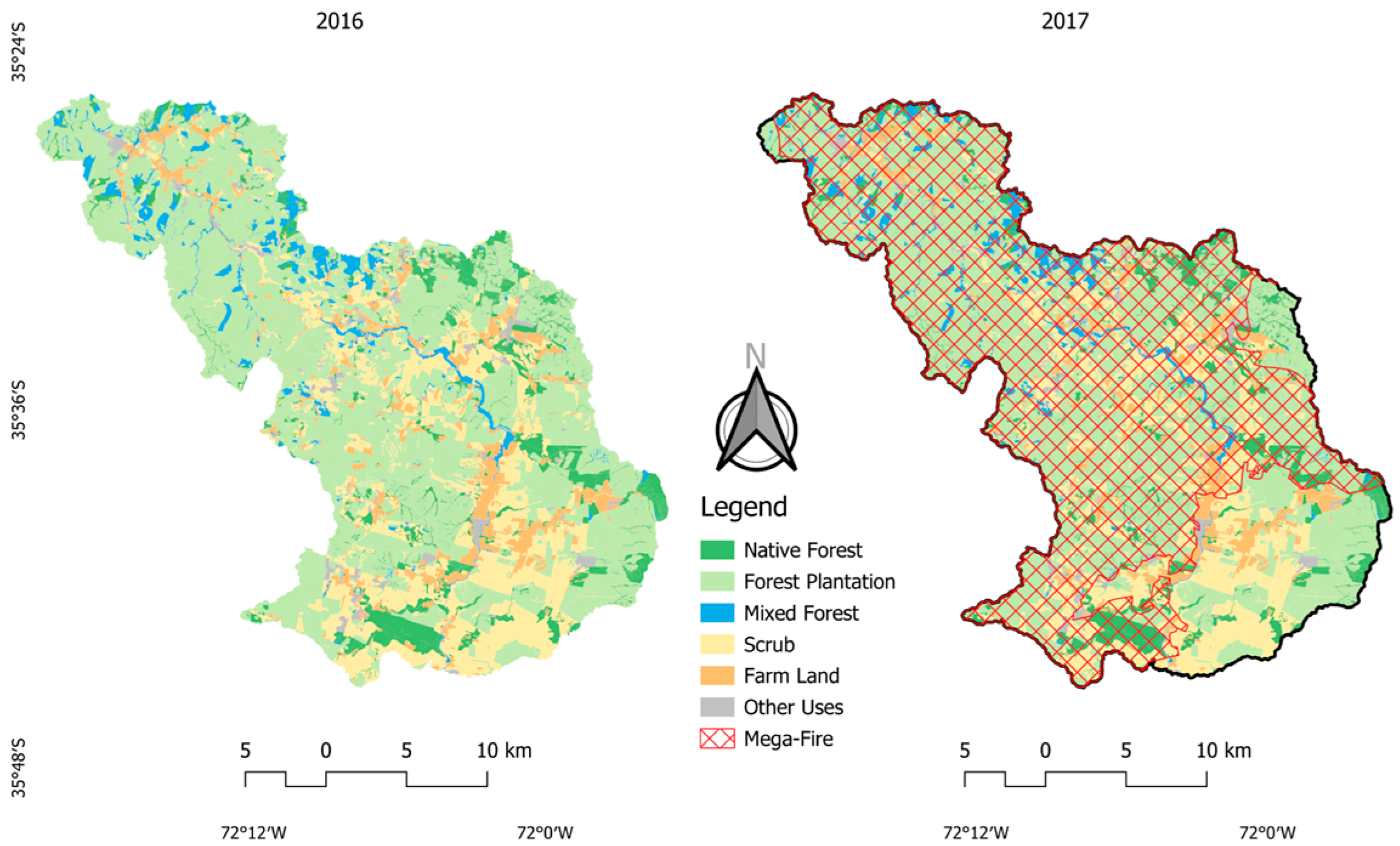
Before the 2017 megafire, the Purapel en Sauzal watershed was covered predominantly by forests, constituting almost 70% of the total watershed area. This cover was composed of three main categories (Figure 2): forest plantations (56.6%); native forest (10.3%) and mixed forest (2.7%), while the remaining 30.4% was represented by farmland and other land uses. The historical 2017 megafire consumed approximately 78% of the watershed’s surface (Figure 2).
Figure 2. Comparison between land use and burned area in the Purapel experimental watershed before (2016) and after (2017) the wildfire, obtained using remote sensing tools. Left: Land-use map for 2016, showing categories: forest plantations (56.6%), native forest (10.3%), mixed forest (2.7%), and other uses (30.4%). Right: Burned area map for 2017, indicating 78% of the affected watershed, with severity categories (based on the dNBR index, as detailed in Table 1).
Sustainability 17 09930 g002
Table 1. Area of dNBR analysis assigned to each category (ha).
Label20172018
Unburned23,55747,521
Enhanced Regrowth, Low8533150
Enhanced Regrowth, High8351
Low Severity13,38614,921
Moderate-low Severity11,041454
Moderate-high Severity954716
High Severity80211
A descriptive analysis of soil in the watershed was already performed by Galleguillos et al. [42] using the CLSoilMaps layer. Analysis of the 0–5 cm horizon revealed that the dominant texture classes are Sandy Clay Loam (43%) and Loam (37%), which together represent 80% of the watershed area (Figure 3).

2.2. Methods

2.2.1. Normalized Burn Ratio (NBR)

The Normalized Burn Ratio (NBR) is an indicator used to identify areas affected by wildfires [43,44]. For its application, NBR images are generated before and after the fire using Equation (1), where NIR means Near Infrared, while SWIR means Shortwave Infrared. Subsequently, the difference between post- and pre-fire images is calculated, subtracting the post-fire surface from the pre-fire surface, thus obtaining the delta NBR (dNBR). The dNBR allows evaluation of fire severity [45], classifying it according to the ranges of severity as established by the United States Geological Survey (USGS) [46].
N B R = N I R S W I R N I R + S W I R

2.2.2. Watershed Characterization

(a)
Precipitation
Precipitation records from the Nirivilo station were analyzed to verify temporal patterns in their distribution. For this purpose, precipitation anomalies were estimated in relation to normal precipitation for the 1991–2020 period, and their trend was evaluated using the non-parametric Mann–Kendall test (Equations (4)–(7), as described further down), widely used for trend detection in hydrometeorological time series.
(b)
Topography
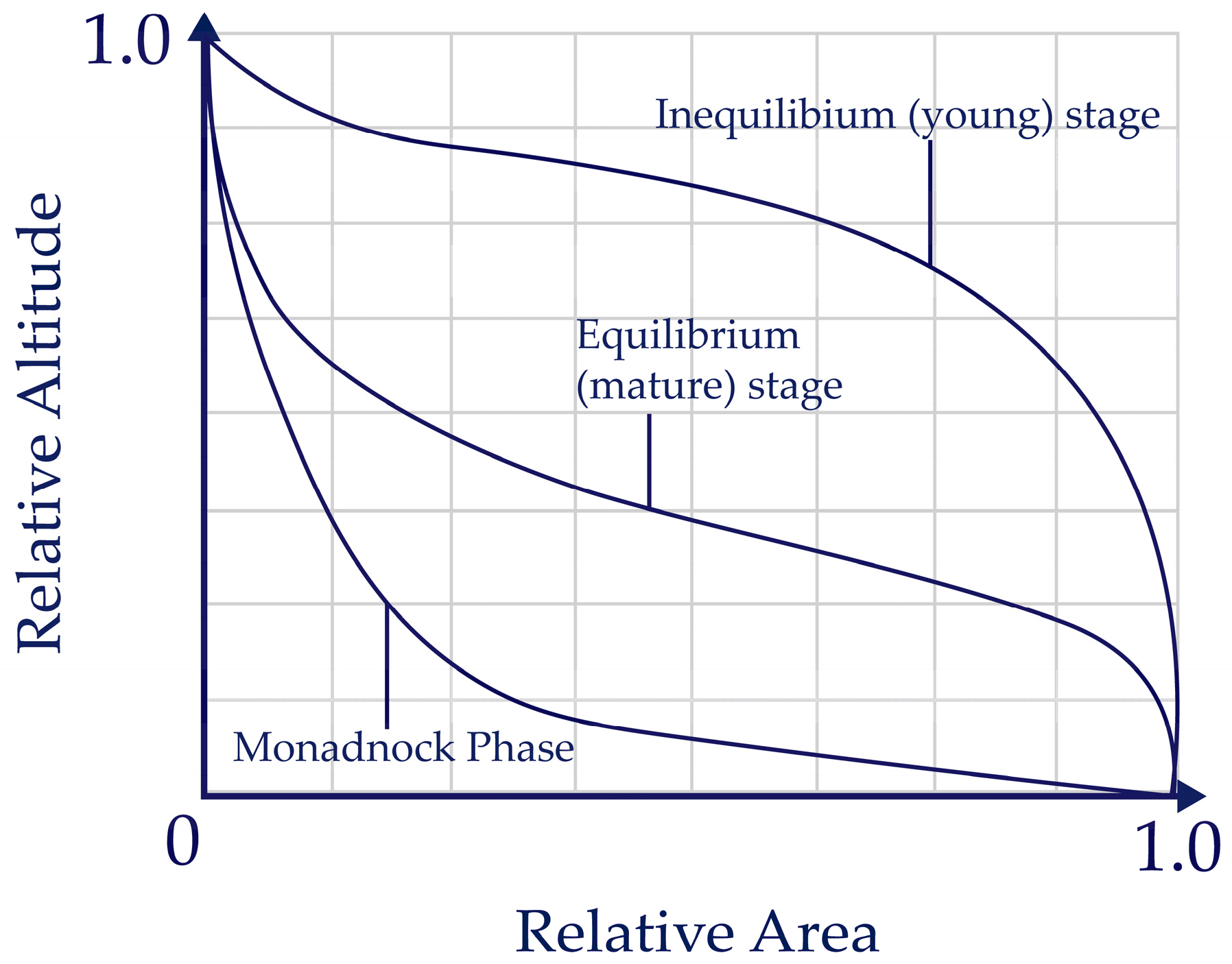
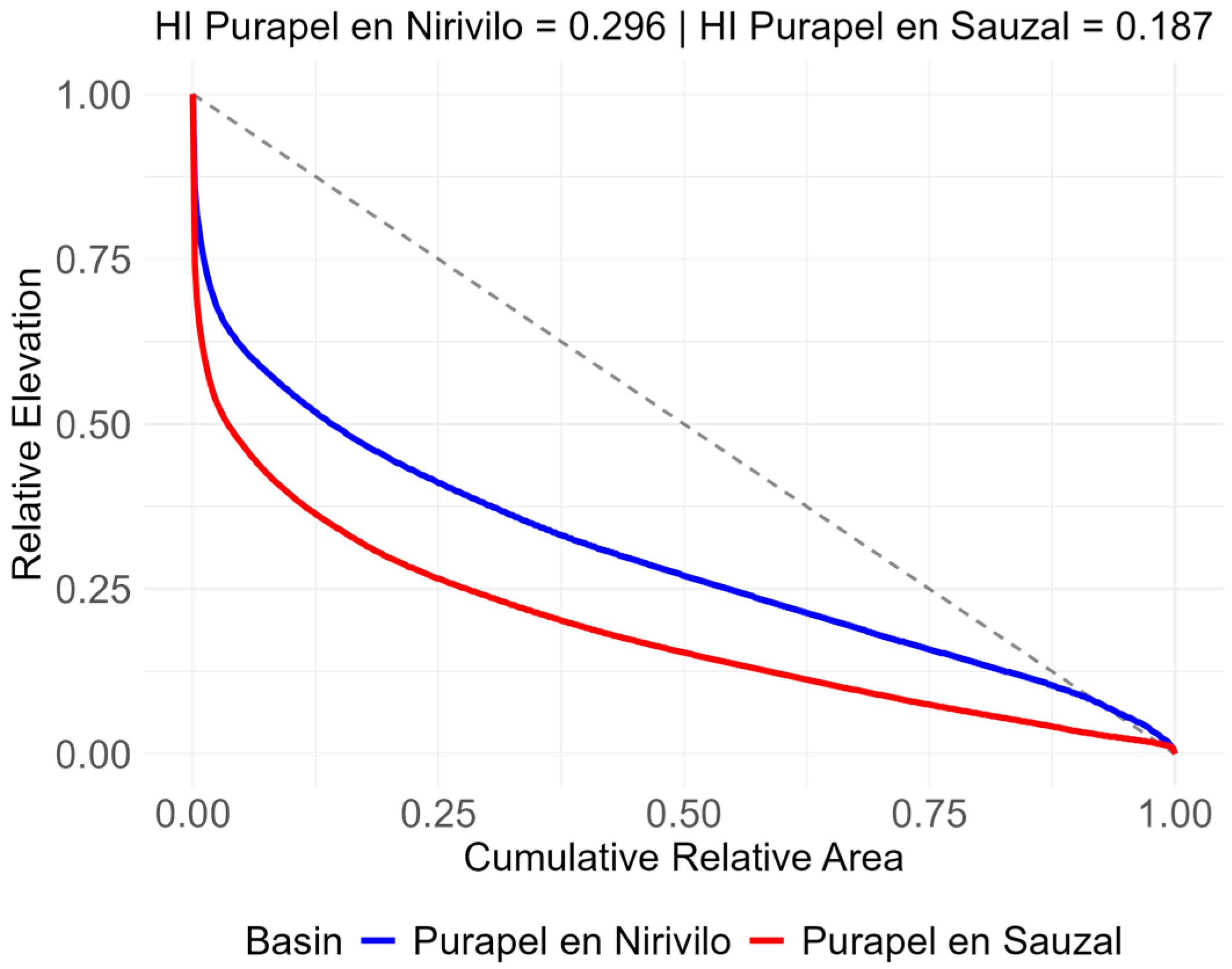
The topographic analysis of the watershed was performed through evaluation of mean slope, hypsometric curve, and hypsometric integral (HI) [47,48] of the Purapel en Nirivilo (subwatershed of Purapel in Sauzal) and Purapel in Sauzal watersheds. These parameters were calculated using QGIS 3.42.3 [49] and R 4.4.2 [50] software, with ALOS PALSAR digital elevation models. The hypsometric curve (Figure 4) of a watershed is the graphic representation of the relative area of the watershed located above or below a given elevation [51,52]. Convex curves characterize young basins with low erosion levels, in which most of the solid material remains within the basin; S-shaped curves correspond to mature basins with an intermediate degree of erosion; and concave curves indicate old, highly eroded basins [51,52].
Strahler [51], points out that based on their hypsometric curve, basins can be classified into three types (Equation (2)): monadnock (HI < 0.3), mature (0.3 ≤ HI ≤ 0.6), and young (HI ≥ 0.6). It also indicates that the value of the hypsometric integral (HI) represents the fraction of solid material that remains within the basin; for example, a HI of 0.3 means that approximately one-third of the material remains in the basin [51]. In other words, this classification is related to the sediment emission of a basin, being greater in geologically younger basins [53].
H I = H m e a n H m i n H m a x H m i n

2.2.3. Vegetation Cover

The Enhanced Vegetation Index (EVI) is an indicator of vegetation greenness [54] and has a high correlation with the amount of chlorophyll and the leaf area of forest stands [55,56,57]; it is used to monitor the vigor and health of plant masses [58]. This index has the advantage of reducing the influence of soil and atmosphere on its estimates. Its range is between −1 and 1, and values above 0.2 are considered vegetation cover [54]. Post-fire vegetation recovery was analyzed using EVI, calculated from Sentinel-2 images and corresponding to the 2017–2018 period. Calculations were done using Equation (3), where NIR is Near Infrared, RED is Red band, and BLUE is Blue band.
E V I = 2.5 × N I R R E D N I R + 6 × R E D 7.5 × B L U E + 1

2.3. Statistical Analysis

The analysis of the impact of wildfires on sediment load was initially carried out through an annual descriptive analysis of data from the Purapel station in Sauzal. For this purpose, the dispersion of sediment load data corresponding to the period between 1985 and 2018 was plotted to verify whether the distribution of annual sediments has varied.
To analyze the sediment rating curves, a power law model was fitted to the daily, for each, following the work by Warrick [59] (Equation (4)). This model, was chosen as it best represents the temporal trends of the sediment rating curves [59]. Moreover, the model fitting was performed in Python 3.13.0 using the scipy.stats.linregress function from the SciPy library [60]. A linearized version of Equation (4) was used, taking the logarithm of both sides (Equation (5)). The linregress function was then used to calculate a simple linear least squares fit to the transformed data.
C = b 0 Q Q g m b 1
l o g ( C ) = l o g ( b 0 ) + b 1 l o g Q Q g m          
where b0, b1 are coefficients from the model and Qgm the geometric mean of the streamflow (Q). The fitted coefficients b0 and b1 for each year were obtained by exponentiating the intercept and slope, respectively, of the linear fit. These coefficients were tabulated to assess the inter-annual variability and trends in the sediment rating curves.
The calculated coefficients were then evaluated with the Mann–Kendall test (Equations (6)–(9)), to verify the presence of a trend [61,62,63,64] in the model coefficients.
S = k = 1 n 1 j = k + 1 n s g n ( x j x k )
The sign function sgn (xj xk) takes the values shown in Equation (7), where xj and xk are sequential values in the data series. The Mann–Kendall variance, VAR(S) is estimated by means of Equation (8). The results are then normalized with Z, the calculation of which depends on whether S is positive or negative, using Equation (9). Additionally, the annual trend in sediment production was calculated, expressed in tons per year. To do this, we used daily sediment production data in kilograms recorded by the DGA, which was converted to tons per year, considering only years with at least 256 days of data.
To complement the analysis of the trend behavior of sediment load, principal components (PCA) were calculated between daily sediment production, streamflow, and precipitation, while the Quantile-Kendall (QKendall) test was applied to identify quantiles that present significant trends [65,66].
s g n x j x k = 1             i f   x j x k > 0 0             i f   x j x k = 0 1       i f   x j x k < 0
V A R S = 1 18 [ n n 1 2 n + 5 p = 1 q t p t p 1 ( 2 t p + 5 ) ]
Z = S 1 V A R S   ;   i f   S > 0 0                                       ;     i f   S = 0 S + 1 V A R ( S )       ;   i f   S < 0
Finally, an Analysis of Covariance (ANCOVA) was conducted to evaluate the influence of wildfires on sediment production in the watershed while controlling for hydrological variability (Equation (10)). The model examined sediment concentration as the dependent variable, with a binary fire period indicator (0 = pre-fire, 1 = post-fire), streamflow discharge, and precipitation as predictors. The inclusion of streamflow discharge, and precipitation as covariates isolates the fire’s independent effect by accounting for concurrent changes in climatic conditions that also influence sediment load. The fire effect coefficient represents the change in sediment concentration attributable to the fire independent of hydrological variations, with statistical significance assessed at α = 0.05 using Type II sums of squares, this was performed using the Python 3.13.0 Statsmodels package [67].
C m g   L 1 ~ b 0 + b 1 f i r e   p e r i o d   + b 2 Q   ( m 3 s 1 ) + b 3 P p ( m m ) + ε i

3. Results

3.1. Analysis of Burned Areas

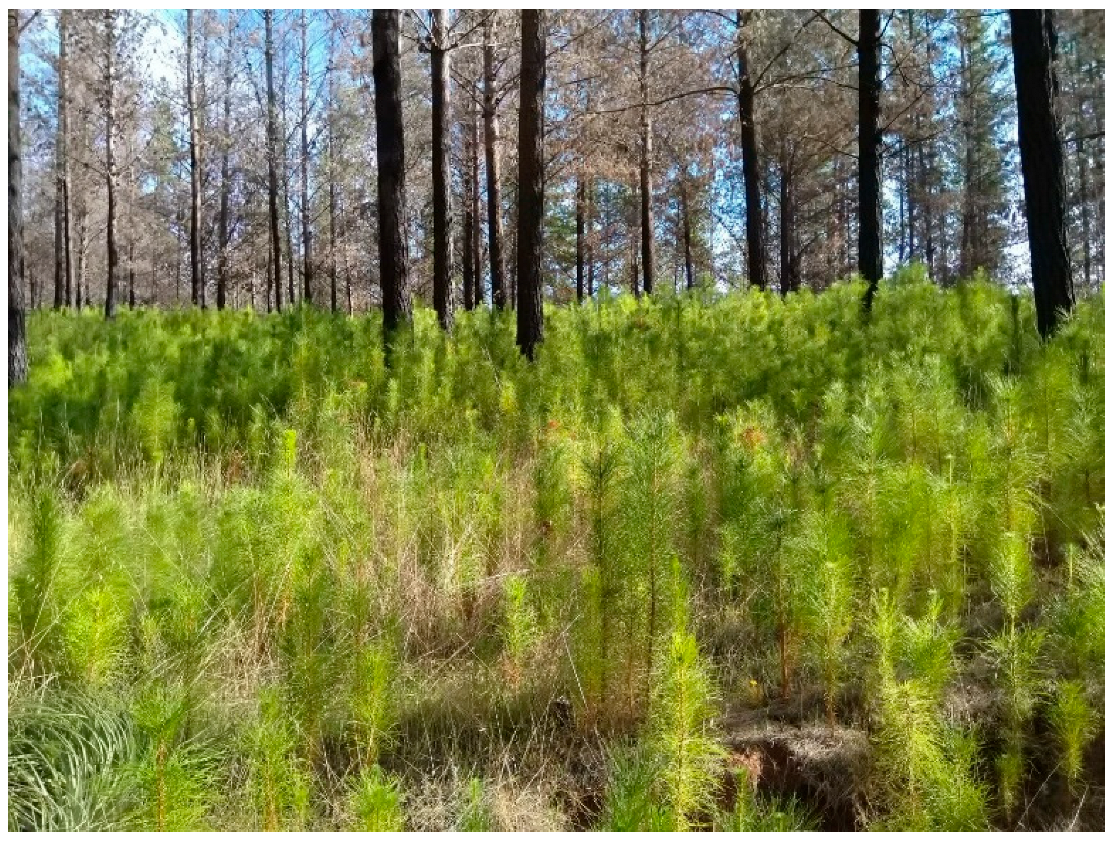
The analysis of the watershed’s surface after the 2016–2017 wildfire season reveals a notable increase in vegetative growth, dominated mainly by pine seedlings (Table 1). Even though a seedling inventory was not performed, personnel from the National Forestry Corporation (Conaf) confirmed that pine seedlings were extremely abundant in the entire burned areas previously occupied by adult Pinus radiata plantations (Figure 5).

3.2. Precipitation and Streamflow Analysis

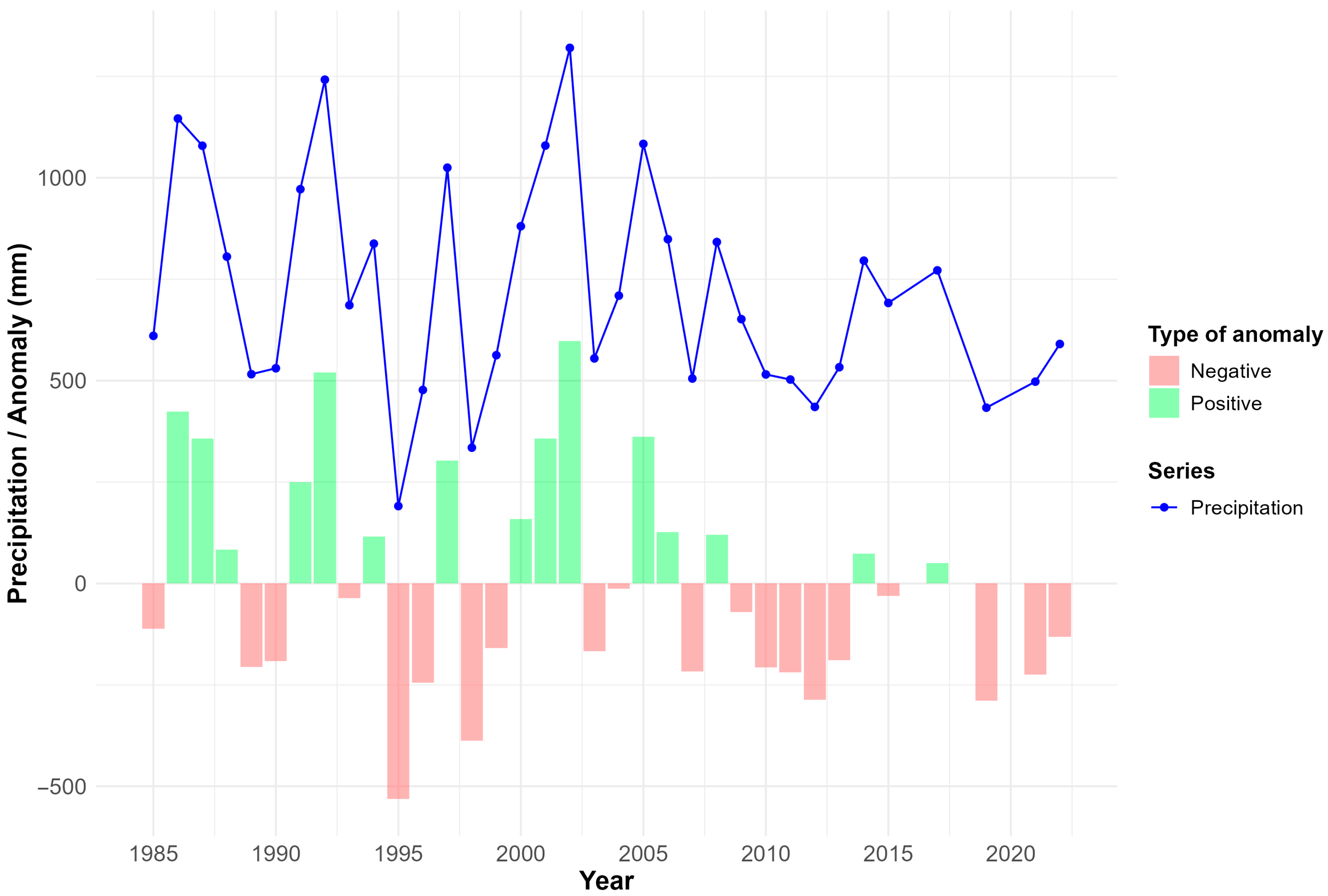
In general terms, a decrease in precipitation is observed in the Purapel in Sauzal watershed, although this trend is not statistically significant (Z = −0.21). Negative anomalies have been more frequent during the last decade, being 2014 and 2017 an exception with positive anomalies (Figure 6).
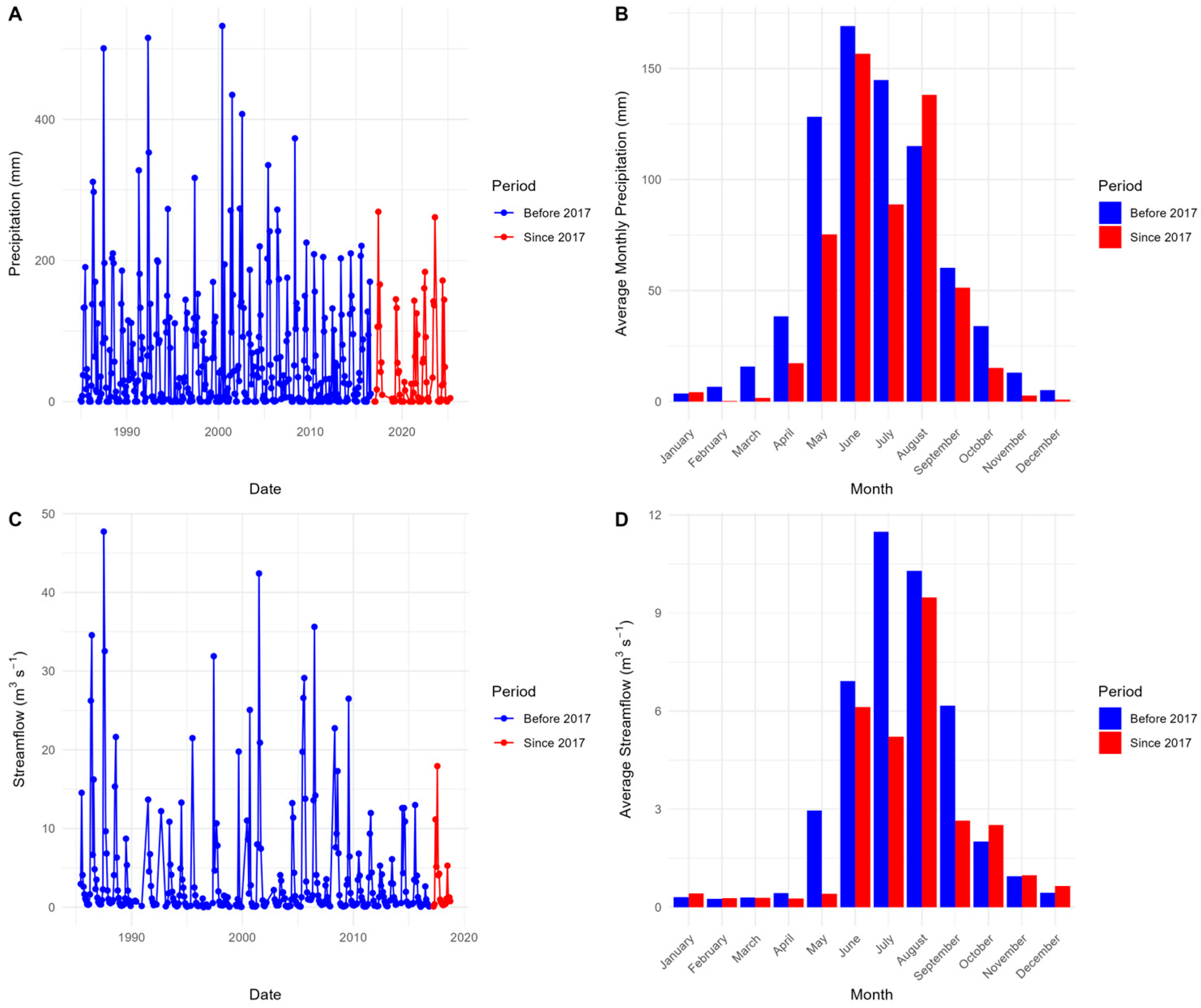
Likewise, the analysis of the daily precipitation time series shows a sustained decrease in rainfall amounts, which is reflected in a reduction in the circulating flow exiting the watershed as the area responds mainly to a pluvial regime (Figure 6) [68,69]. However, shortly after the megafire burned (winter of 2017), the watershed evidenced significant precipitation events that increased flows (Figure 7).

3.3. Hypsometric Curves

The hypsometric analysis verified that both analyzed watersheds are monadnock watersheds, with HI values less than 0.3 (Figure 8).

3.4. EVI Analysis

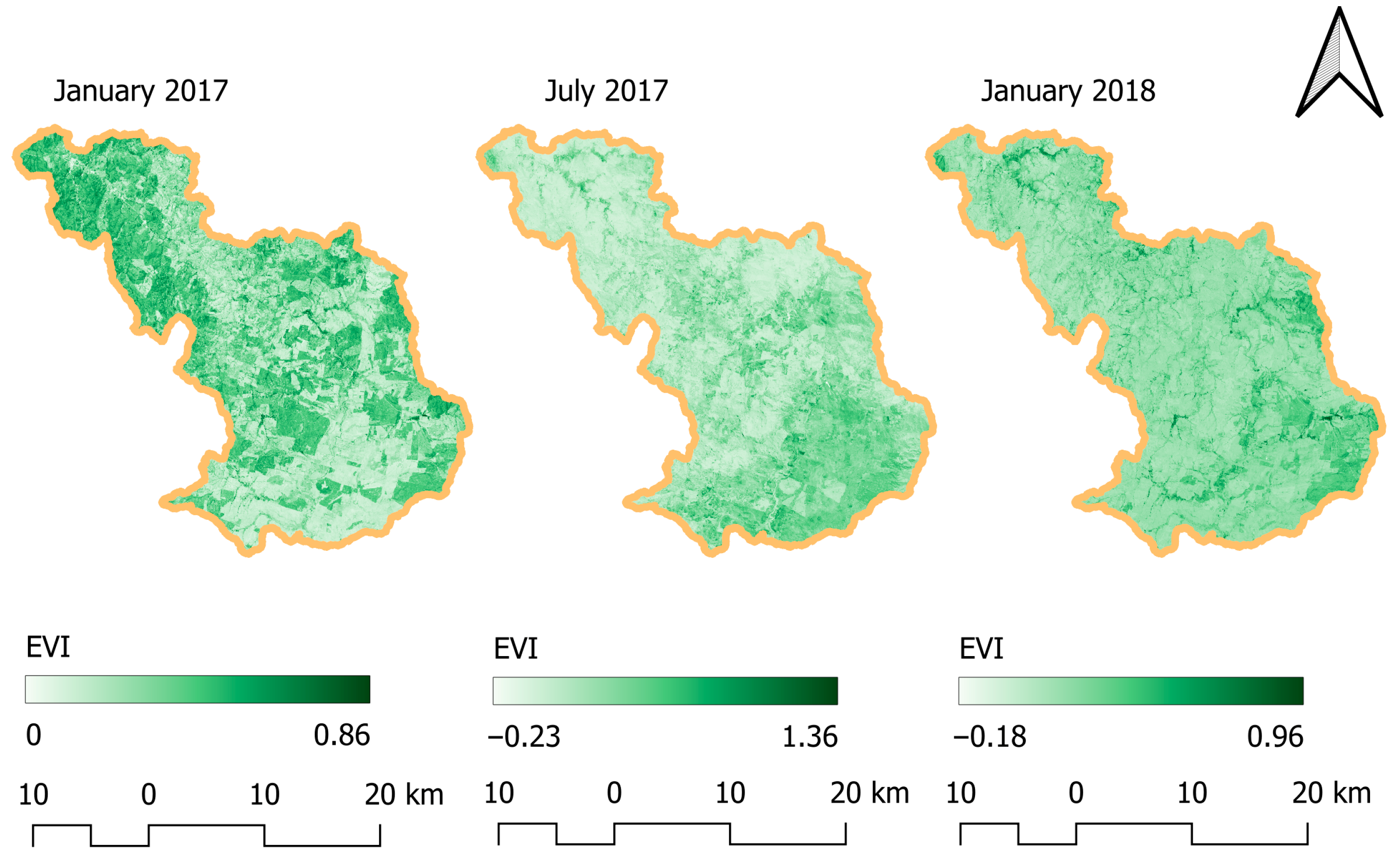
The temporal analysis of EVI reveals an initial decline in vegetation after the wildfire, followed by a progressive recovery of vegetation cover within the watershed (Figure 9).

3.5. Descriptive Analysis of Sediment Load

No significant variation is observed in average sediment concentration per year during the study period, considering both winter and summer values (Figure 10).

3.6. C(Q) Model Fitting

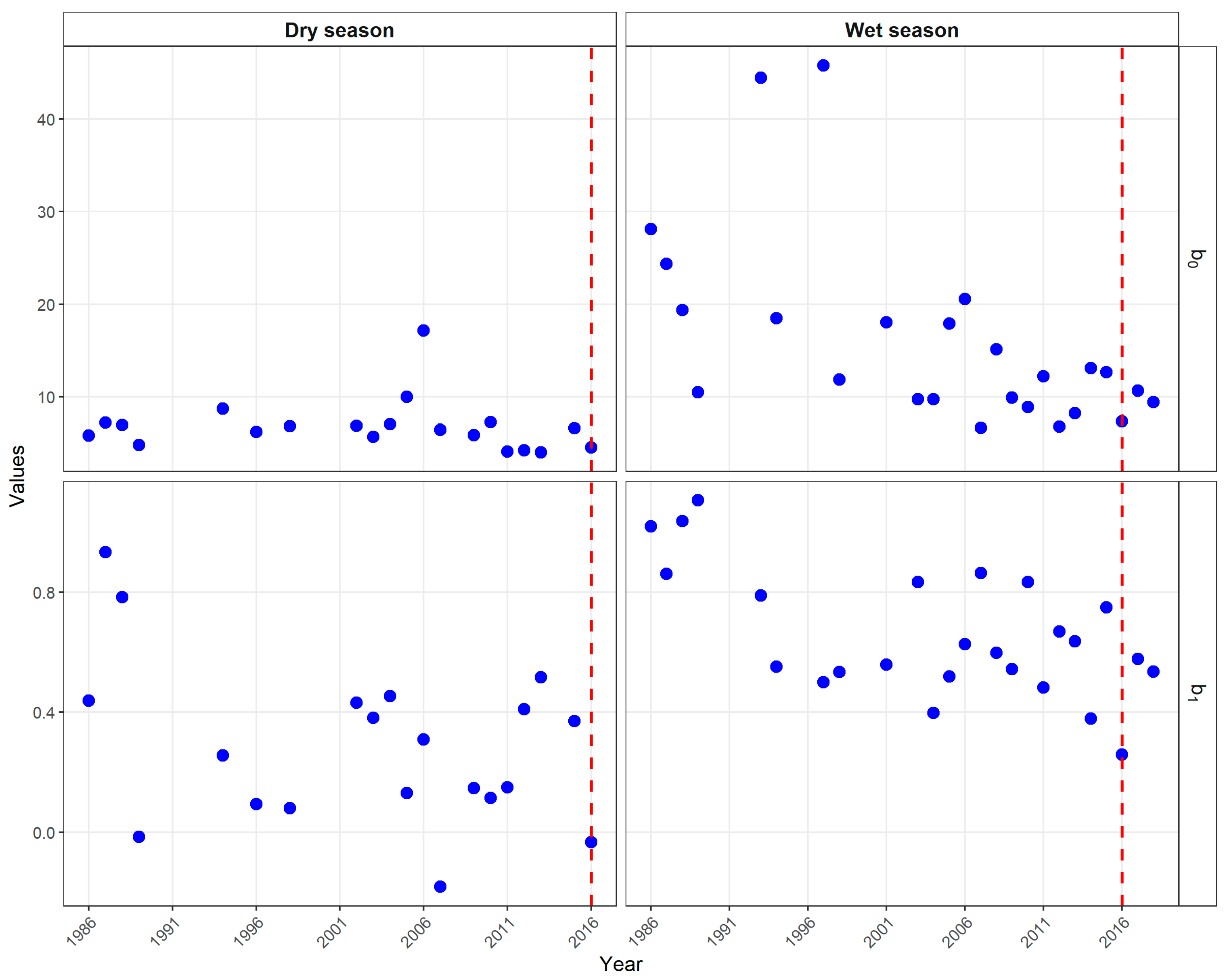
When fitting the model, a decreasing trend is observed in its b0 coefficient, being it more pronounced in the winter season (Figure 11).

3.7. Sediment Load Trends

The Mann–Kendall test results show a negative trend in the values of both coefficients; however, this variation is only significant in winter (Table 2).
The results of the analysis of sediment production by season and annually (ton/year) show a decrease in sediment emissions from the basin (Figure 12) with significant trends in the wet and annual periods.
Moreover, the QKendall test indicates a non-significant variation in PCA1 in summer or in values below the median of the winter period. However, the results shows a significant decrease (p < 0.05) in quantiles above the median (Figure 13).
The Ancova result shows a downward trend after the fire (−30%); however, this result is not significant (p = 0.15), thus ruling out a statistically significant change in sediment production.

4. Discussion

Contrary to our hypothesis, the 2017 megafire did not result in increased sediment production in the Purapel watershed. Annual sediment concentrations showed no significant change following the megafire (Figure 10 and Figure 12), and trend analysis revealed a significant decrease in winter sediment production over the study period, while for the dry period a negative slope is observed (Figure 12), although not significant. These unexpected findings suggest the need to examine the interacting factors that may have prevented the anticipated erosion response.
The Purapel watershed possesses inherently erodible soils derived from weathered parent material [69]. When vegetation is removed, these soils typically exhibit rapid erosion responses to intense rainfall [10,70,71,72]. The 2017 wildfire affected approximately 520,000 hectares (78% of the watershed), creating conditions that should have promoted severe erosion and sediment load, particularly given that the burned area consisted almost entirely of Pinus radiata monocultures (Figure 2).
The timing of the fire events also coincided with unusual climatic conditions. Although 2017 fell within the central Chile megadrought period (2010–2019) [73], it recorded the highest annual precipitation of the decade (Figure 6 and Figure 7). This precipitation concentrated between April and October, and fell on recently burned soils during the typically erosive winter season [73,74,75]. The combination of extensive bare soil and above-average rainfall for the drought period should have triggered substantial detachment of soil particles and, therefore, large amounts of sediment load.
There are potentially several watershed characteristics which may have moderated the erosion response. Hypsometric analysis reveals a geomorphologically mature system (HI < 0.3), indicating equilibrium between erosive forces and resistance factors [76,77]. The predominant sandy clay loam soils in lower elevations exhibit low erodibility [78,79], while the more erodible loam soils are confined to upper watershed areas (Figure 3). This spatial distribution of soil types may have limited sediment delivery to stream channels, or to where water samples were collected [10,69].
The most compelling explanation for the marginal erosion response lies in the rapid post-fire vegetation recovery. Pinus radiata, adapted to fire-prone ecosystems, has already been demonstrated to show remarkable regeneration capacities [26]. The dNBR analysis documented a four-fold increase in enhanced regrowth areas between 2017 (861 ha) and 2018 (3501 ha), while areas classified as low to moderate-low severity decreased from 24,427 to 15,375 hectares, indicating widespread recovery (Table 1). The Enhanced Vegetation Index analysis supports this pattern, showing sustained recovery throughout 2017–2018 despite the initial dramatic decline (Figure 9). Even though a seedling inventory was not performed, Government agencies and our research team confirmed the large quantity of pine seedlings present in the study area, as shown in Figure 5. Likewise, a study carried out by González et al. [80] determined that the regeneration density of Pinus radiata in the coastal area of the Maule region (post-fire 2017) ranges between 1600 and 15,000 plants per hectare, with regeneration being predominant in areas that suffered a high intensity of damage from the fire.
This massive seedling establishment likely provided critical soil protection during the vulnerable post-fire period. Previous research has demonstrated that even sparse vegetation can significantly reduce erosion rates [10]. For example, changes in soil erosion caused by wildfires in the Pinios reservoir basin (western Greece) were analyzed using RUSLE in a GIS (Arc map) tools, highlighting the influence of the cover factor over different time periods [81].
The rapid germination effectively armored exposed soils before winter rains could generate substantial erosion, explaining the absence of increased sediment loads [82,83]. In this context, Follmi et al. [84] studied the effect of plant regeneration on sediment production in a watershed in northern Portugal, finding that rapid germination effectively protected exposed soils, decreasing the watershed’s sediment production by up to 84% in the years following the fire.
Several authors (e.g., [85,86]) have studied the potential use of afforestation as a watershed restoration technique, thereby achieving soil stabilization on the one hand and generating potential economic profit by selling the wood generated on the other. In this area, Rodrigues [85] evaluated a management scheme for forest plantations using linear programming models, prioritizing soil protection and allowing for wood harvesting. This approach can be replicated in Chile, particularly in areas that have lost vegetation due to forest fires. However, the broader context of the megadrought cannot be ignored. Reduced precipitation throughout the 2010s diminished stream power and sediment transport capacity [73,75]. As a purely pluvial system without snowmelt contributions [87], the Purapel watershed’s sediment dynamics are directly coupled to rainfall patterns. The decade-long reduction in precipitation may have progressively depleted available sediment sources, contributing to the observed declining trend in winter sediment production [69].
The Ancova shows no statistically significant differences (p > 0.05) in sediment production between the pre-fire and post-fire periods; that is, there are no instantaneous increases in post-fire sediment production. Even though the majority of research concludes that large wildfires indeed increase sediment production (e.g., [30,88,89]), some authors have documented a decrease in sediment production after an area is burned. This reduction occurs when the initial postfire sediment pulse removes much of the readily erodible material, leaving hillslopes and channels temporarily “supply limited”. After this first flush, sediment loads may drop below pre-fire levels until new material is produced by weathering or slope processes [90]. Moreover, rapid vegetation regrowth can also decrease sediment production, which is hypothesized herein due to evidenced excessive pine seedlings. Grasses, shrubs, or invasive plants often recolonize burned areas within a few years, stabilizing soils and lowering erosion rates. Postfire rehabilitation treatments such as mulching or seeding can accelerate this recovery and further suppress sediment delivery [91]. Finally, channel processes may also contribute to a decrease in sediment concentration. Large postfire sediment inputs can leave behind coarse deposits that armor streambeds, reducing subsequent sediment transport until finer particles accumulate again [92]. In some cases, hydrologic shifts play a role as well. For example, in Mediterranean-type climates, fire-induced water repellency may reduce infiltration but also limit stormflow and sediment load under low-intensity rainfall [93]. Furthermore, Tolorza et al. [94] point out that the reduction in sediments in a basin is mainly due to a decrease in circulating waters in the area and that vegetation would not have a significant effect on this decrease, except by influencing the decrease in water. However, while it is true that flows and precipitation have decreased in the study site, the year of the megafire was particularly rainy and, as a consequence, it is expected to find an increase in flows, a situation that did not occur (Figure 12); our hypothesis was that the regeneration of vegetation does have a positive impact on the control of sediments in this watershed. Additionally, the hydrological stability of the watershed, characterized by mature topography with low hypsometric integral values (HI < 0.3) and predominantly sandy clay loam soils with low erodibility, likely contributed to the resilience against erosive processes.
There have been documented cases where sediment load have decreased after large wildfires, but not immediately after the burning event. For instance, Rengers et al. [95] tracked erosion in the two years following a wildfire using terrestrial lidar in southern California. Initial erosion and channel response were strong, but subsequent storms produced much less erosion, as the sediment supply was depleted and channels became coarser and armored. This led to a decline in erosion over the study period, despite similar storm magnitudes. Likewise, a lidar-based study in 2023 reported that while initial wildfire-activated dry ravel and debris flows removed much of the available sediment, continued erosion later in the season slowed down and catchments became supply-limited, so sediment load dropped substantially after initial events [96]. Therefore, our findings challenge conventional understanding of post-fire erosion in Mediterranean ecosystems. While severe erosion typically follows large fires, the Purapel watershed demonstrated remarkable resilience, possibly through the combination of rapid revegetation (pine seedlings) and some hydrological variables such as climate and water repellency. However, this interpretation remains limited by the cessation of sediment monitoring in 2018, preventing assessment of longer-term trajectories.

Management Implications

The findings from this study have several implications for post-fire watershed management and sediment-control strategies in Mediterranean regions of central Chile and similar environments. The lack of increased sediment production following the 2017 megafire in the Purapel watershed highlights the relevance of considering local geomorphological, climatic, and ecological resilience factors when designing post-fire interventions. In this case, rapid and dense regeneration of Pinus radiata seedlings played a critical role in stabilizing soils during the first post-fire rainy season, suggesting that management approaches should prioritize and facilitate natural or assisted vegetation recovery as an effective erosion-control strategy. Restoration programs could therefore focus on promoting early vegetative cover through the protection of natural regeneration, reseeding, or low-impact planting rather than extensive mechanical treatments that disturb soils. However, more research is needed to determine which approach (or combination of them) are most appropriate for the reality of the region.
Furthermore, the geomorphological maturity of the watershed and the prevalence of low-erodibility soils indicate that not all burned basins require the same intensity of sediment mitigation actions. A site-specific assessment of sediment supply, soil erodibility, and vegetation recovery potential should guide the allocation of post-fire restoration resources. Given the continuing megadrought context, which reduces streamflow and sediment transport capacity, managers should also integrate hydrological monitoring and adaptive management into long-term watershed recovery plans. Overall, these results underscore the need for flexible, evidence-based strategies that move beyond generic assumptions of increased post-fire erosion, emphasizing the combined roles of vegetation dynamics, watershed morphology, and climatic variability in shaping post-fire sediment responses.

5. Conclusions and Recommendations

This analysis does not show an increase in sediment production in the Purapel watershed following the historical 2017 megafire in central Chile, as would be expected based on previous research. On the contrary, the trend tests for sediment production verify a significant decrease during the following winter period. As a first approximation, this is likely due to efficient soil protection in upland areas resulting from the evidenced massive germination of Pinus radiata seedlings, resulting in soil protection and the absence of massive erosive processes downstream, as usually happens after the occurrence of large wildfires in pine plantations.
These findings highlight the complex interactions between climate variability, vegetation dynamics, and geomorphological processes in Mediterranean plantation forests. The results suggest that rapid post-fire regeneration of fire-adapted species can effectively mitigate expected increases in sediment load, even after extensive burning. However, the discontinuation of sediment monitoring in 2018 limits our ability to assess long-term trends and underscores the importance of maintaining continuous hydrological monitoring networks to better understand post-fire watershed responses. Therefore, more research is needed to better evaluate the specific causes of the unusual decrease in sediment production documented in this study, including water repellency, seedlings inventories, and surely more years of data after the event to identify possible trends in sediment load.
Finally, the study contributes to sustainable natural resource management by providing new insights into how Mediterranean forest ecosystems respond to extreme wildfire events, particularly in terms of sediment loads. Most importantly, the research illustrates how managed plantation forests, under those climatic conditions can contribute to soil and water conservation, which is vital for sustainable watershed and river management. It calls attention to the need for adaptive strategies that consider both ecological resilience and local climate trends. By challenging prevailing assumptions and promoting data-driven, ecosystem-specific understanding, this study contributes to the understanding of post-fire sediment dynamics in Mediterranean climates and emphasizes the need for further research on the role of exotic plantation species in watershed protection and recovery processes following large-scale disturbances caused by severe wildfires. Moreover, post-fire management in Mediterranean watersheds should prioritize rapid vegetation recovery as the main strategy to reduce erosion. Protecting and promoting natural regeneration of Pinus radiata or native species can provide effective soil stabilization with minimal intervention, as shown in this investigation. Therefore, restoration efforts should be targeted to areas with steep slopes, high soil erodibility, or delayed regrowth, while avoiding unnecessary mechanical treatments that disturb soils. Continuous monitoring of hydrology and vegetation recovery is recommended to adapt management actions under ongoing drought conditions and climatic variability.

Author Contributions

Conceptualization, R.P., B.I. and A.I.; methodology, A.I., B.I. and R.P.; software, B.I.; validation, J.P., C.U. and E.G.; formal analysis, P.A.G.-C., C.T. and C.S.; investigation, R.P., P.A.G.-C.; resources, R.P.; data curation, B.I., R.B.-O.; writing—original draft preparation, R.P., B.I., A.I.; writing—review and editing, P.A.G.-C., C.T., J.P., C.U. and E.G.; visualization, B.I. and A.I.; supervision, R.P., C.S.; project administration, R.P., C.S.; funding acquisition, R.P. All authors have read and agreed to the published version of the manuscript.

Funding

This research received no external funding.

Institutional Review Board Statement

Not applicable.

Informed Consent Statement

Not applicable.

Data Availability Statement

The original contributions presented in this study are included in the article. Further inquiries can be directed to the corresponding author(s).

Acknowledgments

The authors gratefully acknowledge the support provided by the Center ANID BASAL FB210015 (CENAMAD), as well as the Center for Mining Sustainability (Project 3.1).

Conflicts of Interest

The authors declare no conflicts of interest.

References

  1. Zheng, H.; Chen, F.; Ouyang, Z.; Tu, N.; Xu, W.; Wang, X.; Miao, H.; Li, X.; Tian, Y. Impacts of Reforestation Approaches on Runoff Control in the Hilly Red Soil Region of Southern China. J. Hydrol. 2008, 356, 174–184. [Google Scholar] [CrossRef]
  2. Yu, X.; Wang, H.; Xin, Z.; Lv, X. Effect of Forest on Sediment Yield in North China. Int. Soil Water Conserv. Res. 2013, 1, 58–64. [Google Scholar] [CrossRef]
  3. Quiñonero-Rubio, J.M.; Nadeu, E.; Boix-Fayos, C.; De Vente, J. Evaluation of the Effectiveness of Forest Restoration and Check-Dams to Reduce Catchment Sediment Yield. Land Degrad. Dev. 2016, 27, 1018–1031. [Google Scholar] [CrossRef]
  4. Pizarro, R.; Valdés-Pineda, R.; Garcia-Chevesich, P.A.; Ibáñez, A.; Pino, J.; Scott, D.F.; Neary, D.G.; McCray, J.E.; Castillo, M.; Ubilla, P. The Large-Scale Effect of Forest Cover on Long-Term Streamflow Variations in Mediterranean Catchments of Central Chile. Sustainability 2022, 14, 4443. [Google Scholar] [CrossRef]
  5. Zhang, L.; Wang, J.; Bai, Z.; Lv, C. Effects of Vegetation on Runoff and Soil Erosion on Reclaimed Land in an Opencast Coal-Mine Dump in a Loess Area. CATENA 2015, 128, 44–53. [Google Scholar] [CrossRef]
  6. Ferreira, P.; Van Soesbergen, A.; Mulligan, M.; Freitas, M.; Vale, M.M. Can Forests Buffer Negative Impacts of Land-Use and Climate Changes on Water Ecosystem Services? The Case of a Brazilian Megalopolis. Sci. Total Environ. 2019, 685, 248–258. [Google Scholar] [CrossRef]
  7. Li, G.; Wan, L.; Cui, M.; Wu, B.; Zhou, J. Influence of Canopy Interception and Rainfall Kinetic Energy on Soil Erosion under Forests. Forests 2019, 10, 509. [Google Scholar] [CrossRef]
  8. Zore, A.; Bezak, N.; Šraj, M. The Influence of Rainfall Interception on the Erosive Power of Raindrops under the Birch Tree. J. Hydrol. 2022, 613, 128478. [Google Scholar] [CrossRef]
  9. García-Chevesich, P. Control de la Erosión y Recuperación de Suelos Degradados; Outskirts Press: Parker, CO, USA, 2015; ISBN 978-1-4787-4510-5. [Google Scholar]
  10. Unesco. Antecedentes de La Relación Masa Forestal y Disponibilidad Hídrica En Chile; Documentos Técnicos PHI-VIII; Unesco: Montevideo, Uruguay, 2019. [Google Scholar]
  11. Sidle, R.C.; Ziegler, A.D. The Canopy Interception–Landslide Initiation Conundrum: Insight from a Tropical Secondary Forest in Northern Thailand. Hydrol. Earth Syst. Sci. 2017, 21, 651–667. [Google Scholar] [CrossRef]
  12. Tao, W.; Shao, F.; Su, L.; Wang, Q.; Zhou, B.; Sun, Y. An Analytical Model for Simulating the Rainfall-Interception-Infiltration-Runoff Process with Non-Uniform Rainfall. J. Environ. Manag. 2023, 344, 118490. [Google Scholar] [CrossRef]
  13. Tsiko, C.T.; Makurira, H.; Gerrits, A.M.J.; Savenije, H.H.G. Measuring Forest Floor and Canopy Interception in a Savannah Ecosystem. Phys. Chem. Earth Parts A/B/C 2012, 47–48, 122–127. [Google Scholar] [CrossRef]
  14. Berland, A.; Shiflett, S.A.; Shuster, W.D.; Garmestani, A.S.; Goddard, H.C.; Herrmann, D.L.; Hopton, M.E. The Role of Trees in Urban Stormwater Management. Landsc. Urban Plan. 2017, 162, 167–177. [Google Scholar] [CrossRef]
  15. Jones, J.; Ellison, D.; Ferraz, S.; Lara, A.; Wei, X.; Zhang, Z. Forest Restoration and Hydrology. For. Ecol. Manag. 2022, 520, 120342. [Google Scholar] [CrossRef]
  16. González, M.E.; Lara, A.; Urrutia, R.; Bosnich, J. Cambio Climático y Su Impacto Potencial En La Ocurrencia de Incendios Forestales En La Zona Centro-Sur de Chile (33°–42° S). Bosque 2011, 32, 215–219. [Google Scholar] [CrossRef]
  17. Abatzoglou, J.T.; Williams, A.P. Impact of Anthropogenic Climate Change on Wildfire across Western US Forests. Proc. Natl. Acad. Sci. USA 2016, 113, 11770–11775. [Google Scholar] [CrossRef] [PubMed]
  18. Abatzoglou, J.T.; Battisti, D.S.; Williams, A.P.; Hansen, W.D.; Harvey, B.J.; Kolden, C.A. Projected Increases in Western US Forest Fire despite Growing Fuel Constraints. Commun. Earth Environ. 2021, 2, 227. [Google Scholar] [CrossRef]
  19. Cordero, R.R.; Feron, S.; Damiani, A.; Carrasco, J.; Karas, C.; Wang, C.; Kraamwinkel, C.T.; Beaulieu, A. Extreme Fire Weather in Chile Driven by Climate Change and El Niño–Southern Oscillation (ENSO). Sci. Rep. 2024, 14, 1974. [Google Scholar] [CrossRef]
  20. Úbeda, X.; Sarricolea, P. Wildfires in Chile: A Review. Glob. Planet. Change 2016, 146, 152–161. [Google Scholar] [CrossRef]
  21. Castillo, M.; Plaza, Á.; Garfias, R. A Recent Review of Fire Behavior and Fire Effects on Native Vegetation in Central Chile. Glob. Ecol. Conserv. 2020, 24, e01210. [Google Scholar] [CrossRef]
  22. Klubock, T.M. La Frontera: Forests and Ecological Conflict in Chile’s Frontier Territory; Duke University Press: Durham, NC, USA, 2014; ISBN 978-0-8223-7656-9. [Google Scholar]
  23. Fuentealba, A.; Duran, L.; Morales, N.S. The Impact of Forest Science in Chile: History, Contribution, and Challenges. Can. J. For. Res. 2021, 51, 753–765. [Google Scholar] [CrossRef]
  24. Heilmayr, R.; Echeverría, C.; Fuentes, R.; Lambin, E.F. A Plantation-Dominated Forest Transition in Chile. Appl. Geogr. 2016, 75, 71–82. [Google Scholar] [CrossRef]
  25. Turner, M.G. Disturbance and Landscape Dynamics in a Changing World. Ecology 2010, 91, 2833–2849. [Google Scholar] [CrossRef]
  26. Leal-Medina, C.; Lopatin, J.; Contreras, A.; González, M.E.; Galleguillos, M. Post-Fire Pinus Radiata Invasion in a Threatened Biodiversity Hotspot Forest: A Multi-Scale Remote Sensing Assessment. For. Ecol. Manag. 2024, 561, 121861. [Google Scholar] [CrossRef]
  27. Depountis, N.; Michalopoulou, M.; Kavoura, K.; Nikolakopoulos, K.; Sabatakakis, N. Estimating Soil Erosion Rate Changes in Areas Affected by Wildfires. Int. J. Geo-Inf. 2020, 9, 562. [Google Scholar] [CrossRef]
  28. Thomas, G.; Rosalie, V.; Olivier, C.; Anna Maria, D.G.; Antonio, L.P. Modelling Forest Fire and Firebreak Scenarios in a Mediterranean Mountainous Catchment: Impacts on Sediment Loads. J. Environ. Manag. 2021, 289, 112497. [Google Scholar] [CrossRef]
  29. Robinne, F.; Hallema, D.W.; Bladon, K.D.; Flannigan, M.D.; Boisramé, G.; Bréthaut, C.M.; Doerr, S.H.; Di Baldassarre, G.; Gallagher, L.A.; Hohner, A.K.; et al. Scientists’ Warning on Extreme Wildfire Risks to Water Supply. Hydrol. Process. 2021, 35, e14086. [Google Scholar] [CrossRef]
  30. Mastrolonardo, G.; Castelli, G.; Certini, G.; Maxwald, M.; Trucchi, P.; Foderi, C.; Errico, A.; Marra, E.; Preti, F. Post-Fire Erosion and Sediment Yield in a Mediterranean Forest Catchment in Italy. Int. J. Sediment Res. 2024, 39, 464–477. [Google Scholar] [CrossRef]
  31. De Girolamo, A.M.; Cerdan, O.; Grangeon, T.; Ricci, G.F.; Vandromme, R.; Lo Porto, A. Modelling Effects of Forest Fire and Post-Fire Management in a Catchment Prone to Erosion: Impacts on Sediment Yield. CATENA 2022, 212, 106080. [Google Scholar] [CrossRef]
  32. East, A.E.; Logan, J.B.; Dow, H.W.; Smith, D.P.; Iampietro, P.; Warrick, J.A.; Lorenson, T.D.; Hallas, L.; Kozlowicz, B. Post-Fire Sediment Yield From a Central California Watershed: Field Measurements and Validation of the WEPP Model. Earth Space Sci. 2024, 11, e2024EA003575. [Google Scholar] [CrossRef]
  33. Shakesby, R.A.; Doerr, S.H.; Walsh, R.P.D. The Erosional Impact of Soil Hydrophobicity: Current Problems and Future Research Directions. J. Hydrol. 2000, 231–232, 178–191. [Google Scholar] [CrossRef]
  34. Agbeshie, A.A.; Abugre, S.; Atta-Darkwa, T.; Awuah, R. A Review of the Effects of Forest Fire on Soil Properties. J. For. Res. 2022, 33, 1419–1441. [Google Scholar] [CrossRef]
  35. Asselman, N.E.M. Fitting and Interpretation of Sediment Rating Curves. J. Hydrol. 2000, 234, 228–248. [Google Scholar] [CrossRef]
  36. Li, S.; Yu, X.; Li, Z.; Xu, X.; Ye, Z. Temporal Variations in the Parameters of Sediment Rating Curves in Karst Watersheds. J. Hydrol. 2022, 612, 128274. [Google Scholar] [CrossRef]
  37. Zhang, T.; Li, D.; East, A.E.; Kettner, A.J.; Best, J.; Ni, J.; Lu, X. Shifted Sediment-Transport Regimes by Climate Change and Amplified Hydrological Variability in Cryosphere-Fed Rivers. Sci. Adv. 2023, 9, eadi5019. [Google Scholar] [CrossRef]
  38. Morehead, M.D.; Syvitski, J.P.; Hutton, E.W.H.; Peckham, S.D. Modeling the Temporal Variability in the Flux of Sediment from Ungauged River Basins. Glob. Planet. Change 2003, 39, 95–110. [Google Scholar] [CrossRef]
  39. Yang, G.; Chen, Z.; Yu, F.; Wang, Z.; Zhao, Y.; Wang, Z. Sediment Rating Parameters and Their Implications: Yangtze River, China. Geomorphology 2007, 85, 166–175. [Google Scholar] [CrossRef]
  40. Wang, J.; Ishidaira, H.; Sun, W.; Ning, S. Development and Interpretation of New Sediment Rating Curve Considering the Effect of Vegetation Cover for Asian Basins. Sci. World J. 2013, 2013, 154375. [Google Scholar] [CrossRef] [PubMed]
  41. Sarricolea, P.; Herrera-Ossandon, M.; Meseguer-Ruiz, Ó. Climatic Regionalisation of Continental Chile. J. Maps 2017, 13, 66–73. [Google Scholar] [CrossRef]
  42. Galleguillos, M.; Dinamarca, D.; Seguel, O.; Faundez, C. CLSoilMaps: A National Soil Gridded Product for Chile [Data Set]. In Earth Science System Data (Versión V1). Zenodo. 2022. Available online: https://zenodo.org/records/7464210 (accessed on 27 March 2025). [CrossRef]
  43. Gibson, R.; Danaher, T.; Hehir, W.; Collins, L. A Remote Sensing Approach to Mapping Fire Severity in South-Eastern Australia Using Sentinel 2 and Random Forest. Remote Sens. Environ. 2020, 240, 111702. [Google Scholar] [CrossRef]
  44. Gale, M.G.; Cary, G.J.; Yebra, M.; Leavesley, A.J.; Van Dijk, A.I.J.M. Comparison of Contrasting Optical and LiDAR Fire Severity Remote Sensing Methods in a Heterogeneous Forested Landscape in South-Eastern Australia. Int. J. Remote Sens. 2022, 43, 2538–2559. [Google Scholar] [CrossRef]
  45. Faúndez Pinilla, J.; Castillo Soto, M.; Navarro Cerrillo, R.M. Impactos de Los Incendios Forestales de Magnitud En Áreas Silvestres Protegidas de Chile Central. Bosque 2023, 44, 83–95. [Google Scholar] [CrossRef]
  46. Zennir, R.; Khallef, B. Forest Fire Area Detection Using Sentinel-2 Data: Case of the Beni Salah National Forest—Algeria. J. For. Sci. 2023, 69, 33–40. [Google Scholar] [CrossRef]
  47. Pike, R.J.; Wilson, S.E. Elevation-Relief Ratio, Hypsometric Integral, and Geomorphic Area-Altitude Analysis. Geol. Soc. Am. Bull. 1971, 82, 1079. [Google Scholar] [CrossRef]
  48. Maliqi, E.; Kumar, N.; Latifi, L.; Singh, S. Soil Erosion Estimation Using an Empirical Model, Hypsometric Integral and Geo-Information Science—A Case Study. Ecol. Eng. Environ. Technol. 2023, 24, 62–72. [Google Scholar] [CrossRef]
  49. QGIS Development Team. QGIS Geographic Information System. 2024. Available online: https://www.qgis.org (accessed on 27 March 2025).
  50. R Core Team. R: A Language and Environment for Statistical Computing. 2024. Available online: https://www.R-project.org/ (accessed on 27 March 2025).
  51. Strahler, A.N. Hypsometric (Area-Altitude) Analysis of Erosional Topography. Geol. Soc. Am. Bull. 1952, 63, 1117. [Google Scholar] [CrossRef]
  52. Pedrera, A.; Pérez-Peña, J.V.; Galindo-Zaldívar, J.; Azañón, J.M.; Azor, A. Testing the Sensitivity of Geomorphic Indices in Areas of Low-Rate Active Folding (Eastern Betic Cordillera, Spain). Geomorphology 2009, 105, 218–231. [Google Scholar] [CrossRef]
  53. Kadlag, R.B.; Pawase, P.P.; Gatkal, N.R.; Khurdal, J.K.; Nalawade, S.M. Hypsometric Analysis of Watershed Using Geographical Information System. JART 2022, 47, 239–242. [Google Scholar] [CrossRef]
  54. Bari, E.; Nipa, N.J.; Roy, B. Association of Vegetation Indices with Atmospheric & Biological Factors Using MODIS Time Series Products. Environ. Chall. 2021, 5, 100376. [Google Scholar] [CrossRef]
  55. Gurung, R.B.; Breidt, F.J.; Dutin, A.; Ogle, S.M. Predicting Enhanced Vegetation Index (EVI) Curves for Ecosystem Modeling Applications. Remote Sens. Environ. 2009, 113, 2186–2193. [Google Scholar] [CrossRef]
  56. Gerard, F.F.; George, C.T.; Hayman, G.; Chavana-Bryant, C.; Weedon, G.P. Leaf Phenology Amplitude Derived from MODIS NDVI and EVI: Maps of Leaf Phenology Synchrony for Meso- and South America. Geosci. Data J. 2020, 7, 13–26. [Google Scholar] [CrossRef]
  57. De, A.; Sahani, N.; Datta, A.; Maitra, A. Spatiotemporal Analysis of Different Vegetation Indices and Relation to Meteorological Parameters over a Tropical Urban Location and Its Surroundings. ATM 2024, 38, 911–934. [Google Scholar] [CrossRef]
  58. Crespo-Antia, J.P.; Gazol, A.; Pizarro, M.; González De Andrés, E.; Valeriano, C.; Rubio Cuadrado, Á.; Linares, J.C.; Camarero, J.J. Matching Vegetation Indices and Tree Vigor in Pyrenean Silver Fir Stands. Remote Sens. 2024, 16, 4564. [Google Scholar] [CrossRef]
  59. Warrick, J.A. Trend Analyses with River Sediment Rating Curves. Hydrol. Process. 2015, 29, 936–949. [Google Scholar] [CrossRef]
  60. Virtanen, P.; Gommers, R.; Oliphant, T.E.; Haberland, M.; Reddy, T.; Cournapeau, D.; Burovski, E.; Peterson, P.; Weckesser, W.; Bright, J.; et al. SciPy 1.0: Fundamental Algorithms for Scientific Computing in Python. Nat. Methods 2020, 17, 261–272. [Google Scholar] [CrossRef]
  61. Mann, H.B. Nonparametric Tests Against Trend. Econometrica 1945, 13, 245. [Google Scholar] [CrossRef]
  62. Yue, S.; Pilon, P.; Cavadias, G. Power of the Mann–Kendall and Spearman’s Rho Tests for Detecting Monotonic Trends in Hydrological Series. J. Hydrol. 2002, 259, 254–271. [Google Scholar] [CrossRef]
  63. Sangüesa, C.; Pizarro, R.; Ibañez, A.; Pino, J.; Rivera, D.; García-Chevesich, P.; Ingram, B. Spatial and Temporal Analysis of Rainfall Concentration Using the Gini Index and PCI. Water 2018, 10, 112. [Google Scholar] [CrossRef]
  64. Sangüesa, C.; Pizarro, R.; Ingram, B.; Balocchi, F.; García-Chevesich, P.; Pino, J.; Ibáñez, A.; Vallejos, C.; Mendoza, R.; Bernal, A.; et al. Streamflow Trends in Central Chile. Hydrology 2023, 10, 144. [Google Scholar] [CrossRef]
  65. Yu, G.; Wright, D.B.; Zhu, Z.; Smith, C.; Holman, K.D. Process-Based Flood Frequency Analysis in an Agricultural Watershed Exhibiting Nonstationary Flood Seasonality. Hydrol. Earth Syst. Sci. 2019, 23, 2225–2243. [Google Scholar] [CrossRef]
  66. Rodgers, K.; Roland, V.; Hoos, A.; Crowley-Ornelas, E.; Knight, R. An Analysis of Streamflow Trends in the Southern and Southeastern US from 1950–2015. Water 2020, 12, 3345. [Google Scholar] [CrossRef]
  67. Seabold, S.; Perktold, J. Statsmodels: Econometric and Statistical Modeling with Python. In Proceedings of the 9th Python in Science Conference, Austin, TX, USA, 28 June–3 July 2010; pp. 57–61. [Google Scholar] [CrossRef]
  68. Alvarez-Garreton, C.; Mendoza, P.A.; Boisier, J.P.; Addor, N.; Galleguillos, M.; Zambrano-Bigiarini, M.; Lara, A.; Puelma, C.; Cortes, G.; Garreaud, R.; et al. The CAMELS-CL Dataset: Catchment Attributes and Meteorology for Large Sample Studies—Chile Dataset. Hydrol. Earth Syst. Sci. 2018, 22, 5817–5846. [Google Scholar] [CrossRef]
  69. Pizarro, R.; García-Chevesich, P.; Pino, J.; Ibáñez, A.; Pérez, F.; Flores, J.P.; Sharp, J.O.; Ingram, B.; Mendoza, R.; Neary, D.G.; et al. Stabilization of Stage–Discharge Curves Following the Establishment of Forest Plantations: Implications for Sediment Production. River Res. Appl. 2020, 36, 1828–1837. [Google Scholar] [CrossRef]
  70. Buendia, C.; Bussi, G.; Tuset, J.; Vericat, D.; Sabater, S.; Palau, A.; Batalla, R.J. Effects of Afforestation on Runoff and Sediment Load in an Upland Mediterranean Catchment. Sci. Total Environ. 2016, 540, 144–157. [Google Scholar] [CrossRef] [PubMed]
  71. López-Vicente, M.; Nadal-Romero, E.; Cammeraat, E.L.H. Hydrological Connectivity Does Change Over 70 Years of Abandonment and Afforestation in the Spanish Pyrenees. Land Degrad. Dev. 2017, 28, 1298–1310. [Google Scholar] [CrossRef]
  72. Nadal-Romero, E.; Llena, M.; Cortijos-López, M.; Lasanta, T. Afforestation after Land Abandonment as a Nature-Based Solution in Mediterranean Mid-Mountain Areas: Implications and Research Gaps. Curr. Opin. Environ. Sci. Health 2023, 34, 100481. [Google Scholar] [CrossRef]
  73. Garreaud, R.D.; Boisier, J.P.; Rondanelli, R.; Montecinos, A.; Sepúlveda, H.H.; Veloso-Aguila, D. The Central Chile Mega Drought (2010–2018): A Climate Dynamics Perspective. Int. J. Clim. 2020, 40, 421–439. [Google Scholar] [CrossRef]
  74. Álamos, N.; Alvarez-Garreton, C.; Muñoz, A.; González-Reyes, Á. The Influence of Human Activities on Streamflow Reductions during the Megadrought in Central Chile. Hydrol. Earth Syst. Sci. 2024, 28, 2483–2503. [Google Scholar] [CrossRef]
  75. Garreaud, R.D.; Alvarez-Garreton, C.; Barichivich, J.; Boisier, J.P.; Christie, D.; Galleguillos, M.; LeQuesne, C.; McPhee, J.; Zambrano-Bigiarini, M. The 2010–2015 Megadrought in Central Chile: Impacts on Regional Hydroclimate and Vegetation. Hydrol. Earth Syst. Sci. 2017, 21, 6307–6327. [Google Scholar] [CrossRef]
  76. Farhan, Y.; Elgaziri, A.; Elmaji, I.; Ali, I. Hypsometric Analysis of Wadi Mujib-Wala Watershed (Southern Jordan) Using Remote Sensing and GIS Techniques. Int. J. Geo-Inf. 2016, 7, 158–176. [Google Scholar] [CrossRef]
  77. Méndez-Gutiérrez, A.G.; Corral-Rivas, S.; Nájera-Luna, J.A.; Cruz-Cobos, F.; Pompa-García, M. Análisis Morfométrico de La Cuenca El Salto, Durango, México. Terra 2021, 39, e64. [Google Scholar] [CrossRef]
  78. Vaezi, A.R.; Hasanzadeh, H.; Cerdà, A. Developing an Erodibility Triangle for Soil Textures in Semi-Arid Regions, NW Iran. CATENA 2016, 142, 221–232. [Google Scholar] [CrossRef]
  79. Baruah, S.; Kumaraperumal, R.; Kannan, B.; Ragunath, K.; Backiyavathy, M. Soil Erodibility Estimation and Its Correlation with Soil Properties in Coimbatore District. Int. J. Chem. Stud. 2019, 7, 3327–3332. [Google Scholar]
  80. González, M.E.; Galleguillos, M.; Lopatin, J.; Leal, C.; Becerra-Rodas, C.; Lara, A.; San Martín, J. Surviving in a Hostile Landscape: Nothofagus Alessandrii Remnant Forests Threatened by Mega-Fires and Exotic Pine Invasion in the Coastal Range of Central Chile. Oryx 2023, 57, 228–238. [Google Scholar] [CrossRef]
  81. Depountis, N.; Vidali, M.; Kavoura, K.; Nikolaos, S. Soil Erosion Prediction at the Water Reservoir’s Basin of Pineios Dam, Western Greece, Using the Revised Universal Soil Loss Equation. Wseas Trans. Environ. Dev. 2018, 14, 457–463. [Google Scholar]
  82. Gómez, P.; Hahn, S. Post-Fire Regeneration of Woody Species in Pinus radiata D. Don Plantations, Coastal Zone, Maule Region, Central Chile. Gayana Botánica 2017, 74, 302–306. [Google Scholar] [CrossRef]
  83. Becerra, P.I.; Figueroa, C.; Meza, A. Dinámica Post-Incendio de La Vegetación En La Localidad de Rastrojos, Chile Central. Gayana Bot. 2022, 79, 10–26. [Google Scholar] [CrossRef]
  84. Follmi, D.; Baartman, J.; Benali, A.; Nunes, J.P. How Do Large Wildfires Impact Sediment Redistribution over Multiple Decades? Earth Surf. Process. Landf. 2022, 47, 3033–3050. [Google Scholar] [CrossRef]
  85. Rodrigues, A.R.; Marques, S.; Botequim, B.; Marto, M.; Borges, J.G. Forest Management for Optimizing Soil Protection: A Landscape-Level Approach. For. Ecosyst. 2021, 8, 50. [Google Scholar] [CrossRef]
  86. Marziliano, P.A.; Bagnato, S.; Emo, E.; Mercuri, M. Post-Fire Natural Regeneration and Soil Response in Aleppo Pine Forests in a Mediterranean Environment. Sustainability 2025, 17, 8309. [Google Scholar] [CrossRef]
  87. Pizarro, R.; García-Chevesich, P.; Ingram, B.; Sangüesa, C.; Pino, J.; Ibáñez, A.; Mendoza, R.; Vallejos, C.; Pérez, F.; Flores, J.P.; et al. Establishment of Monterrey Pine (Pinus radiata) Plantations and Their Effects on Seasonal Sediment Yield in Central Chile. Sustainability 2023, 15, 6052. [Google Scholar] [CrossRef]
  88. East, A.E.; Logan, J.B.; Dartnell, P.; Lieber-Kotz, O.; Cavagnaro, D.B.; McCoy, S.W.; Lindsay, D.N. Watershed Sediment Yield Following the 2018 Carr Fire, Whiskeytown National Recreation Area, Northern California. Earth Space Sci. 2021, 8, e2021EA001828. [Google Scholar] [CrossRef]
  89. East, A.E.; Logan, J.B.; Dartnell, P.; Dow, H.W.; Lindsay, D.N.; Cavagnaro, D.B. Post-Fire Sediment Yield From a Western Sierra Nevada Watershed Burned by the 2021 Caldor Fire. Earth Space Sci. 2025, 12, e2024EA003939. [Google Scholar] [CrossRef]
  90. Cannon, S.H.; Kirkham, R.M.; Parise, M. Wildfire-Related Debris-Flow Generation on Storm King Mountain, Colorado. Environ. Eng. Geosci. 1993, 29, 25–36. [Google Scholar]
  91. Robichaud, P.R.; Ashmun, L.E.; Sims, B.D. Post-Fire Treatment Effectiveness for Hillslope Stabilization. Int. J. Wildland Fire 2016, 25, 485–494. [Google Scholar]
  92. Benda, L.; Miller, D.; Dunne, T.; Reeves, G.; Agee, J.; Michael, G. Interactions between Fire and Aquatic Ecosystems. Fisheries 2003, 28, 6–21. [Google Scholar]
  93. Shakesby, R.; Doerr, S. Wildfire as a Hydrological and Geomorphological Agent. Earth-Sci. Rev. 2006, 74, 269–307. [Google Scholar] [CrossRef]
  94. Tolorza, V.; Mohr, C.H.; Zambrano-Bigiarini, M.; Sotomayor, B.; Poblete-Caballero, D.; Carretier, S.; Galleguillos, M.; Seguel, O. Exotic Tree Plantations in the Chilean Coastal Range: Balancing the Effects of Discrete Disturbances, Connectivity, and a Persistent Drought on Catchment Erosion. Earth Surf. Dynam. 2024, 12, 841–861. [Google Scholar] [CrossRef]
  95. Rengers, F.K.; Tucker, G.E.; Moody, J.A.; Ebel, B.A. Illuminating Wildfire Erosion and Deposition Patterns with Repeat Terrestrial Lidar. J. Geophys. Res. Earth Surf. 2016, 121, 588–608. [Google Scholar] [CrossRef]
  96. Guilinger, J.J.; Foufoula-Georgiou, E.; Gray, A.B.; Randerson, J.T.; Smyth, P.; Barth, N.C.; Goulden, M.L. Predicting Postfire Sediment Yields of Small Steep Catchments Using Airborne Lidar Differencing. Geophys. Res. Lett. 2023, 50, e2023GL104626. [Google Scholar] [CrossRef]
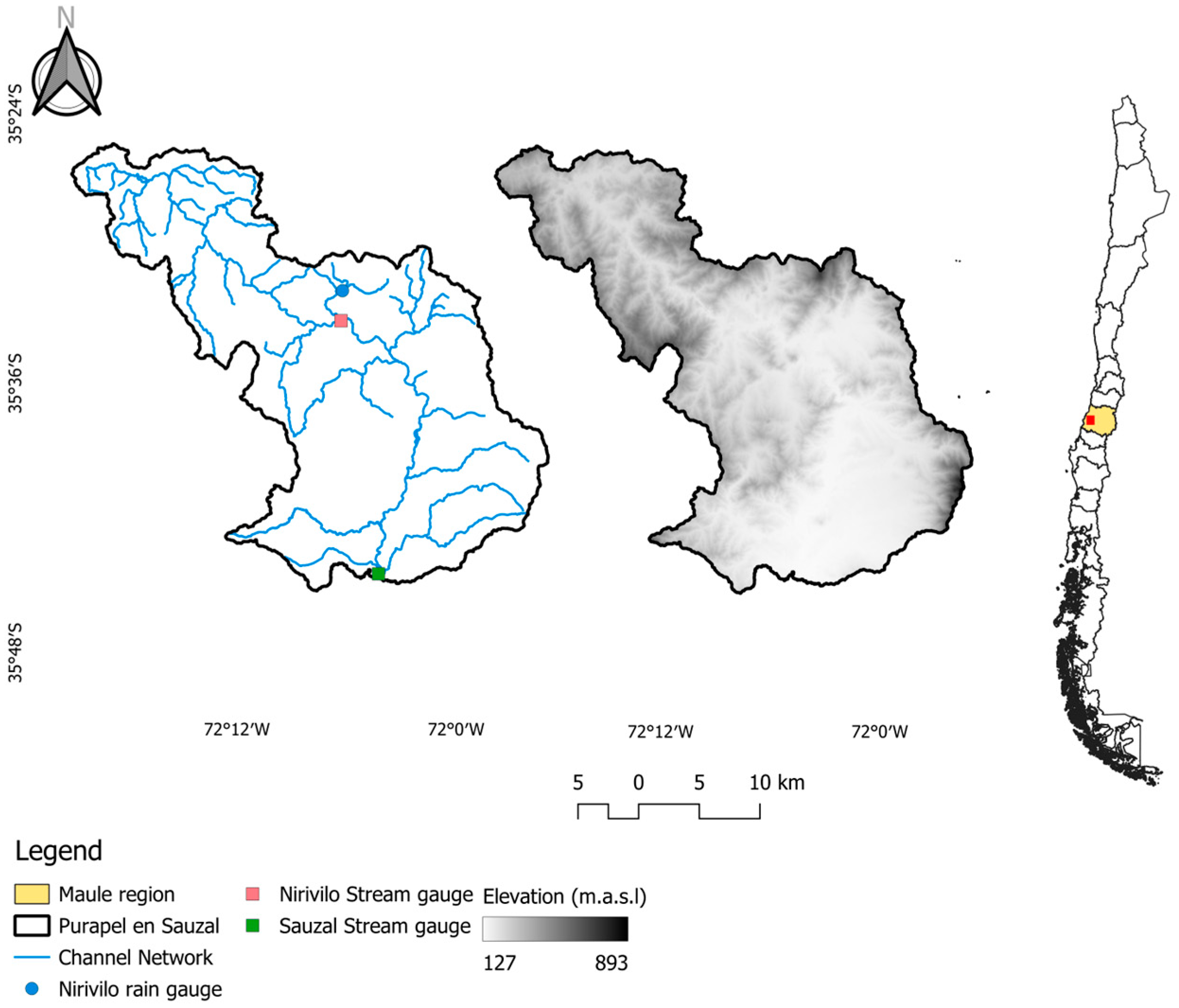
Figure 1. Location of the Purapel experimental watershed within Chile.
Sustainability 17 09930 g001
Figure 3. Map of soil texture in the Purapel experimental watershed. Source: Galleguillos et al. [42] using the CLSoilMaps layer.
Sustainability 17 09930 g003
Figure 4. Types of hypsometric curves in a watershed.
Sustainability 17 09930 g004
Figure 5. Example view of post-fire pine seedlings, a widespread effect evidenced in the Purapel in Sauzal watershed areas previously occupied by adult pine plantations, following the 2017 wildfire event.
Sustainability 17 09930 g005
Figure 6. Precipitation anomaly at Nirivilo station.
Sustainability 17 09930 g006
Figure 7. Precipitation and streamflow time series in the watershed. (A) Precipitation time series (1985–present), (B) Monthly average precipitation (1985–present), (C) Streamflow time series (1985–present), and (D) Monthly average streamflow (1985–present).
Sustainability 17 09930 g007
Figure 8. Hypsometric curves for the Purapel en Nirivilo and Purapel en Sauzal watersheds.
Sustainability 17 09930 g008
Figure 9. Temporal evolution of EVI at the Purapel in Sauzal experimental watershed.
Sustainability 17 09930 g009
Figure 10. Variability of annual sediment concentration data at Purapel in Sauzal station, for dry and wet seasons. Beginning of the 2016–2017 wildfire season is indicated by dashed red line.
Sustainability 17 09930 g010
Figure 11. Temporal variation in parameters b0 and b1 in Purapel en Sauzal. Beginning of the 2016–2017 fire season in indicated by dashed red line.
Sustainability 17 09930 g011
Figure 12. Temporal behavior of sediment load (ton/year) for (a) dry season, (b) wet season, and (c) annual in the Purapel watershed.
Sustainability 17 09930 g012
Figure 13. Temporal behavior of PCA1 quantiles in the Purapel watershed.
Sustainability 17 09930 g013
Table 2. Mann–Kendall test results for regression coefficients.
SeasonCoefficientZSen Slopep-Value
Dryb0−1.265−0.0430.206
b1−0.876−0.0060.381
Wetb0−3.153−0.4500.002
b1−2.125−0.0120.034
Disclaimer/Publisher’s Note: The statements, opinions and data contained in all publications are solely those of the individual author(s) and contributor(s) and not of MDPI and/or the editor(s). MDPI and/or the editor(s) disclaim responsibility for any injury to people or property resulting from any ideas, methods, instructions or products referred to in the content.