1. Introduction
There are many Emeishan basalts in southwestern China. The Emeishan basalts in Yunnan, Guizhou and Sichuan Provinces cover an area of 3.0 × 10
5 to 5.0 × 10
5 km
2 and an exposed area of 3.8 × 10
4 km
2 [
1]. The Emeishan basalt often forms steep slopes. However, due to the multiphase eruptive cyclogenesis process of basalt formation, numerous primary structural surfaces have developed within the rock mass. These primary structures, combined with the influence of tectonic activity, unloading, and weathering, gradually deteriorate the mechanical parameters of basalt slopes. As a result, these steep basalt slopes are prone to large-scale landslides that are triggered by factors such as human engineering activities, intense rainfall, or strong earthquakes. The Emeishan basalt is known to have caused significant landslide disasters in recent years (
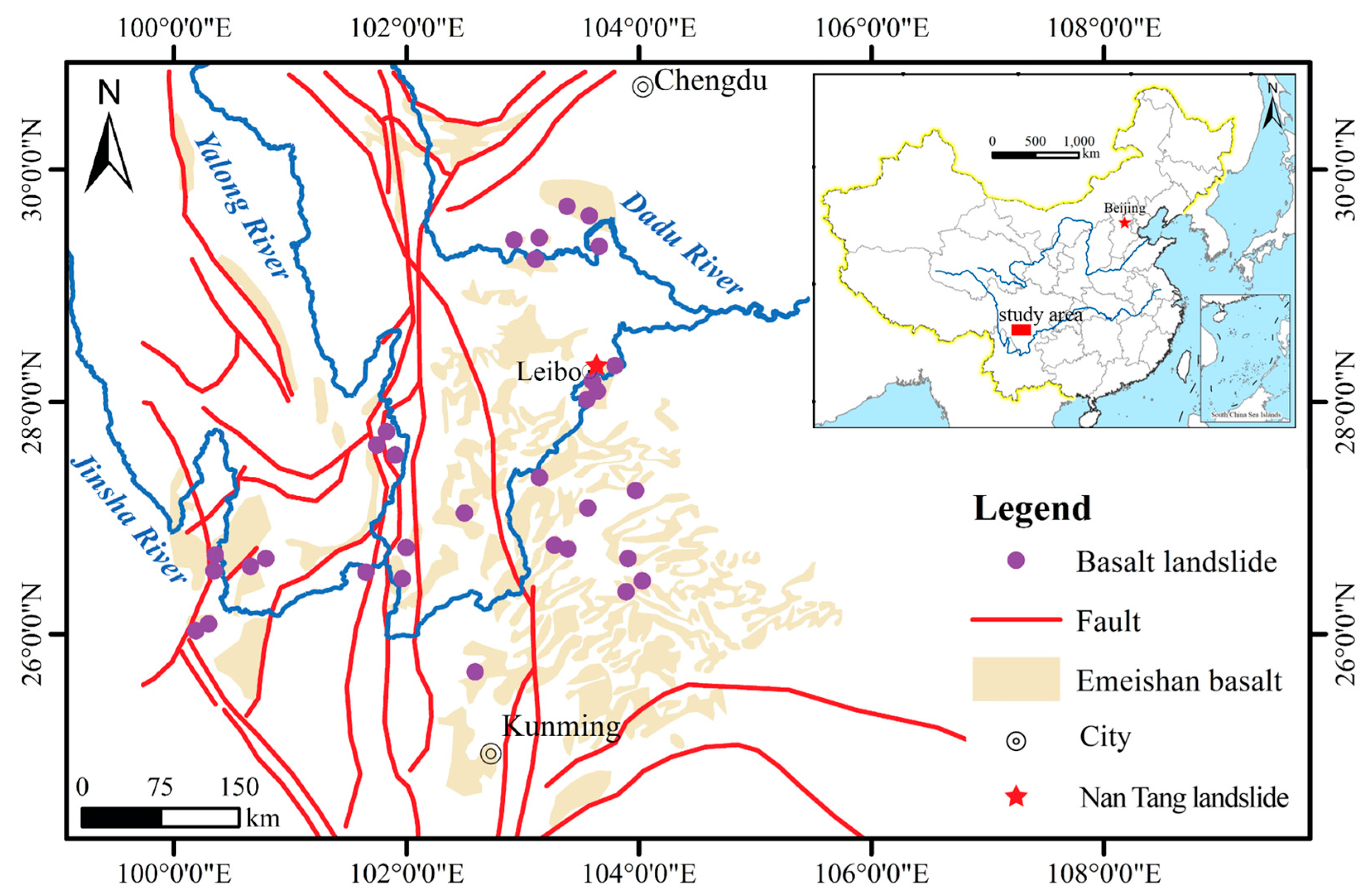
Figure 1), resulting in a high number of casualties and extensive property damage [
2,
3,
4,
5,
6,
7]. Understanding the mechanisms behind these destructive basalt landslides is crucial for implementing effective measures to reduce and prevent such disasters [
4,
8,
9].
Excavation, particularly at the heel of a slope, along with rainfall, are the two primary factors contributing to slope instability. Excavation significantly alters the stress distribution within a slope, inducing localized stress concentration phenomena, such as shear stress concentration at the slope toe and tensile stress concentration at the slope crest [
10,
11]. Furthermore, excavation exposes the rock mass to external environmental conditions, thereby accelerating the weathering process of the slope. This leads to the rapid degradation of the mechanical properties of the rock mass near the excavated surface [
12,
13,
14], further undermining the overall stability of the slope. Rainfall infiltration exacerbates the propagation and connection of cracks, increases the weight of rock and soil mass, and reduces the mechanical properties of rock and soil mass, ultimately causing slope instability [
15,
16]. In recent years, many landslides that were affected by excavation and rainfall have been reported, and many scholars have tried to analyze the formation mechanism of basalt landslides [
17,
18,
19,
20]. Notably, the material composition and structural characteristics of landslide deposits are also one of the important influencing factors [
21]. For the cataclastic basalts in the Emeishan area, their cataclastic rock mass structure and dense internal primary structural planes amplify the impact of excavation-induced weathering, and the deterioration of their shear strength is more pronounced compared to intact rock masses. To accurately capture the mechanical properties of such rock masses, in situ rock borehole shear tests are a highly effective method [
22,
23]. This method can directly measure the shear stress–displacement relationship of the rock mass under in situ stress conditions, effectively avoiding parameter deviations caused by sample disturbance due to difficulty in sampling cataclastic rocks in laboratory tests.
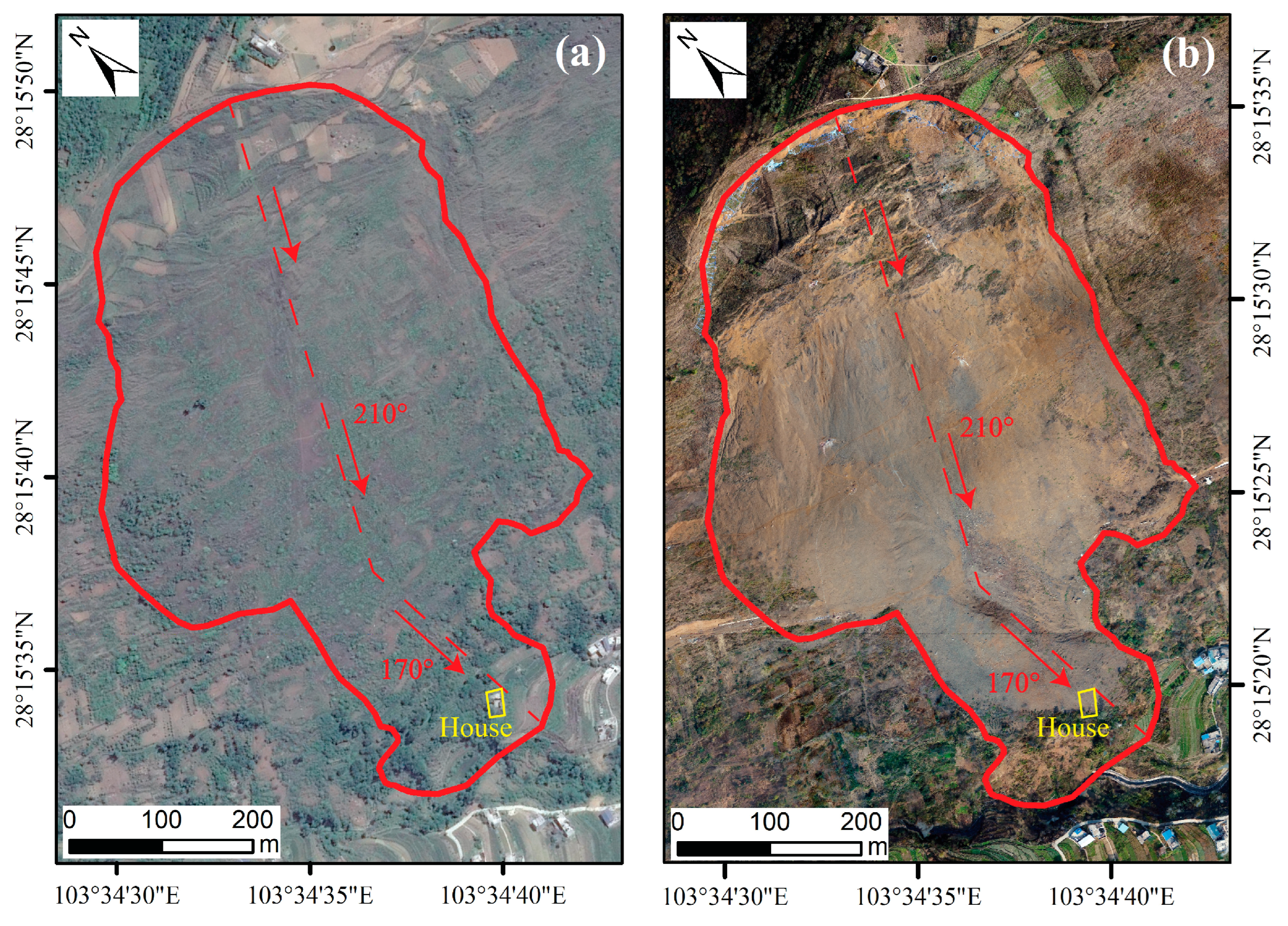
Because the shear strengths of cataclastic Emeishan basalt are weak, the initial stability of the slope is poor. The Emeishan basalt slopes are highly susceptible to catastrophic landslides under the influence of excavation or rainfall. On 2 July 2017 (UTC+8), at approximately 5:00, a landslide occurred on a basalt slope in Nantang Village, Leibo County, Sichuan Province, due to road excavation and rainfall (referred to as the Nantang landslide hereafter). The Nantang landslide (NT landslide) resulted in the burial of approximately 2.5 km of road and approximately 1.5 × 10
4 m
2 of farmland and caused damage to one house (
Figure 2). To gain a deeper understanding of the destructive mechanisms of basalt landslides in Southwest China, an in-depth study on the destructive mechanisms of the NT landslide is necessary. He et al. conducted a preliminary analysis of the mechanisms behind the occurrence of the NT landslide and concluded that rainfall was the main cause [
24]. However, our analysis of official rainfall data (obtained from the China Meteorological Data Service Centre) suggests that rainfall was not the main factor influencing the NT landslide. To elucidate the failure mechanisms of the NT landslide, we described the deformation process of the NT landslide, and then calculated its stability at different evolutionary stages based on field investigations, engineering surveys, rock borehole shear tests, and numerical simulations; from the results of this analysis, we identified that excavation is the primary influencing factor. Finally, we conducted a detailed analysis of the NT landslide’s failure mechanisms and proposed novel insights, which provide new perspectives and references for similar studies on landslide triggering mechanisms.
2. Study Area
2.1. Geological Setting
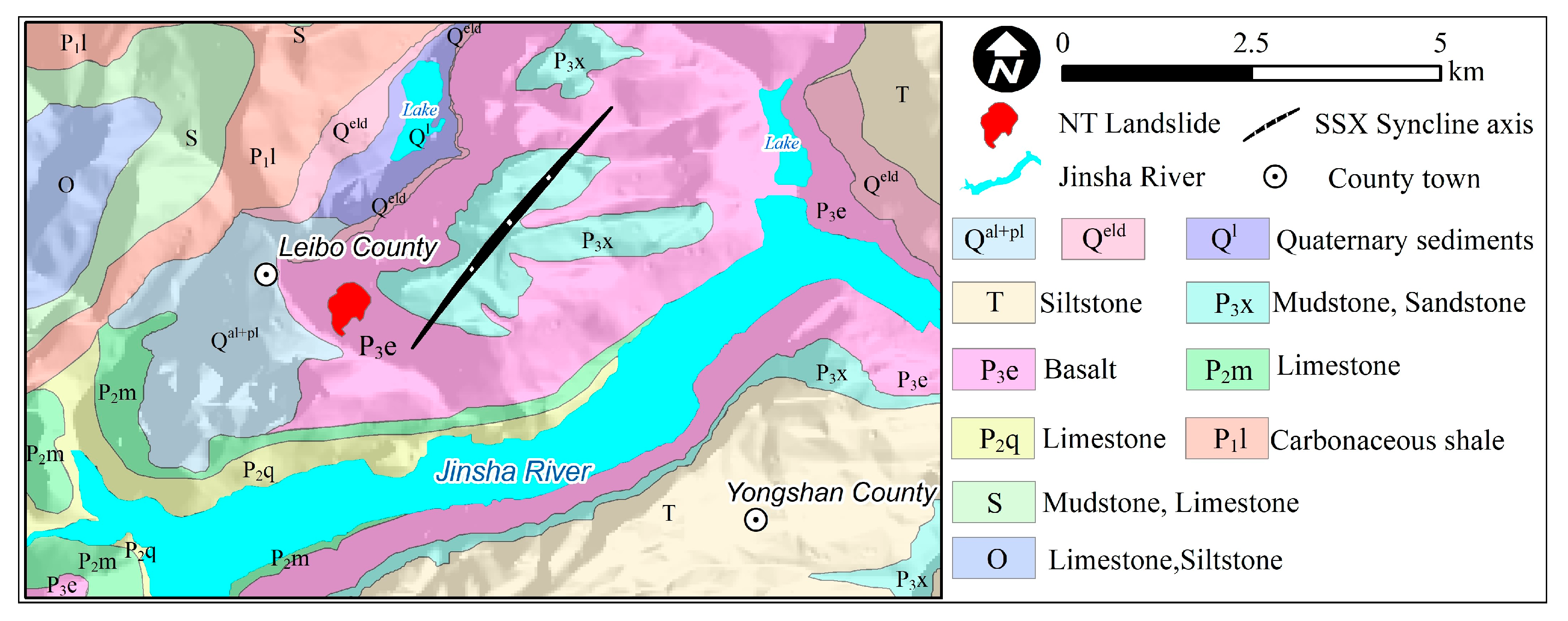
The NT landslide is situated in the central part of the Leibo-Yongshan rhombic tectonic basin, which lies on the southwestern edge of the Yangzi Plateau. It is approximately 1 km from the town of Leibo County. The main tectonic structure in the study area is the Shanshuxiang Syncline (SSX Syncline), which measures approximately 5.8 km in length and 2.5 km in width (
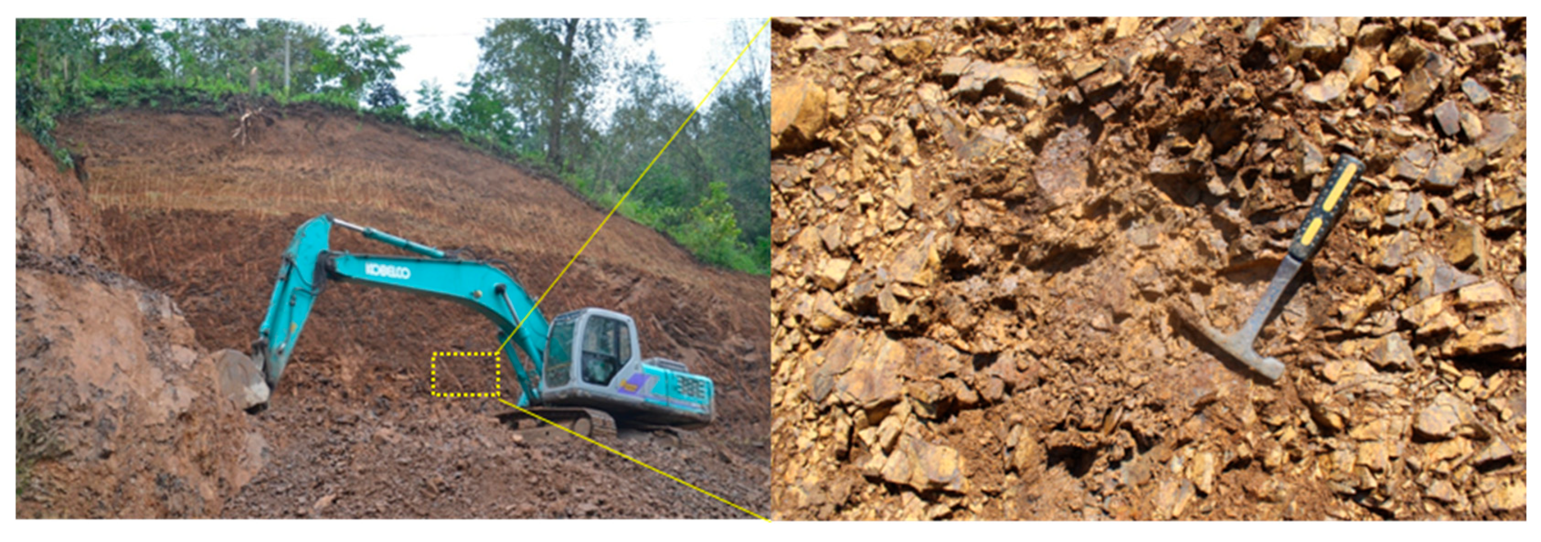
Figure 3). The NT landslide is located in the southwest limb of the SSX Syncline and has an Emeishan basalt lithology. The strata of the rock layer are N35°W/NE∠25°. The basalt rock mass has undergone strong tectonic extrusion and weathering unloading, resulting in the development of numerous joints and fissures. The weathering is severe, with the average thickness of the highly weathered rock on the sliding mass exceeding 30 m (
Figure 4).
2.2. Geomorphology
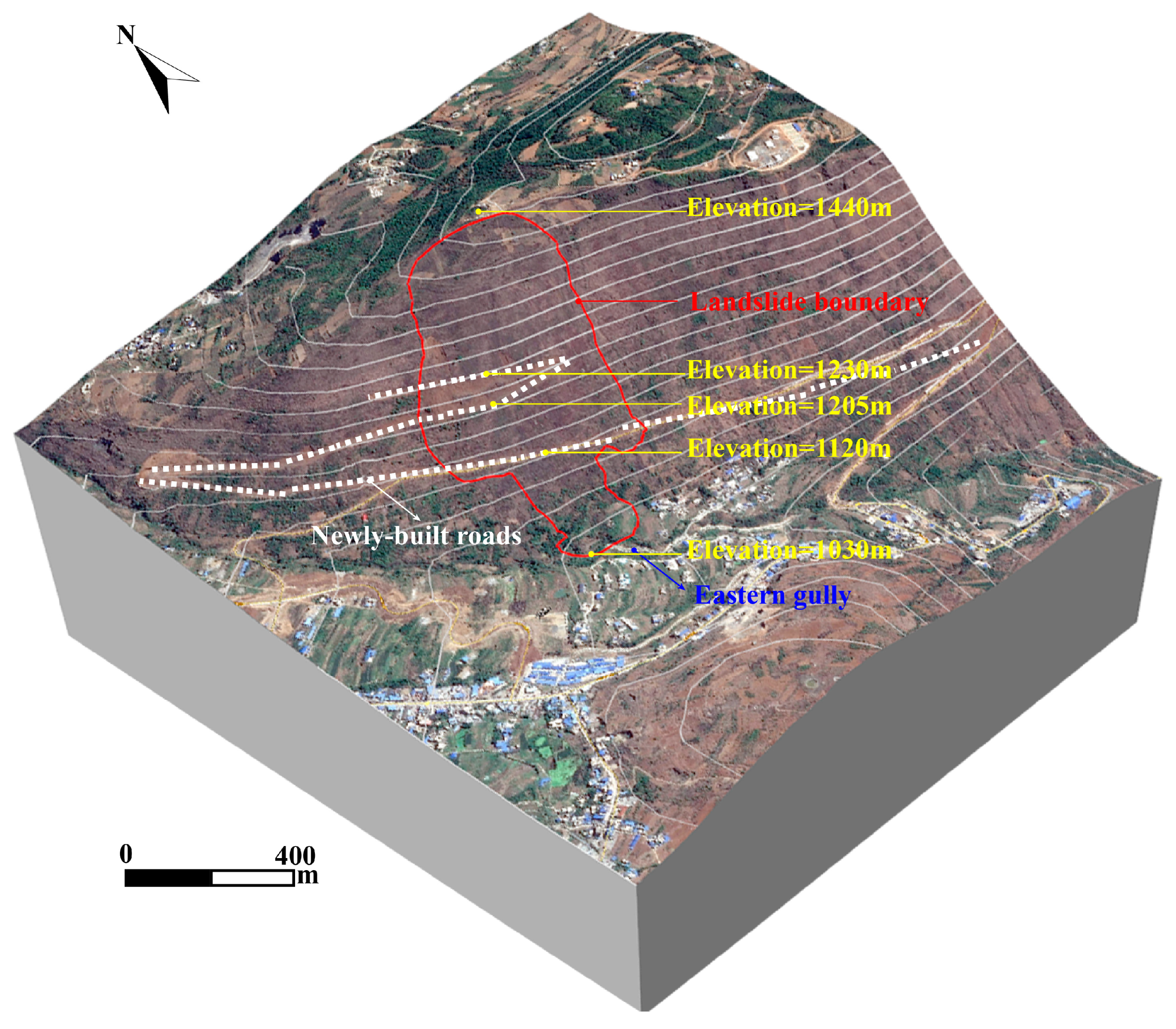
Figure 5 shows an image taken before the Nantang landslide. The slope above an elevation of 1440 m is characterized by a flat terrace, with an average gradient of 5°. The slope between elevations of 1100 m and 1440 m is steeper, with a gradient ranging approximately from 30° to 40°. Below an elevation of 1100 m, there is a gently accumulating topography with a slope ranging from 10° to 25°. There is a height difference of 410 m between the slope crest and its foot. Excavation on the slope has resulted in the formation of a beltway with an excavation width ranging from 8 m to 10 m and an excavation height ranging from 10 m to 15 m.
2.3. Climate and Hydrogeology
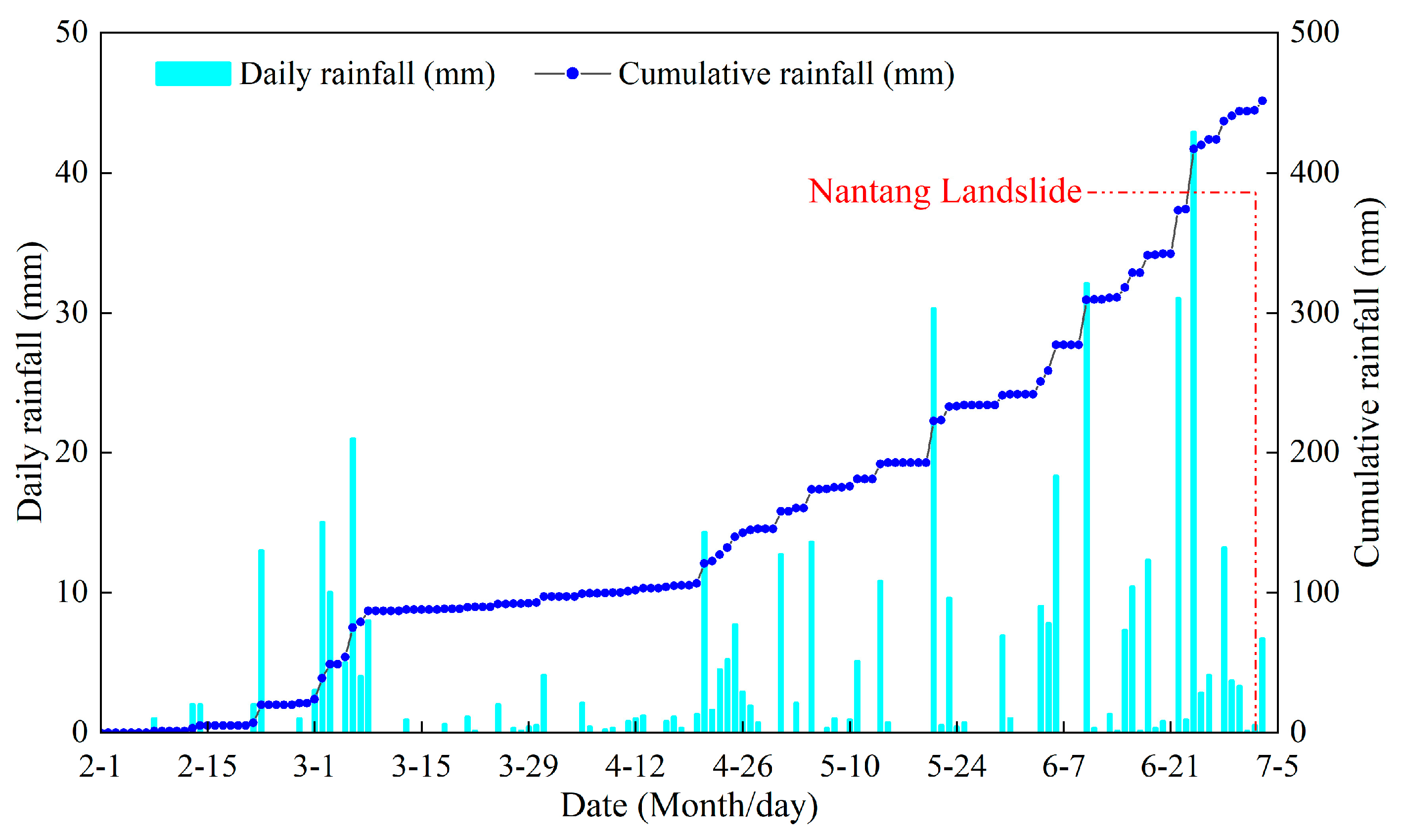
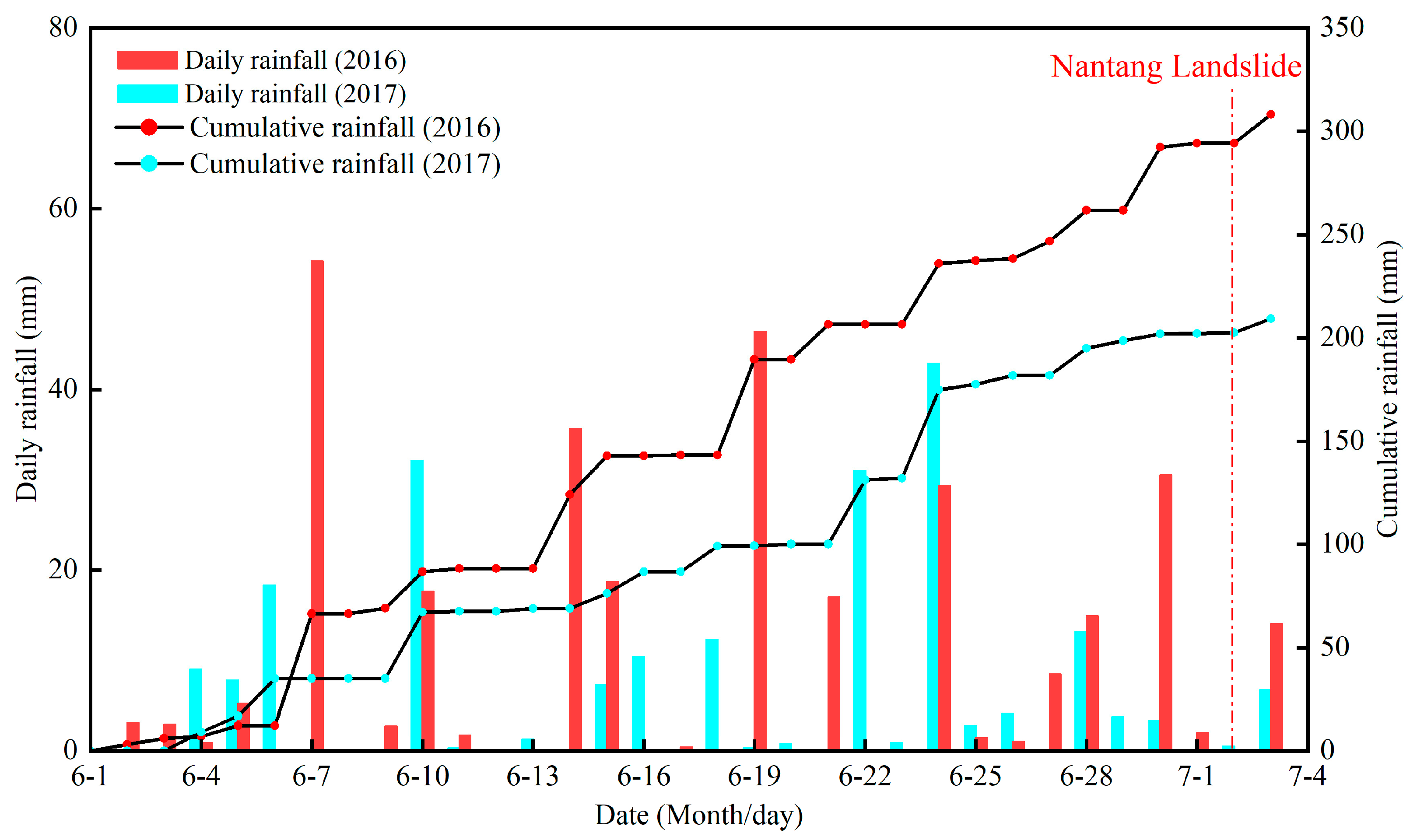
The NT landslide is located in the subtropical plateau monsoon climate zone, where the average precipitation has ranged from 586.3 mm to 851.2 mm over many years. Rainfall from April to October ranges from 90.37% to 96.55% of the annual total. According to the rainfall data from the Precipitation Observatory in the town of Jincheng, which is located approximately 1 km northwest of the landslide (
Figure 6), the cumulative rainfall of the day before and on the day of the landslide was 0.5 mm and 0.1 mm, and the cumulative rainfall of the month before the landslide was 202 mm. The groundwater around the landslide primarily consists of water in basalt bedrock fissures and is primarily recharged by atmospheric precipitation.
3. Landslide Characteristics
3.1. Deformation and Evolution History
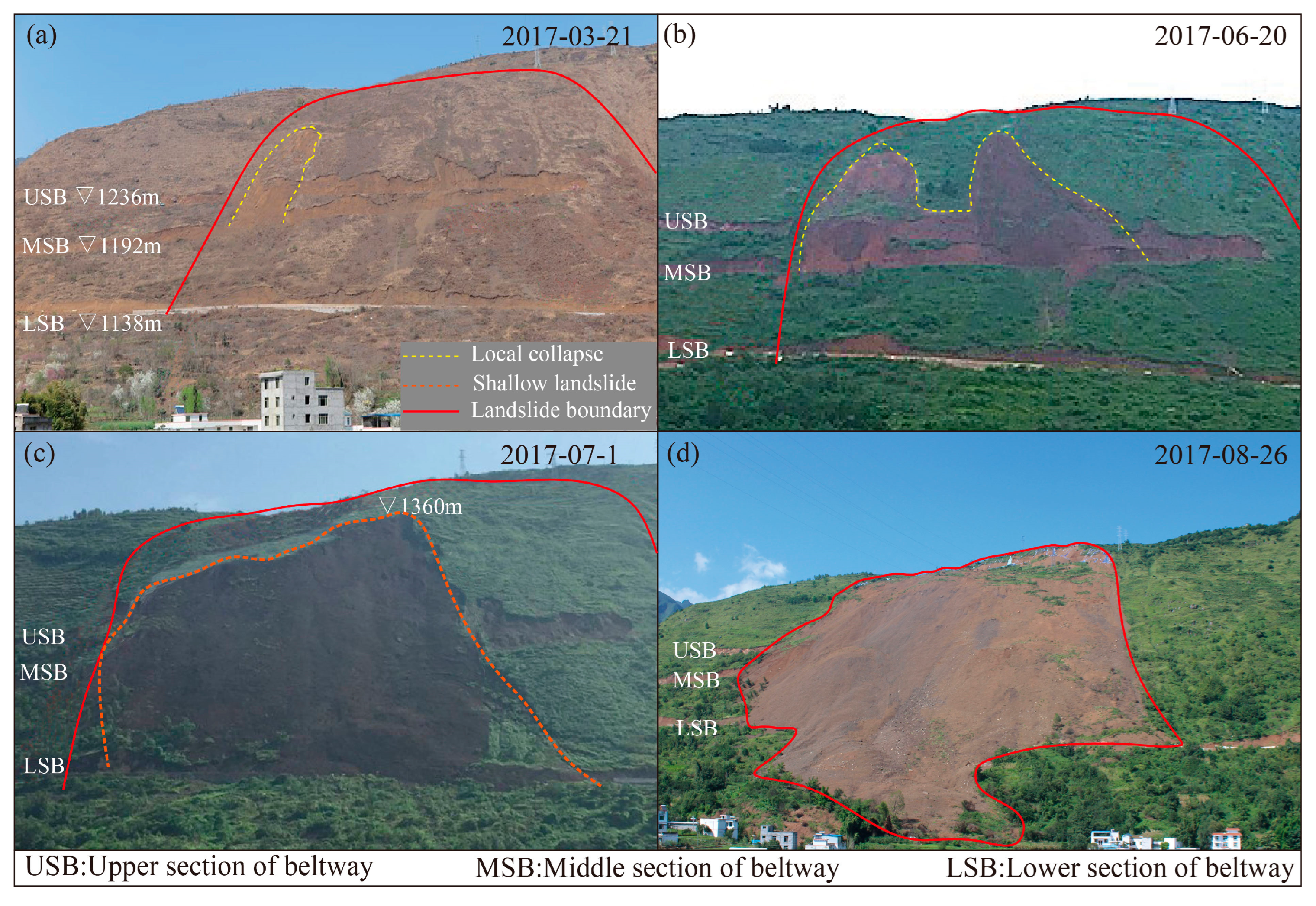
Based on interviews with nearby residents and road construction workers, it was discovered that there were two localized slumps and one shallow landslide that occurred before the NT landslide. On 21 March 2017, there was a partial collapse in the upper section of the beltway. The collapsed area had a length of 110 m and a width of 90 m (
Figure 7a). On 20 June 2017, another collapse occurred on the upper section of the beltway (
Figure 7b). Then, on 1 July 2017, a shallow landslide occurred on the slope, and a slide accumulated in the lower section of the beltway (
Figure 7c). Finally, at 5:00 a.m. on 2 July 2017, the entire landslide slipped as a whole, and the front part of the sliding mass disintegrated, forming a rock avalanche that poured down and accumulated at the foot of the slope (
Figure 7d).
As shown in the rainfall data presented in
Figure 6, there was no heavy rainfall on the day of the landslide or in the previous half-month, and the most recent rainfall prior to the landslide was also weak. Combined with other survey findings, which include that the steep slope gradient is not conducive to rainfall infiltration, no large-scale irrigation was conducted, and no groundwater was encountered during drilling, this confirms that the landslide in this case can be excluded as a rainfall-induced landslide.
3.2. Post-Landslide Characteristics
The NT landslide exhibited an inverted cone shape, with a maximum width of 410 m and a maximum length of 843 m along the sliding direction, resulting in a total area of 2.4 × 10
5 m
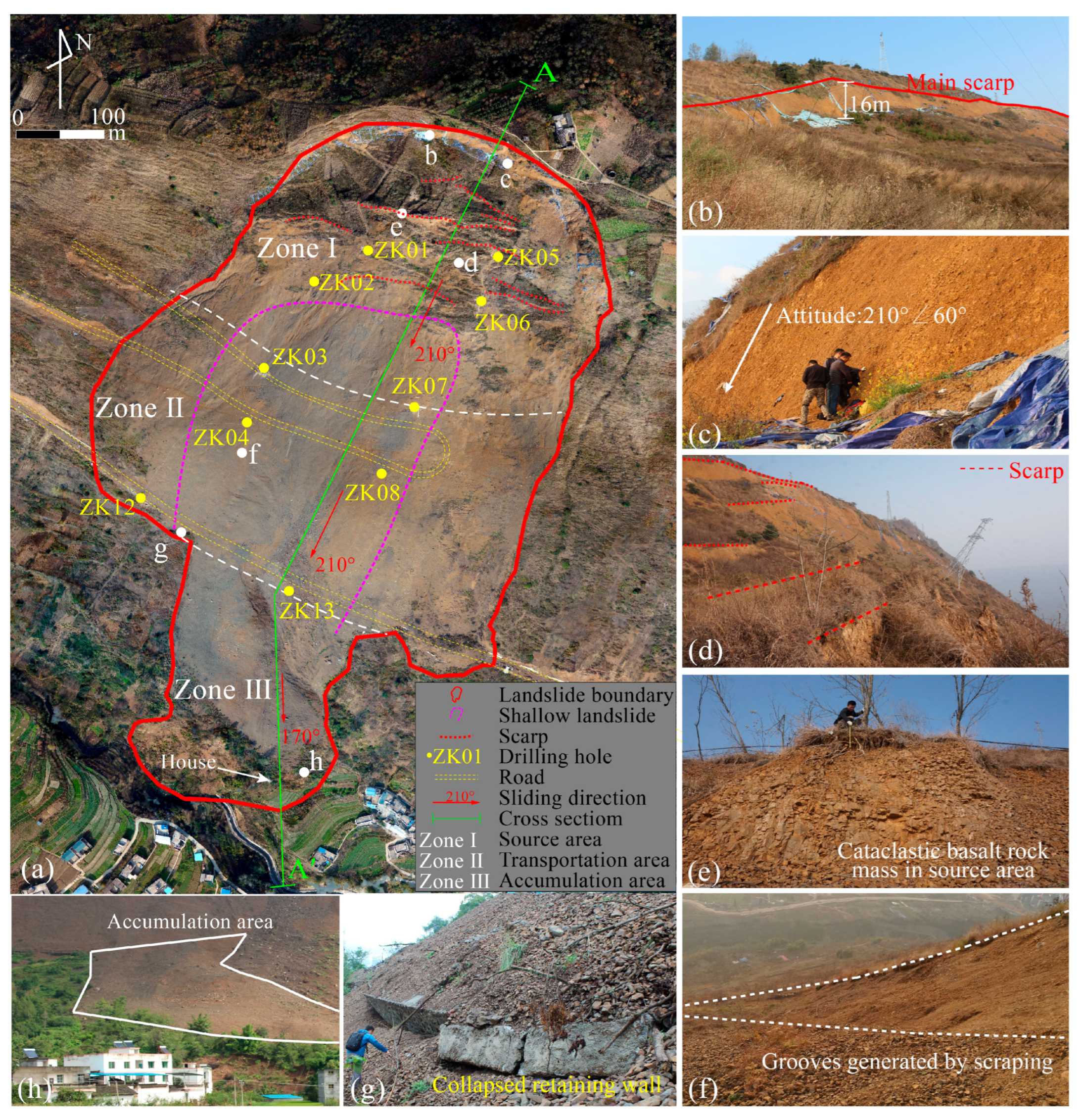
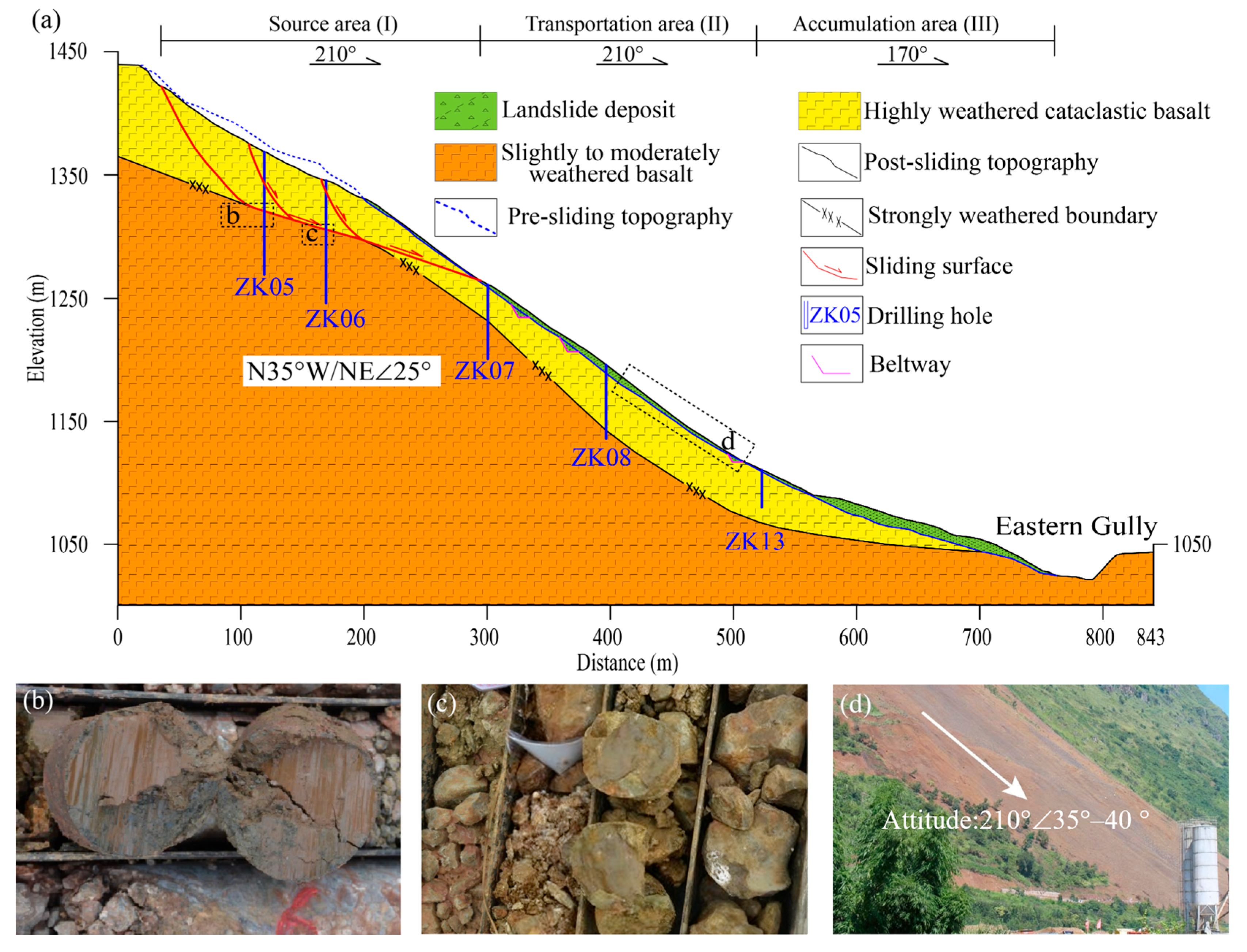
2. Initially, the landslide moved in a 210° direction, but its movement was obstructed by the retaining wall, causing it to change to a 170° direction before accumulating at the foot of the slope. Based on the characteristics of the landslide failure and accumulation, the geotechnical zones within the landslide area have been identified as follows: the source area (Zone I), the transportation area (Zone II), and the accumulation area (Zone III) (
Figure 8a).
The source area (Zone I) is situated between elevations of 1265 m and 1440 m, with an incline ranging from 15° to 30°. The maximum length of the source area is 300 m, the width is 360 m, and the plane area is approximately 1.0 × 10
5 m
2. The direction of movement of the landslide is S20°W, and the rear edge of the landslide forms a banded main scarp (
Figure 8b) with a height of approximately 10 m to 17 m and a slope inclination of 50° to 60° (
Figure 8c). Multiple-stage scarps can be observed in the middle of the source area (
Figure 8d). On-site investigations confirmed that the scarps within the source area were dry on the day of the landslide. The sliding mass primarily consists of highly weathered cataclastic basalt (
Figure 8e). Scratches observed through drilling at ZK05 and ZK06 (
Figure 9b,c) provide insight into the depth of the sliding surface. Combining this with the position of the shear outlet, the location of the sliding surface can be inferred, and the approximate thickness of the sliding mass is estimated to be between 40 m and 76 m, with a total volume of approximately 4.6 × 10
6 m
3. Most of the sliding mass (with a volume of approximately 4.1 × 10
6 m
3) remains within the source area, largely preserving the original stratigraphic characteristics. The transmission tower situated on the sliding mass is inclined forward but has not completely collapsed. The leading section of the sliding mass broke through the shear outlet, disintegrated, and accumulated as a rock avalanche in the eastern gully at the base of the slope.
The transportation area (Zone II) is situated at an elevation ranging from 1117 m to 1265 m, with a slope inclination of approximately 35° to 40° (
Figure 9d). The transportation area exhibits a trapezoidal shape on the plane, measuring a maximum width of 432 m and a surface area of approximately 8.8 × 10
4 m
2. The landslide moved in a 210° direction, resulting in the scraping and pushing of loose material on the surface of the transportation area toward the lower part of the slope. The movement of the landslide has also generated grooves on the surface of the transportation area (
Figure 8f). Based on drilling results, the thickness of the accumulated material in the transportation area is estimated to range from 5 m to 15 m, with an approximate volume of accumulation reaching 5.7 × 10
5 m
3.
The accumulation area (Zone III) is situated at the base of the slope, with elevations ranging from 1030 m to 1117 m. When the rock avalanche encountered the retaining wall (
Figure 8g), its movement direction shifted from 210° to 170°, ultimately accumulating on the left bank of the eastern gully, resulting in the formation of an accumulation area with a slope incline of approximately 15° to 20°. The landslide event resulted in the destruction of a house and the toppling of a significant number of trees (
Figure 8h). By analyzing the digital elevation model prior to and after the landslide, the projection area of the accumulation area was calculated to be approximately 4.8 × 10
4 m
2. The average accumulation thickness was estimated to be approximately 20 m, with an accumulation volume reaching approximately 9.6 × 10
5 m
3.
4. Predisposing Factors and Trigger
4.1. The Effect of Highly Weathered Basalt
The NT landslide mainly consists of highly weathered Emeishan basalt. The basalt rock mass contains numerous primary structural planes due to the characteristics of multiple eruption cycles and condensation shrinkage during basalt diagenesis. Moreover, the NT landslide is situated in the southwest limb of the SXX syncline. Over time, the rock mass of the slope has experienced significant tectonic compression, resulting in the development of numerous structural planes. Additionally, the mechanical properties of the rock mass have further deteriorated due to intense weathering and unloading.
The direct shear test and triaxial compression test are often used to measure the shear strength parameters of small-sized rock specimens. In contrast, the Rock Borehole Shear Test (RBST) is an effective in situ device for determining the shear strength of rock masses [
25,
26,
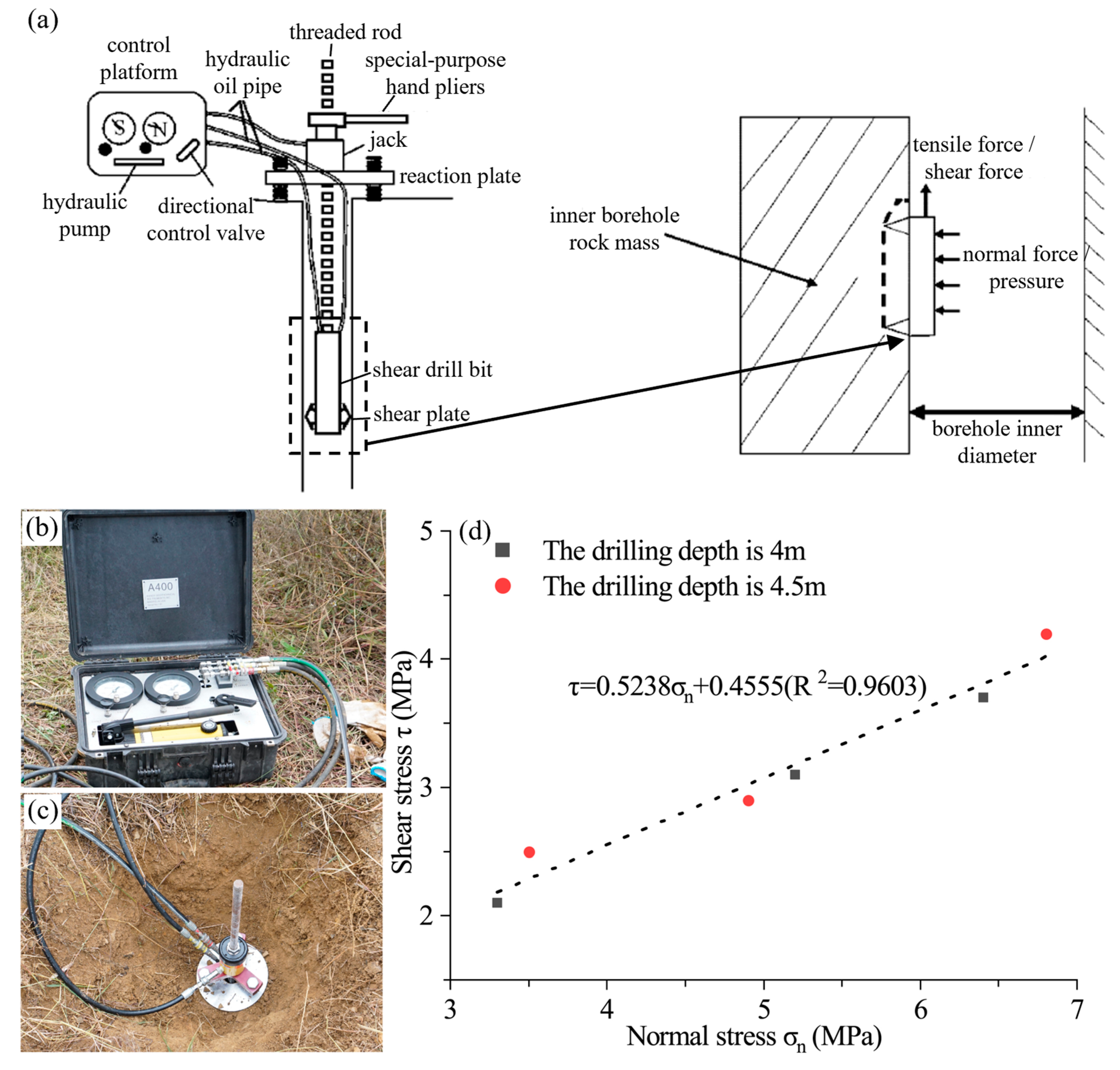
27]. The RBST can effectively account for the mechanical properties of rock masses under natural conditions while avoiding disturbances caused by sampling. The test principle of the RBST mainly involves the following steps: the surface hydraulic system applies normal pressure to the shear head, forcing the multi-layer shear plates with tooth-shaped protrusions on the shear head to press into the rock wall. A thin rock slice is then formed between every two layers of the protruding shear plates. Subsequently, the hydraulic system provides a pulling force (shear force) to the vertical connecting rod, thereby realizing the shearing of the thin rock slice (both the normal stress and shear stress applied each time can be directly read from the hydraulic control system). By adjusting the hydraulic pressure (normal stress) exerted on the shear head, the shear stress at the time of rock failure can be obtained, and the Mohr-Coulomb envelope can thus be plotted (
Figure 10a).
To determine the shear strength parameters of the highly weathered basalt rock mass, two sets of in situ borehole shear tests using RBST were conducted in the non-sliding portion at the rear edge of the landslide (
Figure 10d). The experimental results revealed a cohesion value of 0.46 MPa and a friction angle of 27.6° for the highly weathered basalt. The slightly to moderately weathered basalts displayed relatively good integrity (
Figure 11). Drilling data and laboratory test results indicate that the cohesion and friction angle for the slightly to moderately weathered basalt are 5.2 MPa and 46°, respectively, which are significantly higher than those of the highly weathered basalt. The highly weathered basalt rock mass easily experiences slipping along the highly weathered interface when subjected to external disturbances.
4.2. Excavation Activities
The excavation of the beltway created a steep free surface ranging from 10 m to 15 m, altering the slope’s original geometry. The rock mass near the excavation surface, upon losing support, experienced concentrated shear stress and rebound after unloading, resulting in local collapse. The excavation, along with the subsequent local collapse, altered the stress distribution on the slope and created favorable terrain conditions for slope instability. Therefore, excavation was the primary cause of the occurrence of the NT landslide.
4.3. Persistent Continuous Rainfall Preceding the Landslide
The rainfall data indicate that on the day of and the day prior to the landslide, there was 0.5 mm and 0.1 mm of rainfall, respectively (
Figure 12). Additionally, the cumulative rainfall in the week preceding the landslide amounted to 27.2 mm. In the month preceding the landslide, the cumulative rainfall was 202 mm, which was lower than the monthly cumulative rainfall (292.3 mm) during the same period in 2016. Investigation revealed that both the main scarp and the scarps within the landslide area were dry, effectively ruling out the possibility of the NT landslide being directly triggered by rainfall. However, importantly, the heavily weathered rock mass contained a significant amount of weathered clay, leading to increased water absorption and water-holding capacity. The infiltration of rainfall may have resulted in an increase in bulk density and a decrease in shear strength of the highly weathered basalt rock mass [
28,
29], potentially promoting local collapse and shallow landslides along the slope after excavation, ultimately contributing to the occurrence of the NT landslide.
5. Numerical Simulation
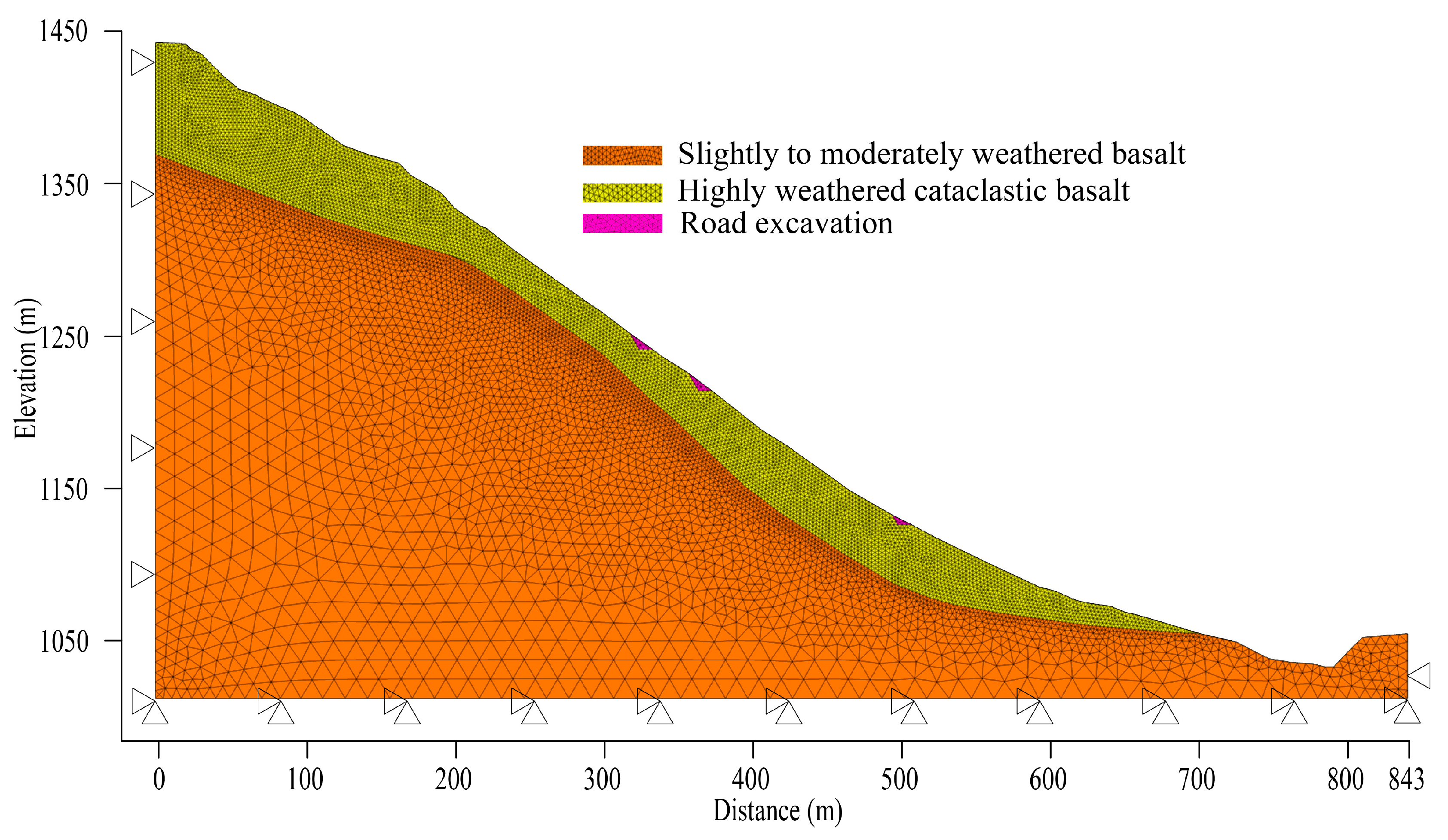
To better understand the mechanisms of the NT landslide, considering that the NT landslide has a uniform overall geological structure, 2D simulation can meet the analysis needs, and 3D analysis offers limited added value for stability analysis while significantly increasing modeling complexity, a two-dimensional numerical model of the landslide (
Figure 13) is established using the finite difference software FLAC3D 5.0 based on the engineering profile (
Figure 9). The bottom, left, and right sides of the model are fixed boundaries, while the surface is a free boundary. In mesh generation, triangular meshes are used for division: meshes near the sliding surface and within the sliding mass are meshed more finely with a size of 2 m, and they gradually transition to 10 m toward the interior of the slope, with a total of 25,472 meshes generated. The three scenarios, namely, before beltway excavation, after beltway excavation, and after the occurrence of the shallow landslide, are calculated. The deformations and shear strain increments at different stages of the slope are analyzed, and the overall factor of safety of the slope in each stage is calculated using the strength reduction method. The numerical calculation adopts the Mohr-Coulomb yield criterion. This criterion is suitable for reflecting the shear failure characteristics of geotechnical materials and its key parameters are easy to obtain, but it also has limitations of ignoring material anisotropy and not considering the influence of intermediate principal stress. It is quite practical in simple two-dimensional simulation scenarios. The shear strength parameters of the highly weathered basalt were determined through in situ borehole shear tests. The elastic modulus of the highly weathered basalt and other parameters of the slightly to moderately weathered basalt was estimated using the Hoek–Brown empirical strength criterion [
30].
Table 1 presents the parameters of the materials used in the numerical calculations.
6. Results
6.1. Numerical Simulation Results
The shear strain increment can indicate the shape and position of the potential sliding surface [
7,
31,
32]. In addition, displacement can be used to indicate the location of deformation. According to
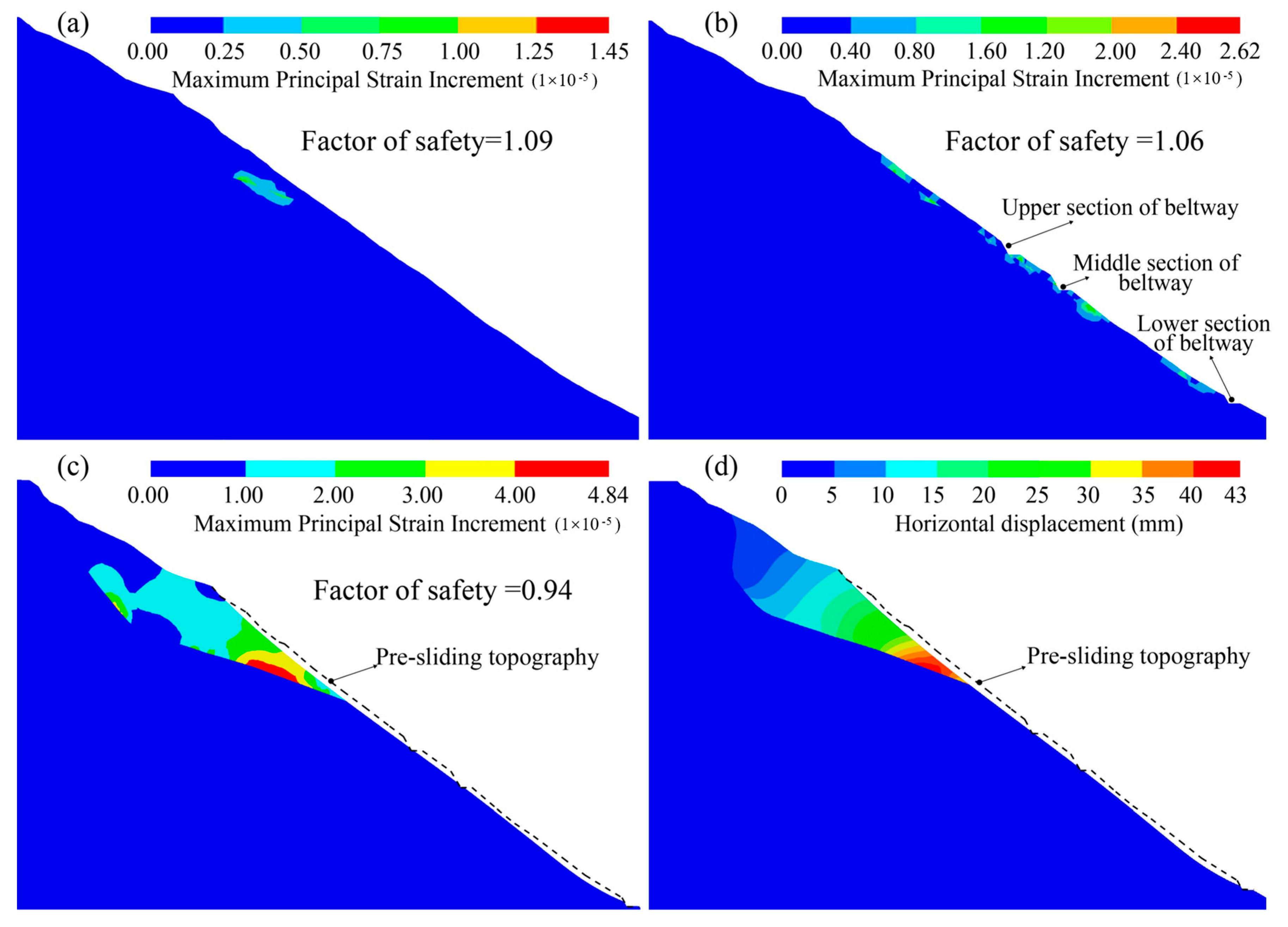
Figure 14a, there is a small increment of shear strain in the slope’s original state, with a maximum increment of 1.45. The factor of safety of the slope is 1.09, indicating that the landslide is in a stable state. As shown in
Figure 14b, shear stress concentration occurs near the excavation surface and on the surface of the slope after excavation. The maximum shear strain increment of the slope is 2.62, and the factor of safety is 1.06.
Figure 14c shows that after the occurrence of the shallow landslide, the area of shear strain increment inside the slope further expands and extends to the back of the landslide, with a maximum shear strain increment of 4.84. The deformation of the sliding mass gradually transfers from the front to the back (
Figure 14d). The maximum displacement in the front part of the sliding mass is 43 mm, in the middle part is 14 mm, and in the rear part is 4.5 mm. The factor of safety of the slope is 0.94.
6.2. Failure Mechanisms
The highly weathered Emeishan basalt has relatively weak shear strength, a prerequisite that results in poor stability of the slope itself, making it prone to landslides under the disturbance of external factors. The sliding surface of the Nantang Landslide presents a chair-like shape, with the middle and front sections of the sliding surface being gentle and the rear section having a steeper slope. The middle and front sections, with their relatively gentle sliding surface, constitute the anti-sliding segment of the landslide and provide the main anti-sliding force. The rear sliding surface, with a larger slope, allows the sliding mass to move downward under the action of gravity, thus forming the sliding-promoting segment of the Nantang Landslide. Affected by road excavation and rainfall, multiple local collapses and surface sliding occurred in the middle part of the slope, leading to the loss of materials in the anti-sliding segment. This not only created favorable topographic conditions but also reduced the anti-sliding force, ultimately resulting in the occurrence of the Nantang Landslide. Based on investigation and numerical simulation, we propose three stages for the formation mechanism of the landslide.
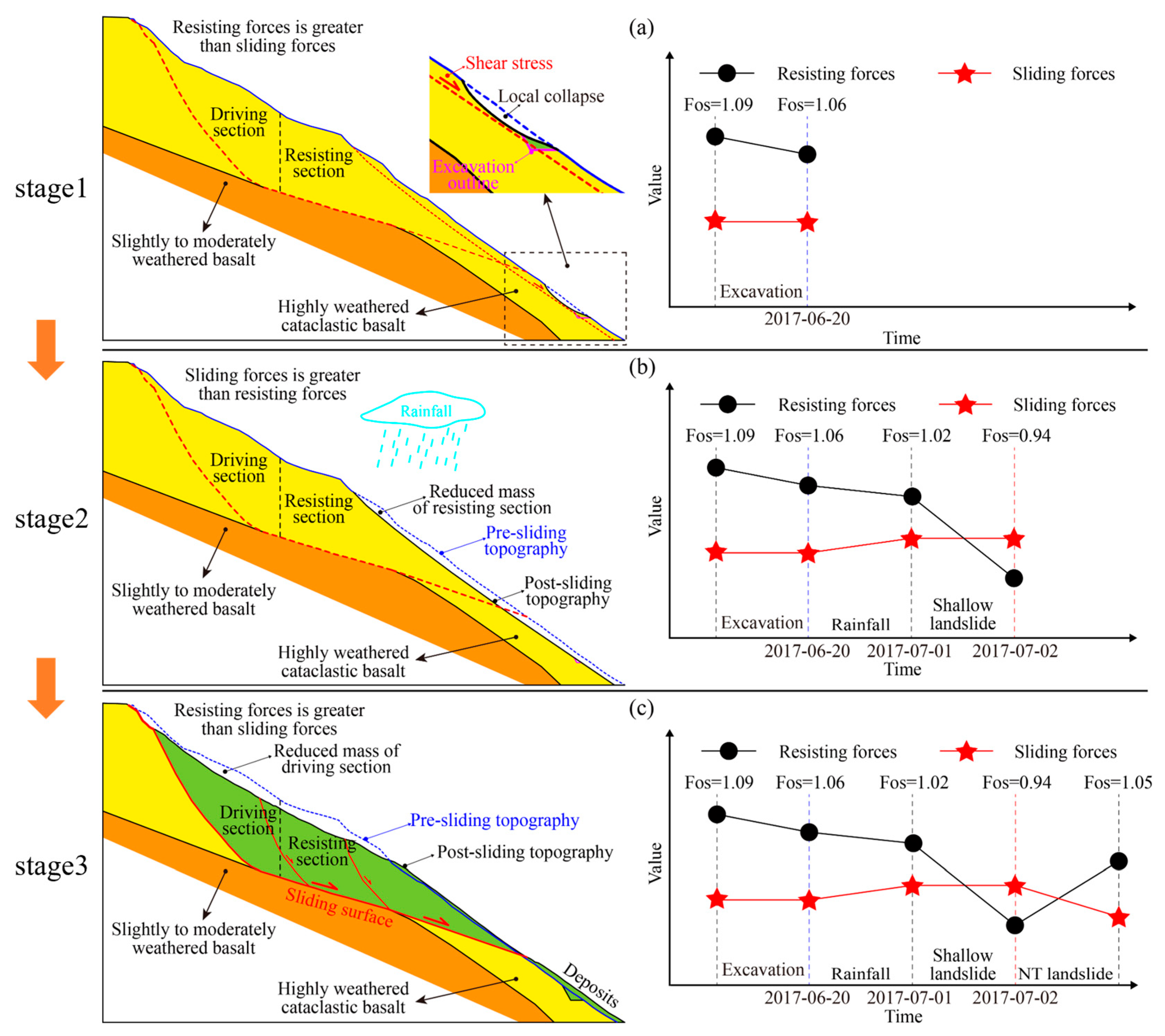
Stage 1: The excavation of the beltway formed a free face with a height of 10 to 15 m on the slope. Due to the close construction distance between the upper section and middle section roads, the excavation caused significant disturbance to the slope. Furthermore, the slope near the upper section road had the steepest gradient, so a localized collapse first occurred at the excavation face of the upper section road. The excavation and local collapse enlarged the free face of the slope’s front edge and reduced the sliding mass of the front edge’s resisting section. The factor of safety of the slope decreased due to the increased range of the front edge’s free face and the reduction in resistance forces (
Figure 15a).
Stage 2: Influenced by rainfall infiltration, there was an increase in the water content in the shallow rock and soil mass of the slope, leading to an increase in the weight of the sliding mass and a decrease in shear strength. This local collapse expansion triggered a shallow landslide on the slope. After shallow sliding, the front rock mass no longer supported the rock mass in the back, causing a significant reduction in the resisting force and lowering the overall factor of safety of the landslide to less than 1 (
Figure 15b).
Stage 3: After the abrupt decrease in sliding resisting forces, the shear stress gradually transferred from the front to the back of the sliding mass, and the sliding surface gradually became thorough. The sliding mass did not undergo movement as a whole but showed characteristics of retrogressive failure. Multistage scarps formed in the middle and rear of the sliding mass (
Figure 8d). After the sliding mass underwent progressive failure stage by stage, its overall morphology adjusted. Since the upper part of the sliding mass had already slid, the overall sliding force of the landslide decreased; meanwhile, the sliding mass that had slid to the lower part increased the mass of the anti-sliding section, which enhanced the anti-sliding force. As a result, the overall factor of safety of the slope increased, bringing the landslide into a relatively stable state (
Figure 15c).
During the entire evolution process, first, excavation leads to the formation of a free face on the slope, resulting in shear stress concentration in the high and steep section of the highway at the upper part of the slope. Shear strain first accumulates in the excavation-disturbed area. When the strain value exceeds the critical shear strain, local collapse occurs on the excavation face of the upper highway, which further expands the scope of the free face. This is equivalent to directly removing part of the soil in the anti-sliding section, leading to a decrease in anti-sliding force. At the same time, the shear stress concentration area extends along the collapsed slope surface, shear strain accumulates slowly in the shallow part of the slope, and the slope stability begins to decrease. Subsequently, the water-rock interaction caused by rainfall infiltration directly leads to the rapid attenuation of the shear strength of the rock and soil mass. In contrast, the sliding force in the upper part increases due to the higher water content of the sliding mass [
33]. The anti-sliding force in the middle-front part of the slope fails to counteract the increased sliding force, forming a locked section with concentrated shear stress at the junction of steep and gentle sections at the front of the sliding surface. Shear strain accumulates rapidly and crack propagation intensifies. When the shear stress along the shallow sliding surface exceeds the shear strength of the sliding surface, shallow sliding is triggered. Shallow sliding directly impairs the supporting effect of the anti-sliding section in the middle-front part. This causes shear stress to gradually transfer from the front section to the rear section, leading to progressive retrogressive failure of the deep sliding mass.
7. Conclusions
The characteristics of the NT landslide and the factors governing its occurrence were systematically analyzed via on-site geological surveys, drilling, in situ shear tests, and numerical simulations, and novel insights into the failure mechanism of the NT landslide were proposed. The key findings are summarized as follows:
Prior to the overall sliding event, the NT landslide experienced two episodes of local collapse and one shallow landslide, which were closely associated with excavation activities and rainfall; post-landslide evaluations of topography, geomorphology, and material composition further enabled its classification into three distinct functional zones, namely the source area, transportation area, and accumulation area. Furthermore, the NT landslide occurred within a highly weathered basalt stratum, wherein the slope rock mass exhibits a cataclastic texture, weak mechanical properties, and inherently low stability—these geological conditions collectively constitute the essential prerequisite for the initiation of the NT landslide.
- 2.
Trigger mechanisms of the NT landslide
The joint action of excavation activities and rainfall led to the occurrence of the NT landslide, but excavation was the main factor causing the landslide. The sliding surface of the NT landslide was chair-shaped, the middle and front sliding surfaces were gentle, the rear sliding surface slope was high, the front part of the landslide was a resisting section, and the rear part was a section that promoted sliding. Highway excavation led to local collapse, and rainfall aggravated local collapse and triggered a shallow landslide. With the occurrence of local collapse and the shallow landslide, the sliding mass of the anti-slide section gradually decreased, resulting in a continuous decrease in the resisting force, and the factor of safety of the slope gradually decreased to less than 1, which finally led to the occurrence of the NT landslide.
- 3.
Engineering implications for basalt slope stability
The cataclastic Emeishan basalt has unique geological characteristics: a cataclastic rock mass, low mechanical strength, high susceptibility to water, and the possibility of large-scale instability and damage even under minor artificial disturbances. Thus, prior to conducting human engineering activities such as excavation and slope cutting in basalt regions, a thorough investigation of the slope’s geo-engineering conditions is essential. This process requires analyzing the weathering degree of basalt, with special focus on highly weathered areas, as well as the development of structural planes. It also involves evaluating the impact of proposed engineering activities on slope stability. Specifically, large-scale excavation should be avoided in highly weathered basalt areas, and enhanced slope deformation monitoring systems and early warning mechanisms should be implemented in key risk zones to promptly detect abnormal movements. Such targeted plans will effectively minimize landslide disasters in these areas.
Author Contributions
D.L.: methodology, software, writing—original draft. W.F.: conceptualization, writing—review and editing. L.W. and X.Y.: investigation, software. Y.Z.: software, writing—review and editing. X.Z. and B.L.: investigation, supervision. Y.L.: investigation. All authors reviewed the manuscript. All authors have read and agreed to the published version of the manuscript.
Funding
This research was funded by the National Natural Science Foundation of China (No. 42407232) and the Opening fund of Key Laboratory of Landslide Risk Early-warning and Control, Ministry of Emergency Management, Chengdu University of Technology (No. KLLREC2022K002).
Institutional Review Board Statement
Not applicable.
Informed Consent Statement
Not applicable.
Data Availability Statement
The raw data supporting the conclusions of this article will be made available by the authors on request.
Conflicts of Interest
Author Xiushu Zeng was employed by the company Nuclear Industry Southwest geotechnical investigation and Design institute Co., Ltd., which had no role in the study. All authors declare that the research was conducted in the absence of any commercial or financial relationships that could be construed as a potential conflict of interest.
References
- Xu, Z.; Huang, R. The geological structure constraint for massive and catastrophic landslides in Permian Emeishan basalt. Geol. Rev. 2010, 56, 224–236. (In Chinese) [Google Scholar]
- Gao, Y.; Li, B.; Gao, H.; Chen, L.; Wang, Y. Dynamic Characteristics of High-Elevation and Long-Runout Landslides in the Emeishan Basalt Area: A Case Study of the Shuicheng “7.23” Landslide in Guizhou, China. Landslides 2020, 17, 1663–1677. [Google Scholar] [CrossRef]
- Ma, S.; Xu, C.; Xu, X.; He, X.; Qian, H.; Jiao, Q.; Gao, W.; Yang, H.; Cui, Y.; Zhang, P.; et al. Characteristics and Causes of the Landslide on July 23, 2019 in Shuicheng, Guizhou Province, China. Landslides 2020, 17, 1441–1452. [Google Scholar] [CrossRef]
- Zhao, W.; Wang, R.; Liu, X.; Ju, N.; Xie, M. Field Survey of a Catastrophic High-Speed Long-Runout Landslide in Jichang Town, Shuicheng County, Guizhou, China, on July 23, 2019. Landslides 2020, 17, 1415–1427. [Google Scholar] [CrossRef]
- He, K.; Ma, G.; Hu, X.; Liu, B. Failure Mechanism and Stability Analysis of a Reactivated Landslide Occurrence in Yanyuan City, China. Landslides 2021, 18, 1097–1114. [Google Scholar] [CrossRef]
- He, K.; Ma, G.; Hu, X. Formation Mechanisms and Evolution Model of the Tectonic-Related Ancient Giant Basalt Landslide in Yanyuan County, China. Nat. Hazards 2021, 106, 2575–2597. [Google Scholar] [CrossRef]
- Shen, T.; Wang, Y.; Zhao, X.; Liu, H.; Wu, X.; Chu, Y.; Zhai, P.; Han, Y. Features and Formation Mechanism of the Jiaopenba Landslide, Southwestern Sichuan Province, China. Front. Earth Sci. 2022, 10, 919268. [Google Scholar] [CrossRef]
- Yang, J.; Xu, Z.; Zhang, R.; Chen, J.; Ren, Z.; Luo, R.; Zhang, X. Formation and Evolution of Emeishan Basalt Saprolite in Vadose Zones of Touzhai Landslide Source Rockmass. J. Mt. Sci. 2017, 14, 1174–1184. [Google Scholar] [CrossRef]
- Baile, A.; Jha, M.; Jain, N.; Tignath, S.; Kinattinkara, R. Integrated Landslide Analysis Using Petrological Investigation and Drone Based High Resolution Geospatial Assessment: Irshalwadi Landslide—A Case Study from Western Ghats of India. Nat. Hazards 2025, 121, 405–421. [Google Scholar] [CrossRef]
- Quinta-Ferreira, M.; Andrade, P.S.; Lemos, L.; Saraiva, A. Cut Slopes Failures on the Triassic Beds in Coimbra, Portugal. Bull. Eng. Geol. Environ. 2013, 72, 383–396. [Google Scholar] [CrossRef]
- Pando, L.; Díaz-Díaz, L.M.; Arias, D.; Castañón, C.; López-Fernández, C. A Large Palaeo-Landslide Reactivated by High-Speed Railway Construction Works (Northern Spain). Q. J. Eng. Geol. Hydrogeol. 2020, 53, 290–297. [Google Scholar] [CrossRef]
- Miščević, P.; Vlastelica, G. Impact of Weathering on Slope Stability in Soft Rock Mass. J. Rock Mech. Geotech. Eng. 2014, 6, 240–250. [Google Scholar] [CrossRef]
- Ersöz, T.; Topal, T. Assessment of Rock Slope Stability with the Effects of Weathering and Excavation by Comparing Deterministic Methods and Slope Stability Probability Classification (SSPC). Environ. Earth Sci. 2018, 77, 547. [Google Scholar] [CrossRef]
- Ersöz, T.; Özköse, M.; Topal, T. Effect of Disturbed Zone Thickness on Rock Slope Stability. Nat. Hazards 2021, 108, 1919–1942. [Google Scholar] [CrossRef]
- Dou, H.; Huang, S.; Wang, H.; Jian, W. Repeated Failure of a High Cutting Slope Induced by Excavation and Rainfall: A Case Study in Fujian, Southeast China. Bull. Eng. Geol. Environ. 2022, 81, 227. [Google Scholar] [CrossRef]
- Guo, L.; Chen, G.; Gong, S.; Sun, H.; Chantat, K. Analysis of Rainfall-Induced Landslide Using the Extended DDA by Incorporating Matric Suction. Comput. Geotech. 2021, 135, 104145. [Google Scholar] [CrossRef]
- Wang, J.-J.; Liang, Y.; Zhang, H.-P.; Wu, Y.; Lin, X. A Loess Landslide Induced by Excavation and Rainfall. Landslides 2014, 11, 141–152. [Google Scholar] [CrossRef]
- Li, Q.; Wang, Y.M.; Zhang, K.B.; Yu, H.; Tao, Z.Y. Field Investigation and Numerical Study of a Siltstone Slope Instability Induced by Excavation and Rainfall. Landslides 2020, 17, 1485–1499. [Google Scholar] [CrossRef]
- Yu, H.; Li, C.; Zhou, J.-Q.; Chen, W.; Long, J.; Wang, X.; Peng, T. Recent Rainfall- and Excavation-Induced Bedding Rockslide Occurring on 22 October 2018 along the Jian-En Expressway, Hubei, China. Landslides 2020, 17, 2619–2629. [Google Scholar] [CrossRef]
- Huang, X.; Wang, L.; Ye, R.; Yi, W.; Huang, H.; Guo, F.; Huang, G. Study on Deformation Characteristics and Mechanism of Reactivated Ancient Landslides Induced by Engineering Excavation and Rainfall in Three Gorges Reservoir Area. Nat. Hazards 2022, 110, 1621–1647. [Google Scholar] [CrossRef]
- Zhuang, Y.; Xing, A.; Leng, Y.; Bilal, M.; Zhang, Y.; Jin, K.; He, J. Investigation of Characteristics of Long Runout Landslides Based on the Multi-source Data Collaboration: A Case Study of the Shuicheng Basalt Landslide in Guizhou, China. Rock Mech. Rock Eng. 2021, 54, 3783–3798. [Google Scholar] [CrossRef]
- Lv, X.; Zhou, H. Soil–rock mixture shear strength measurement based on in situ borehole pressure-shear tests. J. Geophys. Eng. 2018, 15, 2221–2234. [Google Scholar] [CrossRef]
- Liu, X.; Lan, H.; Yan, C.; Dong, Z.; Bao, H.; Wu, Y.; Zhang, F.; Zhu, Y.; Zhang, J. Design of borehole in-situ shear test system. J. Traffic Transp. Eng. 2023, 23, 154–164. (In Chinese) [Google Scholar] [CrossRef]
- He, K.; Ma, G.; Hu, X.; Liu, B.; Han, M. The July 2, 2017, Lantian Landslide in Leibo, China: Mechanisms and Mitigation Measures. Geomech. Eng. 2022, 28, 283–298. [Google Scholar] [CrossRef]
- Handy, R.L.; Pitt, J.M.; Engle, L.E.; Klockow, D.E. Rock Borehole Shear Test. In Proceedings of the 17th U.S. Symposium on Rock Mechanics (USRMS), Snowbird, UT, USA, 25–27 August 1976. [Google Scholar]
- Pan, Y.-W.; Liao, J.-J.; Huang, A.-B.; Chang, J.-C.; Liao, H.-J. Improved Design and Data Interpretation of a Multi-Purpose Borehole Testing Device for Soft Rock. Int. J. Rock Mech. Min. Sci. 2006, 43, 562–571. [Google Scholar] [CrossRef]
- Zhao, Y.; Wang, X.; Zhang, X.; Jia, Z.; Zeng, X.; Zhang, H. Rock Borehole Shear Tests in Dam Foundation of Xiangjiaba Hydropower Station. J. Rock Mech. Geotech. Eng. 2012, 4, 360–366. [Google Scholar] [CrossRef]
- Fredlund, D.G.; Morgenstern, N.R.; Widger, R.A. The Shear Strength of Unsaturated Soils. Can. Geotech. J. 1978, 15, 313–321. [Google Scholar] [CrossRef]
- Lee, K.; Suk, J.; Kim, H.; Jeong, S. Modeling of Rainfall-Induced Landslides Using a Full-Scale Flume Test. Landslides 2021, 18, 1153–1162. [Google Scholar] [CrossRef]
- Hoek, E.; Carranza, T.C.; Corkum, B. Hoek-Brown failure criterion-2002 edition. In Proceedings of the North American Rock Mechanics Society NARMS-TAC, Toronto, ON, Canada, 7–10 July 2002; University of Toronto Press: Toronto, ON, Canada, 2002; pp. 267–273. [Google Scholar]
- Matsui, T.; San, K.-C. Finite Element Slope Stability Analysis by Shear Strength Reduction Technique. Soils Found. 1992, 32, 59–70. [Google Scholar] [CrossRef]
- Yin, Y.; Li, B.; Wang, W. Dynamic analysis of the stabilized Wangjiayan landslide in the Wenchuan Ms 8.0 earthquake and aftershocks. Landslides 2015, 12, 537–547. [Google Scholar] [CrossRef]
- Luo, A.; He, J.; Li, J.; Gong, X.; Cao, W.; Wu, Y. Experimental Study on the Influence of Water-rock Interaction on the Mechanical Characteristics and Creep Behavior of Shale. J. Geo-Energy Environ. 2025, 1, 61–69. [Google Scholar] [CrossRef]
Figure 1.
Distribution of typical basalt landslides in Southwest China.
Figure 1.
Distribution of typical basalt landslides in Southwest China.
Figure 2.
Pre-sliding and post-sliding images of the NT landslide: (a) Google Earth image before the landslide (12 February 2015); (b) UAV image after the landslide (8 July 2017).
Figure 2.
Pre-sliding and post-sliding images of the NT landslide: (a) Google Earth image before the landslide (12 February 2015); (b) UAV image after the landslide (8 July 2017).
Figure 3.
Geological sketch map of the study area.
Figure 3.
Geological sketch map of the study area.
Figure 4.
Highly weathered basalt exposed by road excavation.
Figure 4.
Highly weathered basalt exposed by road excavation.
Figure 5.
An overview map of the NT landslide.
Figure 5.
An overview map of the NT landslide.
Figure 6.
Cumulative curve of the rainfall prior to the NT landslide occurrence (2017).
Figure 6.
Cumulative curve of the rainfall prior to the NT landslide occurrence (2017).
Figure 7.
Multiphase historical images of the NT landslide. The images were captured on the mobile phones of construction workers and local residents: (a,b) After the occurrence of local collapse; (c) After the occurrence of shallow landslide; (d) After the occurrence of NT landslide.
Figure 7.
Multiphase historical images of the NT landslide. The images were captured on the mobile phones of construction workers and local residents: (a,b) After the occurrence of local collapse; (c) After the occurrence of shallow landslide; (d) After the occurrence of NT landslide.
Figure 8.
(a) Post-sliding geological map of the NT landslide; (b,c) Main scarp; (d) Scarps in the middle and rear of the landslide; (e) Cataclastic basalt rock mass; (f) Grooves generated by scraping in the transportation area; (g) Damaged retaining wall; (h) Accumulation area.
Figure 8.
(a) Post-sliding geological map of the NT landslide; (b,c) Main scarp; (d) Scarps in the middle and rear of the landslide; (e) Cataclastic basalt rock mass; (f) Grooves generated by scraping in the transportation area; (g) Damaged retaining wall; (h) Accumulation area.
Figure 9.
(
a) Longitudinal profile A-A′ of the NT landslide in
Figure 8; (
b,
c) Scratches exposed by drilling; (
d) Transportation area. (The terrain data before the landslide is generated by the DEM (resolution is 12.5 m) obtained by the ALOS satellite (
https://search.asf.alaska.edu), and the terrain data after the landslide is generated by the UAV aerial survey.).
Figure 10.
(a) Composition and test principle of Rock Borehole Shear Tester (RBST); (b) The pressure control system; (c) Shearing device; (d) Correlation between normal stress and shear stress.
Figure 10.
(a) Composition and test principle of Rock Borehole Shear Tester (RBST); (b) The pressure control system; (c) Shearing device; (d) Correlation between normal stress and shear stress.
Figure 11.
Drill core of slightly to moderately weathered basalt.
Figure 11.
Drill core of slightly to moderately weathered basalt.
Figure 12.
Rainfall in the month before the landslide and in the same period in 2016 and 2017.
Figure 12.
Rainfall in the month before the landslide and in the same period in 2016 and 2017.
Figure 13.
Geometry of the model slope.
Figure 13.
Geometry of the model slope.
Figure 14.
Numerical simulation results: (a) Original state of the slope; (b) Shear stress concentration in the surface layer after excavation; (c) Extension range of the shear strain increment zone after surface sliding; (d) Horizontal displacement.
Figure 14.
Numerical simulation results: (a) Original state of the slope; (b) Shear stress concentration in the surface layer after excavation; (c) Extension range of the shear strain increment zone after surface sliding; (d) Horizontal displacement.
Figure 15.
Evolution process of progressive deformation and failure of the NT landslide: (a) Local collapse caused by excavation; (b) Shallow landslide occurrence; (c) Stability of the landslide is restored after the retrogressive failure.
Figure 15.
Evolution process of progressive deformation and failure of the NT landslide: (a) Local collapse caused by excavation; (b) Shallow landslide occurrence; (c) Stability of the landslide is restored after the retrogressive failure.
Table 1.
Material properties for the numerical simulation.
Table 1.
Material properties for the numerical simulation.
| Materials | Slightly to Moderately Weathered Basalt | Highly Weathered Cataclastic Basalt |
|---|
| Density (kg/m3) | 2860 | 2350 |
| Young’s modulus (GPa) | 60.0 | 4.4 |
| Poisson’s ratio | 0.22 | 0.30 |
| Cohesion (MPa) | 5.20 | 0.46 |
| Friction angle (°) | 46.0 | 27.6 |
| Tensile strength (MPa) | 8.1 | 1.4 × 10⁻² |
| Disclaimer/Publisher’s Note: The statements, opinions and data contained in all publications are solely those of the individual author(s) and contributor(s) and not of MDPI and/or the editor(s). MDPI and/or the editor(s) disclaim responsibility for any injury to people or property resulting from any ideas, methods, instructions or products referred to in the content. |
© 2025 by the authors. Licensee MDPI, Basel, Switzerland. This article is an open access article distributed under the terms and conditions of the Creative Commons Attribution (CC BY) license (https://creativecommons.org/licenses/by/4.0/).
