Article

Assessment and Protection of Heritage Value of Traditional Villages from the Perspective of Historic Urban Landscape: A Case Study of Huaqiu Village

by
Xinyang Cai
1,†,
Xinyue Chen
1,†,
Weilan Zhou
1,
Ruiyi Liu
1,
Tong Yin
2 and
Xiangting He
1,3,*
1
School of Art and Design, Xihua University, Chengdu 610039, China
2
China Southwest Architectural Design and Research Institute Corp., Ltd., Chengdu 610042, China
3
Graduate School of Horticulture, Chiba University, Chiba 271-8510, Japan
*
Author to whom correspondence should be addressed.
These authors contributed equally to this work.
Sustainability 2025, 17(20), 8981; https://doi.org/10.3390/su17208981
Submission received: 1 September 2025 / Revised: 2 October 2025 / Accepted: 9 October 2025 / Published: 10 October 2025

Abstract

This study introduces the Historic Urban Landscape (HUL) approach into a rural setting and conducts a case study of Huaqiu Village. By integrating spatial analysis techniques, unmanned vehicle aerial photography, field surveys, and multitemporal data from 2000 to 2023, this study analyzed the heritage value of traditional villages and explored a rural-adaptable pathway for HUL implementation. Findings showed: 1. Based on the temporal and spatial evaluation analysis logic of landscapes under the HUL framework, spatial patterns of the village, such as vegetation growth and reduced in water bodies, have been quantitatively identified, revealing the interaction patterns of a complex ecosystem. 2. Following HUL’s holistic understanding of heritage value, the three-dimensional value characteristics of the village (landscape, function, and spirit) are clarified. 3. By implementing the community participation mechanism of HUL, through villager-led inheritance of intangible cultural heritage and joint formulation of conservation conventions, the living continuity of heritage has been realized. The HUL approach shows remarkable adaptability, with prominent achievements in dynamic-layered protection and community participation. This study breaks through the urban bias of the HUL approach, enriches understanding of rural heritage, and provides a practical paradigm for promoting sustainable development of similar villages.

1. Introduction

The conservation and sustainable development of rural cultural heritage is a globally recognized key task—such heritage sites not only carry vivid memories of agricultural civilization, but also play a pivotal role in safeguarding cultural diversity and advancing rural revitalization. Among them, traditional villages carry rich folk heritage and jointly construct the spiritual lineage of local ethnic groups [1]. The survival and revitalization of traditional villages not only pertain to the integrity of the living inheritance of agricultural civilization, but also serve as important hubs for dialog between urban and rural civilizations [2,3,4]. However, traditional villages face a crisis of cultural gene fragmentation. The gradual dissolution of traditional lifestyles, fragmentation of historical landscapes, and disorderly development have caused irreversible losses in natural and human-oriented environments [5]. These challenges restrict the inheritance of heritage resources in traditional villages, highlighting the complexity and urgency of protection. Despite the continuous strengthening of global advocacy for rural heritage conservation, its advancement still faces numerous notable constraints. On the one hand, existing research and practice remain heavily biased towards urban heritage, with rural contexts often marginalized; this directly leads to the general underdevelopment of theoretical frameworks and practical methods for rural heritage conservation. In contrast, traditional conservation models tend to prioritize the static conservation of material elements, while neglecting the dynamic connections between tangible heritage, intangible cultural practices, and community livelihoods. A consensus has gradually emerged in the academic community: rural heritage conservation needs to shift from static, material-centric conservation models to dynamic and holistic governance approaches, and such governance should integrate ecological, cultural, social, and other dimensions [3,4]. Regrettably, the core bottleneck in translating this consensus into practice still lies in the lack of appropriate implementation frameworks, which is a key obstacle restricting the advancement of global rural heritage conservation efforts.
The spatial organization and community structures of traditional Chinese villages deeply embody the philosophical principle of the unity of heaven and humanity. Their uniqueness lies in the integration of Feng Shui concepts, clan systems, traditional architectural techniques, and agricultural civilization, forming a sustainable development model that combines ecological wisdom, clan self-governance, and self-sufficiency [6]. As heritage resources are shared with the world, the value of traditional Chinese villages has been widely recognized by the public. However, recent investigations into traditional villages (such as Tielu Village, Qiqu Village, and Shangyou Village) have revealed that the limited adaptability of traditional dwellings to modern life, combined with villagers’ strong desire for urban conveniences have led to the widespread occurrence of large-scale reconstruction or redevelopment. As a result, villages that once sustained collective identity are increasingly falling into homogenization [7]. This form of intervention damaged the layout and appearance of villages and triggered deep-seated cultural disorder. Superficially, this is the gradual dissolution of historical textures. In essence, it reflects a crisis of cultural identity and a decline in local values. To enhance the social adaptability of traditional villages, the academic community has explored various interventions, including strategies such as integrating culture and tourism, designing protection systems, and community participation [8,9,10]. Wang and Zhu constructed a complex causal model for the protection and development of traditional villages based on resilience theory, employing fuzzy-set qualitative comparative analysis. They provided theoretical support for the dynamic protection of traditional villages according to the speed of development and degree of influence [9]. Nevertheless, although these research perspectives primarily focus on the anti-interference and recovery capabilities of the system, they often overlook nuanced value factors, such as cultural inheritance and social structure.
Assessments occupy a crucial and fundamental position in cultural heritage protection systems. Value judgments not only address both current and historical social development needs but also serve as essential components in shaping humanity’s future [4]. The Historic Urban Landscape (HUL) approach breaks through the traditional conservationist paradigm and shifts towards a more inclusive and participatory conservation path. This approach emphasizes that heritage value is a dynamic configuration of tangible and intangible elements that cover the past and continuously evolving historical processes of different groups and communities [11]. However, in practical applications, there is a significant imbalance in the HUL approach, with far more attention paid to urban heritage than rural heritage [12]. Although the “Recommendation on the Historic Urban Landscape” issued by the United Nations Educational, Scientific, and Cultural Organization (UNESCO) in 2011 was not explicitly limited to cities, early practices primarily focused on historical urban areas [13,14,15], leading to delayed theoretical and practical development of rural heritage protection. Bandarin and van Oers indicated that the HUL approach applies to all types of heritage management, including traditional villages [15].
Authenticity, a core element in heritage value assessment, originated in the context of preserving European Christian monumental architecture [16]. However, in current traditional village protection practices, there is a widespread tendency to overemphasize authenticity while neglecting functional and humanistic values. Specifically, physical preservation is often prioritized over the lived experience and socio-cultural dimensions of heritage. Notably, several scholars have attempted to introduce HUL theory into traditional village protection. By analyzing the evolution of village landscapes, they have effectively identified spatial characteristics and multidimensional values [4,12,14,17]. For instance, in a case study of Tangfang Village, Li et al. [4] emphasized that the value of traditional villages should be reflected in the continuous interaction between human activities and physical spaces. Numerous studies have demonstrated that the application and innovation of the HUL approach in traditional village protection offer theoretical guidance for addressing issues such as the destruction of traditional cultural spaces and the undervaluation of their values during the urbanization process [14,15,17]. Nevertheless, the application of the HUL theory in traditional villages is still in the initial exploration stage, and the adaptability of its value assessment system in different socioeconomic environments requires further in-depth research and improvement.
This study examines Huaqiu Village in China as a case study. By introducing the HUL approach and combining it with field-based investigation, this research explores how to assess and protect the heritage values of traditional villages. The results will contribute to the development of a sustainable protection framework for Huaqiu Village and other similar settlements, enrich the theoretical understanding of rural heritage values, and support the modern transformation of traditional villages within broader efforts towards revitalization. Guided by the gaps in current rural heritage protection, this study proposes three research questions:
  • How can the HUL approach be adapted to rural contexts to effectively analyze the spatiotemporal evolution of traditional village landscapes?
  • Based on the HUL framework’s holistic cognition of heritage value, how can you systematically assess the heritage values of traditional villages and reveal their intrinsic coupling relationships?
  • What practical pathways can be constructed to implement the HUL’s core principles in rural areas, to realize the living inheritance of rural heritage?

2. Village Heritage Preservation and Historic Urban Landscape Approach

Early heritage protection practices emphasized the potential conflict between change and preservation. The Charter of Athens (1933) warned that “change may cause damage to the heritage landscape” [18]. The Venice Charter (1964) further emphasized that “there is an irreconcilable conflict between authenticity and change” [19]. Therefore, the preservation of traditional villages often required strict intervention. For instance, protection regulations were implemented to restrict new construction or expansion within designated conservation zones, permitting only necessary infrastructure development. However, this static protection approach struggles to meet the villagers’ growing needs and improve their living environments. As a heritage landscape of human–land interaction, traditional villages are constantly in a state of dynamic change. Managing such dynamic systems through a static protection framework is inherently contradictory [20].
For a long time, the protection of traditional villages has followed the zoning method for protection areas and protection elements. Based on the preservation status of the heritage site, villages are divided into core protection areas, construction control zones, and environmental coordination areas, with distinct protection measures applied to each zone [21,22,23]. However, this zoning-based protection method often leads to the isolation of protection areas. While it may preserve the authenticity of certain elements, it tends to isolate heritage areas from zones of development, thus reinforcing a binary opposition between preservation and growth [21]. Digital technologies have been widely applied to protect traditional villages, including three-dimensional scanning and virtual modeling [24,25]. These tools enable the creation of detailed digital archives, facilitating long-term monitoring and management. However, it is difficult to consider the integrity of cultural genes, including intangible elements, such as social structure and traditional skills [26]. For example, although virtual modeling of the Old Town of Lijiang can restore the architectural style, it is difficult to present the cultural atmosphere of the Dongba culture of the Naxi ethnic group [27].
In 1972, UNESCO adopted the Convention Concerning the Protection of World Cultural and Natural Heritage Sites, which included globally representative cultural and natural heritage sites on the World Heritage List. However, this system created a conceptual division between cultural and natural heritage, failing to fully acknowledge landscapes of outstanding universal value formed through the interaction of human activity and nature [28]. To fill this gap, UNESCO officially introduced the concept of cultural landscape in 1992 [29]. Nonetheless, this framework has limitations in managing dynamically evolving environments—such as narrow spatial definitions, static perception of value, and centralized governance models.
In 2005, UNESCO proposed the concept of HUL to further preserve cultural heritage rather than just cultural landscapes in a narrow sense. In 2011, HUL was officially defined as “urban areas where cultural and natural values and attributes have accumulated over time, which go beyond the concepts of ‘historic centers’ or ‘wholes,’ encompassing a broader urban context and its geographical environment” [30]. Research on the HUL approach originated from the Conzen School and gradually took shape after Sauer introduced the concept of cultural landscapes in geography into landscape research. Initially, it focused on the morphological theory. The HUL approach can scientifically identify heritage values and their geographical processes through morphological analysis, thus offering a new research perspective on rural heritage protection [31]. Importantly, the HUL approach does not seek to replace existing methods but rather acts as an integrative tool to align various policies and practices in the conservation of built environments. As Bandarin and Van Oers highlighted, the HUL approach consists of diverse and cumulative perspectives and methodologies that stem from more than a century of conservation traditions [32]. Its core breakthrough lies in shifting from static protection to a dynamic, cumulative understanding of the heritage, enabling more effective analysis of the value characteristics of rural heritage sites. Feng further emphasized that the sustainable development of traditional villages should fully reflect the integration of tangible and intangible elements closely intertwined with villagers’ lifestyles [4]. This perspective not only enriches the criteria for judging heritage values but also emphasizes the social and living values of heritage, reflecting the profound influence of international heritage concepts on the diverse and holistic values of rural areas.
Recently, the HUL approach has become increasingly valued in traditional village protection. Ma introduced the HUL perspective in their research on the protective planning of traditional villages with the characteristics of regional art. The study identified a common issue of fragmented heritage valuation. Subsequently, through an integrated assessment of ecological, historical, and artistic values, the connection between the value of cultural heritage and the spatial carrier of the village was effectively established [33]. Zhang further combined the HUL approach with the theory of spatial imagery to analyze the landscape characteristics of Qingcheng Ancient Town, demonstrating the indispensability of regional cultural values [34]. Wu focused on Huigang Village in Tonglu, Hangzhou, using the HUL framework to identify historical sites and explore how processes of historical accumulation have shaped the village’s spatial characteristics—such as multiple family surnames, local medicine and trade networks, agricultural practices, and water conservancy systems. It was also highlighted that the cultural transmission function of these characteristics as local identifiers can significantly enhance the perception of place attachment [35].
In addition, cross-cultural research has demonstrated the applicability of the HUL approach. For instance, a study by Sari et al. on Kampung Ketandan and Bubutan in Indonesia demonstrated that a community-based, participatory conservation strategy grounded in the HUL framework can effectively promote the recognition and transmission of cultural values [36]. As a World Heritage City, Island of Moçambique has extended its HUL practice to the surrounding rural areas. By establishing an electronic database to integrate information on architecture, land use, and other aspects, and introducing the Rise from the Depths initiative, it combines maritime cultural heritage with the livelihoods of coastal communities, develops sustainable fisheries and ecotourism, and reduces reliance on cultural relic trafficking [37]. HUL practice in Stone Town of Zanzibar, Tanzania, covers the surrounding rural settlements. By identifying the stratified characteristics of diverse cultures such as Sahili, Arab, and Indian cultures, it has protected tangible heritage, including coral stone buildings and Zanzibar Doors. Meanwhile, it has connected the traditional spice trade routes with rural spice-growing areas, forming a cultural industry chain [38]. HUL practice in Tuscany focuses on rural agricultural heritage; for example, by protecting productive landscapes such as terraced fields and vineyards, it integrates traditional farming methods (e.g., olive oil pressing) with cultural tourism. In ancient towns like San Gimignano, the visual continuity of the hill–town–farmland landscape has been maintained by restricting building height and color [39]. These cases indicate that the HUL approach provides interdisciplinary and multi-level solutions for rural heritage conservation, with its core lying in balancing heritage authenticity, community development needs, and ecological sustainability.
Compared with traditional methods of protecting village heritage, the HUL approach demonstrates three significant advantages at both theoretical and practical levels. First, it adopts an integrated landscape perspective that systematically incorporates cultural, natural, and social heritage resources. Second, based on interdisciplinary research and a community-led model, it scientifically defines heritage values and attributes. Third, it establishes an inclusive decision-making framework that engages multiple stakeholders in the conservation process [40]. However, the HUL framework still faces several limitations in practical application. First, although it emphasizes the dynamic integration of historical layers, the complexity of historical information and challenges of spatiotemporal analysis often hinder the comprehensive identification and evaluation of multilayered heritage values. Second, as one of the core principles of HUL, public participation lacks an operational framework in terms of long-term mechanisms and depth of participation, resulting in uncertainty regarding the effectiveness of community empowerment. Additionally, the HUL framework primarily provides macro-level policy guidance, whereas at the project level, implementation remains fragmented due to the absence of structured project libraries and clear technical guidelines. Future research should explore localized pathways for applying the HUL framework, with the aim of refining its theoretical foundation and enhancing its practical relevance.

3. Materials and Methods

3.1. Study Location Context

Huaqiu Village is located in Pingle Town, Qionglai City, Chengdu, Sichuan Province, China. They were included in the first batch of Chinese Traditional Villages in December 2012 [41]. Situated in the southwestern mountainous area of Qionglai City, the village has a greening rate exceeding 80%. It lies on a branch of the Longmen Mountains and experiences a subtropical monsoon climate. The overall terrain is steep, and the cliffs on the west side form a natural barrier. Historically, Huanqiu has served as an important gateway to the Western Sichuan Plain (Figure 1). Huaqiu Village is 101 km from the urban area of Chengdu and 28 km from the urban area of Qionglai. The village covers a total area of 12 square kilometers, with an average altitude of 900 m. The village has 978 permanent residents.
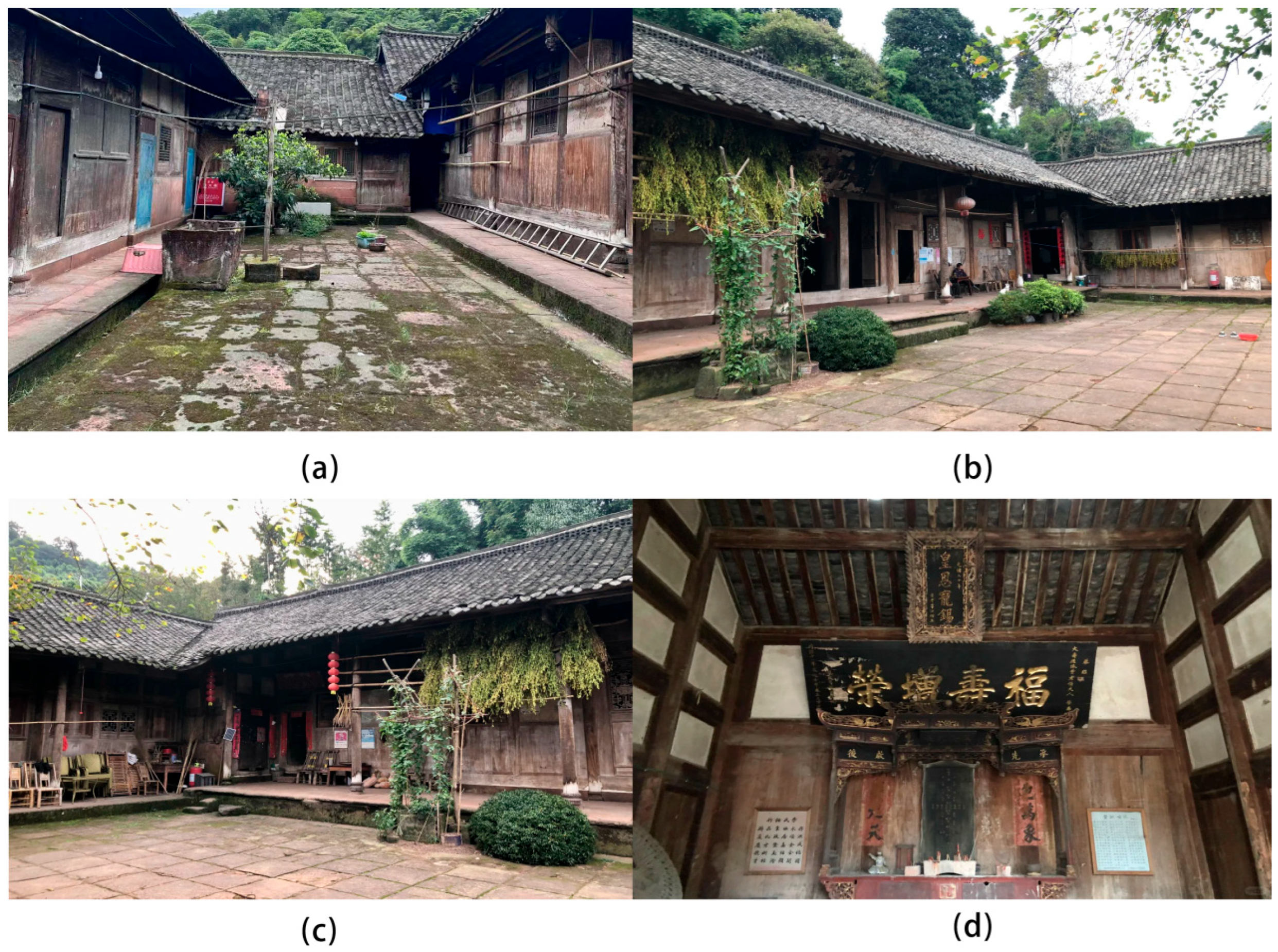
The history of Huaqiu Village can be traced back to the Song Dynasty. At that time, the villagers had already mastered bamboo and wood papermaking techniques, and the paper they produced was widely distributed. During the reign of Emperor Kangxi in the Qing Dynasty, the village gained widespread fame after being bestowed with an imperial plaque inscribed with The Number One Tea Garden under Heaven, and since then, it has become an imperial tea garden for the royal family. As a typical relic of traditional village architecture, the ancient building complex in Huaqiu Village is well-preserved, and the Li Family Compound is the most representative among them. This complex was constructed under the supervision of Hongkai Li, a well-known merchant during the Qing Dynasty. Construction began during the reign of Emperor Xianfeng and lasted 56 years. The entire compound covers more than 13,000 square meters, including 4164 square meters of building area and a total of 149 rooms. The building adopts a traditional mortise and tenon structural system, and the main components are made of wooden materials, which demonstrate the typical characteristics of traditional construction techniques in Southwest China. Decorative arts, such as stone and wood carvings in courtyards, are of high-quality craftsmanship. One courtyard covers an area of 387 square meters, and the ground is paved with 837 bluestones, forming a precise spatial pattern (Figure 2). During the building’s renovation, the principle of minimal intervention was strictly followed to preserve its historical authenticity and avoid altering its original form [42]. For infrastructure renewal, the local area implemented a systematic renovation project. A 4.6 km cement road was constructed; two parking lots were added; water supply and communication pipelines were installed; kitchen, water, and sanitation facilities were upgraded; aging power lines were replaced; a sewage treatment tank was built; and new commercial shops and a health center were established. These practices reflect the strategy of adaptive reuse of heritage sites based on the community’s living needs in the current protection of traditional villages [43].

3.2. Research Method

This research is based on the HUL approach and comprehensively employs various methods, such as spatial analysis techniques, unmanned aerial surveying and mapping, and field investigations, to conduct a study on the protection of the heritage values of Huaqiu Village. The Normalized Difference Vegetation Index (NDVI), Normalized Difference Water Index (NDWI), and Normalized Difference Built-up Index (NDBI) were used not only to monitor individual landscape elements by quantifying the spatial characteristics of vegetation, water bodies, and built structures, but also to reveal the spatial morphological evolution and interactive relationships among these elements within the natural–artificial composite ecosystem through multi-index collaborative analysis [44,45]. The research selected three key time points: 2000 (the original state before being included in the List of Chinese Traditional Villages), 2013 (the start of systematic protection after being included), and 2023 (the in-depth stage of comprehensive protection and multidimensional research). A multi-scale dynamic research system was constructed using spatial analysis tools to quantify the spatial characteristic parameters of the site (Table 1).
The NDVI was calculated using the following formula:
NDVI   =   N I R R e d N I R + R e d
where NIR denotes the near-infrared band (adopting Band 5 of Landsat 7/8 remote sensing images, with a wavelength range of 0.85–0.88 μm). First, we preprocessed the 2000, 2013, and 2023 Landsat remote sensing images (including radiometric calibration and atmospheric correction) to obtain surface reflectance values of the NIR and Red bands. Then, we substituted the reflectance values of each pixel into the formula for pixel-wise calculation. Finally, we clipped the calculated NDVI raster data to the study area using a vector boundary to obtain the village-scale NDVI distribution.
The NDWI was calculated using the following formula:
NDWI   = G r e e n N I R G r e e n + N I R
where Green denotes the green band (adopting Band 3 of Landsat 7/8, with a wavelength range of 0.53–0.59 μm) and NIR denotes the near-infrared band (same as above, Band 5 of Landsat 7/8). We followed the same image preprocessing steps as NDVI to obtain surface reflectance of the Green and NIR bands, applied the formula for pixel-wise calculation, and clipped the result to the village boundary.
The NDBI was calculated using the following formula:
NDBI   =   S W I R N I R S W I R + N I R
where SWIR denotes the shortwave infrared band (adopting Band 6 of Landsat 7/8, with a wavelength range of 1.57–1.65 μm) and NIR denotes the near-infrared band (Band 5 of Landsat 7/8). After preprocessing remote sensing images to obtain SWIR and NIR band reflectance, we calculated the NDBI pixel by pixel using the formula, and clipped the raster data to the study area.
Furthermore, aerial imagery was employed to capture the macro-scale landform evolution process, while field surveys were conducted to document micro-scale spatial details. The drone used was from DJI, mini4k, and surveillance was conducted in April 2025. Field investigations included on-site observations, in-depth interviews, and participatory engagement. These qualitative methods captured cultural details that are often inaccessible through spatial morphological data, helping to reveal the implicit mechanisms and historical contexts of villager–space interactions [46]. Regarding the design of in-depth interview questions, they included but were not limited to the following: 1. Do you reside in Huaqiu Village on a long-term basis? What factors have led you to choose to stay or leave? 2. Could you describe your daily life in Huaqiu Village? Is it interesting or boring, and why? 3. Please evaluate the current state of cultural heritage protection in Huaqiu Village. Are you satisfied with it, and what are the reasons? 4. In your memory, what changes have occurred in the village? What are your opinions on these changes?
Considering the demographic characteristics of Huaqiu Village (with a total of 978 permanent residents and a relatively high proportion of elderly residents), this study adopted a stratified random sampling method to ensure representativeness of the sample. The first stratum corresponds to age groups, aiming to reflect intergenerational differences in heritage perception. The second stratum is defined by occupational or role characteristics, to cover the main stakeholders under the implementation of the HUL approach. From December 2024 to June 2025, a total of 43 interviewees were recruited, ranging from 22 to 63 years old. Their identities included heritage managers, homestay operators, restaurant staff, farmers, and retirees, among others. Braun and Clarke argued that “an adequate sample size is reached when explanations are visible and clear and new findings are not revealed by new informant” [47]. Therefore, the sample size was sufficient to support the final results. For data collection, smartphones with audio recording functionality were used. Recordings were made with the consent of the interviewees, and the publication of relevant identifiable images was also permitted. Eventually, the data were categorized using thematic analysis.
Tengberg et al. argued that heritage value often comprises both natural and cultural attributes, and relying on a single-dimensional assessment can produce biased perceptions of value [48]. Accordingly, we established a systematic heritage value assessment and protection system. This framework allowed for a comprehensive analysis of the interactions between natural foundations and cultural elements in Huaqiu Village. Meanwhile, based on the logical chain of phenomenon identification—mechanism explanation—value confirmation, this study integrated interview data that focuses on villagers’ subjective perception behaviors with quantitative data that emphasizes objective landscape evolution. This is consistent with the core requirements of dynamic and holistic heritage assessment in the HUL approach [4,30]. Ultimately, this study provides data support for extracting experiences of traditional village heritage protection, predicting potential risks, and formulating scientific protection strategies.

4. Results

4.1. Spatial Analysis

Through a comprehensive analysis of the NDVI, NDWI, and NDBI of the remote sensing images of Huaqiu Village from 2000, 2013, and 2023, it is possible to clearly identify the structural changes that have occurred in the mountain–water–forest–farmland–village pattern of this traditional village over the past 23 years. Throughout this transformation, Huaqiu Village exhibited notable spatial differentiation, characterized by a continuous increase in vegetation coverage, westward expansion and eastward contraction of construction land, and ongoing shrinkage of water bodies. Simultaneously, it reflects the game relationship among the urbanization process, residents’ lives, and ecological protection.

4.1.1. Green Space

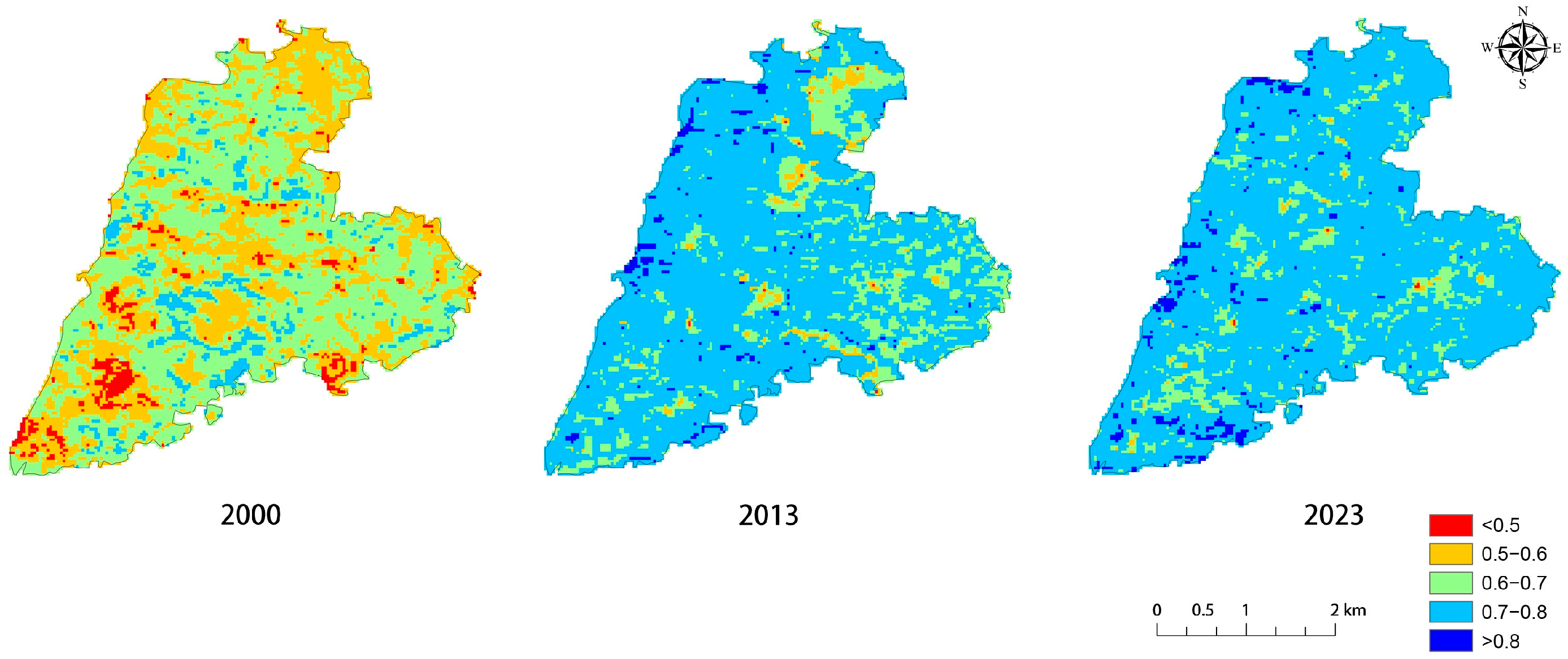
Through a comparative analysis of the NDVI, the research team found that in 2000, the vegetation distribution in Huaqiu Village was primarily characterized by red (<0.5) and yellow (0.5–0.6) areas, while green (0.6–0.7) and light blue (0.7–0.8) areas were sporadically distributed in patches. Overall, vegetation cover was moderate, and human activities had a noticeable impact. For example, the red patches in the central and peripheral areas of the village indicate that building expansion and agricultural activities may have damaged local vegetation. The interlaced distribution of low-vegetation areas (red–yellow) and medium-to-high-vegetation areas (green–light blue) reflects the initial interaction between villagers and the natural ecosystem in the context of traditional agriculture.
By 2013, vegetation in the village showed a significant recovery trend. The high-coverage areas (0.7–0.8) expanded substantially, with light blue becoming the dominant feature. The yellow zone (0.5–0.6) shrank significantly, and the red zone (<0.5) almost disappeared. During this period, the overall vegetation coverage increased and high-vegetation areas were distributed contiguously, indicating a significant improvement in ecological quality. The light-blue areas were continuously distributed at the edge and periphery of the village, whereas the core area of the villagers’ settlements was green, with only a small yellow transition zone (0.5–0.6) remaining in the middle. These changes provide partial confirmation of effective ecological restoration and suggest a social transition from agriculture-dominated livelihoods to ecology-oriented practices.
By 2023, Huaqiu Village achieved full-scale high vegetation coverage, and its ecological pattern became more stable. Vegetation was predominantly blue (>0.8) and light blue (0.7–0.8), with minimal distribution of green (0.6–0.7). Yellow (0.5–0.6) and red (<0.5) areas were extremely rare. At this time, the villagers’ sources of livelihood shifted to green industries such as tea cultivation, ecotourism, and homestay operations. The entire area was primarily covered by blue and light blue vegetation, with only a few green transition zones around the village building complex, forming an ecological pattern in which vegetation was dominant and buildings were less prominent. This signifies that the villagers achieved harmonious coexistence with nature (Figure 3).
Overall, the vegetation cover in Huaqiu Village exhibited the dual characteristics of overall improvement and local degradation. The proportion of areas with high vegetation coverage (>0.7) increased annually, primarily concentrated in the mountainous northern region and the ecological protection zone in the east. This spatial distribution may be related to the local implementation of the policy of returning farmland to forests and the potential influence of traditional feng shui awareness [49,50]. Notably, the average NDVI value in the buffer zone around the core area of the village increased continuously. This phenomenon indicates that the patchwork-style micro-renewal strategy implemented in the fragmented green space may have achieved results [42], and the production and quality of life of villagers have been substantially improved. For instance, as ecological value improved, both the local tea industry and tourism sector developed in parallel, resulting in a favorable scenario of coordinated ecological and economic growth. This refined landscape improvement model, which starts from key points and spreads to the entire area, effectively improves the ecological environmental quality while maintaining the traditional spatial texture of the village, further interpreting the core concept of HUL’s stratified protection [30].

4.1.2. Water Space

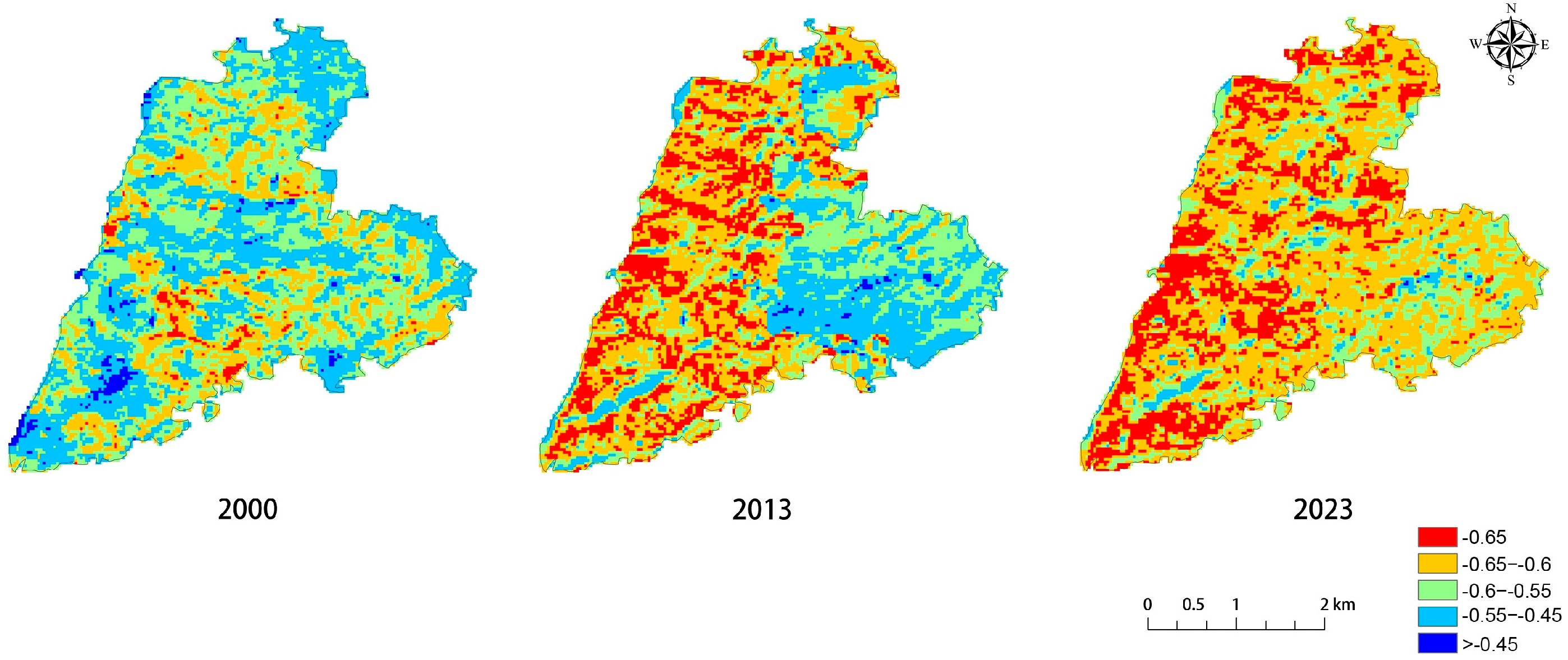
In 2000, light blue (−0.55 to −0.45), blue (>−0.45), and green (-0.6 to −0.55) areas were discretely distributed, primarily concentrated in the central and peripheral areas of Huaqiu Village. In contrast, red (<−0.65) and yellow (−0.65 to −0.6) zones accounted for a significantly larger proportion of the area. During this period, the water bodies in the village were less disturbed by human activities and retained their original form of the natural water system. The spatial pattern of the interlacing of water and non-water areas directly reflects the initial spatial characteristics of the traditional village, where people live along the water. The water system provides basic ecological support and security for the village.
By 2013, the distribution of blue (>−0.45), light blue (−0.55 to −0.45), and green (−0.6 to −0.55) zones significantly declined, while red (<−0.65) and yellow (−0.65 to −0.6) zones expanded substantially. This change was particularly prominent in the western and northern part of the village. The weakening of the waterbody signal intensity and the continuous expansion of non-water types, such as vegetation restoration areas and building-concentrated areas, indicate that the implementation of the policy of returning farmland to forest in ecological protection projects and the land use transformation process caused by villagers’ production and living activities exerted a squeezing effect on the waterbody space. Spatially, non-water areas were continuously distributed in the western region, whereas waterbodies were relatively concentrated in the eastern region. This change may result from reduced surface runoff caused by vegetation restoration or from alterations in water distribution patterns due to irrigation system optimization, both contributing to localized shrinkage of water bodies [51].
In 2023, the blue (>−0.45) and light blue (−0.55 to −0.45) zones had nearly disappeared. Red (<−0.65) and yellow (−0.65 to −0.6) became the dominant types, with only a small amount of green (−0.6 to −0.55) remaining. Water body coverage reached its lowest level, and the water system demonstrated characteristics of reorganization or shrinkage. This may be related to the continuous enhancement of the water-conservation function of vegetation, the increasing demand for water in villagers’ daily lives and production, and the expansion of water use in tourist landscapes [52]. This transformation directly led to a significant increase in the pressure on villagers’ daily water usage. In addition, many former water bodies have been converted into vegetated areas. In the traditional pond–weir system in the eastern part of the village and along the southern stream, the century-old pond–canal–field irrigation network is broken in many places (Figure 4).

4.1.3. Building Space

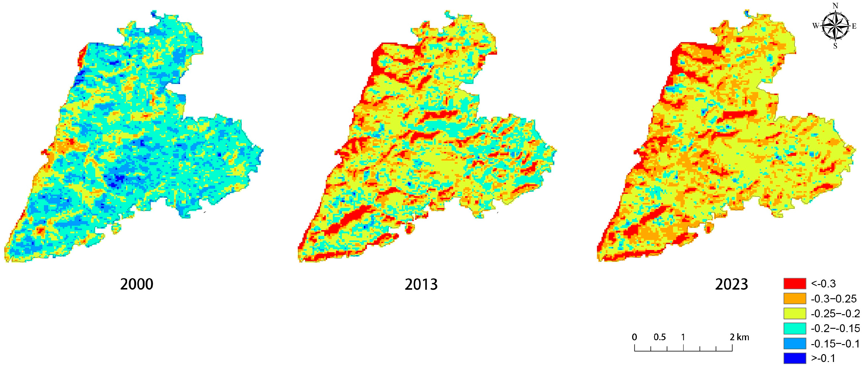
In 2000, building distribution in Huaqiu Village was primarily characterized by green (−0.2 to −0.15) and light blue (−0.15 to −0.1) zones, while red (<−0.3) and yellow (−0.3 to −0.25) zones occupied smaller proportions. At that time, the pace of life was slow, and villagers had lived in the same place for generations. The dense distribution of buildings reflects the collective lifestyle of traditional agricultural society. Due to the village’s remote location, poor transportation, and limited access to information, villagers faced significant constraints on outward mobility.
By 2013, affected by rapid urbanization, young people in the village left their hometowns to seek a living. Many houses were renovated after being vacant for a long time, resulting in a gradual decrease in the building density and decentralized trend in living spaces [53]. During this period, the red (<−0.3) areas in Huaqiu Village expanded significantly, the blue (>−0.1) areas almost disappeared, and the proportion of yellow (−0.3 to −0.25) areas increased substantially. This indicates that the building density in the village demonstrated a gradual downward trend against the backdrop of implementing ecological protection policies.
In 2023, as urbanization continued to increase, the permanent population in the village declined further. The red (<−0.3) and yellow (−0.3 to −0.25) areas in Huaqiu Village became dominant. The once-concentrated settlement pattern was gradually covered by natural vegetation, and buildings were hidden among the mountains and forests. Villagers’ daily lives also shifted from lively neighborhood interactions in the past to a more independent lifestyle (Figure 5).

4.2. Field Investigation

The research team conducted multiple on-site investigations. Using the evaluation scale provided by the Digital Museum of Traditional Chinese Villages, they systematically investigated the village’s current situation in terms of three dimensions: architectural style, spatial layout, and intangible cultural heritage. The scores were assigned according to the score standards and corresponding interpretations set in the scale. The classification criteria were as follows: a score of 90 or above indicated excellent protection; 70 to 89 indicated good protection; 60 to 69 indicated moderate protection; and below 60 indicated inadequate protection [54]. Each research team member scored independently, and the final result was calculated as the average of all individual scores.

4.2.1. Traditional Buildings

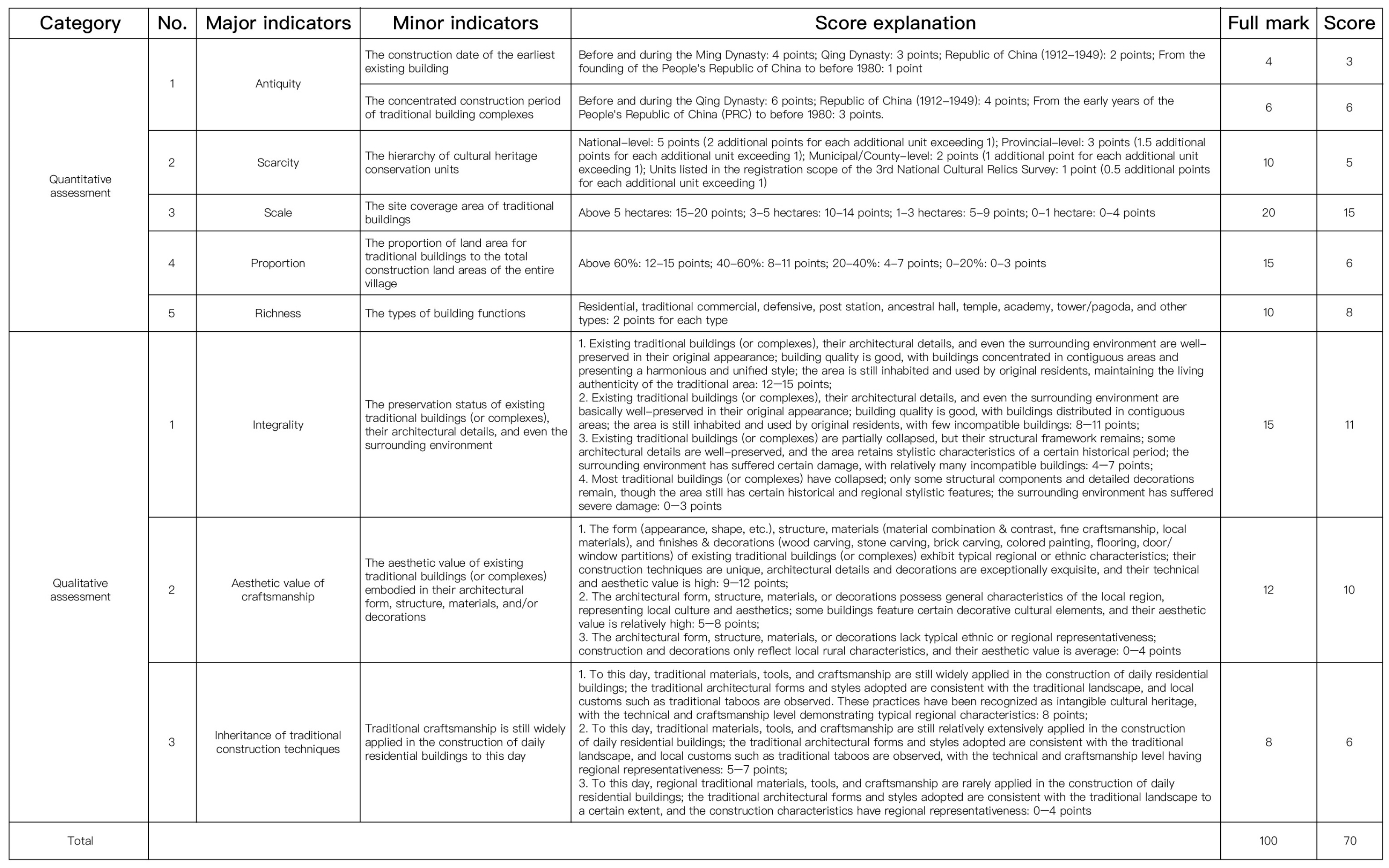
Traditional architecture scored 70 out of 100, indicating a good level of protection (Figure A1). The core of the building complex dates back to the Qing Dynasty and earlier, forming a dense and continuous spatial pattern that imparts a clearly identifiable historical layering and chronological sequence to the village. The village boasts high-level cultural relics, the number of which exceeds the baseline value, further enhancing the uniqueness of its heritage value. In terms of spatial form, both the floor area of traditional architecture and its proportion of the village’s total construction land reached a medium-to-high scale. The settlement’s spatial texture is well-preserved, and the street–alley system remains highly integrated with the surrounding building clusters. There has been no new large-scale destructive construction, and the buildings are still in continuous use by residents, thus creating a living cultural scenario that integrates people, architecture, and the environment.
Huaqiu Village has actively explored the model of living-state protective development. The moderate construction of additional tourism facilities, such as homestays, is carefully regulated to ensure that development intensity remains within thresholds acceptable to local residents. Newly built homestays adhere to the principle of restoring the old to their original state and maintaining harmony with traditional styles in terms of architectural form, material selection, and craftsmanship techniques. This approach effectively enhanced the village’s tourism reception capacity and preserved the spatial integrity of the landscape. At the level of craftsmanship aesthetics, the detailed decorations of traditional architecture, such as woodcarving, brick carving, stone carving, and colored paintings, have exquisite workmanship and distinct regional characteristics, demonstrating a high level of artistic excellence and cultural recognition (Figure 6). Notably, the inheritance of traditional local construction techniques is not interrupted. Elderly craftsmen still use local materials and traditional construction methods in their daily construction activities. Taboos, rituals, and oral traditions associated with these techniques have also been passed down, creating tangible, experiential, and enduring practice spaces for intangible cultural heritage.

4.2.2. Village Site Selection and Layout

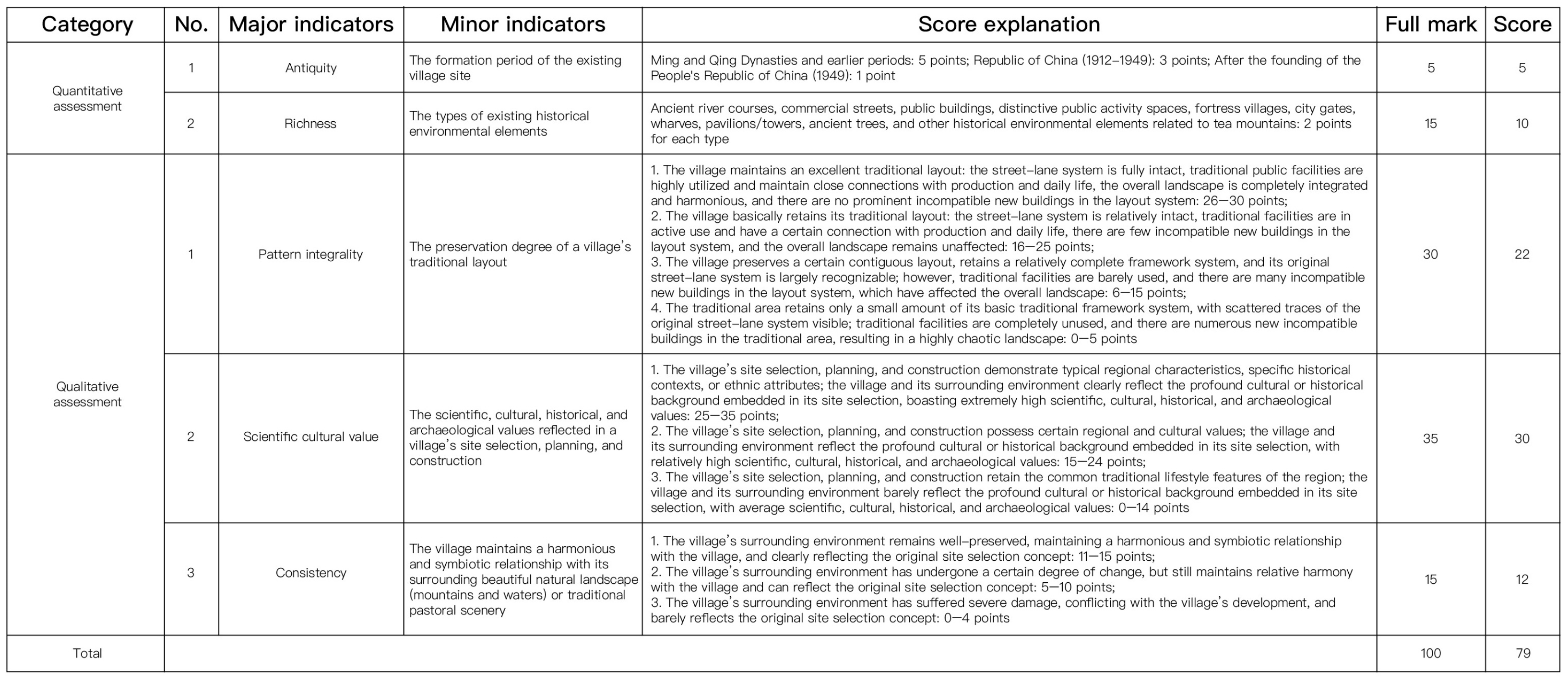
In terms of site selection and layout, the village scored 79 out of 100, indicating an overall favorable and continuously improving state of protection (Figure A2). The village has a long history, and its original settlement texture that formed before the Ming and Qing dynasties remains discernible to this day. Various historical environmental elements, such as ancient river channels, commercial streets, fortresses, and ancient trees, are well preserved. The traditional layout is highly intact, with the street and alley systems remaining continuously connected. Public facilities retain practical use values, and the overall landscape shows a high degree of harmony. Notably, the village maintains a symbiotic relationship with the surrounding natural environment, and traditional principles of site selection continue to be recognized and respected.

4.2.3. Intangible Cultural Heritage

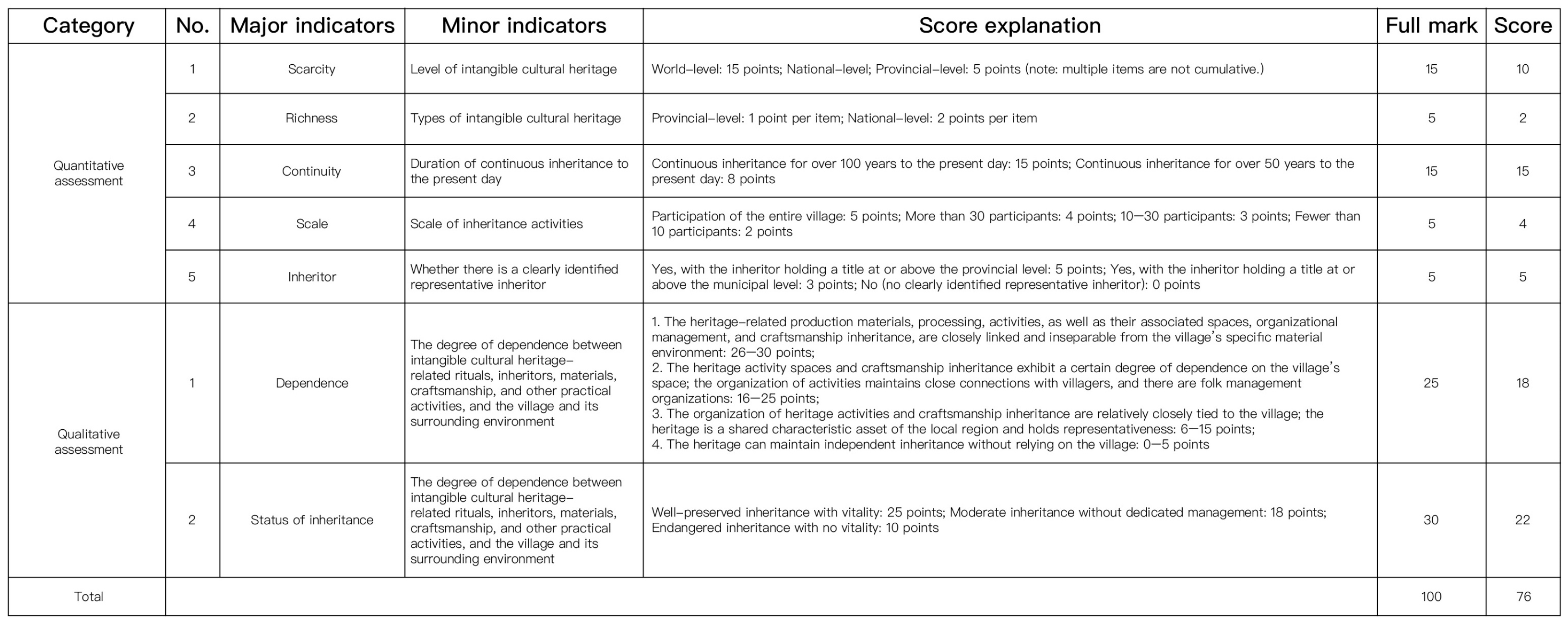
The intangible cultural heritage section scored 76 out of 100, indicating an overall positive and resilient state of existence (Figure A3). Its core characteristics can be summarized as three highs and two strengths. First, the heritage level is high, with items included in both national and provincial representative lists of intangible cultural heritage—many of which possess notable rarity and uniqueness. Second, continuity is high. The inheritance chain of core projects has never been interrupted, and its traceable history spans over a century. Third, the scale scores were high. Village-wide ritual activities were held periodically, with the number of participants consistently exceeding 30. Fourth, the organizational capacity is robust. The system of representative inheritors is well-established, with a clear hierarchical structure of provincial- and municipal-level inheritors, and the operation of folk management organizations is in good order. Fifth, the nature of the living state was strong. Daily production, festival activities, teaching scenarios, and village spaces are deeply integrated. Relevant materials, craftsmanship, and rituals are all completely preserved, presenting a sustainable inheritance picture in which people, objects, and daily life are involved. This creates a positive cycle of intangible cultural heritage protection, resident benefits, and tourism development.
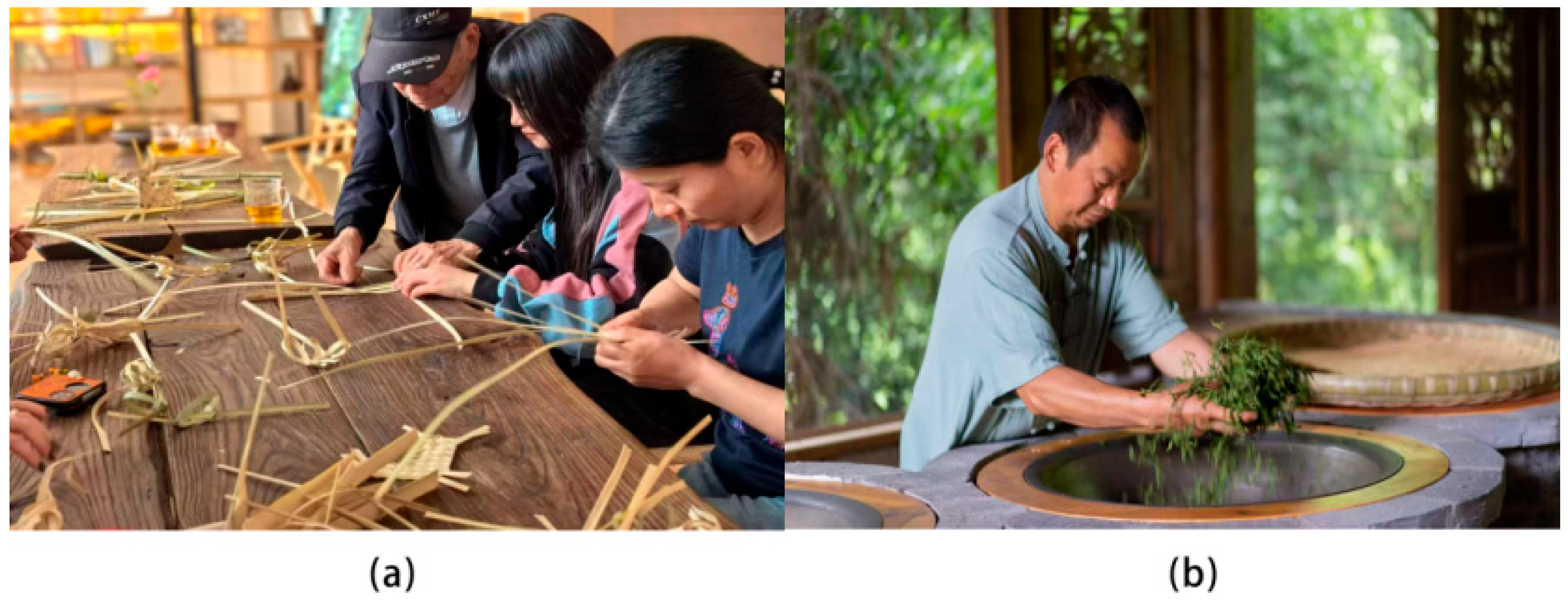
Huaqiu Village further promotes the in-depth integration of intangible cultural heritage into villagers’ lives; this integration is reflected in four dimensions. In terms of clothing, villagers incorporate traditional pattern motifs into contemporary fashion designs, creating cultural and creative products that blend cultural depths with market appeal. This enables traditional craftsmanship to identify new expression carriers in modern life. In the food dimension, ancient cooking techniques continue during festival activities and are further transformed into signature experience projects for agritainment and homestay experiences. As a result, food culture has become an important link between tradition and modernity. In the housing dimension, the core principles of traditional construction were maintained during the restoration of historic residences. Moreover, by optimizing building functions, the accommodation needs of modern tourists are met, achieving a balance between cultural preservation and contemporary utility. In the transportation sector, performance routes for intangible cultural heritage are seamlessly integrated into rural tourism paths, allowing tourists to engage with traditional culture in an organic and immersive manner. Driven by rural tourism, the inheritance of intangible cultural heritage skills has resulted in new economic support, and villagers’ enthusiasm for participation has continued to increase (Figure 7).

4.3. Heritage Value Assessment and Analysis

Villagers in Huaqiu Village continue to promote spatial integration between farmhouse architecture and the surrounding landscape through traditional production practices such as tea cultivation and bamboo–wood processing, which have been passed down through the generations and exhibit dynamic temporal evolution. The assessment path of heritage value based on the social life of local residents is in line with the holistic and hierarchical understanding of heritage value in the Recommendations on Historic Urban Landscape [4,30]. Ancient Chinese society was primarily characterized by a clan system linked by blood relations. The villagers improved their production efficiency, adapted to the natural environment, and improved their living and production conditions through collective labor, thus forming a unique spatial form and set of values. This intergenerational production and lifestyle have promoted a dynamic and mutually constructive relationship between physical space and spiritual values [55]. Specifically, villagers continuously reshape architectural and landscape patterns through daily practices, and these physical carriers, in turn, strengthen their cultural identity and sense of community belonging. This multidimensional interplay among production, daily life, and ecological processes not only embodies the traditional Chinese philosophical concept of harmony between humans and nature but also positions Huaqiu Village as a living heritage site where natural and human elements are deeply intertwined. Therefore, from the perspective of HUL, the value of Huaqiu Village primarily covers three dimensions: landscape, function, and spirit. The following section elaborates on each dimension in detail.

4.3.1. Landscape Value

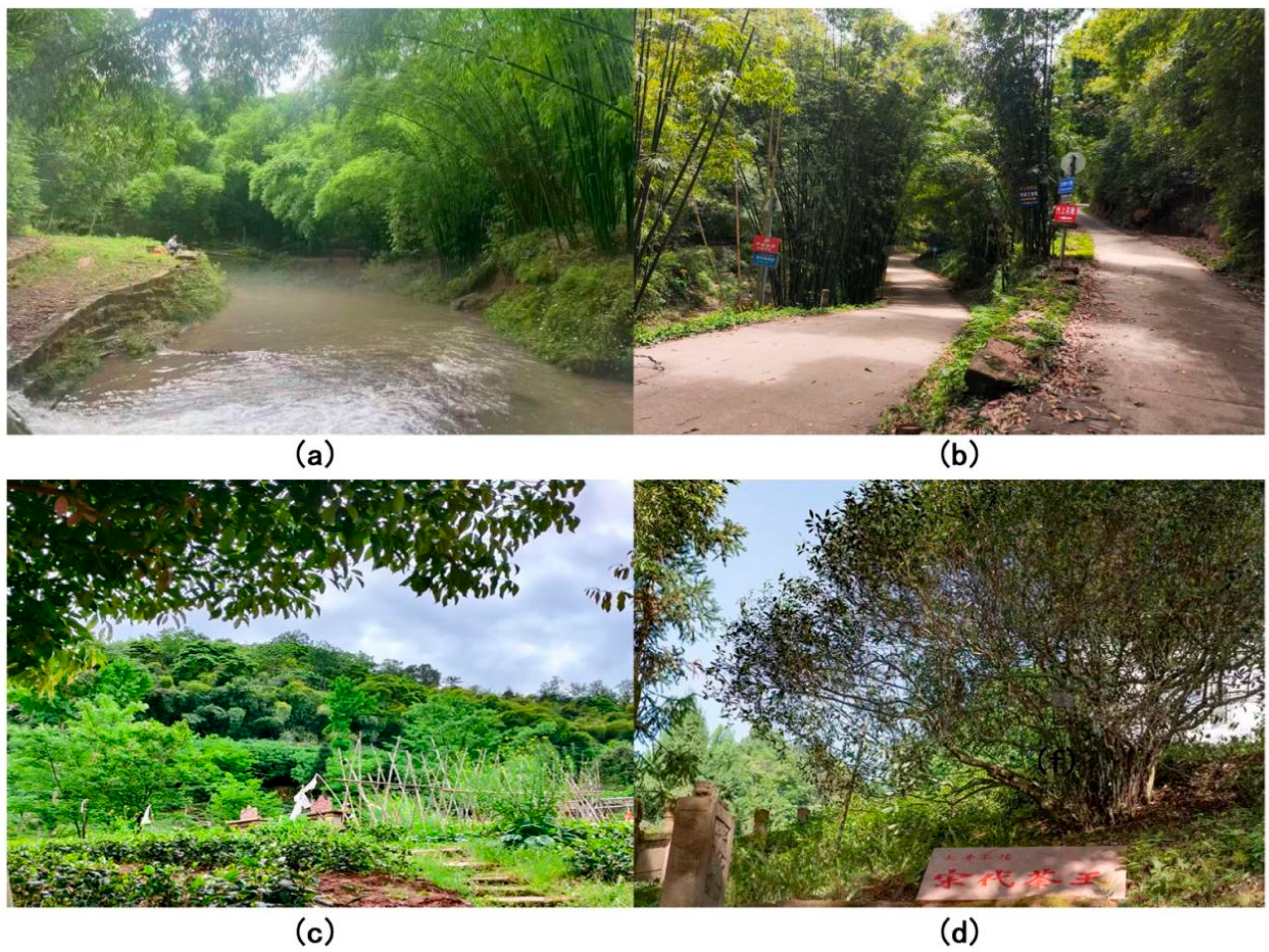
Huaqiu Village is located on a branch of the Longmen Mountains. The entire village features mountainous terrain with steep cliffs on its west side. This location historically served as a vital passage between the Western Sichuan Plain and the mountainous hinterland. From the western cliffs of the village, the landscape opens towards expansive plains and undulating low hills, creating a visually layered terrain. The surrounding fertile fields and mountainous scenery complement each other. The river flows from west to north, encircling the village before turning eastward, creating a spatial form in which mountains and water are in close harmony. The primary carriers of landscape value include water sources, forests, farmlands, and settlements. Huaqiu Village is located at a relatively high altitude. Owing to the combined effects of ecological protection policies and shifts in land use, many water bodies have progressively diminished or vanished, increasing the spatial distance between the village and its primary water sources. Therefore, villagers’ basic livelihoods rely primarily on the water stored in the surrounding forests. These forests provide shelter for daily agricultural activities and biodiversity, as well as necessary production resources. Moreover, natural resources like tea and bamboo provide critical raw materials that enable villagers to sustain and diversify the rural economy. As identified by professional institutions, Huaqiu Village has a well-preserved 866.67-hectare (ten-mile) bamboo forest corridor and an ancient tea tree, aged 1036 years [56]. For a long time, villagers have conducted relatively few large-scale interventions in the natural environment. This positive interaction with nature enabled the aforementioned landscape resources to be completely preserved, thereby maintaining the harmony and stability of the ecosystem (Figure 8).
The HUL theory clearly states that land attachment is a deep-seated connection in the interaction between the community and landscape, reflecting the historical continuity of the landscape [4,57]. For instance, in Japan’s Shirakawa-go Gassho-zukuri village, strong land attachment motivated the community to establish a knot-cooperation system aimed at preserving both architectural structures and traditional water systems. This model was incorporated into the landscape resilience strategy of the HUL [58]. Interviews conducted in Huaqiu Village revealed similar sentiments among elderly residents, reinforcing the notion of deep-rooted land attachment. The spontaneous actions of the community based on attachment can serve as an important supplement to the bottom–up management of HUL.
“My ancestors have lived here for six hundred years, and there has not been much change in the houses and the surrounding environment. Now that I am old, I’ve returned to the village. I grow my own crops and live back in my old house.”
“We have lived here for decades, and there have indeed been changes in the village, such as the improvement of the roads… Now that I am back, I also want to contribute to the village’s improvement.”
“I have lived here for more than 30 years. I never thought about leaving when I was young, and I definitely will not leave now.”

4.3.2. Functional Value

Harbiankova et al. highlighted that functional diversity is a core element of heritage resilience and that conservation efforts should promote the progressive evolution of functions [59]. This perspective aligns with the Nara Document on Authenticity, which asserts that “the continuity and change of functions themselves are also a form of expression of authenticity [60].” The HUL concept does not require absolute preservation of the original authenticity of functions. Instead, it advocates endowing heritage with new uses on the premise of respecting historical context.
In early conservation planning, Huaqiu Village established the goal of developing tourism. However, local government noted that inconvenient transportation, limited public awareness, and inadequate tourism infrastructure were the main barriers preventing tourists from Pingle Ancient Town from visiting Huaqiu [61]. In recent years, in response to national rural revitalization policies, local governments have increased infrastructure investment to enhance transportation and have encouraged villagers to make reasonable improvements to traditional settlements. This move aims to enrich the tourism experience and boost local economic income in the short term while maintaining the long-term vitality of traditional villages. Most villagers support this, reflecting their strong attachment to village life and contributing to the low-impact functional development of the village environment (Table 2). This adaptive adjustment at the functional level to meet the needs of the times is consistent with the core principles of the HUL concept. This perspective was also reflected in interviews with the villagers.
“My family has lived here for generations, and the architectural style has basically remained the same. Now, some tea-break spaces have been added to the compound, and all these handicrafts are handmade by the villagers.”
“These houses were passed down from the previous generation. In the past, they were only used for living, but some have now been transformed into agritainment businesses.”
“Religious stone statues on doors have a long history. In the past, villagers have often held sacrificial ceremonies. Now, they are more likely to receive tourists, and local people’s worship activities are relatively rare.”
Time evolution can reveal the dynamic characteristics of the landscape formation process and its inherent connection to social life [4]. The name of Huaqiu Village originates from an ancient tea tree known as Huaqiu tea. The history of tea cultivation in this village dates back to the Qin and Han dynasties. During the reign of Emperor Kangxi in the Qing Dynasty, Huaqiu tea was selected as a tribute tea because of its excellent quality, which promoted large-scale tea cultivation. Meanwhile, relying on the abundant bamboo resources in the area, the village has gradually developed into the main production area for coarse paper in the Chengdu region. As a result, a traditional settlement centered on the tea and bamboo industries emerged, and this traditional way of life persisted until the end of the 20th century. Urbanization has led many young residents to migrate from the village, resulting in a relatively high proportion of elderly individuals among the permanent population. Although tourism has brought new functional forms to the village, the overall living space retains the traditional style of adapting to and respecting the living habits of the elderly. During the investigation, the research team found that many buildings maintained their original appearances (Figure 9). The functionality of the traditional facilities is undoubtedly weak. However, because these facilities play an irreplaceable role in community life, traditional customs are consistently preserved even as new functions are introduced. Protecting the traditional lifestyle and humanistic atmosphere of the original residents is the essence of the traditional village [62].

4.3.3. Spiritual Value

Spiritual values are not abstract concepts, but are concretely expressed through material carriers, spatial practices, and social memories [4,30,57]. The concept of genius loci, as articulated in the Burra Charter, expands the meaning of heritage from physical structures to encompass dimensions of emotion, memory, and identity. This perspective engages in a theoretical dialog with the traditional Chinese cultural philosophy of the unity of heaven and man and the perception of villages as carriers of nostalgia, essentially revealing a transformation in the field of global heritage conservation from object worship to the pursuit of meaning.
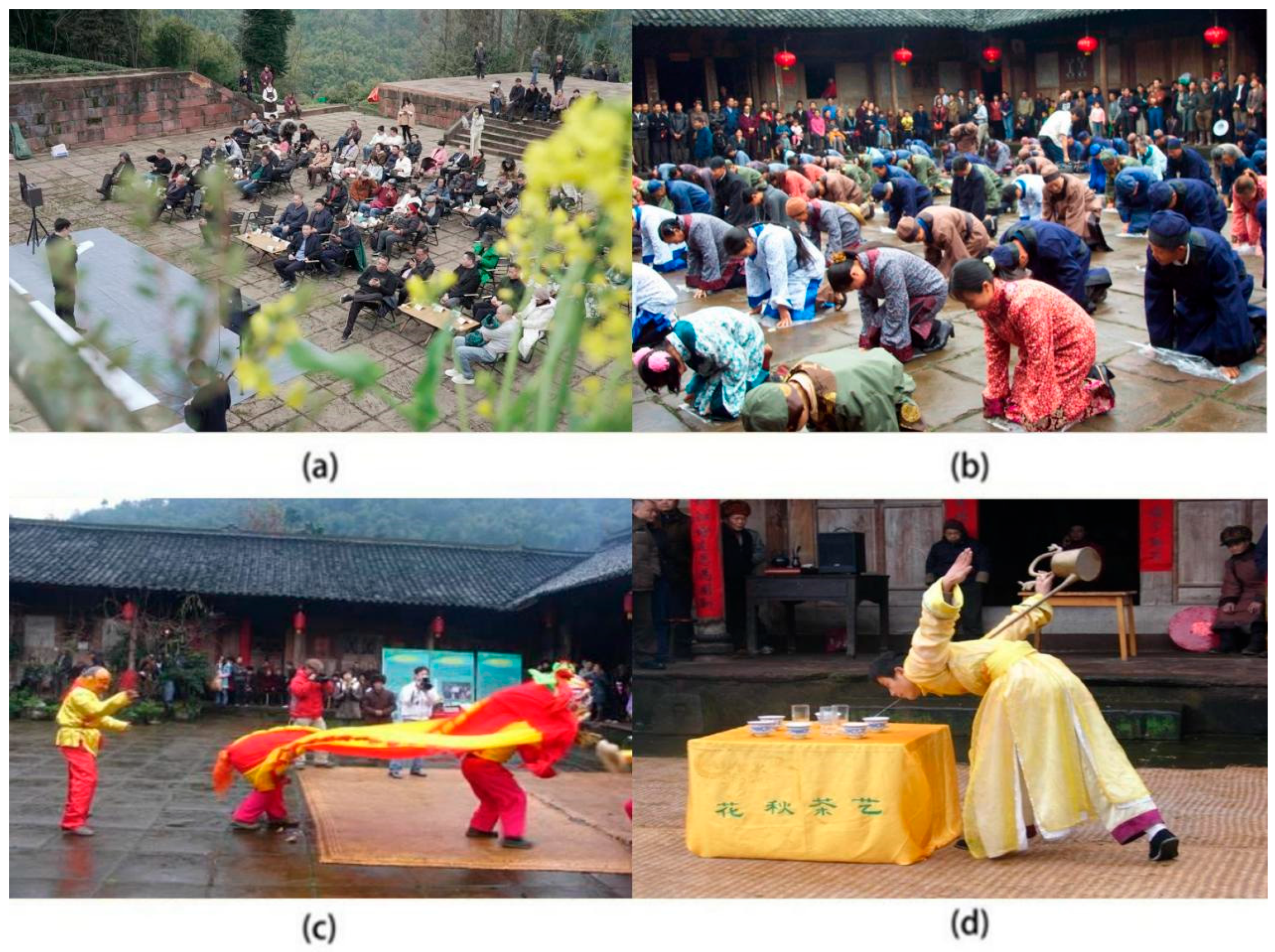
During on-site visits, villagers shared that “every March, Huaqiu Village holds a rural poetry festival, inviting poets from all over to compose poems and exchange verses.” This activity allows the traditional spiritual core of poetry to unite people (enhance group cohesion) and realize the integration of natural landscapes and human emotions, endowing the land with poetic spirituality. In addition, Huaqiu Village retains many characteristic folk activities. The ancestor worship ceremony at the Li Family Courtyard is held every year during the Spring Festival or Tomb-Sweeping Festival. Descendants of the Li family gather to honor their ancestors and express reverence for familial lineage. Zhuma Haozi, originating from ancient papermaking labor, has a rhythm that echoes mountain streams. It not only coordinates the labor rhythm but also provides spiritual comfort to laborers singing. Performances such as lion and ox-shaped lantern dances are conducted in open spaces between tea gardens and residences. The lively drumbeats mingle with the villagers’ laughter, continuously strengthening community cohesion. Among them, tea art performances in Huaqiu are particularly eye-catching. Tea artisans dressed in traditional attire demonstrate the elegance of the tea ceremony through graceful, fluid gestures. These rich and colorful activities are not only carriers of cultural inheritance, but also unique ways for villagers to communicate with nature. The surrounding mountains and waters inspire artistic creativity, serving as expressions of cultural identity and manifestations of the village’s collective values (Figure 10).

5. Discussion

5.1. Summary and Analysis of Key Findings

In the HUL framework, water resources are not merely natural assets but constitute a complex form of heritage that intertwines ecological and cultural dimensions [63]. Even today, water bodies in many historical towns serve functions such as water supply, transportation, and irrigation. However, researchers have found that the water sources in Huaqiu Village are diminishing. Formerly scattered streams and ponds have nearly vanished, and the century-old irrigation network has suffered repeated disruptions. This phenomenon of water body squeezing is not solely caused by natural factors but is the result of multiple human interventions. For instance, ecological policies such as returning farmland to forests have promoted vegetation restoration but have inadvertently encroached on water areas. As Chen and other researchers have confirmed in their study of inland lakes in semiarid regions, large-scale ecological projects may alter surface runoff patterns, leading to the shrinkage of natural water bodies [51]. Concurrent with this, the rise in rural tourism has increased demand for both landscape and domestic water, further intensifying pressure on limited water resources [52]. However, the deeper reason lies in the fact that, in policy discourse, water is simplified as an ecological indicator, overlooking its cultural status in traditional agriculture.
The irrigation system maintains the production rhythm of the village and serves as a spatial carrier of feng shui beliefs and festival ceremonies [64,65]. In China, the spatial pattern of mountains, waters, forests, farmlands, and villages embodies the philosophical concept of harmony between humans and nature, with water serving as the lifeline connecting the natural ecosystem and human production [6]. In Huaqiu Village, where tea planting and bamboo and wood processing are the traditional means of livelihood, the reduction in water not only affects agricultural practices but also erodes water-related cultural memories. Bandarin and van Oers emphasized that as a carrier of both ecological functions and historical memories, the water system should be regarded as the core element for overall protection [66]. Ignoring the cultural dimensions of waterbodies is equivalent to eliminating landscape memories. To address this issue, future strategies must establish a red line for water culture. To evaluate projects for returning farmlands to forests, an indicator of the integrity of traditional water systems should be added. Hierarchical documentation should be established for ponds and weirs over a century old, and community water cooperatives should be introduced to enable villagers to retain the rights of management and ritual use of water sources. Most importantly, the cultural value of water must be reaffirmed through the recording of oral histories, the restoration of traditional water-related rituals, and the integration of water elements into cultural tourism initiatives. These efforts can help rebuild the emotional bonds between villagers and their water heritage.
There is also a phenomenon worthy of attention in Huaqiu Village. The characteristics of the adaptive changes were clearly discernible. The transformation of traditional courtyards into homestays, the construction of cement roads, and the promotion of cultural and tourism industries fall into this category. In contrast, many historical elements remain stable, which is mainly reflected in the preservation of architectural styles, continuation of traditional lifestyles, and the inheritance of ancestral worship ceremonies. This coexistent change and permanence confirm the concept of respecting and protecting the dynamic landscape accumulated layer-by-layer, as advocated by HUL [30]. Here, change is not an unrestrained form of destruction but a necessary adjustment to meet contemporary living needs. Research shows that the transformation of Li family compounds from a single-function living space to a composite space of living commerce and culture not only enhances the village’s tourism reception capacity but also endows traditional buildings with new vitality. Improvements in infrastructure, such as road construction and sewage treatment, are not only a response to the villagers’ demand for improved quality of life but also a necessary measure to retain villagers and safeguard the cultural atmosphere. These interventions ensure that the village functions as a living heritage site rather than a static museum exhibit, which echoes the theory of gradual functional evolution Harbiankova [60]. Meanwhile, the preservation of historic house forms, ancestor worship routes, and neighborhood scales is in line with the main idea of the Nara Document on Authenticity [61]. The stability of core elements provides a foundation for sustaining cultural identity. Its core heritage value lies in the integration of its natural and humanistic attributes. The stability of core elements ensures that cultural memories and identities contained in the landscape are not lost during the process of change [48]. This dialectical relationship between change and unchangeability intuitively reflects the balance achieved by traditional villages in adapting to the modernization process.
Among the three evaluation dimensions, Huaqiu Village achieved a relatively high score (76 out of 100) for intangible cultural heritage. This outcome is not coincidental; rather, it stems from a protection strategy centered on community participation, which integrates heritage elements deeply into everyday social life. As HUL emphasizes, the value of heritage is the product of dynamic interactions between tangible and intangible elements, and community residents are key participants in this interaction process [11]. Specifically, Huaqiu’s bamboo-weaving culture is not confined to museums but is actively incorporated into the design of cultural and creative products within homestays. Traditional tea-frying techniques have been integrated into agro-tourism experience projects. Activities such as rural poetry festivals and tea art performances frequently appear in the daily lives of villagers and the tourism scenarios of visitors. In the context of the experience economy, this integration into the daily life model effectively prevents the marginalization of intangible cultural heritage.
A key contributor to this vitality is Huaqiu’s multi-level inheritance system. You Wei, a provincial-level inheritor of bamboo weaving, Luo Caixun, a municipal-level inheritor of Zhuma Haozi, and several well-organized folk organizations have jointly formed a complete inheritance chain. The township cultural station undertakes daily management tasks, such as the census, registration of intangible cultural heritage sites, and filing of activities. The intangible cultural heritage protection center provides standardized guidance for inheritance activities by formulating Protection Specifications for Traditional Skills. Survey data indicated that the traditional skills training institute in Huaqiu Village regularly conducts weekend sessions, training more than 30 young inheritors annually. The villagers’ cultural association is responsible for planning regular activities such as rural poetry festivals and tea art performances, organizing more than 12 intangible cultural heritage exhibition activities on average each year. This operational framework aligns with the principle of collaborative governance among multiple stakeholders as advocated by the HUL [4,36]. Clear responsible entities and sound institutional guarantees can prevent the inheritance chain from breaking down. More importantly, the economic benefits of tourism development have increased villagers’ enthusiasm for participating in the inheritance. When traditional skills improve livelihoods, inheritance changes from passive to active choice [56].

5.2. Comparison with Existing Studies: Validation of Rationality and Innovation

This study conducted a systematic evaluation of the heritage value of Huaqiu Village based on the HUL approach. In terms of spatial form analysis, this study shares similarities with the GIS-based analysis of the Amazon forest islands and large-scale raised fields in Bolivia carried out by scholars such as Lee, T.W. Both studies use landscape pattern indices to quantify spatial characteristics [67,68,69,70]. However, this research extends the methodology by incorporating multitemporal remote-sensing data, enabling analysis of the spatiotemporal coupling mechanism between vegetation restoration and water system shrinkage across different years. This finding addresses the limitations of existing research, as most studies focus on the analysis of architectural forms, such as building layouts and street textures, paying relatively little attention to ecological processes and overlooking the correlation between ecological elements, such as vegetation and water systems, and the evolution of urban spatial forms [71,72]. With respect to the heritage protection evaluation, this study deepens the application of a dynamic evaluation model. Jiang et al. highlighted that current heritage evaluations are mostly limited to static considerations at a certain point in time and lack a dynamic evaluation method for the entire process of protection and utilization [73]. In response, this study not only adopts a three-dimensional classification framework of landscape–function–spirit, but also verifies the actual effects of protection measures through time-series analysis. This dynamic evaluation model enables real-time tracking of heritage changes over time and assesses the effectiveness of protection measures, addressing key limitations of static evaluation models, which are unable to respond to evolving conditions or inform timely adjustments to protection.
Prior to this study, the HUL approach lacked a systematic rural-adaptable paradigm. Existing rural-related HUL research only applied fragmented HUL principles without integrating the framework’s core dynamic layered protection and tangible–intangible synergy concepts. Our study fills the gap by: (1) Verifying that HUL’s dynamic cumulative logic is applicable to rural heritage—for example, demonstrating how westward expansion of built-up areas (new homestay) and preservation of core historical buildings (Li Family Compound) coexist to maintain heritage continuity; and (2) Proposing a natural-cultural dual-layer extension of the HUL framework for rural contexts. This layer integrates ecological elements (water bodies, vegetation) that are rarely emphasized in urban HUL studies, addressing the discipline’s long-standing neglect of rural natural–cultural coupling.
Existing rural heritage studies often rely on single data types. Our study innovates by constructing a multi-scale, multi-source data integration method: (1) Landsat remote sensing data to analyze landscape evolution over 23 years; (2) DJI drone data to capture details of local landscape layout and distribution; and (3) stratified random interview data to supplement cultural perception. This integration avoids the one-sidedness of single-data studies. For example, using NDWI data to confirm water body shrinkage, then using questionnaire responses to explain its cultural impact, forming a complete phenomenon–mechanism–value evidence chain.

5.3. Theoretical Significance and Practical Application Value

In summary, the significance of this study is reflected in three aspects: theory, practice, and methodology. Traditional heritage protection paradigms primarily focus on the protection of static material entities, and the HUL method has long been inclined towards the field of urban heritage, with a relatively lagging theoretical and practical exploration of rural heritage. This study systematically introduces the HUL method to Huaqiu Village, emphasizing that heritage value is the dynamic accumulation of tangible and intangible elements, and analyzes the three-dimensional values of landscape, function, and spirit in combination with the social life of local residents, verifying the applicability of the HUL method in rural scenarios. This exploration expands the scope of HUL theory and enriches the value-recognition framework for living heritage in traditional villages by overcoming previous limitations associated with single-dimensional evaluations focused solely on either material or cultural aspects. In addition, traditional villages generally face problems, such as the breakage of cultural genes, fragmentation of historical landscapes, and contradictions between development and protection. Through an empirical study of Huaqiu Village, this paper proposes strategies such as dynamic cumulative protection, community-participatory value assessment, and synergy between ecology and humanity, providing an operational reference paradigm for the protection of traditional villages. Finally, spatial analysis technology, unmanned vehicle aerial photography, and field surveys were integrated to construct a multi-scale dynamic research system.
Huaqiu Village’s heritage conservation also provides critical support for urban landscape sustainability in the Chengdu metropolitan area. Ecologically, the village’s 80% green coverage and ten-mile bamboo forest corridor act as a green lung for nearby urban areas, regulating microclimates and reducing urban heat island effects—this is an important part of regional ecological sustainability. Culturally, the village’s intangible heritage and historical landscape provide urban residents with a cultural counterbalance to rapid urbanization, satisfying urban demand for traditional cultural experiences and promoting cultural sustainability of the entire urban–rural system. Economically, the village’s low-impact tourism model creates a sustainable urban–rural tourism chain, avoiding the ecological and cultural risks of large-scale urban tourism development. These contributions reflect that rural heritage conservation is not an isolated practice, but an important component of urban–rural integrated sustainability.

6. Conclusions

Based on the HUL theoretical framework, this study integrates multiple methods—spatial analysis, drone aerial mapping, and field surveys—to explore the adaptability and application path of the HUL approach in Huaqiu Village. The aim was to provide practical references for constructing a highly adaptable and replicable protection and development plan for traditional villages. The generation of heritage value stems from a continuous interactive process between human activities and physical space. By analyzing the landscape evolution and value composition of Huaqiu Village, this study reveals the patterns of living-state inheritance within the integrated natural–humanistic system of traditional villages. The research results show that in the past two decades, Huaqiu Village has exhibited spatial evolution characteristics, including a continuous increase in vegetation cover, westward expansion and eastward shrinkage of construction land, and continuous shrinkage of the water area. Its heritage value exhibits collaborative characteristics in three dimensions: landscape, function, and spirit.
The application of the HUL approach to Huaqiu Village demonstrated strong adaptability. By analyzing the dialectical relationship between change and constancy, this study verifies the effectiveness of the concept of dynamic layered protection, among which community participation as the core principle has achieved significant results. This study further confirms that the protection of traditional villages needs to strengthen the multiparty collaboration mechanism and promote the in-depth participation of stakeholders in the formulation and implementation of protection plans. As a typical case of traditional villages in the mountainous areas of western Sichuan, Huaqiu Village shows that the HUL method has great potential for application in rural heritage protection. The significance of this study lies in overcoming the urban bias of HUL theory, enriching the conceptual framework for recognizing rural living heritage, and providing a practical and operable model for the protection and development of similar villages. Future research needs to further explore the roles and impacts of stakeholders in decision-making, deepen the localization adaptation of the HUL method, and simultaneously promote the establishment of a special mechanism covering the protection of the cultural value of water systems to help traditional villages become models for sustainable rural development and cultural diversity protection.
However, this study has several limitations. As a traditional village in a specific region, the research conclusions from Huaqiu Village may not be directly applicable to other types of villages. Future research should enhance the universality of theory and practice through multi-case comparisons, long-term monitoring, and cross-cultural validation. Additionally, since the time series images were taken in the same season, future research needs to further explore seasonal effects.

Author Contributions

Conceptualization, X.H.; methodology, X.H.; software, X.H., W.Z. and R.L.; validation, X.H., X.C. (Xinyang Cai) and X.C. (Xinyue Chen); formal analysis, X.H., X.C. (Xinyue Chen) and R.L.; investigation, X.C. (Xinyang Cai), X.C. (Xinyue Chen), W.Z. and R.L.; resources, X.H. and T.Y.; data curation, X.H. and T.Y.; writing—original draft preparation, X.H., X.C. (Xinyang Cai) and X.C. (Xinyue Chen); writing—review and editing, X.H.; visualization, X.H., X.C. (Xinyang Cai), W.Z. and R.L.; supervision, X.H.; project administration, X.H.; funding acquisition, X.H. All authors have read and agreed to the published version of the manuscript.

Funding

This research was funded by the Talent Introduction Program of Xihua University (w2420109) and Chengdu Philosophy and Social Sciences Beautiful Rural Construction and Development Research Center (CCRC2024-12).

Institutional Review Board Statement

The research was approved by the Ethics Committee of the School of Art and Design, Xihua University, China.

Informed Consent Statement

Written informed consent has been obtained from the participants to publish this paper.

Data Availability Statement

Requests to access the datasets should be directed to the correspondent author.

Acknowledgments

We sincerely express our heartfelt gratitude to the Party-Mass Service Center of Huaqiu Village, Zhushang Huaqiu Yeshe Art Homestay, Xiaoma’s Wilderness Bookstore, and Nelson for providing various support for this research, including literature materials and coordination of communication with villagers.

Conflicts of Interest

The authors declare no conflicts of interest.

Abbreviations

The following abbreviations are used in this manuscript:
HULHistoric urban landscape
NDVINormalized difference vegetation index
NDWINormalized difference water index
NDBINormalized difference built-up index
UNESCOUnited Nations Educational, Scientific and Cultural Organization
ETM+Enhanced Thematic Mapper
TIRSThermal Infrared Sensor
NIRNear-Infrared
SWIRShort-Wavelength Infrared

Appendix A

Figure A1. Evaluation of the current state of traditional buildings in Huaqiu Village.
Sustainability 17 08981 g0a1
Figure A2. Evaluation of the current state of Huaqiu Village site selection and layout.
Sustainability 17 08981 g0a2
Figure A3. Evaluation of the current state of intangible cultural heritage in Huaqiu Village.
Sustainability 17 08981 g0a3

References

  1. He, Y.; Zhang, T.; Xiong, D. Evaluation on cultural value of traditional villages and differential revitalization: A case study of Jiaozuo City, Henan Province. Econ. Geogr. 2020, 40, 230–239. [Google Scholar] [CrossRef]
  2. Katapidi, I. Heritage policy meets community praxis: Widening conservation approaches in the traditional villages of central Greece. J. Rural. Stud. 2021, 81, 47–58. [Google Scholar] [CrossRef]
  3. Liu, D.; Hu, J.; Chen, J. The study of spatial distribution patterns of traditional villages in China. Chin. Popul. Res. Environ. 2014, 24, 157–162. [Google Scholar]
  4. Li, J.; Wang, J.; Li, X. Heritage value assessment and landscape preservation of traditional Chinese villages based on the daily lives of local residents: A study of Tangfang Village in China and the UNESCO HUL Approach. Land 2024, 13, 1535. [Google Scholar] [CrossRef]
  5. Naheed, S.; Shooshtarian, S. The role of cultural heritage in promoting urban sustainability: A brief review. Land 2022, 11, 1508. [Google Scholar] [CrossRef]
  6. Shi, X.; Beza, B.B.; Liu, C.; Wu, B.; Qiu, N. Differences in perspectives between experts and residents on living heritage: A Study of traditional Chinese villages in the Luzhong Region. Buildings 2024, 14, 4022. [Google Scholar] [CrossRef]
  7. Feng, T. Analysis of the protection and development issues of traditional villages in Mianyang, Sichuan. China Natl. Cond. Strength 2022, 9, 40–43. [Google Scholar] [CrossRef]
  8. Zeayter, H.; Mansour, A.M.H. Heritage conservation ideologies analysis—Historic urban landscape approach for a Mediterranean historic city case study. HBRC J. 2018, 14, 345–356. [Google Scholar] [CrossRef]
  9. Wang, X.; Zhu, Q. Influencing Factors of traditional village protection and development from the perspective of resilience theory. Land 2022, 11, 2314. [Google Scholar] [CrossRef]
  10. Tsenkova, S. Sustainable housing and liveable cities: European habitat & The New Urban Agenda. Urban Res. Pract. 2016, 9, 322–326. [Google Scholar] [CrossRef]
  11. Fekete, A.; Herczeg, Á.; Ge, N.D.; Sárospataki, M. participatory landscape design and water management—A sustainable strategy for renovation of vernacular baths and landscape protection in Szeklerland, Romania. Land 2022, 11, 95. [Google Scholar] [CrossRef]
  12. Lin, Y.; Chen, J.F. From the perspective of historical urban landscape layering, strategies for protecting ancient towns: A case study of Chikan Ancient Town in Jiangmen City. China Urban Planning Society People’s City, Planning Empowerment. In Proceedings of the 2023 China Urban Planning Annual Conference (18 Small Town Planning), Hangzhou, China, 5–8 July 2024; Guangzhou Urban Planning Survey and Design Research Institute: Guangzhou, China, 2023. [Google Scholar]
  13. Li, X.; Zhou, X.; Weng, F.; Ding, F.; Wu, Y.; Yi, Z. Evolution of cultural landscape heritage layers and value assessment in urban countryside historic districts: The case of Jiufeng Sheshan, Shanghai, China. Herit. Sci. 2024, 12, 96. [Google Scholar] [CrossRef]
  14. Wu, J.; Zhang, Y. A review of research on the perception of attachment to historical sites in traditional villages from the perspective of multiple subjects. Archit. Cult. 2024, 5, 55–57. [Google Scholar]
  15. Bandarin, F.; Van Oers, R. The Historic Urban Landscape: Managing Heritage in an Urban Century; Tongji University Press: Shanghai, China, 2017; pp. 30–35. [Google Scholar]
  16. Rodwell, D. The Values of Heritage: A New Paradigm for the 21st Century. In From Postwar to Postmodern—20th Century Built Cultural Heritage; The 6th Baltic Sea Region Cultural Heritage Forum; Riksantikvarieämbetet: Stockholm, Sweden, 2017; p. 99. [Google Scholar]
  17. Tu, L. Optimization of heritage management mechanisms through the prism of historic urban landscape: A case study of the Xidi and Hongcun World Heritage Sites. Sustainability 2024, 16, 5136. [Google Scholar] [CrossRef]
  18. CIAM. The Athens Charter; CIAM: Patris, Athens, 1933. [Google Scholar]
  19. ICOMOS. The Venice Charter for the Conservation and Restoration of Monuments and Sites; ICOMOS: Venice, Italy, 1964. [Google Scholar]
  20. Li, W.; Zhang, X.; Zhong, J.; Zhu, Y. Research on the paradigm of traditional villages protection based on dynamic integrity. Urban Dev. Stud. 2024, 31, 8–13+33. [Google Scholar]
  21. Qian, X.; Yu, Y.; Liu, R. The spatial relationship characteristics and differentiation causes between traditional villages and intangible cultural heritage in China. Buildings 2025, 15, 2094. [Google Scholar] [CrossRef]
  22. Hu, Y.; Chen, S.; Cao, W.; Cao, C. The concept and cultural connotation of traditional villages. Urban Dev. Stud. 2014, 21, 10–13. [Google Scholar]
  23. Wu, C.; Chen, M.; Zhou, L.; Liang, X.; Wang, W. Identifying the spatiotemporal patterns of traditional villages in China: A multiscale perspective. Land 2020, 9, 449. [Google Scholar] [CrossRef]
  24. Chang, R.; Wang, J.; Li, L.; Chen, D. Extraction and analysis of the spatial morphology of a heritage village based on digital technology and weakly supervised point cloud segmentation methods: An innovative application in the case of Xisongbi Village in Jiexiu City, Shanxi Province. Sustainability 2025, 17, 3349. [Google Scholar] [CrossRef]
  25. Liu, P.; Deng, Y.; Lin, M.; Zhang, C. A new approach to protecting historical and cultural towns and villages. Contemp. Soc. Sci. 2018, 3, 86–96. [Google Scholar] [CrossRef]
  26. China Social Sciences Network. Ethical Reflections on the Digital Preservation of Intangible Cultural Heritage. Available online: https://www.cssn.cn/zkzg/zkzg_gxzkdzyx/zkzg_gxdzyx_yc/202505/t20250519_5874570.shtml (accessed on 1 June 2025).
  27. Hu, Y.; Zheng, F. Digital memory construction in Lijiang. Digit. Transform. Soc. 2024, 3, 376–394. [Google Scholar] [CrossRef]
  28. Council of Europe. European Landscape Convention; Council of Europe: Florence, Italy, 2000. [Google Scholar]
  29. Zhang, W.; Han, F. A review of the theoretical and practical research on historic urban landscape. Landsc. Archit. 2017, 24, 22–28. [Google Scholar] [CrossRef]
  30. UNESCO. Recommendation on the Historic Urban Landscape; UNESCO: Paris, France, 2011. [Google Scholar]
  31. Jiang, J.; Zhou, T.; Han, Y.; Ikebe, K. urban heritage conservation and modern urban development from the perspective of the historic urban landscape approach: A case study of Suzhou. Land 2022, 11, 1251. [Google Scholar] [CrossRef]
  32. Bandarin, F.; Van Oers, R. The historic urban landscape: Managing heritage in an urban century. Urban Morphol. 2013, 17, 73–74. [Google Scholar] [CrossRef]
  33. Ma, S. Research on the Protection Planning of Traditional Villages with Artistic Characteristics in Regong from the Perspective of Historic Townscape (HUL). Master’s Thesis, Chang’an University, Xi’an, China, 2023. [Google Scholar]
  34. Zhang, X. Analysis of Landscape Imagery and Protection Strategies of Qingcheng Ancient Town, Lanzhou. Master’s Thesis, Fujian Agriculture and Forestry University, Fuzhou, China, 2024. [Google Scholar]
  35. Wu, J. Place Attachment and Landscape Improvement of Historical Places in Hui’gang Traditional Village of Hangzhou: Based on Multiple Stakeholders’ Perspective. Master’s Thesis, Zhejiang University, Hangzhou, China, 2023. [Google Scholar]
  36. Sari, K.E.; Antariksa, M.; Keppi, S. The Development of HUL (Historic Urban Landscape) concept for community based conservation in Surabaya City. Evergreen 2024, 11, 1125–1135. [Google Scholar] [CrossRef]
  37. Macamo, S.; Raimundo, M.; Moffett, A.; Lane, P. Developing heritage preservation on Ilha de Moçambique using a historic urban landscape approach. Heritage 2024, 7, 2011–2030. [Google Scholar] [CrossRef]
  38. Juma, M.; Turner, M. Reshaping Urban Conservation: The Historic Urban Landscape Approach in Action; Springer: Singapore, 2019; pp. 529–543. [Google Scholar]
  39. Lux, M.S.; Tzortzi, J.N. From thermal city to well-being landscape: A Proposal for the UNESCO Heritage Site of Pineta Park in Montecatini Terme. Heritage 2025, 8, 123. [Google Scholar] [CrossRef]
  40. Cunha Ferreira, T.; Rey-Pérez, J.; Pereira Roders, A.; Tarrafa Silva, A.; Coimbra, I.; Breda Vazquez, I. The historic urban landscape approach and the governance of world heritage in urban contexts: Reflections from Three European Cities. Land 2023, 12, 1020. [Google Scholar] [CrossRef]
  41. China News Network. Huaqiu Village in Qionglai City is Listed in the National List of Traditional Chinese Villages. Available online: https://www.chinanews.com.cn/cul/2015/01-27/7009561.shtml (accessed on 10 March 2025).
  42. Wang, J.; Wu, Z.; Zhou, Z. Study on the status quo and development of traditional village protection: A case study of Huaqiu Village, Pingle Town, Qionglai City. Value Eng. 2019, 38, 109–110. [Google Scholar] [CrossRef]
  43. Niković, A.; Manić, B.; Čolić Marković, N.; Krunić, N. A contribution to the integration of international, national and local cultural heritage protection in planning methodology: A case study of the Djerdap Area. Land 2024, 13, 1026. [Google Scholar] [CrossRef]
  44. Ali, A.; Hussain, B.; Hissan, R.U.; Al Aiban, K.M.; Radulescu, M.; Magazzino, C. Examining the landscape transformation and temperature dynamics in Pakistan. Sci. Rep. 2025, 15, 2575. [Google Scholar] [CrossRef] [PubMed]
  45. Onyango, D.O.; Opiyo, S.B. Detection of historical landscape changes in Lake Victoria Basin, Kenya, using remote sensing multi-spectral indices. Watershed Ecol. Environ. 2022, 4, 1–11. [Google Scholar] [CrossRef]
  46. Bürgi, M.; Russell, E.W. Integrative methods to study landscape changes. Land Use Policy 2001, 18, 9–16. [Google Scholar] [CrossRef]
  47. Braun, V.; Clarke, V. Using thematic analysis in psychology. Qual. Res. Psychol. 2006, 3, 77–101. [Google Scholar] [CrossRef]
  48. Tengberg, A.; Fredholm, S.; Eliasson, I.; Knez, I.; Saltzman, K.; Wetterberg, O. Cultural ecosystem services provided by landscapes: Assessment of heritage values and identity. Ecosyst. Serv. 2012, 2, 14–26. [Google Scholar] [CrossRef]
  49. Fan, T. Analysis of the Effects and Problems of Converting Farmland to Forest: Taking Qionglai for an Example. Cent. South For. Inventory Plan. 2006, 3, 29–31+34. [Google Scholar]
  50. Mak, M.Y.; Ng, S.T. The art and science of Feng Shui—A study on architects’ perception. Build. Environ. 2005, 40, 427–434. [Google Scholar] [CrossRef]
  51. Chen, X.; Wang, Y.; Pei, H.; Guo, Y.; Zhang, J.; Shen, Y. Expansion of irrigation led to inland lake shrinking in semi-arid agro-pastoral region, China: A case study of Chahannur Lake. J. Hydrol. Reg. Stud. 2022, 41, 101086. [Google Scholar] [CrossRef]
  52. Hof, A.; Schmitt, T. Urban and tourist land use patterns and water consumption: Evidence from Mallorca, Balearic Islands. Land Use Policy 2011, 28, 792–804. [Google Scholar] [CrossRef]
  53. Zhang, T. Exploration on the sustainable development model of historical village tourism development based on HUL: A Case study of tourism development in Huaqiu Village. In Proceedings of the Research on Urban Renewal and Sustainable Development, Rizhao, China, 29 June 2017; Planners: Nanning, China, 2017. [Google Scholar]
  54. Traditional Chinese Village Digital Museum. Evaluation and Identification Index System for Traditional Village (Trial). Available online: https://www.dmctv.cn/zcfgShow.aspx?id=14 (accessed on 5 March 2025).
  55. Ruan, Y.S. The protection and inheritance of traditional Chinese architectural culture. Centen. Archit. 2003, 1, 26–31. [Google Scholar]
  56. Wang, R.; Wang, P. Research on the protection and development of traditional village culture under the rural revitalization strategy: A case study of Huaqiu Village in Chengdu. Rural Sci. Technol. 2024, 15, 12–15. [Google Scholar] [CrossRef]
  57. Yuan, X.; Yang, R.; Zhu, C.; Xue, K. Tourists’ narrative engagement and the multidimensional construction of historic urban landscapes: Exploring the role of narration in place attachment. Landsc. Res. 2024, 49, 773–786. [Google Scholar] [CrossRef]
  58. Kuroda, N. Conservation design for traditional agricultural villages: A case study of Shirakawa-go and Gokayama in Japan. Built Herit. 2019, 3, 7–23. [Google Scholar] [CrossRef]
  59. Harbiankova, A.; Scherbina, E.; Budzevich, M. Exploring the significance of heritage preservation in enhancing the settlement system resilience. Sustainability 2023, 15, 15251. [Google Scholar] [CrossRef]
  60. ICOMOS. The Nara Document on Authenticity; ICOMOS: Nara, Japan, 1994. [Google Scholar]
  61. China Economic Network. Strategies for Traditional Villages to Gain a Competitive Edge in Rural Tourism Development. Available online: http://travel.ce.cn/gdtj/201503/30/t20150330_2421864.shtml (accessed on 3 May 2025).
  62. Liu, S.; Ge, J.; Bai, M.; Yao, M.; He, L.; Chen, M. Toward classification-based sustainable revitalization: Assessing the vitality of traditional villages. Land Use Policy 2022, 116, 106060. [Google Scholar] [CrossRef]
  63. Zhang, S.; Sun, H.; Jiang, M.; Zhao, J. An HUL assessment for small cultural heritage sites in urban areas: Framework, methodology, and empirical research. Land 2025, 14, 1513. [Google Scholar] [CrossRef]
  64. DPhinyoyang, A.; Ongsomwang, S. Optimizing land use and land cover allocation for flood mitigation using land use change and hydrological models with goal programming, Chaiyaphum, Thailand. Land 2021, 10, 1317. [Google Scholar] [CrossRef]
  65. Farzin, M.; Asadi, A.; Pukanska, K.; Zelenakova, M. An Assessment on the safety of drinking water resources in Yasouj, Iran. Sustainability 2022, 14, 3619. [Google Scholar] [CrossRef]
  66. Taylor, K. The historic urban landscape. managing heritage in an urban century. Landsc. Res. 2014, 39, 326–329. [Google Scholar] [CrossRef]
  67. Lee, T.W.; Walker, J.H. Forests and Farmers: GIS analysis of forest islands and large raised fields in the Bolivian Amazon. Land 2022, 11, 678. [Google Scholar] [CrossRef]
  68. Wang, H.; Zhang, L. A GIS, landscape pattern and network analysis based planning of ecological networks for Xiamen Island. Chin. J. Plant Ecol. 2005, 29, 144–152. [Google Scholar] [CrossRef]
  69. Jia, A.; Liang, X.; Wen, X.; Yun, X.; Ren, L.; Yun, Y. GIS-Based analysis of the spatial distribution and influencing factors of traditional villages in Hebei Province, China. Sustainability 2023, 15, 9089. [Google Scholar] [CrossRef]
  70. Ma, H.; Tong, Y. Spatial differentiation of traditional villages using ArcGIS and GeoDa: A case study of Southwest China. Ecol. Inform. 2022, 68, 101416. [Google Scholar] [CrossRef]
  71. Wang, S.; Gu, K. Pingyao: The historic urban landscape and planning for heritage-led urban changes. Cities 2020, 97, 102489. [Google Scholar] [CrossRef]
  72. Kirmizi, O.; Aykut, K. A participatory planning model in the context of historic urban landscape: The case of Kyrenia’s historic port area. Land Use Policy 2020, 102, 105130. [Google Scholar] [CrossRef]
  73. Jiang, N.; Wang, J. A study on modern architectural heritage listing system based on whole-process evaluation. New Archit. 2017, 6, 98–102. [Google Scholar] [CrossRef]
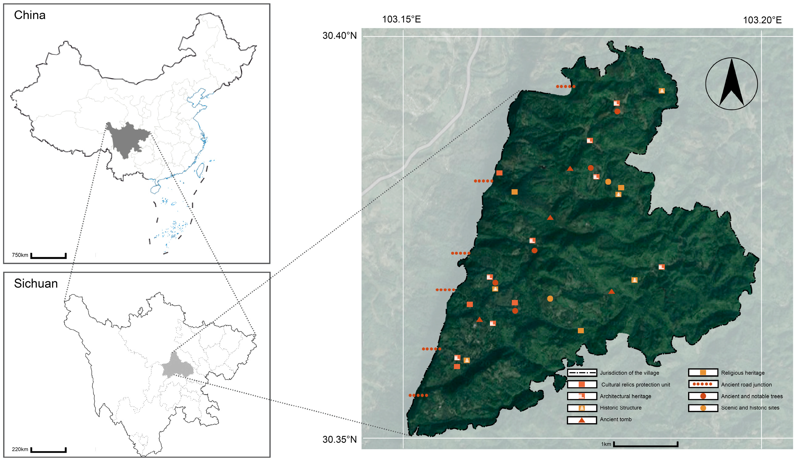
Figure 1. Location of the study area.
Sustainability 17 08981 g001
Figure 2. The current layout of Huaqiu Village: (a) settlement layout; (b) setting; (c) traditional tea plantation; (d) traditional buildings; (e) spatial structure.
Sustainability 17 08981 g002
Figure 3. NDVI of Huaqiu village (2000–2023). Calculated using near-infrared and red-light bands: the higher the value, the lusher the vegetation (ranging from 0 to 1, positive values). Negative values or low values indicate non-vegetation (e.g., buildings, bare land). Red: <0.5 (low vegetation coverage, e.g., buildings, bare land, sparse vegetation); Yellow: 0.5–0.6 (medium vegetation coverage, e.g., farmland, open woodland); Green: 0.6–0.7 (relatively high vegetation coverage, e.g., forest land, orchards); Light blue: 0.7–0.8 (lush vegetation, e.g., dense forests, highly covered grasslands); Blue: >0.8 (extremely lush vegetation, e.g., primeval forests, highly covered wetland vegetation).
Sustainability 17 08981 g003
Figure 4. NDWI of Huaqiu village (2000–2023). Calculated using green light and near-infrared bands: the higher the value (closer to 0 or positive), the more significant the water body; large absolute values of negative values indicate non-water bodies (vegetation, buildings). Red: <−0.65 (non-water bodies, e.g., vegetation and buildings, with extremely insignificant water body characteristics); Yellow: −0.65 to −0.6 (insignificant water body characteristics, dry ground or sparse vegetation); Green: −0.6 to −0.55 (relatively insignificant water body characteristics, small areas of moist ground); Light blue: −0.55 to −0.45 (significant water body characteristics, e.g., streams and ponds); Blue: >−0.45 (relatively significant water body characteristics, e.g., lakes and high-humidity areas).
Sustainability 17 08981 g004
Figure 5. NDBI of Huaqiu village (2000–2023). Calculated using shortwave infrared and near-infrared bands: the lower the value (the larger the absolute value of the negative number), the better the vegetation coverage; the higher the value (closer to 0 or positive), the denser the buildings/impervious surfaces. Red: <−0.3 (high vegetation coverage, e.g., forests and green spaces); Yellow: −0.3 to −0.25 (vegetation-dominated areas with minor building influences); Light green: −0.25 to −0.2 (vegetation–building transition zones); Green: −0.2 to −0.15 (increasing building influences, urban–rural fringe areas); Light Blue: −0.15 to −0.1 (densely built-up areas, impervious surfaces); Blue: >−0.1 (high building density, bare land, roads, etc.).
Sustainability 17 08981 g005
Figure 6. Li Family Compound: (a) the front courtyard; (b,c) the rear courtyard; (d) the ancestral hall.
Sustainability 17 08981 g006
Figure 7. The intangible cultural heritage experience of Huaqiu Village: (a) bamboo weaving; (b) tea roasting.
Sustainability 17 08981 g007
Figure 8. Landscape aesthetic of Huaqiu Village: (a) waterscape; (b) bamboo forest path; (c) traditional farmland; (d) ancient trees.
Sustainability 17 08981 g008
Figure 9. Traditional buildings and living habits in the village.
Sustainability 17 08981 g009
Figure 10. Community activities in the village: (a) poetry festival; (b) ancestor worship; (c) traditional dance; (d) tea art performance.
Sustainability 17 08981 g010
Table 1. The data details of remote sensing.
Acquisition DateSatellite/EquipmentSensor ModelSpatial Resolution
2000-04Landsat 7Enhanced Thematic Mapper (ETM+)30 m
2013-04Landsat 8Thermal Infrared Sensor (TIRS)Same as above
2023-04Landsat 8Same as aboveSame as above
Table 2. Heritage functional changes in Huaqiu Village.
No.PlaceOriginal FunctionCurrent Function
1Xu Family Compoundresidenceculture, residence
2Li Family Compoundresidencecommerce, culture, residence
3Tea Gardenplantingculture, commerce, planting
4Cliff Carving of Sanyi Templesacrificeculture, sacrifice
5Papermaking Workshop Ruinsproductionculture, education
Disclaimer/Publisher’s Note: The statements, opinions and data contained in all publications are solely those of the individual author(s) and contributor(s) and not of MDPI and/or the editor(s). MDPI and/or the editor(s) disclaim responsibility for any injury to people or property resulting from any ideas, methods, instructions or products referred to in the content.