1. Introduction
China’s rich cultural heritage spans 5000 years, with a long history of traditional historical districts embodying the most authentic Chinese cultural genes. However, globalization has recently profoundly affected Chinese cities. Although it has accelerated urbanization and fueled rapid economic development, it has also resulted in a homogenized urban landscape [
1]. Currently, conventional incremental planning is insufficient to meet social development demands, leading urban planning to evolve from large-scale projects to a focus on smaller localized spaces. Historical district renewal and protection must prioritize human needs, striving to protect both the residents and the unique cultural characteristics of these old cities. Despite the pressing issues facing urban cultural heritage, the in-depth exploration of distinctive public spaces within historical districts is lacking.
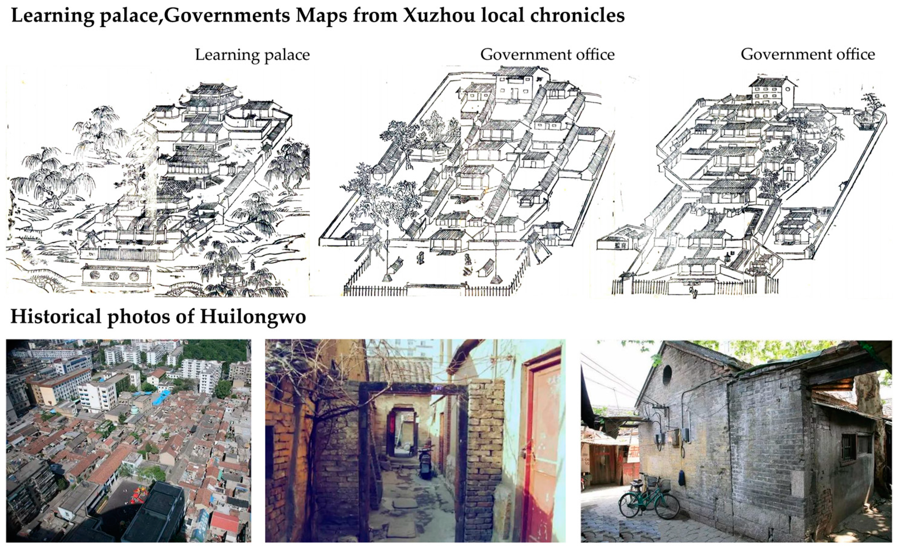
This study investigates the spatial genes of streets and alleys influenced by microtopography, which plays a crucial role in historical districts, reflecting their architectural styles and humanistic characteristics. During the Song dynasty, the traditional residential area system disintegrated, resulting in the formation of streets and alleys. The disappearance of walls transformed the city’s residential and commercial structures from isolated areas to interconnected networks of streets, alleys, and residential spaces [
2]. Streets and alleys encompass various public routes, including trails and access points, serving as transportation corridors and spaces for leisure and social interaction. The spatial genes of streets and alleys are conveyed through patterns of street skeletons, orientations, interface scales, styles, colors, rhythmic sequences, and skylines. Influenced by microtopography, these spatial genes differ from those in traditional alleys, revealing potential relationships with the surrounding terrain.
Current research on historical district streets and alleys emphasizes their historical and humanistic features, often neglecting the impact of topographical change. Therefore, in-depth research into the spatial genes of urban historical streets and alleys in relation to the terrain through qualitative methods grounded in spatial gene theory is essential to preserve these historical environments’ unique characteristics.
2. Literature Review
This study primarily explores the fields of spatial genes, historical streets, and alleys. The concept of “genes” was first introduced by geneticist Wilhelm Johannsen, originating from biology [
3]. Afterward, the American scholars Alfred Kroeber and Clyde Clarkson expanded this idea to include cultural genes. Dawkins introduced the concept of memes, which refers to the copying factor of cultural transmission in human societies [
4]. Conzen applied the notion of landscape genes to analyze historical landscapes and spatial layouts in towns and cities [
5]. Taylor used genetic analysis to characterize spatial genes in villages, extracting their core elements [
6].
Research based on related concepts has been enriched in recent years. Network analysis was employed to trace meme trends within modern architectural discourse over time [
7]. Typological methods were applied to historical heritage conservation, with historical quadrangle dwellings used as case studies to explore the geometric and natural characteristics of courtyards in Isfahan [
8]. Jin, T et al. revealed regional aggregation, penetration, and concurrency structures and summarized commonalities among different types of architecture in cultural transition zones [
9]. Additionally, Xu, H et al. filtered 71 descriptive indices of landscape genes from multiple scales by analyzing published research and statistically comparing traditional village landscape element characteristics and compositional patterns to enhance the identification and belonging of local communities [
10] and established the relationship between genetic identification and the perception of historical districts [
11]. A questionnaire survey was used to quantitatively construct an information chain for cultural landscape genes in fishing villages [
12].
As research progresses, the application of “genes” to the preservation of historical and cultural heritage has become increasingly common. Regarding streets and alleys, Lynch categorized urban elements into roads, boundaries, areas, and nodes [
13]. Afterward, the relationship between street corners and community identity was explored by analyzing urban street corner spatial elements, and these corners were posited as symbolic [
14]. The physical characteristics of streets were identified and evaluated for enhancing livability [
15], and Kim, B et al. examined the effects of street angle and width on pedestrian movement, finding that some structural and environmental factors associated with diagonal streets affected the pedestrian path choice [
16].
Recently, digital technologies have been widely used in the study of streets and alleys. Canonical correlation and multiple regression tools were used to identify a correlation between tourism density and the spatial elements of streets [
17]. A multiple regression analysis was used to assess the characteristics of users’ spontaneous improvements in microspaces between streets and dwellings [
18]. Points of interest, street-view images, and Baidu heat maps were used to build a quantitative framework for measuring street vitality [
19]. Street-view images, deep learning, and space syntax have been used to evaluate and compare street quality perception and accessibility [
20,
21]. In addition, crowd perception was integrated with the study of streets and alleys. Indices such as pedestrian satisfaction were considered to evaluate spatial vitality [
22]. The environmental impact of pedestrian-friendly, sustainable, and healthy street spaces on street walking activities was measured [
23].
Duan Jin first proposed the concept of spatial genes, conducting continuous research for more than 20 years in nearly 100 Chinese cities and defining the unique and relatively stable spatial patterns formed in the interaction among urban space, the natural environment, and historical culture as “spatial genes” in 2019 [
24]. Furthermore, as early as the late 1980s and the early 1990s, scholars such as Liu Changlin and Wang Dong proposed the concept of cultural genes in traditional Chinese culture, and in 2007, Wang Ying and Zhang Jianhui improved the appearance of traditional settlements by refining the prototypes of local dwellings [
25]. Researchers have subsequently applied these theories to the perception of cultural space in ancient towns, the development of historical urban spatial patterns, and the spatial evolution of traditional dwellings. Recently, research has established a link between quantitative spatial gene data and population perceptions [
26]. As technology has developed, scholars have conducted the spatial gene identification of traditional villages based on geographic information system (GIS) technology [
27], building a spatial database of traditional village cultural landscapes and displaying them through map visualization [
28]. As the theory has matured, scholars have constructed a quantitative spatial description system for small towns based on the perspective of genes [
29]. Spatial gene theory has matured substantially and has been successfully applied to preserve historical districts. It has also gained international research results in traditional villages [
30], urban settings [
31], and historical districts [
32].
In conclusion, spatial gene theory is mainly applied to macro- and meso-level urban design, historical district protection, and the identification of spatial genes in villages and towns, in combination with digital technology. However, few studies focus on the micro level, overlooking topography’s impact on a city’s historical districts. Most of the spatial genes of historical districts are analyzed in terms of block space, street space, and architectural space, etc., but they are always discussed separately. In fact, the boundaries of these spaces are vague, and the path of human experience in historical districts is mostly dominated by the micro level, and a macro analysis cannot really explore the real connotation of the street space. It is important to pay attention to the micro-level expression of the spatial genes of street space.
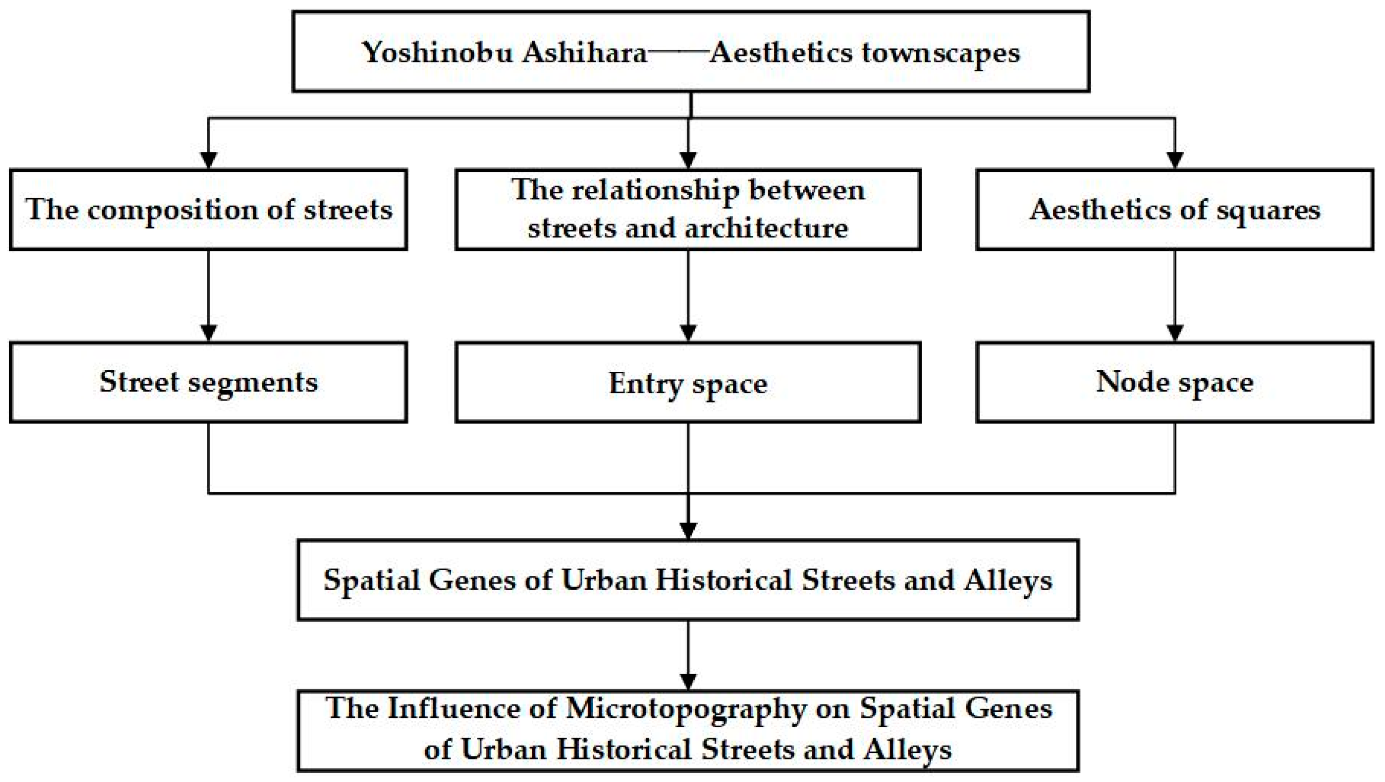
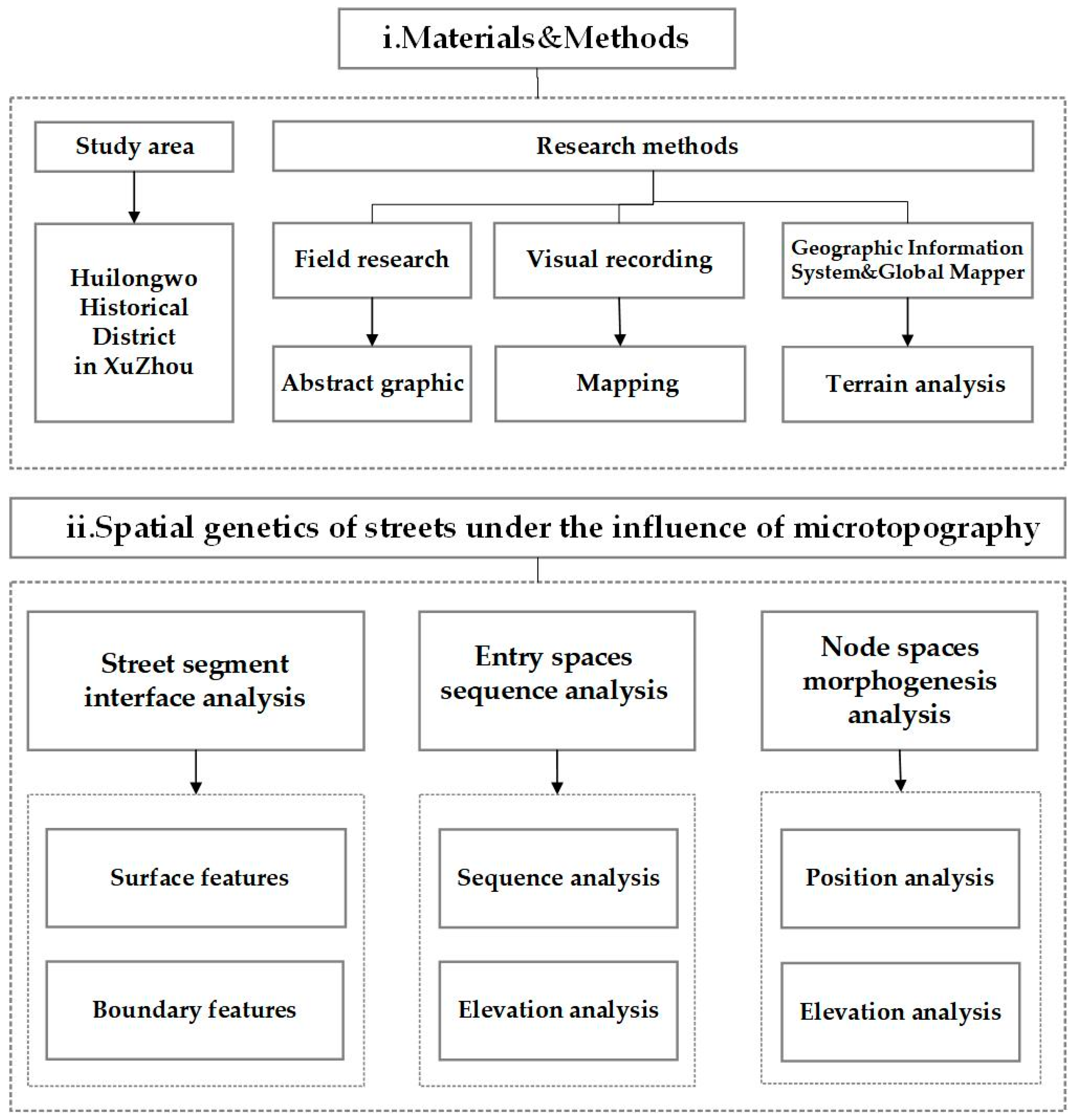
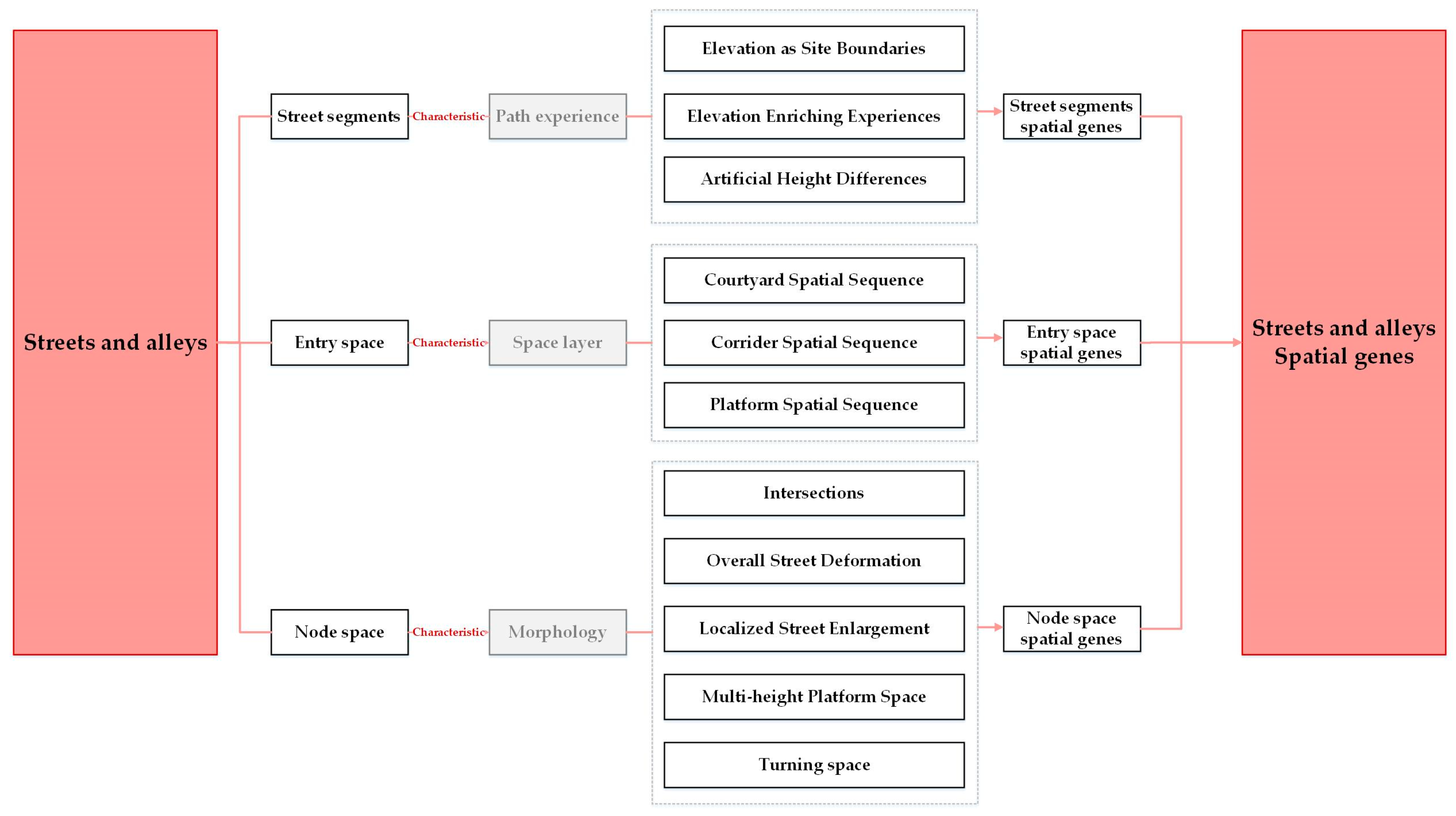
Yoshinobu Ashihara analyzed the design points for street space from the perspectives of the relationship between streets and architecture, the composition of streets, the width-to-height ratio of streets, and the aesthetics of squares. It can be seen that street space genes need to be discussed from multiple perspectives, which is an important theoretical basis for this paper. Most of the research focuses on street segments, i.e., the “skeleton” of street space. However, if only the street segment is studied, the relationship between the street and the architecture will be separated, providing an incomplete explanation of the spatial beauty of the street. Therefore, this study discusses street composition, the relationship between streets and architecture, and the aesthetics of squares from the street segment, entry space, and node space perspectives, respectively (
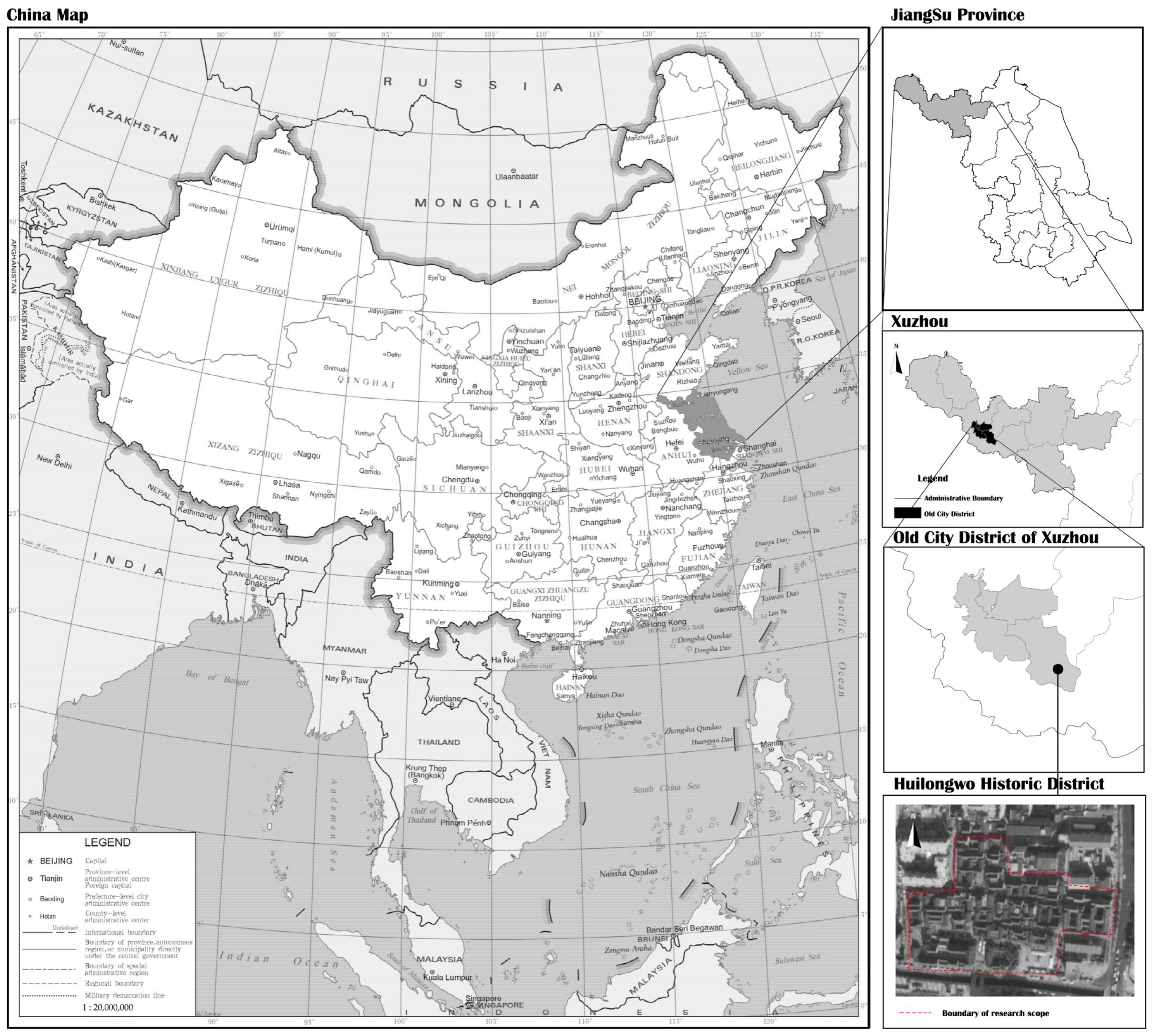
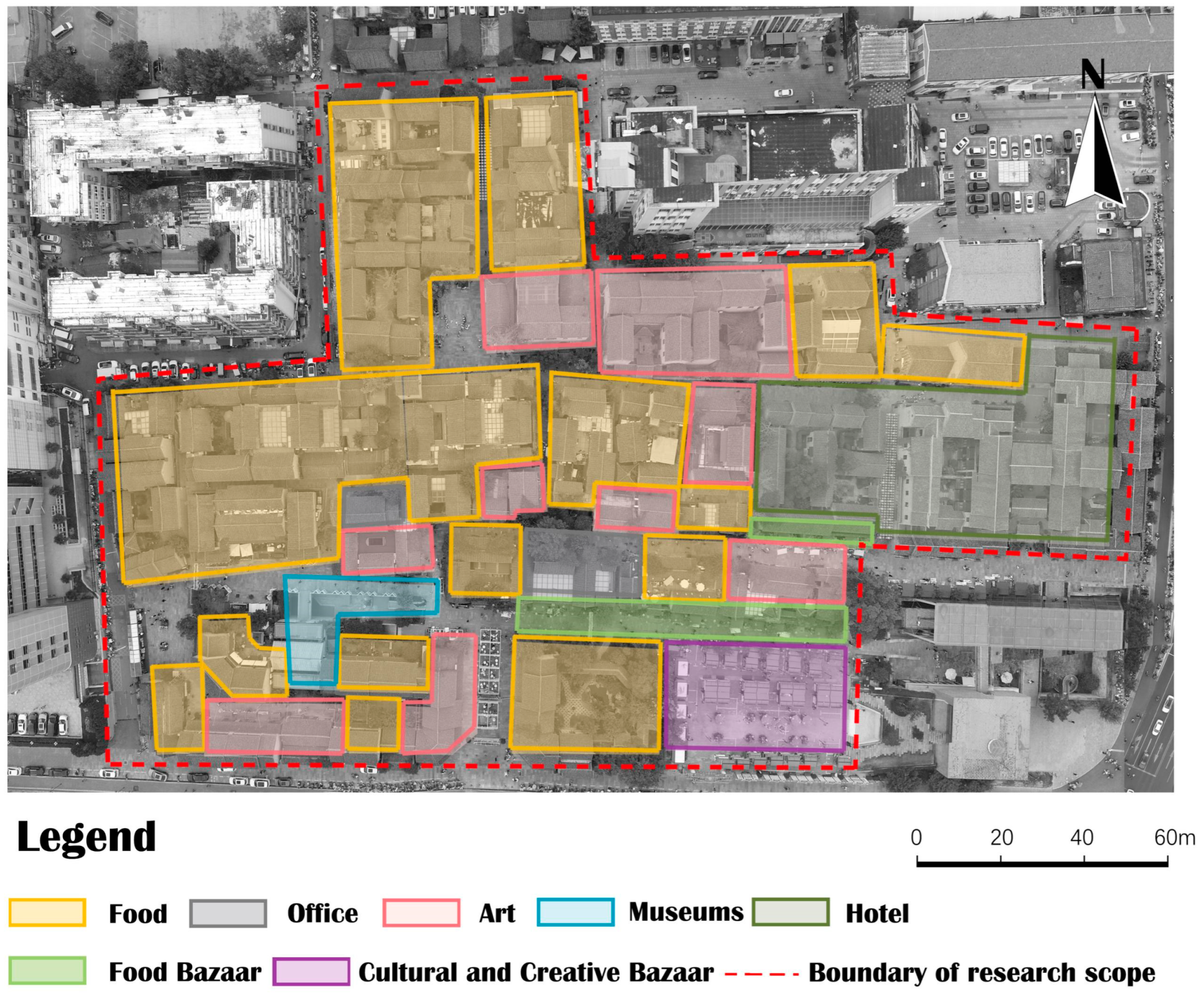
Figure 1). Taking the ancient town of Xuzhou City as the study area and Huilongwo historical district as the research object, and considering Xuzhou’s mountainous topography and Huilongwo’s sloping terrain, this study applies qualitative research methods to comprehensively analyze the multiple spatial genes of district streets and alleys. This study enriches the research perspectives and depths of the protection of historical districts and has practical guiding significance, aiming to provide a reference for decision-making regarding the preservation and updating of the cultural heritage of Xuzhou’s historical districts.
4. Analysis
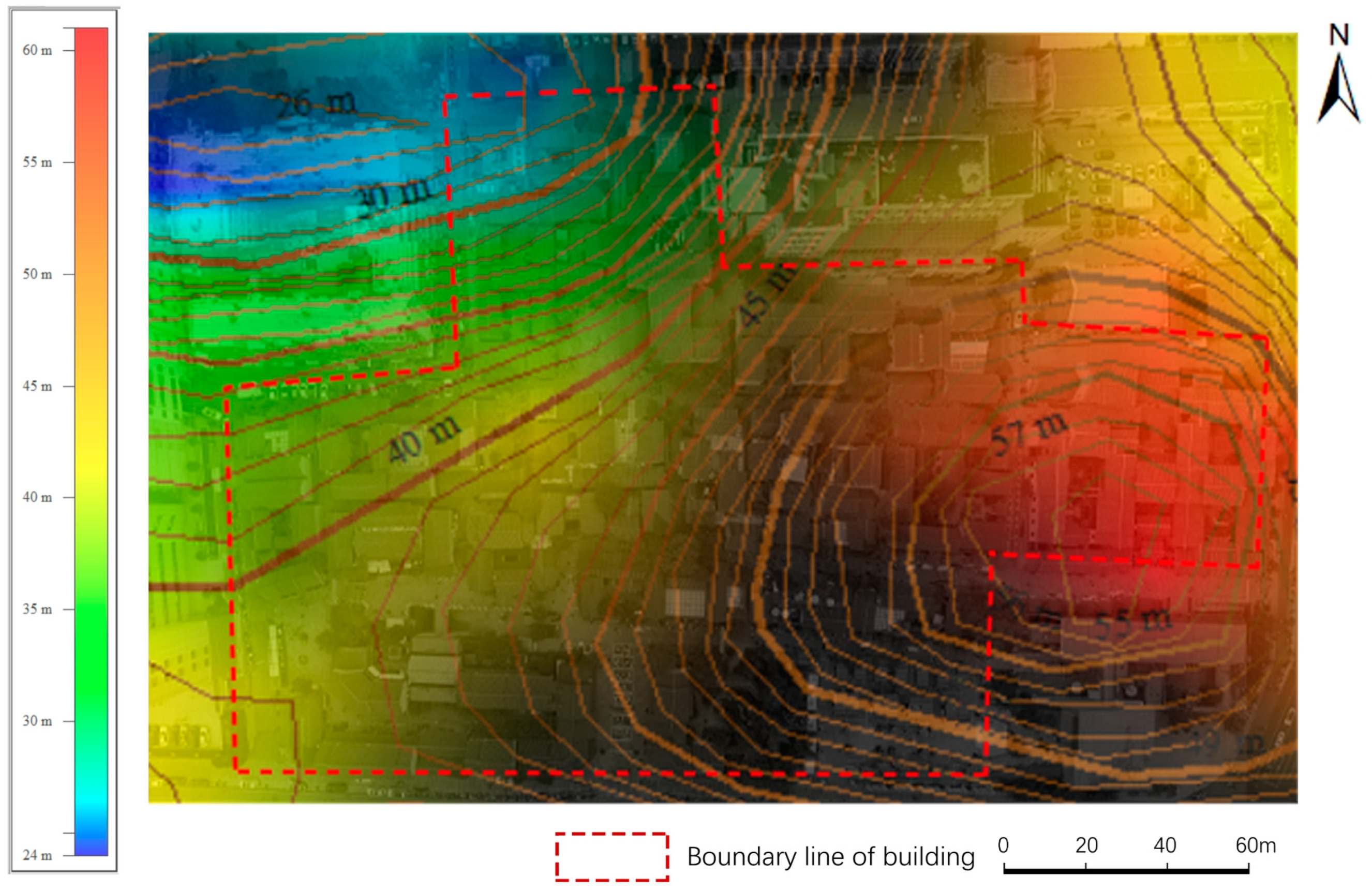
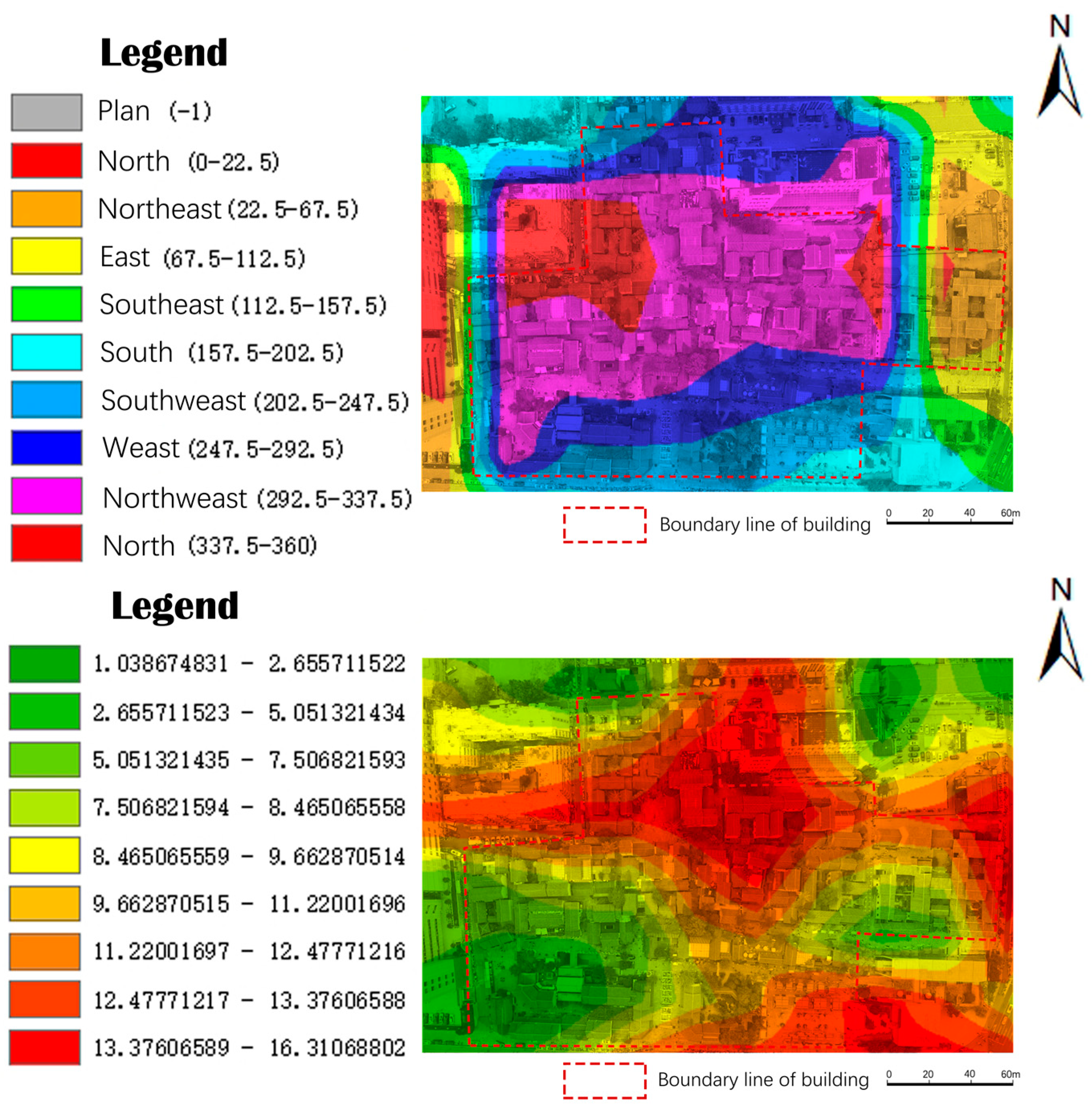
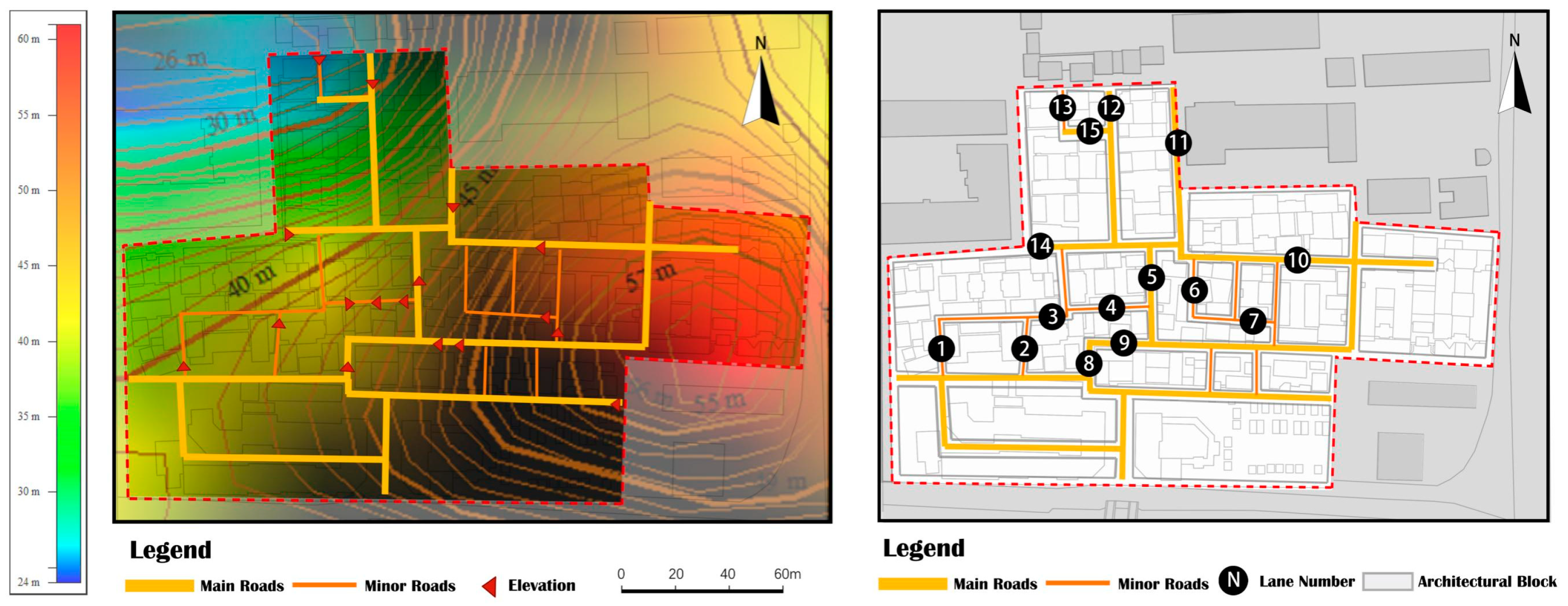
An initial microtopographic study of Huilongwo was conducted. The elevation map (
Figure 6) illustrates two height centers in the district: one in the center and the other in the east. The topography displays an increasing trend from south to north and around the two centers, with the lowest ground-level heights located on the north and south side. The slope direction and slope map (
Figure 7) show that the northward and northwestward slopes account for a larger proportion of the terrain, and the slope of the entire area does not exceed 20°; thus, the terrain is not steep or dangerous. However, there are also some slope changes. Microtopographic variation is a significant feature of Huilongwo district. The study of street and alley genes under the influence of microtopography is a unique perspective in current historical district conservation research.
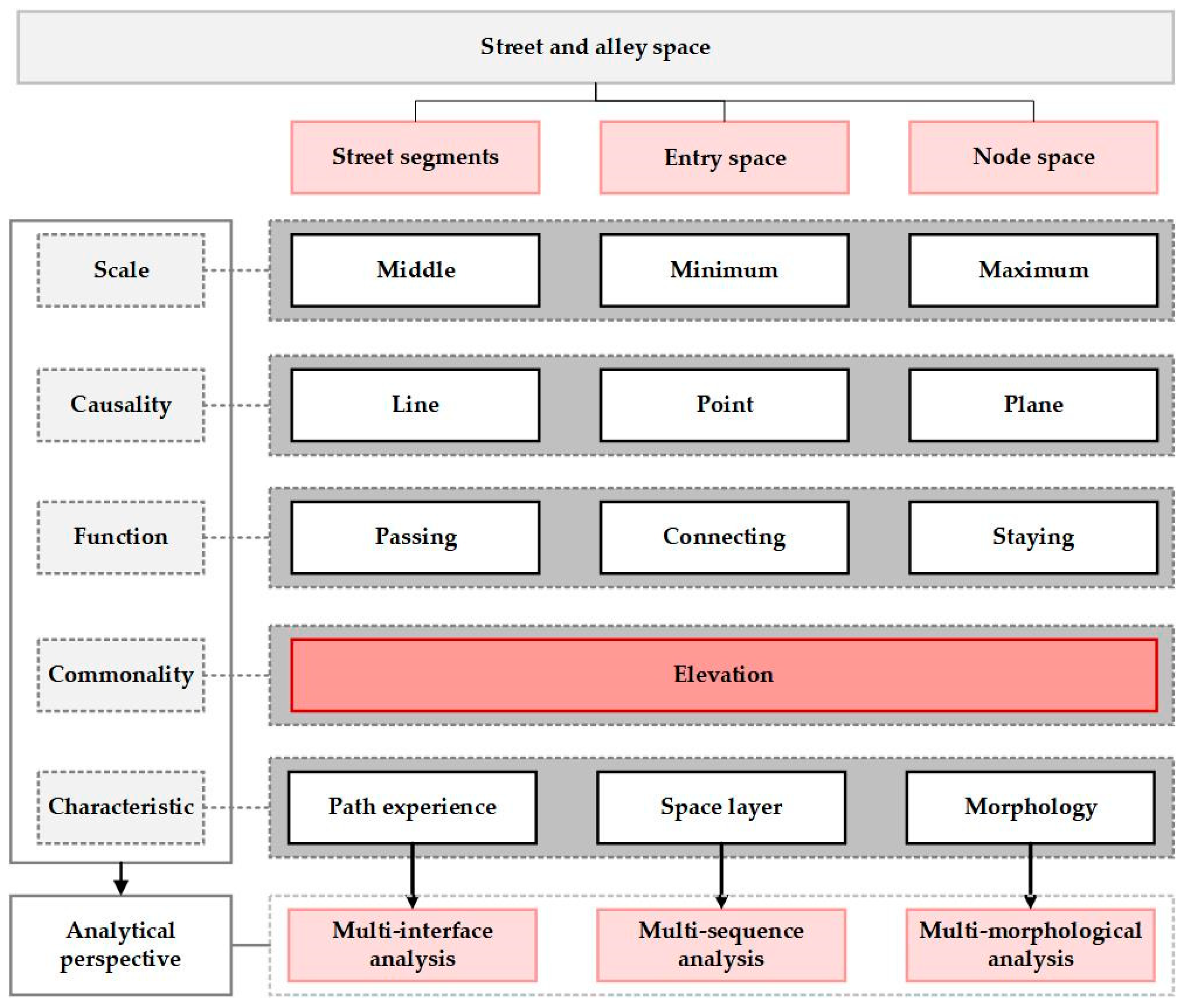
Based on the theoretical framework provided by Yoshinobu Ashihara (
Figure 1), the spatial characteristics of streets and alleys were categorized into three dimensions: street segments, entry spaces, and node spaces. First, the scale of these three categories are different; node spaces are maximum, and entry spaces are minimum. Second, their causality are line, point, and plane, respectively, which includes the basic elements of space. In terms of function, they represent passing, connecting, and staying. They also vary in their characteristics, which are path experience, space layer, and morphology. However, elevation is common to them all, and together with the microtopographic characteristics of Huilongwo district, the elevation of all three dimensions needs to be focused on to extract the spatial genes of the streets and alleys under the influence of microtopography. Based on the above, this paper adopts different perspectives to analyze these three dimensions separately, including multi-interface analysis for street segments, multi-sequence analysis for entry spaces, and multi-morphological analysis for node spaces, to ensure the completeness of the study (
Figure 8).
The characteristics of streets and alleys under the influence of microtopography can be approached from the perspective of these three dimensions through field exploration, visual recording, computer mapping, and other methods to establish an intuitive feeling and systematic cognition of the site, which helps explain its characteristics.
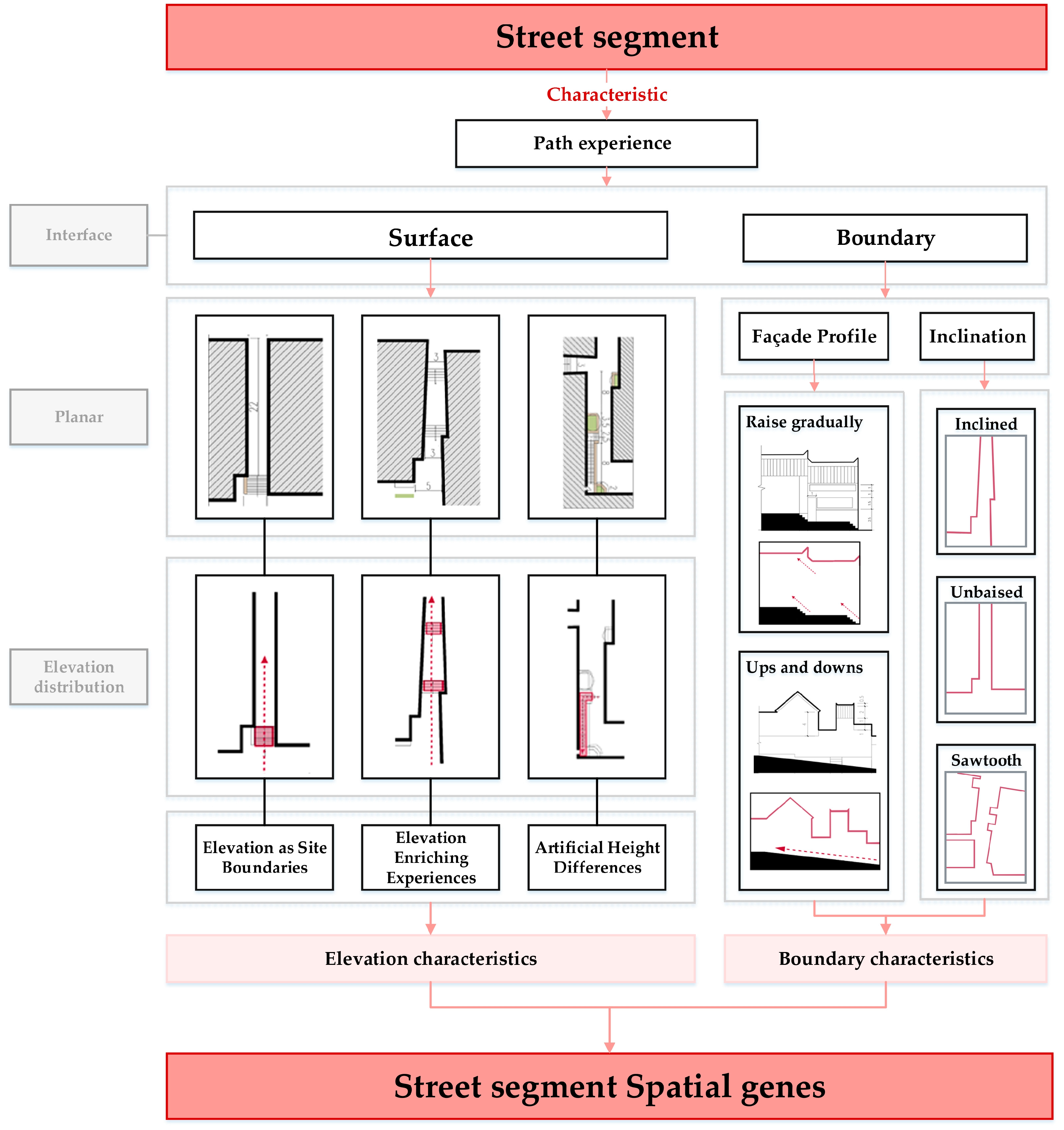
4.1. Street Segment Multi-Interface Analysis
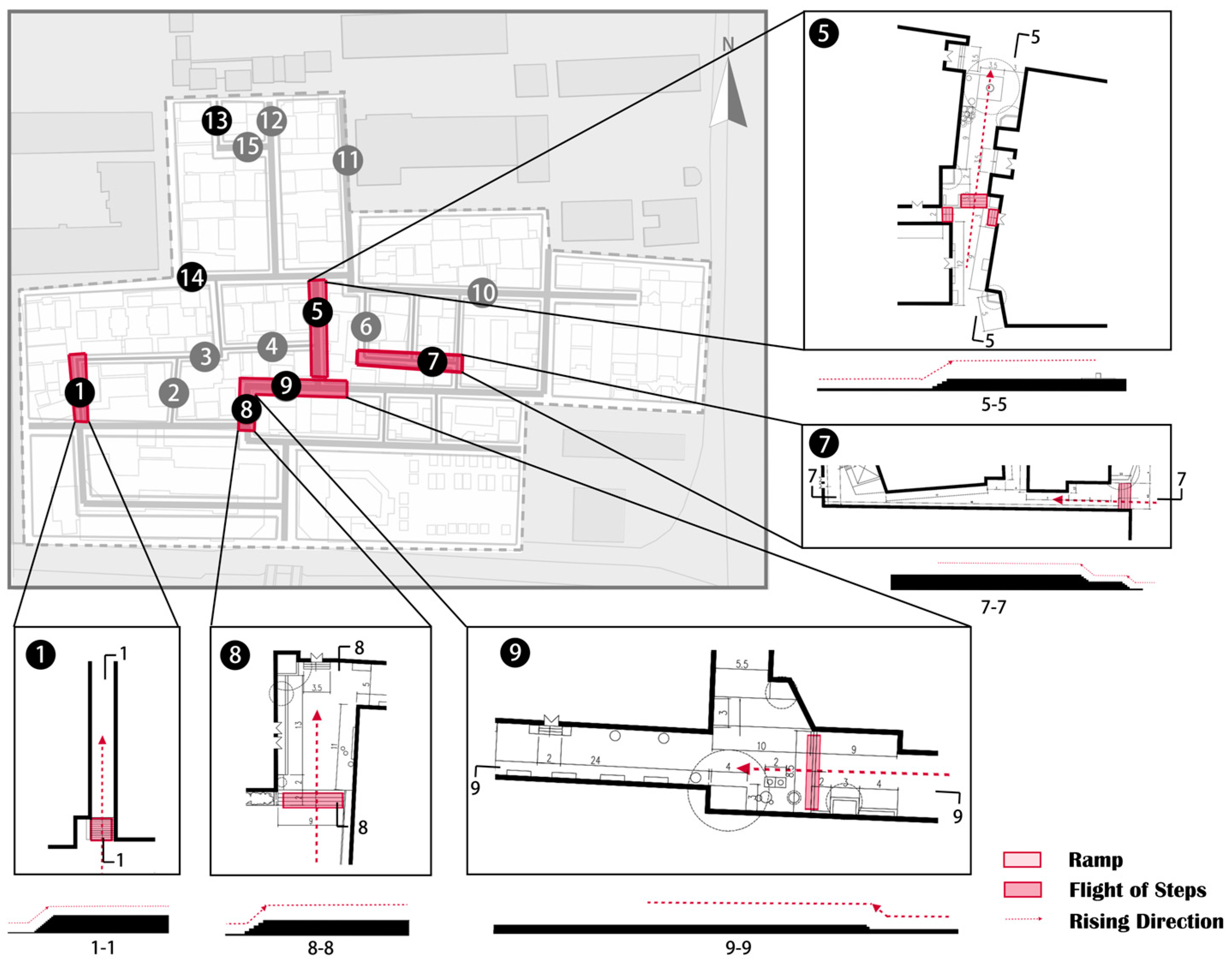
The main road in Huilongwo district extends in a branching pattern from south to north, with the many minor roads dispersed from it (
Figure 9) exhibiting three patterns: branching, radiating, and gridded. Narrow alleys increase space accessibility and push the functions of architectural groups outward and toward the public. As noted above (
Figure 6 and
Figure 7), the district height tends to increase toward the two elevation centers. The ramps and steps in the district are marked with arrows during field research. Combined with the elevation map, it can be seen that the elevation distribution and the topographic features are almost the same on the macro level (
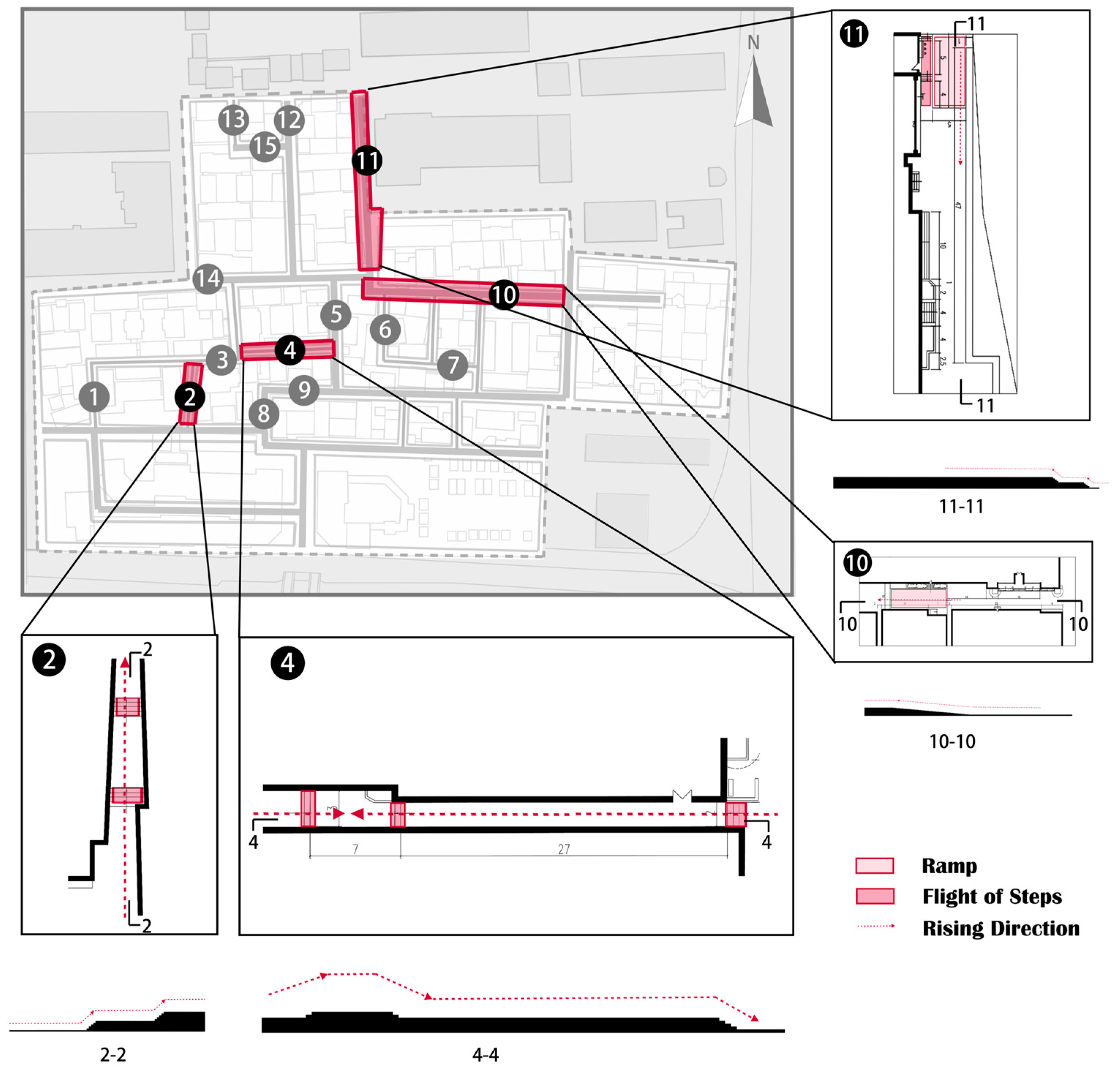
Figure 9); thus, the microtopographic features of Huilongwo district have a certain influence on the characteristics of the street space. Representative street segments (
Figure 9) were selected to summarize Huilongwo’s genetic characteristics from the surface and boundary to explain the differences.
4.1.1. Surface Features Surface
Based on the different forms of combinations with the terrain, the 15 district alleys were divided into three categories: elevation as a site boundary, elevation as an enriching experience, and artificially established height differences.
- (1)
Elevation as a Site Boundary
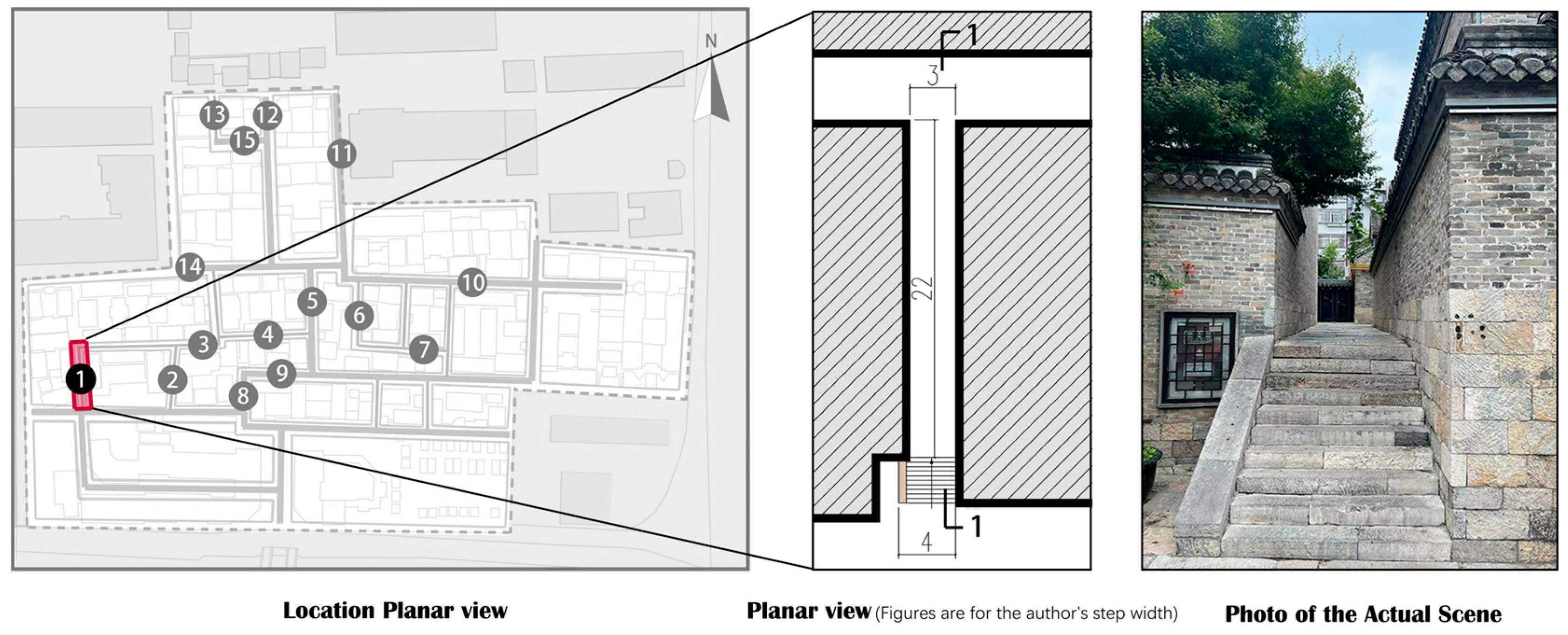
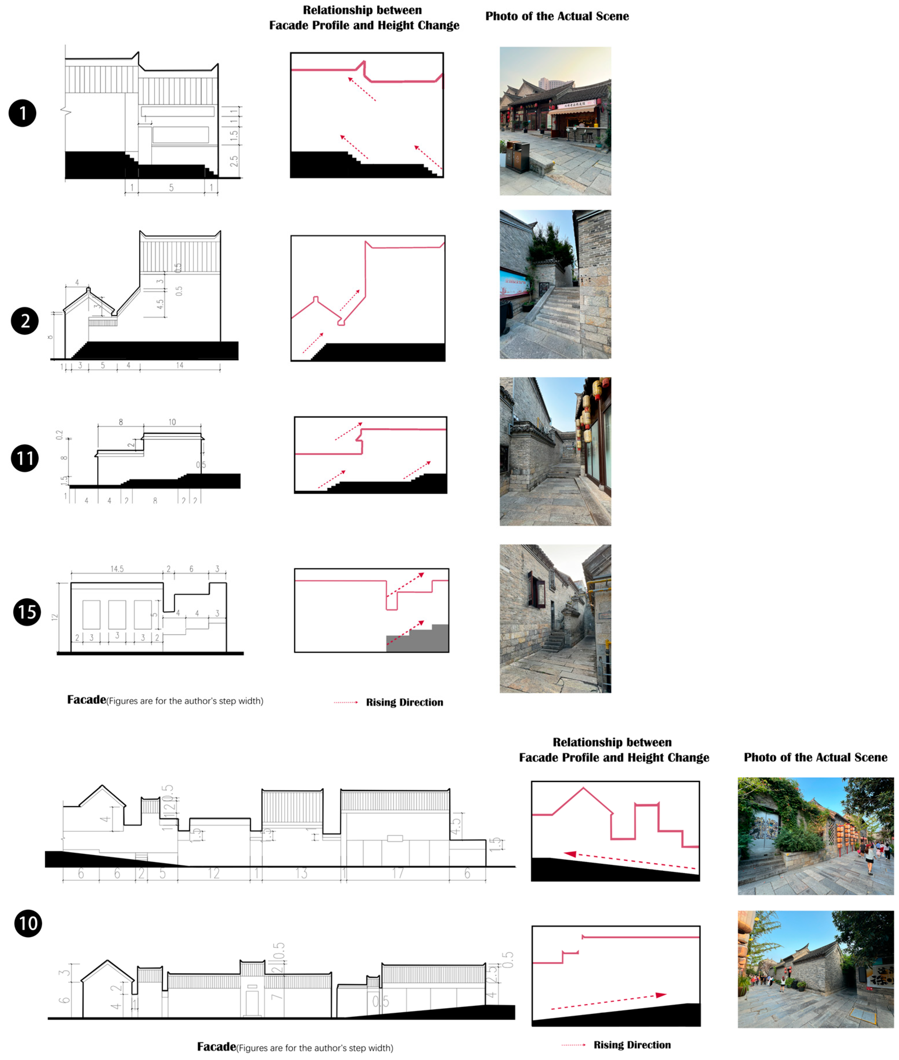
Lanes 1, 5, 7, 8, 9, 13, and 14 are situated in the district’s undulating part and establish clear spatial boundaries based on the terrain. The spatial characteristics of the two sections separated by elevation vary depending on their locations. The following section describes each street segment’s basic characteristics and analyzes how they fit their respective topographies.
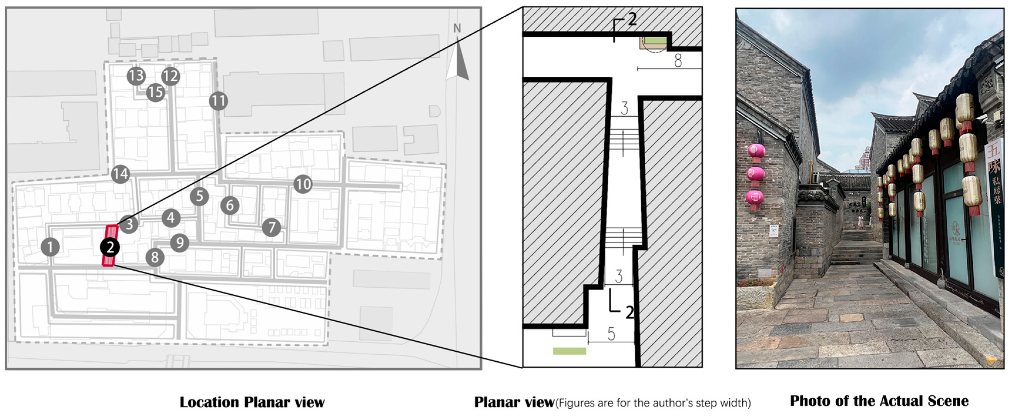
Lane 1 is located on the west of the district, and the height change is realized through steps at the entrance to differentiate between the primary and minor roads with a strong sense of spatial division (
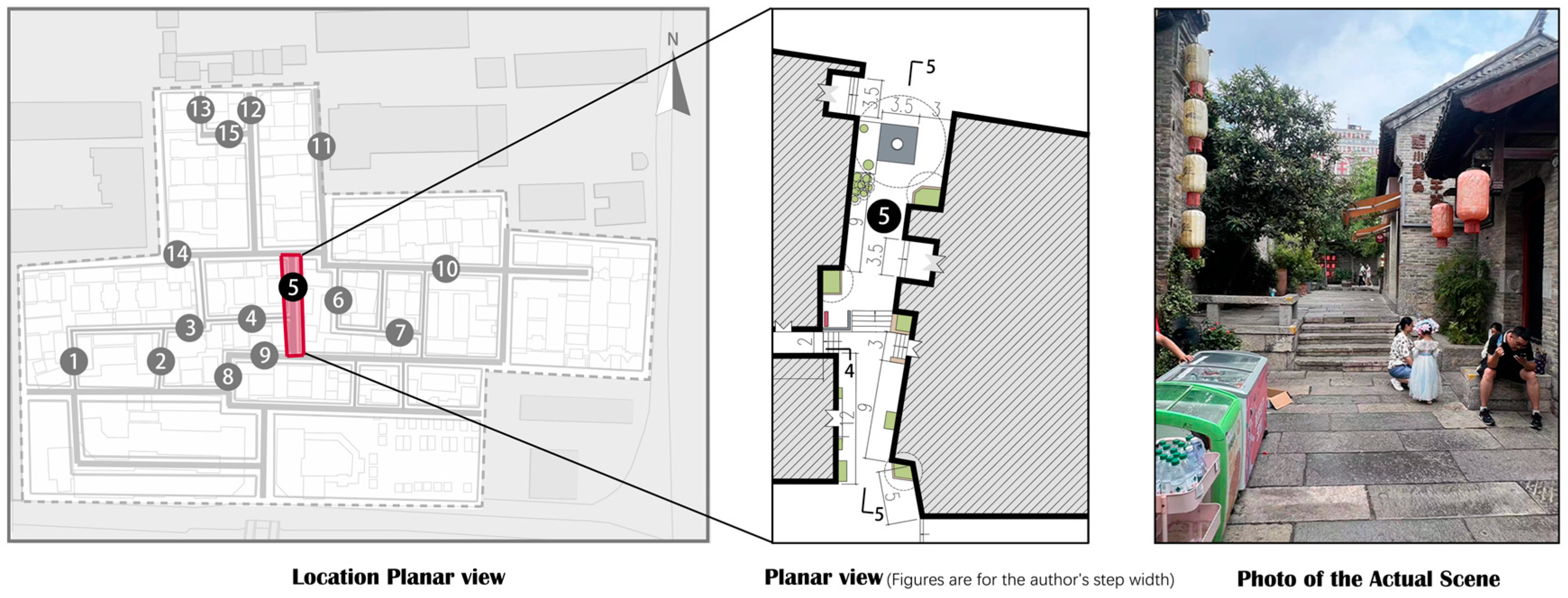
Figure 10). Lane 5 is in the center, serves the functions of passage and leisure, and forms a small spatial node in the north to gather and disperse people. The steps in the middle of the alley play a prominent separating role in line with Huilongwo district’s topographic characteristics (
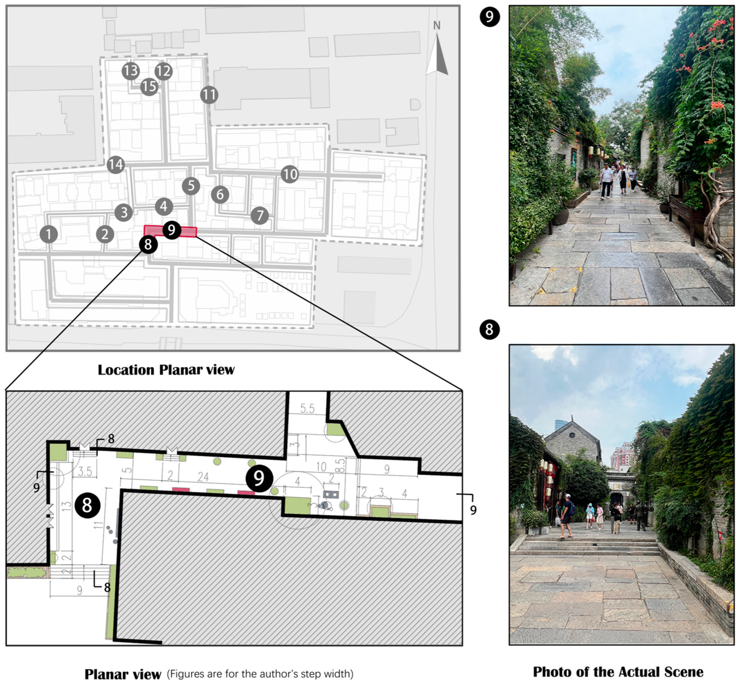
Figure 11). Lanes 8 and 9 are close to the south square, which are two lanes with a turning relationship. Both lanes elevate part of the site through steps to form a node space, and the height change complies with the microtopographic characteristics (
Figure 12). The street segments’ step location and crowd flow (
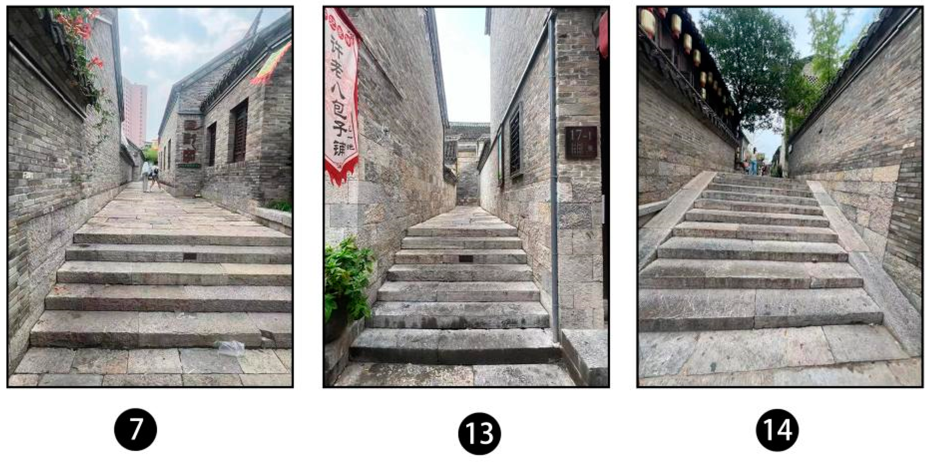
Figure 13) show that the steps form a clear spatial separation: main and minor roads, access and node spaces, and external and internal roads. Similar results are observed in lanes 7, 13, and 14 (
Figure 14).
- (2)
Elevation as an Enriching Experience
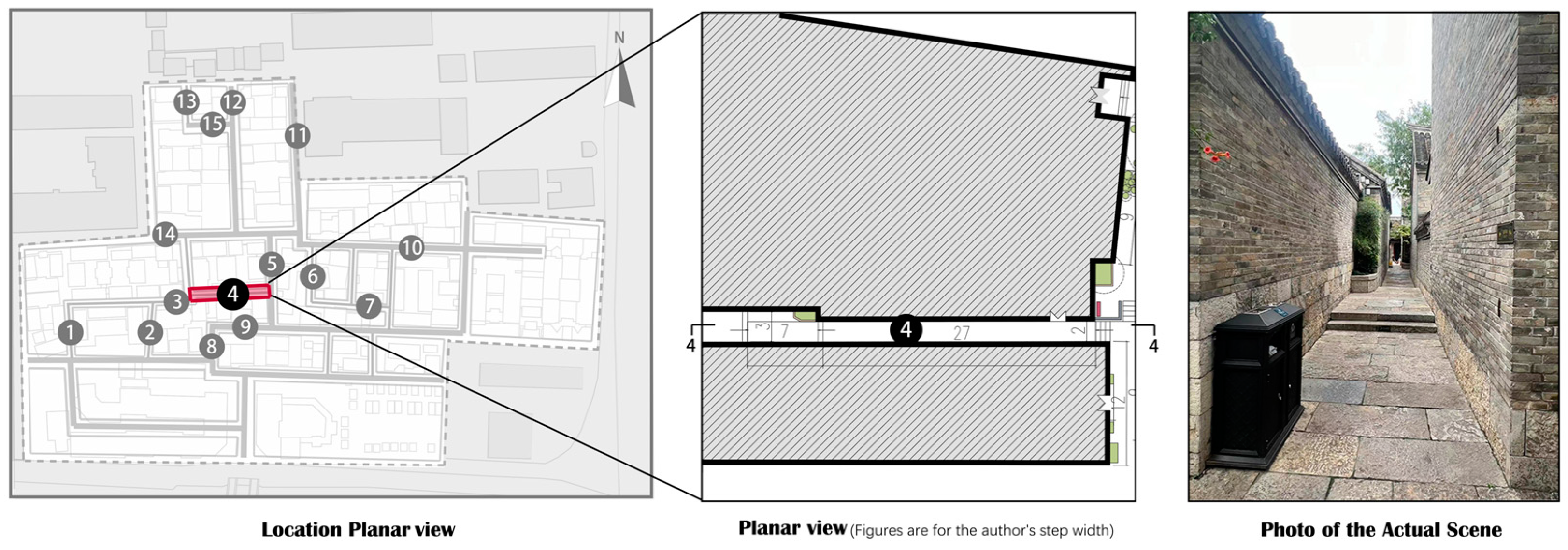
Lanes 2, 4, 10, and 11 are in the district’s undulating part and have a softer terrain, which differs from that in the previous section. Ramps or multiple steps are used to weaken height changes and enrich the human walking experience.
Lane 2 is in the western part of the district, and the terrain change is gradual. This weakens the perception of terrain change and reduces the sense of boundaries between lanes (
Figure 15). Lane 4 is in the center of the site, and its primary function is access. In the planar view, Lane 4 presents rising and falling height changes; therefore, there is no significant height change between the entrance and exit. The lane is deep, narrow, and sufficiently long to guide people quickly (
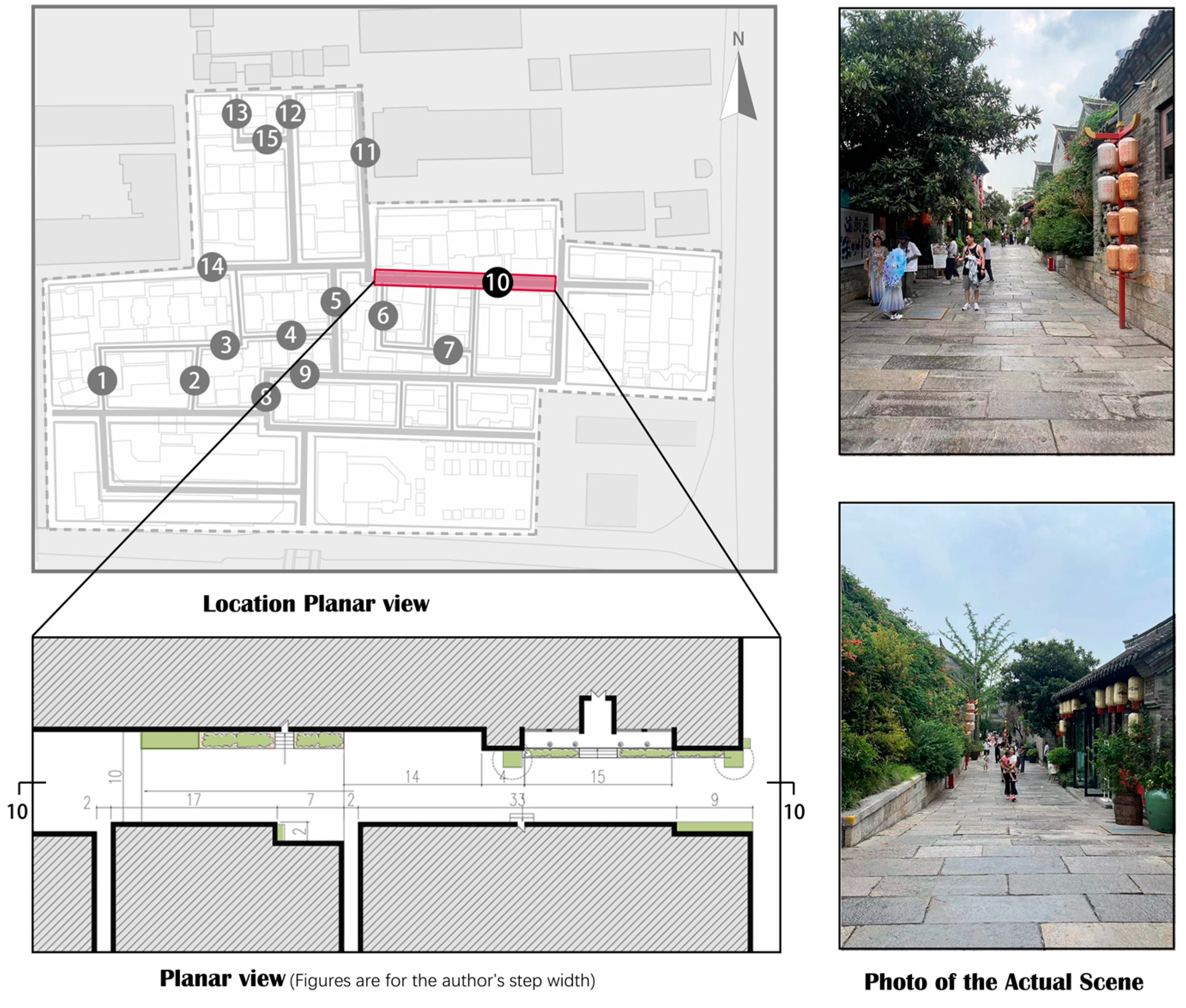
Figure 16). Lane 10 is the district’s main road and is sufficiently broad to accommodate large crowds. The street rises from east to west and handles the height difference in a gentler manner through ramps, managing the topographical difference while reducing the crowd’s perception of the height change and prolonging their traveling experience (
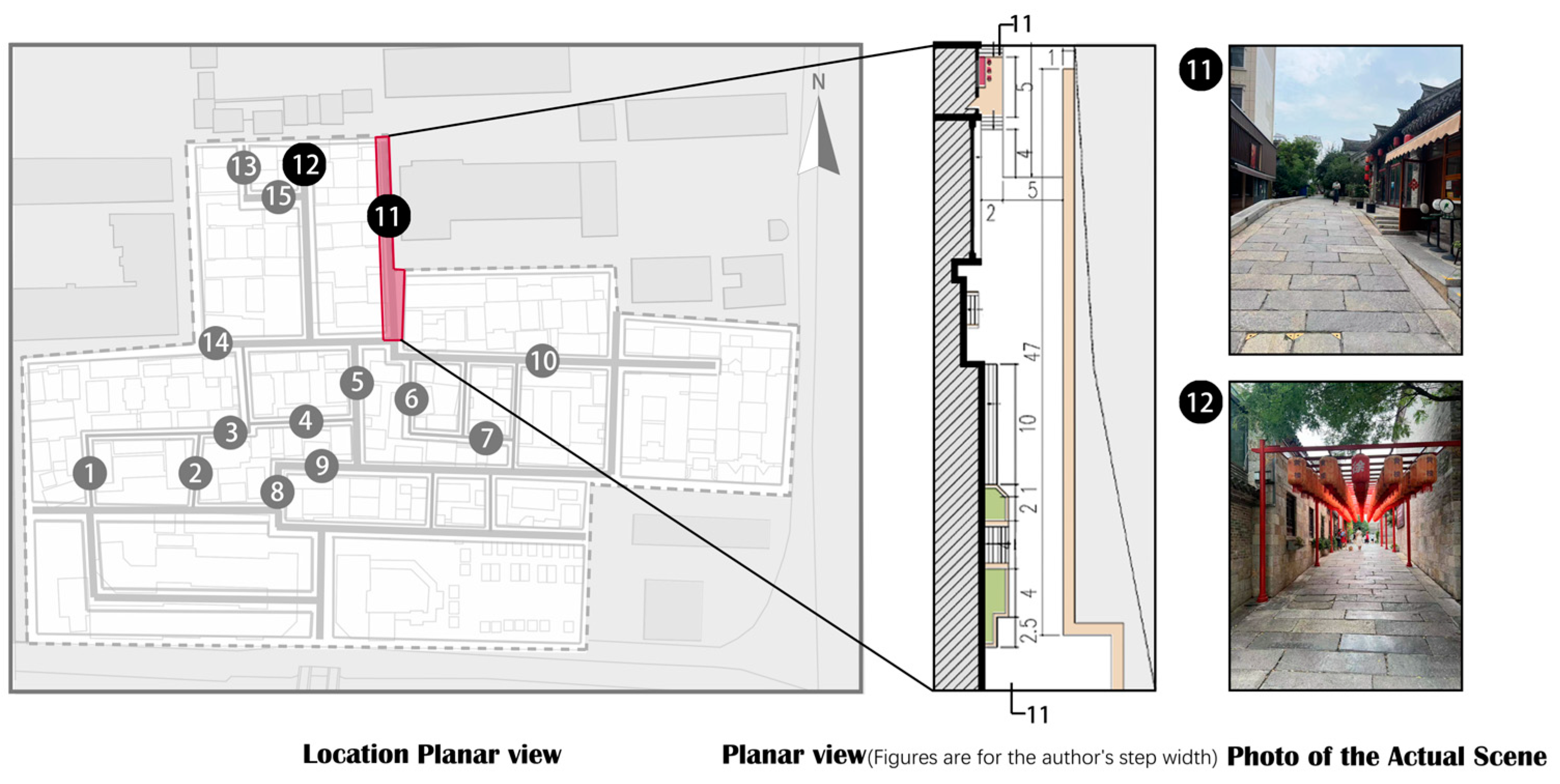
Figure 17). Lane 11 is on the northeastern boundary of the district and uses both steps and ramps, with the platform between the steps forming a space for sitting and entering a house. Lane 12, which also uses ramps, has a more unified spatial composition because of the closure of the façade on both sides (
Figure 18). An analysis of the distribution of the steps, ramps, and crowd flow in the above street segments (
Figure 19) demonstrates that the height differences are integrated into the entire path experience, and the spatial segregation relationship is not obvious. Multiple-step, long-ramp, and step-and-ramp combinations appear in different combinations.
- (3)
Artificial Height Differences
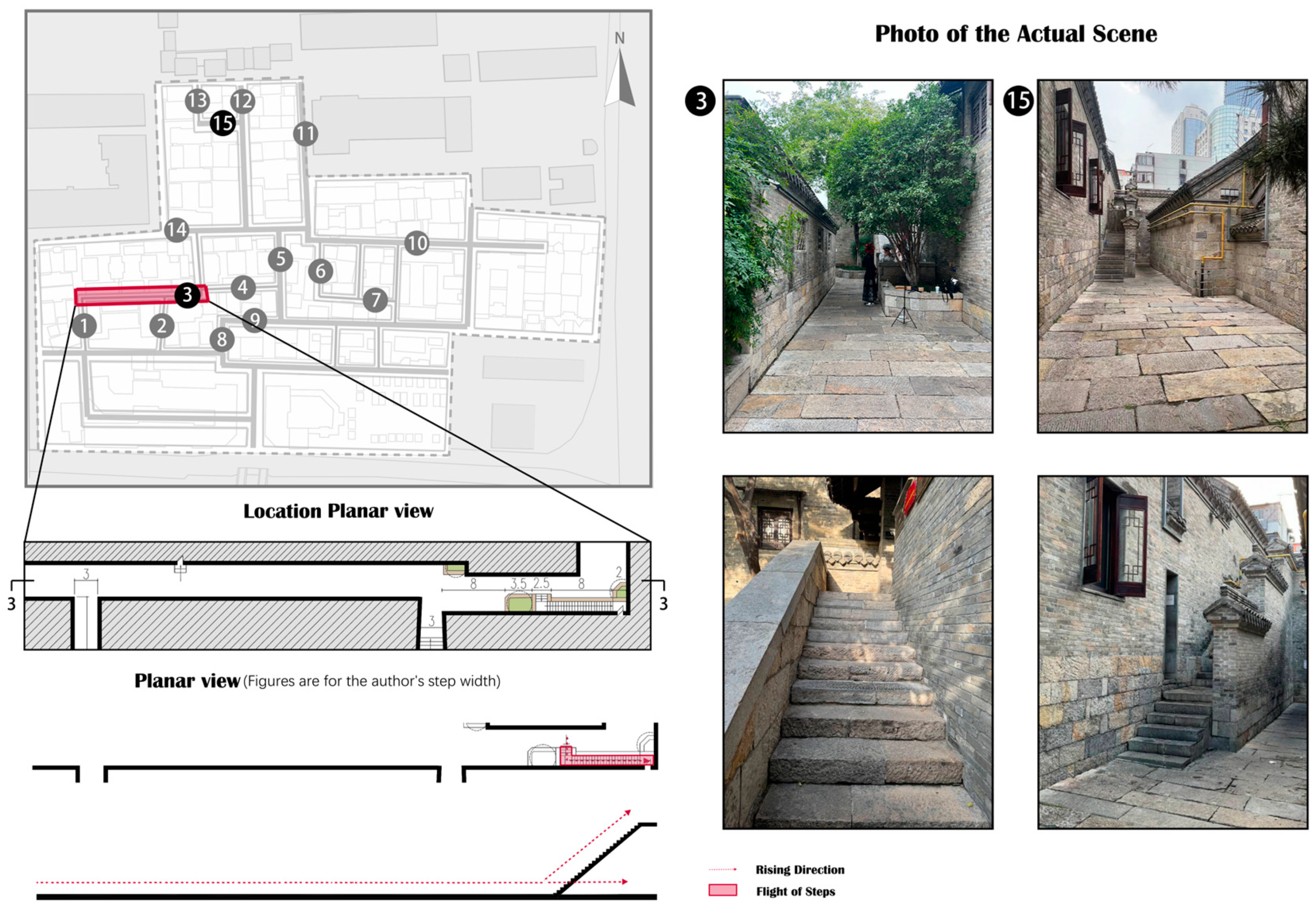
Several types of streets and alleys are based on topographic changes; additionally, some are located on flat surfaces, and artificial height differences increase the diversity of activities. For example, Lane 3 is located west of the site, and it has no height difference; however, the first-floor entrance of the architecture is connected to the ground floor by multiple entry steps, and pedestrian flow occurs in both forward and upward directions, reducing the impact of the upward flow on pedestrians’ forward flow. This was also observed in Lane 15 (
Figure 20). This situation is unrelated to the topography and is an accessory entry space in architecture.
In conclusion, the microtopography affects Huilongwo district’s streets and alleys, as reflected explicitly in each alley’s planar form. The topography combination is divided into elevation as a site boundary, elevation as an enriching experience, and artificial height differences. Three methods address height differences: steps, ramps, and a combination of steps and ramps. Steps establish the boundary between street and alley spaces and precisely indicate the entrance and direction. In comparison, ramps or multiple small steps can weaken the boundary between two alleys, diminish people’s perception of height changes, and minimize the impact on their walking experience. Some alleys additionally artificially establish a connection between the first-floor entrance and ground floor using a staircase, which serves as an accessory entry space for the architecture.
4.1.2. Boundary Features
The above elaborates on the surface features of the street segments, and the following explores their boundary features, which are influenced by elevation and architectural orientation, showing three kinds of forms—inclined, unbiased, and sawtoothed—that embody the façade.
- (1)
Façade Profile Influenced by Elevation
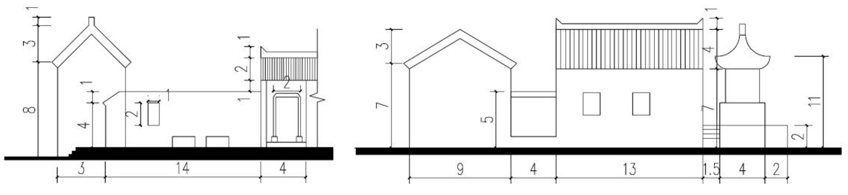
The above discussion results from several topographic treatments that are reflected in the façades and planar features. The external profile of Lane 1’s façade shows a tendency to rise with climbing steps. Lane 2 lags in the façade profile; the corresponding façade profile at the step is flat, but the profile climbs in a subsequent smooth section. Lane 10 uses ramps to reduce the impact of height differences on walking; the façade profile at the ramp is raised, and cut-offs break the façade continuity so that the combination of architectural units feels rhythmic. Lane 11 also uses ramps and steps to incorporate height differences into the entry space, and the eaves are gradually raised in response. Although there was no obvious change in Lane 15’s topography, the artificial establishment of height differences allows the first-floor entrances to be connected to the ground level and reflect the façade’s progression (
Figure 21).
- (2)
Façade Influenced by Architectural Orientations
The architectural combinations’ richness reflects the influence of multiple architectural orientations on the façades. For example, the façade of Lane 5 is reflected in the combination of the entry spaces, enriching the façade’s composition through multiple elements including doors, steps, and eaves. Lane 6 breaks the façade’s closure by incorporating a pavilion. This type of alley space is characterized by rich variation in the façade’s outer contour, often with cut-offs to break the continuity (
Figure 22).
- (3)
Boundary Inclination Influenced by Architectural Orientation
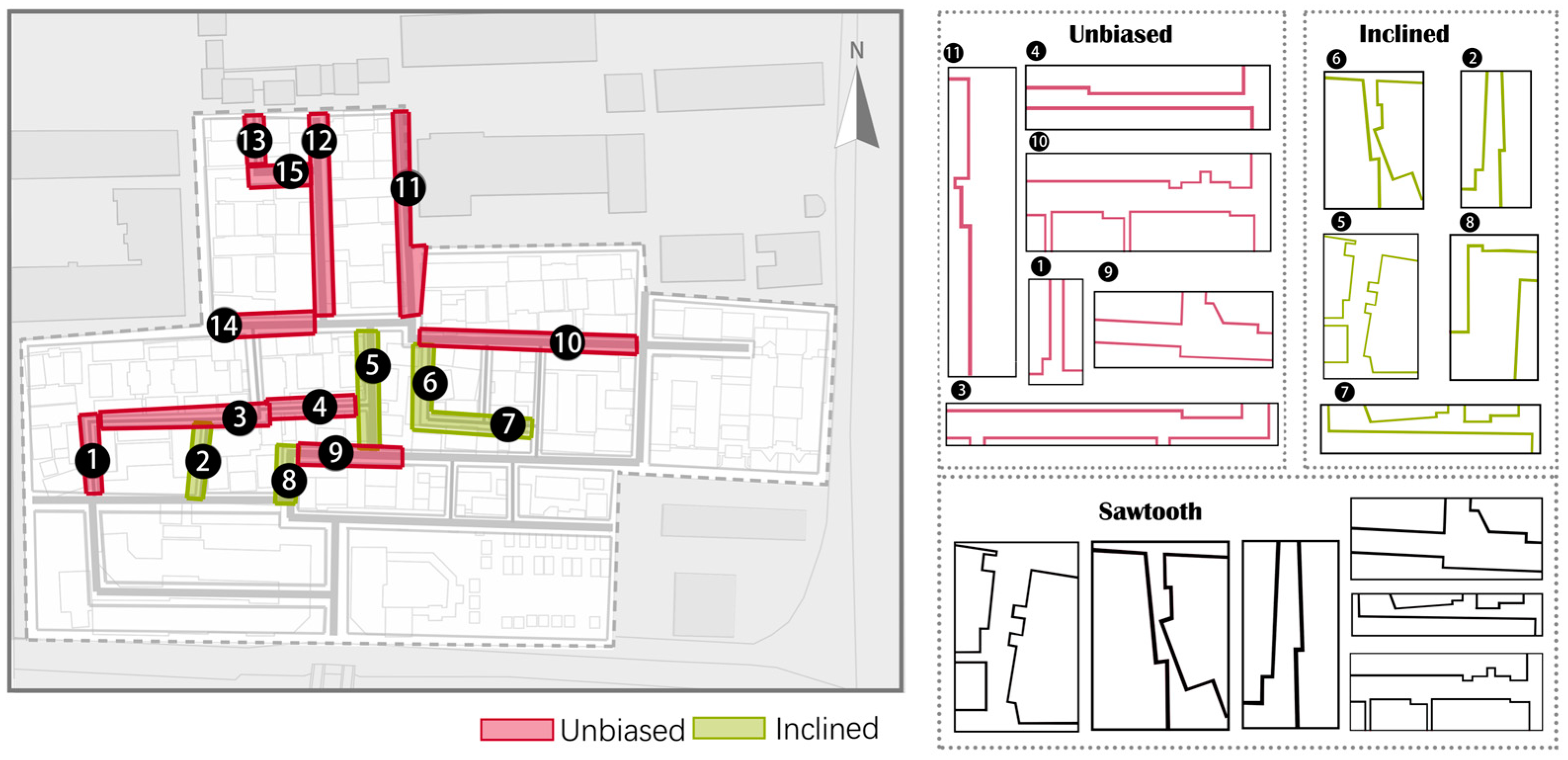
The planar morphologies of the alleys were classified into inclined, unbiased, and sawtoothed categories. Inclined and non-inclined lanes differ in whether the interfaces are non-parallel or inclined toward one side.
Figure 23 illustrates that most Huilongwo streets and alleys have no tendency, but some minor roads do. The interfaces on both sides of the lanes with no tendency were flat and directional; this is particularly apparent on the main roads. Occasionally, concave spaces are formed by the setback of the entry space or architectural displacement, but this does not affect the entire district’s spatial orientation, which is mainly reflected in Lanes 1, 3, 4, 9, 10, 11, 12, 14, and 15. The inclined lanes slope toward one side, eventually showing a wide or narrow end; this appears most often on minor roads, mainly in Lanes 2, 5, 6, 7, and 8. Sawtoothed interfaces originate from architectural setbacks or inclinations forming corners or concave spaces. The former are primarily formed by architectural entry space setbacks or architectural dislocations, whereas the latter are formed by architecture with different orientations. On inclined and non-inclined streets, the connecting architecture tends to be detached and dislocated, forming sawtoothed interfaces (
Figure 23).
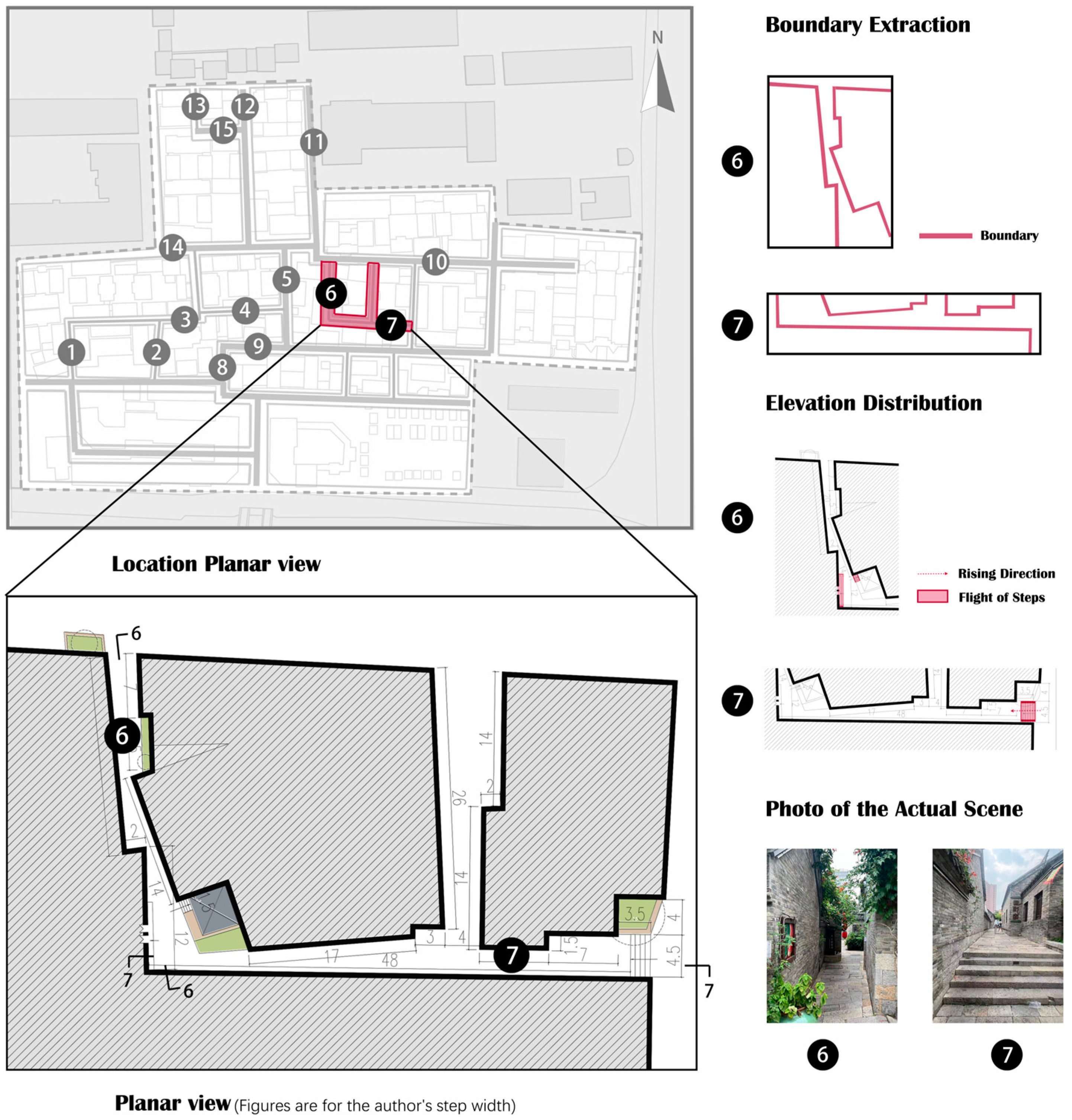
Lanes 6 and 7 were selected to analyze the spatial morphology characteristics of the inclined and sawtoothed interfaces in detail. The alley scale is small, with a pavilion at the corner to break the closure of the narrow alleys, which can weaken their sense of tightness with large height-to-width ratios and reduce the fear of unknown parts while walking. From the street interface, the architecture on both sides has an inconsistent orientation and concave–convex changes, forming an irregular zigzag planar form (
Figure 24).
In conclusion, two distinctive features characterize Huilongwo’s streets and alleys: the microtopography’s influence and the irregularity of street interfaces. The impact of the microtopography on street segment spatial genes is significant and evident in both the planar and façade characteristics. Many streets and alleys use height differences to create unique entry spaces, thereby enhancing their distinctive features. Additionally, architectural orientation is crucial in enriching the planar boundaries and façades of these streets and alleys.
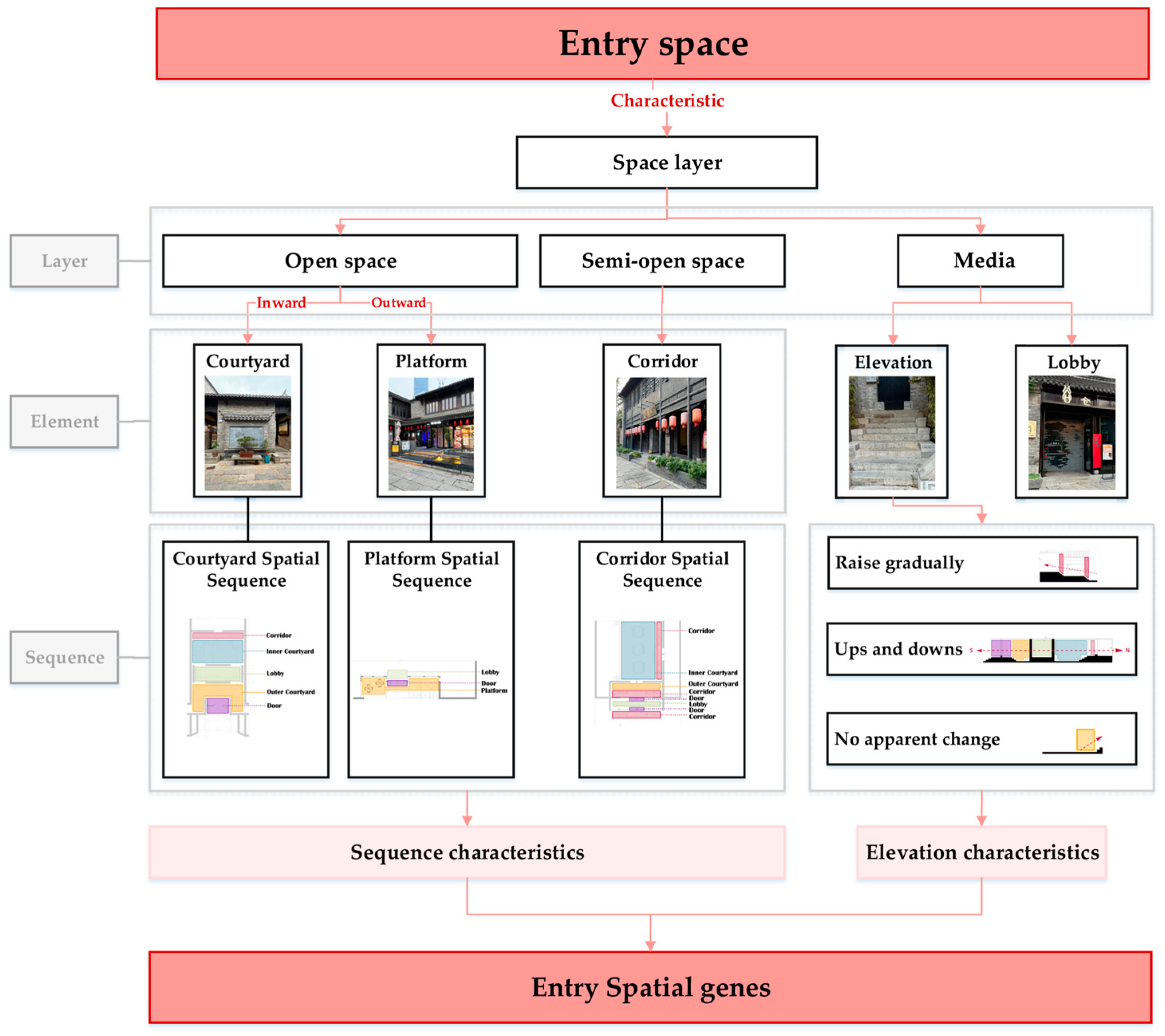
4.2. Entry Space Multi-Sequence Analysis
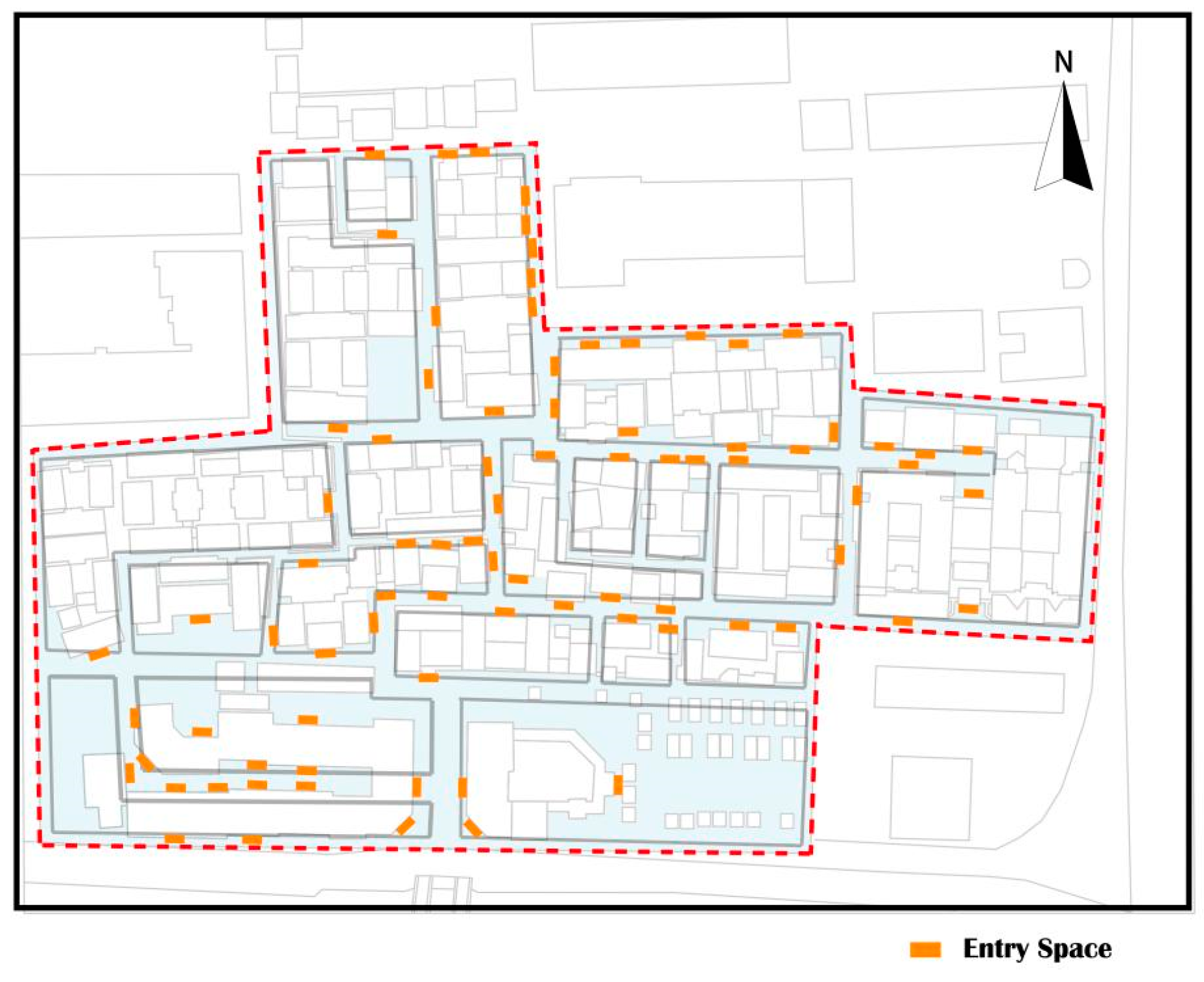
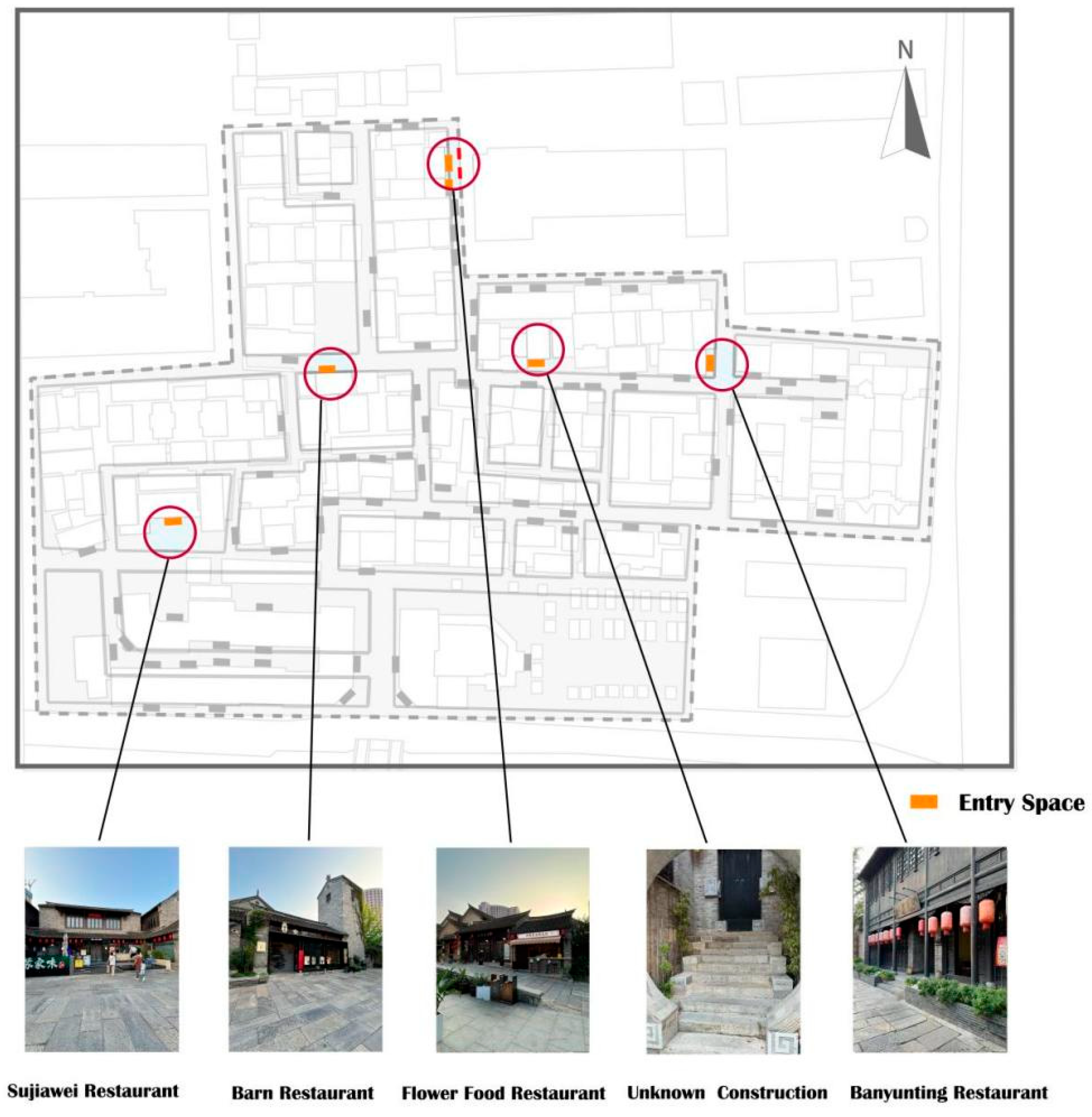
The entry space serves as the interface between a building’s interior and exterior, necessitating a blend of public and private characteristics; entry spaces are relatively densely distributed, as illustrated in the location marker map (
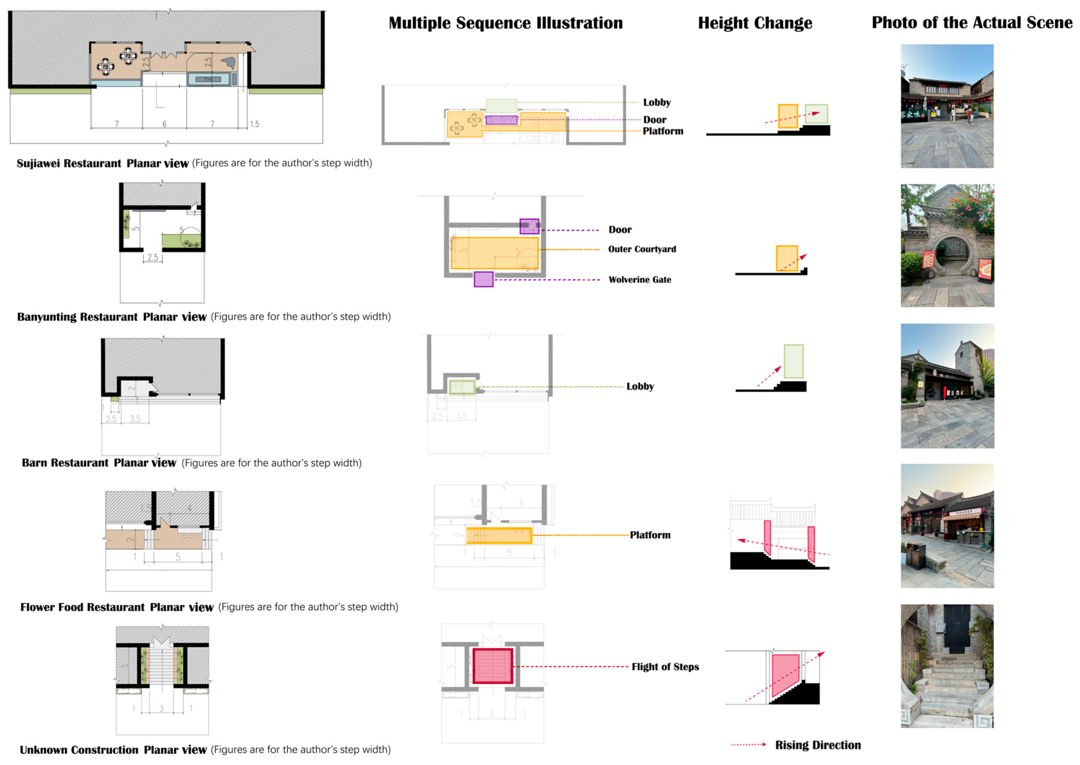
Figure 25). The genes in entry spaces pertain to the structural arrangement of the various spatial elements, including lobbies, courtyards, corridors, and platforms. These elements create multiple sequences influenced by height variations.
Field research identified 11 typical entry spaces, providing a comprehensive summary of their characteristics within the district. Based on this analysis, entry space constituent elements and flow lines can be categorized into courtyards, corridors, and platforms.
4.2.1. Courtyard Spatial Sequence
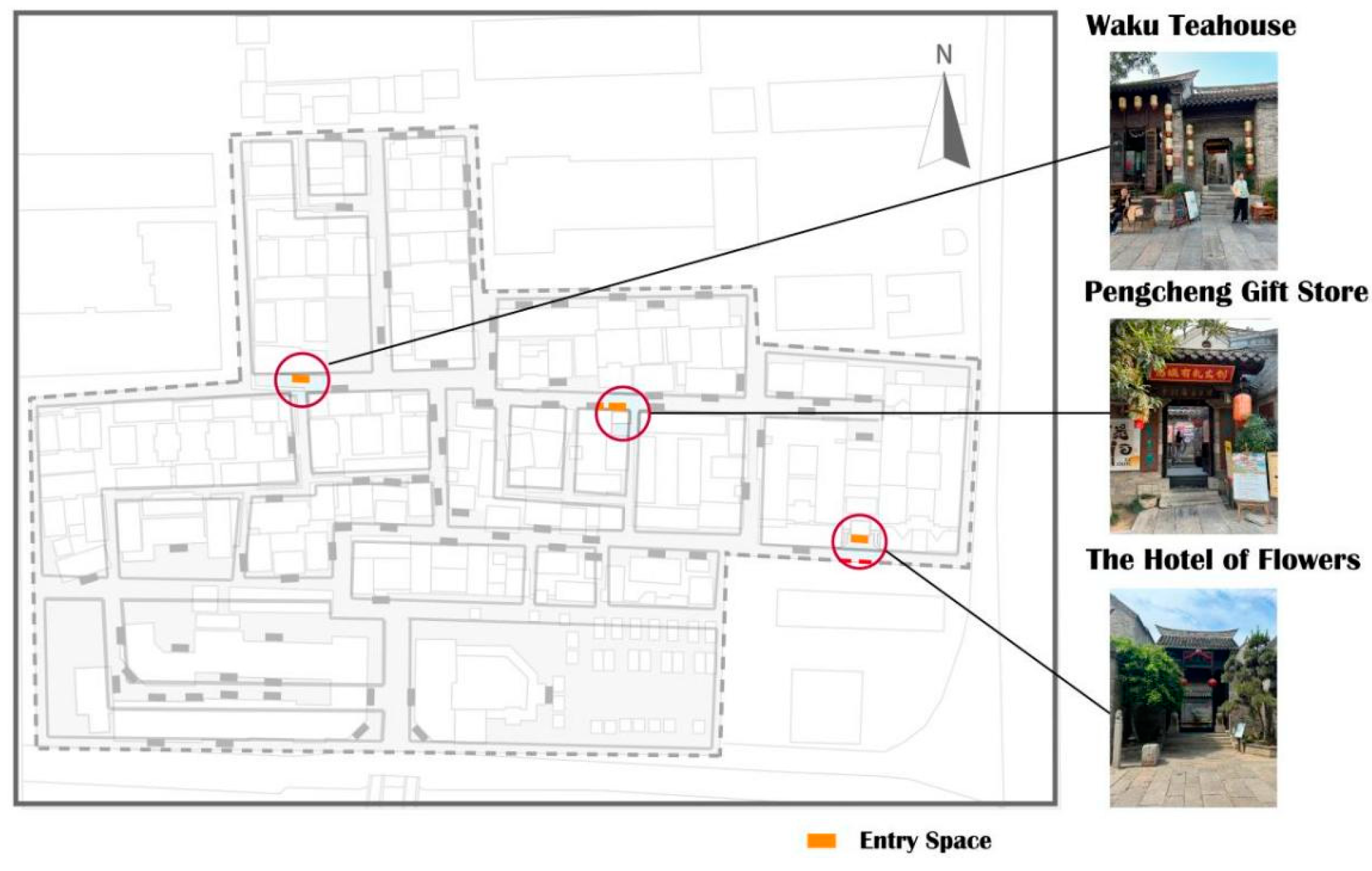
The courtyard spatial sequence refers to the combination of an entry space sequence with a courtyard. In Huilongwo, there are several courtyard spatial sequence types, such as “door–outer courtyard–lobby–corridor–inner courtyard”, “door–outer courtyard–lobby”, and “door–lobby–inner courtyard”. Here, the courtyard spatial sequence characteristics are exemplified by the Hotel of Flowers, Pengcheng Gift Store, and Waku Teahouse (
Figure 26).
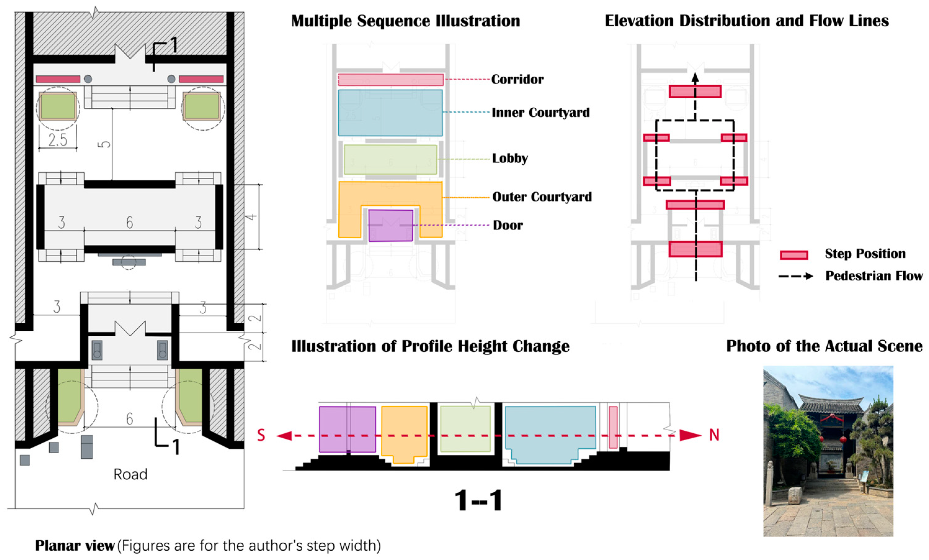
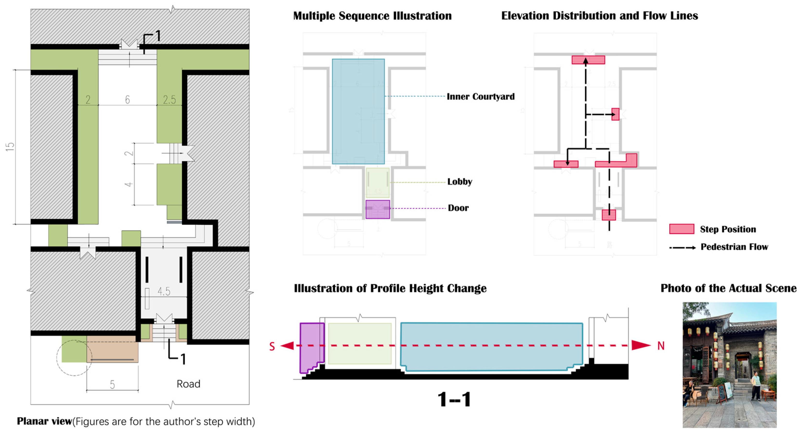
The Hotel of Flowers is in the southwest of the district and uses a “door–outer courtyard–lobby–inner courtyard–corridor” sequence to realize the change from the external road to the internal space. After entering the house, the flow line diverges on both sides and then gathers again, reflecting the symmetry of the axes. In cross section, the height of the ground behind the door is higher than that of the external road, and the height of the lobby and architectural interior is higher than that of the courtyard, finally reaching its highest level at the end of the sequence. Pedestrians experience multiple height changes, and the spatial flow is greatly enriched (
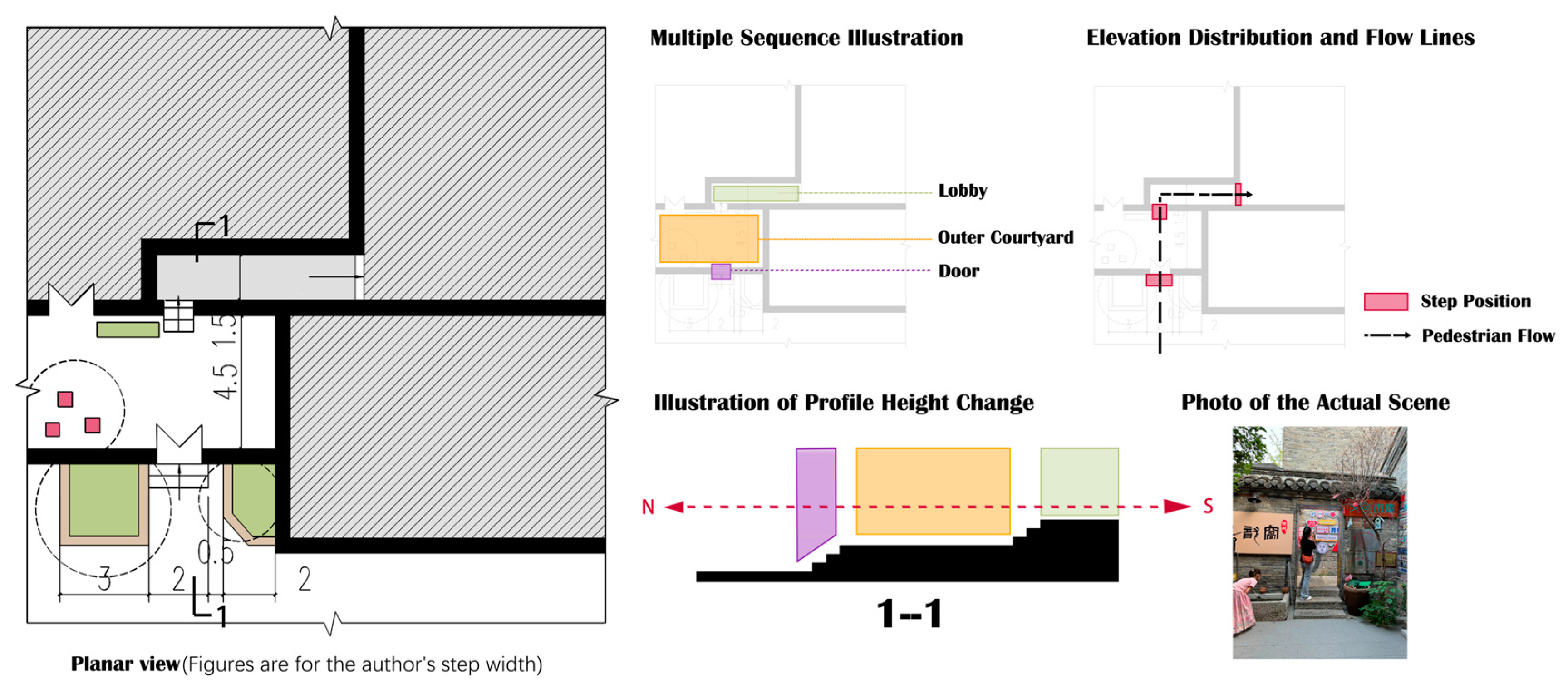
Figure 27). Pengcheng Gift Store is on the main road, with a “door–outer courtyard–lobby” sequence and a noticeable turning feature. The mansion door and architecture entrance are not on the same axis, and the two flow lines are perpendicular to each other. This approach significantly improves the space’s privacy and breaks the strong axis symmetry (
Figure 28). Waku Teahouse is in the west of the district, with a “door–lobby–inner courtyard” sequence. People flow radially; after entering the inner courtyard, the flow is dispersed to each architectural point rather than showing a symmetrical relationship with a clear axis (
Figure 29).
Although the above three entry spaces do not have the same spatial composition, they have a similar generative logic; that is, they form internal high and external low characteristics through steps to increase the space’s privacy and use the lobby or courtyard to break the spatial continuity, adding interest to the architecture’s internal path, in contrast to the closed façade.
4.2.2. Corridor Spatial Sequence
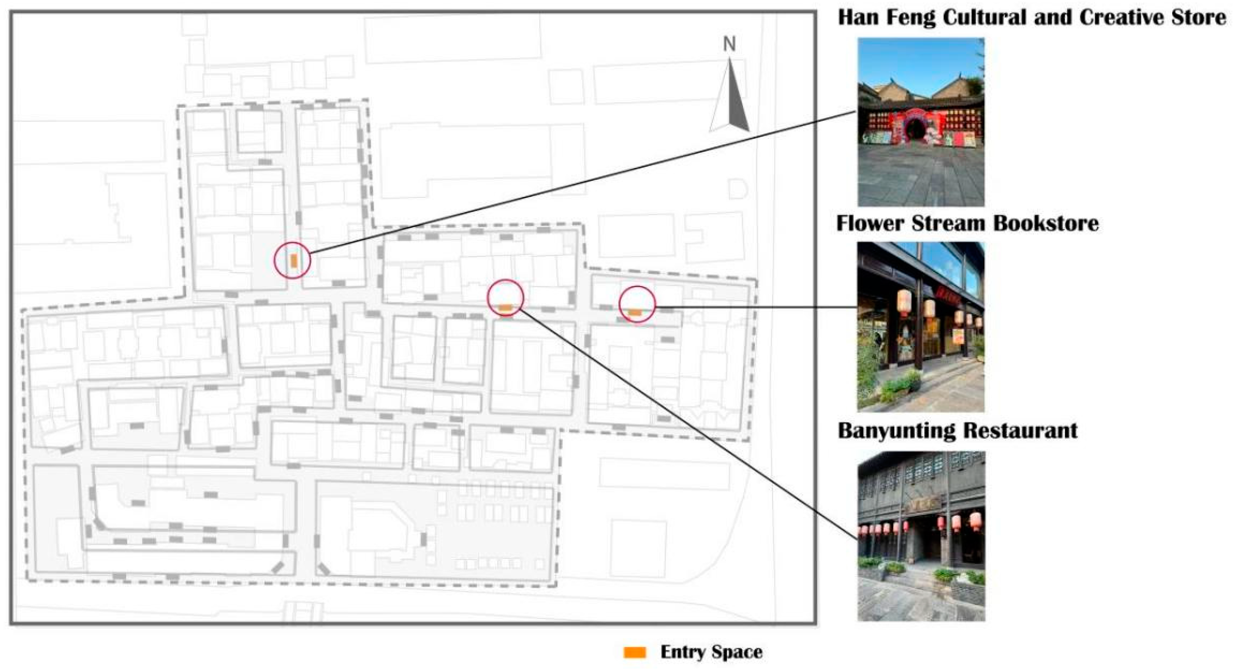
The corridor spatial sequence combines the entry space sequence with the corridor as the primary orientation. Huilongwo district has several types of corridor spatial sequences, including “door–corridor–lobby–inner courtyard”, “corridor–lobby–door”, and “corridor–door”. Below, the courtyard spatial sequence’s characteristics are exemplified by the Hanfeng Cultural and Creative Store, Banyunting Restaurant, and Flower Stream Bookstore (
Figure 30).
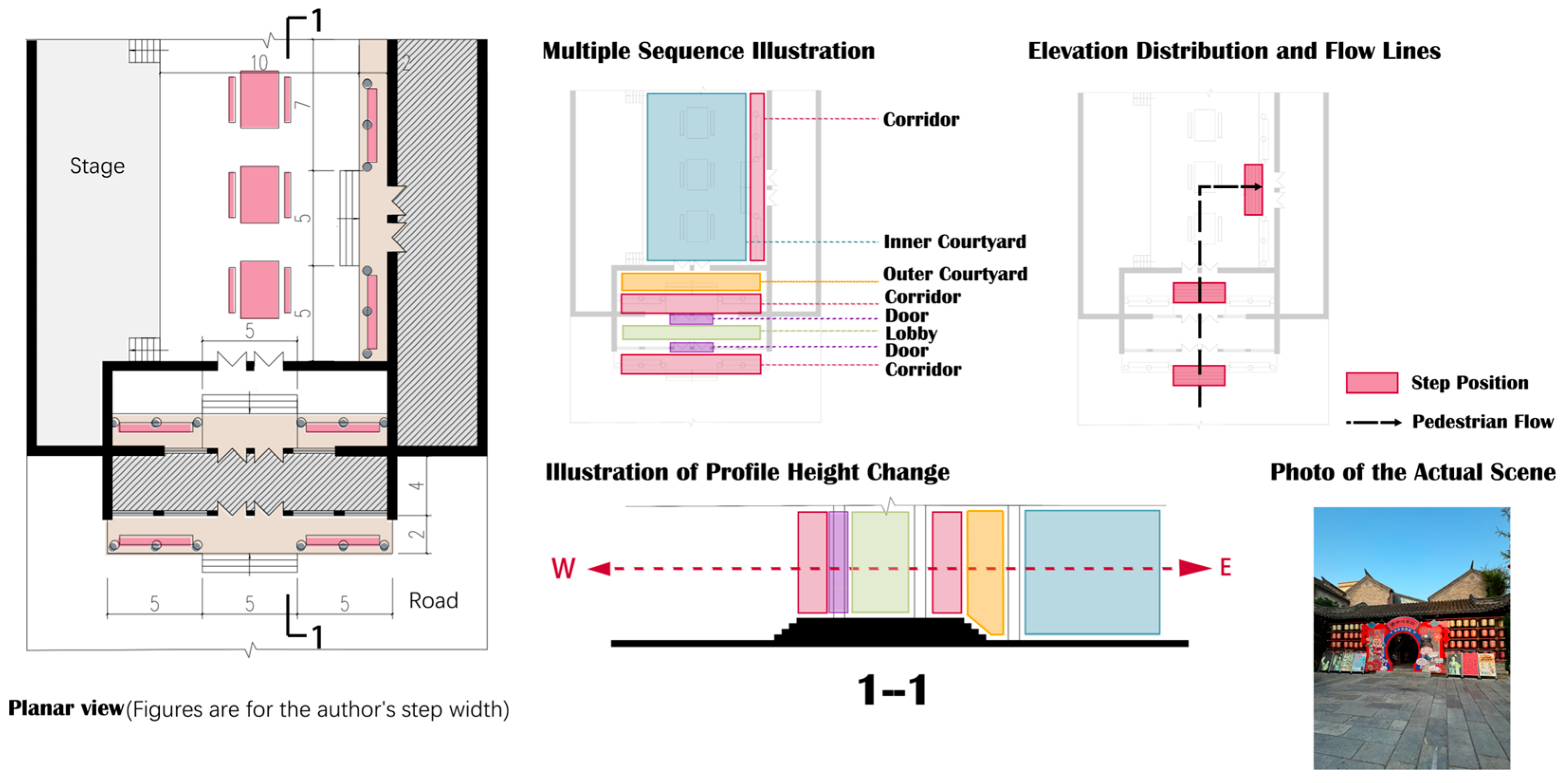
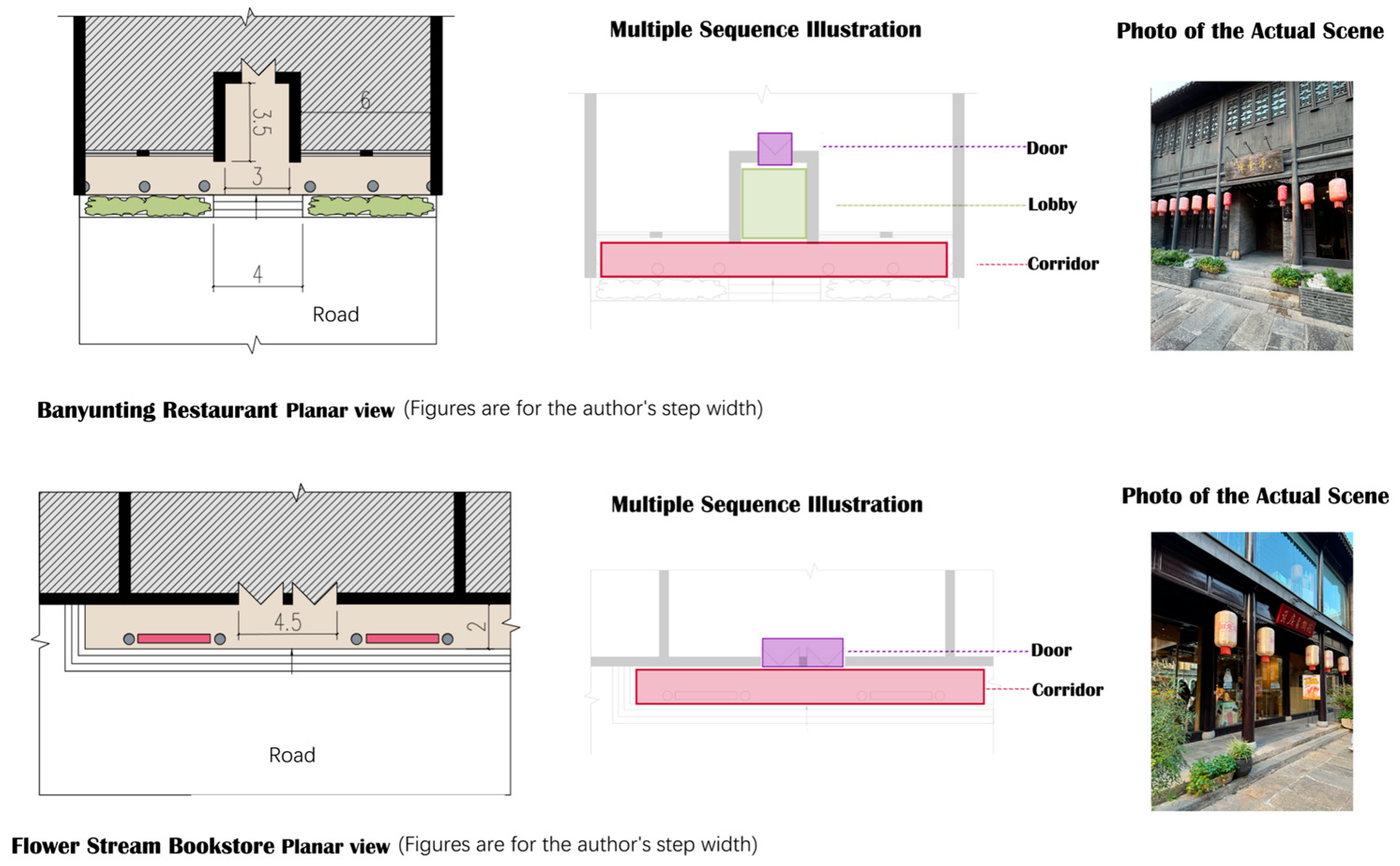
The Hanfeng Cultural and Creative Store is in the east of the district. It is open to the square and establishes a connection between the internal and external spaces through the corridor, that is, the spatial sequence of “corridor–door–lobby–inner courtyard”. The corridor in front of the entrance serves as a long, narrow passage connecting the indoor and outdoor spaces while providing a resting place (
Figure 31). The “corridor–lobby–door” sequence of Banyunting Restaurant and the “corridor–door” sequence of Flower Stream Bookstore are similar. As the entry space levels decrease, the boundaries between the internal and external spaces become clearer (
Figure 32).
The corridor space sequence is shallow, and the horizontal space extends to both sides. Compared with the multiple spatial experiences of the courtyard spatial sequence, it focuses more on the transition and communication between internal and external spaces, weakening the spatial boundaries. People travel through this entry space in less time, but the boundaries between the inside and outside are less noticeable.
4.2.3. Platform Spatial Sequence
The platform spatial sequence combines the entry spatial sequence and the platform as the primary spatial orientation. In Huilongwo district, there are several types of platform spatial sequences, such as “platform–door–lobby”, “moon gate–courtyard–door”, and “platform–door” (
Figure 33).
Sujiawei Restaurant is in the southwest of the district and faces a square. In the courtyard entry space, although the courtyard is in front of prominent architecture, the door divides people’s internal and external flows, so the courtyard shows internal closure. By contrast, the Sujiawei Restaurant uses its architecture’s concave shape to form an open platform, creating a spatial sequence for the platform, door, and lobby. The inner courtyard’s externalization has resulted in more open architecture. Similar to the logic of generation is the “moon gate–courtyard–door” sequence of Banyunting Restaurant. The half-open moon gate makes the courtyard extroverted, and the dislocation of the inner and outer doors and spirit wall increases the pleasure of exploring. The height difference between these two types of spatial sequences is not evident, reducing the perception of spatial change and blurring the boundaries between the inner and outer spaces.
This elaboration of the sequence of entry spaces in Huilongwo district reflects possible paths between the external road and the architectural interior. Additional entry spaces directly differentiate between the inside and outside with a passageway or door, except for multiple entry space sequences. For example, Barn Restaurant is south of the central square and reflects the “lobby–door” sequence, with a simple flow of people and clear boundaries between internal and external spaces. Some space is also combined with terrain. For example, the Flower Food Restaurant is located at the district’s northeastern boundary, and the entrance platform is integrated with steps and slopes. This approach integrates terrain into an entry space. The terrain is additionally managed by using multiple steps to elevate the door, which can effectively stagger the view of the external pedestrian flow and architectural entrance, establishing clear architectural boundaries and improving privacy (
Figure 34).
The platform spatial sequence is simple, and the spatial characteristics are expressed more outdoors. Compared with the previous two spatial sequences, which focus on the layers of space, the platform spatial sequence makes it easier to integrate the terrain into the entry space design and shows characteristics influenced by microtopography.
In summary, Huilongwo district’s entry space is characterized by the coexistence of single and multiple spatial sequences that are mainly composed of doors, courtyards, lobbies, corridors, platforms, and other elements. Huilongwo district’s entry space does not have strict central axis symmetry, and the spatial changes are more flexible because of Huilongwo’s microtopographical characteristics, which combine with differences in height through ramps or steps to form a unique entry space.
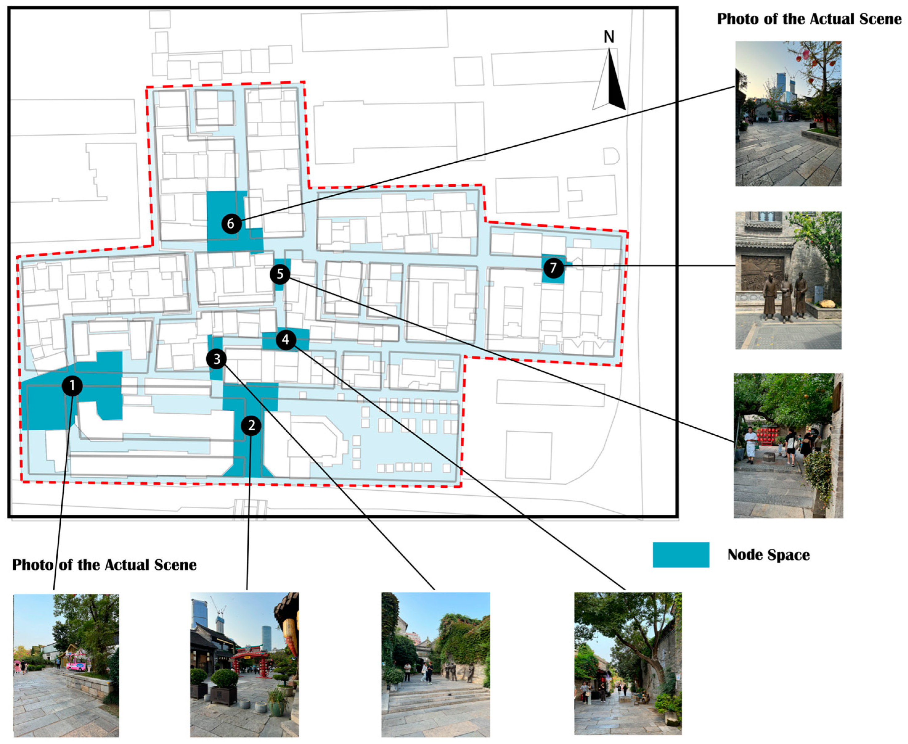
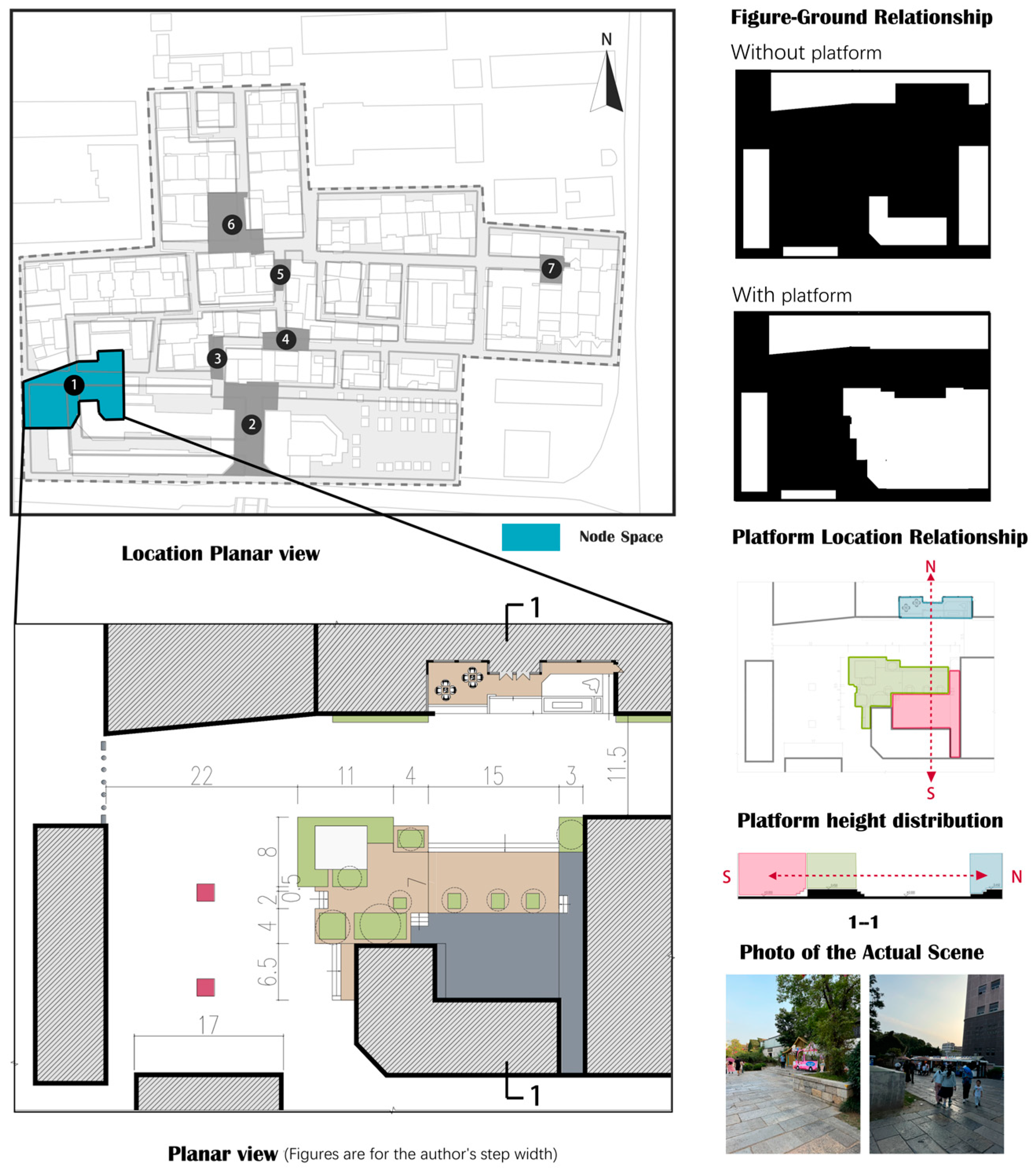
4.3. Node Space Multi-Morphological Analysis
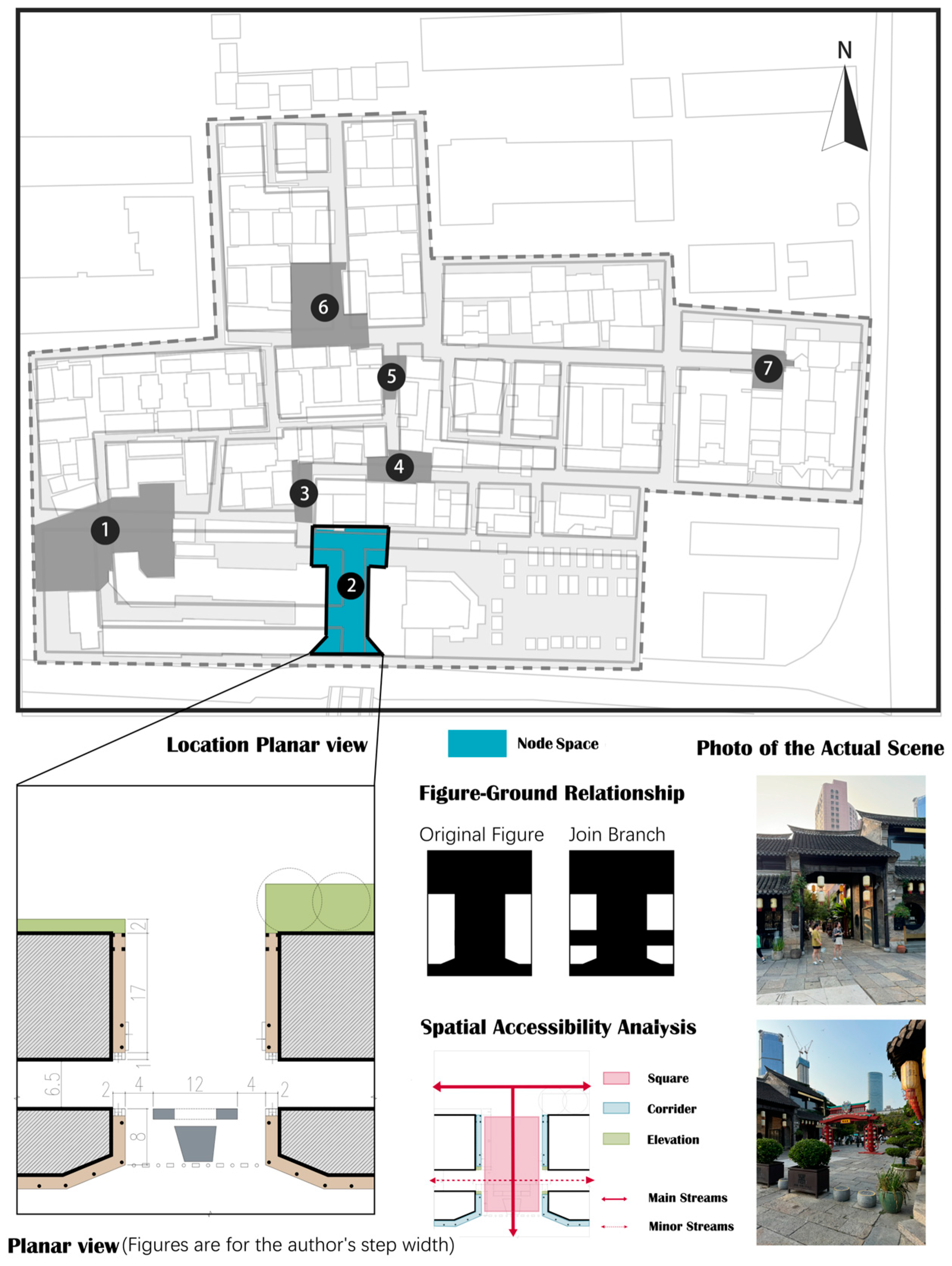
The node space can interrupt the pedestrian’s tour path and achieve the effects of starting and ending the entire district. The different node space functions in Huilongwo are as follows: first, as entrances and exits, mainly located at the site boundary; second, as a square, often located in the site center and connected with several roads; third, as a transition space for different architectural groups; fourth, as an interruption of streets and alleys; and fifth, as a prelude to the architecture, primarily located at the road’s end. Based on these functional differences, seven nodes were selected for element extraction (
Figure 35). Internal generative logic is thoroughly investigated through planar morphology characteristics, figure–ground relationships, height differences, spatial flow and accessibility, and architectural boundaries to summarize the five types of node space genes with local characteristics.
4.3.1. Multi-Height Platform Space
Node 1 is at the district’s southwest entrance and is characterized by a half-enclosed square formed by the expansion at the end of the alley. This node features three resting platforms at varying heights strategically positioned along the north–south axis between the alleys and the buildings. In terms of figure–ground relationships, the node offers a spacious open area in the absence of platforms, whereas the introduction of these platforms alters the planar shape to a sickle form. Outdoor platforms can effectively redefine the nodes’ spatial dynamics. With its layered setbacks, the sawtoothed interface creates a square that serves specific functions. Tall greenery surrounding a platform enhances the space’s privacy, visually elongates the alley, and diminishes the square’s perceived size, thereby encouraging people to move deeper into the site (
Figure 36).
4.3.2. Intersections
Node 2 is in the district’s southern square, opens on all sides, connects to alleys on all three sides, and accommodates a large flow of people. Alleys widen accessibility while reducing the burden on crowds in the square. The corridor blurs the boundary between the inner and outer spaces, and the steps establish the boundary between the architecture and the square. The spatial elements are simple, and large gaps allow the crowd to understand the site before entering. The regular and straight boundaries and the surface interface with no noticeable height difference emphasize its functional attributes as the main entrance (
Figure 37).
4.3.3. Overall Street Deformation
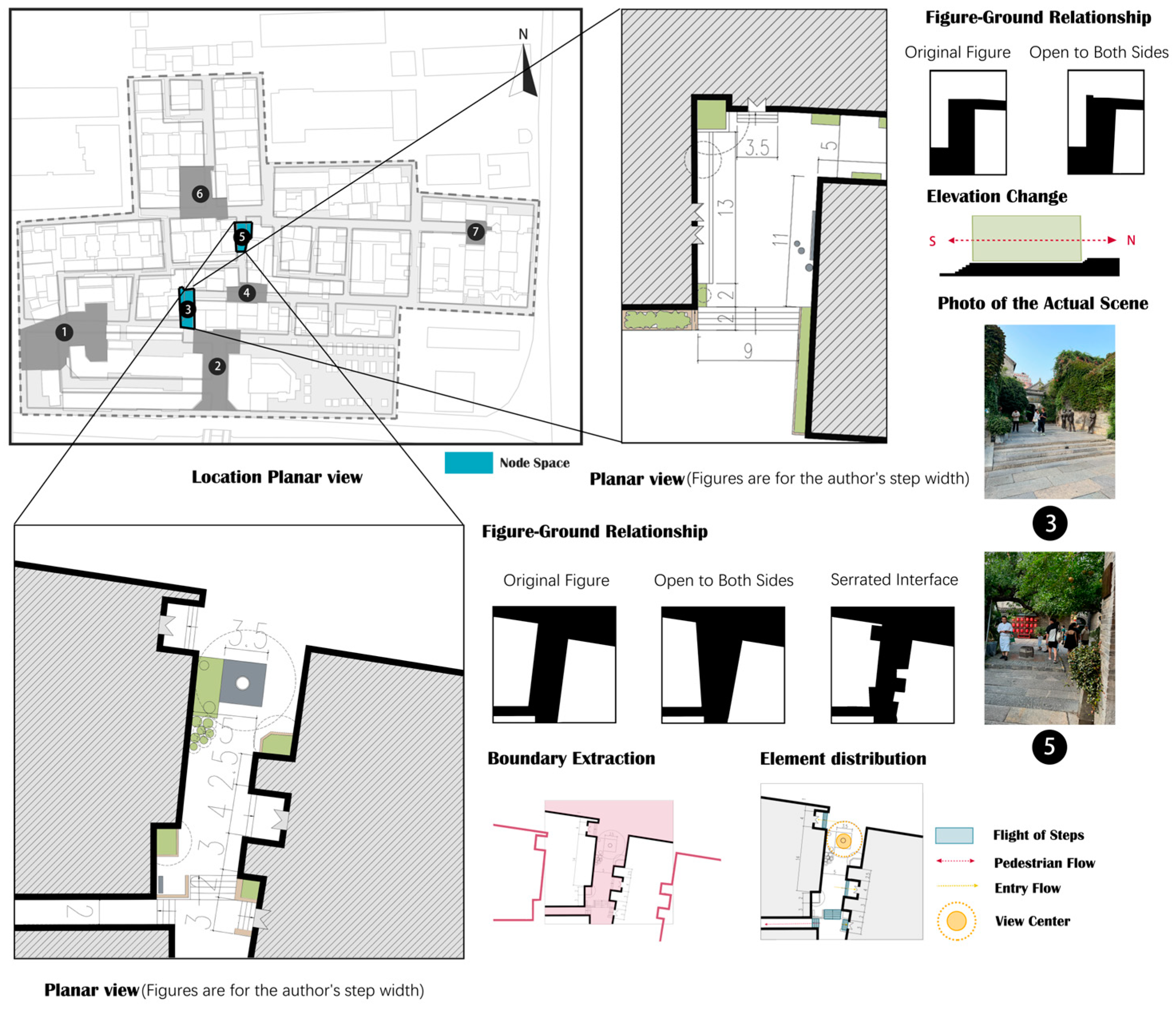
Deformation has changed the width of the alleys, presenting contraction or opening on one side. Node 3 is a small square close to the west and south squares of the district, and the steps establish the boundary of the space, which is characterized by the architectural orientation. Xuzhou folklore sculptures attract people and provide nodes with a specific function to improve space utilization. A similar approach is reflected in Node 5, which is on the side of the alley, showing a narrow-to-wide pattern and enlarged into a node at the end, which is the transition space for southbound people to enter the central square. From the figure–ground relationship, the entry spaces on both sides of the alley recede to form a sawtoothed interface. There are several steps to raise and divert people to reduce crowd pressure. An old well becomes the landscape center, and the appropriate height of greenery radiates outward, blocking people’s view while improving their privacy (
Figure 38).
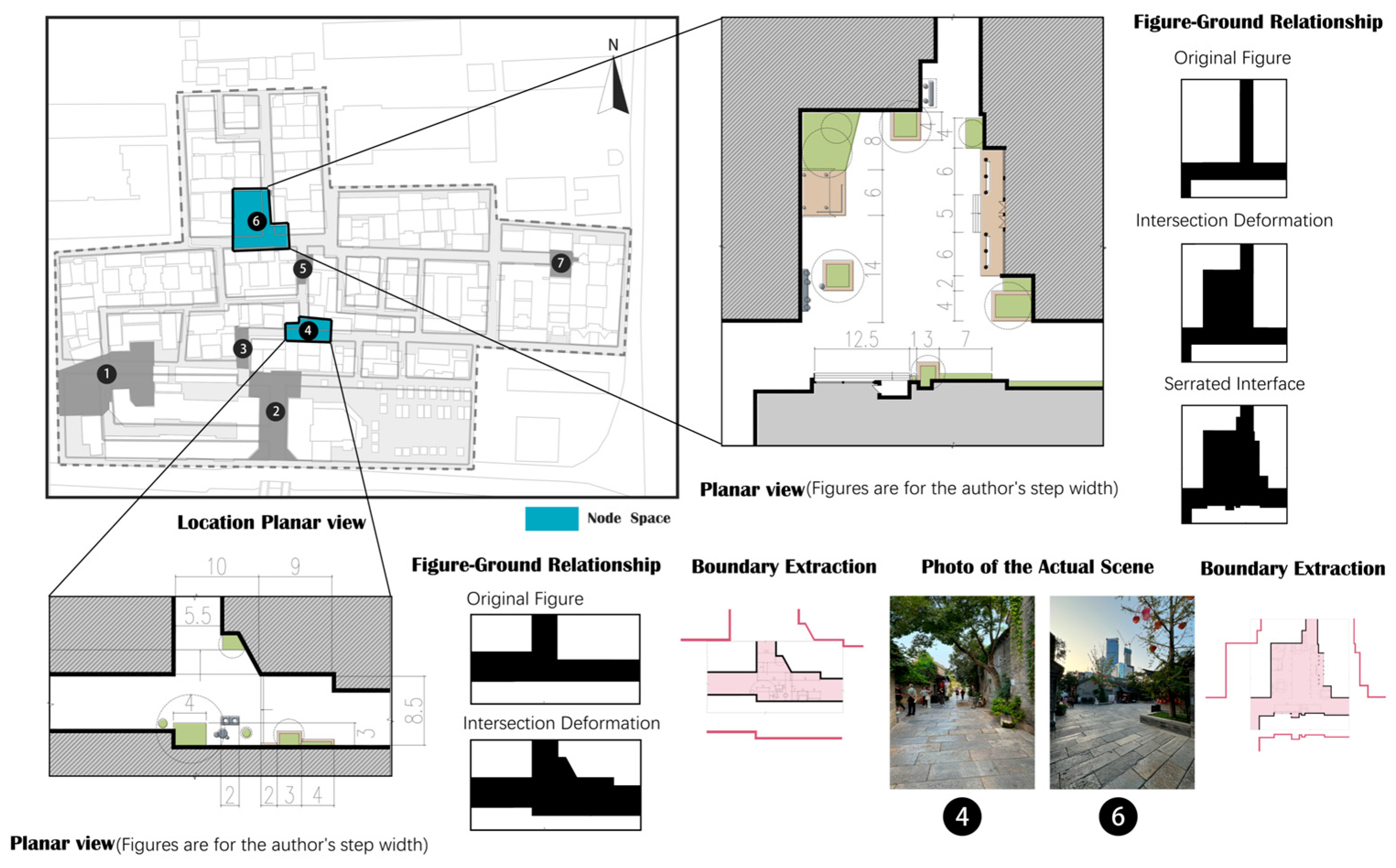
4.3.4. Localized Street Enlargement
Intersections of multiple alleys often form spatial nodes. Different scales can affect the nodes’ spatial interfaces. Node 4 is in the district center; the architectural boundaries are set back and partially sloped so that part of the alley is enlarged, and the steps establish spatial boundaries, forming a smaller transitional space. A sculpture forms a visual focus, interrupting the alley’s continuity and monotony. However, the architecture has limited setbacks and is small, creating a weak crowd-gathering effect. Node 6 is a square formed by the intersection of two perpendicular alleys; it is more prominent in scale and has a more substantial crowd-gathering effect. The architecture setback forms a sawtoothed boundary, which aligns with Huilongwo’s figure–ground relationship characteristics. The site has pavilions, sculptures, rockeries, and other landscapes rich in elements and functions, mainly for crowd gathering and rest. The space’s sudden enlargement at the end of the alley creates a visual effect of openness where multiple streams of people converge, enriching the flow and activating vitality (
Figure 39).
4.3.5. Turning Space
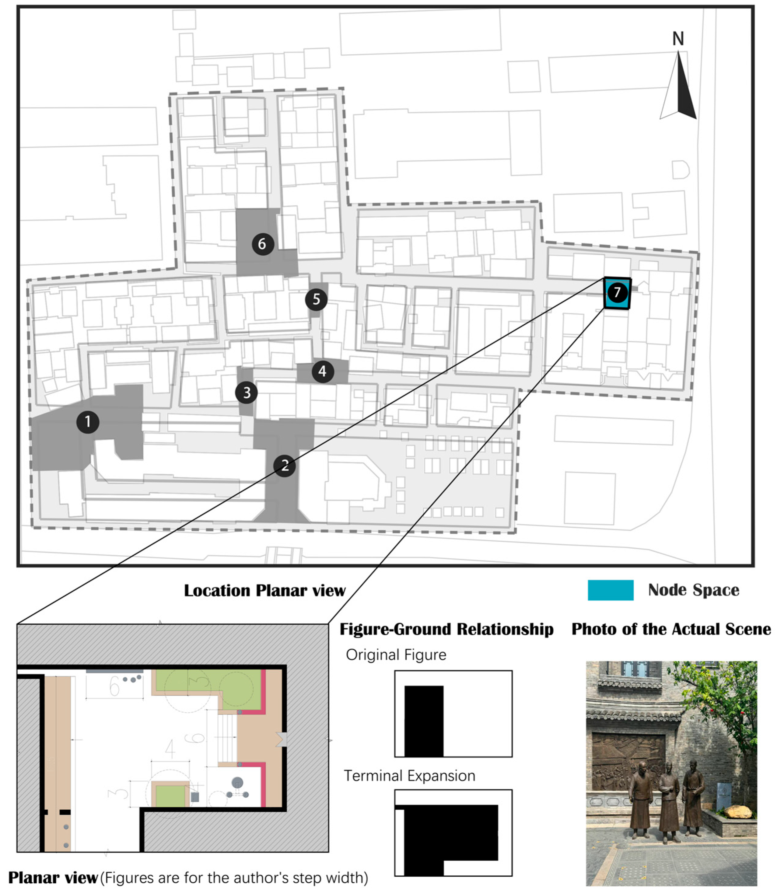
Node 7 is in the east of the district, formed at the alley’s end, and it differs from the above-mentioned node spaces; it does not have rich flow lines and spatial combinations and only combines with architectural entrances to form a square in front of it. From the figure–ground relationship, the interface is flat and straight, and a unique spatial atmosphere is created through steps, corridors, sculptures, and greenery, which weakens the space’s closure because it is deep at the end of the alley; accessibility and publicity are weak (
Figure 40).
In summary, the Huilongwo district’s node space presents different spatial forms owing to differences in location, element composition, and function. Results show that some node spaces have terrain-based height differences and are managed with steps or ramps. Unique sawtoothed interfaces are formed by the district’s diverse architectural orientations.
6. Conclusions
Based on our comprehensive analysis of Huilongwo district’s street segments, entry spaces, and node spaces, we summarized the characteristics of each type of space to construct a spatial gene system of streets and alleys. The street segment is based on the microtopographic features of Huilongwo, such as its irregular architectural orientation, resulting in height differences and irregular interfaces, which are also reflected in the façade outlines. The entry space is not strictly symmetrical and is characterized by the coexistence of single and multiple spatial sequences. Multiple spatial sequences mainly comprise different entry space elements, such as doors, courtyards, lobbies, corridors, and platforms, and form height differences through steps. Terrain affects the single-space spatial sequence to externalize the entry space’s characteristics. It generates various planar forms based on Huilongwo’s terrain: multi-height platforms, intersections, overall deformation, localized enlargement of streets, and turning spaces. Different locations and functions influence the nodes’ spatial morphology. In summary, Huilongwo district’s streets and alleys have unique spatial genes based on terrain, architectural orientation, and function.
Some recommendations could sustainably develop and conserve the study subject and similar areas. First, microtopography should be considered in the conservation of historical districts, and policymakers should refine and preserve the existing spatial genes produced by terrain changes. Next, the role of streets and alleys in historical district conservation is important. Void spaces outside the architecture are essential public spaces in historical districts. Third, a scientific system of street and alley spatial genes that is conducive to their systematic inheritance and protection should be developed. This study summarizes microspatial features through graphics and constructs a spatial gene system of streets and alleys under the influence of microtopography, clarifying the combination rule and serving as a basis for spatial research on historical districts with microtopographic features.
This paper has some limitations. First, we mainly used qualitative research methods, and the research scope is limited, lacking comparison with other cases. Second, we focused on identifying and classifying spatial genes in historical district street spaces and did not establish the relationship between spatial genes and population cognition and dynamics. In the future, we will attempt to survey populations and establish a relationship between spatial genetics and population cognition to further improve the spatial genetics system.


