Article

Sustainable Transformation of Post-Mining Areas: Discreet Alliance of Stakeholders in Influencing the Public Perception of Heavy Industry in Germany and Poland

by
Anna Szewczyk-Świątek
Faculty of Civil Engineering and Resource Management, AGH University of Krakow, Al. Mickiewicza 30, 30-059 Kraków, Poland
Sustainability 2025, 17(19), 8567; https://doi.org/10.3390/su17198567
Submission received: 16 August 2025 / Revised: 20 September 2025 / Accepted: 21 September 2025 / Published: 24 September 2025
(This article belongs to the Special Issue Sustainability and Innovation in Engineering Education and Management)

Abstract

The sustainable transformation of areas associated with mining is an essential contemporary challenge. In the course of such transformations, economic benefits are confronted with community criticism of heavy industry. In this context, the study examines spatial solutions implemented in the revitalisation of areas adjacent to active industrial sites. The article aims to characterise solutions applied in locations that elude a straightforward division into industrial and post-industrial. The motivations of the entities involved in the construction and the effects of implementing such projects are investigated. To achieve this aim, compositional and visual linkages in four locations (in Germany and Poland) were analysed, along with the intentions of designers and investors and the opinions of users. The study revealed the influence of political decisions on spatial solutions, an aspect not previously analysed, which has led to a limited understanding of the role they play in the transformation. It was indicated that drawing users’ attention to the aesthetic values of active industrial areas coincides with diverting attention from their nuisances. The discreet cooperation between local authorities, designers, and industry (as expressed in architectural solutions) was emphasised. The research opens a field for discussion on managing community perceptions through spatial solutions.

1. Introduction

1.1. Post-Mining Areas and Heavy Industry

Against the backdrop of the difficulties and time-consuming nature of redeveloping post-mining areas, and the need for sustainable development of the resource-rich regions, it is worth noting a theme that has been neglected in the literature: the presence of active industrial areas in the vicinity of newly created public spaces on post-mining sites. Although researchers (e.g., [1]) point out that the term “post-industrial” may (falsely) suggest that the area is devoid of industrial functions, the mutual influence of industrial and post-industrial areas in the context of redeveloping post-mining sites has been overlooked in previous studies. The term “post-industrial” is widely used to describe the changes that have taken place since the mid-twentieth century: the phasing out of industrial activities and their relocation to other parts of the world, currently further driven by the pursuit of achieving zero-emission economies (e.g., [2,3]) and zero-emission mining operations [4]. A substantial body of literature has been devoted to the issue of traces of industrial activity remaining in the landscape: the transformation of sites, structures, and infrastructure, which may be reused, demolished, or abandoned. Many studies emphasise the importance of preserving buildings exploited and abandoned by industry, including mining, due to their historical, utilitarian, aesthetic, and economic value (e.g., [5,6]). Publications can also be found that point to the possibilities of adapting industrial infrastructure (e.g., [7]). There are numerous publications on the use of post-industrial heritage for tourism and recreation purposes: drawing attention to the importance of aesthetic solutions that seek to preserve idealised forms of industrial objects, fetishise ruins [8] or restore objects in the process of ruination, accentuating signs of their dereliction [9]. However, it is challenging to identify works that address the issue of reusing the legacy of mining in areas currently adjacent to heavy industry [10].
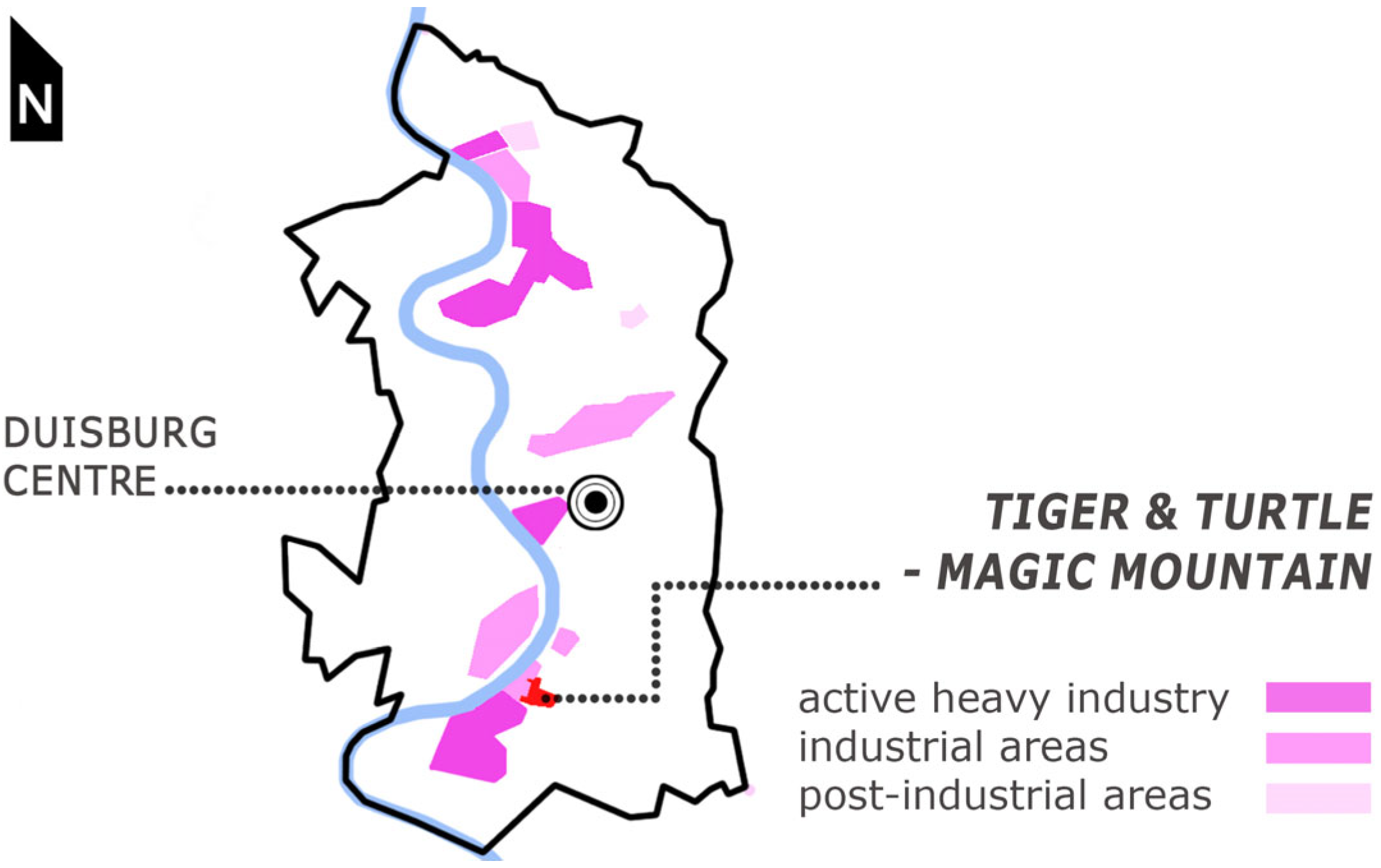
It is worth noting that even in regions considered exemplary in terms of implementing transformation—where, from the outset of the deindustrialisation process, land management was directed towards the abandonment of mining, and the results of transformation are assessed positively (such as in the Ruhr area [11])—heavy industry continues to function to this day (Figure 1).
Referring, for example, to the IBA Emscher Park Memorandum [12]—the first German international building exhibition, whose aim was to comprehensively support the structural transformation of a region affected by deindustrialisation—it becomes clear that the continued presence of industry in this region is not accidental. In IBA Emscher Park, a project that has served as a benchmark for subsequent revitalisation programmes, the objective was to diversify modes of production while recognising that heavy industry would not be dominant, but would remain a developed and important element of the economy [12] (p. 34). In the literature, we can find works devoted to the problems of clashing interest groups and different narratives in the process of industrial landscape musealisation and land transformation. Researchers (e.g., [13,14]) argue that choosing the directions of transformation and connecting stakeholders who represent, often different, visions of the future of the revitalised area is a strictly political task—a frequently conflictual process of deciding on a common resource, which the transformed space is, and seeking a dominant influence over it. However, they do not devote sufficient attention to the influence of representatives of active industry on architectural and urban solutions. Among the few authors who note the interconnection of post-industrial and industrial areas, it is worth mentioning Shaw’s paper [15] in the context of this work. He signals the cooperation between heavy industry corporations and political institutions in the decision-making process regarding the redevelopment of post-mining areas adjacent to heavy industry. However, neither he nor others have analysed the impact of this cooperation on architectural and urban design solutions.
Contemporary literature on post-mining areas primarily focuses on the necessity of designing redevelopment for land vacated by coal mining as a consequence of the energy transition. However, it is also important to emphasise the significance and necessity of adapting land after the extraction of other minerals, including commonly used aggregates. In this article, it is pointed out that the methods developed for the revitalisation of post-coal-mining areas have their counterparts in areas exploited for other minerals. The cessation of their extraction is not under discussion. However, the opening of new mines—often in the vicinity of depleted sites—is the subject of increasing interest (and usually opposition) from local communities. This constitutes a costly problem for companies, as well as for municipalities whose budgets depend on revenues from such activities.

1.2. Public Spaces in Post-Mining Areas and “Wild” Greenery

In the context of sustainable development, the recognition of an area as post-industrial generates the need for its redevelopment for new, non-industrial functions. Redevelopment in situations where active industrial and post-industrial areas share the same territory is scarcely addressed in the literature, with the consequence that part of the processes, conflicts, and motivations remain unidentified. In other words, the fact that the presence and redevelopment of depleted areas may constrain or facilitate industrial operations in the vicinity is overlooked, as is the fact that the values of depleted areas (utilitarian, natural, economic, etc.) are either limited or supported by adjacent extraction activities.
Under the law, it is assumed that during the extraction process, the utilitarian and natural values of exploited land will be temporarily lost and that the party responsible for degradation should restore those values. Although, viewed globally, the obligation of a mining operator to define a formally accepted method for ending exploitation is a prerequisite for obtaining permission to commence it, the costs of this final stage are often underestimated [11], and local communities rarely regain space from mining companies that corresponds to their needs and expectations [16]—even if the traditional restoration of pre-mining land functions is increasingly being replaced by the aim of reusing such land for the development of local communities [17].
In the rich history of managing degraded areas, many ideas can be found that aim to give social significance to land no longer needed by industry. Researchers from various disciplines (design, spatial planning, ecology, nature conservation, archaeology, etc.) and designers involved in revitalisation have developed the concept of perceiving abandoned, undeveloped post-mining areas as traces of the history of a place, of economic and cultural change, and as elements of heritage (e.g., [18]). Post-extraction and rewilded areas have become the subject of professional studies indicating their exceptional natural value (e.g., [19]). In contrast, studies are pointing to manipulations that demonstrate redevelopment aimed at concealing the history of a site and its contamination burden (e.g., [20]). In this article, I focus on examples of projects transforming post-mining areas into vast public spaces (thanks to their parameters and traces of industrial heritage, fitting into the creative demand for fitness spaces [21]), not through the lens of changing functions, but of forms that account for the presence of active industry, not (only) industry as a heritage of the past.

1.3. Public Spaces in Mining-Related Areas

Although industrial and recreational uses of land may seem mutually opposed, the creation of public spaces on land from which industry has withdrawn is a well-known (for almost two hundred years) practice in revitalisation. This practice aims to improve living conditions within the urban structure, influencing the increase in property values in the surrounding area. Parc des Buttes-Chaumont (designed by G. Haussmann and A. Alphand)—the transformation of a gypsum and sandstone quarry into a park (completed for the Paris World Exhibition in 1864)—can be considered the first comprehensive project designed with these aims in mind, and one that achieved them. At the same time, the opening of post-industrial areas to the public—whether not fully transformed, altered by natural ecological succession, covered with unmanaged greenery, or even only superficially decontaminated (only in places marked as accessible to visitors), located in proximity to active (and often burdensome) heavy industry—is a contemporary practice that has gained popularity over the past thirty years. Although this is a significant scientific and practical issue, it is not the subject of this paper, which focuses on post-industrial areas classified as safe prior to the implementation of the analysed projects. Neither this assessment nor its principles are questioned here (although there are undoubtedly cases in which such studies would be crucial). Spectacular transformations of heavy industrial sites into publicly accessible green spaces are analysed in the literature in terms of their impact on the urban structure—improving living conditions, increasing land values, and creating a new identity for an industrial region (e.g., [22])—but also in connection with deepening social inequalities and gentrification (e.g., [23]). Publications discussing the impact of active heavy industry on the neighbourhood are scarce. Those that appear focus on environmental and health risks associated with ongoing industrial activity (e.g., [24]). Moreover, some demonstrate that even with the use of modern technologies, risks of environmental pollution and threats to safety remain (e.g., [25,26]). Many questions, however, remain unanswered. What objectives underlie the creation of public spaces in uninhabited areas adjacent to industry? Are spaces located near active industry designed to convince users that they are part of sustainable transformations? Does the transformation of post-mining land into public spaces serve social or economic interests? Do local authorities and entrepreneurs attempt to influence the perception of mining sites by facilitating public access to post-mining areas? How do the transformations of degraded land affect the conditions for conducting industrial activities?
The results of the study suggest that the creation of public spaces adjacent to industrial areas addresses both social and economic needs. The cooperation of planners, architects, municipal authorities, and entrepreneurs remains informal; however, the visibility of active extraction opens the field for interpreting revitalisation projects not so much as those that change depleted areas, but as those that change public perception of heavy industry, enabling its (prolonged) functioning.

2. Materials and Methods

2.1. Materials: Case Study Analysis

Four case studies were selected for the study, involving the creation of public spaces in peripheral, unfrequented, post-industrial locations adjacent to active industrial areas, equipped with sculptural architectural objects that attract users’ attention (landmarks). Three of the four cases analysed below (Tetrahedron, Tiger & Turtle—Magic Mountain, and Bobrowisko Nature Enclave) are award-winning cases, well-known among revitalisation experts and users. The fourth case (Stone Park) is a case study currently being built (2025), modelled on the three previously mentioned projects.

2.1.1. Cases of Revitalised Spaces in the Vicinity of Active Mining Areas in Germany

The research presented in this article dates back to 1995, when on the Beckstraße spoil heap in Bottrop, in Germany’s coal-mining Ruhr area, the first public space was established away from residential areas, featuring a distinctive architectural structure—a landmark (the Tetrahedron)—clearly visible in the landscape and located in proximity to active mining operations.
It can be hypothesised that the intention to open the spoil heap to the public, in the vicinity of burdensome heavy industry, required designers and managers to take into account the specific nature of the surroundings. Based on this well-known, thoroughly archived, and repeatedly described case (e.g., [27,28,29]), which became a model for constructing landmarks (distinctive architectural objects) functioning as viewing points in other peripheral post-industrial areas, the study returns to the late twentieth century to analyse which spatial solutions were applied in their design.
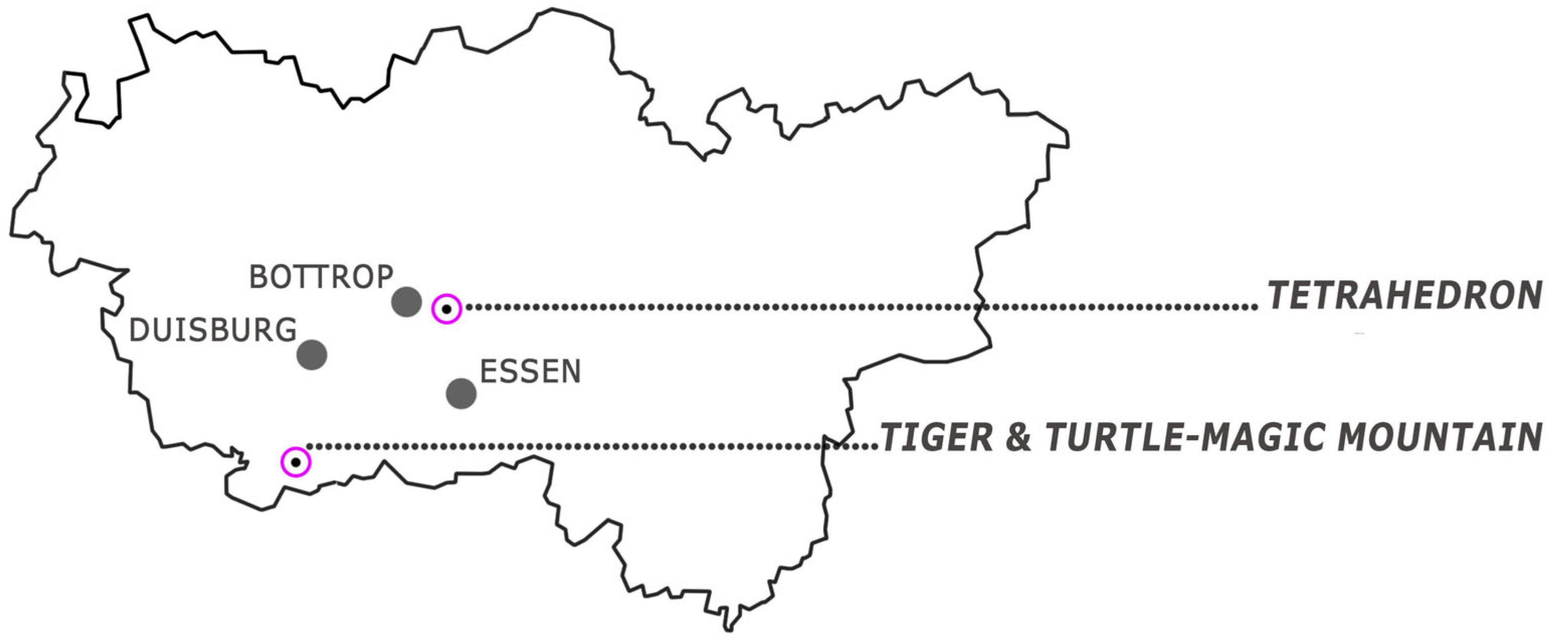
As noted, the construction of the Tetrahedron in Bottrop became a reference point for subsequent projects involving the construction of sculptural structures in degraded areas. Using the example of Tiger & Turtle—Magic Mountain in Duisburg—a hazardous waste landfill situated on the site of a former gravel pit—the study examined whether the applied spatial solutions consider the industrial surroundings. This project, completed in 2011, is more than a decade newer, located in the same region (Figure 2), equally popular, and frequently described as a milestone in landmark design in post-industrial areas (e.g., [30]), which introduces a symbol of fun in industrial areas.

2.1.2. Cases of Revitalised Spaces in the Vicinity of Active Mining Areas in Poland

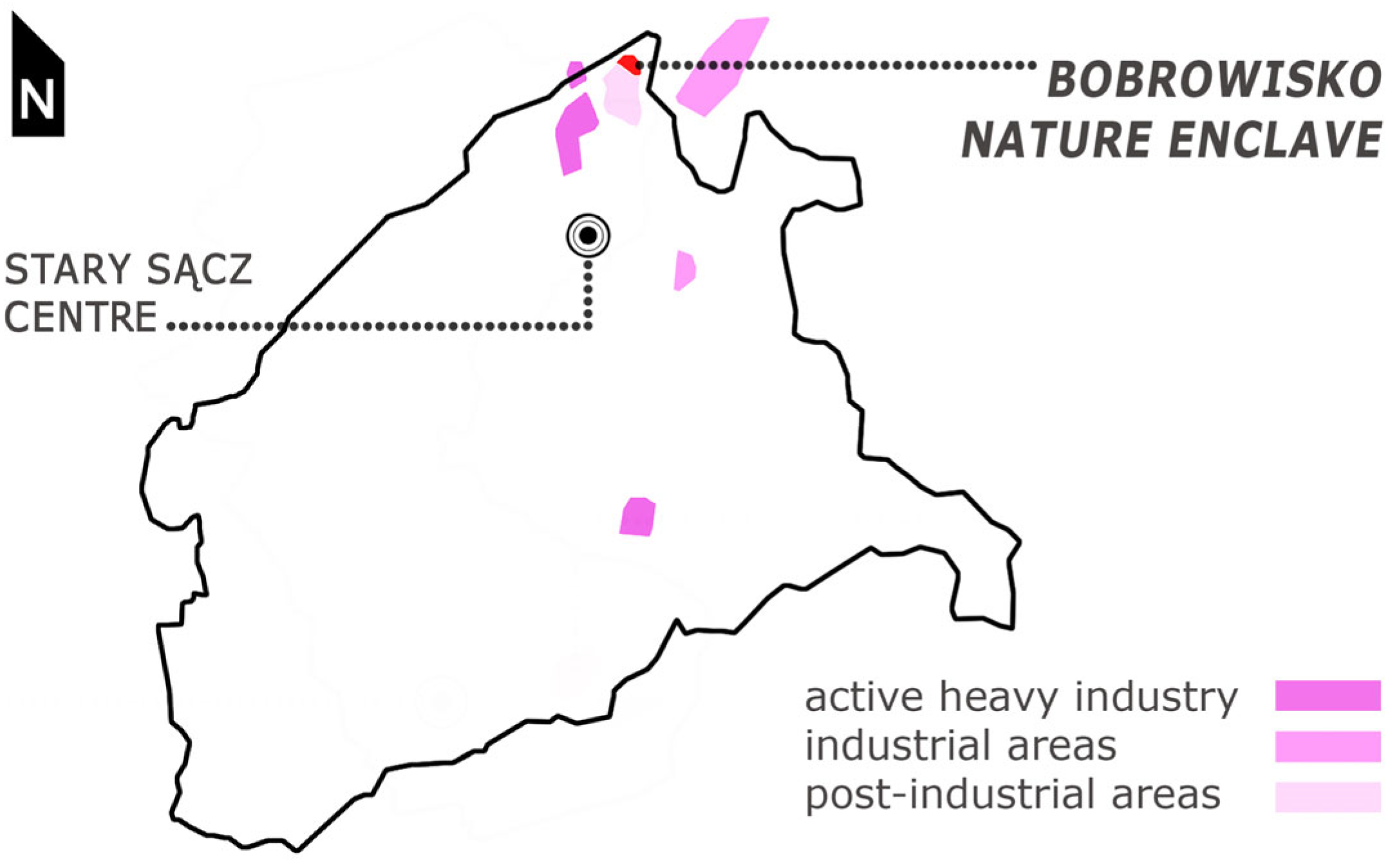
The German cases from the Ruhr Area are compared with two contemporary projects in the Małopolska region of Poland: Bobrowisko Nature Enclave and Stone Park (Figure 3). The revitalisation of coal mining areas serves as a starting point for demonstrating the potential of the methods developed there for application in sites of other mineral extraction, in this article exemplified by gravel mining. Gravel extraction in Poland has remained at a consistently high level for years (approx. 180,000 tonnes/year [31]). Yet, these areas have received little attention in the academic literature. While the balance reserves of this aggregate in Poland are increasing, the exploitation cycles of documented deposits have a shorter time horizon. In 2024, in the Lesser Poland Voivodeship alone (the area analysed here), documented resources reached 1862 million tonnes (an increase of 32 million tonnes compared to 2023) [31]. Efforts to launch new gravel mines are widespread and are linked to the need for mediation between entrepreneurs, local authorities, and residents. They provide examples illustrating the evolution of ideas for developing industrial areas adjacent to other industrial operations.
Two projects are analysed. The first, Bobrowisko Nature Enclave (2018), is a former gravel pit transformed into a public space equipped with landmarks that facilitate observation of the post-mining landscape, dominated by natural ecological succession. The public space was created in proximity to abandoned, active, and planned gravel mines. The project has won multiple national architectural awards and was nominated for the 2022 European Union Prize for Contemporary Architecture—Mies van der Rohe Award and is well-known in the professional community. It enjoys considerable popularity among visitors (>100,000 annually).
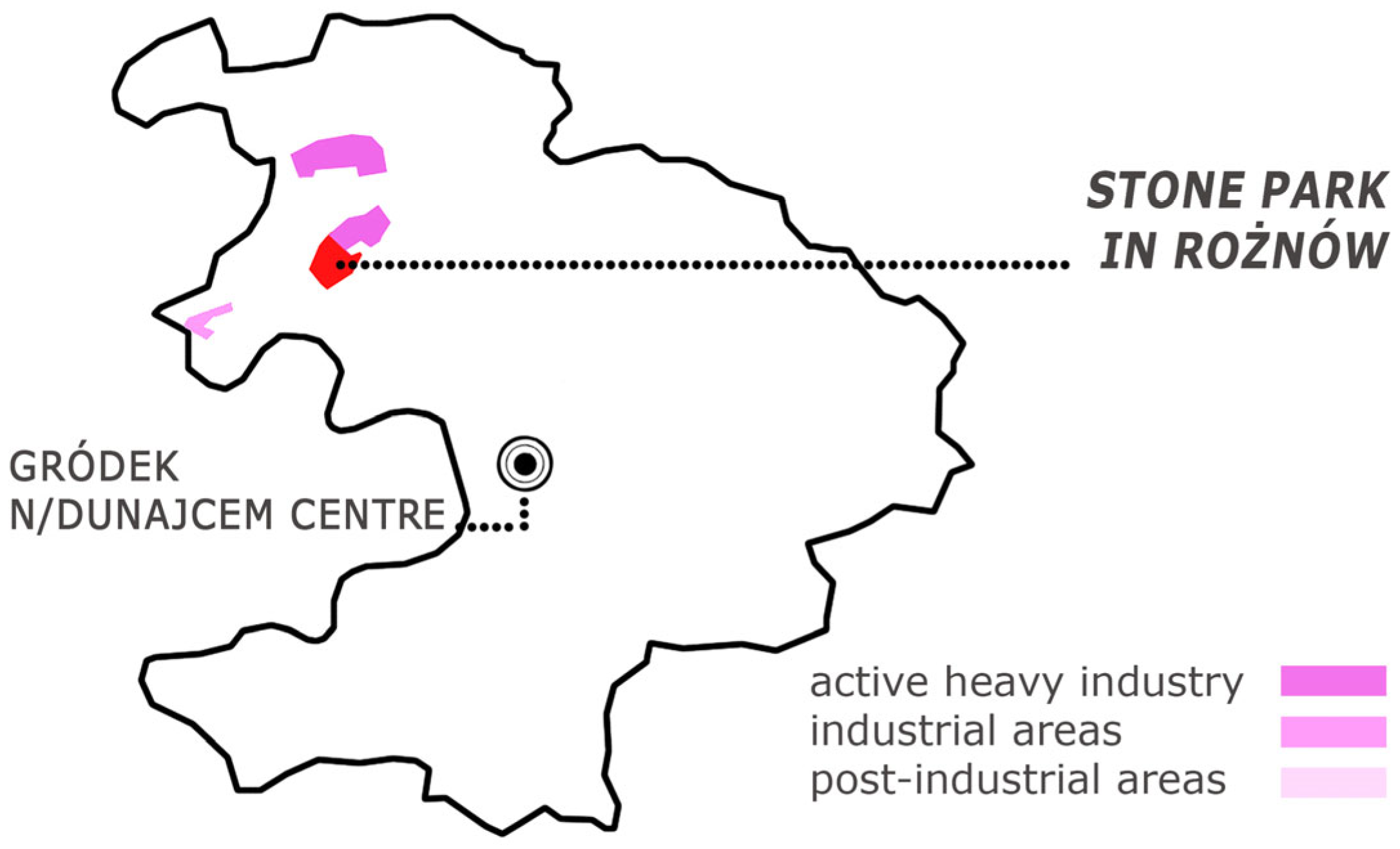
Stone Park in Rożnów (Gródek n/Dunajcem Commune) is an investment currently under implementation (2025). The decision to develop it followed the media and tourist success of Bobrowisko Nature Enclave. There are documented deposits, and ongoing extraction is clearly visible from the area that has been opened to the public.
The main characteristics of all four analysed cases are compared in Table 1.

2.1.3. The Cases That Characterise the Paradigm

The cases selected for analysis are not the only ones that could have been examined—they are treated as a paradigm, a model for forming other projects, that reveals key aspects of reality. The article refers to Giorgio Agamben’s work, What Is a Paradigm? [32], in which the author argues that a paradigm is a fundamental tool for case analysis. Based on the analysis of a single case, a paradigm defines a framework for understanding the group of objects of which it is a part and which it simultaneously establishes [32] (p. 31). In other words, each of the individual cases analysed in the article forms a paradigm that allows for the assessment that there is a previously unnoticed group of objects that can be understood better by examining connections of their form, function and location with active industry in the vicinity.

2.2. Methods

2.2.1. Empirical–Analytical In Situ Research—Quantitative and Qualitative in Germany

This article presents the results of research on two identified design concepts that had not been previously analysed. The inspiration for the study was the conviction that the proximity of active industrial areas was a determinant of the solutions proposed by the designers of the German projects. The first of these concepts is the compositional linkage of degraded areas with active industrial facilities, which sheds light on the methodology of spatial decision-making within revitalised areas. The second concept is the visual linkage of revitalised areas with active industrial facilities, allowing conclusions to be drawn about the significance assigned to them in the landscape. Sources of information on the analysed cases included archival materials, authors’ descriptions, administrative documents, interviews with the creators, and professional site reviews in the (cited) academic literature.
To synthesise spatial information, analyses of visual and compositional linkages at the urban scale were prepared (presented later). Their format allowed for a detachment from purely illustrative presentations of (various) objects and enabled case comparison—intended to support the verification of the reasoning’s validity. This method of research and mapping the physical legibility of the environment was inspired by Kevin Lynch’s seminal book, The Image of the City [33], in which the author recognised five types of elements as essential for the image of the environment. They are: paths, edges, districts, nodes, and landmarks.
The study’s in situ survey-based investigations were equally crucial in the study. The time elapsed since the construction of the projects allowed for an assessment of how the original design assumptions have influenced contemporary public perceptions of spaces in the vicinity of active heavy industry. It is well known that current public opinion is generally negative towards mining activities [34]. At the same time, it has been established that guided visits to post-extraction areas can reduce apathy toward the industry and even increase positive opinions about it [34]. However, this issue has not yet been studied in the context of spatial solutions that encourage users to experience these areas independently. Quantitative surveys were conducted in both German locations during the summer season, under variable weather conditions (sunny, windy, and intermittent rain). To gather user opinions, I invited them to complete a self-developed questionnaire titled Methods of Preliminary Renewal of Industrial Areas, available in both German and English (Figures S1–S6). The selection of respondents was random—the questionnaire was handed to every third person appearing near the landmark. The survey continued until 25 valid responses were obtained at each site (50 questionnaires in total). The response rate was relatively high: 78% in the Tetrahedron case and 74% in the Tiger & Turtle—Magic Mountain. Therefore, the results represent the opinions of groups of approximately 100 people in each place. The results and correlations were analysed using the descriptive statistics method and illustrated with diagrams. However, it should be noted that the small size of the survey study sample allows for treating the results as providing an overview of the possible impact of spatial solutions on user opinions, without providing a basis for general conclusions.

2.2.2. Implementation–Verification Study (Research Through Design) in Poland

The question—whether post-industrial areas in Poland can be used to shape user perceptions of industrial sites and facilities, functionally combining recreational and industrial areas —prompted the design team to undertake research through design, applying insights from the analysis of German projects.
The project designs were developed as commercial commissions ordered by local authorities, prepared by the team at 55Architekci (of which I am a member). The concerned areas are under pressure from both economic interests and public opinion. The proposed architectural and urban design solutions were subject to discussion and evaluation of implementation feasibility by investors. The research through design method [35] and participation in the design process allowed me to academically explore issues that remain invisible to a researcher who is not involved in pre-project discussions. It is an open secret that the final form of projects is the result of negotiations, and behind-the-scenes conversations influence many decisions. The research draws from the materials of the 55Architekci studio, including working proposals, conclusions from concept presentations, and meetings with investors. Although the detailed protocols from the meetings are business secrets, the conclusions drawn from them deserve to be made public. Research through design is a valued research method in the field of art and design [35] because development work—customising a design solution to something previously unconsidered—and communicating the results allows for a more comprehensive examination of the issue than by examining the case if the only evidence is the object itself. Research through design assumes the researcher’s active participation in the design process, which may lead to accusations of bias in the research. The author has made every effort to analyse and present the results impartially. At the same time, researchers/readers of this article should bear in mind that some of the results may have been collected using this method only, and the fact that the researcher–designer participated in the evaluation of the Polish projects may have influenced the decisions made by other participants in the process.
The synthesised results are presented in diagrams of visual and compositional linkages (included later). An additional source of information consisted of community opinions expressed on platforms that enable site reviews (Google) and social media (Facebook). Data from social media and design meetings were analysed using the interpretative method. Media responses and information were categorised into the following areas: landscape assessments, physical structure of the site, atmosphere assessments, opinions about the project’s costs, views on the visible objects of industry, and implementation goals (user assumptions and actual reasons provided by local authorities). Interpretation involved determining the internal logic of individual information and examining correlations between categories appearing in the individual threads. However, due to the fact that only opinions from social media were analysed in Polish cases, the results (similarly to those concerned with the impact of spatial solutions on opinions expressed in surveys of the German cases) should be considered preliminary, as signalling only tendencies that can be researched in depth. Working notes were created from project meetings, referencing the established categories. This procedure simplified the information analysis and partially standardised the results. It is worth emphasising that opinions on social media are constantly growing, and repeated analysis of the data according to the indicated categories, at the assumed time intervals, is possible in the future.

3. Results

3.1. Public Spaces Adjacent to Active Industrial Areas in Germany

3.1.1. German “Signs of Change”

The literature on the subject offers analyses of public spaces adjacent to active industrial sites, enriched with landmarks, described as: sites containing artworks comprehensible to the general public (e.g., [30]); elements of heritage that support the evolution of local identity and enhance the region’s tourist appeal (e.g., [36]); public spaces locally beautifying the area (e.g., [37]); projects that increase social acceptance of industrial remnants (e.g., [38]); and evidence of the green transformation of the region [39]. The artistic and aesthetic transformation of a deindustrialised landscape, and the assignment of social value to waste materials, had been a subject of interest to the local creative community as early as the 1960s. However, it was not until the summer student workshops Haldenereignis Emscherblick, organised within the framework of the IBA Emscher Park in 1990, that the explicit goal was set to utilise a spoil heap to make the landscape at its base—one in which heavy industry continued to operate—more comprehensible [27]. The analysis of the investment built five years later, following these workshops (Tetrahedron in Bottrop), helps to understand how this and similar structures—later referred to as “signs of change”—fulfilled that objective.
Surprisingly, although these projects aimed to make a landscape in transition more legible, no scholarly works to date have examined the spatial contexts in which they were erected. The presence of active industry in the vicinity, and its transformations following the construction of landmarks and the opening of these areas to the public, has not been considered in earlier studies. Analysing the projects through the lens of compositional and visual linkages with industrial facilities active at the time of their construction reveals the methods employed to achieve the intended aim. Examining user opinions, in turn, could offer insight into their effectiveness. In this paper, presented results from surveys opinions can be assumed as preliminary only (considering the small sample number).

3.1.2. Case Study—Tetrahedron in Bottrop, Beckstraße Spoil Heap: Active Industry as a Landscape Element

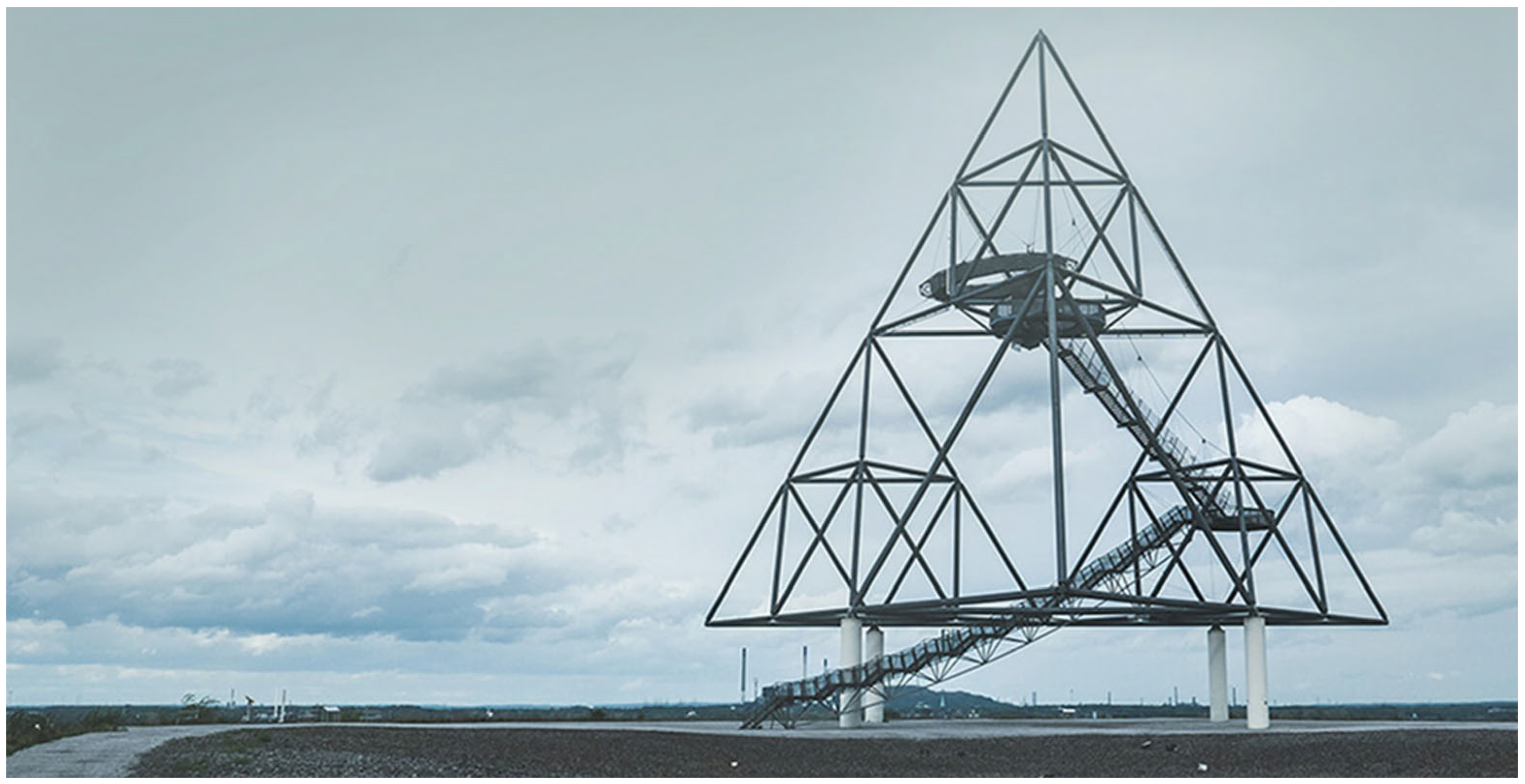
Wolfgang Christ, designer of the Tetrahedron in Bottrop (Figure 4), emphasises that post-industrial mounds were already landmarks in the landscape before anything was built on them [28]. At the Beckstraße spoil heap (where the Tetrahedron is located), disposal activities ceased in 1980 (mining supervision was abolished 10 years later). The mound was clearly visible from Emscherschnellweg (the A42 motorway, running east–west, connecting the major cities of the Ruhr Area), and its summit sections were visible from Essen. These were two important arguments for the revitalisation of this area. The need to comprehend the landscape thus became the direct reason for creating a structure that would transform the spoil heap—a landmark in its own right—into a “sign of change,” attracting visitors to a place where they could understand the environmental context. It is essential to emphasise the distinction between creating a “sign of change” and planning land use changes in its surroundings. Neither the construction of the landmark nor the process of making the landscape more legible included design interventions aimed at altering the use of the adjacent areas.
The report from the aforementioned student workshops—which marked the first step toward building the Tetrahedron—concluded with the statement that the history of the landscape should not be concealed and that new projects should be exposed, thereby shaping a new aesthetic [27]. At the same time, the photographs illustrating the brochure depict the “old” objects (of heavy industry, whose regional significance was expected to decline) as functioning, rather than closed or abandoned. Images of the surroundings draw attention to smoke plumes rising from chimneys. This detail might appear contradictory to the aim of highlighting change [27]. To what extent does shaping a new aesthetic also entail acceptance of the continued operation of “old” industrial facilities? This question was not addressed in the workshop report. In the context of the landmark’s inevitable exposure of “old” and operational objects, perceiving “signs of change” solely as elements that underscore transformation is problematic.
Christ designed the spoil heap redevelopment with the awareness that the transformation of the neighbouring heavy industry would not occur quickly, and that the possibility of implementing “signs of change” depended on mining enterprises intending to continue their operations despite policies aimed at phasing out heavy industry. This is evidenced, for instance, by the fact that although the landmark’s construction was publicly funded, the land belonged to a mining companies’ association, which acted as the project’s investor.
The designer, in personal e-mail communication with the author of this paper (in March 2023), recalls that during construction, people were convinced that Ruhrkohle AG [the then-owner of the land, now RAG AG] was erecting another technical structure on the spoil heap. The idea that land accessible for years only to employees would be opened to the public—and that a mining company would carry out such a project—seemed impossible. Based on this quote, it can be concluded that although the workshop results were made public, the community either did not read them or did not believe that the ‘paper concept’ would be implemented.
The designer did not indicate what prompted the mining company to cede the spoil heap for the creation of a public space. When asked in the previously mentioned personal e-mail communication, he stated that the landowner (the mining association) had no influence on the design and was an excellent project partner, one who handed over the mountain, the landscape, the nature, and [the structure which has since opening become] an icon of change. Two aspects of this statement merit attention: the conviction of the landmark’s symbolic significance for the region’s transformation and the simultaneous emphasis on the mining association’s lack of influence on the project alongside praise for it as a partner. While the absence of direct impact is not questioned (as stated by the designer: it was absent), this quotation illustrates a recurring issue in revitalisation practice: distinguishing between the direct and indirect influence of mining companies on the implementation of revitalisation projects. The absence of direct involvement in designing does not equate to the absence of indirect influence, which may be crucial for the feasibility of such undertakings. Equally, a lack of direct engagement does not imply that industry representatives fail to take actions informed by forthcoming changes, misunderstand the objectives of the undertaken projects, or do not consider themselves part of them—suffice it to mention that they played the role of an investor in the process until 1994 (when the construction process started), so they had to at least formally accept the legally binding decisions made by the designer. They did not ignore the decisions connected with industry. Further research indicates quite the opposite. The area was taken over by the RVR (public organisation dedicated to the development and preservation of green spaces in the region) in 1994, relieving the company of any further concern for it. I am not suggesting that Christ was unaware of these issues, but rather that the alliance between designers, authorities, and industry remained discreet.
The spoil heap gained popularity immediately after opening. The areas directly adjacent to the Tetrahedron were deliberately designed as an industrial fallow. The aesthetic sensibility promoted was tied to rejecting attempts to obscure the actual image of the environment. This, however, created tensions between users’ perceptions of change and the intentions of planners and managers. An example of this tension is the plateau arrangement by Fred Fischer, made between 2004 and 2009, which can be interpreted as an attempt by users to alter the site’s aesthetic. By colour-sorting the aggregate covering the spoil heap summit, Fischer created a bas-relief entitled Alien (a pictographic depiction of extraterrestrials). This intervention met with opposition from both the Tetrahedron’s designer and the site manager. After a heated debate, Alien was dismantled, with the justification that the work was inconsistent with the project’s concept. Why, then, was preserving the industrial aesthetic deemed more critical than users’ creative input?
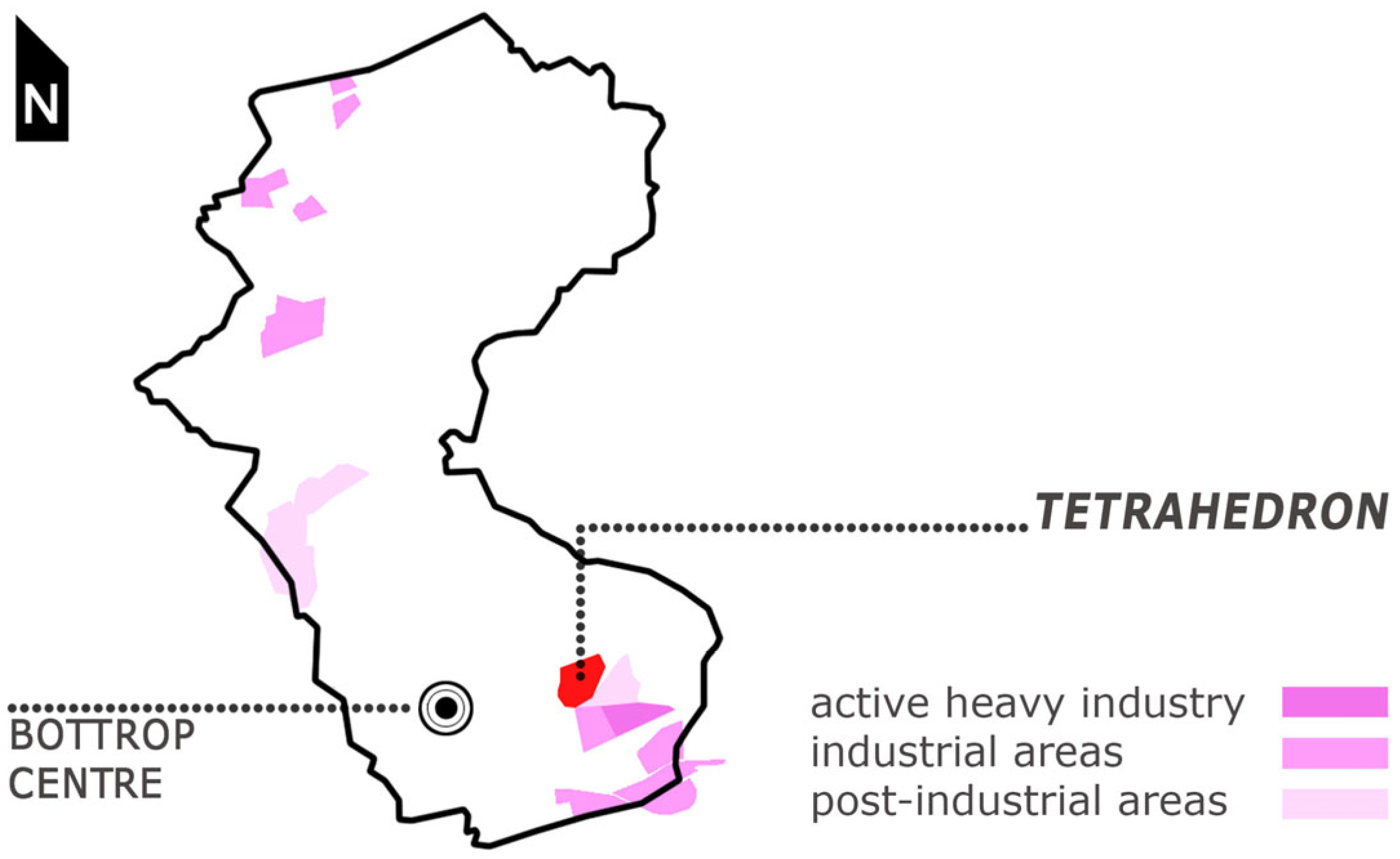
An analysis of statements from those responsible for the Ruhr Area’s revitalisation programme suggests that fostering aesthetic appreciation of the authentic industrial image was motivated by factors beyond aesthetics. The decision to leave [industrial objects] alone [38] and to promote an understanding of the industrial landscape aimed not only to preserve the region’s identity but also to reduce transformation costs. From the perspective of 30 years since its implementation, it can be stated that the construction of the “sign of change” and the conversion of the spoil heap into public space did not become a catalyst for changing the land use of the adjacent areas (Figure 5). Over time, it became clear that the neighbouring Prosper-Haniel Colliery was the longest-operating coal mine in the Ruhr Area—it closed 23 years after the analysed project’s completion (2018). To this day (2025), the Prosper coking plant operates next to it. The “signs of change” were never intended to alter the surroundings, but rather to shift perceptions of the landscape. Given that perceptions of areas with heavy industry are generally negative, the question arises: What methods were used to change these assessments, and were they successful?
To answer the question of which methods were employed, I analyse the architectural and urban design solutions. To ensure access to the summit of the greened spoil heap, with its pronounced edges, a spiral path and straight staircases were designed. Dense vegetation on the slopes creates a plinth for the landmark. At the summit, a 50 m high, open-frame tetrahedron with three platforms (at heights of 18, 32, and 38 m) was erected, accessible 24 h a day and illuminated at night, devoid of visible supervision, lacking facilities or on-site staff, and unfenced.
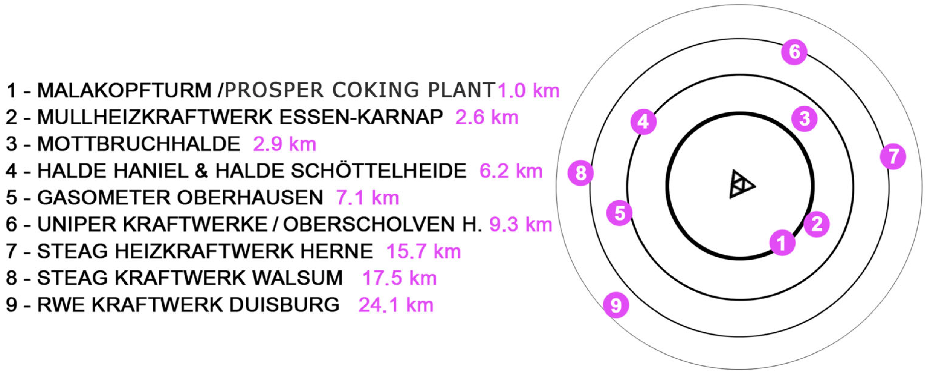
An analysis of the compositional and visual relationships reveals that the Tetrahedron was designed to make the presence of heavy industry in the environment perceptible to visitors. Its location extends the orthogonal axis separating the Prosper Colliery from the Prosper Coking Plant (Figure 6). This axis links the landmark with the dominant element of the neighbouring coking plant complex—the gas holder. The shortest climbing route to the summit of the spoil heap (direttisima—a straight stairway) aligns directly with the gate of the Prosper Colliery, and its visual termination is formed by the Essen City Hall (a high-rise building) along an axis parallel to that of the functioning heavy industry complex.
The view axes align with the main compositional axes (Figure 7), underscoring the compositional significance of the Prosper Colliery and Coking Plant (including the gas holder and spoil heap) for the landmark. The arms of the Tetrahedron’s base define a sector of space encompassing the industrial area that provided the material basis for constructing the heap and continues to function as a heavy industry site. The first observation platform opens toward this complex. The directions of the stairways suspended from the tubular structure of the landmark establish axes pointing toward the Prosper spoil heap and the Haniel spoil heap (and the Franz Haniel shaft). From the intermediate platform, the Müll-Heiz waste incineration plant (built in 1976) becomes a focal point for visitors.
The higher observation levels were designed as circular decks, providing panoramic views of the industrial landscape. In the central part of the spoil heap summit, a depression was shaped and covered with burning shale, serving as an alternative observation point from which non-industrial elements of the surroundings are concealed. This basin creates the illusion of being in an environment defined solely by prominent industrial features rising above its rim—tall, tower-like forms, chimneys, and the vapour emitted from them. From this vantage point, the exceptional nature of industrial structures becomes evident, particularly in comparison to other built elements. They are the only objects of such significant scale that they remain visible from this location. This compositional device abstracts them from their surroundings, increasing the likelihood that they will be noticed. The absence of tall vegetation at the summit ensured panoramic views encompassing all key landmarks of the Ruhr Area (Figure 8) from ground level. The pathway on the summit, linking the entrance to the direttissima stairway with the basin, terminates in a view of the Oberhausen Gasometer.
In summary, the spatial solutions emphasise the compositional and visual significance of active industrial facilities and highlight the tension between the expectation of rapid territorial change and its actual pace.

3.1.3. Case Study—Tiger & Turtle—Magic Mountain in Duisburg on a Gravel Pit Converted to a Hazardous Waste Landfill: Active Industry Transforming the Landscape

In analysing post-mining land redevelopment projects adjacent to active industrial sites in the Ruhr Area, one inevitably encounters the Tiger & Turtle—Magic Mountain project (Figure 9) and the richly illustrated publication of the same title, describing various aspects of its creation [30]. The mound—covered by a vegetated sarcophagus—was constructed between 2006 and 2008 and named Heinrich Hildebrand Heights. It is a hazardous waste deposit created following the bankruptcy of the MHD Sudamin steelworks, on the site of a former clay and gravel pit that had been filled with slag from the steelworks. The landmark built atop it (the concept of which was created as part of a widely commented competition), completed more than 15 years after the Tetrahedron, was intended as a symbol of the region’s transformation and as a means of reframing the space in users’ minds as a cultural landscape—a post-industrial landscape [30]. In this context, a paradox emerges: the revitalisation of the area was carried out at the request of residents frustrated by the burdensome activity of industry, but the construction of the structure is designed to make visitors aware of the continued presence of heavy industry in the vicinity and persuade them that such industry belongs to the past and that the landscape should be understood as post-industrial (rather than industrial).
As in the previous case, the landmark did not become a catalyst for changes in adjacent land use—a power plant, a steelworks, and a large logistics centre remain nearby.
The previously mentioned book [30] contains only a few photographs (seven) that reveal the presence of industry in the surroundings, without analysing their significance for the project. Ulrich Genth, one of the landmark’s designers, merely states that the Magic Mountain was built in an area shaped by the history of heavy industry [30] (p. 121), omitting the fact that the site is, in fact, an industrial landscape (Figure 10). Of particular interest is the photograph in the book that most vividly illustrates the industry’s nuisances (smog in the background of the landmark), which was placed alongside the list of sponsors, most of which are heavy industry enterprises operating in the vicinity. Evidently, there was no attempt to conceal the negative aspects of such activities. The neighbouring Hüttenwerke Krupp Mannesmann (HKM), Vallourec & Mannesmann Tubes, Grillo-Werke Voigt & Schweitzer, and GSI were also companies that supported the project by supplying materials and assembling the structure.
The landmark’s form is most often associated with a roller coaster from amusement parks and, according to its designers, was intended to symbolise the contrast between the illusion of rapid change (the view of the form from afar) and the reality observed up close by local residents. Admittedly, the object’s concept accurately reflects an understanding of landscape change. In direct contact, Tiger & Turtle—Magic Mountain reveals itself to be a structure composed of steep staircases, to be climbed slowly and carefully, with barriers—imperceptible from a distance—that prevent users from accessing the higher sections of the structure.
What other methods were used in translating this concept into spatial solutions for the landmark and its surroundings? The former gravel pit forms a homogeneous expanse of greenery, which again serves as a plinth for the landmark, accessible at all times, illuminated, unsupervised, and lacking facilities. A spiral path leads to the summit. The project’s composition is highly rigorous (Figure 11).
The site of the landmark is defined by the intersection of two orthogonal axes: one running from the blast furnace of the operating Krupp Mannesmann steelworks, the other from the former Rheinhausen steelworks (now the LogPort II logistics centre). The form of the mound reinforces these axes—the spoil heap ridges precisely align with these lines. Low greenery planted between the axes integrates the space occupied by the operating power plant and the LogPort I logistics centre into the composition. The view from the path leading to the summit terminates with the power plant (Figure 12). The landmark’s form frames the complexes of active industry visible in the landscape, and the entrance is positioned to focus visitors’ attention on the power plant and the LogPort I complex. The placement of small-scale architectural elements and openings in the vegetation further highlights secondary industrial structures (e.g., a wastewater treatment plant).
In summary, this project was financed mainly by public funds (see Table 1), located even closer to active industrial areas than the Tetrahedron, and through its compositional and visual arrangements, draws visitors’ attention to the fact that industry remains the driving force behind both territorial change and revitalisation and neighbouring companies supported investment, highlighting their industrial operations.

3.1.4. Understanding the Landscape in Germany

An analysis of the visual and compositional linkages in the completed projects demonstrates that the landmarks were deliberately designed to emphasise the visibility of active industrial facilities in their vicinity. In turn, an examination of visitor opinions reveals intriguing patterns. It should be emphasised once again that further results should be treated as “intriguing patterns” due to the small sample size of the surveys, and not as general conclusions.
Visibility, recommendations from previous visitors, and the media popularity of the “sign of change” were most frequently cited as motivations for visiting the site (Figure 13).
Although the surrounding areas continue to be used by heavy industry—bringing with it nuisances such as hazardous waste generation and smog—most Tetrahedron and Tiger & Turtle—Magic Mountain visitors consider the industrial surroundings attractive or quite attractive (Figure 14) and regard a visit as worthwhile and justified (Figure 15).
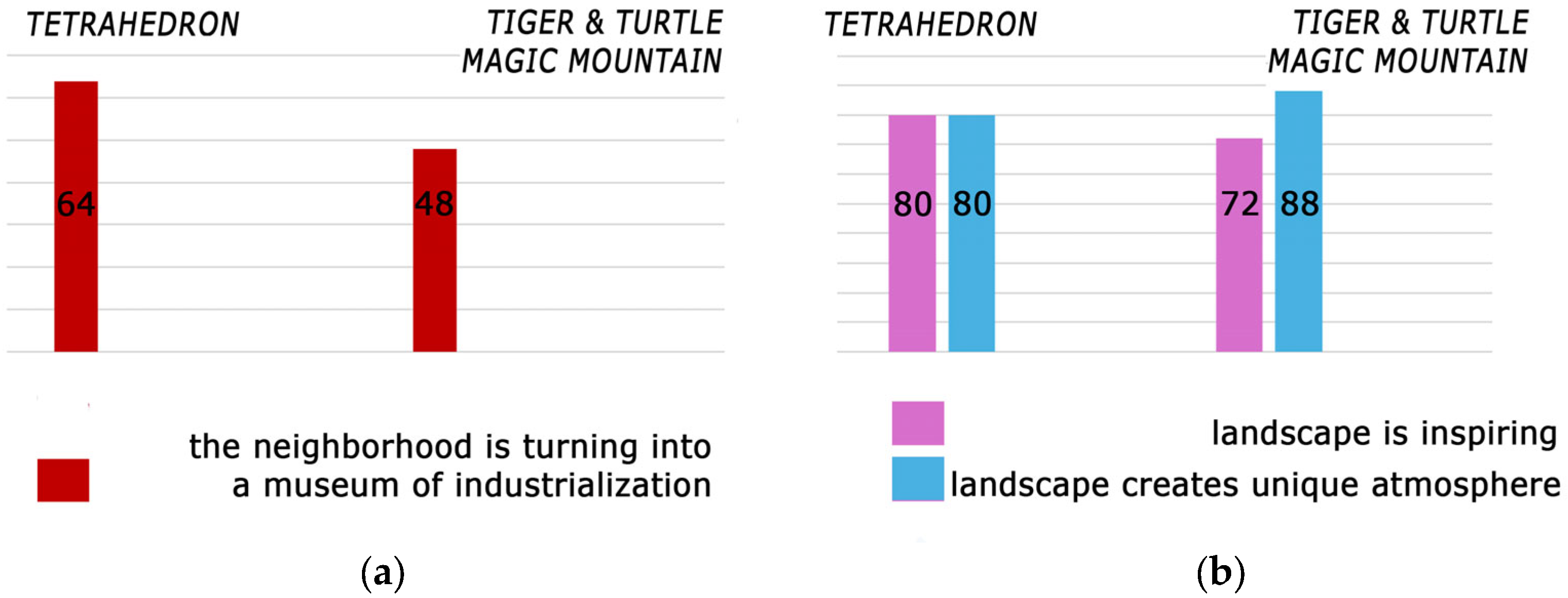
While such projects can be seen as an assumption of public responsibility for degraded land on the part of enterprises, landmarks generate no direct profits, and their funding has come from public sources. Nevertheless, users do not view them as a waste of money (Figure 16a) and the majority see them as beneficial to the community (Figure 16b).
Furthermore, in line with the designers’ intentions—but not with the factual status—visitors perceive active industrial facilities as heritage before they have been closed, subjected to conservation measures, or revitalised. They are regarded as heritage before they have actually become so (Figure 17a). Within the scope of revitalisation, the implemented spatial solutions have altered not the physical landscape, but rather its perception by users. Survey results show that the overall perception of the landscape is predominantly positive (Figure 17b), despite the continued functioning of heavy industry within it.

3.2. Public Spaces Adjacent to Industry in Poland

3.2.1. Polish “Signs of Change”

Public spaces equipped with “signs of change,” albeit with less monumental landmarks, have also been designed for areas associated with active heavy industry in Poland. The spatial solutions employed in the Ruhr Area have been deliberately adapted to achieve an effect analogous to that observed in Germany.

3.2.2. Bobrowisko Nature Enclave—Industry Creates an Attractive Landscape

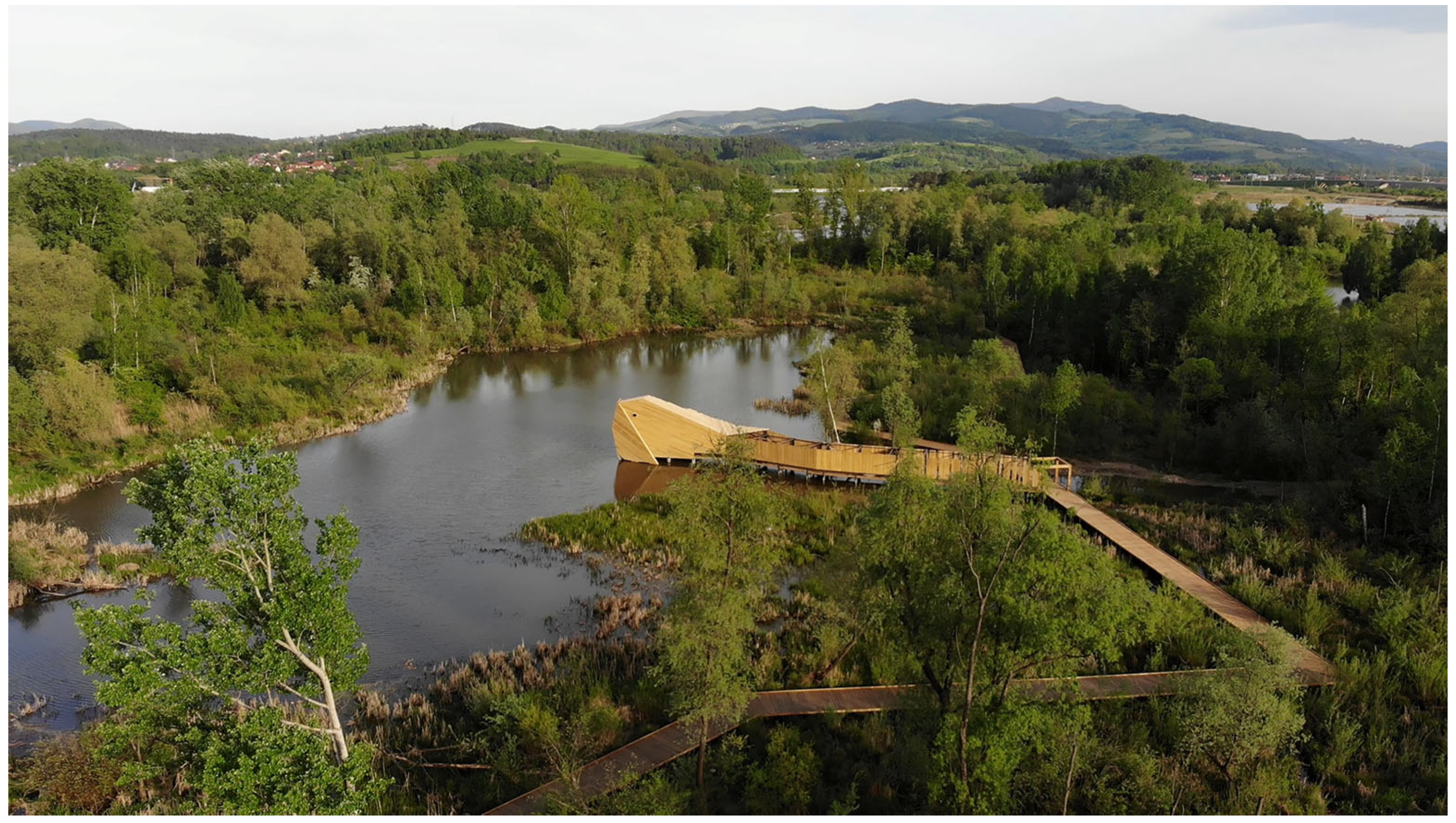
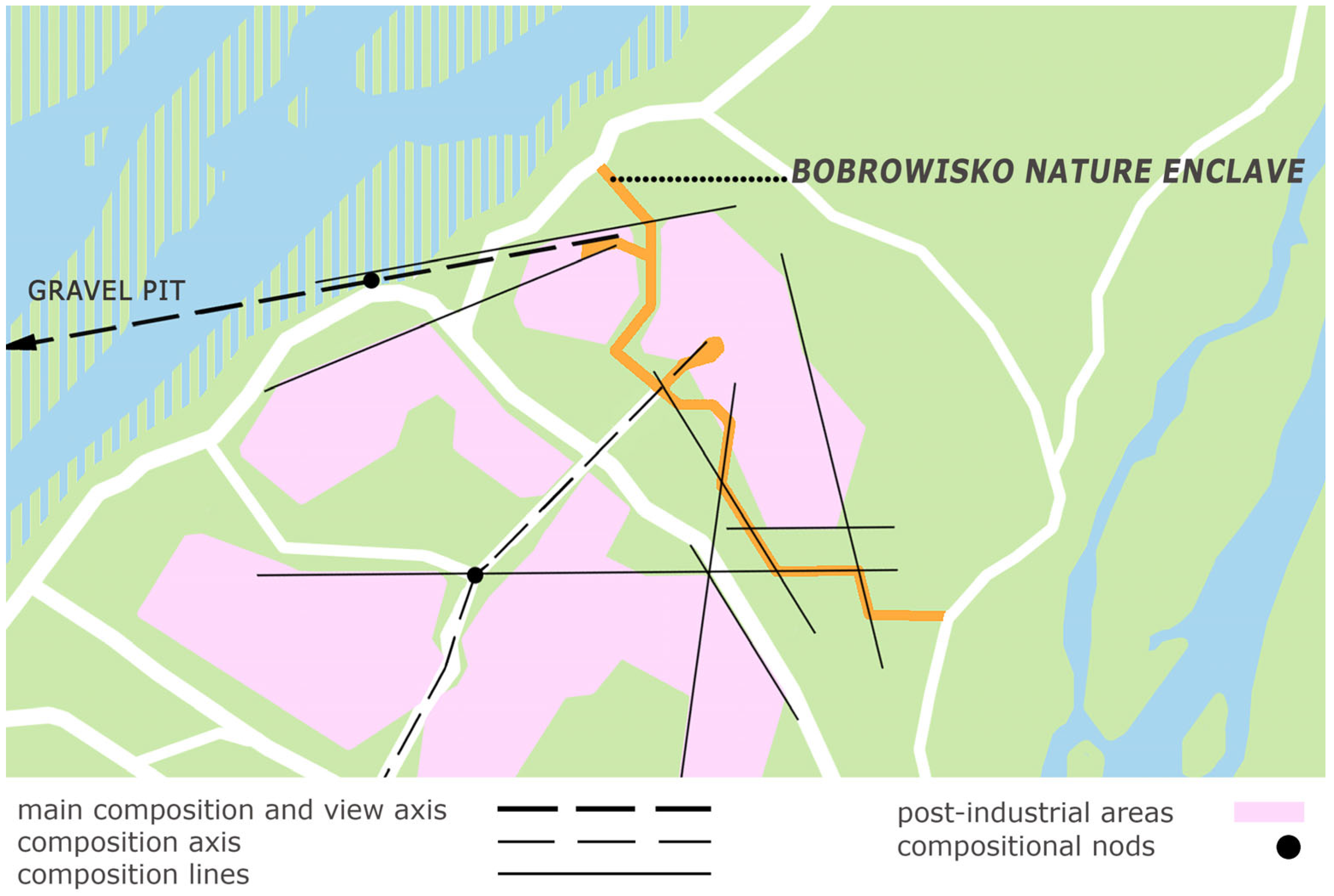
The Bobrowisko Nature Enclave project was developed for land abandoned by a gravel pit on the outskirts of the town of Stary Sącz (Figure 18), in the vicinity of actively exploited areas (Figure 19). The site was unknown to the broader public (used only by anglers). The immediate impetus for the project was the availability of external funding for biodiversity protection through wildlife observation. The investment received co-financing from the EU Regional Operational Programme of the Małopolska Voivodeship [40].
Following the first site visit in May 2015 by representatives of the 55Architekci design studio, local authorities, and nature protection services, discussions began regarding the site’s future. A series of sketches, informal meetings, and presentations led to the abandonment of plans to distance the project from the site’s industrial history or to alter the character of the landscape interior shaped by mining and transformed by natural succession. Equally significant in these discussions was convincing the authorities that the site’s development should not take the form of a traditional educational nature trail based on the installation of information boards. The designers argued that such a solution would divert attention from the site’s history and physiognomy, thereby restricting the interpretive freedom of visitors (according to unpublished meeting note No. 01/05/2015, in Polish, archived by 55Architekci). The significance and value of the site were emphasised by 55Architekci through its contrast with reclaimed areas, which involved tree planting, earthworks, and informational boards—illustrated in a satirical collage prepared for one of the working meetings (according to unpublished meeting note No. 02/05/2015, in Polish, archived by 55Architekci). The main premises of the alternative concept (as opposed to the educational trail) became: enabling individual experience and interpretation of the place by visitors; preserving the post-industrial space without interference in its form or in the changes resulting from natural processes; and adapting the area for public use through minimal architectural interventions (according to the previously mentioned meeting note No. 01/05/2025).
Based on these premises, the first design concept was prepared in October 2015 (unpublished documentation, in Polish, titled: Design Concept of a Pedestrian Footbridge—a Nature Trail with Two Observation Structures, Located at the Fork of the Poprad and Dunajec Rivers on plot 2/5 in Stary Sącz, 2015), preceded by an inventory of habitats created by industrial activity and those resulting from natural succession after mining ceased. The concept proposed that all ecologically significant sites and traces of industry should be highlighted without altering the quarry’s parameters, by constructing a walkway directing visitors’ views toward selected fragments of the space.
The next stage was the preparation of the functional–utility programme (FUP; unpublished documentation, in Polish, titled: Functional and Utility Program for the Footbridge Project—Nature Trail with Two Observation Structures, 2015), which provided guidelines for using the terrain shaped directly by industrial processes to create a peripheral public space. The FUP proposed an arrangement that met the funding programme’s objectives (biodiversity protection through wildlife observation) while preserving the quarry in its unaltered form. The document included (non-mandatory) visualisations of two birdwatching hides and a broken-line walkway using embankments between extraction fields. These visualisations convinced decision-makers to abandon the initial plan for a conventional educational trail. The visualisations were publicly presented and met with mixed reviews [41]—which is worth emphasising given the widespread appreciation for the completed project. These opinions did not dissuade the authorities from developing the project.
Based on the FUP, 55Architekci prepared the construction design in 2016. Unlike in the Ruhr Area examples, where active industry is emphasised in the landscape, the design strategy here focused on defending the industrial landscape interior as a place for individual environmental interpretation. The investment was intended to contribute to the debate on the creation of new extraction sites in the region. Without imposing interpretation, it was meant to allow visitors to discover for themselves that, post-extraction, the area is more diverse than the surrounding unaltered lands and offers aesthetic experiences impossible to achieve (or design) without mining. Using urban design tools, the walkway alignment was designed to emphasise closures, openings, and view corridors drawing attention to the variability of a landscape created by mining and subsequently modified by natural forces (Figure 20).
Fully aware of German precedents, 55Architekci deliberately sought agreement with local authorities to link extractive activities with the creation of places that allow for an individual experience of industrial culture [42]. The peripheral public space was intended to convince visitors that the aesthetics of such areas diverge sharply from the notion that “there is nothing there” in industrial landscapes. No works qualifying as technical or ecological reclamation were carried out (neither previously nor during the implementation of the enclave). The design team (W. Świątek, A. Szewczyk-Świątek, M. Caban) created minimal infrastructure enabling movement through the site—two hides and a 400-metre walkway. The significance of active industry, so prominent in the German projects, was here replaced by an emphasis on rewilded nature that had reclaimed the site without human assistance, casting doubt on the necessity of any interventions intended to “help” it.
During the opening of the investment, Leszek Zegzda, a member of the Małopolska regional board, described Bobrowisko as “sexy”—a statement widely echoed in the media (e.g., [43]). The slogan referenced the phrase popularised by the Mayor of Berlin (Berlin is poor but sexy), promoting creative, low-cost interventions as key elements of urban and economic development. The project’s popularity among visitors, and the investments it attracted within six years of its completion—a linear park, a bathing area with a holiday village, and a conference and banquet centre—confirm this observation. In 2019, the Association of Polish Architects awarded Bobrowisko the title of the best public space completed this year in Poland, highlighting its intimacy and “perfect integration into the surroundings of the former gravel pit” [44]. The project thus legitimised the possibility of reconciling industrial and architectural interests in creating a place on land neither technically nor ecologically reclaimed, but merely left fallow for 25 years.

3.2.3. Stone Park in Rożnów (Gródek n/Dunajcem Commune)—Industry Actively Creates an Attractive Landscape

The revitalisation of a disused section of the Rożnów gravel pit was designed by the same team (55Architekci; Figure 21). The site is also located on the periphery of urbanised areas. The success of the Bobrowisko Nature Enclave [45] and local residents’ protests against ongoing extraction prompted the municipal authorities of Gródek nad Dunajcem to implement a public space—Stone Park —on this site.
According to 55Architekci’s notes, the starting point for the concept was the assumption that the presence of industry should not be concealed (according to unpublished meeting note No. 05/09/2024, in Polish, archived by 55Architekci). Both the authorities and the designers were aware that mining would continue for many years in the immediate vicinity of the planned project (Figure 22). The extraction licence for the currently exploited deposit expires in 2032 [46]. The operating company (Dunajec Sp. z o.o.) is a municipal budgetary unit [47], linking the enterprise and public authorities directly. This enables a more in-depth examination of how revitalisation measures can be integrated with mining needs in spatial planning.
As in the previous example, 55Architekci sought to link industrial space with public recreational space. Through drawings and presentations, they aimed to convince the authorities that industrial activity should under no circumstances be visually obscured. The alternative plan (in contrast to the initial municipal assumption that industry should be partially hidden) was developed on the premise that the aesthetic integration of these two land uses would reduce costs and draw visitors’ attention to them as elements of the contemporary landscape. The project concept centred on small architectural interventions—rain shelters, sculptures, rest areas, viewpoints, and a promenade—designed to present stone as the initiator of life-forming processes on Earth (referencing the scientific theory that a cosmic body, the S2 meteorite, triggered the flourishing of life on our planet [48]). This symbolic presentation of stone as a life-giving element is one of the strategies intended to shift perceptions of extractive areas as “lifeless” spaces.
The layout and visual linkages emphasise the presence of active extraction in the vicinity—architectural elements frame views of machinery and the pit (Figure 23), while industrial structures close perspective lines. The arrangement of circulation routes and the construction of landmarks draw attention to the spatial use cycle. Mining activity thus becomes a defining feature distinguishing the project from other revitalised spaces.
Media communications subtly reveal the dual role of public authorities in striking a balance between economic and social interests. Visualisations of the project depict solitary visitors contemplating the landscape alongside operating excavators, accompanied by statements from Jarosław Baziak, the municipal mayor, assuring that the active section of the gravel pit will not disrupt recreation in the new park [49] and that the site will serve as both a tourist attraction and a leisure and recreation zone for residents in a quiet area [50]. The project concept convinced the authorities that integration of these spaces was possible. The images created by 55Architekci served as a keystone, aligning interests and expectations. Their exposure to public critique made it possible to invite a wider audience into the discussion on the site’s and its surroundings’ future.

3.2.4. “Understanding the Landscape” in Poland

An examination of the Polish projects shows that, similarly to the German examples, they were designed with consideration for the presence of active industrial operations in their vicinity. Both projects enjoy significant public interest. The Bobrowisko Nature Enclave has been reviewed over 1200 times on Google, with a high average rating (4.5/5). Articles and posts about the Stone Park project have attracted dozens of supportive comments (e.g., [51]). Although industry and its traces are visible in both projects, users do not identify them as nuisances. It can be observed that architectural solutions, despite their small scale, follow the same intriguing pattern (as mentioned in the German cases) of influencing the perception of both the site and the underlying issue. However, in this context, it is important to emphasise the limitations of inferences based solely on comments posted on social media, which do not fully reflect the spectrum of opinions, nor do they allow for an assessment of the real impact of architectural and urban solutions on these opinions. Therefore, as of 2025, industry in the vicinity continues to operate without change, and entrepreneurs do not face public protests against their activities—even though, following the implementation of the projects, industrial operations have become more visible than they were before the creation of the analysed public spaces.
The idea of voluntarily taking into account social and environmental interests within a company’s operations is the foundation of the concept of Corporate Social Responsibility (CSR). However, while the literature extensively examines initiatives highlighting the leading role of enterprises—which can, through their actions and projects, influence public perceptions of their operations (e.g., [52,53,54])—the role of public entities in implementing projects that consider public perceptions of industry and seek to manage them remains insufficiently explored. In the analysed cases, the promotion by local governments of the possibility of sharing the same territory between industry and recreation reflects a deliberate effort to shape attitudes favourable to extraction activities, which provide revenues to local budgets. In other words, investment in public space sheds light on the connection between the business responsibility of community representatives and spatial solutions.

4. Discussion

The study aimed to draw conclusions regarding the opportunities and risks associated with creating “signs of change” and to determine the purpose and principles of developing public spaces in non-urbanised areas adjacent to industry. The analysis of two German and two Polish case studies allows the conclusion that investments in the areas that defy the clear-cut division between “industrial” and “post-industrial” are implemented in direct or indirect alliances between enterprises and public authorities and are designed to make the facilities and landscapes of active industry in their vicinity visible.
Summarising the key themes revealed by the study—spatial solutions, the expectations of stakeholders involved in the creation of public spaces near heavy industry, and user opinions—the following points can be made:
  • Existing analyses of “signs of change” do not consider the influence of political decisions on spatial solutions, which leads to a limited understanding of the role they play in the sustainable transformation of areas in transition;
  • Public spaces in the vicinity of industrial areas have been designed to draw users’ attention to specific landscape features—namely, areas of active industry—and a preliminary study of public opinion reveals that visitors may be focused mainly on their aesthetic qualities;
  • Projects that emphasise the presence of nearby industry are designed as a kind of education and mediation tool between communities and industry, accommodating the real (slow) pace of change (however, their effectiveness requires further research);
  • The construction of public spaces adjacent to active industry are planned to connect social and economic interests.

4.1. “Signs of Change” and the Need for a Change in Perception

For years, post-industrial areas were regarded as requiring comprehensive transformation. Today, their opening to the public is considered a symbol of change. The revitalisation of former mining areas, through the construction of distinctive architectural structures (landmarks) enabling the observation of the landscape, has become emblematic of transformation. Monumental and spectacular in the German cases, and more modest yet distinctive in the Polish cases, such projects serve as iconic signals in space, indicating that an area once used for industrial purposes has been transformed into public space and made accessible to users. This interpretation is widespread in the literature (e.g., [30,36,37,38,39]). This article aims to demonstrate that separating the influence of politics and top-down decisions regarding the pace and direction of change prevents a comprehensive understanding of the role such projects play in the conflict-ridden and time-consuming process of transformation. It is well understood that sustainable territorial transformations in the course of transition do not entail abrupt changes and certainly not the sudden elimination of all burdensome industrial activities that continue to operate, provide employment, and generate budgetary revenues. An analysis of the composition and visual connections of spatial solutions allows for the conclusion that revitalisation projects have been planned to direct users’ attention toward industrial facilities and sites engaged in heavy industry—facilities known in advance to be unlikely to change rapidly and whose continued operation was considered desirable to ensure a sustainable transition (for example, to avoid a sudden surge in unemployment, e.g., [55]). Preliminary quantitative research and analyses of user-generated opinions on social media suggest that such design strategies should be further investigated for the possibility of translating the perception of active industrial facilities into industrial heritage. In other words, it is argued that these projects, in addition to functioning as physical “signs” in the landscape, have been built to focus users’ attention on the industrial elements of heavy industry that are intended to remain in operation despite the ongoing transformation. They are not designed to change the function of these facilities, but rather to change how they are perceived. In collected user opinions, these facilities are not described as burdensome—despite the expectation that making heavy industry more visible would elicit such views. Although the number of opinions is small, they indicate a correlation that is worth detailed verification due to its possible application significance.

4.2. Spatial Solutions for Understanding the Landscape

The development of former mining areas with landmarks has broadened the circle of users of exploited sites to include those from outside the local communities, who can perceive the changes from a distance—whether through passive exposure or through media coverage (see Figure 13). At the same time, an analysis of active exposure—comprising the composition and visual connections between architectural objects and areas of active industry—confirms that their construction was not solely intended to enhance the legibility of the landscape from the outside.
The visual impact of large-scale projects on the landscape (including industrial facilities and areas) is one of the most important issues in shaping public opinion about them. As such, several methods have been developed for landscape assessment, aiding in the selection of project locations and predicting community reactions to their construction [56]. What unites these methods is the question of the extent to which they alter the identity of the landscape. In this context, the idea of creating new points for the active viewing of industrial areas and facilities—often the most controversial elements of the landscape—may seem paradoxical. In the cases analysed here, post-industrial sites were developed in such a way that controversial industrial objects in the landscape were deliberately emphasised (see Figure 6, Figure 7, Figure 11, Figure 12, Figure 21 and Figure 23)—even though typical practice is to visually integrate such facilities into the landscape (e.g., [57]). By carefully designing observation points, compositional axes, view corridors, and foregrounds, active industrial objects are presented as aesthetically significant. The compositions employ the technique of “borrowed scenery,” referencing the tradition of classical Japanese gardens, in which distant landscape elements located outside the designed site are incorporated into the composition (e.g., [58]). Traditionally, however, the borrowed elements are considered attractive; in the analysed projects, the borrowed elements are active industrial facilities. These facilities form the visual focal points, define the main compositional axes, and are framed by landmarks and plantings. In other words, active industrial objects undergo a process of musealisation, in the sense given to the term by Agamben [59]: their monumentality or sublimity is emphasised rather than their utility, so that they cease to be perceived as functional long before they actually lose their function.
In each of the examined projects, the aim was to encourage visitors to experience the landscape to “understand” it personally. Understanding the post-industrial landscape as a form of cultural landscape is not contested in scholarly discourse. However, it is acknowledged that the concept has evolved to include increasingly vernacular images of the environment (e.g., [60]). It is also worth noting the concept’s strong historical anchoring, reflected in the classification of industrial landscapes into heritage industrial landscapes, post-industrial landscapes, and industrial tourism landscapes [61]. Until now, however, there has been no analysis of how the goal of “understanding” the landscape translates into local spatial solutions in areas where industry continues to operate. Based on the analyses presented here, the pursuit of landscape understanding by communities can be seen as a search for a method of opinion management employed by designers and transformation experts. This approach resonates with Foucault’s theory of governmentality [62], which posits that the limitation of regulation and the engagement of the governed in implementing a top-down policy plan are among the primary goals of contemporary governance. The case studies reveal a characteristic feature of such governmentality: the limitation of explicit regulation. In the analysed cases, public authorities and groups of interest (heavy industry companies) promote aesthetic sensitivity to industrial areas through the design and construction of objects in their vicinity, which users might perceive as necessary (compare Figure 16). By recognising the validity of projects that symbolise change but do not force it, users might unconsciously realise the goals of governance: they participate in incorporating degraded spaces into the urban structure, supporting construction from public funds, without questioning their purposefulness. If, as a result of building recreational areas and public spaces in the proximity of heavy industry, this industry could become more widely socially acceptable, and users begin to associate contact with industry with aesthetic experiences, rather than a nuisance (as preliminary opinion surveys indicate) this would have enormous application significance. The projects do not impose opinions on users, but the way in which they are expected to “understand” the landscape is nonetheless curated (cf. the earlier-discussed case of Fisher’s attempt to alter the surroundings of the Tetrahedron). By challenging the traditional division between what is made visible and what is hidden in the environmental image, these projects invite users to form their own opinions about industry, while favouring an aesthetic evaluation of the industrial objects to which attention is directed.
The extent to which the design of public spaces equipped with landmarks adjacent to active industry, as described above, was consciously intended to facilitate the prolonged operation of burdensome industrial activities has never been disclosed by the German designers. In the Polish projects, this aim was present, although its implementation was approached with caution. The popularity of these sites among users suggests that they are a satisfactory response to the growing social demand for accessible places beyond heavily urbanised areas. At the same time, their high ratings may evoke ambivalent feelings: on the one hand, they bring visibility—and potential social evaluation—to previously overlooked areas outside the sphere of public attention; on the other, creating public spaces in proximity to heavy industry entails the risk of producing lower-quality spaces (e.g., those not fully reclaimed) that may be less effective in fulfilling the need for social interaction due to their peripheral locations.

4.3. Public Spaces in the Vicinity of Industry as a Tool for Education and Mediation Between Communities and Industry

In the analysed cases, the role of architectural designs is not limited to the creation of an architectural object and its surroundings. The German projects were implemented as flagship projects within a long-term program of regional structural change. The Polish projects are locally inspired revitalisations of specific areas, responding to current needs and simultaneously drawing attention to social conflicts related to over-industry. In all locations, one can observe a search for ways to mediate with stakeholders through architectural and urban planning solutions that don’t determine the final form of the space. Such efforts refer to the concept of spatial agency [63]—the search for creative spatial solutions that are not focused on constructing a structure, but on fulfilling the ethical and social mission of architecture, as well as educating and involving users in the decision-making process. The literature on the subject is replete with research on participation. However, it is noted that the methods of inclusion are limited (public hearings, opinion polls, consultations, awareness-raising workshops, door-to-door campaigns, engaging religious groups, on-site visits, etc.) and often fail to generate the expected engagement. The final decision-making process is opaque (e.g., [64]). It is worth noting that the aforementioned participation methods lead to the verbalisation of expectations. However, without presenting them in the form of a concept supported by visualisations, they remain findings detached from real space. The research suggests that publicly presenting the concept with visualisations sparks lively discussion. At the same time, only their implementation convinces users of the possibility of coexistence between industry and recreational public spaces, laying the foundation for a discussion about the pace of sustainable territorial transformation and methods of informal education in this area. In the discussed (in this paper) cases, the community is educated about the presence of industry in space (for both economic and social purposes), and user management is achieved through architectural and urban planning solutions. Importantly, these projects do not resort to populist solutions that conceal the presence of industry, nor to radical attempts to ban industrial transformations of space. They emphasise that industry can degrade space while simultaneously providing aesthetic experiences. Thus, the actions of authorities and designers take on the form of spatial agency—the capability of acting differently. They question (through design and building forms that physical legibility) the demand to advocate for or against objects of active industry in space. In other words, through spatial solutions, they educate users that both of these positions (for/against industry) are problematic today, not only politically but also aesthetically.

4.4. Social Corporate Responsibility of Community Representatives

In none of the studied cases did heavy industry enterprises oppose the creation of public spaces, suggesting that they did not perceive them as a threat to their business interests. These projects were made possible due to the coincidence of two factors: the absence of opposition from enterprises to the transformation of areas adjacent to their operations and the redundancy of these areas for the conducted activities (in each case, the investment area is an exploited area, not needed by industry). The involvement of enterprises in the creation of public spaces and landmarks did not, in any of the studied cases, directly influence spatial decisions. In the context of Corporate Social Responsibility (CSR) and its significance for implementing sustainable development principles, this is an unsatisfactory yet expected result. Researchers note that CSR has the most significant influence on the social dimension of sustainable development, which may involve expanding social infrastructure, promoting quality of life, and improving the well-being of residents in mining areas. Nevertheless, enterprises more readily engage in supporting sustainable development in environmental and technological aspects [65]. When concern for the social dimension does appear, it tends to manifest in activities related to improving communication, negotiation processes, and labour rights [66,67].
In the analysed cases, it was designers and local authorities who began to perceive the value of linking exploited areas with those still in operation. It can be inferred that they voluntarily undertook actions reflected in spatial solutions. Aware of the economic consequences of public opposition to industrial activities, they implemented anticipatory measures to neutralise such opposition. Community representatives, within the framework of their statutory activities, initiated the creation of new public spaces in non-obvious locations. In carrying out these projects, they addressed both environmental considerations and the economic interests of the industry. They invested in fostering good relations with companies, thereby creating conditions for sustainable economic and social development. Such actions may be described as the “business responsibility” of community representatives.
Although the deliberate acquisition by local governments of degraded, not fully reclaimed sites may serve specific objectives for both enterprises (e.g., reducing fiscal burdens) and municipalities (e.g., securing land for public purposes, obtaining external funding for planned investments, or regaining public authority over the direction of transformation; cf. [3,5,68]), there is still a lack of legal frameworks and objective methods for assessing their appropriateness. The study conducted for this article suggests that emphasising the aesthetic potential of industrial objects aims to influence more positive public perceptions of industry, but at the same time could also open the field for opinion manipulation and industrial colonialism. On the one hand, such approaches try to challenge the perception of industrial areas as degraded sites that require comprehensive remediation. On the other hand, they can create spatial frameworks that enable the romanticisation and affective evaluation of such areas as places whose social and economic value can coexist with minimal investment and engagement in change. This may explain why cooperation between municipalities and enterprises in spatial decision-making regarding the revitalisation of areas adjacent to industry remains discreet.

4.5. Study Limitations and Future Research

Certain limitations can be identified that may affect the findings. The surveys in Germany were conducted on a small sample of respondents in areas with a long-standing association with mining. The user opinion surveys on Polish cases are based solely on social media posts. This part of the study was aimed to provide a preliminary understanding of the affective opinions of visitors; therefore the findings in this regard should be treated as illustrative, not generalizable, until further research confirms them.
Future research should include more surveys: a larger number of cases; a broader group of respondents (including a detailed examination of the knowledge and assessments of experts, local residents, industrial employees) and a comparison of opinions between different stakeholder groups (tourists with local residents or experts’ opinions with industrial employees’ opinions); and analyses of locations where heavy industry does not have an entrenched historical presence. Repetition of the research would be valuable to verify the consistency of the results. In the analysed cases, initial opposition to industrial activity could be described as moderate. In the Polish cases, public dissatisfaction was primarily expressed through social media posts objecting to the expansion of extraction areas and through the use of formal channels of opposition. Repetition of the research in areas where public protests against heavy industry are intense is recommended. An important thread may be the study of visibility and compositional connections with the urbanised neighbourhood, taking into account numerical values (e.g., correlation study: distances of active industrial facilities and landmarks with users’ opinions) and the possibility of using digital tools (e.g., VR/AR) in the process of educating users about both landscape elements and industrial processes (e.g., [69]).
A limitation that should be emphasised here stems from the nature of the research through design method used in the analysis of the Polish cases. This method assumes the active participation of the researcher in the design process. Combining the roles of researcher and designer can influence stakeholders’ opinions and decisions. It is possible that stakeholders, aware of the dual role of the designer, may attempt to motivate their opinions more professionally, concealing some affective assessments, favouring opinions considered rational, which in other circumstances would not be so significant, influencing the decision-making process and the solutions adopted for implementation.
Another equally important research direction should explore the practice of making partially reclaimed land accessible and reducing, but not completely eliminating, environmental and health hazards. This should be particularly examined in conjunction with architectural and urban planning solutions that attempt to shape positive community attitudes toward projects that partially repair the degradation resulting from heavy industry.
In conclusion, it is worth noting that research on the impact of spatial solutions in revitalisation projects on the operation and perception of active industry is scarce. The research presented in this article is based on projects and spatial solutions that can be considered as the paradigms— frameworks for shaping the form of other projects implemented at the initial stage of the transformation process (which can function as public spaces both at the beginning of the transformation process and after its completion). It is highly probable that landmarks are not the only projects designed to emphasise the visibility of active industry in the neighborhood, and combining architectural and urban research (spatial, visual, and compositional connections) with social research can be applied to the analysis of other cases that draw attention to the presence of industry in the neighbourhood (not just landmarks) and also revitalisation enterprises based on the construction of buildings, the formation of green spaces, parks, etc. Such research defines a promising field for further analysis.

5. Conclusions: Revitalising and Maintaining Heavy Industry

This research is particularly relevant today, when securing public acceptance of industry is a key concern for both entrepreneurs and local authorities. It is equally significant in the context of managing sustainable transformations of areas where the continuation of industrial activity—or a deliberate slowing of the phase-out of negatively perceived industrial operations—is planned due to social and economic benefits. The analyses of cases show that:
  • The visual and compositional linkages in the cases demonstrate that the landmarks were deliberately designed to emphasise the visibility of active industrial facilities in their vicinity;
  • The promotion by local governments of the policy of sharing the same territory between industry and recreation reflects a deliberate effort to shape attitudes favourable to industrial activities, which provide revenues to local budgets;
  • “Signs of change” in the landscape have been built to focus users’ attention on the representation of heavy industry and intended to keep them in operation, despite the ongoing transformation—they are not designed to change the function of these facilities, but rather to change how they are perceived;
  • Revitalisation based on specific spatial solutions that emphasise the visibility of areas commonly regarded as environmentally degrading can serve to educate, maintain or secure the social legitimacy of heavy industry, including mining, either in the spirit of sustainable development or as a practice that opens the possibility of manipulating public opinion (without implementing solutions that actually aim at sustainable development);
  • Discrete alliances aimed at influencing user opinions through spatial solutions can be formed in various cultural contexts;
  • Stakeholders try to influence users’ opinions about active industries through spatial solutions, but their effectiveness requires further research.
Last but not least, this study demonstrates that we still have a limited understanding of the actions that can or should be taken to ensure that the sustainable development we strive for is of broader interest to the community, as well as to experts from various disciplines. In other words, it’s worth emphasising that architectural and urban solutions probably could play a more significant role in not only better understanding but also recognising the specifics of heavy industry operations—important to environmental, engineering and technological solutions. One of the main goals of Sustainable Development is increasing the resource efficiency [70]—this article characterises architectural and urban solutions that enable the reuse of resource extraction areas, making them popular with users. It fills a research gap by identifying physical solutions in the space that reflect efforts to efficiently manage resources. It also highlights the lack of research that provides ready-to-apply knowledge that allows for the predictable implementation of goals that align the interests of communities, public authorities, and industrial entrepreneurs—influencing user opinions in a predictable and transparent manner and strengthening the environmental, economic, and social resilience of communities.

Supplementary Materials

The following supporting information can be downloaded at: https://www.mdpi.com/article/10.3390/su17198567/s1. Figures S1–S3: Original questionnaires in German. Figures S4–S6: Original questionnaires in English, Figures S7 and S8: User opinion survey: Tetrahedron with the results; Figures S9 and S10: User opinion survey: Tiger & Turtle—Magic Mountain with the results.

Funding

This research was funded by the Initiative for Excellence—Research University at AGH University of Krakow.

Institutional Review Board Statement

This study was completed before 2023. In accordance with the provisions issued by the Ethics Committee of the Senate of the Krakow University of Technology on September 25, 2024 (§ 2 p.3) (https://bip.pk.edu.pl/index.php?ver=0&dok=4968; accessed on 28 July 2025), research applications that entered the implementation phase and were completed prior to this date are not subject to the restrictions outlined in this opinion. Therefore, it is exempt from ethical review by the Institutional Review Board.

Informed Consent Statement

Informed consent was obtained from all subjects involved in the study.

Data Availability Statement

Data is contained within the article or Supplementary Materials.

Acknowledgments

The author thanks the anonymous reviewers and academic editor for their insightful comments and suggestions.

Conflicts of Interest

The author declares that they have no conflicts of interest. The funders had no role in the design of the study; in the collection, analysis, or interpretation of data; in the writing of the manuscript; or in the decision to publish the results.

References

  1. Luger, J.; Schwarze, T. Leaving Post-industrial Urban Studies Behind? Dialogues Urban Res. 2024, 2, 188–209. [Google Scholar] [CrossRef]
  2. Mah, A. Anticipating Just Transitions. In The Routledge International Handbook of Deindustrialization Studies; Strangleman, T., Linkon, S.L., High, S., Clarke, J., Berger, S., Eds.; Routledge: London, UK, 2025; pp. 169–178. [Google Scholar]
  3. Cała, M.; Szewczyk-Świątek, A.; Ostręga, A. Challenges of Coal Mining Regions and Municipalities in the Face of Energy Transition. Energies 2021, 14, 6674. [Google Scholar] [CrossRef]
  4. Enemuo, M.; Ogunmodimu, O. Transitioning the Mining Sector: A Review of Renewable Energy Integration and Carbon Footprint Reduction Strategies. Appl. Energy 2025, 384, 125484. [Google Scholar] [CrossRef]
  5. Ostręga, A.; Szewczyk-Świątek, A.; Cała, M.; Dybeł, P. Obsolete Mining Buildings and the Circular Economy on the Example of a Coal Mine from Poland—Adaptation or Demolition and Building Anew? Sustainability 2024, 16, 7493. [Google Scholar] [CrossRef]
  6. Lanz, F.; Pendlebury, J. Adaptive Reuse: A Critical Review. J. Archit. 2022, 27, 441–462. [Google Scholar] [CrossRef]
  7. Ahac, M.; Gašparović, S.; Šmit, K. Infrastructure in Post-industrial Urban Landscapes. In The Reimagining of Urban Spaces; Applied Innovation and Technology Management; Lakušić, S., Pavičić, J., Stojčić, N., Scholten, P.W.A., van Sinderen Law, J., Eds.; Springer: Cham, Switzerland, 2024. [Google Scholar] [CrossRef]
  8. Krivý, M. Speculative redevelopment and conservation: The signifying role of architecture. City 2011, 15, 42–62. [Google Scholar] [CrossRef]
  9. Krivý, M. The Smart and the Ruined: Notes on the New Social Factory. Thresholds 2019, 47, 75–90. [Google Scholar] [CrossRef]
  10. Szewczyk-Światek, A. Architecture and Active Heavy Industry: On Initiatives Influencing the Social Perception of Industry in Light of German and Polish Experiences with the Revitalization of Mining-Related Areas. Ph.D. Thesis, Cracow University of Technology, Krakow, Poland, 2023. Available online: https://repozytorium.biblos.pk.edu.pl/resources/47693 (accessed on 2 May 2025). (In Polish).
  11. Maesham, T.; Walker, J.; McKenzie, F.H.; Kirby, J.; Williams, C.; D’Urso, J.; Littleboy, A.; Samper, A.; Rey, R.; Maybee, B.; et al. Beyond Closure: A Literature Review and Research Agenda for Post-mining Transitions. Resour. Policy 2024, 90, 104859. [Google Scholar] [CrossRef]
  12. Minister für Stadtentwicklung, Wohnen und Verkehr des Landes Nordrhein-Westfalen. Internationale Bauausstellung Emscher-Park: Werkstatt für die Zukunft alter Industriegebiete: Memorandum zu Inhalt und Organisation; Archiwum Stiftung Geschichte des Ruhrgebiets; Minister für Stadtentwicklung, Wohnen und Verkehr des Landes Nordrhein-Westfalen: Düsseldorf, Germany, 1989. [Google Scholar]
  13. Berger, S. Introduction: Memories, Memorialization, and the Heritage of Deindustrialization. In The Routledge International Handbook of Deindustrialization Studies; Strangleman, T., Linkon, S.L., High, S., Clarke, J., Berger, S., Eds.; Routledge: London, UK, 2025; pp. 363–380. [Google Scholar]
  14. Somerville, E. The Musealization of Barcelona’s Industrial Past. Ph.D. Thesis, Universitat Autònoma de Barcelona, Barcelona, Spain, 2020. Available online: https://ddd.uab.cat/pub/tesis/2021/hdl_10803_671929/edso1de1.pdf (accessed on 10 September 2025).
  15. Shaw, R. The International Building Exhibition (IBA) Emscher Park, Germany: A Model for Sustainable Restructuring? Eur. Plan. Stud. 2002, 10, 77–97. [Google Scholar] [CrossRef]
  16. Keenan, J.; Holcombe, S. Mining as a Temporary Land Use: A Global Stocktake of Postmining Transitions and Repurposing. Extr. Ind. Soc. 2021, 8, 100924. [Google Scholar] [CrossRef]
  17. Pagouni, C.; Pavloudakis, F.; Kapageridis, I.; Yiannakou, A. Transitional and Post-Mining Land Uses: A Global Review of Regulatory Frameworks, Decision-Making Criteria, and Methods. Land 2024, 13, 1051. [Google Scholar] [CrossRef]
  18. Sukopp, H. On the Early History of Urban Ecology in Europe. Preslia Praha 2002, 74, 373–393. [Google Scholar]
  19. Box, J. Nature Conservation and Post-Industrial Landscapes. Ind. Archaeol. Rev. 1999, 21, 137–146. [Google Scholar] [CrossRef]
  20. Bonincontro, T.; Cerceau, J.; Tena-Chollet, F.; Beccera, S. From Unseen to Seen in Post-Mining Polluted Territories: (In)visibilisation processes at work in soil contamination management. Humanit. Soc. Sci. Commun. 2024, 11, 785. [Google Scholar] [CrossRef]
  21. Krivý, M. Fitness Urbanism. In Proceedings of the Platform Austria, Biennale Architettura, Venice, Italy, 22 May–21 July 2021; Available online: https://www.platform-austria.org/en/blog/fitness-urbanism (accessed on 5 September 2025).
  22. Bole, D.; Kumer, P.; Gašperič, P.; Kozina, J.; Pipan, P.; Tiran, J. Clash of Two Identities: What Happens to Industrial Identity in a Post-Industrial Society? Societies 2022, 12, 49. [Google Scholar] [CrossRef]
  23. Anguelovski, I.; Connolly, J.J.T.; Cole, H.; Garcia-Lamarca, M.; Triguero-Mas, M.; Baró, F.; Martin, N.; Conesa, D.; Shokry, G.; del Pulgar, C.P.; et al. Green Gentrification in European and North American Cities. Nat. Commun. 2022, 13, 3816. [Google Scholar] [CrossRef] [PubMed]
  24. Rovira, J.; Nadal, M.; Schuhmacher, M.; Domingo, J.L. Environmental impact and human health risks of air pollutants near a large chemical/petrochemical complex: Case study in Tarragona, Spain. Sci. Total Environ. 2021, 787, 147550. [Google Scholar] [CrossRef]
  25. Onifade, M.; Adetunji Adebisi, J.; Penda Shivute, A.; Genc, B. Challenges and applications of digital technology in the mineral industry. Resour. Policy 2023, 85B, 103978. [Google Scholar] [CrossRef]
  26. Lyashenko, V.I.; Golik, V.I.; Klyuev, R.V. Evaluation of the efficiency and environmental impact (on subsoil and groundwater) of underground block leaching (UBL) of metals from ores. Min. Sci. Technol. 2022, 7, 5–17. [Google Scholar] [CrossRef]
  27. Christ, W.; Maiwurm, C.; Plum, S.; Witte, A. Haldenereignis—Emscherblick: Eine Denkschrift; Archiv UI-Institut: Bottrop, Germany, 1990. [Google Scholar]
  28. Christ, W. Haldenereignis Emschrblick Bottrop. 1994. Available online: https://www.mediastadt.com/projekte/tetraeder/tetraeder.html (accessed on 26 June 2025).
  29. Dettmar, J. Rekultivierung von Bergehalden im Ruhrgebiet: Beobachtungen und Erfahrungen. In Bergbau und Umwelt in DDR und BRD: Praktiken der Umweltpolitik und Rekultivierung; Albrecht, H., Farrenkopf, M., Eds.; De Gruyter Oldenbourg: Berlin, Germany; Boston, MA, USA, 2022; pp. 163–194. [Google Scholar] [CrossRef]
  30. Dinkla, S.; Greulich, P. (Eds.) Tiger & Turtle—Magic Mountain: A Landmark in Duisburg by Heike Mutter and Ulrich Genth; Hatje Cantz: Duisburg, MA, USA, 2012. [Google Scholar]
  31. Polish Geological Institute National Research Institute. Sand and Gravel (Natural Aggregates). 2024. Available online: https://www.pgi.gov.pl/en/mineral-resources/rock-raw-materials-and-others/sand-and-gravel-natural-aggregates.html (accessed on 27 July 2025).
  32. Agamben, G. (Ed.) What Is a Paradigm? In The Signature of All Things: On Method; Zone Books: New York, NY, USA, 2009; pp. 9–32. [Google Scholar]
  33. Lynch, K. The Image of the City, 12th ed.; The MIT Press: Cambridge, MA, USA; London, UK, 1990. [Google Scholar]
  34. Svobodova, K.; Barták, V.; Hendrychová, M. Visiting Mine Reclamation: How Field Experience Shapes Perceptions of Mining. Ambio 2025, 54, 72–85. [Google Scholar] [CrossRef]
  35. Frayling, C. Research in Art and Design. R. Coll. Arts Pap. 2014, 1, 1–5. [Google Scholar]
  36. Wicke, C. Introduction: Industrial Heritage and Regional Identities. In Industrial Heritage and Regional Identities; Wicke, C., Berger, S., Golombek, J., Eds.; Routledge: London, UK; New York, NY, USA, 2018; pp. 1–12. [Google Scholar]
  37. Weilacher, U. Rusty-brown and Phacelia Blue—Landmark Art by the IBA. Topos 1999, 26, 60–68. [Google Scholar]
  38. Fong, C. Bergbau, Tagebau, Umbau: The Post-Industrial Landscape Aesthetic of Repurposed Coal Mines in Germany. Ph.D. Thesis, University of Michigan, Ann Arbour, MI, USA, 2019. Available online: https://deepblue.lib.umich.edu/handle/2027.42/153435 (accessed on 1 August 2025).
  39. Budinger, A.; Schmitt, H.C.; Ze, M.; Karulska, O.; Wenning, T. Heap Development in the Ruhr Metropolis. The ‘Mountains of the Ruhr’ as Places of Identity. In Proceedings of the Space For Species: Redefining Spatial Justice, AESOP Annual Congress. Tartu, Estonia, 25–29 July 2022; Available online: https://proceedings.aesop-planning.eu/index.php/aesopro/issue/view/14/14 (accessed on 1 August 2025).
  40. Press Office of the Malopolska Voivodeship Marshal’s Office. The Bobrowisko in Stary Sącz is Open to Residents. 2018. Available online: https://www.malopolska.pl/aktualnosci/fundusze-europejskie/bobrowisko-w-starym-saczu-otwarte-dla-mieszkancow (accessed on 9 August 2025). (In Polish).
  41. Starosadeckie.info. PLN 1.3 Million for the Protection of Biodiversity in Stary Sącz. 2016. Available online: https://www.starosadeckie.info/wydarzenia/13-mln-zl-ochrone-bioroznorodnosci-starym-saczu/ (accessed on 13 August 2025). (In Polish).
  42. Świątek, W. The Role of the Objects of Cultural Expression in Defining Significant Places in the Landscape. Ph.D. Thesis, Cracow University of Technology, Krakow, Poland, 2021. Available online: https://repozytorium.biblos.pk.edu.pl/resources/44846 (accessed on 9 August 2025). (In Polish).
  43. Sądeczanin.info. The Bobrowisko Enclave in Stary Sącz is Simply Sexy! 2018. Available online: https://sadeczanin.info/wiadomosci/enklawa-bobrowisko-w-starym-saczu-jest-po-prostu-sexy-wideo (accessed on 9 August 2025). (In Polish).
  44. The Association of Polish Architects (Stowarzyszenie Architektów Polskich, SARP). Competition SARP Award of the Year, 2019 Edition. 2019. Available online: https://www.sarp.pl/pokaz/konkurs_nagroda_roku_sarp-_edycja_2019,2719/ (accessed on 9 August 2025). (In Polish).
  45. Gazeta Krakowska. A New Attraction is to Be Built at Lake Rożnów, Inspired by the Famous Bobrowisko: An Old Gravel Pit Will Be Transformed into a Spectacular Park. 2025. Available online: https://gazetakrakowska.pl/nad-jeziorem-roznowskim-ma-powstac-nowa-atrakcja-inspiracja-slynne-bobrowisko-stara-zwirownia-zamieni-sie-w-zjawiskowy-park/ar/c1p2-27334523 (accessed on 10 August 2025). (In Polish).
  46. Dunajec Wodociągi. Gravel Pit General Information. 2025. Available online: https://dunajec-grodek.pl/Informacje-ogolne (accessed on 9 August 2025). (In Polish).
  47. Rejestr.io Wyszukiwarka danych z KRS. Dunajec. 2025. Available online: https://rejestr.io/krs/282163/dunajec (accessed on 9 August 2025). (In Polish).
  48. Drabon, N.; Knoll, A.H.; Lowe, R.; Bernasconi, S.M.; Brenner, A.R.; Mucciarone, D.A. Effect of a Giant Meteorite Impact on Paleoarchean Surface Environments and Life. Proc. Natl. Acad. Sci. USA 2024, 121, e2408721121. [Google Scholar] [CrossRef] [PubMed]
  49. Radio Krakow. Former Gravel Pit, There Will Be a New Attraction at Lake Rożnów. 2025. Available online: https://www.radiokrakow.pl/aktualnosci/nowy-sacz/byla-zwirownia-bedzie-nowa-atrakcja-nad-jeziorem-roznowskim/ (accessed on 10 August 2025). (In Polish).
  50. Dts24. News from Sądeczyzna Region. A Quiet Space for Strolling: Stone is the Main Motif of the Relaxation Zone in Rożnów. 2025. Available online: https://www.dts24.pl/cicha-przestrzen-do-spacerow-kamien-motywem-przewodnim-strefy-relaksu-w-roznowie/ (accessed on 10 August 2025). (In Polish).
  51. Facebook. Jarosław Baziak Mayor of Grodek on Dunajec Comune Profile. 2025. Available online: https://www.facebook.com/jaroslawbaziak/posts/122199293222133158?ref=embed_post (accessed on 10 August 2025).
  52. Fraser, J. Mining companies and communities: Collaborative approaches to reduce social risk and advance sustainable development. Resour. Policy 2021, 74, 101144. [Google Scholar] [CrossRef]
  53. Gudrun, F.; Schütte, P. Current trends in addressing environmental and social risks in mining and mineral supply chains by regulatory and voluntary approaches. Miner. Econ. 2022, 35, 653–671. [Google Scholar] [CrossRef]
  54. Bansal, S.; Singh, S.; Nangia, P.; Chanaliya, N.; Sala, D. Sustaining the mining industry through the lens of corporate social responsibility: A review research. Resour. Policy 2024, 99, 105387. [Google Scholar] [CrossRef]
  55. Ganser, K. Eine Baustellungim in Hübsch-Hässlicher Umgebung. Forum Ind. Geschichtskultur 2009, 1, 19. [Google Scholar]
  56. Palmer, J.F. A Diversity of Approaches to Visual Impact Assessment. Land 2022, 11, 1006. [Google Scholar] [CrossRef]
  57. Dentoni, V.; Lai, A.; Pina, F.; Cigagna, M.; Massacci, G.; Grosso, B. A Comprehensive Methodology for the Visual Impact Assessment of Mines and Quarries. Environ. Impact Assess. Rev. 2023, 102, 107199. [Google Scholar] [CrossRef]
  58. Schwazer, R.H. Borrowed Sceneries; Birkhäuser: Basel, Switzerland, 2024. [Google Scholar]
  59. Agamben, G. Pochwała profanacji (en. In Praise of Profanation). In Profanacje (en. Profanations); Agamben, G., Ed.; PIW: Warszawa, Poland, 2005; pp. 93–116. [Google Scholar]
  60. Höfer, W.; Vicenzotti, V. Post-industrial Landscapes: Evolving Concepts. In The Routledge Companion to Landscape Studies, 2nd ed.; Howard, P., Thompson, I., Waterton, E., Atha, M., Eds.; Routledge: London, UK, 2018; pp. 499–510. [Google Scholar]
  61. Zhang, J.; Cenci, J.; Becue, V. A Preliminary Study on Industrial Landscape Planning and Spatial Layout in Belgium. Heritage 2021, 4, 1375–1387. [Google Scholar] [CrossRef]
  62. Foucault, M. Narodziny Biopolityki (en. The Birth of Biopolitics); PWN: Warszawa, Poland, 2011. [Google Scholar]
  63. Awan, N.; Schneider, T.; Till, J. Spatial Agency: Other Ways of Doing Architecture; Routledge: Oxon, UK, 2011. [Google Scholar]
  64. Grodach, C.; Hatuka, T.; Ferm, J.; Danan Vincent, A.; Merve Nalçakar, E.; Çalışkan, O.; Chang, R.A. Industrial Lands and Development. Plan. Theory Pract. 2024, 25, 699–727. [Google Scholar] [CrossRef]
  65. Pouresmaieli, M.; Ataei, M.; Qarahasanlou, A.N.; Barabadi, A. Corporate Social Responsibility in Complex Systems Based on Sustainable Development. Resour. Policy 2024, 90, 104818. [Google Scholar] [CrossRef]
  66. Yang, Y.; Chen, D. Issues of Corporate Social Responsibility in the Mining Industry: The Case of China. Resour. Policy 2022, 76, 102648. [Google Scholar] [CrossRef]
  67. Pons, A.; Vintrò, C.; Josep Rius, J.; Jordi Vilaplana, J. Impact of Corporate Social Responsibility in mining industries. Resour. Policy 2021, 72, 102117. [Google Scholar] [CrossRef]
  68. Szewczyk-Świątek, A.; Ostręga, A.; Cała, M.; Beese-Vasbender, P. Utilizing Circular Economy Policies to Maintain and Transform Mining Facilities: A Case Study of Brzeszcze, Poland. Resources 2024, 13, 112. [Google Scholar] [CrossRef]
  69. Fernández-Moyano, J.A.; Remolar, I.; Gómez-Cambronero, Á. Augmented Reality’s Impact in Industry—A Scoping Review. Appl. Sci. 2025, 15, 2415. [Google Scholar] [CrossRef]
  70. UN. The Sustainable Development Goals Report 2025; UNSD: New York, NY, USA, 2025; Available online: https://unstats.un.org/sdgs/report/2025/The-Sustainable-Development-Goals-Report-2025.pdf (accessed on 19 September 2025).
Figure 1. Landscape of the Ruhr area with operating heavy industry, about 30 years after the start of the revitalisation process, 2022 (source: own photo).
Sustainability 17 08567 g001
Figure 2. Localisation of Tetrahedron and Tiger & Turtle—Magic Mountain in the Ruhr area, 2025 (source: own study).
Sustainability 17 08567 g002
Figure 3. Localisation of Bobrowisko Nature Enclave and Stone Park in Rożnów (Gródek n/Dunajcem Commune) in Lesser Poland Voivodeship, 2025 (source: own study).
Sustainability 17 08567 g003
Figure 4. Tetrahedron in Bottrop was built on a spoil heap against an industrial background, 2015 (source: own photo).
Sustainability 17 08567 g004
Figure 5. Beckstraße spoil heap and land use in adjacent areas, 2025 (source: own study, based on [10]).
Sustainability 17 08567 g005
Figure 6. Compositional layout of Beckstraße spoil heap (orange), 2025 (source: own study, based on [10]).
Sustainability 17 08567 g006
Figure 7. Visual linkages between Beckstraße spoil heap and surrounding industrial facilities, 2025 (source: own study, based on [10]).
Sustainability 17 08567 g007
Figure 8. Active exposure of industrial facilities from the Beckstraße spoil heap, 2025 (source: own study, based on [10]).
Sustainability 17 08567 g008
Figure 9. Tiger & Turtle—Magic Mountain in Duisburg built on the top of a hazardous waste landfill in a former gravel pit against an industrial background (left), 2024 (source: own photo).
Sustainability 17 08567 g009
Figure 10. Heinrich Hildebrand Heights and adjacent land use, 2025 (source: own study, based on [10]).
Sustainability 17 08567 g010
Figure 11. Compositional layout of Heinrich Hildebrand Heights (HHH; orange) showing connections with neighbouring industrial areas, 2025 (source: own study, based on [10]).
Sustainability 17 08567 g011
Figure 12. Visual linkages between Heinrich Hildebrand Heights and surrounding industrial facilities, 2025 (source: own study, based on [10]).
Sustainability 17 08567 g012
Figure 13. Inspiration to visit Tetrahedron and Tiger & Turtle Magic Mountain—users answers, 2025 (source: own study, based on [10]; compare with Figures S7 and S9, questions A5).
Sustainability 17 08567 g013
Figure 14. Users’ opinions about the industrial landscape, 2025 (source: own study, based on [10]; compare with Figures S7 and S9, question A6).
Sustainability 17 08567 g014
Figure 15. Users’ opinions about post-industrial place, 2025 (source: own study, based on [10]; compare with Figures S7 and S9, question B2d).
Sustainability 17 08567 g015
Figure 16. Visitors’ opinions about investments: (a) Profitability; (b) beneficiality, 2025 (source: own study, based on [10]; compare with Figures S7 and S9, questions B6e and B1a).
Sustainability 17 08567 g016
Figure 17. Visitors’ opinions about: (a) direction of changes of neighbourhood, 2025 (source: own study, compare with Figures S8 and S10, question C6b); (b) industrial landscape (source: own study, based on [10]; compare with Figures S8 and S10, questions D1a and D1c).
Sustainability 17 08567 g017
Figure 18. Bobrowisko Nature Enclave against an industry background (in the top right corner of the photograph), 2018. Reproduced with permission from Dariusz Ptak (2025).
Sustainability 17 08567 g018
Figure 19. Bobrowisko Nature Enclave and adjacent land use, 2025 (source: own study).
Sustainability 17 08567 g019
Figure 20. Compositional layout and visual linkages between Bobrowisko Natural Enclave (orange) and areas of active exploitation, 2025 (source: own study).
Sustainability 17 08567 g020
Figure 21. Stone Park in Rożnów against an industrial backdrop (Gródek nad Dunajcem Commune), 2025. Reproduced with permission from 55Architekci (2025).
Sustainability 17 08567 g021
Figure 22. Stone Park in Rożnów and adjacent land use, 2025 (source: own study).
Sustainability 17 08567 g022
Figure 23. Compositional layout and visual linkages between Stone Park in Rożnów (orange) and areas of active exploitation, 2025 (source: own study).
Sustainability 17 08567 g023
Table 1. Main characteristics of the analysed cases.
Name of Case Study
(Country)
Tetrahedron
(DE)
Tiger & Turtle—Magic Mountain (DE)Bobrowisko Nature Enclave (PL)Stone Park (PL)
Size40 ha12.3 ha3.5 ha8 ha
BudgetEUR 1.2 MEUR 2 MEUR 0.36 MEUR 1.06 M
FundingEUR 1.1 M
regional ecological programme
+
EUR 0.1 M
the municipality’s own funds
EUR 1.8 M
regional funds and
regional ecological programme
+
EUR 0.2 M
European Capital of Culture Fund and sponsors
EUR 0.31 M
regional funds
+
EUR 0.05 M
the municipality’s own funds
Not disclosed
Year1995201120182025
Social
effects
Meeting and view point with the public space in the formerly degraded areaMeeting and view point with the public space in the formerly degraded areaLookout and the public space in the formerly isolated areaLookout points and the public space in the formerly excluded area
Environmental effectsReclamation of the spoil heapReclamation of gravel pit and slag heap (hazardous waste landfill)Conservation of natural succession in the former gravel pit areaRevitalisation of the gravel pit
Disclaimer/Publisher’s Note: The statements, opinions and data contained in all publications are solely those of the individual author(s) and contributor(s) and not of MDPI and/or the editor(s). MDPI and/or the editor(s) disclaim responsibility for any injury to people or property resulting from any ideas, methods, instructions or products referred to in the content.