Integrating InVEST and MaxEnt Models for Ecosystem Service Network Optimization in Island Cities: Evidence from Pingtan Island, China
Abstract
1. Introduction
2. Literature Review and Research Gaps
3. Methodology
3.1. Research Framework
3.2. Study Area
3.3. Assessment of the Quantity of Ecosystem Service Functions
3.3.1. Habitat Quality Modeling
3.3.2. Soil Conservation Modeling
3.3.3. Water Supply Model
3.3.4. Carbon Stock Modeling
3.3.5. Cultural Ecosystem Services (CESs)
3.4. CESI Construction
3.5. Ecological Source Identification and Resistance Factor Selection
3.6. Construction of Ecosystem Services Network (ESN) Based on MCR Modeling
3.7. Identification of Ecological Pinchpoints and Barriers
3.8. Determination of Optimal Width of ESN and Current Density Simulation
4. Results
4.1. Results of the Quantification of Ecosystem Service Functions
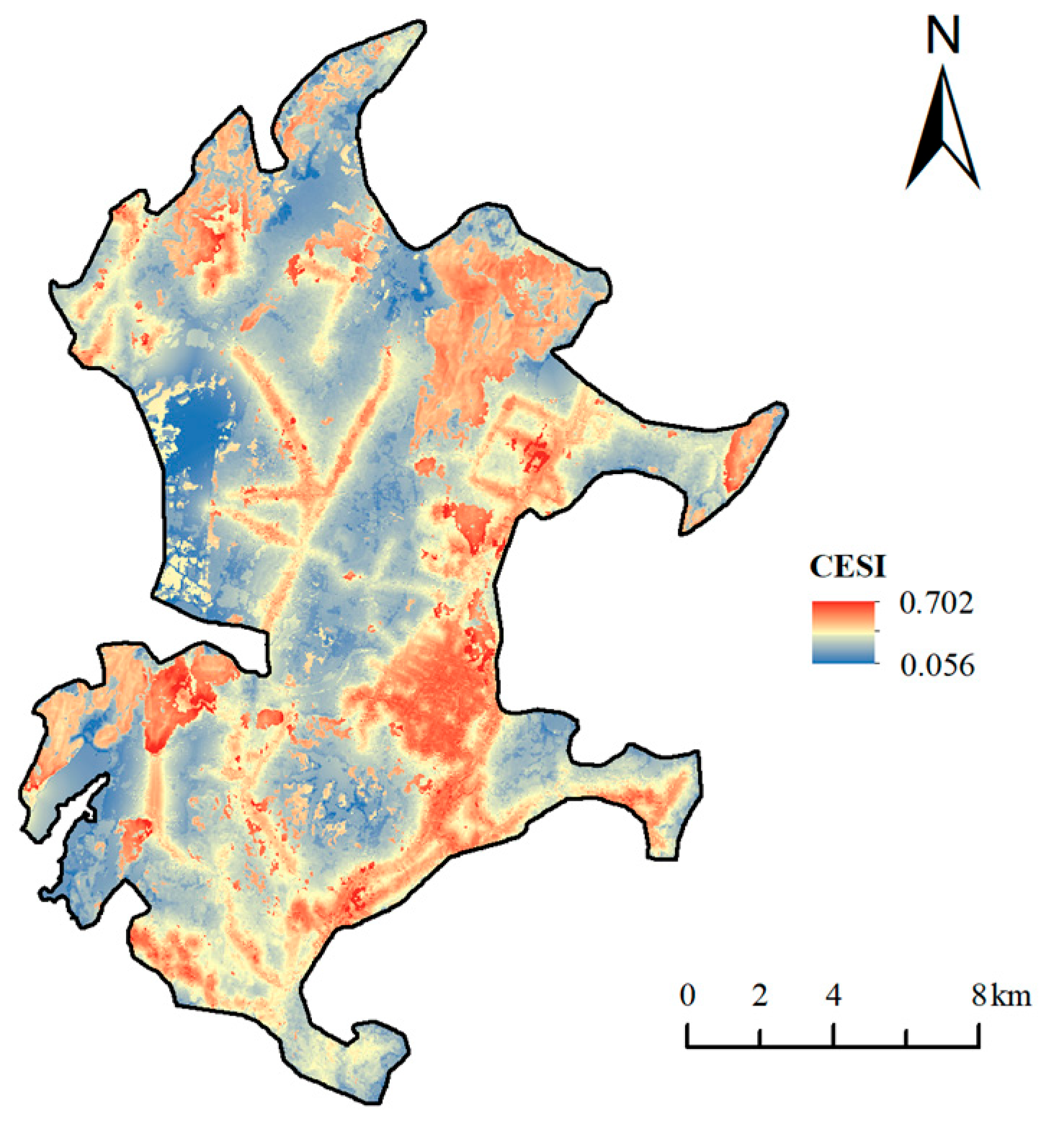
4.2. CESI Calculations
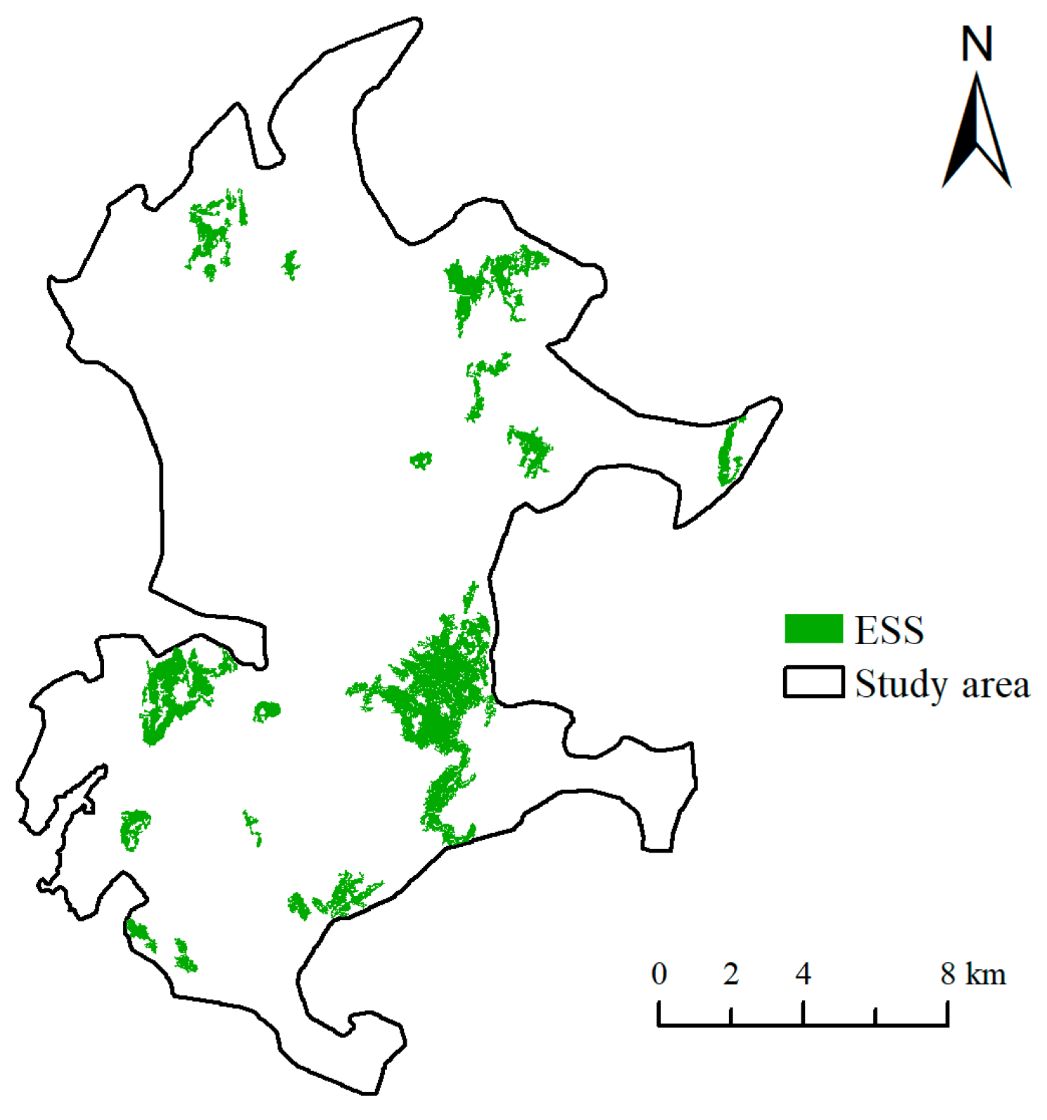
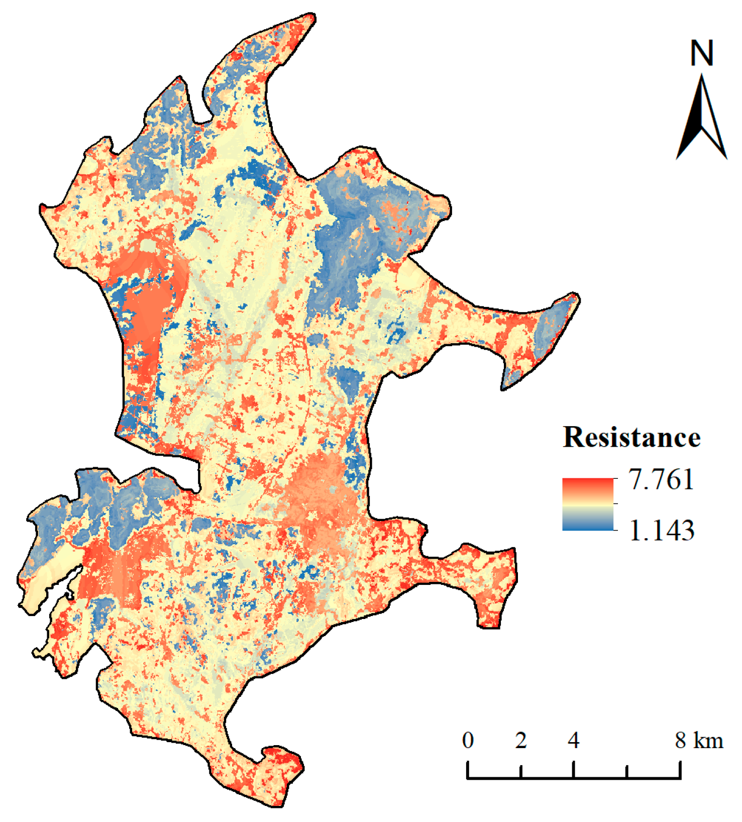
4.3. Extraction of Ecological Sources and Results of Combined Resistance Surface Construction
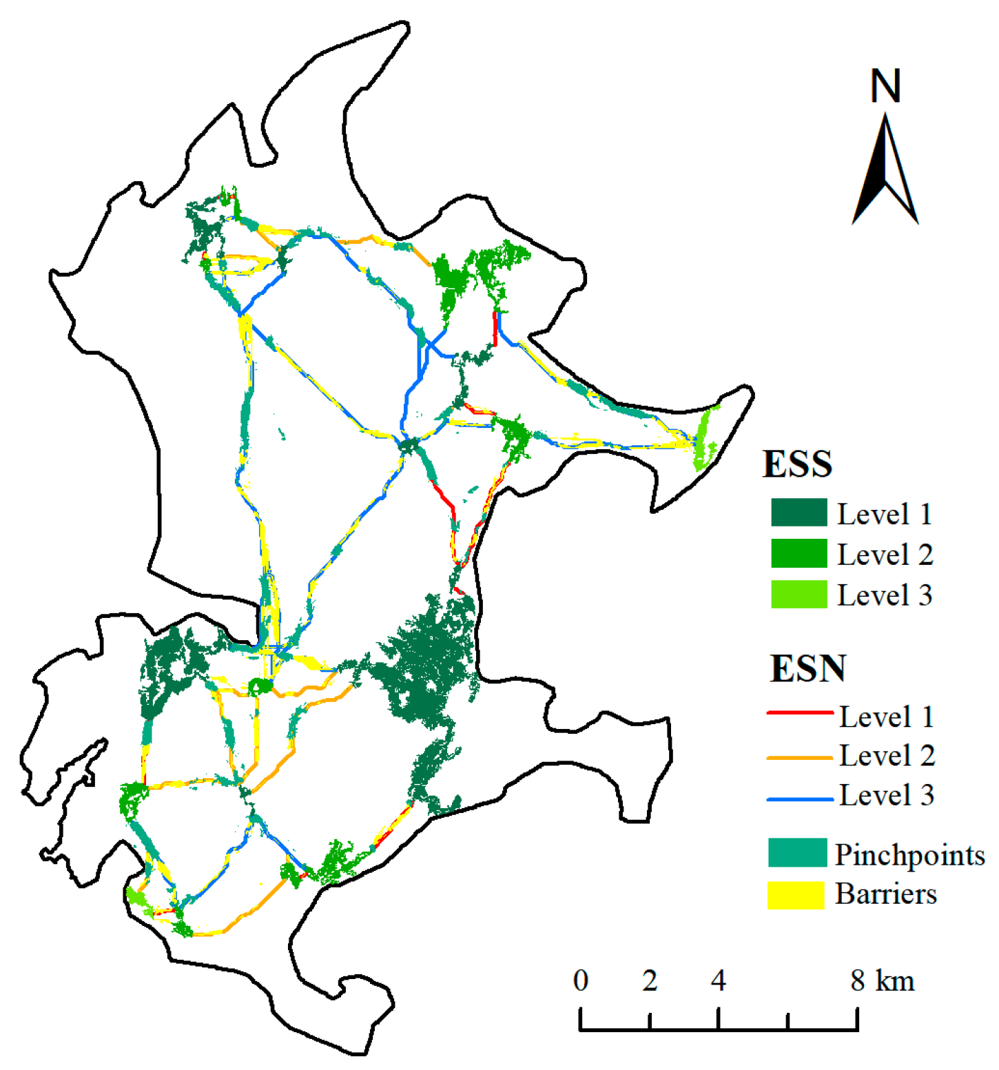
4.4. Construction of an Ecosystem Service Network on Pingtan Island
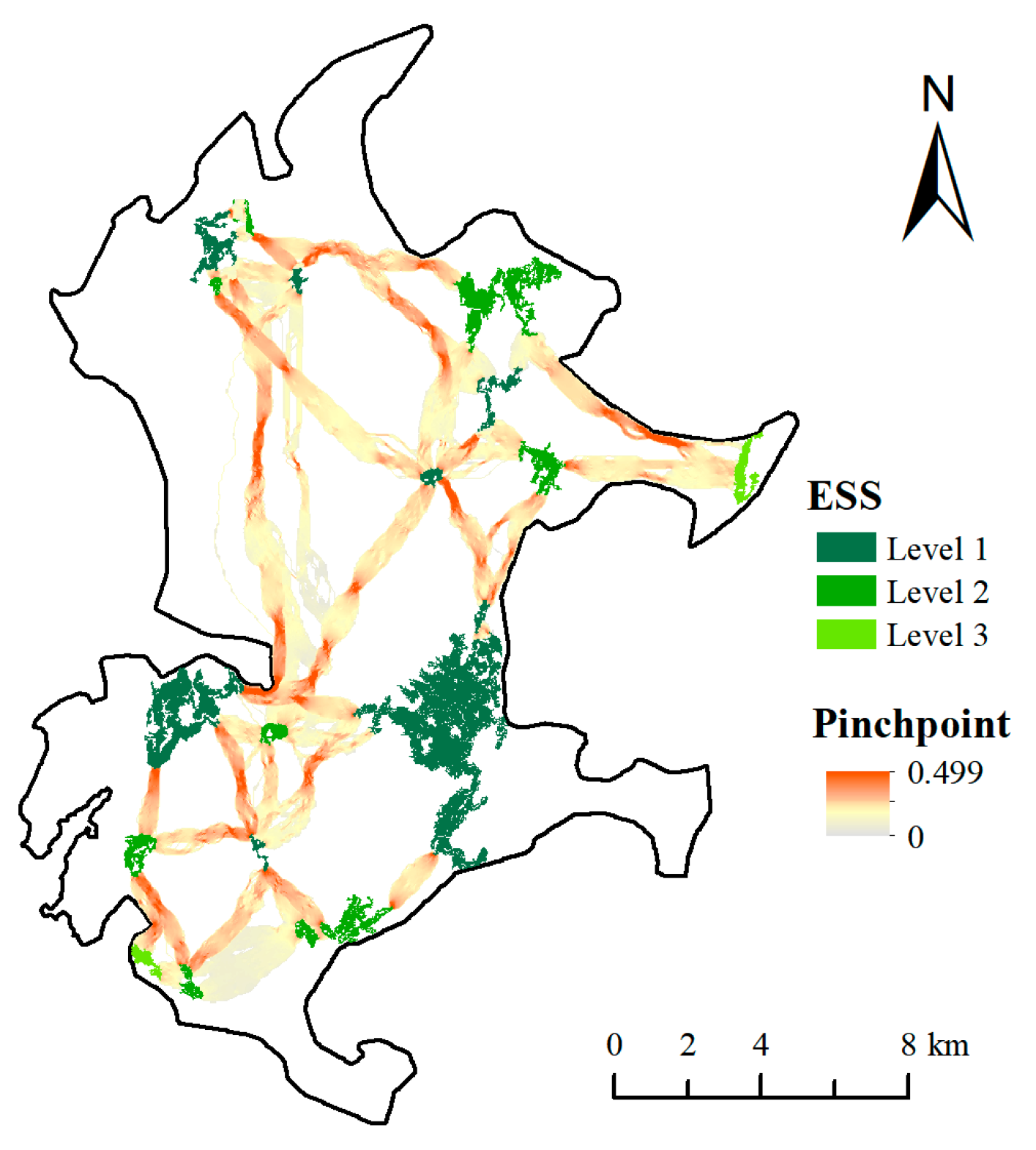
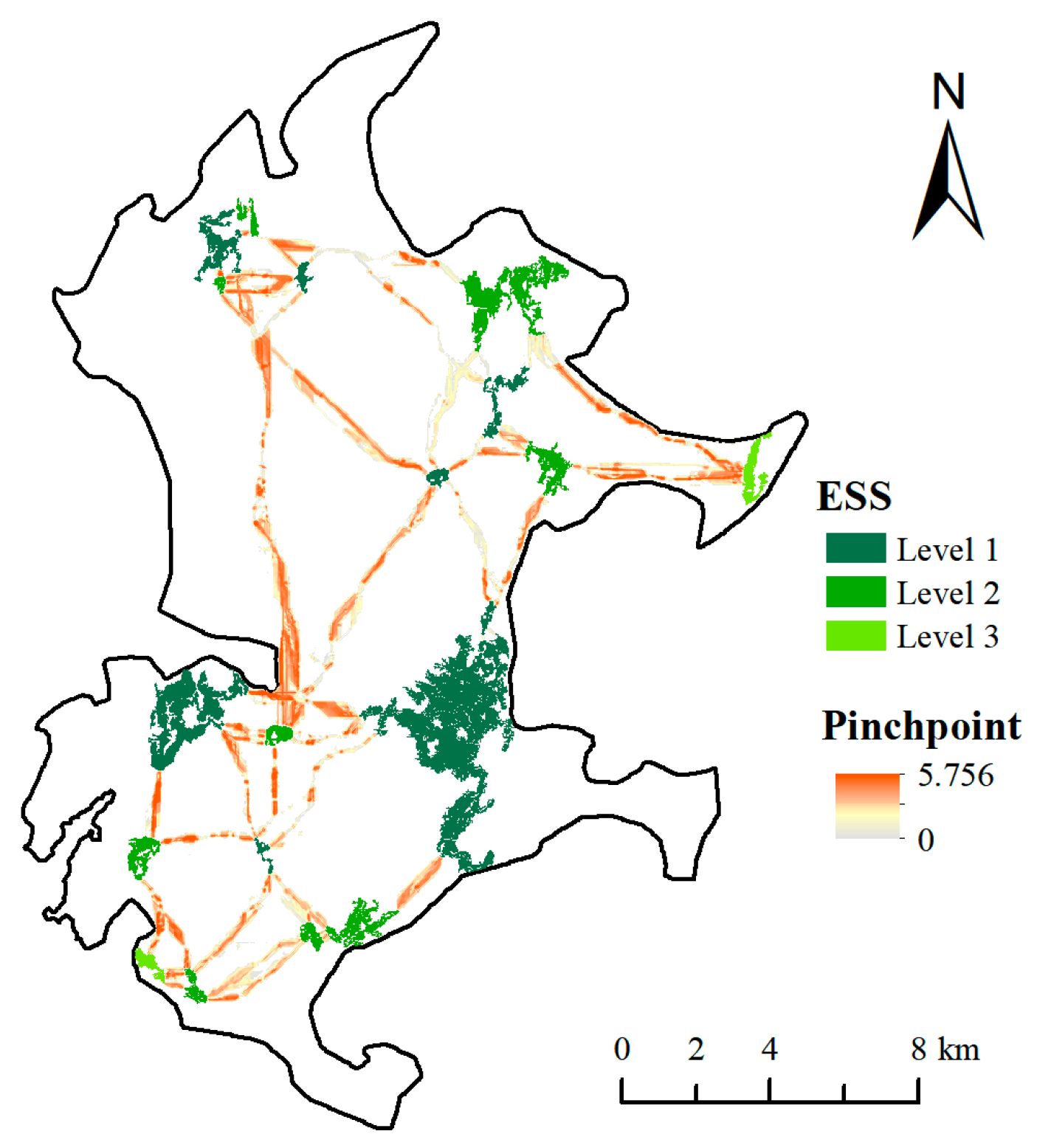
4.5. Identification of “Pinchpoints” and Barriers in Ecosystem Services Networks
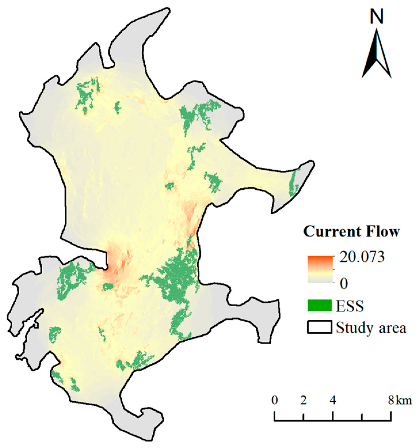
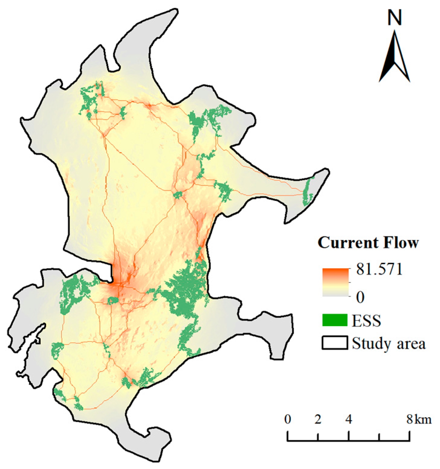
4.6. Optimization of Ecosystem Service Networks
5. Discussion
5.1. Rationalization of the Integrated Ecosystem Service Assessment Index
5.2. Methods for Building Ecosystem Service Networks
5.3. Optimization Methods for Ecosystem Service Networks
5.4. Recommendations and Measures
- (1)
- The Level-1 corridor and the Level-1 source area are the key areas for ecological function restoration and enhancement. Due to the overlap with the built-up area of the city, although the comprehensive ecosystem service function is good, it is very easy to be interfered by human activities, so the focus should be on the enhancement of ecological function.
- (2)
- Level-2 and Level-3 source areas should focus on improving CES, and develop richer eco-tourism venues, such as mangrove wetlands, science education bases, fishing villages and ancient towns, with the help of the characteristic coastal zone landscape resources, so as to improve CES. The Level-2 and Level-3 corridors, as barriers to protect the ecosystem service function of the source area, also need to form a network connection. In addition, the corridor connection in the northwestern part of the study area is relatively decentralized, and should be supplemented to strengthen the internal and external connections of the source area.
- (3)
- The “pinchpoints” are the most concentrated areas of energy flow or species migration between source areas, and natural restoration should be emphasized. The land use type in the “pinchpoints” at the study area level is mainly arable land, and the protection and management should be strengthened, and the occupation of construction land should be strictly prohibited. Ecological measures such as vegetation cultivation, mixed agriculture and forestry, and returning farmland to forests should be adopted, and at the same time, the cultivated land should be transformed into ecological, cultural and tourism-type cultivated land, such as picking gardens, nature education bases, and sightseeing farms, so as to activate the cultural and ecological system service function of cultivated land.
- (4)
- Barriers are areas that impede the spread of species in the region and need to be repaired and improved to enhance the overall ecological connectivity, with the key being artificial restoration. The results of the study show that large areas of cultivated land also exist in the barriers on Pingtan Island. Ecological engineering techniques, such as vegetation buffer zone construction and soil improvement, should be introduced to activate the function of “stepping stones” in species migration. Secondly, vegetation planting should be strengthened, and native plants with good wind and flood resistance should be selected, such as pioneer tree species like Tongva, Seaside Hibiscus, and Bitterroot, in order to improve the stability of the ecosystem. Subsequently, continuous monitoring and assessment of the ecological restoration effect is required so that the strategy can be adjusted in a timely manner. In addition, key nodes of urban roads should be equipped with ecological culverts, animal passages or green flyovers as far as possible to safeguard species migration and hydrological connectivity and reduce ecological fragmentation.
- (5)
- Determining appropriate corridor widths is essential for defining the spatial scope of corridor optimization. Based on the proportion and spatial distribution of land cover types within different corridor widths, targeted recommendations are proposed for each corridor level. As the core pathway for ecosystem service connectivity, Level-1 corridors are highly susceptible to the expansion of construction land and contain a limited proportion of water bodies; therefore, their width should be restricted to within 60 m. To maintain ecological integrity, disturbance sources must be strictly controlled, and the development of non-ecological facilities should be avoided. Marginal and unused lands should be prioritized for ecological restoration, including green replanting and the rehabilitation of urban water systems through dredging and expansion. Low-impact cultural and recreational features—such as forest trails, ecological boardwalks, and observation platforms—can be incorporated to enhance CES and public engagement, provided they do not compromise ecological connectivity. Level-2 corridors, functioning as supporting ecological links and mediators between natural and human-modified systems, are affected by both agricultural practices and construction land encroachment. Their width should be maintained within 90 m, with emphasis on promoting ecologically compatible land uses such as eco-agriculture, afforestation, and green leisure farming, in order to reduce the negative impact of large-scale monoculture or built-up land. Level-3 corridors, which serve as auxiliary ecosystem service corridors, are characterized by extensive arable land, limited water bodies, and high environmental heterogeneity. Their width should also be controlled within 60 m, with a focus on ensuring ecological continuity and promoting cost-effective enhancement measures. This includes utilizing existing green spaces and water systems, and encouraging the coordinated integration of village greenways, irrigation channels, roadside greenbelts, and ecological corridors to strengthen landscape-level ecological connectivity.
5.5. Limitations and Prospects
6. Conclusions
Author Contributions
Funding
Institutional Review Board Statement
Informed Consent Statement
Data Availability Statement
Conflicts of Interest
Appendix A
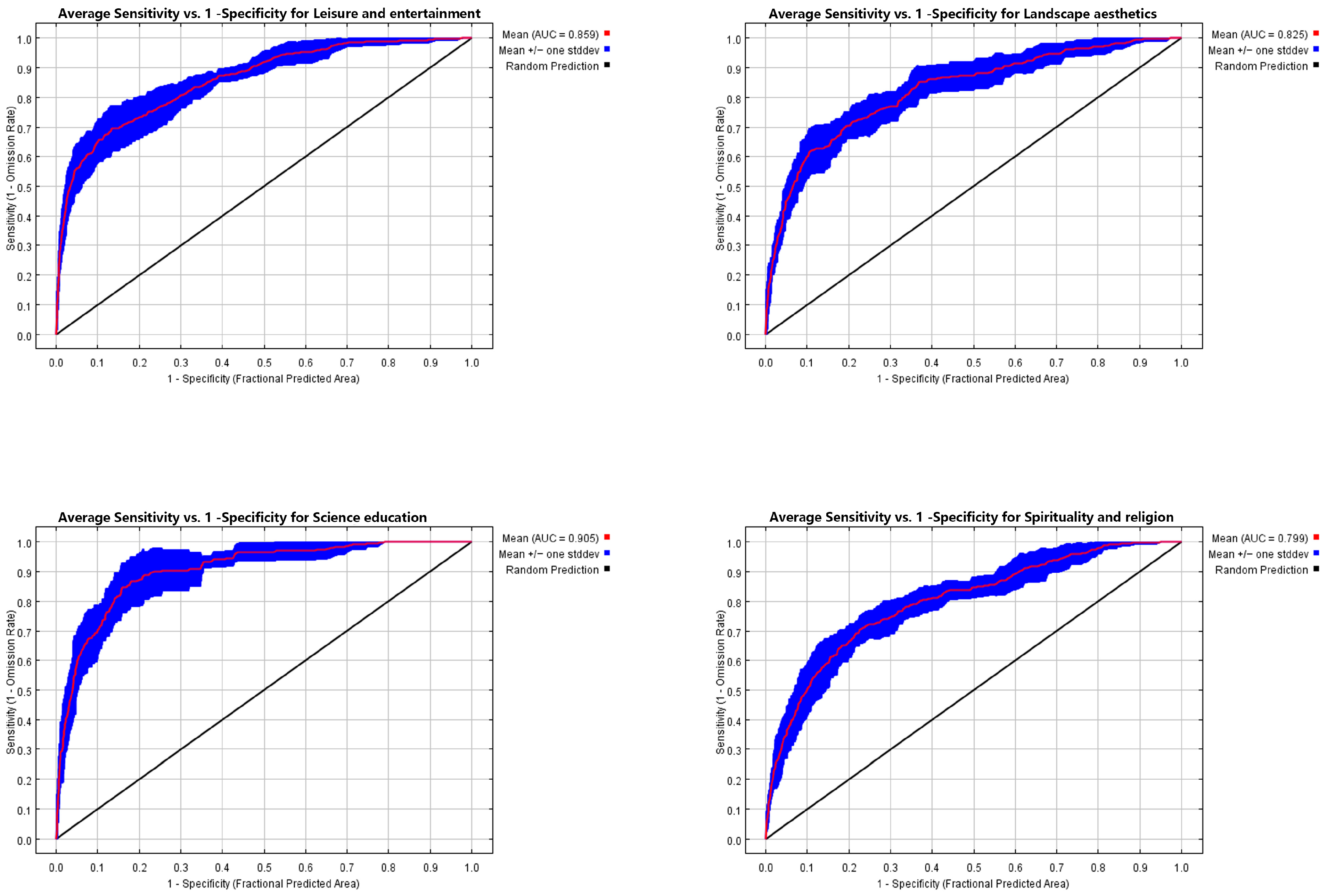

References
- Gillespie, R.G.; Roderick, G.K. Arthropods on islands: Colonization, speciation, and conservation. Annu. Rev. Entomol. 2002, 47, 595–632. [Google Scholar] [CrossRef]
- Jordan, P.; Fröhle, P. Bridging the gap between coastal engineering and nature conservation? A review of coastal ecosystems as nature-based solutions for coastal protection. J. Coast. Conserv. 2022, 26, 4. [Google Scholar] [CrossRef]
- Ehrlich, P.; Ehrlich, A. Extinction: The Causes and Consequences of the Disappearance of Species; Random House: New York, NY, USA, 1981. [Google Scholar]
- Millennium Ecosystem Assessment. Millennium Ecosystem Assessment; Millennium Ecosystem Assessment: Washington, DC, USA, 2001; Volume 2. [Google Scholar]
- Fedele, G.; Locatelli, B.; Djoudi, H. Mechanisms mediating the contribution of ecosystem services to human well-being and resilience. Ecosyst. Serv. 2017, 28, 43–54. [Google Scholar] [CrossRef]
- Martínez-López, J.; Bagstad, K.J.; Balbi, S.; Magrach, A.; Voigt, B.; Athanasiadis, I.; Pascual, M.; Willcock, S.; Villa, F. Towards globally customizable ecosystem service models. Sci. Total Environ. 2019, 650, 2325–2336. [Google Scholar] [CrossRef] [PubMed]
- Boumans, R.; Roman, J.; Altman, I.; Kaufman, L. The Multiscale Integrated Model of Ecosystem Services (MIMES): Simulating the interactions of coupled human and natural systems. Ecosyst. Serv. 2015, 12, 30–41. [Google Scholar] [CrossRef]
- Fish, R.; Church, A.; Winter, M. Conceptualising cultural ecosystem services: A novel framework for research and critical engagement. Ecosyst. Serv. 2016, 21, 208–217. [Google Scholar] [CrossRef]
- Sherrouse, B.C.; Semmens, D.J.; Ancona, Z.H. Social Values for Ecosystem Services (SolVES): Open-source spatial modeling of cultural services. Environ. Model. Softw. 2022, 148, 105259. [Google Scholar] [CrossRef]
- Ball, J. Towards a methodology for mapping ‘regions for sustainability’using PPGIS. Prog. Plan. 2002, 58, 81–140. [Google Scholar] [CrossRef]
- Olander, L.P.; Johnston, R.J.; Tallis, H.; Kagan, J.; Maguire, L.A.; Polasky, S.; Urban, D.; Boyd, J.; Wainger, L.; Palmer, M. Benefit relevant indicators: Ecosystem services measures that link ecological and social outcomes. Ecol. Indic. 2018, 85, 1262–1272. [Google Scholar] [CrossRef]
- Liang, S.; Yang, F.; Zhang, J.; Xiong, S.; Xu, Z. Assessment and Management Zoning of Ecosystem Service Trade-Off/Synergy Based on the Social–Ecological Balance: A Case of the Chang-Zhu-Tan Metropolitan Area. Land 2024, 13, 127. [Google Scholar] [CrossRef]
- Phillips, S.J.; Anderson, R.P.; Schapire, R.E. Maximum entropy modeling of species geographic distributions. Ecol. Model. 2006, 190, 231–259. [Google Scholar] [CrossRef]
- Bradie, J.; Leung, B. A quantitative synthesis of the importance of variables used in MaxEnt species distribution models. J. Biogeogr. 2017, 44, 1344–1361. [Google Scholar] [CrossRef]
- Shi, Q.; Chen, H.; Liang, X.; Liu, D.; Geng, T.; Zhang, H. Combination of participatory mapping and Maxent model to visualize the cultural ecosystem services at county scale. Ecosyst. Serv. 2025, 72, 101710. [Google Scholar] [CrossRef]
- Wang, J.; Wu, W.; Yang, M.; Gao, Y.; Shao, J.; Yang, W.; Ma, G.; Yu, F.; Yao, N.; Jiang, H. Exploring the complex trade-offs and synergies of global ecosystem services. Environ. Sci. Ecotechnology 2024, 21, 100391. [Google Scholar] [CrossRef]
- Wang, Y.; Yu, Q.; Avirmed, B.; Zhao, J.; Sun, W.; Liu, Y.; Cui, H.; Khishigjargal, M.; Oyuntuya, S.; Dambadarjaa, N. The response of ecosystem services to ecological spatial network patterns in China’s arid and semi-arid regions. Ecol. Indic. 2025, 172, 113300. [Google Scholar] [CrossRef]
- Wu, X.; Wang, S.; Fu, B.; Liu, Y.; Zhu, Y. Land use optimization based on ecosystem service assessment: A case study in the Yanhe watershed. Land Use Policy 2018, 72, 303–312. [Google Scholar] [CrossRef]
- Jiang, H.; Peng, J.; Liu, M.; Dong, J.; Ma, C. Integrating patch stability and network connectivity to optimize ecological security pattern. Landsc. Ecol. 2024, 39, 54. [Google Scholar] [CrossRef]
- Xu, A.; Shi, J.; Zhao, L.; Ji, T.; Meng, X. Urban ventilation network identification to mitigate heat island effect. Sustain. Cities Soc. 2025, 125, 106364. [Google Scholar] [CrossRef]
- O’Neill, R.V.; Krummel, J.R.; Gardner, R.E.A.; Sugihara, G.; Jackson, B.; DeAngelis, D.L.; Milne, B.T.; Turner, M.G.; Zygmunt, B.; Christensen, S.W. Indices of landscape pattern. Landsc. Ecol. 1988, 1, 153–162. [Google Scholar] [CrossRef]
- Pani, A.K.; Mohanta, H.K. Online monitoring and control of particle size in the grinding process using least square support vector regression and resilient back propagation neural network. ISA Trans. 2015, 56, 206–221. [Google Scholar] [CrossRef]
- Lin, J.; Huang, C.; Wen, Y.; Liu, X. An assessment framework for improving protected areas based on morphological spatial pattern analysis and graph-based indicators. Ecol. Indic. 2021, 130, 108138. [Google Scholar] [CrossRef]
- Hu, X.; Xu, H. A new remote sensing index for assessing the spatial heterogeneity in urban ecological quality: A case from Fuzhou City, China. Ecol. Indic. 2018, 89, 11–21. [Google Scholar] [CrossRef]
- Geng, J.; Yu, K.; Sun, M.; Xie, Z.; Huang, R.; Wang, Y.; Zhao, Q.; Liu, J. Construction and optimisation of ecological networks in high-density central urban areas: The case of Fuzhou City, China. Remote Sens. 2023, 15, 5666. [Google Scholar] [CrossRef]
- Zeller, K.A.; McGarigal, K.; Whiteley, A.R. Estimating landscape resistance to movement: A review. Landsc. Ecol. 2012, 27, 777–797. [Google Scholar] [CrossRef]
- Peng, J.; Zhao, H.; Liu, Y. Urban ecological corridors construction: A review. Acta Ecol. Sin. 2017, 37, 23–30. [Google Scholar] [CrossRef]
- Tong, H.; Shi, P. Using ecosystem service supply and ecosystem sensitivity to identify landscape ecology security patterns in the Lanzhou-Xining urban agglomeration, China. J. Mt. Sci. 2020, 17, 2758–2773. [Google Scholar] [CrossRef]
- Zhang, L.; Peng, J.; Liu, Y.; Wu, J. Coupling ecosystem services supply and human ecological demand to identify landscape ecological security pattern: A case study in Beijing–Tianjin–Hebei region, China. Urban Ecosyst. 2017, 20, 701–714. [Google Scholar] [CrossRef]
- Ghasemi, A.; Miandoabchi, E.; Soroushnia, S. The attractiveness of seaport-based transport corridors: An integrated approach based on scenario planning and gravity models. Marit. Econ. Logist. 2021, 23, 522–547. [Google Scholar] [CrossRef]
- Jin, B.; Geng, J.; Ding, Z.; Guo, L.; Rui, Q.; Wu, J.; Peng, S.; Jin, R.; Fu, X.; Pan, H. Construction and optimization of ecological corridors in coastal cities based on the perspective of “structure-function”. Sci. Rep. 2024, 14, 27945. [Google Scholar] [CrossRef]
- Wei, H.; Fan, W.; Wang, X.; Lu, N.; Dong, X.; Zhao, Y.; Ya, X.; Zhao, Y. Integrating supply and social demand in ecosystem services assessment: A review. Ecosyst. Serv. 2017, 25, 15–27. [Google Scholar] [CrossRef]
- Shifaw, E.; Sha, J.; Li, X.; Bao, Z.; Zhou, Z. An insight into land-cover changes and their impacts on ecosystem services before and after the implementation of a comprehensive experimental zone plan in Pingtan island, China. Land Use Policy 2019, 82, 631–642. [Google Scholar] [CrossRef]
- Yu, F.; Cai, F.; Ren, J.; Liu, J. Island beach management strategy in China with different urbanization level–Take examples of Xiamen Island and Pingtan Island. Ocean Coast. Manag. 2016, 130, 328–339. [Google Scholar] [CrossRef]
- Lin, T.; Xue, X.; Shi, L.; Gao, L. Urban spatial expansion and its impacts on island ecosystem services and landscape pattern: A case study of the island city of Xiamen, Southeast China. Ocean Coast. Manag. 2013, 81, 90–96. [Google Scholar] [CrossRef]
- Zanaga, D.; Van De Kerchove, R.; Daems, D.; De Keersmaecker, W.; Brockmann, C.; Kirches, G.; Wevers, J.; Cartus, O.; Santoro, M.; Fritz, S. ESA WorldCover 10 m 2021 v200. 2022. Available online: https://zenodo.org/records/7254221 (accessed on 27 July 2025).
- Gupta, S.; Borrelli, P.; Panagos, P.; Alewell, C. An advanced global soil erodibility (K) assessment including the effects of saturated hydraulic conductivity. Sci. Total Environ. 2024, 908, 168249. [Google Scholar] [CrossRef]
- Wang, B.; Cheng, W. Effects of land use/cover on regional habitat quality under different geomorphic types based on InVEST model. Remote Sens. 2022, 14, 1279. [Google Scholar] [CrossRef]
- Gashaw, T.; Bantider, A.; Zeleke, G.; Alamirew, T.; Jemberu, W.; Worqlul, A.W.; Dile, Y.T.; Bewket, W.; Meshesha, D.T.; Adem, A.A. Evaluating InVEST model for estimating soil loss and sediment export in data scarce regions of the Abbay (Upper Blue Nile) Basin: Implications for land managers. Environ. Chall. 2021, 5, 100381. [Google Scholar] [CrossRef]
- Du, C.; Sun, F.; Yu, J.; Liu, X.; Chen, Y. New interpretation of the role of water balance in an extended Budyko hypothesis in arid regions. Hydrol. Earth Syst. Sci. 2016, 20, 393–409. [Google Scholar] [CrossRef]
- Stockmann, U.; Adams, M.A.; Crawford, J.W.; Field, D.J.; Henakaarchchi, N.; Jenkins, M.; Minasny, B.; McBratney, A.B.; De Courcelles, V.D.R.; Singh, K. The knowns, known unknowns and unknowns of sequestration of soil organic carbon. Agric. Ecosyst. Environ. 2013, 164, 80–99. [Google Scholar] [CrossRef]
- Chen, W.; Pourghasemi, H.R.; Kornejady, A.; Zhang, N. Landslide spatial modeling: Introducing new ensembles of ANN, MaxEnt, and SVM machine learning techniques. Geoderma 2017, 305, 314–327. [Google Scholar] [CrossRef]
- Murata, C.; Mantel, S.; de Wet, C.; Palmer, A.R. Lay knowledge of ecosystem services in rural Eastern Cape Province, South Africa: Implications for intervention program planning. Water Econ. Policy 2019, 5, 1940001. [Google Scholar] [CrossRef]
- Wang, P.; Li, N.; He, Y.; He, Y. Evaluation of Cultural Ecosystem Service Functions in National Parks from the Perspective of Benefits of Community Residents. Land 2022, 11, 1566. [Google Scholar] [CrossRef]
- Mazziotta, M.; Pareto, A. Principal component analysis for constructing socio-economic composite indicators: Theoretical and empirical considerations. SN Soc. Sci. 2024, 4, 114. [Google Scholar] [CrossRef]
- Qi, K.; Fan, Z.; Xie, Y. The influences of habitat proportion and patch-level structural factors in the spatial habitat importance ranking for connectivity and implications for habitat conservation. Urban For. Urban Green. 2021, 64, 127239. [Google Scholar] [CrossRef]
- Tian, M.; Gao, J.; Song, G.; Feng, C. Prioritizing ecological conservation strategies to enhance national ecological connectivity in China. Ecol. Indic. 2023, 150, 110273. [Google Scholar] [CrossRef]
- Xu, J.; Wang, J.; Xiong, N.; Chen, Y.; Sun, L.; Wang, Y.; An, L. Analysis of ecological blockage pattern in Beijing important ecological function area, China. Remote Sens. 2022, 14, 1151. [Google Scholar] [CrossRef]
- Liu, C.; Newell, G.; White, M.; Bennett, A.F. Identifying wildlife corridors for the restoration of regional habitat connectivity: A multispecies approach and comparison of resistance surfaces. PLoS ONE 2018, 13, e206071. [Google Scholar] [CrossRef]
- Liang, G.; Niu, H.; Li, Y. A multi-species approach for protected areas ecological network construction based on landscape connectivity. Glob. Ecol. Conserv. 2023, 46, e2569. [Google Scholar] [CrossRef]
- Hou, W.; Zhou, W.; Li, J.; Li, C. Simulation of the potential impact of urban expansion on regional ecological corridors: A case study of Taiyuan, China. Sustain. Cities Soc. 2022, 83, 103933. [Google Scholar] [CrossRef]
- Chen, C.; Xu, A.; Ding, P.; Wang, Y. The small-island effect and nestedness in assemblages of medium-and large-bodied mammals on Chinese reservoir land-bridge islands. Basic Appl. Ecol. 2019, 38, 47–57. [Google Scholar] [CrossRef]
- Rusinko, A.; Druga, M. Barrier and corridor effects in cost-distance-based accessibility approximation for LUCC modelling: A case study of Slovakia from 2000 to 2018. Landsc. Res. 2022, 47, 316–332. [Google Scholar] [CrossRef]
- Shishmanova, M.V. Cultural tourism in cultural corridors, itineraries, areas and cores networked. Procedia-Soc. Behav. Sci. 2015, 188, 246–254. [Google Scholar] [CrossRef]
- Xu, H.; Zhao, G.; Fagerholm, N.; Primdahl, J.; Plieninger, T. Participatory mapping of cultural ecosystem services for landscape corridor planning: A case study of the Silk Roads corridor in Zhangye, China. J. Environ. Manag. 2020, 264, 110458. [Google Scholar] [CrossRef]
- Chen, H.; Yan, W.; Li, Z.; Wende, W.; Xiao, S. A framework for integrating ecosystem service provision and connectivity in ecological spatial networks: A case study of the Shanghai metropolitan area. Sustain. Cities Soc. 2024, 100, 105018. [Google Scholar] [CrossRef]
- Dai, L.; Liu, Y.; Luo, X. Integrating the MCR and DOI models to construct an ecological security network for the urban agglomeration around Poyang Lake, China. Sci. Total Environ. 2021, 754, 141868. [Google Scholar] [CrossRef] [PubMed]
- Sun, W.; Yu, Q.; Xu, C.; Zhao, J.; Wang, Y.; Miao, Y. Construction and optimization of ecological spatial network in typical mining cities of the Yellow River Basin: The case study of Shenmu City, Shaanxi. Ecol. Process 2024, 13, 60. [Google Scholar] [CrossRef]
- Rall, E.; Hansen, R.; Pauleit, S. The added value of public participation GIS (PPGIS) for urban green infrastructure planning. Urban For. Urban Green. 2019, 40, 264–274. [Google Scholar] [CrossRef]
- Guo, R.; Lin, L.; Xu, J.; Dai, W.; Song, Y.; Dong, M. Spatio-temporal characteristics of cultural ecosystem services and their relations to landscape factors in Hangzhou Xixi National Wetland Park, China. Ecol. Indic. 2023, 154, 110910. [Google Scholar] [CrossRef]
- Zuo, Y.; Zhang, L. Research on Local Ecosystem Cultural Services in the Jiangnan Water Network Rural Areas: A Case Study of the Ecological Green Integration Demonstration Zone in the Yangtze River Delta, China. Land 2023, 12, 1373. [Google Scholar] [CrossRef]
- Sahavacharin, A.; Sompongchaiyakul, P.; Thaitakoo, D. The effects of land-based change on coastal ecosystems. Landsc. Ecol. Eng. 2022, 18, 351–366. [Google Scholar] [CrossRef]
- Fang, J.; Liu, Y.; Wu, M.; Liu, Q.; Xu, M. New practices of land-sea coordination in coastal zone ecological security integration: A case study of Nantong. Ecol. Eng. 2024, 202, 107238. [Google Scholar] [CrossRef]
- Woodroffe, C.D.; Evelpidou, N.; Delgado-Fernandez, I.; Green, D.R.; Karkani, A.; Ciavola, P. Coastal Systems: The Dynamic Interface Between Land and Sea. In Research Directions, Challenges and Achievements of Modern Geography; Springer: Berlin/Heidelberg, Germany, 2023; pp. 207–229. [Google Scholar]
- Ke, L.; Zhao, Y.; Wang, Q.; Yin, S.; Liu, W. Construction of coastal zone ecological network based on the perspective of land-sea integration: A case study of Jinzhou City, China. Ocean Coast. Manag. 2024, 254, 107204. [Google Scholar] [CrossRef]
- Thiele, J.; Buchholz, S.; Schirmel, J. Using resistance distance from circuit theory to model dispersal through habitat corridors. J. Plant Ecol. 2018, 11, 385–393. [Google Scholar] [CrossRef]
- Tischendorf, L.; Wissel, C. Corridors as conduits for small animals: Attainable distances depending on movement pattern, boundary reaction and corridor width. Oikos 1997, 79, 603–611. [Google Scholar] [CrossRef]
- Balzan, M.V.; Potschin-Young, M.; Haines-Young, R. Island ecosystem services: Insights from a literature review on case-study island ecosystem services and future prospects. Int. J. Biodivers. Sci. Ecosyst. Serv. Manag. 2018, 14, 71–90. [Google Scholar] [CrossRef]
- Zhang, L.; Wan, Y.; Sun, Y.; He, G.; Lei, X.; Wei, X.; Jin, G. Optimizing ecological security patterns in a megacity by enhancing urban–rural connectivity: Insights from Wuhan, China. Appl. Geogr. 2025, 176, 103535. [Google Scholar] [CrossRef]
- Du, R.; Liu, B.; Xu, M. Current status and trends in island ecosystem services research: A bibliometric analysis from 2000 to 2023. Mar. Policy 2024, 163, 106098. [Google Scholar] [CrossRef]
- Deng, J.; Lin, Y.; Zhou, M.; Wu, C.; Chen, B.; Xiao, G.; Cai, J. Ecosystem services dynamics response to tremendous reclamation in a coastal island city. Ecosyst. Health Sustain. 2019, 5, 155–168. [Google Scholar] [CrossRef]
- Wilson, A.M.W.; Forsyth, C. Restoring near-shore marine ecosystems to enhance climate security for island ocean states: Aligning international processes and local practices. Mar. Policy 2018, 93, 284–294. [Google Scholar] [CrossRef]
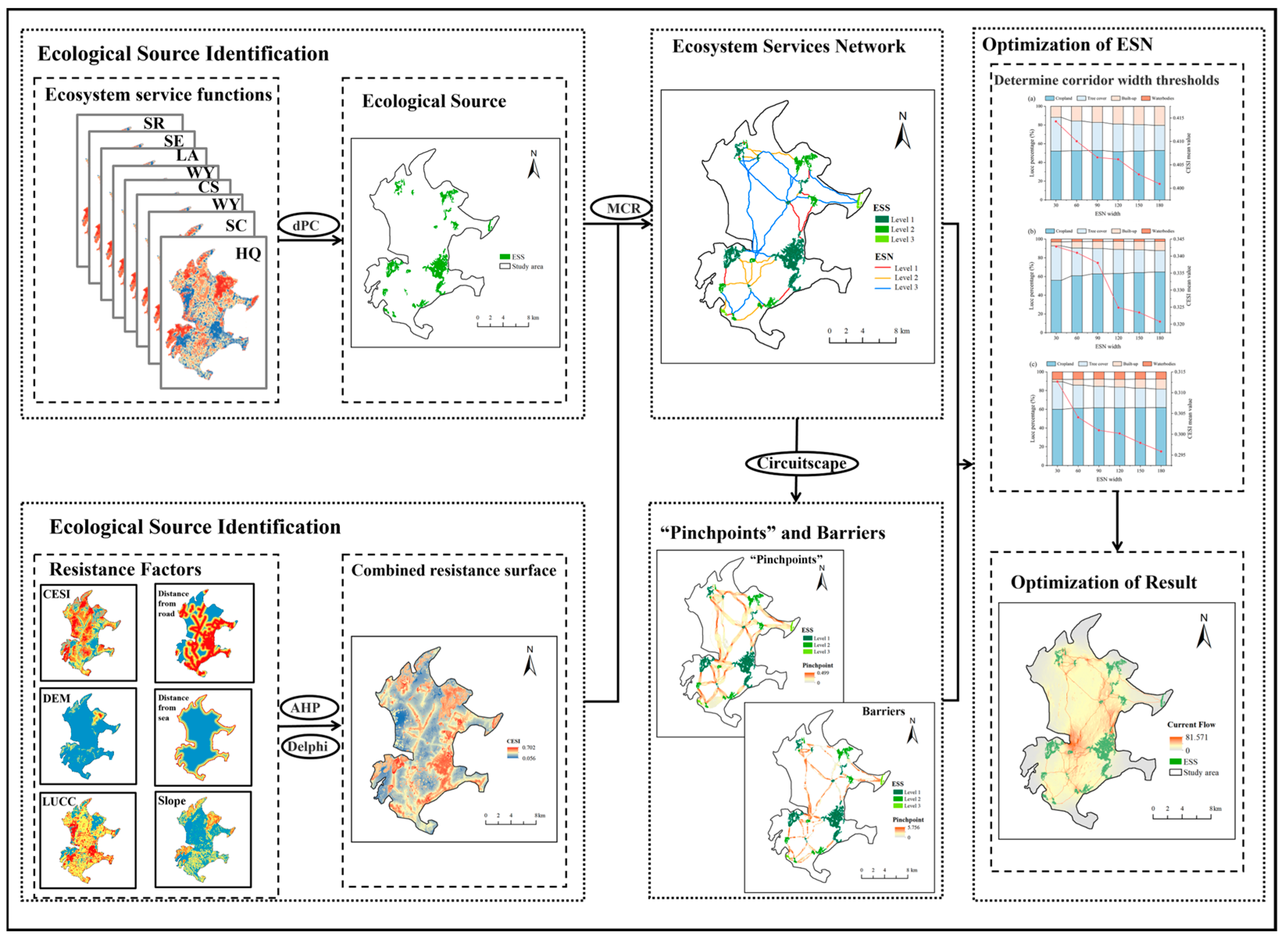
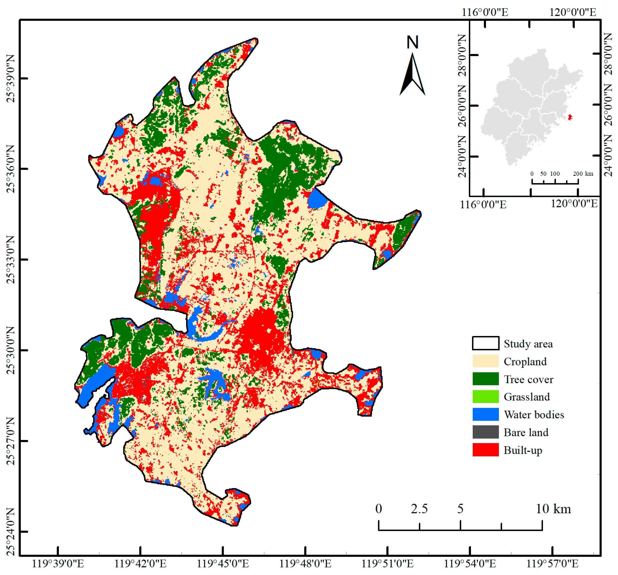
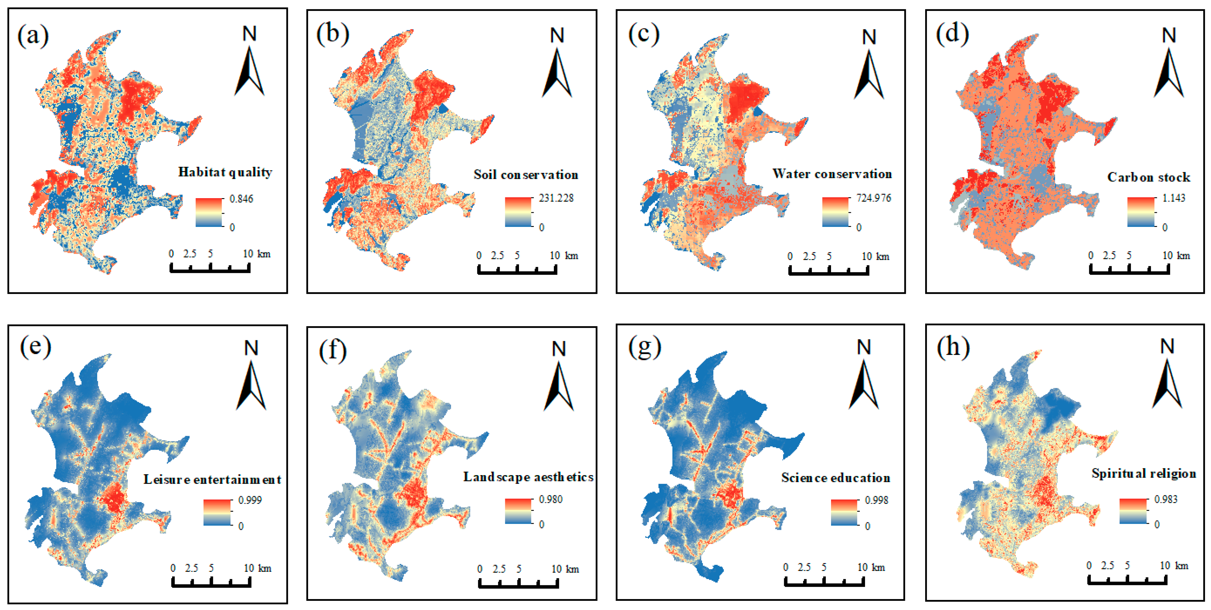


| Data Type | File Format Specification | Resolution | Source |
|---|---|---|---|
| 2022 Land use data | raster | 30 m | The 30 m annual land cover datasets and its dynamics in China from 2022 (https://zenodo.org/records/8176941, accessed on 27 July 2025) |
| Pingtan Island Boundary | shp | / | Fuzhou Natural Resources Planning Bureau (http://zygh.fuzhou.gov.cn/, accessed on 27 July 2025) |
| DEM | raster | 12.5 m | Distributed Activity Archive Centre for Satellite Equipment, Alaska, United States (https://asf.alaska.edu/, accessed on 27 July 2025) |
| POI, urban roads, motorways, etc. | shp | / | OpenStreetMap (https://www.openstreetmap.org/, accessed on 27 July 2025) |
| Average annual rainfall | raster | 1000 m | National Centre for Earth System Data Science (http://www.geodata.cn/, accessed on 27 July 2025) |
| Average annual potential evapotranspiration | raster | 1000 m | National Tibetan Plateau Science Data Centre (https://www.tpdc.ac.cn/, accessed on 27 July 2025) |
| Soil quality | raster | 250 m | SoilGirds250m2.0 database (https://soilgrids.org, accessed on 27 July 2025) |
| Root depth | raster | 250 m | https://doi.org/10.1016/j.scitotenv.2023.168249, accessed on 27 July 2025 |
| Category of Resistance | Weight Value | Barrier Effect Factor | Resistance Value | Category of Resistance | Weight Value | Barrier Effect Factor | Resistance Value |
|---|---|---|---|---|---|---|---|
| LUCC | 0.4545 | Tree cover | 1 | DEM | 0.1675 | ≤50 m | 1 |
| Grassland | 3 | (50, 150] m | 3 | ||||
| Cropland | 5 | (150, 250] m | 5 | ||||
| Bareland | 7 | (250, 350] m | 7 | ||||
| Built-up | 9 | >350 m | 9 | ||||
| Water bodies | 5 | ||||||
| Slope | 0.0985 | (0°, 3°] | 1 | CESI | 0.1526 | (0, 0.195] | 9 |
| (3°, 5°] | 3 | (0.195, 0.268] | 7 | ||||
| (5°, 15°] | 5 | (0.268, 0.352] | 5 | ||||
| (15°, 25°] | 7 | (0.352, 0.438] | 3 | ||||
| >25° | 9 | (0.438, 1.000] | 1 | ||||
| Distance from road | 0.0715 | ≤300 m | 9 | Distance from sea | 0.0554 | >1000 m | 1 |
| (300, 600] m | 7 | (500, 1000] m | 3 | ||||
| (600, 900] m | 5 | (200, 500] m | 5 | ||||
| (900, 1200] m | 3 | (100, 200] m | 7 | ||||
| >1200 m | 1 | ≤100 m | 9 |
| Category | Function | Total Width Setting (m) | Buffer Width Setting (m) |
|---|---|---|---|
| Ecological corridors | invertebrate population | (3, 12] | (1, 1] (≈1) |
| Migratory needs of birds; largely meets migration and dispersal of plants and animals; Safeguards fish, small mammals, reptiles, and amphibians by preserving their habitats | (12, 200] | (1, 10] | |
| Facilitate the migration and dispersal of flora and fauna; the minimum width required for the survival of tree populations | (200, 600] | (10, 50] | |
| Medium and variable temperature mammals | (600, 1200] | (50, 100] |
| Category | Function | Total Width Setting (m) | Buffer Width Setting (m) |
|---|---|---|---|
| Recreation corridors | Walking, short trips, sightseeing, leisure and entertainment | (2, 5] | (0, 1] |
| Cycling, jogging and dog walking | (5, 8] | (0, 1] | |
| Functions of campsites, recreation, party and catering activities that provide appropriate staging space and recreational facilities | (8, 30] | (1, 8] | |
| Science education, cultural heritage sources, nature education trails, etc. | (30, 100] | (0, 10] |
| Ingredient | PC-1 | PC-2 | PC-3 | PC-4 |
|---|---|---|---|---|
| HQ | −0.741 | 0.422 | −0.263 | 0.401 |
| SC | −0.500 | 0.584 | −0.266 | −0.503 |
| WY | −0.564 | 0.436 | 0.642 | −0.176 |
| CS | −0.724 | 0.595 | −0.072 | 0.223 |
| LE | 0.846 | 0.477 | −0.016 | 0.033 |
| LA | 0.707 | 0.606 | 0.045 | 0.002 |
| SE | 0.814 | 0.344 | 0.192 | 0.275 |
| SR | 0.758 | 0.222 | −0.254 | −0.191 |
| Eigenvalue | 4.094 | 1.827 | 0.660 | 0.608 |
| Characteristic contribution/% | 51.169 | 22.843 | 8.256 | 7.598 |
| Cumulative contribution/% | 51.169 | 74.012 | 82.268 | 89.866 |
| Pinch Points | Barriers | |||
|---|---|---|---|---|
| Area/km2 | Proportion/% | Area/km2 | Proportion/% | |
| Tree cover | 1.7810 | 30.95% | 0.0018 | 0.02% |
| Grassland | 0.0000 | 0.000% | 0.0000 | 0.00% |
| Cropland | 3.1242 | 54.29% | 5.1003 | 71.11% |
| Built-up | 0.4983 | 8.66% | 1.3014 | 18.15% |
| Bare land | 0.0017 | 0.03% | 0.0027 | 0.04% |
| Water bodies | 0.3493 | 6.07% | 0.7659 | 10.68% |
Disclaimer/Publisher’s Note: The statements, opinions and data contained in all publications are solely those of the individual author(s) and contributor(s) and not of MDPI and/or the editor(s). MDPI and/or the editor(s) disclaim responsibility for any injury to people or property resulting from any ideas, methods, instructions or products referred to in the content. |
© 2025 by the authors. Licensee MDPI, Basel, Switzerland. This article is an open access article distributed under the terms and conditions of the Creative Commons Attribution (CC BY) license (https://creativecommons.org/licenses/by/4.0/).
Share and Cite
Liu, J.; Jin, B.; Dong, J.; Ding, G. Integrating InVEST and MaxEnt Models for Ecosystem Service Network Optimization in Island Cities: Evidence from Pingtan Island, China. Sustainability 2025, 17, 8470. https://doi.org/10.3390/su17188470
Liu J, Jin B, Dong J, Ding G. Integrating InVEST and MaxEnt Models for Ecosystem Service Network Optimization in Island Cities: Evidence from Pingtan Island, China. Sustainability. 2025; 17(18):8470. https://doi.org/10.3390/su17188470
Chicago/Turabian StyleLiu, Jinyan, Bowen Jin, Jianwen Dong, and Guochang Ding. 2025. "Integrating InVEST and MaxEnt Models for Ecosystem Service Network Optimization in Island Cities: Evidence from Pingtan Island, China" Sustainability 17, no. 18: 8470. https://doi.org/10.3390/su17188470
APA StyleLiu, J., Jin, B., Dong, J., & Ding, G. (2025). Integrating InVEST and MaxEnt Models for Ecosystem Service Network Optimization in Island Cities: Evidence from Pingtan Island, China. Sustainability, 17(18), 8470. https://doi.org/10.3390/su17188470


