Article

Exploring the Quality of Urban Agricultural Landscapes Through an Analysis of Globally Distributed Case Studies

Department of Cultural Heritage, University of Bologna, 48121 Ravenna, Italy
Sustainability 2025, 17(18), 8155; https://doi.org/10.3390/su17188155
Submission received: 14 July 2025 / Revised: 2 September 2025 / Accepted: 5 September 2025 / Published: 10 September 2025

Abstract

Urban agricultural landscapes (UALs) constitute a vital component of urban agriculture (UA) initiatives. Nevertheless, rational and systematic evaluation guidelines remain lacking. This study, based on 16 UA case studies, aims to explore the value of UAL quality through a constructed evaluation system. It uses a combined methodology of literature review and case study analysis, alongside an urban agricultural landscape quality assessment (UALQA) framework. The evaluation system contains three dimensions—landscape design, landscape space, and landscape facilities—and 8 indicators with 25 sub-indicators. This study quantitatively assesses the 16 representative cases. The findings indicate that landscape design exerts the greatest influence on urban agricultural landscape quality (UALQ). Within the landscape space dimension, Sydney City Farm achieves the highest score (0.82). Within the landscape design dimension, Rijnvliet Edible Neighbourhood achieves the highest score (0.99). Within the landscape facilities dimension, La Ferme du Rail achieves the highest score (0.39). Through quantitative analysis, this study clarifies the characteristics of each case and proposes specific design strategies across the three dimensions to enhance UALQ. This research not only provides empirical evidence for constructing and applying quality systems but also stimulates fresh perspectives on the opportunities presented by UALs.

1. Introduction

In the 21st century, rapid global urbanisation gave rise to a new division of urban forms: central cities, built-up areas, global cities, metropoles, megalopolis, and megacities [1]. However, urban sprawl has led to a growing contradiction between these urban forms and the natural landscape. In 1800, only 10% of the population lived in cities [2]; however, by 2000, this figure had risen to 47% [3]. By 2022, 4.52 billion inhabitants (57% of the population) lived in cities, and only 3.4 billion inhabitants lived in rural areas [3,4]. According to van Vliet et al. (2017), in 2000, 271 Mha of land was encroached upon by urbanisation, which is equivalent to 2.06% of the global ice-free surface [5]. By 2040, this figure will reach 621 Mha, which is equal to 4.72% of the global ice-free surface. Large-scale urban expansion in a short period of time has led to a sharp decrease in urban green areas, land fragmentation, and the destruction of the ecosystem. At the same time, built-up areas have changed the land use attributes of the surrounding areas, which has directly led to a reduction in food production. Simkin et al. (2022) showed that the reduction of natural landscapes due to urbanisation is a major driver of habitat loss [6]. Urban agricultural landscapes (UALs) can integrate fragmented urban landscapes and enhance urban ecological landscapes, and they are gradually becoming one of the most effective ways to solve urban problems.
By reviewing the literature on urban agricultural landscape quality (UALQ), I found that the current research in this field has primarily focused on landscape design, space, and facilities. In the majority of scholarly investigations, the landscape design dimension of urban agriculture (UA) has been extensively explored and debated. This dimension chiefly addresses the artistic and aesthetic expression of UALs, emphasising urban aesthetics, landscape presentation, and innovative design. As early as the beginning of the 20th century, Mollison proposed the concept of “permaculture” and elaborated on the value of natural elements in urban landscapes [7]. Meanwhile, he clarified the concept of edge design and established the fundamental principles of UAL design, thereby further advancing innovation in this field [7]. For instance, Biasi and Brunori analysed and introduced the use of edible plants as natural elements within urban aesthetics [8]. They further proposed enhancing urban landscape quality through crop design [8]. Hastuti et al. explored the aesthetic value of Makassar City’s UAL through visual assessments [9]. At the same time, numerous influential practices emerged globally [9]. For example, the “Lafayette Greens” in the United States, designed by Kenneth Weikal Landscape Architecture, emphasises the aesthetic design of UALs. The project uses a regular geometric layout and planting beds of different heights to create a vibrant and creative UAL [10].
Another category of research focuses on the exploration of landscape spaces. The landscape spatial dimension primarily addresses spatial organisation and social functions. It emphasises the spatial structure, regeneration, and activation of UA while paying attention to users’ spatial experiences. For instance, Bohn and Viljoen propose reintegrating urban spaces through agricultural production to create multifunctional areas [11]. Grimm’s “Food Urbanism” categorises agricultural systems into points, lines, and planes to construct urban landscape spaces [12]. Duany’s “Agrarian Urbanism” integrates agricultural landscapes into urban district structures while explicitly merging social values with spatial integration [13]. Mougeot examines the current state of UA in low- and middle-income cities from a territorial spatial perspective [14]. Compared to landscape design practices emphasising aesthetics, those concerning landscape space prioritise spatial regeneration and efficient utilisation. For example, VRAP Studio designed the “Sky Farm” project on urban fringe wastelands, reconfiguring site spaces [15].
In recent years, some studies have also begun to focus on the landscape facilities dimension of UA. This dimension primarily addresses the functional, supportive, and technological facilities of UA. It emphasises landscape infrastructure, alongside landscape agricultural techniques. For instance, Despommier outlined the functions, advantages, and technologies of vertical agriculture in “The vertical farm: feeding the world in the 21st century” [16]. Timmeren discussed the application of innovative agricultural models in urban contexts. He proposed the concept of “Sustainable Implant”, embedding UA in urban infrastructure systems [17]. In “Urban Agriculture and Community Values: The Green Transformation of Cities”, Newton explores three functional and technical forms of UA: UA embedded within the city’s full functionality, commercial UA, and vertical UA [18]. At the same time, practices involving landscape facilities have proliferated. For example, Thailand’s “Coro Field”, designed by IF Studio, creates a UAL through movable building structures and a modular agricultural facility system [19].
Current research provides significant practical and theoretical insights into landscape design, space, and facilities. However, current studies on UALQ have focused on establishing evaluation frameworks from specific perspectives to explore functionality. The academic field still lacks research on comprehensive and holistic systems of urban agricultural landscape quality assessment (UALQA), particularly that employing multiple global case studies as analytical samples. For example, Thiesen developed an evaluation framework related to the design of a UAL in order to explore its aesthetic expression [20]. However, he did not provide a comprehensive discussion of UALQ. At the same time, most studies on UALQ have adopted qualitative analyses, lacking unified quantitative metrics. For instance, Verzone et al. constructed an evaluation framework for UALs based on urban quality [1]. They utilised this framework to discuss multiple proposals for the Agro-Urban Park Bernex project in Switzerland [1]. However, as it does not quantify the indicators, it could not be used to intuitively and clearly express the differences between them. Furthermore, some studies have aimed to explore the integration of UA holistic systems and landscape analyses. Their indicators are diverse and fragmented, hindering data comparison. In UA practices, most UAL projects are marginalised by other urban industries. This means that the value of UALs remains in an exploratory phase. The absence of rational and systematic evaluation guidelines for most urban farm landscapes hinders their promotion and development.
This study, which is based on the discipline of landscape architecture and combines the interdisciplinary nature of UA, explores UA from the perspective of landscape quality. Building upon current scholarly research, a comprehensive assessment framework is proposed for UALQ, integrating landscape design, space, and facilities. The aim of this framework is to refine the landscape quality evaluation system and enable holistic research into landscape quality. This evaluation system addresses the one-sidedness of existing research by employing a comprehensive, multi-dimensional assessment approach. Furthermore, this study uses quantitative research methods. The incorporation of core indicators of practical value enriches the current research methodology. Unlike certain studies confined to singular cases, this study applies the framework to quantitatively analyse 16 cases. Each case’s potential is analysed to provide replicable strategies for UAL innovation across diverse geographical contexts. The substantial empirical sample provides robust practical support for this study and enhances the scientific rigour of the evaluation system. The discovery of factors unique to and common between the diverse case studies further deepens this research. Through this innovative approach, opportunities for developing UALs are explored through multiple aspects. Further, the results stimulate new considerations regarding the value of UALs.

2. Materials and Methods

2.1. Research Area

The rapid process of urbanisation is contributing to the spread of and increase in urban agriculture (UA) projects worldwide. Research targeting UALQ should be broad-based. In this study, the global experience of UA is reviewed, and representative cases of UA were selected based on the following criteria: (a) the case has unique landscape characteristics and values; (b) specific information about the case can be accessed and verified through review, online communication, and study visits; (c) the case is influential and contributes to local or global UALs; and (d) the case is representative of a type of UA.
Based on these selection criteria, 16 excellent and distinctive cases of UA were selected from around the world. These cases are located in Paris (France), Amsterdam, the Netherlands, Copenhagen, Denmark, and London (UK) (Europe); Sydney, Australia (Oceania); Tokyo (Japan), Singapore, Bangkok, Thailand, and Shenyang and Shenzhen (China) (Asia); Chicago, USA, and Havana, Cuba (North America); São Paulo, Brazil (South America); and Cape Town (South Africa), Nairobi (Kenya), and Kampar (Uganda) (Africa). Cases from developed, developing, and least developed countries were selected to examine experiences in different contexts, with 8, 6, and 2 cases, respectively. Meanwhile, the selected cases present different geographical settings, with 4 samples from Europe, 5 samples from Asia, 1 sample from Oceania, 2 samples from North America, 1 sample from South America, and 3 samples from Africa. Contextual factors such as the economic and geographic environment contributed to some extent to the formation and development of the cases. Regarding the locational information of the cases, their distribution is shown on a map in Figure 1. These cases demonstrate various types of UA. Among them, 3 demonstrate rooftop gardening, 1 demonstrates backyard gardening, 2 demonstrate vertical gardening, 2 demonstrate allotment gardening, and 8 demonstrate community gardening. Table 1 details the geographic location, economy, and UA type of each case.

2.2. Methods

In this study, a combination of case study research (literature analysis, field investigations, and diagrammatic and figurative graphics) and UALQA was used. Figure 2 presents a flowchart illustrating the research process. The assessment system was used to quantify data and create research tables. In accordance with the sample selection criteria listed in Section 2.1, the cases selected for this study all demonstrate. They also demonstrate typological representativeness, information accessibility, and unique landscape value. Furthermore, samples were chosen from multiple dimensions to ensure data diversity. At the spatial and societal levels, the cases involve 15 countries with varying economic levels and geographical environments. They reflect landscape differences through their diverse natural environments and cultural and economic contexts. At the typological and scale levels, the samples encompass diverse forms and tiers of UA, such as vertical farms, rooftop gardens, and community gardens of varying sizes. They reflect distinct landscape characteristics across different types and scales. This multi-level selection for maximum variation provides diverse data for researching the quality of UALs. This integrated approach is employed to coordinate the different modules and guide differential analyses. At the same time, it can be used to clarify the core indicators of UALs and propose innovative strategies. The following elaborates on the application of specific research methods.
In this study, the UALQA method was used to quantitatively analyse the landscape quality of the 16 samples. This approach transforms the samples’ complex information into structured, tangible, and guiding material, providing more regularity to the research results. The objective is to systematically and concisely summarise the landscape characteristics of the different cases in order to improve the comparability and accessibility of the studies. However, as the focus differs across UAL studies, the assessment criteria are diverse and difficult to unify. The primary reason for this is the different landscape characteristics of the various UA types, with the greatest disparities observed between community gardens, vertical agriculture, and rooftop gardens. These variations result in performance differences under distinct evaluation systems. Community gardens emphasise landscape participation and spatial accessibility. Rooftop gardens offer a unique aesthetic experience; however, their locations result in lower accessibility and permeability. Vertical agriculture emphasises technological innovation and spatial efficiency; however, compared to the other UA types, it contributes less to landscape aesthetics and engagement. In 2024, Verzone, C and Wood, C published “Food Urbanism”, where they propose that the evaluation system should be simple, robust, and professional and should effectively assess non-quantifiable indicators [1]. Verzone, C and Wood, C define UALQ based on urban performance and subdivide it into three themes: integration, spatial quality, and food systems. Each theme is further divided into multiple indicators. By combining the criteria for assessing urban performance in “Food Urbanism”, a system for UALQA was developed in this study. Further, at the three levels of landscape design, landscape space, and landscape facilities, the following eight landscape quality indicators were selected in this study: natural landscape, artificial landscape, landscape performance, spatial layout, spatial function, spatial identity, infrastructure, and technical facility. As the broad scope of each indicator is not conducive to the quantification or comparison of data, multiple sub-indicators were added to each indicator, totalling 25 sub-indicators. The selection of indicators and sub-indicators is based on an extensive literature review, the urban quality assessment system in “Food Urbanism”, the concentration characteristics of the samples, and quantitative considerations. It possesses scientific rigour and aligns with the value attributes of UALs. Natural landscapes refer to designs that mimic nature, emphasising the recreation of natural qualities. Within this, natural elements refer to macro-ecological components such as mountains, water bodies, and forests. Production type refers to the typological classification of different agricultural activities. Artificial landscapes refer to the design and formal layout arrangements. They express the project’s concept through human-made design, and they demonstrate the site’s creativity and artistic merit. They comprise four sub-indicators: the landscape roads, which focuses on the design quality of the road layout and its value within the overall environment; artistic space design, which emphasises artistic expression and spatial aesthetics; the design concept, which reflects the design intent; and landscape installations, which refer to visible or interactive man-made landscape features. The landscape module refers to modular or movable artificial landscape elements. Landscape performance emphasises public experience and utility value, and it comprises three sub-indicators: participatory design, which refers to the opportunities and extent to which people engage with the project; fun design, which emphasises public interest levels and the project’s attractiveness; and safety design, which denotes the environment’s capacity to safeguard public activities. Spatial layout focuses on the spatial structure and distribution form of the project’s planting zones, and it comprises three sub-indicators: square spatial layout, which denotes planting spaces formed by units of a similar shape; concentrated spatial layout, which involves multiple spaces arranged around a single centre; and axial spatial layout, which uses axes to divide the space, creating a regularised arrangement. Spatial function refers to the spatial units formed based on their intended use, and it comprises three sub-indicators: relatively independent, where distinct functional zones are spatially segregated; partially integrated, where some functional zones are separated while others functionally overlap; and highly integrated, where multiple functional zones are spatially interwoven. The spatial identity indicator measures a space’s accessibility and convenience, and it comprises two sub-indicators: spatial permeability, which refers to the capacity of elements within a space to establish connections with its surrounding environment, and spatial accessibility, which denotes the unimpeded ability of people to reach a space and interact with it. The infrastructure indicator focuses on a project’s fundamental service conditions. Technical facilities emphasise agricultural technical support, and they include the agricultural planting facilities and agricultural intelligent systems. The former refers to facilities serving crop production, while the latter denotes the application of intelligent technologies in agricultural production. I designed quantitative criteria for each sub-indicator. Table 2 describes the indicators, sub-indicators, and assessment criteria included in the UALQA system.
At the same time, I used a case study method to obtain quantitative data for the evaluation system. Case studies can provide facts and test hypotheses, thus reducing the researcher’s misunderstanding of the core phenomenon [21]. I extracted graphic documents such as sections, technical drawings, and conceptual planimetries of interpretative value from the samples’ materials. For each case, I drew planimetries to visualise its spatial layout. Additionally, I present the technical innovations through a collection of technical drawings.
For cases whose bibliographic documentation was outdated, unreliable, or incomplete, I integrated and verified the information by contacting the public officials and managers in charge of the projects directly or via email. In particular, I attempted to clarify information related to the following: the landscape design, namely, the design concept of the project, the main plant species used, and the unique aspects of each project compared to similar projects; the landscape space, namely, the landscape functions of the project, the challenges in spatial design, and how these challenges were solved; and the landscape facilities, namely, the farming techniques used in the project, the largest technical gains of the project, and the project’s technical innovations. The various data collection methods, perceptions, attitudes, and evaluations of the projects from different perspectives bring new inspiration to the study of UALs. In addition, I conducted field research on several cases, within safe and implementable limits, to improve my own understanding of UA and to obtain accurate and specific information. The aim of the field investigations was to gain a deeper understanding of the research and the interactions of those involved with the project [22]. Information related to the sample locations, spatial composition, crops grown, design performance, and agricultural techniques was obtained through photography and surveys.
The landscape values of the 16 cases were collected to refine the study of the quality of existing UALs. All specific information collected was employed in a general comparative analysis. The landscape values that each case provides and benefits from in the local context stimulate new considerations and opportunities for UA. Further, they contribute to the proposal of strategies.

2.3. Calculation of Indicators

In this study, the entropy weight method (EWM) was used to determine the weights of 3 dimensions, 8 indicators, and 24 sub-indicators for 16 case studies. In landscape assessment, the EWM is a widely adopted weighting approach [23]. For example, Cerreta utilised the EWM to evaluate the multifunctional landscape of the National Park of Cilento [24]. Wang used the EWM to explore optimisation methods for village plant landscapes in China’s Xiangxi region [23]. The EWM has systematic and objective characteristics, and it ensures that the weights in a study are entirely determined by the sample information [25]. Simultaneously, it resolves data bias issues arising from subjective weighting [26]. In this study, the numerical values for the 24 sub-indicators were first calculated. Min–max normalisation was used to clarify the numerical values of each sub-indicator. Its calculation formula is as follows:
x = x m i n   ( x ) m a x ( x ) m i n ( x )
In Formula (1):
x represents the normalised value of the sample for the sub-indicator;
x represents the original numerical value of the sample for the sub-indicator;
m i n   ( x ) represents the minimum value of the sub-indicator in all 16 samples;
m a x ( x ) represents the maximum value of the sub-indicator in all 16 samples.
The min–max normalisation method is a significant computational approach in academic research; for example, it has been applied in reports on the “Human Development Index” [27]. It enhances data usability [28]. Additionally, it clarifies values within the range of 0 to 1, facilitating comparisons between sub-indicators and the design of visual comparison charts [29,30]. Min–max normalisation provides a unified and intuitive interpretation of each dataset. When a sample’s value is minimal, its score is 0; when a sample’s value is maximal, its score is 1. Next, the indicator values of each sample were calculated via weighted averaging. Each indicator’s weight was derived from linear aggregation of the sub-indicator weights. Finally, the total value of each dimension was calculated for every sample. The weight of a dimension was obtained by summing the weights of indicators of the same dimension. The total value of each dimension was obtained by the indicators and weightings of each dimension.

3. Results

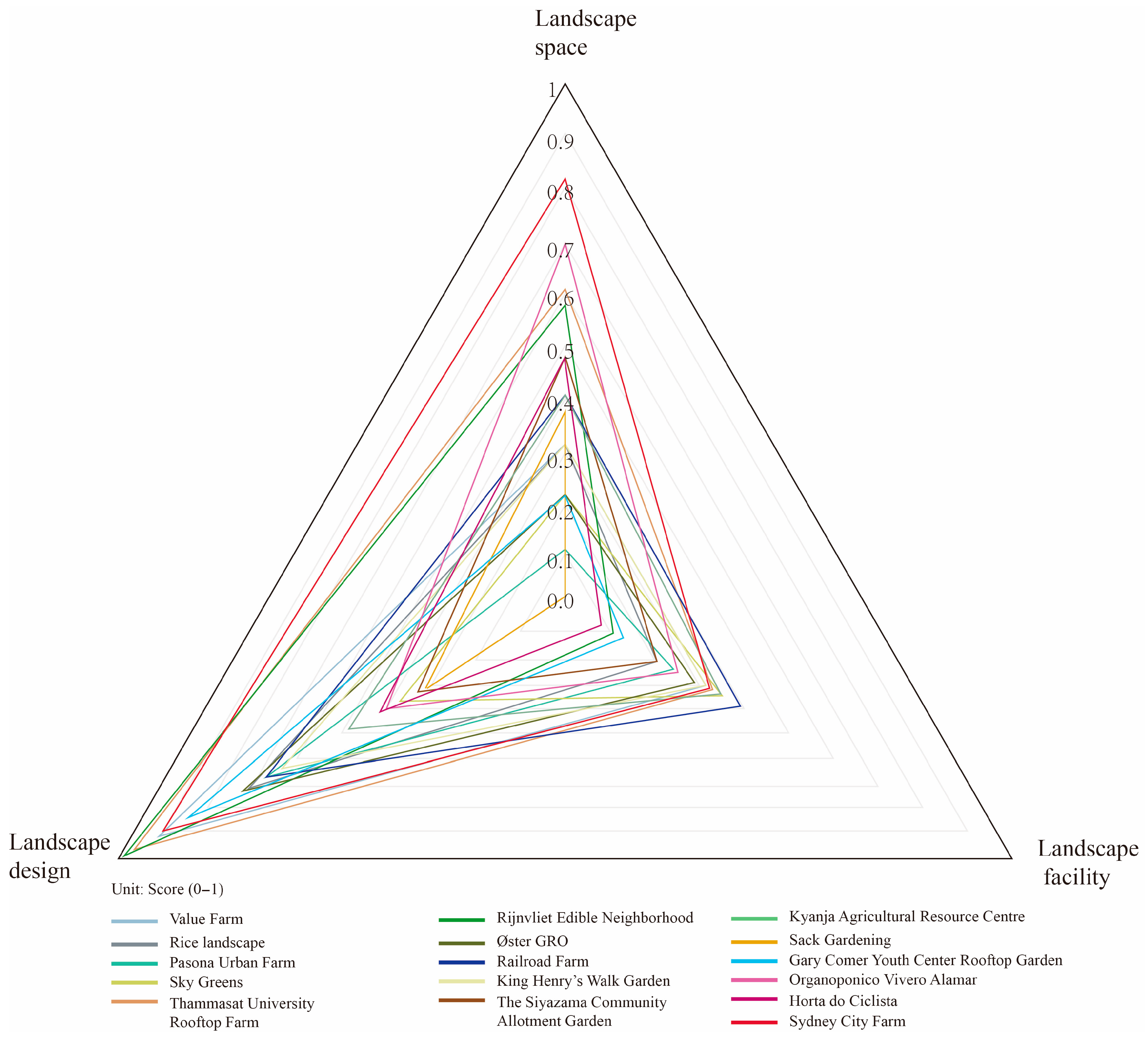
Figure 3 shows a radar graph that provides a visual representation of the scores of each dimension. Table A1 in the Appendix A presents the scores of each case for the indicators of the landscape design, landscape space, and landscape facilities dimensions. The radar graph shows that landscape design received relatively high scores. Sydney City Farm had the highest overall score (2.06) and the highest landscape space score (0.82). Sack gardening in the Kibera slum had the lowest total score (0.7). Regarding landscape design, Rijnvliet Edible Neighborhood received the highest score (0.99). Regarding landscape facilities, La Ferme du Rail had the highest score (0.39). The following provides a detailed description and analysis of each case.

3.1. Case Studies

3.1.1. Europe

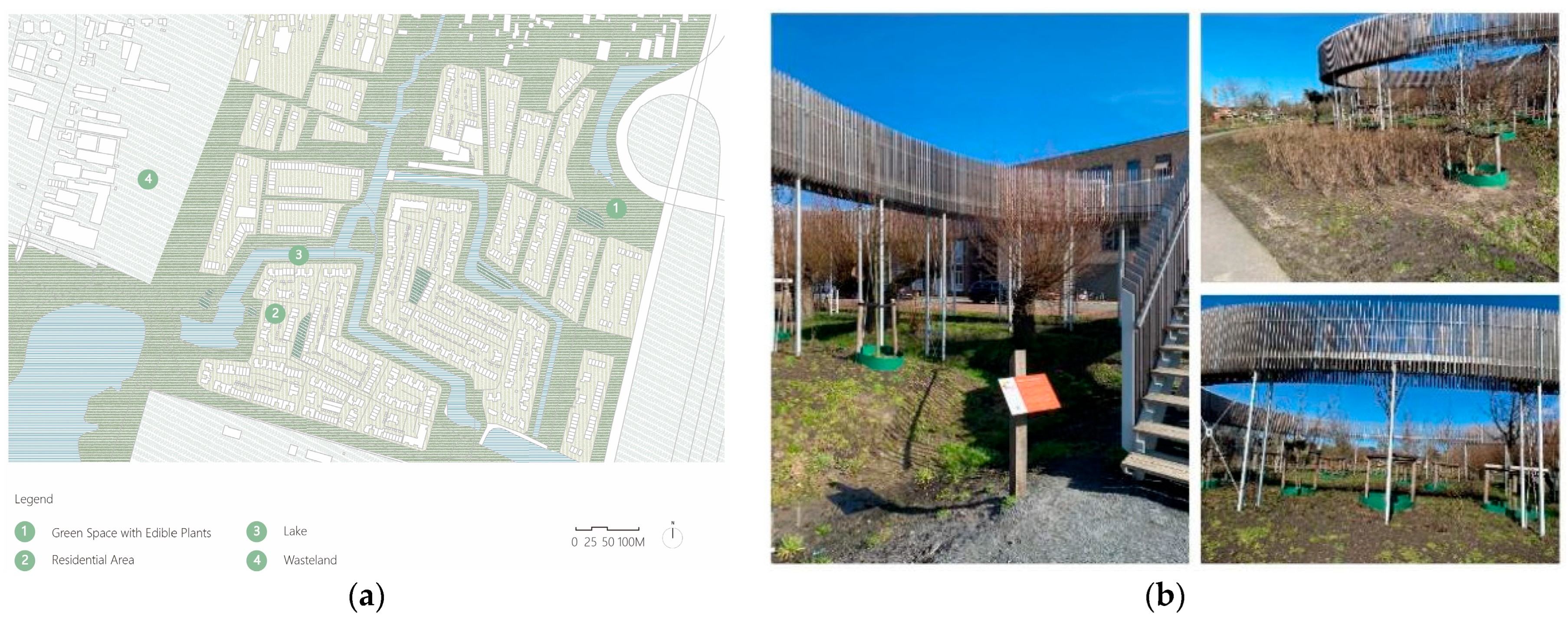
The Rijnvliet Edible Neighborhood is a new neighbourhood under construction in Utrecht, the Netherlands. It is considered the first “Edible Neighbourhood” in Europe. The project covers about 44 ha, and it includes avenues and streets lined with fruit trees, recreational areas, and a 15 ha public UA orchard called “Food Forest” [31] (Figure 4a). The core innovation of this project is that it achieves harmonious integration with the macrocosm of nature.
In the landscape design dimension, this case achieved the highest score (0.99) among all compared cases due to its high natural landscape (0.8) and landscape expression (0.89) scores. Rivers run through the project area, and edible plants are layered to facilitate seamless integration with the natural environment. Its central landscape feature is an installation called “Closer to Trees”, comprising apple trees and a circular wooden footbridge about 4 m tall [32] (Figure 4b). Visitors are able to delve into the canopies to observe the development of buds, leaves, flowers, and fruits in different seasons. This improves the project’s interactivity. Additionally, the naming of roads and the marking of houses with plant names make the landscape interesting. These elements contribute to the project’s outstanding landscape expression.
Regarding the landscape space dimension, the project adopts an axial layout with integrated spatial functions. Meanwhile, it is one of the few UA projects that fully and harmoniously integrates green space, blue space, and city in an urban context [33]. Therefore, it achieved a relatively high score in the spatial dimension (0.58).
In the landscape facilities dimension, the project scored lower (0.11). This is because it avoids the use of complex agricultural techniques in order to emphasise the natural growth processes of plants. The selection of low-maintenance species further minimises human intervention and optimises natural dynamics. However, its planning of infrastructure is evident in the provision of explanatory signage and leisure seating.
Railroad Farm, built in 2020, is the first UA polyculture farm in Paris, France. The project covers an area of about 1370 m2, and it includes a community vegetable garden with an area of 340 m2, a rooftop vegetable garden with an area of 190 m2, terraces, a restaurant, a filter basin, a composting area, and a production greenhouse with an area of 185 m2 [34] (Figure 5a,b). The core innovation of the project is that it combines several types of UA, such as permanent agriculture, aquaponics, and vertical farming.
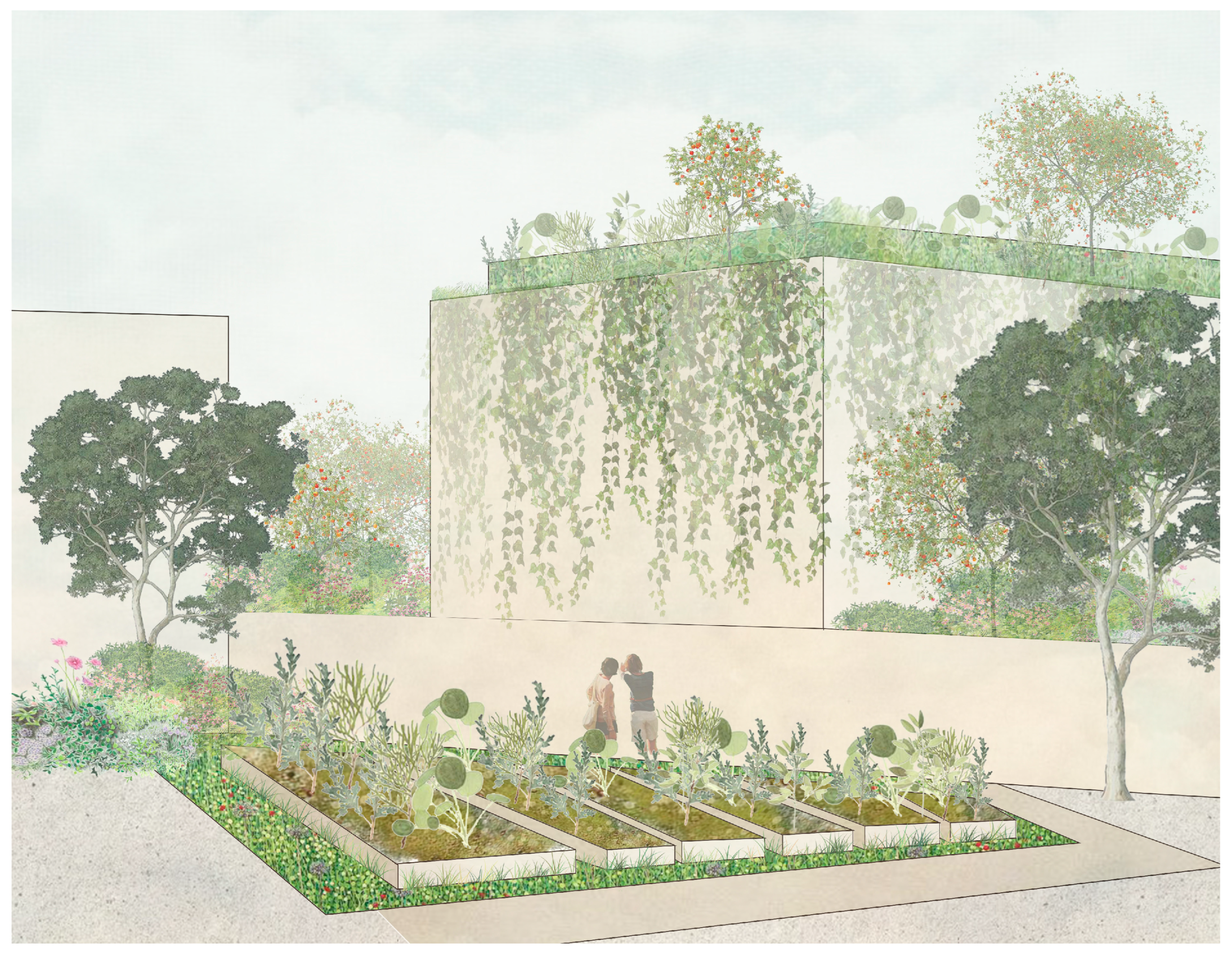
Regarding the landscape design dimension, it uses elements such as ramps, terraces, and vertical planting to soften spatial contradictions and add interest (Figure 6). The wonderful landscape performance derived from the multiple forms of agriculture favours its landscape design score (0.68).
Regarding the landscape space dimension, the project is situated within a relatively enclosed space with walls, which reduces its landscape space score (0.41). However, its commercial restaurant is well connected to the external environment and is visited by outsiders, thereby improving spatial accessibility [34].
Regarding the landscape facilities dimension, the project achieved the highest score (0.39) due to its comprehensive infrastructure and intelligent composting technology. Most noteworthy is the project’s perfected mechanised composting facility, designed to achieve large-scale, efficient, and regulated mass production of compost. For example, 20 tons of organic waste were collected to make compost in 2020 [34].
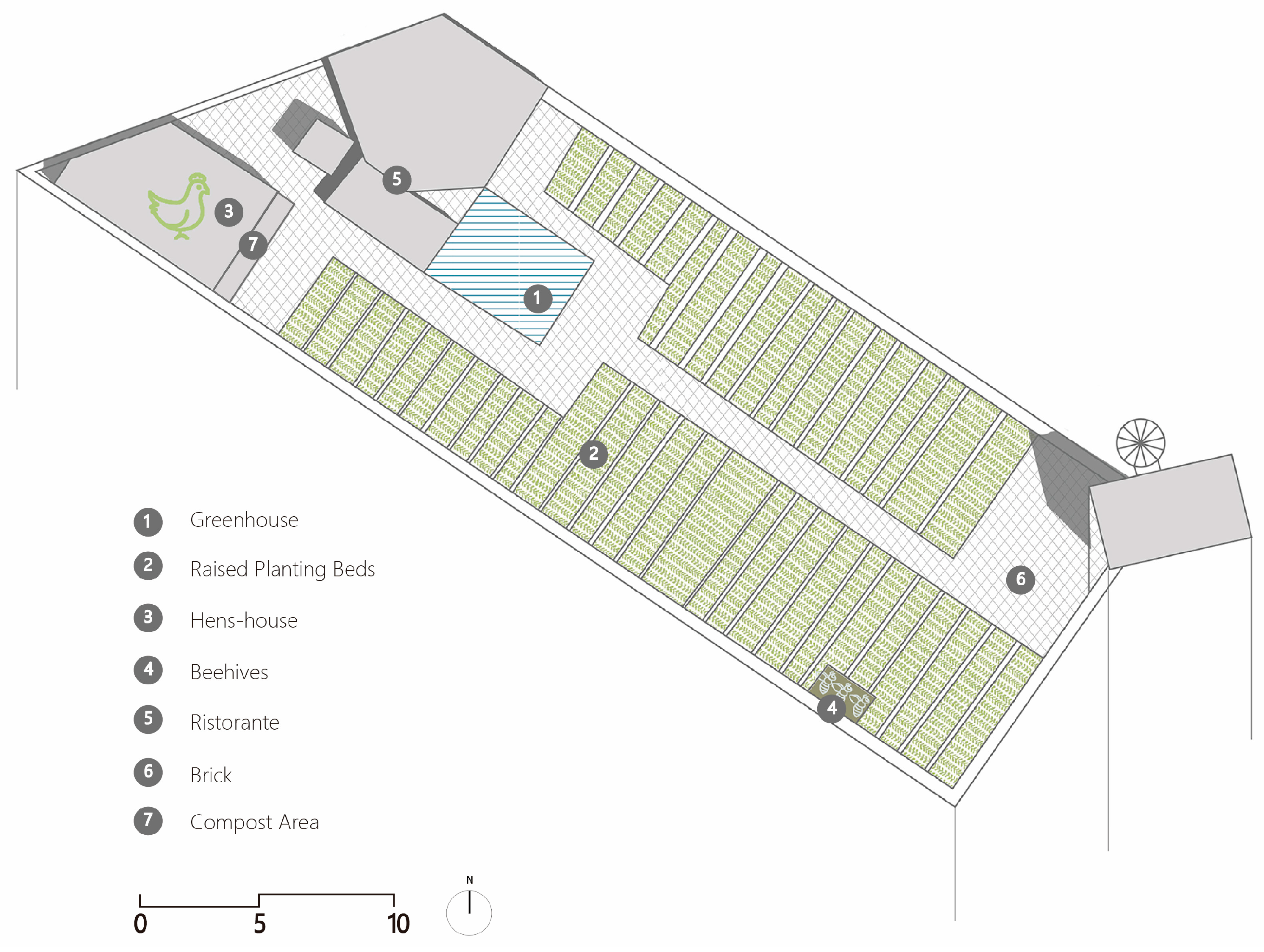
Øster GRO is located on the rooftop of a secluded office building in the Østerbro neighbourhood of Copenhagen, Denmark. It is the first rooftop UA in Copenhagen [35] (Figure 7). It covers an area of 600 m2, consisting of raised planting beds with a 30 cm depth, a 40 cm width, and a total surface area of 350 m2; a chicken house; three beehives; a farm equipment room; and a greenhouse with an area of 28 m2 and an attached kitchen [36]. Its core innovation is reflected in the highly intensive utilisation of its landscape space. Within a limited area, the project integrates crop cultivation, livestock farming, and food processing spaces.
In the landscape design dimension, the project scored highly on the “natural landscape” indicator (0.6) but poorly on the “artificial landscape” indicator (0.2). This stems from three factors: (1) The project eschewed complex design forms. It centres on a footpath axis flanked by planting beds, culminating in a design-driven glass greenhouse. (2) The project lacks innovative landscape installations. Nevertheless, the abundance of edible plants creates a natural atmosphere. (3) The project includes a variety of agricultural activities, such as growing vegetables, fruits, and herbs and feeding poultry and bees [37]. Furthermore, safety issues reduced its landscape performance score (0.44). The primary concern is that the spiral staircase leading to the roof is narrow and lacks anti-slip measures, presenting a significant safety hazard.
Regarding the landscape space dimension, the design uses a simple axial layout. Its overall structural arrangement is simple and compact. Due to the limited available space, its functional areas overlap. The greatest limitation in this case is the lack of connection between the concealed roof and the outside. This results in the lowest spatial identity score (0).
Regarding the landscape facilities dimension, the project’s infrastructure is relatively comprehensive, including a greenhouse, signage, and leisure seating. Additionally, the project’s planting functions are supported by technical agricultural facilities such as a drip irrigation system.
King Henry’s Walk Garden is located behind a playground in Islington, North London, UK. It is a sustainable community allotment garden rebuilt from disused park space, and it opened to the public in 2007 [38]. King Henry’s Walk Garden covers an area of about 1633 m2, comprising a community plot area, woodland areas, a pond with a low bridge, a public leisure area, and an agricultural support facility area [39] (Figure 8). It is intended to promote biodiversity, as well as provide opportunities for residents without private gardens to enjoy planting [38].
Regarding the landscape design dimension, its landscape comprises interwoven aquatic plants, agricultural crops, and tall trees, obtained by protecting woodlands, constructing ponds, and demarcating private plots. Furthermore, it presents a thought-provoking natural landscape. This is intuitively reflected in its high natural landscape score (0.6). Meanwhile, the artificial water landscape contributes to the site’s unique aesthetic atmosphere, adding points to the artificial landscape score of the project. However, its landscape performance score (0.33) is constrained by fixed opening hours and a strict membership system.
Regarding the landscape space dimension, the project adopts a centralised layout with the integration of partial functional spaces. Due to the impact of surrounding walls on its permeability and accessibility, its spatial identity score (0.25) is relatively low.
Regarding the landscape facilities dimension, it possesses comprehensive infrastructure, including buildings, interpretive signage, and seating, as well as robust technical facilities, such as rainwater harvesting systems and public buildings. Therefore, it achieves a high landscape facilities score (0.32).

3.1.2. Australia

Sydney City Farm is located in Sydney Park, Alexandria, an inner-south suburb of Sydney, Australia, covering an area of 1200 m2. It consists of three components: a farm storage building and nursery, a farm orchard, and a community centre and planting area. The planting area mainly consists of planting beds, including plots and planters. Its core innovation is the construction of an urban agricultural demonstration base integrating production, education, and social functions while providing residents with an opportunity to connect with nature [40].
In the landscape design dimension, it achieved the third-highest score (0.90) among all cases compared, with the highest score (0.8) awarded for the artificial design. The scores for natural landscape (0.67) and landscape presentation (0.77) were also excellent. It mimics the garden design approach, featuring different planting themes, such as bee pollinator, tropical plant, and native crop areas, to demonstrate a variety of planting techniques [41]. Moreover, movable planting beds serve as landscape modules capable of creating diverse UALs. As part of an open park, the project is integrated with the park environment, and people are allowed to visit at any time [42].
In the landscape space dimension, the project achieved the highest score (0.82). Its spatial layout is relatively complex, with the integration of functional spaces.
Regarding the landscape facilities dimension, the project has ample agricultural tools and an efficient irrigation system. At the same time, the community centre, bench-style planting beds, farm storage, and diverse signage complete the project’s infrastructure [40].

3.1.3. North America

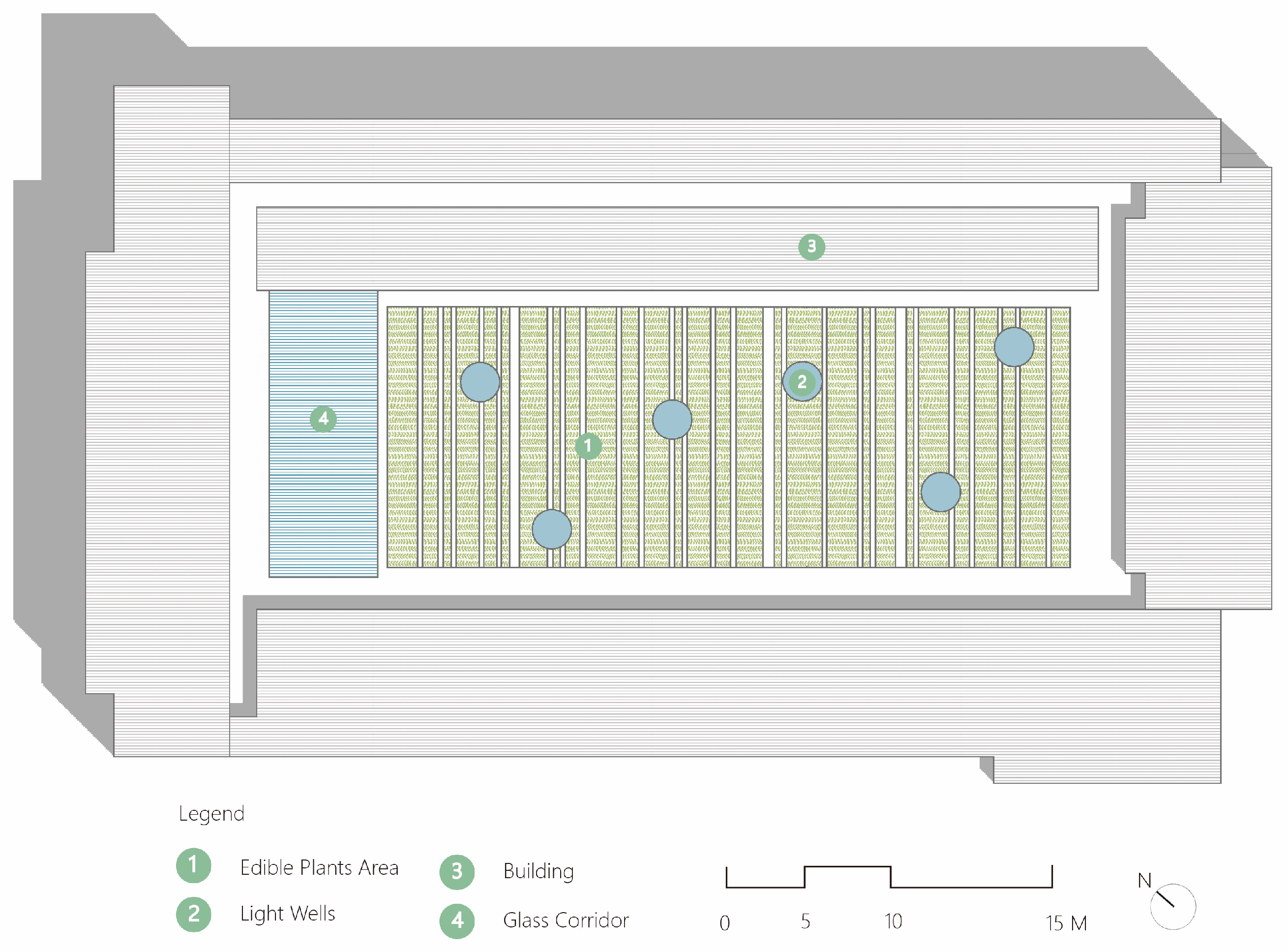
The Gary Comer Youth Center Rooftop Garden is located on the rooftop of Gary Comer Youth Center in the Greater Grand Crossing neighbourhood on Chicago’s South side, USA [43]. The project covers an area of 758 m2, with 538 m2 of cultivated land [44]. The roof garden is situated in the atrium and comprises multiple rectangular planting beds and six circular light wells. The Professional Awards Jury of the American Society of Landscape Architects (ASLA) praised this project in 2010: “This project is so simple and straightforward and is clearly a good collaboration between landscape architect and architect. It is redeeming [43].” The project reinvents the aesthetic value of vacant urban spaces while providing educational and productive activities and achieving the functional integration of spaces.
In the landscape design dimension, the project’s unique design secured the highest score for landscape expression (1) and the second-highest score for artificial landscapes (0.6). The interlaced design layout of rectangular plots of different sizes and six giant circular metal light wells breaks the inherent boundaries of the space and endows it with spatial efficiency (Figure 9 and Figure 10). Meanwhile, circular light wells are evenly scattered in the garden, establishing a connection between the interior and rooftop garden while being used as an artistic element of the design. The project’s paths are aligned with the surrounding window frames, allowing for their continuation and increasing the sense of extension.
Regarding the landscape space dimension, it is located inside a building and has no external entrances, lacking connections to the external environment and people. This explains why the project achieved the lowest score in spatial identity (0).
In the landscape facilities dimension, it obtained the highest technical facilities score. The project is equipped with a complete water circulation system for irrigation and drainage; a rainwater collection system feeds the irrigation system of the planting beds instead of discharging precious resources into the sewers [44]. However, due to the enclosed and narrow site, the project does not include landscape infrastructure such as seating.
Organoponico Vivero Alamar (OVA) is located Alamar, a district east of Havana, and it covers an area of 11.2 ha. It is one of the largest and most successful urban agricultural projects in Cuba [45]. OVA consists of a nursery, a greenhouse with an area of 0.45 ha, a laboratory, a fungus breeding centre, a small agro-industry, and an organic fertiliser production centre [45]. The project’s most unique feature is the adoption of a non-mechanical production model to achieve fully organic production, offering inspiration for the sustainable development of UA.
In the landscape design dimension, the project achieved a high natural landscape score (0.67). The main reason for this is the project’s diverse range of production types, including fruit trees, vegetables, grain crops, cattle, and rabbits. At the same time, the rich planted landscape elements and simple functional divisions simulate a more natural landscape expression. However, due to the project’s excessive emphasis on natural elements and lack of creative landscape elements, it received the lowest score for artificial design, which affected its overall landscape design score (0.4).
Regarding the landscape space dimension, the project did not involve the construction of perimeter walls or paving. The project’s extensive agricultural spaces and unpaved roads are interwoven with the external natural environment. This is the reason why it received the second highest score (0.70) in landscape space.
Regarding the landscape facilities dimension, it uses non-mechanised traditional cultivation methods to achieve a seamless integration of diverse agricultural techniques with the natural landscape. However, the absence of infrastructure such as seating and signage at the vast site decreases the project’s functional value.

3.1.4. South America

Horta do Ciclista is located under a monument garden, which is in the middle of the most famous street—Avenida Paulista—in the centre of Sao Paulo, Brazil [46]. The garden is small, about 60 m2, with some trees planted on the right side, and edible crops planted on the left side. The paths in the garden comprise wider radial and spiral paths, making it convenient for people to reach each of its areas. It is one of the most representative examples of community agricultural gardens managed by an online network in Sao Paulo.
In the landscape design dimension, it scored relatively low (0.42) among all samples, with its natural landscape receiving the lowest scores. This is primarily due to the site’s narrow spatial constraints limiting plant diversity. However, the interesting pathway and convenient geographical location enhance its attractiveness and participation, resulting in a higher landscape performance score (0.66).
Regarding the landscape spatial dimension, it is a fully open participatory public garden [46]. Its advantageous location facilitates the creation of multifunctional spaces. The narrowness of the site leads to overlapping spatial functions. This explains its higher spatial identity score (0.75).
Regarding the landscape facilities dimension, the limited space precludes the need to design infrastructure. Consequently, its landscape facilities score (0.08) is low.

3.1.5. Africa

The Siyazama Community Allotment Garden Association (SCAGA) is located in one of the poorer neighbourhoods of Khayelitsha, Cape Town, South Africa. It is also known as the “Power Lines Project” because it is built on unused land under power lines [47]. It is a typical model of a community food garden and has become a leader in Cape Town’s micro-scale UA [47]. The SCAGA covers an area of 5000 m2 and is composed of planting beds, greenhouses, a small-scale nursery, a craft group, and a soup kitchen [47]. The core innovations of the project are that it provides effective assistance to vulnerable groups and fully utilises underused land.
Regarding the landscape design dimension, the diverse species of edible plants provide a means of obtaining high-yield, nutritious crops. However, the project’s lack of interesting and interactive design resulted in its landscape performance achieving the second-lowest score (0.33) among all samples. At the same time, as the development goals primarily focused on survival needs, the project did not incorporate paving or artistic expression. This resulted in it receiving the lowest score (0) in the artificial landscape dimension.
Regarding the landscape space dimension, the project demonstrates high permeability and accessibility. It adopts fencing to define the site boundaries, maintaining a degree of connection with the external environment. Meanwhile, the project demonstrates efficient spatial utilisation. Its community hall serves both as a space for communicating agricultural techniques and as a chapel during leisure hours [48].
Regarding the landscape facilities dimension, the project incorporates a biodigester that turns garden waste into liquid fertiliser, while fuel is supplied to the kitchen by using a pump to transport methane gas [48]. It not only possesses comprehensive agricultural cultivation facilities but also integrates intelligent agricultural systems to advance sustainable farming practices. Therefore, it achieved the highest technical facilities score (1).
Sack gardening covers an area of 2.5 km2 in the Kibera slum, the largest slum in Nairobi, Kenya, and East Africa [49]. Sack gardening is a major form of UA in the Kibera slum due to poverty, a lack of resources, and limited space [50]. Constructing a sack garden is simple and cheap. People simply fill a nylon mesh bag with soil and gravel, cut a slit in the side, and place seeds inside. The project has the lowest overall score for landscape quality, but it is one of the main methods of survival for slum residents. According to research by Gallaher et al. (2015), residents in the Kibera slum use sack gardening for 1.6 years on average [51]. Its core value is that it creates mobile landscapes, thereby enhancing urban infrastructure and unifying fragmented urban spaces.
In the landscape design dimension, it achieved the lowest score (0.33) due to the following three reasons: (1) plant types are limited due to the use of planting containers, with common vegetables mainly being cultivated; (2) the project aims to improve the lives of disadvantaged groups, with its expressive form and purpose influencing its aesthetic creation; and (3) the project prioritises survival needs over landscape expression such as interestingness.
Regarding the landscape space dimension, the project lacks a unified layout and multifunctionality. However, due to its volumetric advantages and the spatial constraints of its environment, it is typically situated in public places in common areas such as roadsides, open spaces near houses, near rubbish dumps, and near toilets [51]. Thus, it possesses a degree of permeability and accessibility.
In the landscape facilities dimension, its score ranks lowest among all samples. Its simple structure and dispersed locations underline the inability to develop infrastructure. Additionally, due to the lack of a comprehensive and formalised water supply system, technical facilities cannot be constructed [51].
Kyanja Agricultural Resource Centre is located in Kyanja, a parish north of Kampala, Uganda. The project occupies an area of about 120,000 m2 and has established six large units: a micro-gardening unit, a greenhouse unit, a vermiculture unit, an aquaponics unit, a livestock breeding unit, and a poultry farming unit [52]. Its core innovation is the use of multiple agricultural units to demonstrate urban farming techniques to local residents and clarify their vital role in ensuring food security.
In the landscape design dimension, the project achieved its landscape expression score due to the various design expressions used in the different units. Among these, the micro-horticultural units use micro-containers such as flowerpots, tyres, and wooden crates to cultivate crops, creating an engaging landscape presentation [53]. However, the project’s focus on UA training and promotion resulted in a lack of designs of artistic or conceptual merit. This led to lower scores for both the natural and artificial landscape dimensions.
Regarding the landscape space, its production units are relatively isolated, reducing internal spatial connectivity. This separate environment also impacts the project’s spatial identity score.
Regarding landscape facilities, the project scored higher (0.36). It not only establishes greenhouses as UA infrastructure but also uses innovative agricultural techniques to achieve resource recycling, such as aquaponics [53].

3.1.6. Asia

Pasona urban farm was located at the Pasona headquarters in Otemachi, a district in Chiyoda, Tokyo. It was an integrated UA project incorporating rooftop farming, vertical farming, and in-building farming, and it had become the largest from farm-to-table project in an urban office in Japan [54]. However, it has permanently closed due to the relocation of the headquarters. The project had a cultivation area of over 4000 m2. It incorporated rooftop gardening, vertical gardening, and indoor agriculture [54] (Figure 11). Its greatest innovation was the creation of spaces where humans, architecture, and agriculture coexisted through indoor cultivation, enabling a model that integrated production, life, and habitation.
Regarding the landscape design dimension, the project provided new inspiration for interior design. The edible plants became interior decorative landscaping. According to Kono’s design, tomatoes hung above the meeting table; passion fruit and lemon trees were used to partition spaces; bean sprouts were cultivated under benches; and rice fields and broccoli areas were set up in the auditorium [55]. Therefore, it received a high landscape performance score (0.77).
Regarding the landscape space dimension, the project’s diverse functions were superimposed and integrated within the same space. Due to the obstruction of building walls, it failed to establish connections with the external environment. Consequently, its landscape space score is the lowest among all samples (0.12).
Regarding the landscape facilities dimension, the project demonstrates outstanding performance, particularly in the application of technical installations. It used metal halide lamps and high-pressure sodium vapour lamps for plant cultivation [55]. Meanwhile, an intelligent climate control system was used to manage crops [54,55]. These technical installations promoted innovation in indoor UA and enhanced public awareness of it.
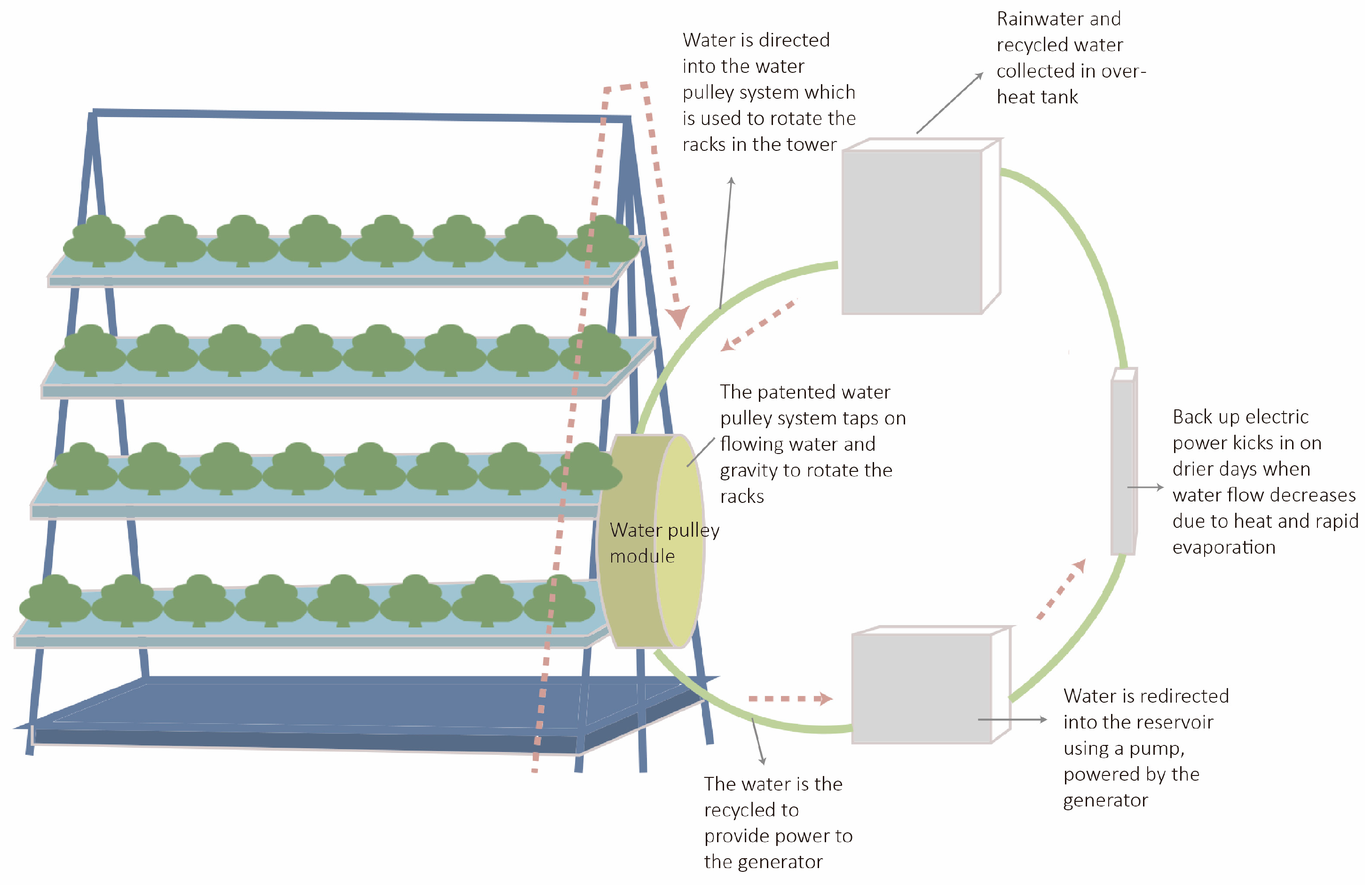
Sky Greens is a high-technology vertical UA farm located in Lim Chu Kang, the agricultural centre of Singapore [56]. It is the first commercial vertical urban farm to utilise A-Go-Gro hydroponics in Singapore and the first low-carbon, water-driven hydraulic vertical farm in the world [56]. Sky Greens covers an area of 40,000 m2, with a number of greenhouses. Each greenhouse is 24 m long and 8.5 m wide and can accommodate six plant towers [57]. A plant tower occupies only 5.5 m2, which is easy to produce, maintain, and manage [58]. Its core innovation is the achievement of efficient urban agricultural production through innovative agricultural techniques, providing a reference model for mobile vertical agricultural landscapes.
In the landscape design dimension, the project scored relatively low (0.37). This stems from its focus, as a productive initiative, on the farm’s production capacity. Artificial landscape factors such as creative design and landscape expression factors such as participation are not the project’s emphasis. The modular plant towers adopted by the project can become unique artistic landscapes in specific environments. Further, the modules can form a unified, spectacular vertical urban agricultural landscape.
In the landscape space dimension, the project also scored low overall among all samples. Its fully enclosed commercial cultivation model results in isolation from the external environment. Meanwhile, the project lacks complete openness; it is only open for visitor tours on Saturday mornings [56].
In the landscape facilities dimension, the project achieved a relatively high overall score (0.36). It has advanced technical UA facilities, including multiple plant towers utilising A-Go-Gro hydroponic technology. The plant tower consists of 38-layer rotating planting racks that rotate very slowly using a hydraulic shelf-rotating system powered by a gravity-aided water pulley system [57,58] (Figure 12).
Thammasat University Rooftop Farm (TURF) is located in Pathum Thani, Thailand. It is the largest urban rooftop farm in Asia. TURF covers a green roof area of about 22,000 m2, including 7000 m2 for UA [59]. The project is composed of terraces, rooftop amphitheatres, and 12 oval platforms [60] (Figure 13). The project demonstrates ways to improve the utilisation of valuable natural resources. Further, it realises the integration of landscape and technology and refines the idea of design in the service of UA.
In the landscape design dimension, the project achieved the second-highest score (0.96). This is intrinsically linked to its outstanding performance in artificial design. The project elaborates on the design concept of its H-shaped layout. The “H” represents “Humanity”, which symbolises the egalitarianism and democracy of the university [61]. Additionally, the aesthetic value of the project is emphasised by its uniquely designed planting beds and artistic terraces.
Regarding the landscape space dimension, the project integrates square and axial spatial layouts. As a rooftop garden, it maintains connectivity with the external environment. Its terraced design facilitates the integration of the roof with the surrounding landscape, therefore achieving a high spatial identity score (0.75).
In the landscape facilities dimension, the project secured a high overall score due to its innovative water circulation system. Each terrace is equipped with rainwater retention lawns and runoff drainage channels to facilitate the downward runoff of rainwater into micro-watersheds, while multiple layers of plants and soils are used to absorb, filter, and purify the rainwater [60,61].
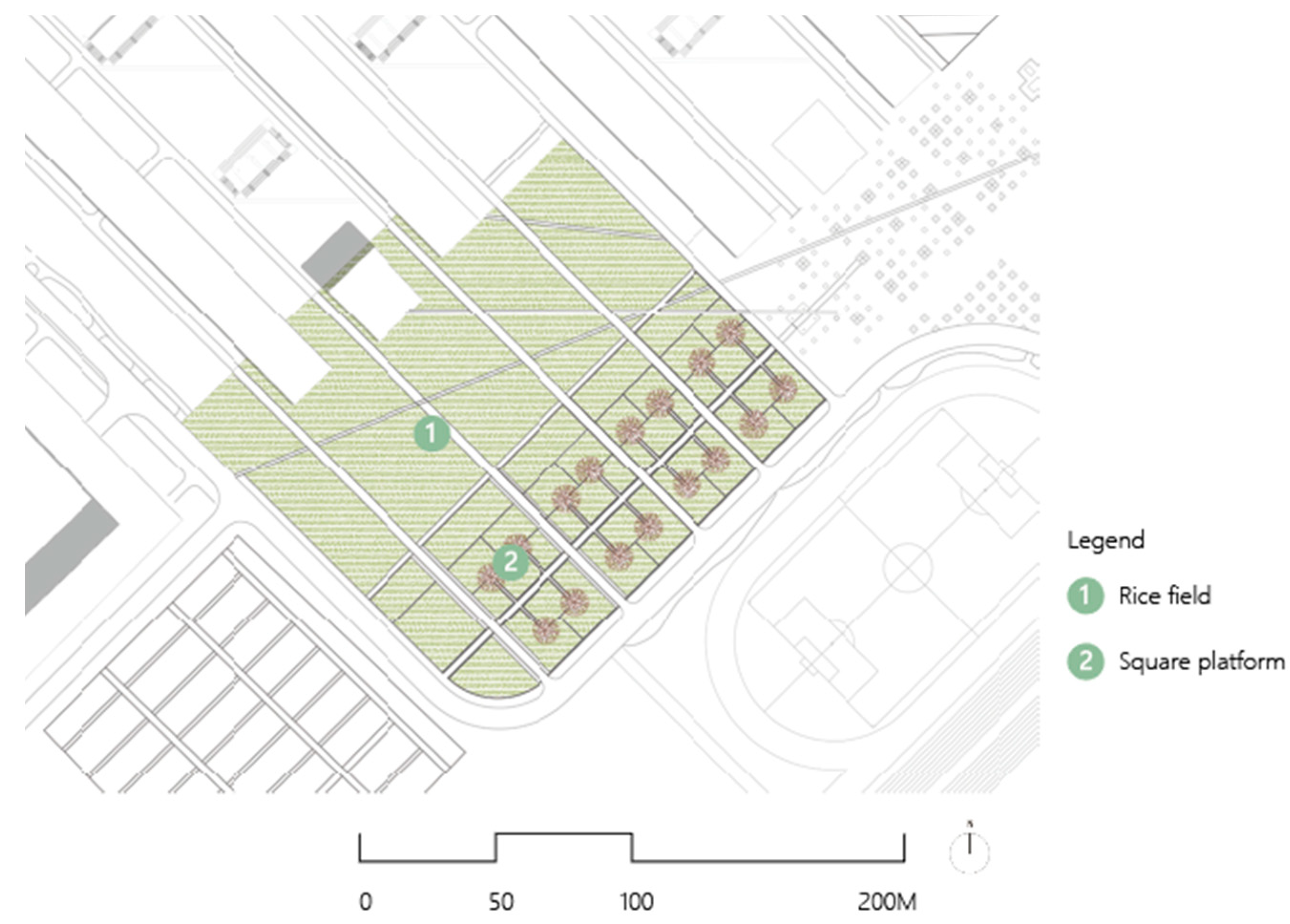
The rice landscape project is located at Shenyang Architectural University in Shenyang, China, and it covers an area of 21 ha [62]. In 2005, the project received the Honor Award of ASLA [63]. The rice landscape project consists of groups of five rectangular rice fields of a similar size, each divided by roads into many smaller fields of different sizes [63] (Figure 14). In each group, a square platform surrounded by grey stone benches is designed for students to study and rest. Its core characteristic is the creation of a unique urban agricultural landscape through the cultivation of a single plant species.
In the landscape design dimension, the project obtains a low natural landscape score (0.4), a relatively high artificial landscape score (0.6), and a high landscape performance score (0.77). There are four reasons for this: (1) Only a single planting variety is used—rice. (2) It possesses a distinctive artistic design. It breaks up the regularity of the space by using straight roads to cut the plane, making the site rich in terms of design. (3) It expresses traditional Chinese farming forms through multiple rectangular rice fields [63]. (4) Rice is used to present different scenes in four seasons, creating an engaging landscape [63].
In the landscape space dimension, the project’s overall score is low (0.32). This stems from the disparity between the cultivated environment and its surroundings, which diminishes spatial accessibility and permeability.
Regarding the landscape facilities dimension, the project incorporates an underground water circulation system to manage crop irrigation. During periods of insufficient rainfall, the urban water supply system provides irrigation water for the rice fields; conversely, when precipitation exceeds 700 mm, surplus rainwater is promptly discharged via the municipal drainage network [63].
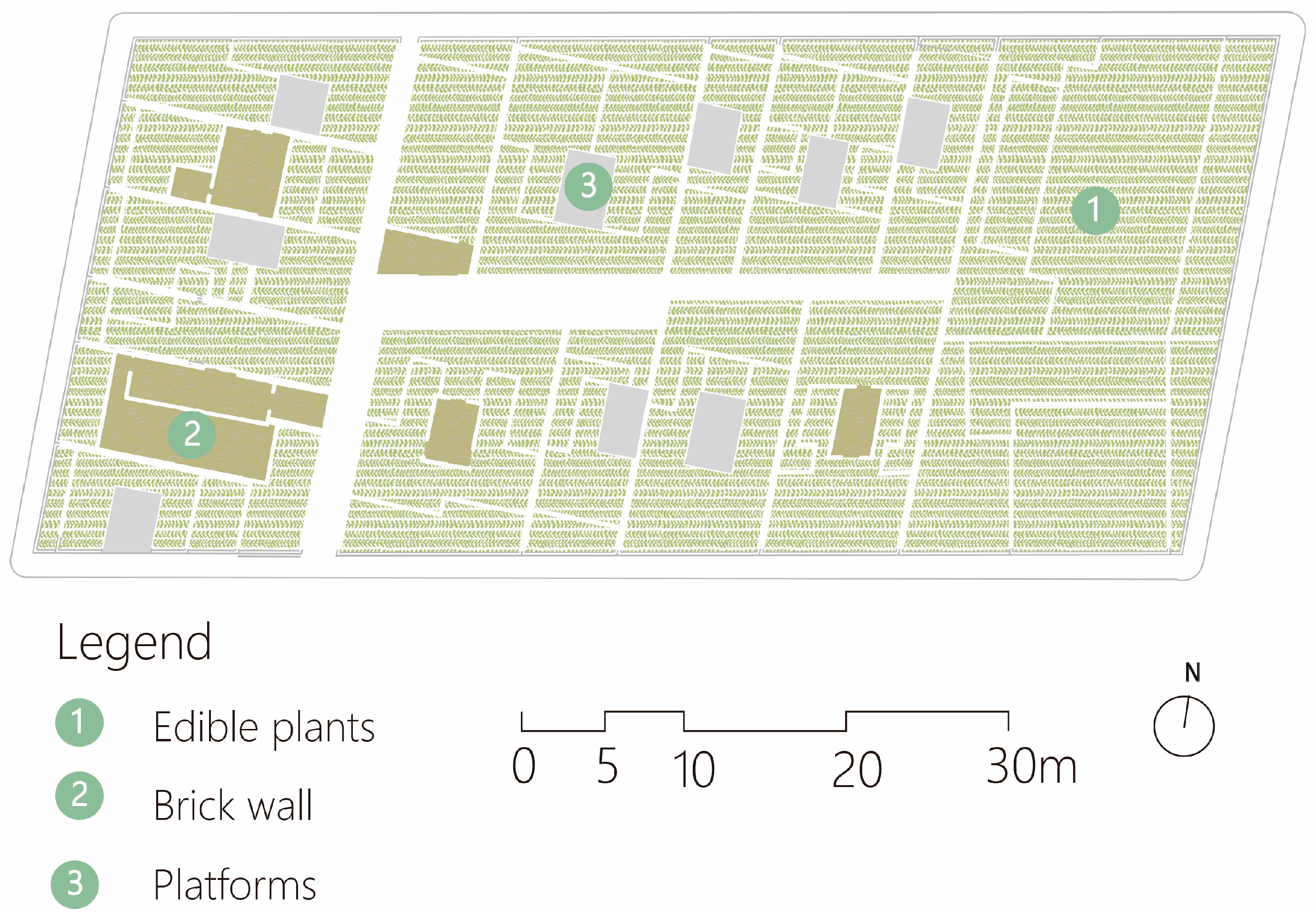
Value Farm is located at Guangdong Glass Factory in Shekou, Shenzhen, China, and it covers 2100 m2 [64]. It is a part of the Hong Kong and Shenzhen Bi-City Biennale of Urbanism Architecture 2013 [64]. The project mainly consists of brick walls, several planting beds of different heights, four platforms, and open pavilions, as well as a nursery, an exhibition area, and a projection room to enhance the understanding of agriculture [65] (Figure 15).
Regarding the landscape design dimension, the project makes the garden culturally and historically significant through a unique design that mimics and echoes the rooftop structures of the densely populated central city. Its design concept comes from the combination of rooftop agriculture in Hong Kong and changes in the original structure of the historic city centre [65]. Further, the colours of the plants are used to create complementary and contrasting landscapes. The combination of planting beds, platforms, and pavilions gives the design a sense of layering and interest. These factors explain its high landscape design score (0.91).
Regarding the landscape space dimension, the project adopts a square spatial layout with the integration of partial functional areas. As it is located at a semi-enclosed industrial site, permeability and accessibility are constrained, reducing its spatial identity score (0.25).
Regarding the landscape facilities dimension, the project includes comprehensive infrastructure, such as seating adjacent to planting areas, a nursery, and a projection room. Additionally, it incorporates a water collection basin and an irrigation system to conserve water resources.

4. Discussion

This study demonstrates that landscape quality is closely related to landscape design, space, and facilities. By exploring the samples, I summarise the characteristics of each dimension and propose feasible strategies to improve landscape quality in urban agriculture projects.

4.1. Landscape Design

By analysing the samples and data, this study explores detailed methods of landscape design according to the dimensions of natural landscapes, artificial landscapes, and landscape performance. The proportions of design and natural elements in a project determine the performance of landscape design. It is concluded from the data that most projects use a combination of artificial and natural designs for landscape expression, namely, UA gardens with productive plants and an aesthetic design. However, each case has a specific focus. In this study, UA projects are subdivided based on the landscape design method as follows: UA projects that focus on a natural design approach emphasising a casual or recreated naturalness and UA projects that predominantly focus on an artificial landscape approach incorporating a designed space and formal layout.
UA projects that focus on a natural design approach focus on botanical elements, including aquatic plants, crops, and ornamental flowers. The designers create a landscape that imitates nature by combining different types of plants such as fruit trees, herbs, spices, and vegetables. Variations in the height, colour, and smell of the crops, combined with the distinctive shapes of their branches, leaves, flowers, and fruits, create a multi-dimensional, natural, and unique landscape engaging the senses of sight, taste, and smell. This type of UA project is characterised by a wide variety of plants and natural features.
UA projects that are predominantly composed of artificial landscapes focus on the expression of the project concept through artificial design, showcasing the creativity and artistry of the site.
The main design methods include the following: (a) Giving the project design conceptual, cultural, and historical significance. Designers use creative design approaches to express the uniqueness of the project, as well as the concept. (b) Designing artistic landscape installations. This can improve the atmosphere of the UA project and increase its artistic value and attractiveness. Landscape installations can be used as project landmarks or symbols. Designers can adopt a decentralised layout to embed landscape installations in different thematic areas. Meanwhile, designers can also use landscape installations as visual centres to organise the overall space of the project. (c) Using movable landscape modules to compose landscape designs with variability. This approach can be used in high-density urban spaces and interstitial spaces, aiming to improve and connect fragmented urban spaces.
Landscape performance is also one of the most important factors in determining the quality of landscape design. Participation is the cornerstone of project sustainability. A variety of landscape designs increase interest in the project and motivate residents. Fun stimulates exploration of the project and raises awareness of agricultural concepts. Designers can enhance residents’ senses of smell, touch, taste, and sight by planting edible plants with different colours, smells, touches, tastes, and shapes. The design must comply with local policy requirements. It is also important that the design considers safety according to different needs and the use of safe, non-hazardous materials.
Moreover, a comparative analysis of the selected samples indicated that certain artificial design practices demonstrate higher levels of community participation than natural designs. There are two primary reasons for this: On the one hand, most artificial design projects incorporate interactive and creative landscape installations. These unique landscape installations serve as project landmarks, increase residents’ attention, and enhance the site’s artistic atmosphere. Meanwhile, they attract active participation by providing opportunities for interaction. For example, the Value Farm design interactive platform stimulates resident engagement. On the other hand, some of the artificial designs incorporate design concepts and create innovative spaces. Rational design allows for an attractive environment to be created. At the same time, it promotes residents’ experience and stimulates people’s exploration of the project.
Further examination revealed that, in some cases, the aesthetic design was the focus. This is closely related to the demands of urban public spaces. However, aesthetic and functional elements are not inherently contradictory. Aesthetic elements can provide sensory experiences and promote public engagement. Functional elements possess both productive and educational value while also serving to provide a unique landscape. These aspects often intertwine and influence one another. Design approaches can synthesise their respective characteristics. Designers can select edible plants that offer both visual appeal and educational value, and, at the same time, they can use artistic installations to skilfully integrate aesthetic and functional elements. Through such methods, UALs can simultaneously ensure food security and enhance the aesthetic value of the space.

4.2. Landscape Space

The landscape space is another indicator of landscape quality, mainly considering the spatial layout, spatial function, and spatial identity. The spatial layout creates the overall atmosphere of the space and can fully reflect the understanding and awareness of the project. It was concluded from the samples that a square space layout is the main spatial layout used. Designers can use a number of square spaces in combination with each other to fill and form the overall space. A square layout provides a cluttered area with spatial order and regularity, and it adds spatial interest. Some samples also use an axial spatial layout. This is mainly used in projects containing multiple flexible spaces. A centralised spatial layout is used the least. This emphasises the centripetal and malleable features of the project. In each sample, a central area is mainly created to showcase the most exciting and important elements of the project.
The samples mostly adopted two types of layouts for spatial functions: (1) a layout where multiple spatial functions overlap each other and (2) a layout where part of the space is integrated and part of the space is independent. Research shows that the first type is mainly used in projects with small areas and relatively closed spaces. This approach improves the utilisation and interest of the space. The latter type is mainly realised through creative landscape planning and design. It is also facilitated by the size of the space and the specificity of the landscape, such as the presence of plants that require a unique environment and the project concept.
Among the case studies explored, certain cases demonstrated low spatial identity scores. In these cases, it was generally indicated that their spatial identity was closely linked to restricted spatial permeability and accessibility. The primary cause of this is a relatively enclosed and secluded environment, which reduces the project’s permeability and accessibility. The weakening of spatial identity limits resident participation, identification with the project, and the development of biodiversity. Furthermore, it impacts its social and ecological functions. Urban agricultural design must prioritise spatial identity to enhance its social and ecological value. Specifically, according to the analyses of the projects, the permeability of landscape spaces is vulnerable to boundary constraints, such as blockage by walls and buildings, and spatial and dimensional changes. Designers can improve the spatial permeability of a project by eliminating, hiding, and weakening boundaries. Eliminating boundaries refers to the idea of not designing project boundaries in order to promote the full integration of UA with its surroundings, thereby achieving permeability. This approach is suitable for projects with small differences between internal and external environments. Hidden boundaries are mainly applied in projects where UA is an integral part of the overall environment. In terms of boundaries, signage and landscape installations can be used to divide and clarify different spaces. The investigation of the samples indicated that weakening boundaries is one of the most common solutions. Designers can use visual barriers, including fences, railings, and plants, to integrate the project’s internal and external environments. At the same time, the height of the boundaries can be reduced to connect internal and external spaces and improve visibility. To improve accessibility, designers can prioritise public spaces with high participation and openness, such as streets, squares, and parks, for UA. Meanwhile, designers can improve accessibility by placing guided entrances to attract and gather people. However, a fully open project is vulnerable to damage. Designers need to consider the potential negative impacts of openness on gardens while improving project accessibility. Designers can address the problem by adding warning signs and strengthening management.

4.3. Landscape Facilities

Landscape facilities are also a crucial indicator of landscape quality. They enhance the overall landscape effect. Designers can add infrastructure and technical facilities, including buildings, signage, and seating, to enrich UALs.
Buildings are an irreplaceable element of infrastructure. They play an important role in uniting residents, increasing comfort, and promoting communication. They can be used for meeting, resting, event, educational, dining, and work spaces, thus enhancing the overall value of the project. Buildings can be located in central locations and road assembly areas to increase the interaction between participants. Signage is an essential element of infrastructure; it provides orientation, instructions, and information. Signage can explain the project context, crop information, and planting and management methods. This study found that signage is mainly placed at project entrances and exits, turning points, crowd gathering points, special landscape installations, and sites with different crops. Landscape seating is a basic service facility of a project. It can enhance residents’ participation and provide a place to rest. Designers can consider the needs of different users and design seating with a variety of sizes and functions.
Technical facilities can improve the quality of production, reduce energy inputs, and decrease the pollution of the environment. Designers can integrate agricultural facilities and intelligent systems into the landscape design to realise the combination of technology, production, and art, thereby enhancing the project design and practicality.
Moreover, while this study primarily focuses on UALQ, some factors also impact environmental sustainability. For example, diversified production types can enhance the environmental sustainability of projects by improving local air quality and promoting biodiversity. High-technology, intelligent agricultural systems can be used to recycle resources and promote environmental sustainability, particularly in resource-constrained urban environments. By analysing three dimensions of UALQ, this study provides a foundation for future in-depth research into the relationship between UALs and environmental sustainability.

5. Conclusions

A UAL is a useful addition to the public infrastructure and sustainability of cities. It has the potential to restore the urban fabric. At the same time, it can connect fragmented urban landscapes, form ecological landscape corridors, and change urban residents’ perceptions of agricultural landscapes.
In this study, a system for UALQA is designed to facilitate the interpretation of case studies, thereby contributing to the development of quality strategies for UALs. The quantification of data facilitates the comparison of the factors unique to and common between cases, providing a guide for the generation of UA strategies. Based on the above discussion, ways to improve UALQ are considered.
In this study, scientific strategies are also proposed to improve the quality of the landscape. The importance of integrating design and nature in the landscape is demonstrated, and artistic and creative design methods are discussed. In terms of landscape space, the core differences and design forms of square, centralised, and axial spatial layouts are introduced. At the same time, strategies are proposed for the functional design of spaces and for improving spatial accessibility. Spatial permeability is achieved by eliminating boundaries, weakening boundaries, and hiding boundaries. In terms of landscape facilities, the roles and design methods of infrastructure and technical facilities are discussed. This study provides designers with guidelines for landscape quality design.
However, this study still has some limitations. It focused on cases that are representative and influential. Due to the large number of UA projects, this study did not cover all urban agricultural practices. Furthermore, certain indicators within the evaluation framework may carry a degree of subjectivity. Although extensive literature analyses and comparative case studies were conducted, variations may arise in different cultural and environmental contexts. Additionally, as the case materials emphasise project outcomes, there is a lack of systematic documentation regarding potential challenges encountered during the design process and their resolution strategies. This study was unable to conduct an in-depth analysis on this aspect. UALs provide an important means of realising symbiosis between nature and cities. In future research on UA, I will broaden the scale of UA cases, improve the quality of the UALQ system, and explore the challenges encountered during the design process of UA projects and the strategies used to solve them.

Funding

This research received no external funding.

Institutional Review Board Statement

Not applicable.

Informed Consent Statement

Not applicable.

Data Availability Statement

The data presented in this study are available on request from the author.

Conflicts of Interest

The authors declare no conflicts of interest.

Abbreviations

The following abbreviations are used in this manuscript:
UALUrban agricultural landscapes
UALQSUrban agricultural landscapes quality assessment
UALQurban agricultural landscape quality
UAUrban agriculture
AHPAnalytic Hierarchy Process
ASLAAmerican Society of Landscape Architects
OVAOrganoponico Vivero Alamar
SCAGASiyazama Community Allotment Garden Association
TURFThammasat University Rooftop Farm

Appendix A

Table A1. Presents the scores of each case for the indicators.
DimensionIndicatorValue FarmRice
Landscape
Pasona
Urban Farm
Sky GreensThammasat University Rooftop FarmRijnvliet
Edible
Neighborhood
Øster GRORailroad Farm
Landscape designNatural landscape0.470.40.530.40.60.80.60.53
Artificial landscape0.80.60.40.20.80.80.20.4
Landscape performance10.770.770.3310.890.440.77
Total score0.910.710.680.370.960.990.720.68
Landscape space Spatial layout0.330.3300.330.660.330.330.33
Spatial function0.330.330.330.330.330.330.330.33
Spatial identity0.250.25000.75100.5
Total score0.320.320.120.230.610.580.230.41
Landscape facilityInfrastructure0.780.3300.440.330.440.670.55
Technical facility0.50.511100.51
Total score0.320.210.250.360.330.110.290.39
Total Score for all indicator 1.551.241.050.961.91.681.241.48
DimensionIndicatorKing Henry’s Walk GardenThe Siyazama Community Allotment GardenKyanja Agricultural Resource CentreSack Gardening Gary Comer Youth Center Rooftop GardenOrganoponico Vivero AlamarHorta do Ciclista Sydney City Farm
Landscape designNatural landscape0.60.530.470.40.530.670.20.67
Artificial landscape0.400.20.20.600.20.8
Landscape performance0.660.330.550.2210.330.660.77
Total score0.660.340.490.3280.8520.40.420.90
Landscape space Spatial layout0.330.330.3300.330.660.330.66
Spatial function0.330.330.330.330.330.330.330.33
Spatial identity0.250.750.50.75010.751
Total score0.320.490.410.380.230.70.480.82
Landscape facilityInfrastructure0.780.330.44000.330.330.89
Technical facility0.51100.5100.5
Total score0.320.210.3600.130.250.080.34
Total Score for all indicator 1.31.041.260.71.211.350.982.06

References

  1. Verzone, C.; Woods, C.; Alexander, D. Food Urbanism: Typologies, Case Studies, Strategies; Birkhauser: Basel, Switzerland, 2021; ISBN 978-3-0356-1599-9. [Google Scholar]
  2. Ritchie, H.; Rosse, M. Urbanization. Available online: https://ourworldindata.org/urbanization (accessed on 5 February 2023).
  3. The World Bank. Urban Population (% of Total Population). Available online: https://data.worldbank.org/indicator/SP.URB.TOTL.IN.ZS (accessed on 5 September 2022).
  4. The World Bank. Urban Population. Available online: https://data.worldbank.org/indicator/SP.URB.TOTL (accessed on 3 April 2022).
  5. van Vliet, J.; Eitelberg, D.A.; Verburg, P.H. A global analysis of land take in cropland areas and production displacement from urbanization. Glob. Environ. Change 2017, 43, 107–115. [Google Scholar] [CrossRef]
  6. Simkin, R.D.; Seto, K.C.; McDonald, R.I.; Jetz, W. Biodiversity impacts and conservation implications of urban land expansion projected to 2050. Proc. Natl. Acad. Sci. USA 2022, 119, e2117297119. [Google Scholar] [CrossRef] [PubMed]
  7. Mollison, B. Permaculture: A Designer’s Manual; Tagari Publications: Sisters Creek, TAS, Australia, 1988; ISBN 978-0-908228-01-0. [Google Scholar]
  8. Biasi, R.; Brunori, E. Agrobiodiversity-Based Landscape Design in Urban Areas. Plants 2023, 12, 4121. [Google Scholar] [CrossRef] [PubMed]
  9. Hastuti, D.R.D.; Darma, R.; Salman, D.; Santosa, S. Gender preference on the quality of landscape aesthetic of urban agriculture. J. Socioecon. Dev. 2021, 4, 57–68. [Google Scholar] [CrossRef]
  10. American Society of Landscape Architects (ASLA). Lafayette Greens: Urban Agriculture, Urban Fabric, Urban Sustainability. Available online: https://www.asla.org/2012awards/073.html (accessed on 11 August 2023).
  11. Bohn, K.; Viljoen, A.; Howe, J. Continuous Productive Urban Landscape: Designing Urban Agriculture for Sustainable Cities; Routledge: Oxfordshire, UK, 2005; ISBN 9780750655439. [Google Scholar]
  12. Grimm, J. Food Urbanism: A Sustainable Design Option for Urban Communities; Iowa State University: Ames, IA, USA, 2009; ISBN 0857854534. [Google Scholar]
  13. Duany, A. Garden Cities: Theory & Practice of Agrarian Urbanism; The Prince’s Foundation: Ayrshire, UK, 2011; ISBN 1906384045. [Google Scholar]
  14. Mougeot, L.J. Growing Better Cities: Urban Agriculture for Sustainable Development; IDRC Books: Ottawa, ON, Canada, 2006; ISBN 1552502260. [Google Scholar]
  15. VRAP. Sky Farm. Available online: https://www.archdaily.com/893174/skyfarm-vrap?ad_source=search&ad_medium=projects_tab (accessed on 1 October 2023).
  16. Despommier, D. The Vertical Farm: Feeding the World in the 21st Century; Macmillan: Stuttgart, Germany, 2011; ISBN 0312610696. [Google Scholar]
  17. van Timmeren, A.; Roling, L.C.L.W. Introducing urban agriculture related concepts in the built environment: The park of the 21ste century. In Proceedings of the 2005 World Sustainable Conference, Tokyo, Japan, 7–9 September 2005; pp. 2147–2152. [Google Scholar]
  18. Newton, L. Urban Agriculture and Community Values; Springer International Publishing: Berlin/Heidelberg, Germany, 2020; ISBN 3030392422. [Google Scholar]
  19. Integrated Field. Code Field: Phase I. Available online: https://www.integratedfield.com/coro-field (accessed on 6 March 2023).
  20. Thiesen, T.; Bhat, M.G.; Liu, H.; Rovira, R. An Ecosystem Service Approach to Assessing Agro-Ecosystems in Urban Landscapes. Land 2022, 11, 469. [Google Scholar] [CrossRef]
  21. Becker, H.S. Sociological Work: Method and Substance; Aldine Pub. Co.: New York, NY, USA, 1970; ISBN 13 978-0202300962. [Google Scholar]
  22. Sheppard, V. Research Methods for the Social Sciences: An Introduction. 2020. Available online: https://pressbooks.bccampus.ca/jibcresearchmethods/ (accessed on 2 October 2023).
  23. Wang, L.; Sun, C.; Wang, M. Optimization Strategies for Waterfront Plant Landscapes in Traditional Villages: A Scenic Beauty Estimation–Entropy Weighting Method Analysis. Sustainability 2024, 16, 7140. [Google Scholar] [CrossRef]
  24. Cerreta, M.; Poli, G. Landscape Services Assessment: A Hybrid Multi-Criteria Spatial Decision Support System (MC-SDSS). Sustainability 2017, 9, 1311. [Google Scholar] [CrossRef]
  25. Zhang, Y.; Huang, F.; Deng, X.; Jiang, W. A New Total Uncertainty Measure from A Perspective of Maximum Entropy Requirement. Entropy 2021, 23, 1061. [Google Scholar] [CrossRef] [PubMed]
  26. Zhang, J.; Wang, Y. The Construction of the Landscape- and Village-Integrated Green Governance System Based on the Entropy Method: A Study from China. Agriculture 2023, 13, 1821. [Google Scholar] [CrossRef]
  27. United Nations Development Programme (UNDP). Human Development Index (HDI) Report. 2014. Available online: https://hdr.undp.org/data-center/human-development-index#/indicies/HDI (accessed on 10 May 2024).
  28. Udo, E.; Heinz, W. Meaningful environmental indices: A social choice approach. J. Environ. Econ. Manag. 2004, 47, 270–283. [Google Scholar] [CrossRef]
  29. OECD. Handbook on Constructing Composite Indicators: Methodology and User Guide; OECD: Paris, France, 2008; Available online: https://www.oecd.org/en/publications/handbook-on-constructing-composite-indicators-methodology-and-user-guide_9789264043466-en.html (accessed on 20 May 2024).
  30. Singh, R.K.; Murty, H.R.; Gupta, S.K.; Dikshit, A.K. An overview of sustainability assessment methodologies. Ecol. Indic. 2009, 9, 189–212. [Google Scholar] [CrossRef]
  31. Felixx. Rijnvliet, Edible Neighborhood. Available online: https://www.felixx.nl/projects/rijnvliet-edible-neighborhood-1.html (accessed on 16 March 2022).
  32. Municipality of Utrecht (Gemeente Utrecht). The Close to the Tree. Available online: https://healthyurbanliving.utrecht.nl/ambitions/more-greenery-more-homes/rijnvliet-edible-neighbourhood (accessed on 20 April 2022).
  33. Holmes, D. Rijnvliet, Edible Neighborhood Aims to Achieve a Healthy Future for the City. Available online: https://worldlandscapearchitect.com/rijnvliet-edible-neighborhood-leidsche-rijn-district-the-netherlands-felixx/?v=7efdfc94655a (accessed on 18 August 2021).
  34. Junquera, R. Architecture, Ambiance et Agriculture Urbaine. Relations Historiques et Contemporaines Entre l’Habitat et l’Agriculture en Ville. Ph.D. Thesis, Lyon National School of Architecture, Lyon, France, 2024. [Google Scholar]
  35. ØsterGRO. Available online: https://www.oestergro.dk/ (accessed on 16 May 2023).
  36. Elshammar, T.; Brincker, S.; Skaarup, K.; Urban Swart Haaland, L. Rooftop Farming Policy. In Rooftop Urban Agriculture; Orsini, F., Dubbeling, M., de Zeeuw, H., Gianquinto, G., Eds.; Springer International Publishing: Berlin/Heidelberg, Germany, 2017; pp. 31–36. [Google Scholar]
  37. Fogelqvist, S.; Heald, J.; Holmerin, E.; Horn, B.; Seger, D.; Stark, V. Urban Gardening & Sustainable Consumption; Stockholm University: Stockholm, Sweden, 2019. [Google Scholar]
  38. King Henry’s Walk Garden. About the Garden. Available online: https://khwgarden.org.uk/ (accessed on 26 January 2022).
  39. National Garden Scheme. King Henry’s Walk Garden. Available online: https://findagarden.ngs.org.uk/garden/22485/king_henrys_walk_garden (accessed on 12 July 2023).
  40. City of Sydney. Sydney City Farm. Available online: https://www.cityofsydney.nsw.gov.au/community-gardens/sydney-city-farm?utm_source=google&utm_medium=organic&utm_content=sydneycityfarm&utm_campaign=googlemybusiness&utm_term=plcid_6302119602146221006 (accessed on 2 September 2025).
  41. City of Sydney. Sydney City Farm Business Plan Review. Available online: https://www.cityofsydney.nsw.gov.au/policy-planning-changes/sydney-city-farm-business-plan-review (accessed on 8 September 2022).
  42. Gee, O. Sydney City Farm. Time Out. Available online: https://www.timeout.com/sydney/attractions/sydney-city-farm (accessed on 20 September 2023).
  43. The American Society of Landscape Architects (ASLA). Gary Comer Youth Center Roof Garden. Available online: https://climate.asla.org/GaryComerYouthCenterRoofGarden.html (accessed on 9 October 2024).
  44. Zheng, C.; Zhu, L.; Patel, A. Gary Comer Youth Center-Rooftop Haven for Urban Agriculture, South Chicago, IL. Urban Ecology. Available online: https://urbanecologycmu.wordpress.com/2016/09/27/rooftop-haven-for-urban-agriculture/ (accessed on 27 February 2023).
  45. Global Network of Lighthouse Farms. Organopónico Vivero Alamar and Finca del Medio. Available online: https://www.lighthousefarmnetwork.com/lighthouse-farms/organoponico-vivero-alamar (accessed on 15 July 2022).
  46. Giacchè, G.; Silva, W.R. Urban agriculture in Sao Paulo (Brazil): Actors, space and governance models. In Proceedings of the 6th AESOP Conference on Sustainable Food Planning, Leeuwarden, The Netherlands, 7 November 2014. [Google Scholar]
  47. Abalimi Bezekhaya Siyazama. Community Allotment Garden Associatio-Also Known as SCAGA. Available online: https://abalimibezekhaya.org.za/about/community-gardens/scaga/ (accessed on 1 March 2024).
  48. City of Cape Town. City of Cape Town-2011 Census Suburb Khayelitsha. Available online: https://resource.capetown.gov.za/documentcentre/Documents/Maps%20and%20statistics/2011_Census_CT_Suburb_Khayelitsha_Profile.pdf (accessed on 16 March 2014).
  49. Habitat, U.N. Integrated Water Sanitation and Waste Management in Kibera. Available online: https://unhabitat.org/kibera-integrated-water-sanitation-and-waste-management-project (accessed on 20 December 2014).
  50. Karanja, N.; Njenga, M. Feeding the cities. In 2011 State of the World; Routledge: Oxfordshire, UK, 2021; pp. 109–120. ISBN 0393338800. [Google Scholar]
  51. Gallaher, C.M.; WinklerPrins, A.M.; Njenga, M.; Karanja, N.K. Creating space: Sack gardening as a livelihood strategy in the Kibera slums of Nairobi, Kenya. J. Agric. Food Syst. Community Dev. 2015, 5, 155–173. [Google Scholar] [CrossRef]
  52. Tollenaers, I. Food from the City, for the City: Bringing Urban Farming Technologies Closer to Kampala’s Residents. Available online: https://www.rikolto.org/stories/food-from-the-city-for-the-city-bringing-urban-farming-technologies-closer-to-kampalas-residents (accessed on 15 August 2021).
  53. Galukande, E. The Kampala Steward. Kampala Capital City Authority (KCCA). Available online: https://www.kcca.go.ug/uDocs/KAMPALA-STEWARD-MAGAZINE%20ISSUE-7.pdf (accessed on 7 June 2022).
  54. Andrews, K. Pasona Urban Farm. Dezeen. Available online: https://www.dezeen.com/2013/09/12/pasona-urban-farm-by-kono-designs/ (accessed on 12 October 2023).
  55. Insideflows. Pasona Urban Farming. Available online: https://www.insideflows.org/project/pasona-urban-farming/ (accessed on 12 December 2023).
  56. Sky Greens Sky Greens. Available online: https://www.skygreens.com/ (accessed on 13 April 2023).
  57. Kai, C.Y.; Erli, Z.J.; Loi, K.; Sim, D. The Sky is Greener on the Other Side (Sky Greens). WordPress. Available online: https://chemproj2017.wordpress.com/the-sky-is-greener-on-the-other-side/ (accessed on 10 July 2023).
  58. Krishnamurthy, R. Vertical Farming: Singapore’s Solution to Feed the Local Urban Population. Permaculture Research Institute. Available online: https://www.permaculturenews.org/2014/07/25/vertical-farming-singaporessolution-feed-local-urban-population/ (accessed on 30 July 2014).
  59. Conner, L. The Art of Creation: Up on the Rooftop. The Ecological Disciple. Available online: https://www.ecodisciple.com/blog/up-on-the-rooftop/ (accessed on 10 December 2022).
  60. Greenroofs. Thammasat University Urban Rooftop Farm. Available online: https://www.greenroofs.com/projects/thammasat-university-urban-rooftop-farm-turf/ (accessed on 21 February 2024).
  61. Holmes, D. Thammasat University—The Largest Urban Rooftop Farm in Asia. World Landscape Architecture. Available online: https://worldlandscapearchitect.com/thammasat-university-the-largest-urban-rooftop-farm-in-asia/?v=7efdfc94655a (accessed on 13 May 2024).
  62. Yu, K.J.; Han, Y.; Han, X.Y. Let the sound of reading dissolved in the fragrance of rice—Campus landscape design of Shenyang Architectural University. Chin. Landsc. Archit. 2005, 5, 12–16. [Google Scholar]
  63. Turenscape. Shenyang Architectural University Campus-Rice Landscape. Available online: https://www.turenscape.com/project/detail/324.html (accessed on 24 May 2024).
  64. Chun, T. Value Farm. ArchDaily. Available online: https://www.archdaily.com/477405/value-farm-thomas-chung (accessed on 17 August 2024).
  65. Chun, T. Value Farm. Divisare. Available online: https://divisare.com/projects/296157-thomas-chung-value-farm (accessed on 10 May 2024).
Figure 1. Distribution of cases on the map (dark-blue circle for case location, green for continents, blue for oceans).
Sustainability 17 08155 g001
Figure 2. Presents a flowchart illustrating the research process.
Sustainability 17 08155 g002
Figure 3. Shows the radar graph for each dimension.
Sustainability 17 08155 g003
Figure 4. The Rijnvliet Edible Neighborhood: (a) Planimetry of the Rijnvliet Edible Neighborhood Landscape. (b) Picture of “Closer to Trees”.
Sustainability 17 08155 g004
Figure 5. Railroad Farm: (a) Planimetry of the Railroad Farm. (b) Case picture.
Sustainability 17 08155 g005
Figure 6. Visualization of the Railroad Farm.
Sustainability 17 08155 g006
Figure 7. Planimetry of the Øster GRO.
Sustainability 17 08155 g007
Figure 8. Planimetry of the King Henry’s Walk Garden.
Sustainability 17 08155 g008
Figure 9. Planimetry of the Gary Comer Youth Center Rooftop Garden.
Sustainability 17 08155 g009
Figure 10. Visualization of the Gary Comer Youth Center Rooftop Garden.
Sustainability 17 08155 g010
Figure 11. Visualization of the Pasona urban farm.
Sustainability 17 08155 g011
Figure 12. Diagram of A-Go-Gro technology.
Sustainability 17 08155 g012
Figure 13. Bird’s-eye view of Thammasat University Rooftop Farm. Source from: Google Earth.
Sustainability 17 08155 g013
Figure 14. Planimetry of the Rice landscape.
Sustainability 17 08155 g014
Figure 15. Planimetry of planting area of Value Farm.
Sustainability 17 08155 g015
Table 1. Presents the geographic location of each case, the economy, UA type.
ContinentCountryEconomy CityProject NameType of Urban
Agriculture
Project Area (m2)
AsiaChinaDeveloping countryShenzhenValue FarmCommunity gardening2100
ChinaDeveloping countryShenyangRice landscapeCommunity gardening210,000
JapanDeveloped countryTokyoPasona Urban FarmVertical gardening4000
SingaporeDeveloped countrySky GreensVertical gardeningVertical gardening40,000
ThailandDeveloping countryPathum ThaniThammasat University Rooftop FarmRooftop gardening22,000
EuropeNetherlandsDeveloped countryUtrechtRijnvliet Edible NeighborhoodCommunity gardening440,000
DenmarkDeveloped countryCopenhagenØster GRORooftop gardening600
FranceDeveloped countryParisRailroad farmCommunity gardening1370
UKDeveloped countryLondonKing Henry’s Walk GardenAllotment gardening1633
North AmericaUSADeveloped countryChicagoGary Comer Youth Center Rooftop GardenRooftop gardening758
CubaDeveloping countryHavanaOrganoponico Vivero AlamarCommunity gardening112,000
South AmericaBrazilDeveloping countrySao PauloHorta do Ciclista Community gardening60
OceaniaAustraliaDeveloped countrySydneySydney City FarmCommunity gardening1200
AfricaSouth AfricaDeveloping countryCape TownSiyazama Community
Allotment Garden Association
Allotment gardening5000
UgandaPoor countryKampalaKyanja Agricultural Resource CentreBackyard gardening120,000
KenyaPoor countryNairobiSack gardeningBackyard gardening2,500,000
Table 2. Describes the indicators, sub-indicators and assessment criteria included in the system of UALQA.
DimensionIndicatorSub-IndicatorUnit for Rating
Landscape designNatural landscapeEdible cropsLess than 50% (0) of total planted crops More than 50% (1) of total planted crops
Natural elements (lakes, rivers, mountains, woods, etc.)No (0) Yes (1)
Production types (fruit trees, vegetables, herbs/spices, food, animals/poultry)Each (1)
Artificial landscapeLandscape roadNo (0) Yes (1)
Artistic space designNo (0) Yes (1)
Design conceptNo (0) Yes (1)
Landscape installations (rockeries, artificial water landscapes, artistic installations)No (0) Yes (1)
Landscape moduleNo (0) Yes (1)
Landscape performanceParticipatory designLow (0) High (3)
Fun designLow (0) High (3)
Safety designLow (0) High (3)
Landscape space Spatial layoutSquare spatial layoutNo (0) Yes (1)
Centralised spatial layoutNo (0) Yes (1)
Axial spatial layoutNo (0) Yes (1)
Spatial functionRelatively independentNo (0) Yes (1)
Partially integratedNo (0) Yes (1)
Highly integratedNo (0) Yes (1)
Spatial identityPermeabilityLow (1) High (3)
AccessibilityLow (1) High (3)
Lnadscape facilityInfrastructureBuildingNo (0) Yes (1)
Signage (orientated, interpretative, indicative)Each (1)
Landscape seatingNo (0) Yes (1)
Technical facilityAgricultural planting facilityNo (0) Yes (1)
Agricultural intelligent systemNo (0) Yes (1)
Disclaimer/Publisher’s Note: The statements, opinions and data contained in all publications are solely those of the individual author(s) and contributor(s) and not of MDPI and/or the editor(s). MDPI and/or the editor(s) disclaim responsibility for any injury to people or property resulting from any ideas, methods, instructions or products referred to in the content.