Abstract
Landslides pose persistent threats to mountainous regions in Taiwan, particularly in areas such as Nanfeng Village, Nantou County, where steep terrain and concentrated rainfall contribute to chronic slope instability. This study investigates spatiotemporal patterns of vegetation change as a proxy for identifying potential landslide-prone zones, with a focus on the Tung-An tribal settlement in the eastern part of the village. Using high-resolution satellite imagery from SPOT 6/7 (2013–2023) and Pléiades (2019–2023), we derived annual NDVI layers to monitor vegetation dynamics across the landscape. Long-term vegetation trends were evaluated using the Mann–Kendall test, while spatiotemporal clustering was assessed through Emerging Hot Spot Analysis (EHSA) based on the Getis-Ord Gi* statistic within a space-time cube framework. The results revealed statistically significant NDVI increases in many valley-bottom and mid-slope regions, particularly where natural regeneration or reduced disturbance occurred. However, other valley-bottom zones—especially those affected by recurring debris flows—still exhibited declining or persistently low vegetation. In contrast, persistent low or declining NDVI values were observed along steep slopes and debris-flow-prone channels, such as the Nanshan and Mei Creeks. These zones consistently overlapped with known landslide paths and cold spot clusters, confirming their ecological vulnerability and geomorphic risk. This study demonstrates that integrating NDVI trend analysis with spatiotemporal hot spot classification provides a robust, scalable approach for identifying slope hazard areas in data-scarce mountainous regions. The methodology offers practical insights for ecological monitoring, early warning systems, and disaster risk management in Taiwan and other typhoon-affected environments. By highlighting specific locations where vegetation decline aligns with landslide risk, the findings can guide local authorities in prioritizing slope stabilization, habitat conservation, and land-use planning. Such targeted actions support the Sustainable Development Goals, particularly SDG 11 (Sustainable Cities and Communities), SDG 13 (Climate Action), and SDG 15 (Life on Land), by reducing disaster risk, enhancing community resilience, and promoting the long-term sustainability of mountain ecosystems.
1. Introduction
Landslides are among the most destructive natural hazards in mountainous environments, often triggered by intense rainfall, typhoons, or seismic activity [1]. While extreme weather events are frequently cited as direct causes, underlying geographical features—particularly steep slopes and sparse vegetation—play a crucial role in determining slope instability [2]. Vegetation not only protects against soil erosion but also serves as a vital and readily observable indicator of slope stability [3]. Specifically, it reinforces soil through complex root systems that anchor the substrate, intercepts rainfall before it reaches the soil surface, reduces both the velocity and volume of surface runoff, and promotes water infiltration into the ground. Collectively, these biophysical processes dissipate erosive forces and enhance soil cohesion, thereby lowering the probability of shallow landslides, especially in regions subjected to the intense rainfall and high winds characteristic of typhoons [4].
Among the many vegetation indices available, the Normalized Difference Vegetation Index (NDVI) is one of the most widely recognized and consistently applied metrics for assessing vegetation health, density, and spatial coverage [5]. In this study, NDVI was selected due to its widespread use in environmental research, proven reliability in capturing both short-term and long-term vegetation dynamics, and the ready availability of multi-temporal satellite imagery enabling detailed spatiotemporal trend analyses [6,7]. Although NDVI values may become saturated under dense canopy conditions, the index remains sufficiently sensitive to detect meaningful vegetation changes across varied cover conditions, including regrowth areas and disturbed sites. This sensitivity is particularly important for identifying shifts in vegetation condition before and after major disturbance events. NDVI has been extensively applied in previous studies to detect vegetation loss following typhoons, monitor recovery processes, and identify areas with elevated susceptibility to landslides and debris flows [8].
To analyze vegetation changes across both space and time, spatiotemporal statistical approaches have gained increasing prominence in recent years. Among these, Emerging Hot Spot Analysis (EHSA) provides a robust framework by integrating the non-parametric Mann–Kendall (MK) trend test with the spatial Getis–Ord Gi* statistic [9]. This integration enables the detection of spatial clusters of high or low values and, critically, their classification according to temporal trends such as persistent, intensifying, diminishing, or newly emerging hot and cold spots. These classifications deliver not only a static depiction of vegetation conditions but also a dynamic representation of how those conditions evolve over time, thereby offering valuable insights into processes of degradation and recovery. EHSA has been employed across a wide spectrum of research domains. In ecosystem and environmental monitoring, applications include the analysis of ecosystem service dynamics [10], assessment of basin ecological quality, land use, watershed management [11,12,13], evaluation of NDVI-based vegetation trends [7], investigation of land surface temperature responses to land-cover change [14], monitoring of lake water change trends [15], and assessment of light pollution in national parks [16]. In hazard and climate impact studies, EHSA has been used to examine landslide evolution, landscape dynamics, and land subsidence [17,18,19,20], analyze cover management factors for soil erosion [21], map forest fire susceptibility and spread [22,23], monitor drought patterns [24,25], and support emergency responses to urban flooding [26]. Urban systems and infrastructure research has applied EHSA to investigate the evolution of metropolitan spatial structures and urban change [27,28], quantify urban heat island effects in relation to vegetation cover [29], identify temperature hot spots [30], analyze spatial distribution and trends of urban household waste [31], and examine street patrol case patterns [32]. Transportation and safety studies have used EHSA to investigate cycling behavior [33], pedestrian and bicyclist crash risks [34,35], road crash zones [36], and wildlife roadkill hot spots [37]. Socio-economic and resource-focused research includes analyses of economic growth in relation to night-time light patterns [38], spatial patterns of conflict in Africa [39], commercial fishery hot spots [40], winter wheat growth patterns [41], and the spread of rubber tree powdery mildew [42].
Although EHSA has been applied in various disciplines, its use in mountainous, typhoon-affected regions for examining vegetation change in relation to landslide and debris-flow susceptibility remains limited. This study applies NDVI-based EHSA to assess both long-term and short-term vegetation dynamics in Nanfeng Village, central Taiwan. By examining the relationship between NDVI trends and terrain characteristics, the analysis highlights areas where low vegetation cover prior to a typhoon coincided with subsequent landslide or debris-flow occurrence. The findings provide a basis for recognizing ecologically vulnerable zones and may contribute to improving hazard preparedness and informing early warning strategies in steep, hazard-prone landscapes.
2. Materials and Methods
A combination of multi-temporal satellite imagery and spatial statistical methods was used to monitor vegetation dynamics over 11 years. The analysis was structured around two scales: long-term NDVI trend analysis and short-term vegetation disturbance detection, particularly in response to Typhoon Khanun. The methods include a detailed description of the study area, satellite image and land-cover data acquisition and preprocessing, NDVI computation and differencing, MK trend analysis, and EHSA implemented within a space–time cube framework.
2.1. Study Area
The study was conducted in Nanfeng Village, located in Jenai Township, Nantou County, central Taiwan (Figure 1). This mountainous region, encompassing approximately 7958 hectares, includes the Tung-An tribal settlement in its eastern section. The geographic coordinates of the study area range from 23°58′32″ to 24°03′34″ N latitude and 121°02′45″ to 121°06′58″ E longitude.
The terrain is characterized by rugged topography, including steep slopes, deeply incised valleys, and fractured bedrock. Elevation ranges from around 600 m in low-lying terrace areas to 2420 m at the summit of Shoucheng Mountain. The primary hydrological features in the area are the Mei Creek and its two major tributaries: Nanshan Creek (originating from Shoucheng Mountain) and Tungyen Creek (originating from Tungyen Mountain). These stream systems correspond to zones historically prone to debris flows and slope instability.
Geologically, the region comprises slate, quartz sandstone, and metamorphic rocks associated with the Chiayang Formation, Tachien Sandstone, and Meihsi Sandstone. These rock units often exhibit steeply dipping bedding planes (70–90°), which, when combined with frequent typhoons and high-intensity rainfall, significantly increase landslide susceptibility.
Climatically, Jenai (Renai) Township in Nantou County, where Nanfeng Village is situated, has a humid subtropical monsoon climate with an annual average temperature of approximately 17.5 °C. The warmest month, typically July, averages around 21.4 °C, while the coldest month, usually January, averages about 12.1 °C. Annual precipitation is high, totaling roughly 2657 mm, with August being the wettest month. These climatic conditions support dense vegetation growth but also increase the susceptibility of slopes to instability during prolonged or intense rainfall events [43]. Significant slope disasters have been documented following extreme weather events, including Typhoon Mindulle (2004), Typhoon Sinlaku (2008), and most recently, Typhoon Khanun (August 2023), which caused widespread debris flows and slope collapses.

Figure 1.
Study area in Nanfeng Village, Jenai Township, Nantou County, Taiwan, showing elevation, nearby villages, and key landmarks. The inset map indicates the location within Taiwan.
2.2. Data Collection
This study utilized multi-temporal satellite imagery and land-use classification data to assess long-term vegetation dynamics and identify areas at risk of slope-related hazards in Nanfeng Village. High-resolution optical imagery from SPOT 6/7 and Pléiades satellites provided detailed vegetation information over 11 years, enabling the calculation of NDVI to monitor changes in plant coverage. These changes serve as indicators of slope stability, with vegetation loss often preceding landslides or debris flows. To ensure the analysis focused on natural terrain, land-use data were used to filter out agricultural land, urban development, and other non-vegetated areas. By concentrating on forested, shrub-covered, and exposed slopes, the study aimed to pinpoint locations where vegetation degradation may reflect increasing hazard potential, particularly in the wake of typhoon events.
2.2.1. Satellite Imagery
The primary remote-sensing datasets used in this study were optical satellite images acquired from the SPOT 6/7 and Pléiades-1A/1B satellite platforms. These sensors offer high spatial resolution and frequent revisit times, making them suitable for long-term vegetation monitoring and disaster risk assessment in mountainous terrain. The specifications of the satellite imagery used in this study are summarized in Table 1.

Table 1.
Summary of satellite imagery datasets used in this study, including spatial resolution, acquisition period, number of images, and primary applications for SPOT 6/7 and Pléiades-1A/1B.
The SPOT 6 and SPOT 7 satellites provide 6-m multispectral and 1.5-m panchromatic imagery. Operated by Airbus Defence and Space, these systems are ideal for regional-scale environmental studies. A total of 66 SPOT 6 and SPOT 7 images acquired between 2013 and 2023 were used to generate eleven annual NDVI composite layers with the Maximum Value Composite (MVC) method to reduce cloud contamination and ensure yearly consistent datasets for long-term trend analysis.
The Pléiades-1A and Pléiades-1B satellites offer 2-m multispectral and 0.5-m panchromatic resolution. Five annual NDVI layers from 2019 to 2023 were generated from Pléiades imagery, with a particular focus on detecting short-term vegetation loss associated with extreme events such as Typhoon Khanun (2023).
All imagery was acquired from the Center for Space and Remote Sensing Research (CSRSR), National Central University, Taiwan. Prior to NDVI calculation, each image was radiometrically corrected to convert raw digital numbers to Top-of-Atmosphere Reflectance (TOAR), ensuring inter-temporal comparability.
2.2.2. Land-Use Classification
Land-use and land-cover (LULC) data (Figure 2) were obtained from the National Land Surveying and Mapping Center in 2023 to enhance the accuracy of vegetation analysis and reduce classification errors in non-natural areas. The original dataset was reclassified into eight categories: agriculture, architecture, forest, public, recreation, river, transportation, and other. To avoid interference from agricultural activities and other non-vegetated land types, the agriculture, architecture, public, recreation, river, and transportation categories were excluded from the analysis through a masking process. The “other” category—including sparsely vegetated and bare land—was retained and combined with the forest category, resulting in a mask composed solely of forest and other areas. This mask was applied to remove excluded land categories, minimize spectral interference and false trend detection, and ensure that only vegetated and terrain-exposed areas—those most sensitive to slope processes and indicative of potential landslide risks—were preserved for NDVI analysis. The resulting vegetation mask was overlaid with SPOT and Pléiades imagery to refine NDVI trend detection zones.
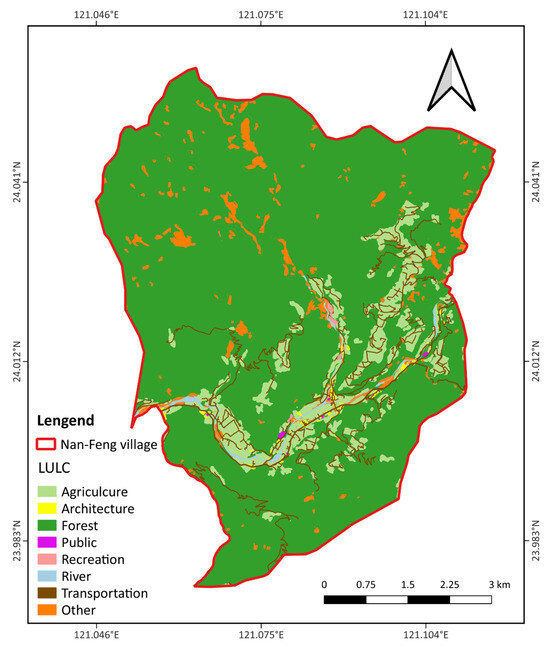
Figure 2.
LULC classification map of Nanfeng Village, delineated by the red boundary. The map shows categories including agriculture, architecture, forest, public facilities, recreation, river, transportation, and other land uses.
2.3. Methods
This study employed a multi-step geospatial analysis framework to investigate vegetation dynamics and their relationship to landslide susceptibility. The methodology integrates remote-sensing techniques, statistical trend analysis, and spatiotemporal hot spot detection to assess ecological stability across the study area. Each component of the workflow was designed to extract meaningful insights from high-resolution satellite imagery, enabling robust monitoring of vegetation changes over time.
2.3.1. NDVI Calculation and Preprocessing
The NDVI [44] was calculated using the standard formula:
In this equation, NIR refers to the near-infrared band and RED refers to the red band of the satellite imagery. NDVI preprocessing and computation followed different workflows depending on the satellite sensor used. SPOT imagery was employed for long-term analysis (2013–2023), while Pléiades imagery was used for short-term trend detection (2019–2023).
The SPOT images, provided in preprocessed format with TOAR corrections already applied, required no additional radiometric adjustments. NDVI values were calculated directly from the NIR and red spectral bands using the raster calculator in R (version 4.3.2). To minimize cloud contamination, the MVC method was applied to multiple images within the same year, selecting the highest NDVI value for each pixel location to generate one annual NDVI composite for trend analysis.
In contrast, Pléiades imagery was provided as raw digital numbers (DN) and required radiometric preprocessing. First, DN values were converted to spectral radiance using gain and offset values obtained from the image metadata. Then, radiance was transformed into TOAR by accounting for solar irradiance, solar zenith angle at the time of image acquisition, and Earth–Sun distance. Once TOAR was obtained, NDVI was calculated using the calibrated NIR and red bands. This process ensured inter-annual consistency and sensor comparability across all Pléiades datasets.
A total of five annual NDVI layers (2019–2023) were produced from Pléiades imagery. These were used for short-term vegetation trend analysis at higher spatial resolution. The combined SPOT and Pléiades NDVI series provided a multi-scale view of vegetation dynamics across the study area.
2.3.2. Trend Analysis Using the MK Trend Test
To detect monotonic trends in vegetation cover over time, the non-parametric MK trend test was applied to each pixel’s NDVI time series using the rkt package in R. The MK trend test is widely used for trend analysis in environmental and hydrological time series due to its robustness against non-normal data distributions and its ability to handle missing values or outliers [45,46,47].
For long-term analysis, eleven NDVI layers derived from SPOT imagery (2013–2023) were used. These datasets enabled the detection of gradual vegetation changes across the landscape, reflecting long-term processes such as forest regrowth, land degradation, or post-disturbance recovery. Due to the coarser resolution of SPOT data, this analysis was best suited for identifying regional-scale trends.
For short-term vegetation dynamics, five annual NDVI layers from Pléiades imagery (2019–2023) were utilized. These high-resolution datasets captured more localized or recent vegetation changes, potentially linked to typhoon events or slope disturbances.
Each pixel’s NDVI time series was tested against the null hypothesis of no monotonic trend. MK trend test results were categorized based on statistical significance thresholds: , , and . Resulting trend maps indicated both the direction (positive or negative) and the statistical reliability of detected changes. Together, the MK analyses based on SPOT and Pléiades imagery offered a multi-scale perspective on vegetation stability, degradation, and recovery throughout Nanfeng Village.
2.3.3. EHSA with Space-Time Cube
To investigate statistically significant spatiotemporal clusters of NDVI change, an EHSA was conducted using the space-time cube framework in ArcGIS Pro 10.4.1. This technique integrates spatial autocorrelation and temporal trend detection to identify areas experiencing consistent or emerging vegetation change over time.
The analysis followed a four-step procedure:
- 1.
- Annual NDVI rasters (2013–2023) from SPOT imagery were resampled and stacked to ensure spatial and temporal consistency. NDVI values, along with their corresponding spatial coordinates and timestamps, were exported.
- 2.
- A space-time cube was constructed using the “Create Space Time Cube by Aggregating Points” tool in ArcGIS Pro. This tool aggregated NDVI values into spatial bins (200 m × 200 m grid cells) and annual temporal slices. The final cube was stored in NetCDF format for multidimensional analysis.
- 3.
- The “Emerging Hot Spot Analysis” tool was then applied to the cube. This tool performed two core statistical operations:
- The Getis-Ord Gi* statistic identified statistically significant clusters of high or low NDVI values (i.e., hot spots and cold spots) for each year.
- The MK trend test detected temporal trends in these clusters, classifying whether hot spot activity was intensifying, diminishing, or remaining stable.
- 4.
- Each spatial location was classified into one of 17 spatiotemporal hot spot categories (Table 2), such as new hot spot, intensifying hot spot, persistent cold spot, oscillating cold spot, and other temporal patterns defined by the Emerging Hot Spot Analysis tool.
Table 2. Definitions of the 17 spatiotemporal hot spot and cold spot categories used in this study, based on [48] but rewritten for clarity. These categories characterize locations according to the statistical significance, temporal persistence, and directional trends of clustering intensity for high or low values across the study period.
This integrated method allows the detection of both chronic (long-standing) and emerging (recent or rapidly changing) vegetation patterns. By combining spatial autocorrelation (Gi*) with temporal trend detection (MK trend test), EHSA provides a structured approach for analyzing landscape change over time, particularly in regions susceptible to natural hazards [48,49].
3. Results
This section presents the key analytical findings on vegetation dynamics and slope hazard risk in Nanfeng Village. Results are organized into two major components: (1) NDVI trend detection using the MK trend test, and (2) spatiotemporal classification of vegetation change using EHSA. The combination of trend detection and hot spot categorization offers a structural understanding of how vegetation patterns have evolved over time and where potential instability may persist.
3.1. Vegetation Trend Analysis via MK Trend Test
To assess long-term vegetation dynamics in Nanfeng Village, the MK trend test was applied to NDVI time series derived from SPOT imagery (2013–2023) and Pléiades imagery (2019–2023). As a non-parametric method, the MK trend test is particularly effective for identifying monotonic trends in environmental time series, regardless of data distribution or the presence of outliers.
The SPOT-based trend map (Figure 3a) shows mostly positive NDVI trends across the study area, with many low-lying zones near stream corridors, residential settlements, or areas adjacent to cultivated lands exhibiting statistically significant vegetation increases over the 11-year period. These patterns likely reflect a combination of natural regrowth, land management efforts, and reforestation activities. However, the presence of recurring disturbances in some river-adjacent zones suggests that not all lowland areas are recovering uniformly. Conversely, localized negative NDVI trends were primarily observed on the steep upper slopes of the Nanshan Creek watershed, which may be experiencing persistent erosion, geomorphic instability, or limited vegetation regeneration due to ongoing slope disturbance.
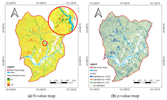
Figure 3.
MK trend analysis of SPOT imagery (2013–2023) for Nanfeng Village, Jenai Township, showing (a) an S-value map indicating the direction and magnitude of trends, and (b) a p-value map highlighting areas of statistical significance.
Trend significance was assessed using p-values (Figure 3b). Many of the positive NDVI trends in valley-bottom and mid-slope areas were statistically significant at the 95% confidence level (), reinforcing the interpretation of long-term vegetative recovery. In contrast, negative NDVI trends in rugged terrain were generally not significant, likely due to high interannual variability, intermittent disturbance, or vegetation heterogeneity. This emphasizes the importance of evaluating both trend magnitude and statistical confidence in tandem when interpreting vegetation dynamics.
The Pléiades-based analysis (2019–2023) offers higher spatial resolution and a shorter temporal window for evaluating recent vegetation trends. The NDVI trend map (Figure 4a) exhibits similar spatial patterns, with most positive trends clustered along rivers and mid-elevation slopes, and negative trends limited to isolated, erosion-prone regions. The corresponding p-value map (Figure 4b) confirms the persistence of statistically significant vegetation gains in previously identified zones.
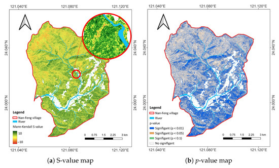
Figure 4.
MK trend analysis of Pléiades imagery (2019–2023) for Nanfeng Village, Jenai Township, showing (a) an S-value map representing the direction and magnitude of trends, and (b) a p-value map identifying areas of statistical significance.
Overall, the MK trend analysis reveals a spatially heterogeneous vegetation response across Nanfeng Village. Zones of consistent NDVI increase are concentrated near water bodies and stable terrain, whereas stagnating or declining NDVI trends are predominantly observed in steep, disturbed areas. These findings suggest a strong topographic control on vegetation dynamics and reinforce the utility of NDVI trend analysis for identifying slope conditions and potential risk zones.
3.2. NDVI Emerging Hot Spot Classification
To better understand the spatiotemporal evolution of vegetation cover, EHSA was performed using SPOT-based NDVI composites from 2013 to 2023. The space-time cube framework allowed for detection of statistically significant clusters of NDVI change and their classification into hot spot and cold spot categories over time.
The EHSA results highlight a complex spatial mosaic of NDVI behavior. Out of the 17 spatiotemporal hot and cold spot types defined in Table 2, only 14 were observed in the study area, with no occurrences of new hot spots, diminishing hot spots, or historical cold spots. Hot spots accounted for approximately 59.3% of the study area, cold spots for about 32.2%, and areas with no statistically significant pattern for 8.5%. Among the 14 EHSA categories, oscillating patterns were the most prevalent (about 50%), with oscillating cold spots comprising 20.8%—primarily near rivers and settlements—and oscillating hot spots comprising 28.9%, typically surrounding oscillating cold spots and extending into hillslopes. Intensifying patterns represented roughly 30%, with intensifying cold spots (0.7%) concentrated on mountain slopes enclosed by oscillating cold spots, and intensifying hot spots (28.8%) largely located in high-elevation, undeveloped areas without river influence. Other categories included persistent (4.4%), diminishing (4.0%), sporadic (3.2%), consecutive (0.19%), new (0.17%), and historical (0.04%) hot/cold spots. Spatially, as illustrated in Figure 5, the upper part of Nanfeng Village is dominated by oscillating hot spots interspersed with smaller clusters of oscillating cold spots, the middle part shows a more balanced distribution of hot and cold spot patterns along river corridors and hillslopes, and the lower part is characterized by a patchwork of oscillating and intensifying hot spots surrounding isolated cold spot zones.
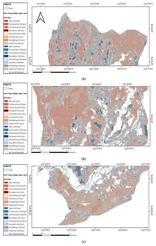
Figure 5.
Spatial distribution of NDVI hot and cold spot patterns in Nanfeng Village, Jenai Township, categorized into (a) upper, (b) middle, and (c) lower regions. The maps illustrate different temporal trend types, including new, consecutive, intensifying, persistent, diminishing, sporadic, oscillating, and historical hot or cold spots, as well as areas with no detected trend.
Cold spots—areas with persistently low or decreasing NDVI—were mainly concentrated along steep, erosion-prone slopes and known debris-flow paths. While some cold spots occurred near rivers and valley-bottom settlements, especially in historically unstable zones, these areas also contained pockets of NDVI increase, indicating vegetation recovery. Oscillating and diminishing cold spots were particularly concentrated on unstable or flood-prone slopes, where recurrent vegetation loss is often driven by typhoons, erosion, or shallow landslides. In contrast, hot spots—zones of persistent or intensifying vegetation health—were identified in valley-bottom, mid-slope, and forested areas at mid to high elevations, often far from anthropogenic disturbance. Intensifying hot spots were found mainly in undisturbed forests and upper elevations, exhibiting a statistically significant increasing trend in NDVI clustering over time, whereas consecutive hot spots, representing recent and sustained increases in vegetation health, were located primarily in mid-slope reforestation areas.
The comprehensive hot and cold spot classification map (Figure 6) integrates the results from the upper, middle, and lower sections of Nanfeng Village into a single, continuous depiction of NDVI temporal patterns from 2013 to 2023. By combining intensifying, new, persistent, oscillating, and diminishing hot and cold spots into a unified framework, the map provides a clear overview of spatial relationships across the entire study area. This integrated perspective highlights the transition from the forest-dominated upper section to the more mixed vegetation patterns of the middle and lower sections, reflecting variations in both vegetation gains and losses. Insets focus on key landmarks—Mengku Waterfall, Sung-Yuan Lane, the Catholic Church, and a gas station—capturing localized patterns of vegetation change linked to both natural processes and human activities.
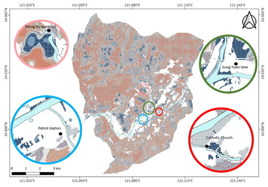
Figure 6.
Comprehensive classification of NDVI emerging hot and cold spots in Nanfeng Village, Jenai Township, derived from 2013–2023 SPOT imagery. The map highlights intensifying, new, persistent, oscillating, and diminishing hot and cold spot zones, with insets showing detailed patterns around key landmarks, including Mengku Waterfall, Sung-Yuan Lane, the Catholic Church, and a gas station.
To improve the spatial interpretation of NDVI hot and cold spot dynamics, three-dimensional visualizations were produced for the Mengku Waterfall slope region—an area of complex terrain and documented past hazard events (Figure 7). The mid-slope area exhibits intensifying cold spots surrounded by persistent cold spots, indicating a statistically significant and continuing decline in vegetation. Along the outer slope, diminishing and oscillating cold spots are present; the former suggest a slowing rate of vegetation loss, whereas the latter alternate between cold and hot spot phases, reflecting intermittent vegetation recovery. Transitional zones near the slope boundary display a mix of oscillating hot spots and areas without statistically significant patterns, highlighting localized variability in vegetation dynamics.
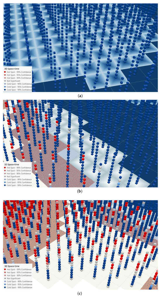
Figure 7.
Three-dimensional visualization of NDVI hot and cold spots in the Mengku Waterfall slope area, Nanfeng Village, Jenai Township. Panels show: (a) a concentrated cold spot cluster in the mid-slope area near Mengku Waterfall, (b) cold spot distribution on the outer slope of the same region, and (c) alternating NDVI hot and cold spot patterns around the slope boundary.
This area provides a clear example in which identified NDVI cold and hot spots correspond with documented disaster impacts in a waterfall environment. Figure 8a compares NDVI hot and cold spot patterns with Google Earth imagery of the Mengku Waterfall slope, revealing strong spatial correspondence between these spots and previously recorded landslide scars. This relationship is further supported by the post-event UAV photograph in Figure 8b, taken after Typhoon Khanun in 2023, which shows evident slope instability, exposed soil surfaces, and substantial vegetation loss in the vicinity of the waterfall.
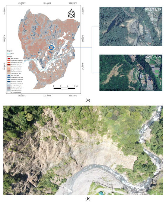
Figure 8.
Comparison of remote-sensing analysis and field observations at the Mengku Waterfall slope. (a) NDVI hot- and cold-spot patterns derived from SPOT imagery (2013–2023) for Nanfeng Village, shown alongside a Google Earth Pro image of the slope near Mengku Waterfall to highlight the visual correspondence with identified areas. (b) UAV photograph of the slope adjacent to Mengku Waterfall, taken in 2023 following Typhoon Khanun, showing terrain disturbance and vegetation loss.
To further illustrate the severity of the Typhoon Khanun disaster, Figure 9a,b present post-event photographs taken in 2023, after Typhoon Khanun and following initial debris clearance. These sites—the Catholic Church and the St. Benedict Gas Station—were previously shown in Figure 6. In Figure 9a, the Catholic Church is located along the DF011 potential debris-flow stream, where severe debris accumulation occurred after the typhoon. Figure 9b shows the St. Benedict Gas Station along the DF013 potential debris-flow stream, which has been repeatedly buried by debris flows triggered by past typhoons. Typhoon Khanun caused another burial of the gas station. Even after clean-up, both locations exhibit evident sediment deposition and structural vulnerability, reinforcing the spatial correspondence between NDVI cold spots and areas of both high hazard susceptibility and actual disaster occurrence.
Overall, the EHSA adds temporal depth to the vegetation trend assessment and provides a robust classification of spatial stability and vulnerability. The consistency between cold-spot zones and known landslide paths underscores the value of EHSA as a tool for slope-hazard monitoring. When integrated with MK trend results and NDVI differencing, these findings present a comprehensive spatial framework for guiding future ecological restoration and risk mitigation strategies in Nanfeng Village.

Figure 9.
Field photographs documenting disaster impacts in the southern region of Nanfeng Village. (a) Post-disaster view of the downstream section of the DF011 potential debris-flow stream near the Catholic Church. (b) Post-disaster conditions at the St. Benedict Gas Station along the DF013 potential debris-flow stream, illustrating slope failure, debris accumulation, and associated infrastructure risk. Both photographs were taken after initial debris clearance.
4. Discussion
This study illustrates the potential of integrating satellite-derived NDVI time series with spatiotemporal statistical techniques—specifically, the MK trend test and EHSA—to detect vegetation dynamics and assess slope-hazard susceptibility in mountainous environments such as Nanfeng Village. Together, these methods reveal complex patterns of ecological change that align closely with known terrain characteristics and geomorphic risks.
The MK analysis revealed statistically significant increasing NDVI trends in many valley-bottom regions and near human settlements; however, these areas also exhibited considerable variability, with some locations showing persistent declines. Such differences likely reflect a combination of factors, including the frequency and magnitude of debris-flow events, the extent of natural vegetation recovery, and the type and intensity of human activities. Areas with positive trends often benefited from natural regrowth, active reforestation, or land-use stabilization through community-level management, whereas negative trends were more commonly linked to repeated disturbance, erosion, or slope instability. In contrast, steep upper slopes consistently displayed declining NDVI values, reflecting their susceptibility to shallow landslides, erosional processes, and debris-flow activity—patterns that align with previous research indicating that vegetation loss often correlates with high-risk geomorphic processes in mountainous regions [50]. These results are consistent with previous remote-sensing and GIS-based studies that have successfully delineated landslide-susceptibility zones and remotely identified potentially hazardous areas [51,52]. Such studies have demonstrated that susceptibility maps can closely match historical landslide records, underscoring their value in supporting early warning systems and guiding targeted hazard-mitigation efforts.
The addition of EHSA enriched the trend analysis by introducing a spatiotemporal classification framework. By categorizing areas into intensifying, persistent, oscillating, or diminishing hot and cold spots, EHSA enabled a deeper understanding of how vegetation behavior evolves over time. For instance, persistent and oscillating cold spots were primarily located along the Mei and Nanshan Creek corridors, indicating that, despite some long-term NDVI recovery trends, vegetation in these zones remains spatially unstable—likely due to recurring debris-flow or slope-failure activity. These zones also corresponded to low NDVI values and minimal vegetation recovery, reinforcing their role as long-term ecological stress areas. The 3D visualizations provided further insight by displaying the time dimension along the vertical axis, allowing the visualization of vegetation change through time and showing how slope position and topographic exposure influence NDVI variability.
The observed consistency between MK trend outputs and EHSA classifications is expected, as the EHSA framework explicitly incorporates the MK trend test in its temporal trend evaluation. Rather than indicating redundancy, this alignment reinforces the reliability of EHSA’s integrated spatiotemporal trend detection, particularly in identifying emerging vegetation anomalies. While the MK trend test quantifies monotonic trends, EHSA extends the analysis by detecting clustering patterns and the temporal evolution of hot and cold spots. Together, they provide a synergistic framework for interpreting vegetation dynamics and identifying potential hazard zones in data-limited, mountainous regions such as central Taiwan.
Despite its advantages, this study is subject to several limitations. First, NDVI can saturate in areas of dense vegetation, potentially masking subtle shifts in canopy structure or vegetation health. Second, the use of annual time slices in the space-time cube may obscure short-term vegetation fluctuations following events such as typhoons or droughts. Third, the absence of field-based validation limits the ability to interpret the biological or mechanical processes underlying observed NDVI changes. Although NDVI saturation may affect densely vegetated areas, no alternative indices (e.g., Soil-Adjusted Vegetation Index (SAVI) or Modified Soil-Adjusted Vegetation Index (MSAVI)) were applied in this study. This limitation, along with the lack of field verification, may reduce the precision of NDVI-based assessments. Future research could benefit from incorporating additional indices, such as the Enhanced Vegetation Index (EVI) and the Normalized Difference Water Index (NDWI), integrating Light Detection and Ranging (LiDAR)-derived terrain metrics, and establishing field plots for systematic ground-truth validation. Machine learning classification approaches could also enhance the automation and precision of hazard-zone identification.
5. Conclusions
This study demonstrates the value of combining NDVI time series with MK trend analysis and EHSA to evaluate vegetation change and infer slope hazard risk in a complex mountainous landscape. The MK trend test effectively identified areas of consistent vegetation increase or decline, while EHSA classified these changes into meaningful temporal and spatial categories. The combined approach captures both long-term ecological recovery and episodic vegetation loss associated with unstable terrain.
The spatial and temporal classifications revealed clear patterns in vegetation change across the study area. Hot spots accounted for approximately 59.3% of the study area, cold spots for approximately 32.2%, and areas with no statistically significant pattern for approximately 8.5%. Among the 14 EHSA categories, oscillating patterns were the most prevalent (about 50%), with oscillating cold spots comprising 20.8%—mainly near rivers and settlements—and oscillating hot spots comprising 28.9%, often surrounding oscillating cold spots and extending into hillslopes. Intensifying patterns represented roughly 30%, dominated by intensifying hot spots (28.8%) in high-elevation, undeveloped terrain.
The proposed framework is scalable and adaptable to other mountainous or typhoon-prone regions with similar data availability and environmental constraints. By leveraging satellite-derived NDVI trends and spatiotemporal hot spot classifications, stakeholders can enhance disaster preparedness, guide field inspections, and support land-use planning efforts aimed at improving slope stability.
Building on these findings, the integration of long-term trend detection with spatiotemporal hot spot analysis offers a practical approach for examining vegetation dynamics and identifying potentially vulnerable slopes in typhoon-prone environments. To extend its practical relevance, we propose the following key methodological recommendations: (1) use long-term NDVI trends to identify zones of vegetation degradation and recovery as indirect indicators of slope stability; (2) apply EHSA to reveal spatiotemporal patterns of ecological stress or regeneration, particularly in areas subject to recurring disturbances; and (3) integrate the results with hazard datasets such as landslide inventories or post-disaster imagery to validate potential risk zones. Although this study used commercially licensed satellite imagery and software, the workflow can be replicated with freely available datasets (e.g., Sentinel-2, Landsat) and open-source tools (e.g., Google Earth Engine, R, QGIS). This adaptability enhances its utility for disaster preparedness, ecological monitoring, and early warning systems. Continued refinement and integration with local datasets could further improve its applicability for landscape management in Taiwan and beyond.
Author Contributions
Conceptualization, W.C.; data curation, Y.-J.J. and W.C.; funding acquisition, W.C.; investigation, Y.-J.J., K.A.N. and W.C.; methodology, W.C.; project administration, W.C.; resources, W.C.; software, Y.-J.J. and K.A.N.; supervision, W.C.; validation, K.A.N.; visualization, Y.-J.J. and K.A.N.; writing—original draft, W.C. and K.A.N.; writing—review and editing, W.C. and K.A.N. All authors have read and agreed to the published version of the manuscript.
Funding
This study was partially supported by the National Science and Technology Council (Taiwan) under Research Project Grant Numbers NSTC 113-2121-M-008-004 and NSTC 113-2625-M-027-007.
Institutional Review Board Statement
Not applicable.
Informed Consent Statement
Not applicable.
Data Availability Statement
The data used in this study are not publicly available due to restrictions imposed by the data owner or source. Therefore, the data cannot be disseminated or shared as part of this publication. Interested researchers can request access to the data directly from the data owner or source, subject to their terms and conditions. The authors confirm that they do not have the right to distribute the data used in this study.
Acknowledgments
This study is based on the Master’s thesis work of Yi-Jia Jiang, conducted at National Taipei University of Technology. The authors acknowledge the use of ChatGPT 4o, an AI language model developed by OpenAI, to assist with improving the clarity and quality of the manuscript’s language. All content generated or revised with the help of this tool has been carefully reviewed by the authors, who bear full responsibility for the final version of the manuscript. The authors gratefully acknowledge the Center for Space and Remote Sensing Research (CSRSR) at National Central University (NCU) for providing the satellite imagery used in this study. SPOT-6/7 imagery: © Airbus DS 2013–2023; Pléiades imagery: © CNES 2019–2023, Distribution Airbus DS. The imagery data were sublicensed by Airbus DS from CSRSR, NCU. The authors would also like to thank the National Science and Technology Council (NSTC) and CSRSR/NCU for supplying the satellite imagery data. The authors also sincerely thank Ya-Lun Lin for providing the photographs used in this study.
Conflicts of Interest
The authors declare no conflicts of interest.
References
- Geertsema, M.; Highland, L.; Vaugeouis, L. Environmental impact of landslides. In Landslides—Disaster Risk Reduction; Springer: Berlin/Heidelberg, Germany, 2009; pp. 589–607. [Google Scholar] [CrossRef]
- Stokes, A.; Douglas, G.B.; Fourcaud, T.; Giadrossich, F.; Gillies, C.; Hubble, T.; Kim, J.H.; Loades, K.W.; Mao, Z.; McIvor, I.R.; et al. Ecological mitigation of hillslope instability: Ten key issues facing researchers and practitioners. Plant Soil 2014, 377, 1–23. [Google Scholar] [CrossRef]
- Gray, D.H.; Sotir, R.B. Biotechnical and Soil Bioengineering Slope Stabilization: A Practical Guide for Erosion Control; John Wiley & Sons: New York, NY, USA, 1996. [Google Scholar]
- Masi, E.B.; Segoni, S.; Tofani, V. Root reinforcement in slope stability models: A review. Geosciences 2021, 11, 212. [Google Scholar] [CrossRef]
- Pettorelli, N. The Normalized Difference Vegetation Index; Oxford University Press: New York, NY, USA, 2013. [Google Scholar] [CrossRef]
- Tian, F.; Fensholt, R.; Verbesselt, J.; Grogan, K.; Horion, S.; Wang, Y. Evaluating temporal consistency of long-term global NDVI datasets for trend analysis. Remote Sens. Environ. 2015, 163, 326–340. [Google Scholar] [CrossRef]
- Xu, B.; Qi, B.; Ji, K.; Liu, Z.; Deng, L.; Jiang, L. Emerging hot spot analysis and the spatial–temporal trends of NDVI in the Jing River Basin of China. Environ. Earth Sci. 2022, 81, 55. [Google Scholar] [CrossRef]
- Hölbling, D.; Friedl, B.; Eisank, C. An object-based approach for semi-automated landslide change detection and attribution of changes to landslide classes in northern Taiwan. Earth Sci. Inform. 2015, 8, 327–335. [Google Scholar] [CrossRef]
- Getis, A.; Ord, J.K. The analysis of spatial association by use of distance statistics. Geogr. Anal. 1992, 24, 189–206. [Google Scholar] [CrossRef]
- Zhong, Z.; Fang, X.; Li, J.; Ma, Q.; Zhou, R.; Hu, Y.; Du, S. Linear and non-linear dynamics of ecosystem services supply, demand, and mismatches across a rapidly urbanizing region. Ecol. Indic. 2024, 158, 111614. [Google Scholar] [CrossRef]
- Cao, Z.; Wu, M.; Wang, D.; Wan, B.; Jiang, H.; Tan, X.; Zhang, Q. Space-time cube uncovers spatiotemporal patterns of basin ecological quality and their relationship with water eutrophication. Sci. Total Environ. 2024, 916, 170195. [Google Scholar] [CrossRef]
- Wang, Y.; He, Y.; Li, J.; Jiang, Y. Evolution simulation and risk analysis of land use functions and structures in ecologically fragile watersheds. Remote Sens. 2022, 14, 5521. [Google Scholar] [CrossRef]
- Liu, Y.; Hou, P.; Wang, P.; Zhu, J.; Zhai, J.; Chen, Y.; Wang, J.; Xie, L. Quantitative analysis about the spatial heterogeneity of water conservation services function using a space–time cube constructed based on ecosystem and soil types. Diversity 2024, 16, 638. [Google Scholar] [CrossRef]
- Yan, D.; Yu, H.; Xiang, Q.; Xu, X. Spatiotemporal patterns of land surface temperature and their response to land cover change: A case study in Sichuan Basin. Egypt. J. Remote Sens. Space Sci. 2023, 26, 1080–1089. [Google Scholar] [CrossRef]
- Ahmadi, H.; Mousavi, B.S.; Argany, M.; Soleimani, M.; Ghanbari, A. Spatiotemporal forecasting of water change trends in Urmia Lake through to 2030, using STC-based models. Hydrol. Sci. J. 2024, 69, 1631–1651. [Google Scholar] [CrossRef]
- Wei, J.; Zhong, Y.; Chen, A.; Tang, H.; Li, D. Space-time cube reveals escalating light pollution in China’s national parks: Impact of boundary geometry and human activities (1992–2021). Environ. Pollut. 2025, 126462. [Google Scholar] [CrossRef] [PubMed]
- Wu, C. Certainty factor analyses and spatiotemporal characteristics of landslide evolution: Case studies in the Chishan river watershed in Taiwan. ISPRS Int. J.-Geo-Inf. 2022, 11, 382. [Google Scholar] [CrossRef]
- Wu, C.-H. Evaluating the landslide stability and vegetation recovery: Case studies in the Tsengwen reservoir watershed in Taiwan. Water 2021, 13, 3479. [Google Scholar] [CrossRef]
- Younas, M.; Khan, S.D.; Qasim, M.; Hamed, Y. Assessing impacts of land subsidence in Victoria County, Texas, using geospatial analysis. Land 2022, 11, 2211. [Google Scholar] [CrossRef]
- Mitasova, H.; Hardin, E.; Starek, M.J.; Harmon, R.S.; Overton, M.F. Landscape Dynamics from LiDAR Data Time Series; International Society for Geomorphometry, 2011; pp. 3–6. Available online: https://geospatial.ncsu.edu/geoforall/pubpdf/Mitasova2011geomorphometry.pdf (accessed on 1 January 2024).
- Melville, T.; Sutherland, M.; Wuddivira, M.N. Assessing trends and predicting the cover management factor in a tropical island state using enhanced vegetation index. SN Appl. Sci. 2020, 2, 1686. [Google Scholar] [CrossRef]
- Memisoglu Baykal, T. GIS-based spatiotemporal analysis of forest fires in Turkey from 2010 to 2020. Trans. GIS 2023, 27, 1289–1317. [Google Scholar] [CrossRef]
- Unnikrishnan, A.; Reddy, C.S. Characterizing distribution of forest fires in Myanmar using earth observations and spatial statistics tool. J. Indian Soc. Remote Sens. 2020, 48, 227–234. [Google Scholar] [CrossRef]
- Wei, J.; Wang, Z.; Han, L.; Shang, J.; Zhao, B. Analysis of spatio-temporal evolution characteristics of drought and its driving factors in Yangtze River Basin based on SPEI. Atmosphere 2022, 13, 1986. [Google Scholar] [CrossRef]
- Pyarali, K.; Peng, J.; Disse, M.; Tuo, Y. Development and application of high resolution SPEI drought dataset for Central Asia. Sci. Data 2022, 9, 172. [Google Scholar] [CrossRef]
- Zhang, H.; Jia, H.; Liu, W.; Wang, J.; Xu, D.; Li, S.; Liu, X. Spatiotemporal information mining for emergency response of urban flood based on social media and remote sensing data. Remote Sens. 2023, 15, 4301. [Google Scholar] [CrossRef]
- He, X.; Zhang, R.; Yuan, X.; Cao, Y.; Zhou, C. The role of planning policy in the evolution of the spatial structure of the Guangzhou metropolitan area in China. Cities 2023, 137, 104284. [Google Scholar] [CrossRef]
- Foșalău, C.-M.; Roșu, L.; Iațu, C.; Dinter, O.-V.; Cristodulo, P.-M. Mapping urban changes through the spatio-temporal analysis of vegetation and built-up areas in Iași, Romania. Sustainability 2025, 17, 11. [Google Scholar] [CrossRef]
- Ghanghermeh, A.; Roshan, G.; Asadi, K.; Attia, S. Spatiotemporal Analysis of Urban Heat Islands and Vegetation Cover Using Emerging Hotspot Analysis in a Humid Subtropical Climate. Atmosphere 2024, 15, 161. [Google Scholar] [CrossRef]
- Ali, A.A.B.; Mitra, C.; Rahaman, S.N. Mapping the heat with spatial trends and emerging temperature hotspots in the Contiguous US (CONUS) counties from 2000 to 2022. Spat. Inf. Res. 2025, 33, 35. [Google Scholar] [CrossRef]
- Xu, S.; Shirowzhan, S.; Sepasgozar, S. Spatiotemporal analysis and GIS-based dashboard development for urban household waste. Smart Sustain. Built Environ. 2025. [Google Scholar] [CrossRef]
- Jiang, Y.; Zhao, S.; Li, H.; Lei, J.; He, L.; Zhu, G.; Bu, J. Spatial-temporal analysis of street patrol cases in Zhengzhou, China, using Getis-Ord Gi* and space-time cube. In Proceedings of the 2023 3rd International Conference on Public Management and Intelligent Society (PMIS 2023), Wuhan, China, 10–12 March 2023; pp. 648–654. [Google Scholar] [CrossRef]
- Guo, M.; Gou, C.; Tan, S.; Feng, C.; Zhao, F. Spatiotemporal characteristics and factors influencing the cycling behavior of shared electric bike use in urban plateau regions. Sustainability 2024, 16, 6570. [Google Scholar] [CrossRef]
- Abdulrazaq, M.A.; Fan, W. A priority based multi-level heterogeneity modelling framework for vulnerable road users. Transp. A Transp. Sci. 2025, 1–34, in press. [Google Scholar] [CrossRef]
- Bilim, A. Identifying unsafe locations for pedestrians in Konya with spatio-temporal analyses. Cities 2025, 156, 105523. [Google Scholar] [CrossRef]
- Sae-Ngow, P.; Kulpanich, N.; Worachairungreung, M.; Sittarachu, N.; Thanakunwutthirot, K.; Hemwan, P. Identification of road crash zones, spatial patterns, and emerging hot spots of road traffic injury severity in Phuket, Thailand. Geoj. Tour. Geosites 2025, 60, 1067–1077. [Google Scholar] [CrossRef]
- Kim, M.; Lee, S. Identification of Emerging Roadkill Hotspots on Korean Expressways Using Space–Time Cubes. Int. J. Environ. Res. Public Health 2023, 20, 4896. [Google Scholar] [CrossRef]
- Kabanda, T.H. Case study: Analysing the progression of artificial lighting in Gauteng Province over a decade using spatio-temporal analysis. Int. J. Cartogr. 2024, 1–17. [Google Scholar] [CrossRef]
- Osman, A.; Owusu, A.B.; Adu-Boahen, K.; Atamey, E. Space-time cube approach in analysing conflicts in Africa. Soc. Sci. Humanit. Open 2023, 8, 100557. [Google Scholar] [CrossRef]
- Xu, R.; Yang, X.; Tian, S. Use of space-time cube model and spatiotemporal hot spot analyses in fisheries—A case study of tuna purse seine. Fishes 2023, 8, 525. [Google Scholar] [CrossRef]
- Fuentes, M.V.B.; Heenkenda, M.K.; Sahota, T.S.; Serrano, L.S. Analyzing winter wheat (Triticum aestivum) growth pattern using high spatial resolution images: A case study at Lakehead University Agriculture Research Station, Thunder Bay, Canada. Crops 2024, 4, 115–133. [Google Scholar] [CrossRef]
- Kong, J.; An, Y.; Shi, X.; Sun, Z.; Wu, L.; Cui, W. Meteorological-Data-Driven Rubber Tree Powdery Mildew Model and Its Application on Spatiotemporal Patterns: A Case Study of Hainan Island. Sustainability 2023, 15, 12119. [Google Scholar] [CrossRef]
- Climate-Data. Climate: Ren’ai Township. Available online: https://en.climate-data.org/asia/taiwan/ren-ai-township/ren-ai-township-12975/ (accessed on 8 August 2025).
- Rouse, J.W.; Haas, R.H.; Schell, J.A.; Deering, D.W. Monitoring Vegetation Systems in the Great Plains with ERTS; NASA Technical Report, NASA-TM-X-62029; Texas A&M University: College Station, TX, USA, 1974. [Google Scholar]
- Mann, H.B. Nonparametric tests against trend. Econometrica 1945, 13, 245–259. [Google Scholar] [CrossRef]
- Kendall, M.G. Rank Correlation Methods, 4th ed.; Charles Griffin: London, UK, 1975. [Google Scholar]
- Hirsch, R.M.; Slack, J.R.; Smith, R.A. Techniques of trend analysis for monthly water quality data. Water Resour. Res. 1982, 18, 107–121. [Google Scholar] [CrossRef]
- Esri. How Emerging Hot Spot Analysis Works. Available online: https://pro.arcgis.com/en/pro-app/latest/tool-reference/space-time-pattern-mining/learnmoreemerging.htm (accessed on 20 June 2025).
- Kang, J.-S.; Lee, S.-H.; Kim, M.-S. Detecting Spatio-Temporal Vegetation Changes Using Emerging Hot Spot Analysis and Mann–Kendall Trend Test: A Case Study of South Korea. Remote Sens. 2020, 12, 475. [Google Scholar] [CrossRef]
- Chakraborty, A. Mountains as vulnerable places: A global synthesis of changing mountain systems in the Anthropocene. GeoJournal 2021, 86, 585–604. [Google Scholar] [CrossRef]
- Shah, N.A.; Shafique, M.; Owen, L.A.; Al-Mulla, Y.; Ullah, Y. Morphometric analysis of debris flow hazard and risk assessment in the mountain terrains of northern Pakistan using remote sensing and field data. Earth Sci. Inform. 2025, 18, 295. [Google Scholar] [CrossRef]
- Hsu, C.-H.; Tsao, T.-C.; Huang, C.-M.; Lee, C.-F.; Lee, Y.-T. Using remote sensing techniques to identify the landslide hazard prone sections along the south link railway in Taiwan. Procedia Eng. 2016, 143, 708–716. [Google Scholar] [CrossRef]
Disclaimer/Publisher’s Note: The statements, opinions and data contained in all publications are solely those of the individual author(s) and contributor(s) and not of MDPI and/or the editor(s). MDPI and/or the editor(s) disclaim responsibility for any injury to people or property resulting from any ideas, methods, instructions or products referred to in the content. |
© 2025 by the authors. Licensee MDPI, Basel, Switzerland. This article is an open access article distributed under the terms and conditions of the Creative Commons Attribution (CC BY) license (https://creativecommons.org/licenses/by/4.0/).