Article

Coastal Geoheritage and Sustainability: A Study in the Low Coast of Costa Branca, Rio Grande do Norte, Brazil

by
Fernando Eduardo Borges da Silva
1,
Matheus Dantas das Chagas
1,
Marco Túlio Mendonça Diniz
2 and
Paulo Pereira
3,*
1
Centre for Humanities, Literature and Arts, Federal University of Rio Grande do Norte, Natal 59078-970, Brazil
2
Department of Geography, Seridó Higher Education Centre, Federal University of Rio Grande do Norte, Caicó 59300-000, Brazil
3
Institute of Earth Sciences, University of Minho, 4710-057 Braga, Portugal
*
Author to whom correspondence should be addressed.
Sustainability 2025, 17(15), 6709; https://doi.org/10.3390/su17156709
Submission received: 15 May 2025 / Revised: 15 July 2025 / Accepted: 17 July 2025 / Published: 23 July 2025

Abstract

This study assesses the risk of geoheritage degradation along a low-lying coastal stretch Okin the municipalities of Macau, Guamaré, and Galinhos, located in the central portion of Rio Grande do Norte’s northern coastline, Brazil. Twelve geosites, inventoried based on their scientific value, susceptibility to degradation, and representation of diverse coastal processes and landforms, were numerically assessed for their degradation risk. The methodology comprised 11 sub-criteria grouped into three main criteria: natural vulnerability, anthropogenic vulnerability, and public use. The results indicate that all 12 geosites in the study area are subject to moderate to high degradation risk, with the highest levels observed in those with the most evident signs of human use and intervention. To mitigate these impacts, the implementation of access restrictions or protective measures by local authorities is recommended. Furthermore, raising awareness among local communities about the environmental consequences of their activities and the geosites’ role in promoting sustainability is essential. Given the region’s heightened vulnerability to sea level oscillations, future assessments should incorporate climate change implications into the assessment criteria.

1. Introduction

The evolution of human societies has been intrinsically linked to their capacity to transform natural resources into energy, tools, and eventually goods—ensuring survival and providing social advantages. However, with technological advancement, the scale and intensity of these transformations have grown, resulting in environmental impacts that have now reached unsustainable levels. In this context, sustainability studies focused on elements of geodiversity are crucial, as they seek to conserve natural resources and promote their responsible use within ecological limits. Geoheritage refers to elements and features of the Earth’s geodiversity that hold significant scientific, educational, cultural, spiritual, aesthetic, or ecological value and therefore merit conservation [1]. These features illustrate Earth’s natural history, observable in records present in rocks and landforms, and provide essential geosystem services that support the balance and functioning of the environment [2]. Sustainability involves meeting the fundamental needs of societies while preserving natural systems [3]. It promotes sustainable development, in which economic growth is balanced with environmental conservation, integrating development goals with ecological responsibility.
The importance of geoheritage, through its scientific, educational, and cultural contributions to society, is particularly perceived within geopark territories, which provide a unique means of transferring scientific knowledge and fostering global sustainability [4]. Additionally, geosites can attract visitors globally, underpinning geotourism [5], a form of nature-based tourism focused on geology and landscapes, promoting conservation, public education, and appreciation of Earth sciences [6]. Geotourism aligns with the United Nations Sustainable Development Goals (SDGs), particularly Goal 8, which promotes inclusive and sustainable economic growth [7]. Targets 8.4 and 8.9 emphasize the need to improve resource efficiency, decouple economic growth from environmental degradation, and develop sustainable tourism that supports local culture and products [8]. Additionally, geotourism contributes to Target 13.3 of SDG 13 by fostering knowledge of geoheritage and enhancing education and awareness regarding the impacts of climate change on geosites.
These impacts underscore the critical connection between geoheritage and sustainability, highlighting the importance of understanding this relationship for a comprehensive perspective on Earth systems. Such understanding provides a foundation for both environmental conservation and sustainable development [9,10,11]. The implementation of more sustainable strategies and initiatives may contribute to mitigating the current trajectory of global warming, while targeted educational and management policies can enhance societal adaptation to ongoing environmental changes. This perspective is particularly relevant for geoheritage sites situated in very low-lying coastal areas, which are especially vulnerable to sea-level rise. Globally, such areas are rare, representing only about 2% of the world’s coastlines [12]. This rarity confers exceptional value, as these regions often encompass unique landforms and dynamic geomorphological processes. Influenced by factors such as shoreline orientation, climate, and sedimentary dynamics, they display remarkable ecological and geological distinctiveness. The study area in northeastern Brazil exemplifies this rarity, with its semi-arid climate and low-lying coastline hosting a diversity of outstanding geosites.
However, these regions face heightened vulnerability due to their dynamic nature and low elevation, which increase their susceptibility to eustatic sea-level changes, coastal erosion, and the risks associated with tidal and river flooding. Social factors further exacerbate these vulnerabilities: sparsely populated territories with limited demographic and economic activity are often more susceptible to arid climatic conditions and to the adverse consequences of unregulated natural resource exploitation [13]. Beyond environmental pressures, the proximity to human activities and the accelerating impacts of climate change intensify these threats, placing geoheritage at risk and undermining the sustainability of these fragile environments. This convergence of factors has been identified in multiple studies as indicative of a high potential for degradation [14,15,16].
In this context, an assessment of the risk of degradation of geoheritage sites was conducted along a particularly vulnerable, low-lying coastal stretch in the northern region of Rio Grande do Norte State, Brazil. The study aims to develop a diagnostic framework for classifying these sites based on their risk of degradation from human activities and natural processes, thereby supporting the development of more effective strategies for their conservation and sustainable management.

2. Materials and Methods
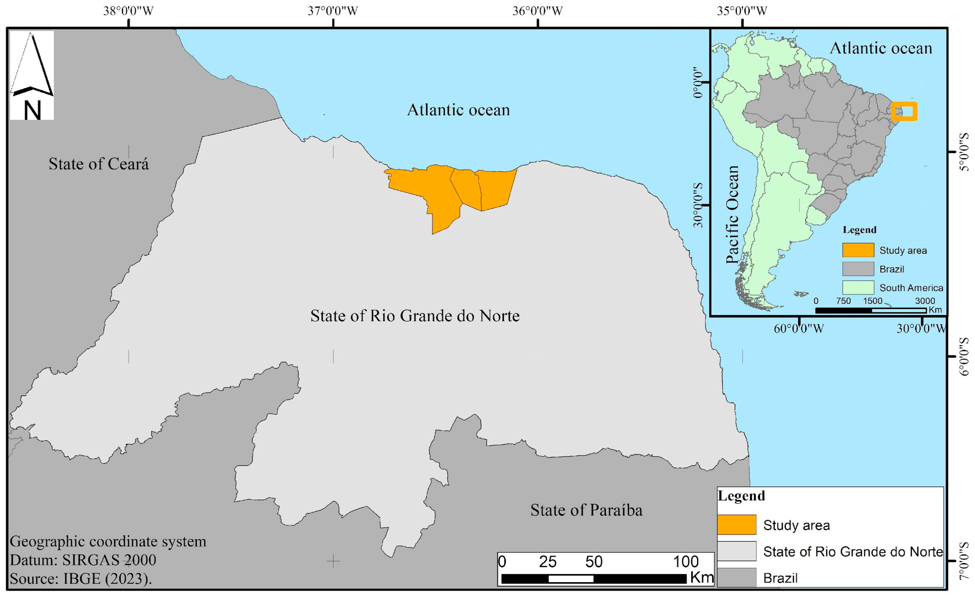
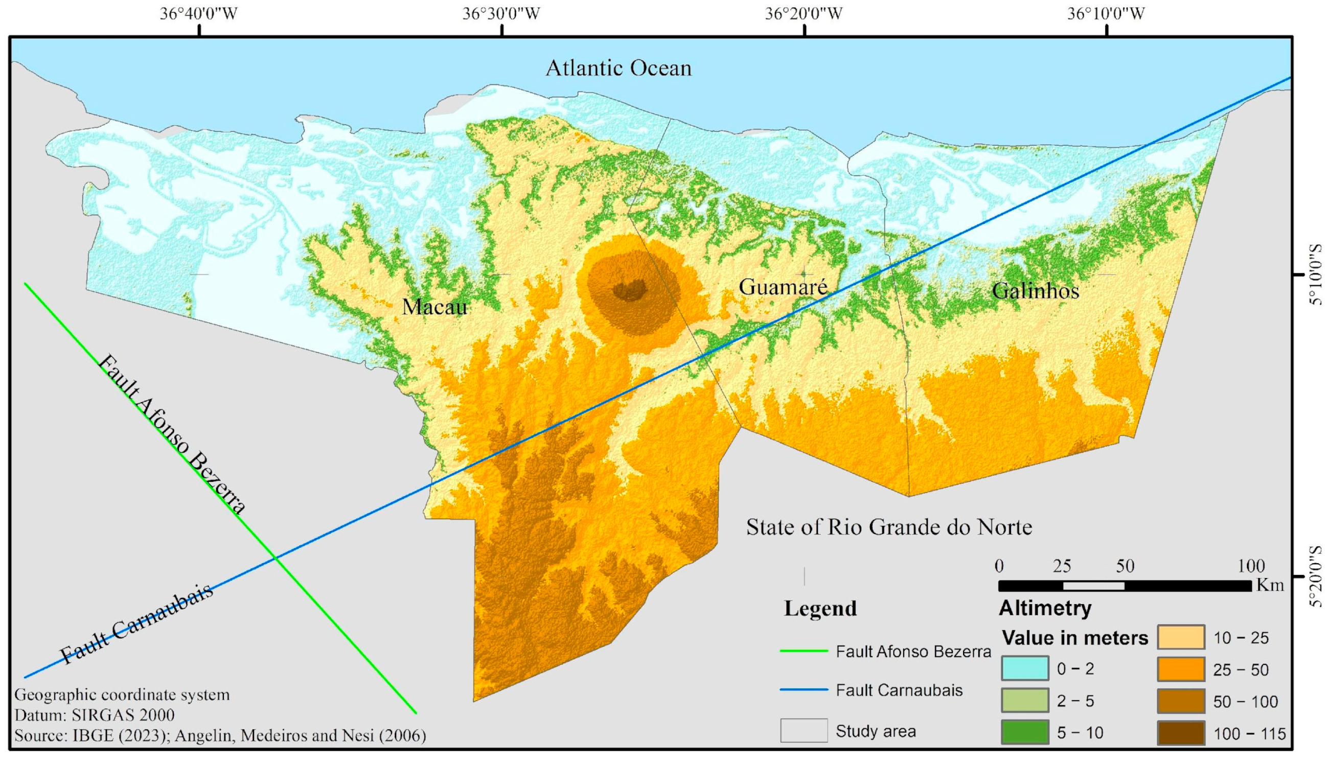
2.1. Study Area

The study area comprises the municipalities of Macau, Galinhos, and Guamaré, located in the central portion of the northern coastline of Rio Grande do Norte, a state in northeastern Brazil (Figure 1). The local economy is primarily based on sea salt extraction, shrimp aquaculture, oil and natural gas exploration, as well as activities in the service sector and tourism. The area has a combined population of 44,768, a population density of 33.56 inhabitants per square kilometer, and an average Human Development Index (HDI) of 0.618 [17].
From a geomorphological perspective, the region is characterized by extensive, low-lying coastal plains (Figure 2), with nearly half of the area lying below 5 m in elevation. Although research on Holocene eustatic oscillations in this region remains limited, existing data suggest that the maximum marine transgression reached approximately 5 m around 5100 years BP [18]. Supporting this, fluvial-estuarine sediments identified in Lagoa do Queimado indicate a historical sea level highstand slightly exceeding 4 m [19]. The highest elevations occur in the central part of the study area, where the Serra do Mangue Seco reaches 115 m above sea level. This major landform is classified as a dome with minimal dissection and has been attributed to structural processes associated with fault systems of the Potiguar Rift, with additional influence from the Macau magmatism [19,20,21,22]. Other elevated surfaces in the study area primarily consist of coastal tablelands.

2.2. Geosites

Previous studies on the geomorphological heritage of this coastal region have focused on geosites in the western sector of the Costa Branca [15,23]. The present study shifts attention to the eastern sector of this coastal segment, analyzing 12 geosites that were previously inventoried based on their scientific value, on the relationship between this value and their potential degradation, and on the representation of different types of coastal processes and landforms [24,25]: hypersaline deserts; Macau magmatism; Ponta do Tubarão estuary; Mangue Seco dome; Minhoto–Amaro beach; Presídio Island; Cabeço da Pescada; Galinhos–Guamaré estuarine system; Galinhos beach; André dunes; Capim dunes; Galinhos aeolianite (Figure 3).

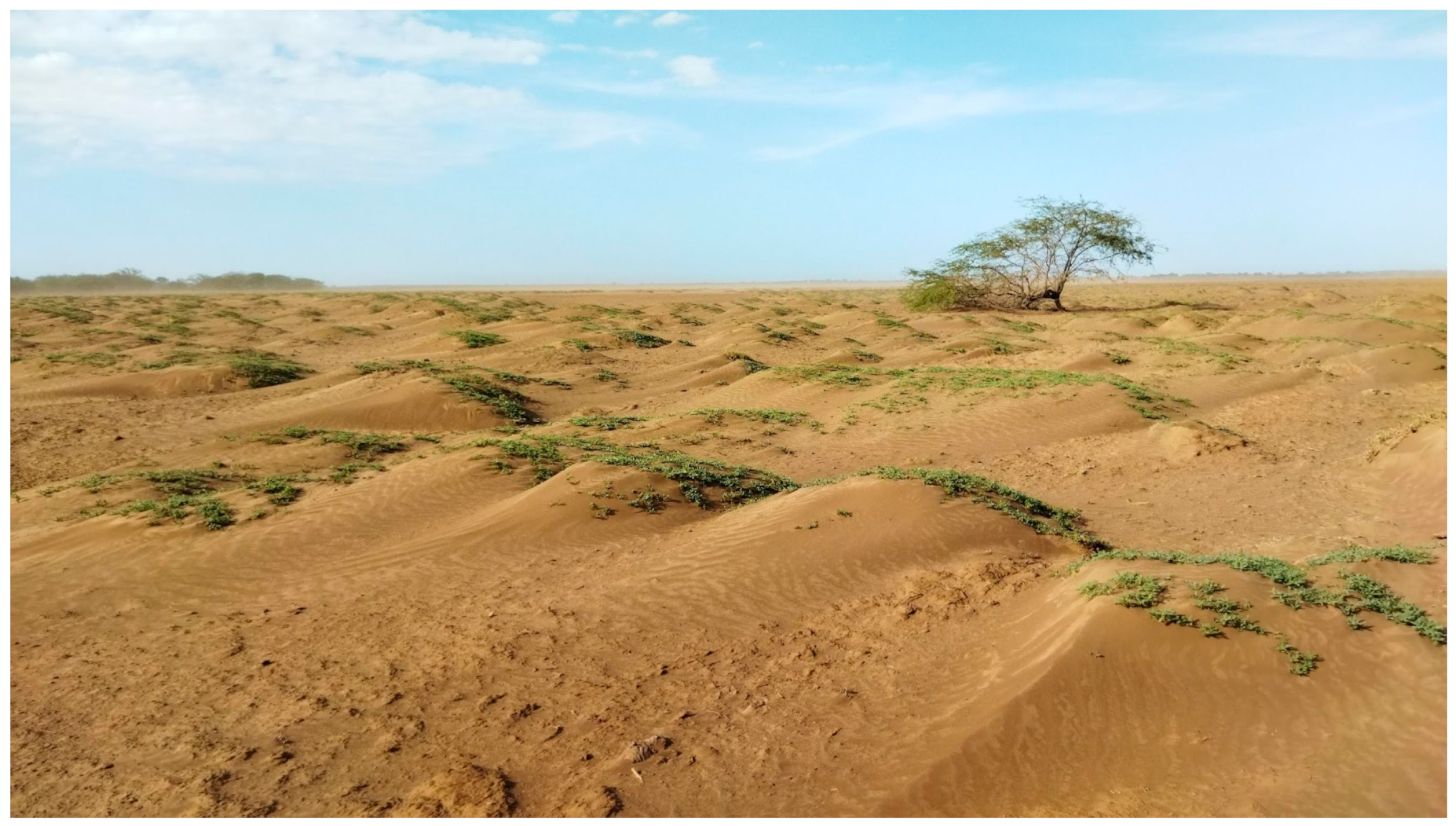
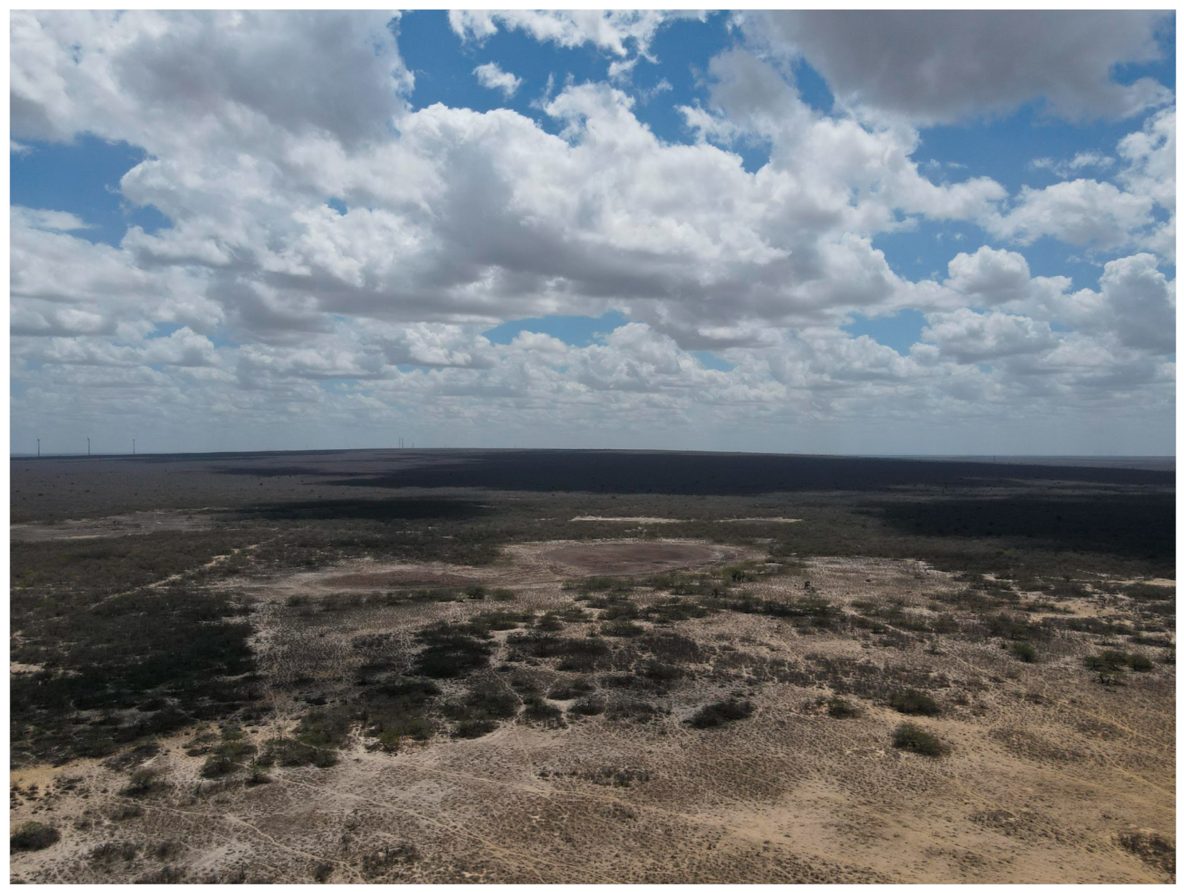
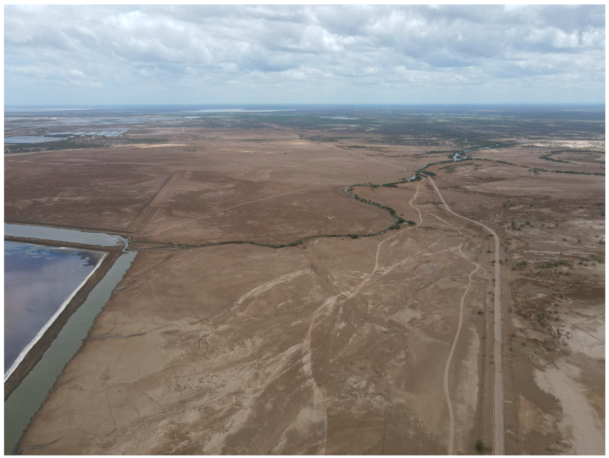
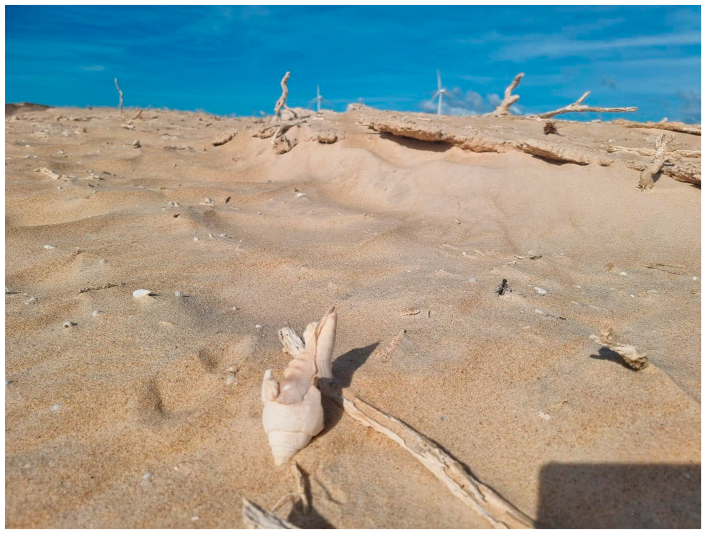
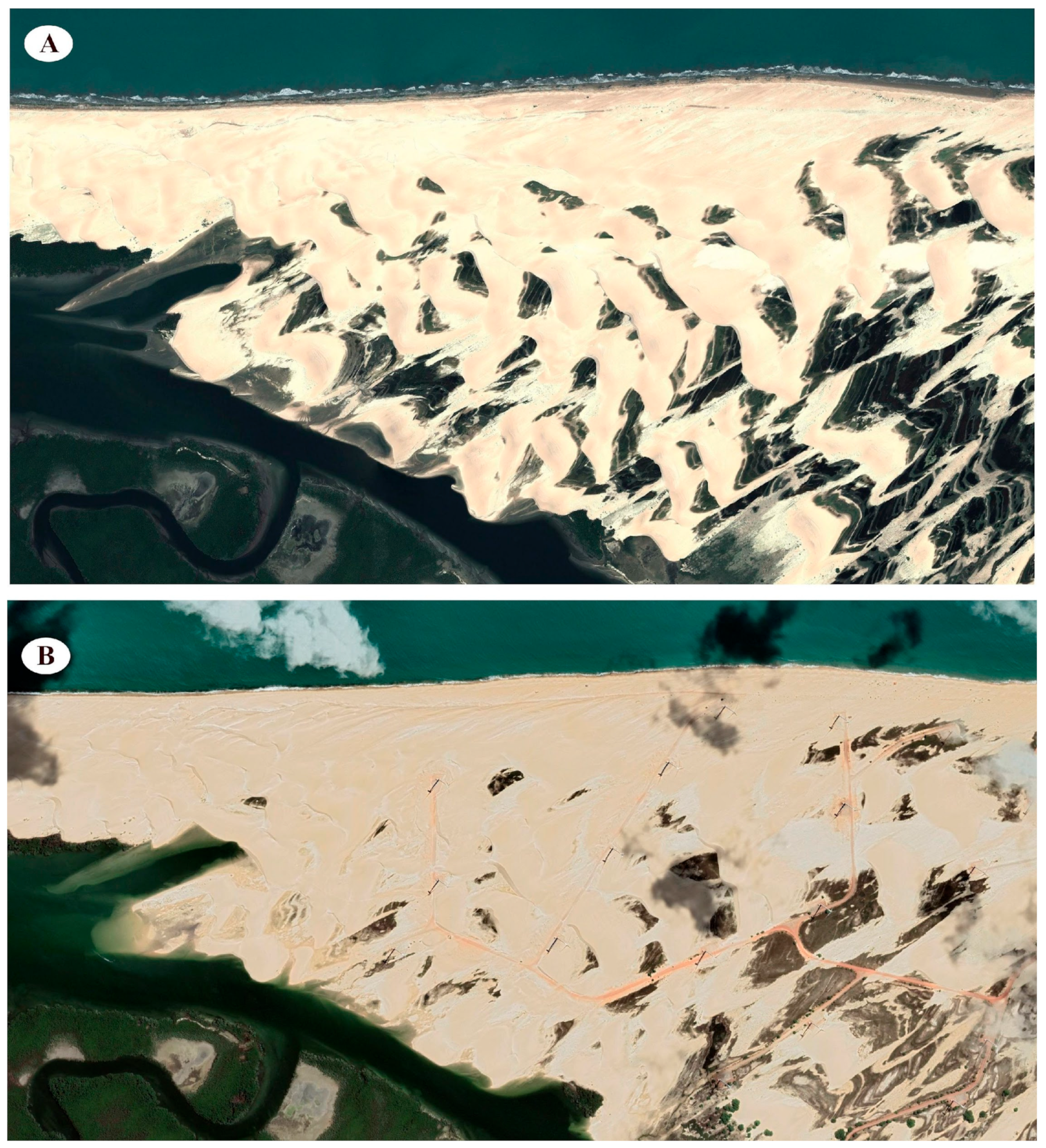
2.2.1. Hypersaline Deserts

The hypersaline deserts correspond to the inland parts of the extensive fluvial–marine plains of the Piranhas–Açu River delta. Owing to the region’s extremely low topography, these areas are inundated by marine waters during spring tides, which contribute to soil salinization. The absence of a well-developed estuarine environment is attributed to the soil’s impermeability, high evaporation rates, and the low discharge of the rivers in the area [24]. Typical mangrove formations are largely absent, occurring only near the riverbeds. As a result, the landscape exhibits desert-like characteristics, including landforms commonly associated with arid environments, such as dunes (Figure 4).
Geodiversity plays a fundamental role in supporting the local economy. The region’s topography—characterized by flat plains, a hot and dry climate, and moderately permeable soils—provides ideal conditions for the development of shrimp farms and evaporation ponds, which are essential for shrimp and sea salt production, respectively. These two activities represent the primary economic drivers, with salt production serving as the cornerstone of regional occupation since the colonial period.
The economic importance of salt production is underscored by the fact that over 95% of Brazil’s salt is produced along the northern coast of Rio Grande do Norte State [26], with the Piranhas–Açu River delta and other estuaries with similar environmental conditions contributing significantly to this output. However, these anthropogenic activities have led to the degradation of a substantial portion of the region’s original mangroves and hypersaline plains.
One of the projected effects of climate change is an increase in saltwater intrusion into coastal areas, likely with greater intensity [27]. Predictive models also indicate a rise in evapotranspiration rates and changes in precipitation patterns, which may lead to higher soil salinity levels [28,29]. The combined effect of these two factors could positively influence the region’s main economic activity: sea salt production. With sea-level rise, salt production is expected to shift inland into currently protected areas, potentially resulting in the near-total occupation of these coastal plains and leading to the degradation of the geosite. The environment will face pressures from both anthropogenic activities associated with the salt industry and climate change. The negative impacts of saltwater intrusion are already evident in some parts of the world [30], where highly valuable agricultural lands are under threat.

2.2.2. Macau Magmatism

The Macau magmatic outcrop is a low hill (Figure 5) that represents the only occurrence of igneous rocks within the study area. Also referred to as the Macau Basalt, this outcrop comprises a suite of mafic rocks—primarily basalts and diabases—originating from both intrusive activity and volcanic overflows within the Tibau Formation [20]. The formation of these rocks is associated with hotspot activity that occurred during the Eocene and Miocene. The site’s geological significance is heightened by the rarity of volcanic events in the region, due to the tectonic stability of the Atlantic coast of northeastern Brazil.

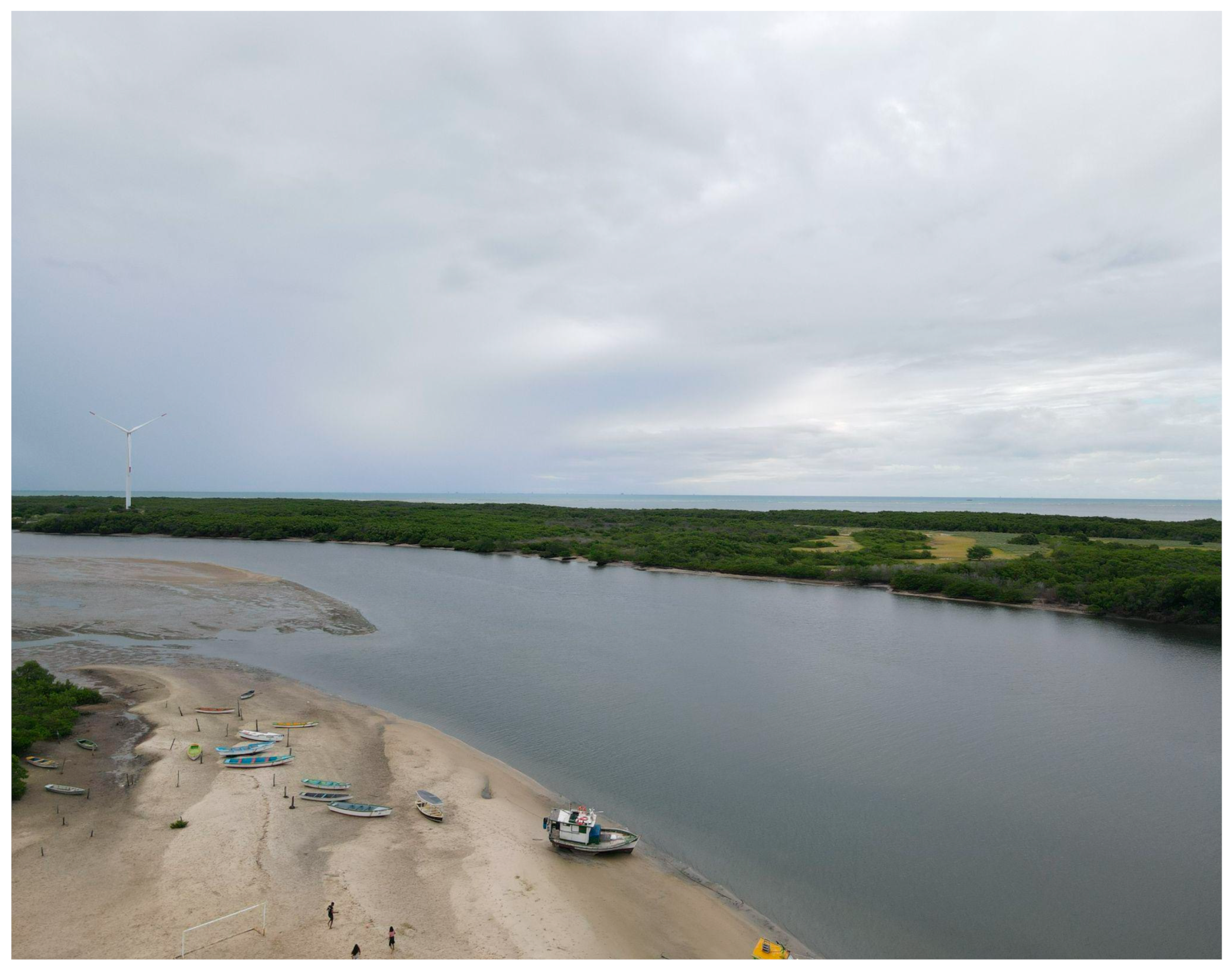
2.2.3. Ponta Do Tubarão Estuary

The Ponta do Tubarão estuary is located within a Sustainable Development Reserve, which is a category of protected area in Brazil that supports traditional populations in conserving nature while promoting sustainable development and improving quality of life. This geosite is characterized by its semi-arid estuarine environment, where freshwater recharge—essential for maintaining continuous flow and the mixing of water masses critical to biodiversity—is sustained primarily by hydrogeological processes [24]. Extensive dune fields absorb rainfall during the wet season, and, due to the low permeability of the materials, the water drains slowly, eventually resurfacing and forming rivers near the coastline (Figure 6).

2.2.4. Mangue Seco Dome

The Mangue Seco dome (Figure 7), also known as Serra do Mangue Seco, is a geomorphological feature characterized by its dome-shaped morphology and relatively low elevation, reaching a maximum altitude of 115 m. Its origin is associated with volcanic activity, a characteristic it shares with the Macau magmatism geosite [24]. However, the two sites differ in typological emphasis: while the significance of the Macau site lies primarily in its igneous rock outcrops, the Mangue Seco dome is notable for its distinctive morphology. In addition to its geological relevance, the site holds economic importance due to oil exploration and its use as a location for wind energy production.

2.2.5. Minhoto–Amaro Beach

The Minhoto–Amaro beach geosite is distinguished by a range of depositional landforms, including coves, sandy spits, a linear beach, and a barrier island located to the north of the shoreline (Figure 8). The site’s uniqueness lies in the dynamic nature of this environment, where the barrier island undergoes continual morphological changes driven by the interaction of waves, tides, and coastal currents. Notably, sediment accumulation to the north of the geosite resulted from dredging activities carried out at the Port of Guamaré in 1983 [31]. The site provides valuable geodiversity services, including flood mitigation and coastal erosion control facilitated by the barrier island, as well as a sheltered recreational area characterized by low wave energy and minimal risk to bathers. These attributes enhance the site’s potential for recreational and tourism activities. Moreover, the area supports wind energy generation, benefiting from consistently favorable wind conditions.

2.2.6. Presídio Island

Presídio Island, covering an area of approximately 0.5 km2, is located north of the municipal center of Guamaré. The geosite’s name (from the Portuguese presídio meaning “prison”) originates from a local practice in which residents would take livestock to graze on the island during low tide, effectively isolating them there. Oriented along an east–west axis, the island is composed of Quaternary depositional sediments formed in a wave- and tide-dominated environment [32]. It features a variety of landforms, including sandbanks to the north, a beach ridge, and a mangrove swamp (Figure 9), which collectively contribute to the island’s morphological stability despite continuous tidal and wave influence, resulting in only minor temporal changes.
The geosite offers significant abiotic ecosystem services, most notably flood control, which helps protect the municipal waterfront, and atmospheric regulation through its interaction with the mangrove system. The site also serves as a freshwater and sediment source that sustains the surrounding mangroves and estuarine environment. Additionally, it supports human activities such as wind energy generation, through the installation of wind turbines, and ecotourism, making it an important site for both environmental and economic sustainability.

2.2.7. Cabeço Da Pescada

The Cabeço da Pescada geosite is a distinctive sandbank located north of Presídio Island, forming part of a group of sandbanks in the area. Unlike some nearby sandbanks that qualify as spits due to their connection to the mainland, Cabeço da Pescada is not classified as such. Its formation is attributed to the deposition of marine and estuarine sediments [31].
A notable feature of this geosite is its periodic exposure: it emerges only during low tide and is submerged at high tide, limiting access for visitors to specific times of the day. The sandbank exhibits a characteristic tongue-shaped morphology (Figure 10) and supports tourism activities only during its brief windows of exposure. The geosite is also marked by pronounced morphological variability, driven by the dynamic interaction of tidal and wave dynamics.

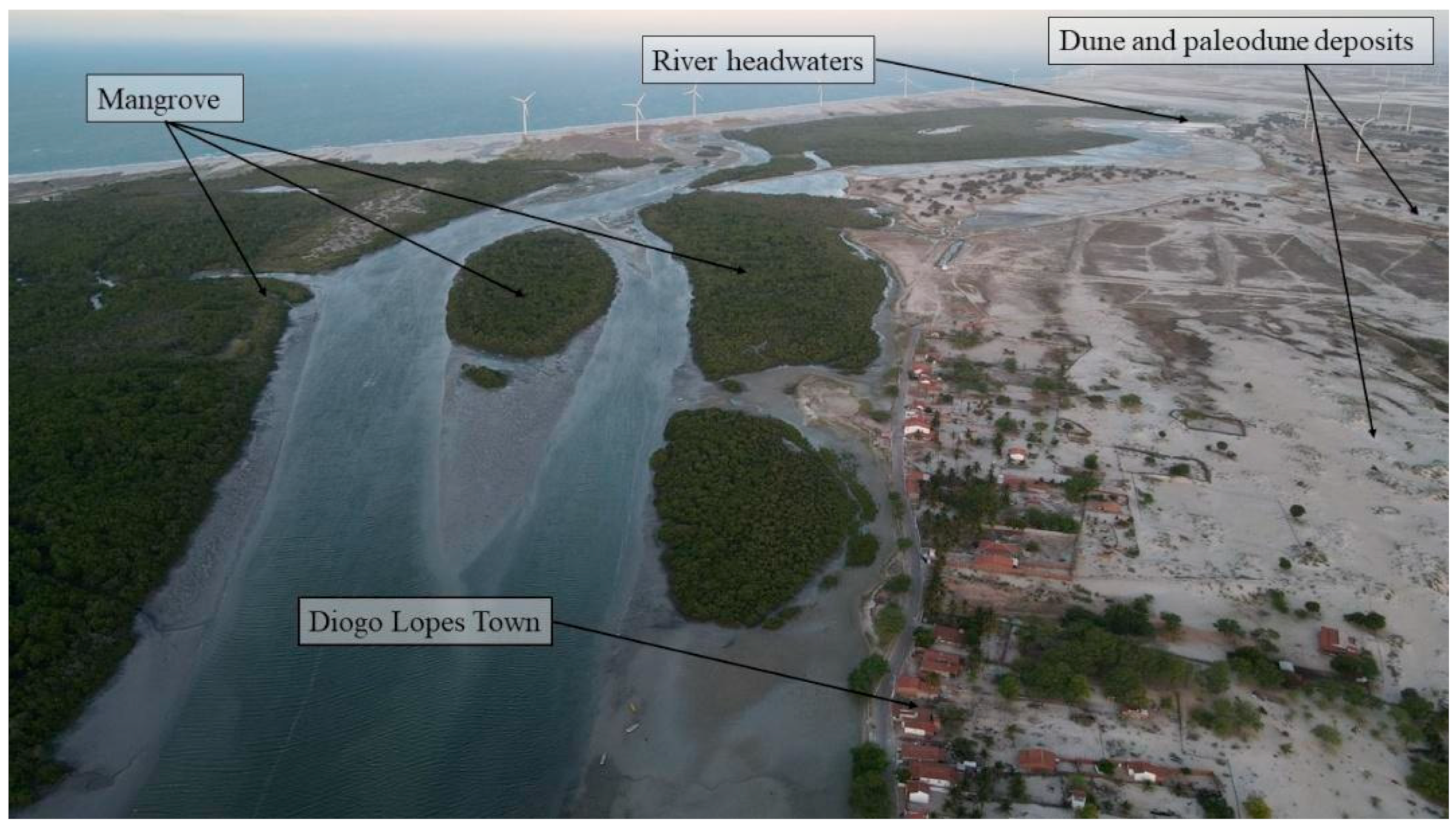
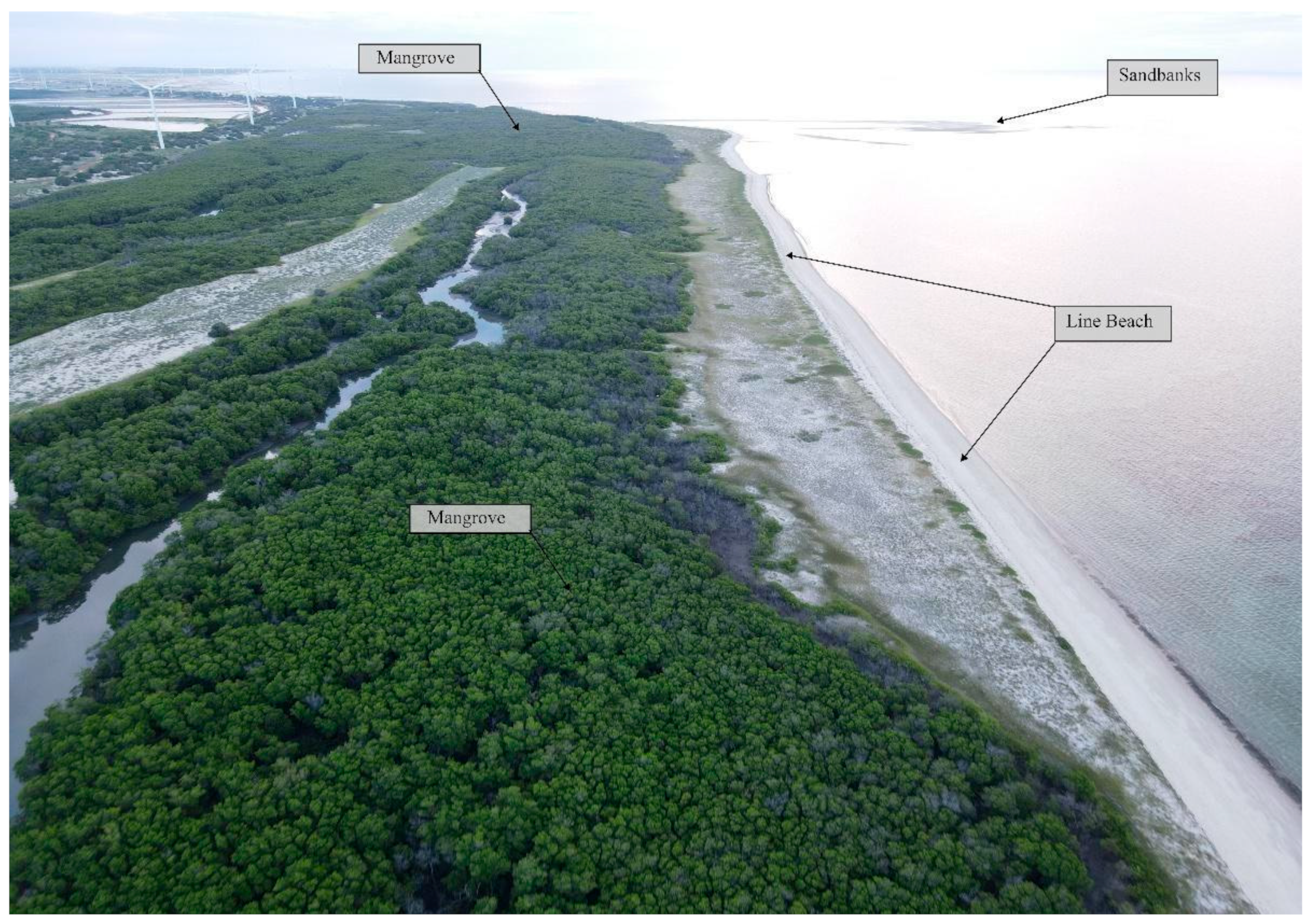
2.2.8. Galinhos–Guamaré Estuarine System

The Galinhos–Guamaré estuarine system is an extensive geosite spanning approximately 35 km2 across the municipalities of Galinhos and Guamaré. It is protected under Brazilian federal legislation [33]. The site encompasses both the estuarine environment and adjacent mangrove swamps (Figure 11). The estuary receives input from a series of predominantly ephemeral rivers, the most notable being the Aratuá, Miassaba, Porto Capim, Camurupim, Pisa Sal, Pratagil, Tomaz, Galinhos, and Volta do Sertão Rivers [34].
The geodiversity of the area supports several critical ecosystem services. These include climate and atmospheric regulation, which contribute to a milder and more hospitable microclimate; the provision of habitats, nutrients, and minerals essential for sustaining local biodiversity—particularly crustaceans and avian species; and support for recreational activities that benefit both residents and tourists through the site’s scenic and ecological appeal. Additionally, the estuarine system underpins key economic activities, such as shrimp farming and artisanal fishing, further emphasizing its environmental and socio-economic value.

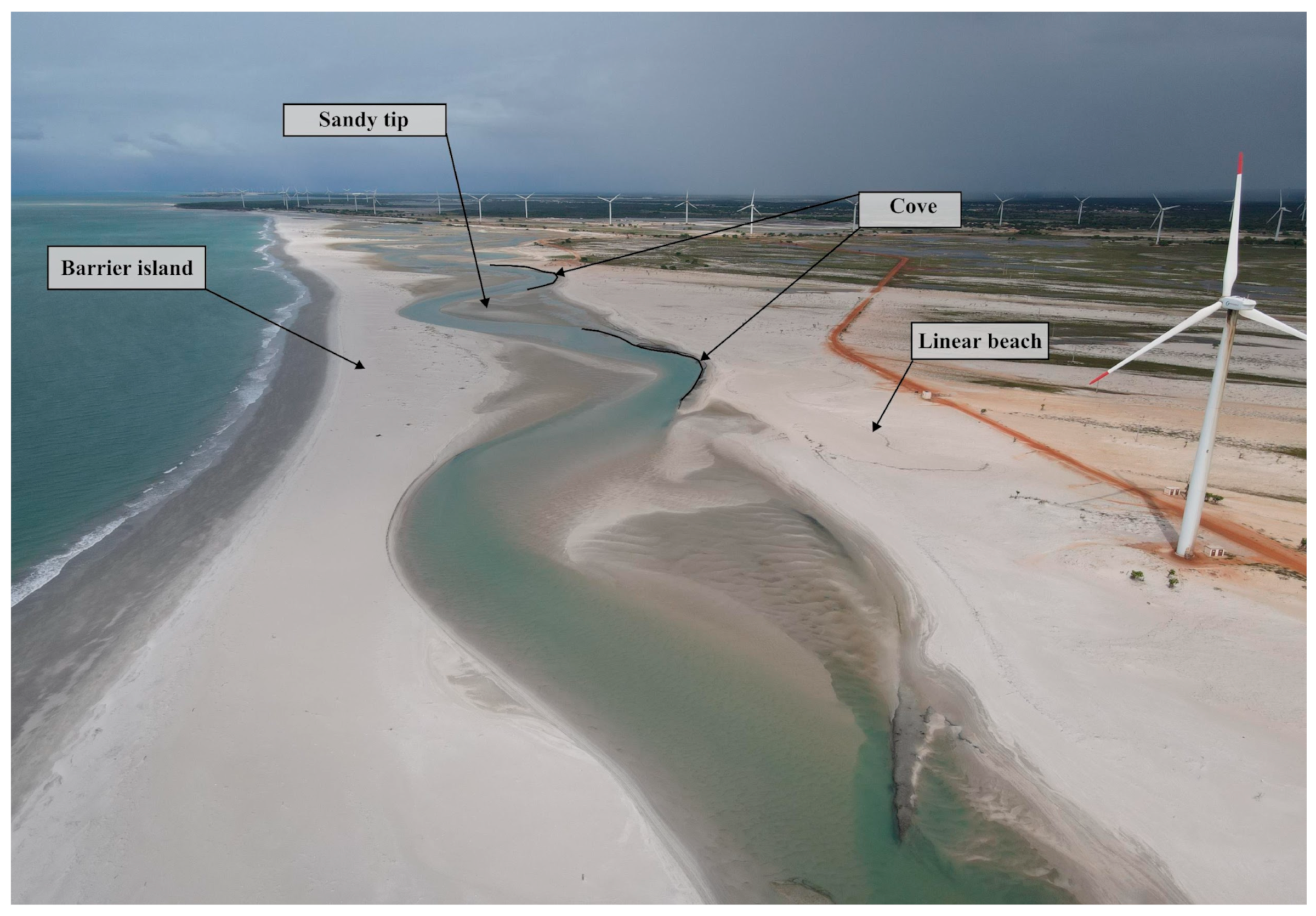
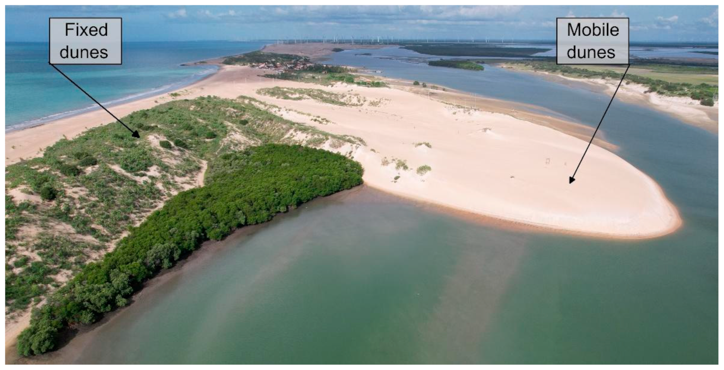
2.2.9. Galinhos Beach
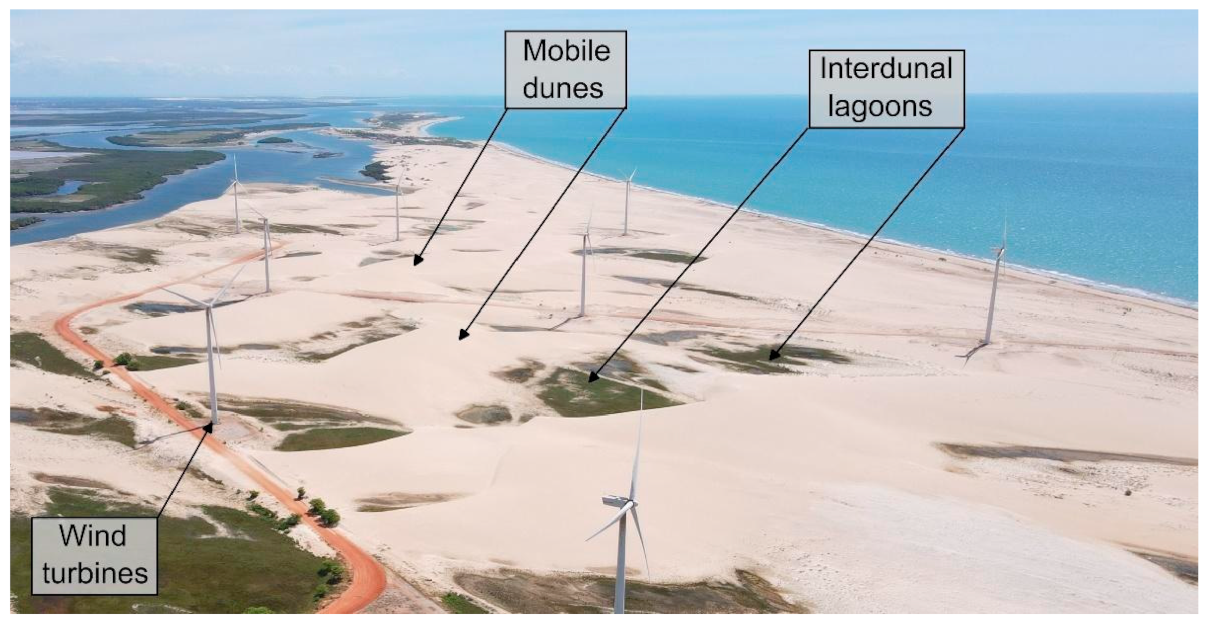
The municipality of Galinhos derives its name from the local name for the “rooster” fish (Selene vomer sp.), a small marine fish referred to as Galinhos (“little roosters”) by local fishermen. The beach is morphologically characterized by a 20-m-wide sand strip, followed by a secondary strip measuring 135 m, and a nearshore zone approximately 45 m wide [35].
The Galinhos beach geosite was inventoried based on the scientific value of its geodiversity features, which include beach rocks, accumulation landforms, and fixed dunes (Figure 12). The site spans approximately 0.6 km2, though it lacks formal legal protection except for the dune area. The geosite provides key ecosystem services, such as freshwater supply through the extraction of groundwater from wells used in the municipal water system, and support for recreational and tourism-related activities. Moreover, the presence of beach rocks contributes to the regulation of flooding and coastal erosion, particularly along the spit where the terrain is low-lying and exhibits a gentle slope of no more than 3%. Herbaceous vegetation in the area acts as a bioindicator of natural instability, reflecting the ongoing influence of wave and tidal dynamics.

2.2.10. André Dunes

The André dunes geosite covers an area of approximately 0.1 km2 and comprises both fixed and mobile dune landforms (Figure 13). Locally known as André hill, the site is named after a former resident who lived in the vicinity of the dunes for many years [36].
The geosite provides key ecosystem services, including wind regulation and the moderation of the ocean-land thermal contrast, which contributes to the formation of sea and land breezes. Additionally, the dunes play a vital role in water regulation through their capacity for natural filtration and groundwater storage.

2.2.11. Capim Dunes

The Capim dunes geosite covers an area of approximately 0.7 km2 and is characterized by an extensive field of mobile dunes interspersed with interdunal lagoons, which are unable to retain water for extended periods, as well as the presence of wind turbines (Figure 14). The site derives its name from the low vegetation—grass—commonly found in the adjacent low-lying areas [36].
Economic activities associated with the site, particularly wind energy generation, contribute significantly to local income. Like the André dunes, this geosite provides essential ecosystem services, including wind regulation, moderation of the ocean–land thermal contrast, water regulation through natural filtration, and support for renewable energy infrastructure.

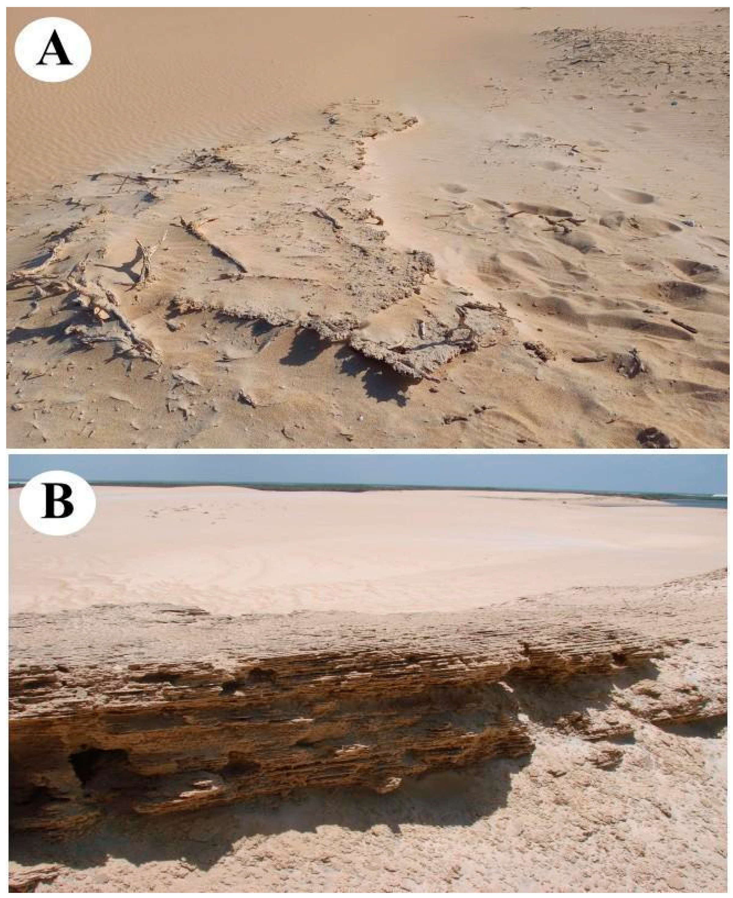
2.2.12. Galinhos Aeolianite

Aeolianites are sedimentary rocks formed through the consolidation of wind-driven deposits [37]. The Galinhos aeolianite is situated near the Capim dunes field and is primarily used for research and educational fieldwork. However, its location along a popular buggy ride route makes it vulnerable to physical degradation caused by tourism-related activities [36].
Additionally, the outcrop undergoes seasonal burial due to aeolian sediment transport and deposition (Figure 15A). This burial process is intermittent, with periodic phases of exhumation that allow for more detailed observation and study of the outcrop’s features (Figure 15B).

2.3. Degradation Risk Assessment

A significant number of geoheritage assessment methodologies has been developed over the past two decades, underscoring the growing importance of this topic within geoconservation research [38]. These methodological proposals aim primarily to ensure objectivity in the assessment process and to generate reliable results that can support the effective management of geosites. Most of these proposals incorporate strong quantitative components, using numerical values to distinguish between sites [39,40]. Moreover, the methodologies span various categories of geoheritage. In this context, specific procedures for assessing geomorphological heritage have been particularly noteworthy [41,42,43,44,45,46], especially those that emphasize its differentiating characteristics, such as aesthetics, dynamics, and the imbrication of scales [47,48,49,50,51,52].
Coastal environments provide exemplary cases of such specificities, given their dynamic landforms and geomorphological processes, which differ significantly from those found in continental interiors. Accordingly, specialized geoheritage assessment methods have been proposed to address the unique characteristics of coastal areas [14,35,36,37]. In this context, the evaluation of degradation risk in coastal environments is especially critical, particularly in regions characterized by low-lying coastlines. These areas are often geodiversity hotspots where marine and terrestrial processes converge and are among the most vulnerable to anthropogenic impacts and global climate change. The heightened vulnerability of low-lying coastal areas reinforces the urgent need for targeted conservation measures and informed management strategies [12,53].
A specific method [14,15] was adopted to assess the degradation of geosites in the study area resulting from both natural and human activities. This approach is grounded in the concepts of fragility, natural vulnerability, anthropogenic vulnerability, and public use [14,54] (Table 1).
The method establishes a quantitative system for assessing the risk of geosite degradation, using a scoring scale from 0 to 3 to represent levels of risk: none, low, medium, and high. It evaluates 11 different sub-criteria grouped under three main criteria—natural vulnerability, anthropogenic vulnerability, and public use (Table 2). The total degradation risk score, derived from the sum of the sub-criteria scores, can range from 0 to 33 points, allowing for a direct interpretation of overall risk.
One possible approach to classifying degradation risk levels is through the use of equitably distributed score ranges. Accordingly, in this study, geosites with a total score below 9 points are classified as being at low risk of degradation. Scores between 9 and 16 indicate moderate risk, while scores from 17 to 24 reflect high risk. Sites scoring 25 points or more are considered to be at very high risk (Table 3). However, it is important to note that the destruction or significant degradation of a geosite may result from a single sub-criterion scoring the maximum value of 3. Therefore, the individual evaluation of each sub-criterion is more critical than the aggregate score. A score of 3 in any specific sub-criterion should be interpreted as an alarm signal, warranting particular attention regardless of the overall or partial criterion scores.
These methodological procedures form part of a sequential workflow that began with the selection of the study area and the geomorphological analysis of the coastal region and its active processes (Figure 16). The geosite inventory enabled the degradation risk assessment to be directed specifically toward these identified locations. At every stage of the research, direct fieldwork and engagement with residents were essential for gaining a deeper understanding of the region’s cultural dynamics and the role of geodiversity in local social and economic practices.

3. Results

The quantitative assessment of degradation risk reveals that all the geosites within the study area are subject to moderate to high levels of degradation (Table 4). Specifically, seven geosites have been classified as facing a moderate risk, while five are categorized as being at high risk of degradation. These findings highlight the need for greater attention to the local and morphological characteristics of low-lying coastal environments, which contribute to their heightened vulnerability.
The hypersaline deserts geosite was classified as having a moderate degradation risk, with a total score of 15 points. This result occurred despite receiving zero points under criterion A, reflecting its high level of natural integrity. However, significant vulnerability was identified in relation to anthropogenic factors. Similarly, the Macau magmatism geosite also received a moderate risk classification, with a score of 15 points. In this case, the distribution of points highlights its natural vulnerability, illustrating how specific environmental and situational attributes directly influence the assessment outcome.
The Mangue Seco dome geosite, by contrast, was categorized as being at high risk of degradation (17 points), despite scoring zero points under criterion A. This finding underscores its pronounced susceptibility to human-induced impacts, as reflected in criteria B and C. The Ponta do Tubarão estuary emerged as the geosite with the highest degradation risk in the study area, with vulnerabilities recorded across all three criteria (A, B, and C). The most critical risks, however, were associated with anthropogenic vulnerability and public use.
The Minhoto–Amaro beach geosite also demonstrated a moderate degradation risk, with a total of 10 points. The main vulnerability stemmed from the public use criterion (9 points), while anthropogenic vulnerability contributed only 1 point. The site is easily accessible via nearby paved and unpaved roads and, despite some degree of physical protection, lacks tourist access restrictions or public management controls. Likewise, the Presídio island geosite was assessed as having a moderate degradation risk (11 points), primarily due to public use vulnerability (10 points) and a minor contribution from anthropogenic vulnerability (1 point). Located less than 500 m from potentially degrading activities, the site includes basic tourist infrastructure but lacks geoheritage protection or visitor access control.
The Cabeço da Pescada geosite, with a total score of 9 points, falls within the moderate degradation risk category. All points were attributed to the public use criterion, primarily due to the absence of legal protection. The site is also subject to morphodynamic processes driven by tidal and wave interactions. The Guamaré–Galinhos estuarine system was classified as being at high risk of degradation, with a total of 19 points. One point was assigned to each of the sub-criteria for natural and anthropogenic vulnerability, while public use accounted for 17 points. This geosite is affected by active processes such as tidal and wave dynamics and is exposed to economic interests that may accelerate degradation. It is located in proximity to human activity, is accessible via a paved road, and is influenced by wind turbine installations and shrimp farming along its margins.
The Galinhos beach geosite was also assessed as having a high degradation risk, with a total score of 17 points. The main vulnerabilities are related to anthropogenic vulnerability (2 points) and public use (15 points), reflecting the site’s economic relevance, particularly in relation to tourism. The site lacks access control and contains several features contributing to its degradation. The André dunes geosite, with a total score of 9 points, falls within the moderate degradation risk category. The primary vulnerability stems from public use (8 points), along with 1 point under anthropogenic vulnerability, largely due to tourism-related economic activities, the absence of visitor control measures, and the presence of structures facilitating access. The Capim dunes geosite, by contrast, is at high risk of degradation, with a total score of 17 points—3 under anthropogenic vulnerability attributed to the development of tourism and wind energy infrastructure, and 14 under public use. The site lacks access control, is situated near residential areas, and exhibits visible signs of ongoing degradation. The Galinhos aeolianite geosite received 11 points, corresponding to a moderate degradation risk. All points were assigned under the public use criterion, reflecting the absence of visitor regulation and active degradation processes, particularly as the site is located within the Capim dunes field.

4. Discussion

The hypersaline deserts geosite is classified as being at medium risk of degradation. This assessment primarily reflects the influence of sub-criteria related to public use (criterion C), as the site received low scores under both natural vulnerability (criterion A) and anthropogenic vulnerability (criterion B). From a natural standpoint, the site exhibits minimal vulnerability due to its location in a geologically and geomorphologically stable environment. The predominance of sedimentary deposition over erosive processes contributes to the persistence and expansion of the hypersaline plains. Similarly, anthropogenic vulnerability is limited, with only sub-criterion B1 (economic interest) receiving a score. This is due to the use of the plains as platforms for the construction of evaporation ponds and tanks, and associated activities such as sea salt production and shrimp farming. In contrast, the public use criterion significantly influences the site’s overall degradation risk. The proximity to human activities, accessibility via paved roads, unregulated transit through the plains, and the absence of physical protection and access control (Figure 17) are the main contributing factors. These elements collectively increase the site’s susceptibility to degradation despite its relative natural and anthropogenic resilience.
The Macau magmatism geosite was also classified as being at medium risk of degradation, with a total score of 15 points. This outcome is primarily attributed to the Natural Vulnerability (A) and Public Use (C) criteria. Sub-criterion A1 received the maximum score (3 points) due to the weathering and erosion processes that pose a significant threat to the preservation of the xenoliths, recognized as the most relevant facies within the outcrop (Figure 18). The sedimentary rocks forming the upper portion of the outcrop are notably friable, and the near-total absence of vegetation cover further exacerbates erosive dynamics. Together, these conditions accelerate surface degradation, increasing the risk of morphological de-characterization and a consequent loss of scientific value.
The substantial score attributed to the Public Use (C) criterion is primarily due to the absence of any form of legal protection for the outcrop, combined with its proximity to activities such as livestock grazing, timber extraction, and recreational use. These include camping and other informal social interactions occurring within the site, all of which contribute to increased pressure and potential degradation of the geosite.
Among all the geosites assessed, the Ponta do Tubarão estuarine system received the highest score, indicating the greatest risk of degradation. The total score of 21 points is primarily attributable to anthropogenic vulnerability (criterion B) and public use (criterion C). Under sub-criterion B1 (economic interest), the site’s topography and water availability render it particularly susceptible to shrimp farming and salt production activities. Regarding criterion C, high scores were recorded in sub-criterion C2 (human proximity), since the village of Diogo Lopes is located within the site’s perimeter (Figure 6); in C3 (accessibility), due to the presence of extensive urban infrastructure; and in C5 (physical protection), which scored the maximum value despite the complete lack of protective measures. The presence of informal walking trails and guided tours led by local residents further underscores a lack of community awareness regarding the importance of geoconservation for sustainable tourism. Additional concerns were identified in sub-criteria C6 and C7, reflecting the site’s susceptibility to multiple degradation pressures, including deforestation, landfilling of estuarine areas, and the construction of both public and private infrastructure, all of which have led to water contamination. A further critical issue is the complete absence of any form of access control.
The Mangue Seco dome geosite is also classified as being at high risk of degradation. The most critical sub-criteria identified were C1, C3, C5, C6, and C7, reflecting the absence of legal protection, the presence of extensive road infrastructure—including highways—and degradation caused by the installation of wind farms and oil extraction facilities.
The Minhoto–Amaro beach geosite presents a moderate risk of degradation. Located in the rural area of the municipality of Guamaré, a region characterized by wind energy production, as evidenced by the numerous wind turbines in the vicinity (Figure 19). The site is highly accessible via paved roads. Although tourist infrastructure is present, particularly in the Amaro sector, there are no physical protection measures or access control in place, significantly increasing the site’s susceptibility to degradation.
The Presídio Island geosite is classified as being at moderate risk of degradation. Despite being protected [33], concerns persist regarding the long-term environmental sustainability of the area and the potential compromise of the geodiversity services it provides, such as flood control and support for human activities (Figure 20). These concerns are largely associated with the impacts of a wind farm installed both in the mangrove swamp and on the island itself. While access to the island is restricted to boat transport—resulting in a score of 0 in sub-criterion C3 (accessibility)—there are no access control measures in place. Moreover, the geosite is located within the urban area of Guamaré, directly across from the municipal port, which increases its exposure to anthropogenic pressures.
The Cabeço da Pescada geosite also presents a moderate risk of degradation. However, the risk related to tourism is minimal due to tidal dynamics, which submerge parts of the sandbank for much of the day. This hydrodynamic behavior inhibits sediment consolidation and results in natural geomorphological changes. The site received low scores in some sub-criteria due to its proximity (less than 1 km) to the Guamaré port and the complete absence of physical protection or access control measures.
The Galinhos–Guamaré estuarine system geosite has been classified as being at high risk of degradation. Located within the boundaries of both municipalities, the site is easily accessible and visible from both the port of Pratagil (Galinhos) and the port of Guamaré. Natural vulnerability has been identified in relation to the proximity of an active geomorphological process (sub-criterion A2) occurring within a tidal channel in the municipality of Galinhos. In this area, a segment of the André dune has been progressively encroaching into the estuarine channel. Over the past decade, this dune has advanced approximately 100 m into the channel (Figure 21), representing a significant contributing factor to the site’s overall degradation risk. Additionally, the establishment of shrimp farming ponds near wind turbine installations—like what has been observed at other sites in the region (Figure 20)—further exacerbates the anthropogenic vulnerability of the geosite. Another use that has been identified as a contributing factor to the observed degradation of the site is the installation of shrimp ponds in close proximity to the wind turbines, as observed in other sites in the same area (Figure 20). The degradation risk is intensified by the absence of visitor management and any formal protection specifically targeting the site’s geodiversity features, despite the area’s legal protection [33], as is also the case for Presídio island.
The Galinhos beach geosite is at high risk of degradation, primarily due to its exposure to two main forms of economic interest. The first is a well-established and intensively promoted tourism industry, with regional and national campaigns that attract visitors from various countries, particularly from Europe and the United States. The second economic activity involves the extraction of materials for local construction. Although currently limited in scope, this practice is common among residents and has the potential to intensify and impact the landscape. The geosite is located less than 100 m from the municipal center, enhancing its accessibility and exposure to anthropogenic pressures. Access to the site involves road travel to the port of Pratagil, followed by a short boat crossing to the municipal seat of Galinhos, from where the geosite can be reached on foot. Boats operate every 30 min and are provided free of charge by the town government to residents and researchers; tourists, however, are required to pay for the service.
There is no control over visitor access or physical protection measures in place to safeguard the local geoheritage, which significantly heightens the risk of degradation from human activities. According to local residents, sports practitioners have been contributing to the deterioration of beachrock formations by using them as platforms for cleaning and maintaining their equipment. Of particular concern is the presence of an informal waste disposal site located within the fixed dunes area (Figure 22). This poses a serious environmental threat, as it may compromise the local groundwater reserves that supply the municipality.
Although the André and Capim dunes geosites exhibit similar morphodynamic characteristics, their respective degradation risks differ: the former is classified as moderate risk, while the latter is considered to be at high risk. The André dunes geosite attracts economic interest primarily from tourism and is accessible via buggy or boat through the tidal channel. Despite the absence of visitor control and physical protection measures, observable signs of degradation are currently limited. The primary concern at this site is the extraction of sandy material by the local community of Galos, located approximately 4 km from the municipal center. This practice, while not yet causing significant environmental impact, warrants ongoing monitoring.
In contrast, the Capim dunes geosite is subject to more intensive anthropogenic disturbance, with tourism serving as the principal economic activity. The site hosts bivalve shells and Calotropis procera plant sub-fossils (Figure 23), commonly referred to as silk flower, silk rose, or beach cotton, among other names [51]. Despite limited accessibility and legal protection [33], extensive evidence points to significant human impact. The establishment of a wind farm in 2013 led to changes in local environmental dynamics (Figure 24). Over the subsequent decade, the interdunal lagoons that once characterized the site have disappeared, substantially diminishing its water retention capacity. Additionally, the geosite lacks effective access control and physical protection mechanisms, further exacerbating its vulnerability.
The Galinhos aeolianite geosite has been classified as being at moderate risk of degradation. Located within the Capim dunes field, the site is particularly vulnerable to the constant traffic of tourist buggies, which follow routes that pass directly over it. This activity contributes to the deterioration of the outcrop, particularly during periods when it is not covered by dune sands and remains exposed.
The application of the method produced satisfactory results in assessing the risk of degradation within the study area. Geosites exhibiting more pronounced evidence of human use correspondingly displayed the highest levels of degradation risk. However, several challenges emerged during the method’s implementation, particularly concerning the number of variables considered at each site to determine the scores assigned to each criterion. A further limitation lies in the absence of a more quantitative assessment of local community perceptions and activities in relation to the degradation of this type of heritage. Although information was gathered from local populations, it was obtained in a non-systematic and qualitative manner. This compromises the reliability of this component of the analysis and underscores the need for a more structured and objective approach in future research.
Moreover, considering the heightened vulnerability of the area to eustatic oscillations, it is essential to integrate climate change implications into the method’s criteria. Incorporating such variables in future adaptations of the method would enhance its effectiveness and allow for more comprehensive analyses that extend beyond low-lying coastal areas to include diverse coastal and continental environments.
Notably, the analysis revealed a profound human impact on coastal degradation, which can be categorized into three distinct forms. Two of these—Public Use and Anthropogenic Vulnerability—are directly assessed by the current method. The third form relates to broader-scale socio-economic infrastructure projects that, although not captured in the current methodology, exert substantial influence on coastal ecosystems. These include impacts ranging from global climate change to the sediment cycle disruptions caused by dam construction, both of which contribute to intensified coastal erosion. All three types of human influence were identified in the study area, with projections suggesting that the broader-scale impacts will likely become more pronounced in the coming decades.
The geosites most susceptible to degradation—Mangue Seco dome, Ponta do Tubarão estuary, Galinhos beach, Capim Dunes, and the Galinhos–Guamaré estuarine system—demonstrated the highest levels of direct human interaction. This finding reinforces the conclusion that human activity constitutes the principal threat to geoheritage in the region. Consequently, it is imperative that sites exhibiting high susceptibility be prioritized for the implementation of access restrictions or protective measures, with the aim of mitigating ongoing and future degradation.

5. Conclusions

The assessment of geosite degradation risk represents a central component of this research, offering concrete insights into previously underdocumented threats to geoheritage. It enabled the identification of geosites most susceptible to degradation and highlighted the extent of societal influence on the ongoing deterioration of these sites.
It was observed that certain criteria employed in the methodology were not perceived as harmful by a significant portion of the local population. However, these factors were found to have a direct and measurable impact on geoheritage degradation. These findings underscore the necessity of advancing geoconservation efforts in the region through the formulation of strategies aimed at promoting socio-environmental sustainability in the short, medium, and long term. The timeframe for implementing such strategies should be determined based on the specific degree of degradation observed at each geosite.
Although environmental regulations established by the state of Rio Grande do Norte, as well as those under Brazilian federal law, impose strict limitations on the degradation of natural environments, enforcement remains inconsistent and, in many cases, ineffective. Of particular concern is the installation of wind turbines in or near geosite areas, which poses significant risks to geoheritage and stands in clear contradiction to existing legal frameworks.
The methodological approach adopted in this study demonstrates applicability beyond the current case study, especially in other low-lying coastal areas facing the growing threat of sea-level rise. The analysis reinforces that many geosites in the study area—particularly those located at the land-sea interface—are highly susceptible to the effects of rising sea levels. Recent trends and indicators of eustatic sea-level change further support the urgency of addressing these vulnerabilities through integrative conservation and management strategies.
Despite the valuable findings, several limitations were encountered, underscoring the methodological and contextual challenges associated with assessing geoheritage vulnerability in low-lying coastal environments.
A significant obstacle lies in the scarcity of scientific literature and standardized methodologies specifically tailored to evaluating geoheritage vulnerability in such coastal settings. This gap hinders a comprehensive understanding of the range and intensity of climate change impacts on these fragile systems. Compounding this issue is the lack of high-resolution topographic data across the study area, which constrains the ability to model projected sea-level rise and delineate zones of coastal erosion or flood susceptibility with precision. Although some studies provide valuable insights into the region’s paleo-landscape, these datasets are limited in spatial scope—often focused on estuarine zones—and temporally outdated. This restricts the ability to reconstruct broader environmental dynamics and evolution over time.
Furthermore, the integration of community-based knowledge and perceptions remains constrained by the absence of a systematic, quantitative framework. Current findings rely largely on qualitative and informal data surveys, highlighting the need for more structured and replicable approaches to capturing local insights into geoheritage use and degradation. Together, these challenges point to clear opportunities for advancing future research.
This study underscores the critical importance of raising awareness among local authorities regarding the necessity of developing and implementing public policies aimed at geosite conservation and the mitigation of adverse human impacts. Future efforts should also prioritize the education and engagement of local communities regarding the impacts of their activities on geosites and the broader societal value of geoheritage preservation. Consequently, the development and implementation of sustainable management strategies for the study area’s geoheritage are essential. These strategies must be integrated into municipal, state, and federal public policies to ensure coherence and long-term effectiveness.

Author Contributions

Conceptualization, M.T.M.D., F.E.B.d.S. and M.D.d.C.; methodology, M.T.M.D., F.E.B.d.S. and M.D.d.C.; validation, M.T.M.D., F.E.B.d.S. and M.D.d.C.; investigation, M.T.M.D., F.E.B.d.S. and M.D.d.C.; data curation, F.E.B.d.S. and M.D.d.C.; writing—original draft, F.E.B.d.S. and M.D.d.C.; writing—review and editing, F.E.B.d.S., M.D.d.C., M.T.M.D. and P.P.; supervision, M.T.M.D. and P.P. All authors have read and agreed to the published version of the manuscript.

Funding

National Council for Scientific and Technological Development (CNPq) and Coordination for the Improvement of Higher Education Personnel—Brazil (CAPES).

Institutional Review Board Statement

Not applicable.

Informed Consent Statement

Not applicable.

Data Availability Statement

The original contributions presented in this study are included in the article. Further inquiries can be directed to the corresponding author.

Conflicts of Interest

The authors declare no conflict of interest.

References

  1. Crofts, R.; Gordon, J.E.; Brilha, J.; Gray, M.; Gunn, J.; Larwood, J.; Santucci, V.L.; Tormey, D.; Worboys, G.L. Guidelines for Geoconservation in Protected and Conserved Areas; Best Practice Protected Area Guidelines Series No. 31; IUCN: Gland, Switzerland, 2020. [Google Scholar]
  2. Gordon, J.E.; Barron, H.F. The role of geodiversity in delivering ecosystem services and benefits in Scotland. Scott. J. Geol. 2013, 49, 41–58. [Google Scholar] [CrossRef]
  3. Neumann, B.; Ott, K.; Kenchington, R. Strong sustainability in coastal areas: A conceptual interpretation of SDG 14. Sustain. Sci. 2017, 12, 1019–1035. [Google Scholar] [CrossRef] [PubMed]
  4. Henriques, M.H.; Castro, A.R.S.F.; Félix, Y.R.; Carvalho, I.S. Promoting sustainability in a low density territory through geoheritage: Casa da Pedra case-study (Araripe Geopark, NE Brazil). Resour. Policy 2020, 67, 101684. [Google Scholar] [CrossRef]
  5. Cengiz, C.; Şahin, Ş.; Cengiz, B.; Başkır, M.B.; Dağlı, P.K. Evaluation of the visitor understanding of coastal geotourism and geoheritage potential based on sustainable regional development in western Black Sea Region, Turkey. Sustainability 2021, 13, 11812. [Google Scholar] [CrossRef]
  6. Newsome, D.; Dowling, R.K. (Eds.) Geotourism: The Tourism of Geology and Landscape; Goodfellow Publishers: Oxford, UK, 2010. [Google Scholar]
  7. Rosado-González, E.M.; Palacio-Prieto, J.L.; Sá, A.A. Geotourism in Latin America and Caribbean UNESCO Global Geoparks: Contribution for Sustainable Development Goals. In Technological Progress, Inequality and Entrepreneurship; From Consumer Division to Human Centricity; Ratten, V., Ed.; Springer: Cham, Switzerland, 2020; pp. 107–121. [Google Scholar] [CrossRef]
  8. Sustainable Development Goals. Available online: https://www.un.org/sustainabledevelopment/ (accessed on 23 January 2025).
  9. Khoso, R.B.; Negri, A.; Guerini, M.; Mantovani, A.; Shajahan, R.; Gentilini, S.; Perotti, L.; Giardino, M. The virtuous circle of geodiversity: Application of geoscience knowledge for sustainability in the framework of the International Geodiversity Day. Quaest. Geogr. 2024, 43, 95–120. [Google Scholar] [CrossRef]
  10. Arias-Díaz, A.; Murcia, H.; Vallejo-Hincapié, F.; Németh, K. Understanding geodiversity for sustainable development in the Chinchiná River Basin, Caldas, Colombia. Land 2023, 12, 2053. [Google Scholar] [CrossRef]
  11. Chakraborty, A. Geodiversity and tourism sustainability in the Anthropocene. Tour. Hosp. 2022, 3, 496–508. [Google Scholar] [CrossRef]
  12. Nicholls, R.J.; Wong, P.P.; Burkett, V.R.; Codignotto, J.; Hay, J.E.; McLean, R.; Ragoonaden, S.; Woodroffe, C.D. Coastal systems and low-lying areas. In Climate Change 2007: Impacts, Adaptation and Vulnerability; Contribution of Working Group II to the Fourth Assessment Report of the Intergovernmental Panel on Climate, Change; Parry, M.L., Canziani, O.F., Palutikof, J.P., van der Linden, P.J., Hanson, C.E., Eds.; Cambridge University Press: Cambridge, UK, 2007; pp. 315–356. [Google Scholar]
  13. Tucker, J.; Daoud, M.; Oates, N.; Few, R.; Conway, D.; Mtisi, S.; Matheson, S. Social vulnerability in three high-poverty climate change hot spots: What does the climate change literature tell us? Reg. Environ. Change 2015, 15, 783–800. [Google Scholar] [CrossRef]
  14. Selmi, L.; Canesin, T.S.; Gauci, R.; Pereira, P.; Coratza, P. Degradation Risk Assessment: Understanding the Impacts of Climate Change on Geoheritage. Sustainability 2022, 14, 4262. [Google Scholar] [CrossRef]
  15. Rabelo, T.O.; Diniz, M.T.M.; de Araújo, I.G.D.; Terto, M.L.d.O.; Queiroz, L.S.; Araújo, P.V.d.N.; Pereira, P. Risk of degradation and coastal flooding hazard on geoheritage in protected areas of the semi-arid coast of Brazil. Water 2023, 15, 2564. [Google Scholar] [CrossRef]
  16. Vandelli, V.; Selmi, L.; Faccini, F.; Ferrando, A.; Coratza, P. Geoheritage Degradation Risk Assessment: Methodologies and Insights. Sustainability 2024, 16, 10336. [Google Scholar] [CrossRef]
  17. Instituto Brasileiro de Geografia e Estatística (Brazilian Institute of Geography and Statistics). Available online: https://www.ibge.gov.br (accessed on 20 January 2025).
  18. Suguio, K.; Martin, L.; Bittencourt, A.C.S.P.; Domingues, J.M.L.; Flexor, J.-M.; Azevedo, A.E.G.d. Flutuações do nível relativo do mar durante o Quaternário superior ao longo do litoral brasileiro e suas implicações na sedimentação costeira. Rev. Bras. Geosci. 1985, 15, 273–286. (In Portuguese) [Google Scholar] [CrossRef]
  19. Barbosa, M.E.F.; Boski, T.; Bezerra, F.H.R.; Lima-Filho, F.P.; Gomes, M.P.; Pereira, L.C.; Maia, R.P. Late Quaternary infilling of the Assu River embayment and related sea level changes in NE Brazil. Mar. Geol. 2018, 405, 23–37. [Google Scholar] [CrossRef]
  20. Bezerra, F.H.; Amaral, R.F.; Silva, F.O.; Sousa, M.O.; Vieira, M.M.; Lima, E.N.; Fonseca, V.P. Nota Explicativa da Folha Macau, SB. 24-XD-II; CPRM—Serviço Geológico do Brasil: Rio de Janeiro, Brazil, 2009. (In Portuguese) [Google Scholar]
  21. Angelin, L.A.; Medeiros, V.C.; Nesi, J.R. Programa Geologia do Brasil—PGB. Projeto Geologia e Recursos Minerais do Estado do Rio Grande do Norte; Mapa geológico do Estado do Rio Grande do Norte. Escala. 1:500,000; CPRM/FAPERN: Recife, Brasil, 2006. (In Portuguese) [Google Scholar]
  22. Bezerra, F.H.; Marques, F.O.; Vasconcelos, D.L.; Rossetti, D.F.; Tavares, A.C.; Maia, R.P.; de Castro, D.L.; Nogueira, F.C.; Fuck, R.A.; Medeiros, W.E. Review of tectonic inversion of sedimentary basins in NE and N Brazil: Analysis of mechanisms, timing and effects on structures and relief. J. S. Am. Earth Sci. 2023, 126, 104356. [Google Scholar] [CrossRef]
  23. Diniz, M.T.M.; Terto, M.L.d.O.; da Silva, F.E.B. Assessment of the geomorphological heritage of the Costa Branca area, a potential geopark in Brazil. Resources 2023, 12, 13. [Google Scholar] [CrossRef]
  24. Silva, F.B. Geopatrimônio dos Municípios de Porto do Mangue e Macau-RN. Master’s Thesis, Federal University of Rio Grande do Norte, Natal, Brazil, 2022. (In Portuguese). [Google Scholar]
  25. Chagas, M.D. Avaliação do Patrimônio Geomorfológico dos Municípios de Guamaré e Galinhos-RN. Master’s Thesis, Federal University of Rio Grande do Norte, Natal, Brazil, 2023. (In Portuguese). [Google Scholar]
  26. Diniz, M.T. Condicionantes Socioeconômicos e Naturais para a Produção de sal Marinho No Brasil: As Particularidades da Principal Região Produtora. Ph.D. Thesis, Ceará State University, Fortaleza, Brazil, 2013. (In Portuguese). [Google Scholar]
  27. Hassani, A.; Azapagic, A.; Shokri, N. Global predictions of primary soil salinisation under climate change in the 21st century. Nat. Commun. 2021, 12, 6663. [Google Scholar] [CrossRef]
  28. Karmakar, R.; Das, I.; Dutta, D.; Rakshit, A. Potential effects of climate change on soil properties: A review. Sci. Int. 2016, 4, 51–73. [Google Scholar] [CrossRef]
  29. Shi, Z.; Wang, N.; Chen, S.; Huang, J.; Taghizadeh, R.; Peng, J.; Wigneron, J.; Frappart, F. Soil Salinization Trend from 2003 to 2022 across the Globe Response to Climate Change. Res. Sq. 2024, 1, 1–24. [Google Scholar] [CrossRef]
  30. Nhung, T.T.; Vo, P.L.; Nghi, V.V.; Bang, H.Q. Salt intrusion adaptation measures for sustainable agricultural development under the effects of climate change: A case of Ca Mau Peninsula, Vietnam. Clim. Risk Manag. 2019, 23, 88–100. [Google Scholar] [CrossRef]
  31. Silveira, I.M.d.; Vital, H.; Amaro, V.E.; Sousa, M.E.; Chaves, M.S. The evolutionary study of environmental conditions of the Guamaré coast (northeastern Brazil). J. Coast. Res. 2006, 1, 237–241. [Google Scholar]
  32. Silva, A.G.A.; Vital, H. Estimation of Presídio’s Barrier Island (Guamaré-NE/Brazil) Migration by Means of GIS and Remote Sensing. Coastline Rep. 2010, 16, 47–50. [Google Scholar]
  33. Brasi. Novo Código Florestal. Lei 12.651 de 25 de maio de 2012. Presidência da República. Casa Civil. Subchefia para Assuntos Jurídicos. 2017. (In Portuguese)
  34. Costa Neto, L.X. Caracterização Geológica, Geomorfológica e Oceanográfica do Sistema Pisa Sal, Galinhos/RN—Nordeste do Brasil, Com Ênfase à Erosão, ao Transporte e à Sedimentação. Ph.D. Thesis, Federal University of Rio Grande do Norte, Natal, Brazil, 2009. (In Portuguese). [Google Scholar]
  35. Lima, Z.M.C.; Vital, H.; Tabosa, W.F. Morphodynamic variability of the Galinhos Spit, northeastern Brazil. J. Coast. Res. 2006, 1, 598–601. [Google Scholar]
  36. Silva, M.D.V.; Lima, M.Z.; Nascimento, M.A.L. Qualitative assessment of the geomorphological heritage of Galinhos spit, in the northern coastal zone of Rio Grande do Norte. Northeast. Geosci. J. 2020, 6, 306–318. [Google Scholar]
  37. Sayles, R.W. Bermuda during the ice age. Proc. Am. Acad. Arts Sci. 1931, 66, 381–486. [Google Scholar] [CrossRef]
  38. Herrera-Franco, G.; Carrión-Mero, P.; Montalván-Burbano, N.; Caicedo-Potosí, J.; Berrezueta, E. Geoheritage and Geosites: A Bibliometric Analysis and Literature Review. Geosciences 2022, 12, 169. [Google Scholar] [CrossRef]
  39. Brilha, J. Inventory and Quantitative assessment of geosites and geodiversity sites: A review. Geoheritage 2016, 8, 119–134. [Google Scholar] [CrossRef]
  40. Brilha, J. Geoheritage: Inventories and Evaluation. In Geoheritage: Assessment, Protection, and Management; Reynard, E., Brilha, J., Eds.; Elsevier: Amsterdam, The Netherlands, 2018; pp. 69–85. [Google Scholar] [CrossRef]
  41. Pereira, P.; Pereira, D. Methodological guidelines for geomorphosite assessment. Géomorphologie Relief Process. Environ. 2010, 16, 215–222. [Google Scholar] [CrossRef]
  42. Reynard, E.; Fontana, G.; Kozlik, L.; Scapozza, C. A method for assessing “scientific” and “additional values” of geomorphosites. Geogr. Helv. 2007, 62, 148–158. [Google Scholar] [CrossRef]
  43. Reynard, E.; Perret, A.; Bussard, J.; Grangier, L.; Martin, S. Integrated Approach for the Inventory and Management of Geomorphological Heritage at the Regional Scale. Geoheritage 2016, 8, 43–60. [Google Scholar] [CrossRef]
  44. Mucivuna, V.C.; Garcia, M.d.G.M.; Reynard, E. Comparing quantitative methods on the evaluation of scientific value in geosites: Analysis from the Itatiaia National Park, Brazil. Geomorphology 2022, 396, 107988. [Google Scholar] [CrossRef]
  45. Diniz, M.T.M.; de Araújo, I.G.D. Proposal of a quantitative assessment method for viewpoint geosites. Resources 2022, 11, 115. [Google Scholar] [CrossRef]
  46. da Costa, H.L.; Diniz, M.T.M.; Xavier, R.A.; Queiroz, L.S.; Maia, R.P. Quantitative assessment of the geomorphological heritage of the Pedra da Boca State Park’s surroundings: Key geoheritage site in Northeast Brazil. Int. J. Geoheritage Park. 2023, 11, 433–449. [Google Scholar] [CrossRef]
  47. Reynard, E.; Panizza, M. Geomorphosites: Definition, assessment and mapping. Géomorphologie Relief Process. Environ. 2005, 11, 177–180. [Google Scholar] [CrossRef]
  48. Coratza, P.; Hobléa, F. The specificities of geomorphological heritage. In Geoheritage: Assessment, Protection, and Management; Reynard, E., Brilha, J., Eds.; Elsevier: Amsterdam, The Netherlands, 2018; pp. 87–106. [Google Scholar] [CrossRef]
  49. Mucivuna, V.C.; Reynard, E.; Garcia, M.d.G.M. Geomorphosites Assessment Methods: Comparative Analysis and Typology. Geoheritage 2019, 11, 1799–1815. [Google Scholar] [CrossRef]
  50. Brocx, M.; Semeniuk, V. Geoheritage and geoconservation—History, definition, scope and scale. J. R. Soc. West. Aust. 2007, 90, 53–87. [Google Scholar]
  51. Diniz, M.T.M.; de Araújo, I.G.D.; das Chagas, M.D. Comparative study of quantitative assessment of the geomorphological heritage of the coastal zone of Icapuí-Ceará, Brazil. Int. J. Geoheritage Park. 2022, 10, 124–142. [Google Scholar] [CrossRef]
  52. Rabelo, T.O. Geoconservação e Risco de Degradação em Ambientes Costeiros: Uma Proposta de Avaliação do Geopatrimônio Costeiro dos Municípios de Raposa-MA e Galinhos-RN. Ph.D. Thesis, Federal University of Rio Grande do Norte, Natal, Brazil, 2022. (In Portuguese). [Google Scholar]
  53. Gray, M. Geodiversity: Developing the paradigm. Proc. Geol. Assoc. 2008, 119, 287–298. [Google Scholar] [CrossRef]
  54. García-Ortiz, E.; Fuertes-Gutiérrez, I.; Fernández-Martínez, E. Concepts and terminology for the risk of degradation of geological heritage sites: Fragility and natural vulnerability, a case study. Proc. Geol. Assoc. 2014, 125, 463–479. [Google Scholar] [CrossRef]
Figure 1. Location of the municipalities of Macau, Guamaré, and Galinhos in the central segment of the northern coastline of the Rio Grande do Norte state, northeastern Brazil.
Sustainability 17 06709 g001
Figure 2. Altitude of the municipalities of Macau, Guamaré, and Galinhos, with emphasis on the vast coastal area below 2 m.
Sustainability 17 06709 g002
Figure 3. Location of the geosites inventoried in the municipalities of Macau, Guamaré, and Galinhos, Rio Grande do Norte, northeastern Brazil.
Sustainability 17 06709 g003
Figure 4. Formation of embryonic dunes at the hypersaline deserts geosite. The dunes are composed of sediments from the Piranhas-Açu estuary, including clay, silt, and sand.
Sustainability 17 06709 g004
Figure 5. Macau magmatism geosite: aerial view of the hill (A); basalts outcropping (B).
Sustainability 17 06709 g005
Figure 6. Aerial view of the Ponta do Tubarão estuary geosite.
Sustainability 17 06709 g006
Figure 7. Aerial view of the Mangue Seco Dome geosite.
Sustainability 17 06709 g007
Figure 8. Aerial view of the Minhoto–Amaro beach geosite.
Sustainability 17 06709 g008
Figure 9. Aerial view of the Presídio Island geosite.
Sustainability 17 06709 g009
Figure 10. Aerial view of the Cabeço da Pescada geosite.
Sustainability 17 06709 g010
Figure 11. Aerial view of the Galinhos–Guamaré estuarine system geosite.
Sustainability 17 06709 g011
Figure 12. Aerial view of the Galinhos beach geosite.
Sustainability 17 06709 g012
Figure 13. Aerial view of the André dunes geosite.
Sustainability 17 06709 g013
Figure 14. Aerial view of the Capim dunes geosite.
Sustainability 17 06709 g014
Figure 15. Galinhos aeolianite geosite: buried by dune sand, in 2023 (A); outcropping in 2019 (B); photo by Maria da Vitória da Silva.
Sustainability 17 06709 g015
Figure 16. Methodological framework for assessing the degradation risk of geosites inventoried in the municipalities of Macau, Guamaré, and Galinhos, Rio Grande do Norte, northeastern Brazil.
Sustainability 17 06709 g016
Figure 17. Evidence of degradation caused by human activity identified at the hypersaline deserts geosite.
Sustainability 17 06709 g017
Figure 18. Evidence of degradation identified at the Macau magmatism geosite.
Sustainability 17 06709 g018
Figure 19. Wind turbines at the Minhoto–Amaro beach geosite.
Sustainability 17 06709 g019
Figure 20. Evidence of degradation identified at the Presídio island geosite.
Sustainability 17 06709 g020
Figure 21. Evolution of the André dunes’ progression toward the tidal channel of the Galinhos–Guamaré estuarine system geosite in 2010 (A) and 2021 (B): the red line represents the front of the dune. Source: Google Earth.
Sustainability 17 06709 g021
Figure 22. Waste disposal located in the fixed dunes at the Farol/Galinhos beach geosite.
Sustainability 17 06709 g022
Figure 23. Calotropis procera plant sub-fossils occurring at the Capim dunes geosite.
Sustainability 17 06709 g023
Figure 24. Evolution of the interdunal lagoons at the Capim dunes geosite in 2009 (A) and 2021 (B). Source: Google Earth.
Sustainability 17 06709 g024
Table 1. Concepts used to support the methodology for the geoheritage degradation risk assessment [49,51].
ConceptDefinition
Natural vulnerabilityThe sensitivity of a geosite to being damaged or destroyed by natural processes not involved in its creation.
Anthropogenic vulnerability The sensitivity of a geosite to being damaged or destroyed by human activities related to its economic value due to its geological characteristics (mining, quarrying, collecting, etc.).
Public useThe susceptibility of a geosite to being damaged due to its location and its current or possible use (vandalism, lack of access control, lack of physical protection, etc.).
FragilityThe sensitivity of a geosite to being damaged by processes involved in its creation and directly related to its geological characteristics.
Table 2. Criteria, sub-criteria, indicators, and scores proposed for the quantitative assessment of the degradation risk of geoheritage [14,15].
CriteriaSub-CriteriaIndicatorsPoints
A. Natural
vulnerability
A1. Active processesNo active processes affect the geosite.0
One active process affects the geosite episodically.1
One active process affects the geosite continuously or seasonally.2
Two or more active processes affect the geosite.3
A2. ProximityNo possibility of degradation.0
One possible active process in proximity to the geosite.1
Two possible active processes in proximity to the geosite.2
More than two active processes in proximity to the geosite.3
B. Anthropogenic
vulnerability
B1. Economic interestNo geodiversity elements of economic interest.0
The geosite has one element of geodiversity of economic interest.1
The geosite has two elements of geodiversity of economic interest.2
The geosite has more than two elements of geodiversity of economic interest3
B2. Private InterestNo geodiversity elements of private interest.0
The geosite has one collectible element of geodiversity for private interest.1
The geosite has two collectible geodiversity elements of private interest.2
The geosite has more than two collectible elements of geodiversity for private interest.3
C. Public useC1. Legal protectionThe geosite is protected for its geoheritage.0
The geosite is inside a protected natural area.1
The geosite is inside an area protected for other values (historical, cultural, etc.).2
The geosite is not in a protected area.3
C2. Human proximityThe geosite is located less than 100 m from a potential degradation activity.3
The geosite is located less than 500 m from a potential degradation activity.2
The geosite is located less than 1 km from a potential degradation activity.1
The geosite is located more than 1 km from a potential degradation activity.0
C3. AccessibilityThe geosite is located less than 100 m from a paved road and bus parking space.3
The geosite is located less than 100 m from a paved road.2
The geosite is located less than 100 m from a gravel road or between 100 and 500 m from a paved road.1
The geosite is located more than 100 m from a gravel road or more than 500 m from a paved road/no direct access.0
C4. Population densityThe geosite is not located near human occupation.0
The geosite is located in a village or town in the rural area of a city.1
The geosite is located in the urban area of a city.2
The geosite is located in a city considered to be a regional center.3
C5. Physical protectionThe geosite has no protection.3
The geosite has a structure for tourists but without physical protection of the geoheritage.2
The geosite has physical protection but without structure for tourists.1
The geosite has physical protection of geoheritage features and structure for tourists.0
C6. Degrading useNo degradation from public use.0
One element of degradation.1
Two elements of degradation.2
More than two elements of degradation.3
C7. Control of accessNo control at all.3
The geosite is monitored by one method of control.2
The geosite is monitored by two methods of control.1
the geosite is monitored by more than two methods of control.0
Table 3. Classification of the degradation risk of geosites. Adapted from [14].
Total ScoreRisk Level
0–6 pointsLow
9–16 pointsModerate
17–24 pointsHigh
25–33 pointsVery high
Table 4. Quantitative results of the degradation risk assessment for the geosites inventoried in the municipalities of Macau, Guamaré, and Galinhos, Costa Branca, Rio Grande do Norte, northeastern Brazil. For the legend of criteria (A, B, and C) and sub-criteria (A1, A2, … C7), please see Table 2.
GeositeA1A2AB1B2BC1C2C3C4C5C6C7CTotal
Hypersaline deserts00010113313031415
Macau magmatism30301133011121115
Mangue Seco dome00020230303331517
Ponta do Tubarão estuary01130313313331721
Minhoto–Amaro beach0001010021213910
Presídio Island00010113012031011
Cabeço da Pescada000000300030399
Guamaré–Galinhos
estuarine system
01110113323231719
Galinhos beach00020203322231517
André dunes000101000131389
Capim dunes00021313013331417
Galinhos aeolianite00000012013131111
Disclaimer/Publisher’s Note: The statements, opinions and data contained in all publications are solely those of the individual author(s) and contributor(s) and not of MDPI and/or the editor(s). MDPI and/or the editor(s) disclaim responsibility for any injury to people or property resulting from any ideas, methods, instructions or products referred to in the content.

