
Natural and Anthropic Constraints on Historical Morphological Dynamics in the Middle Stretch of the Po River (Northern Italy)

 ,
,  , , and
Abstract
1. Introduction
2. General Settings
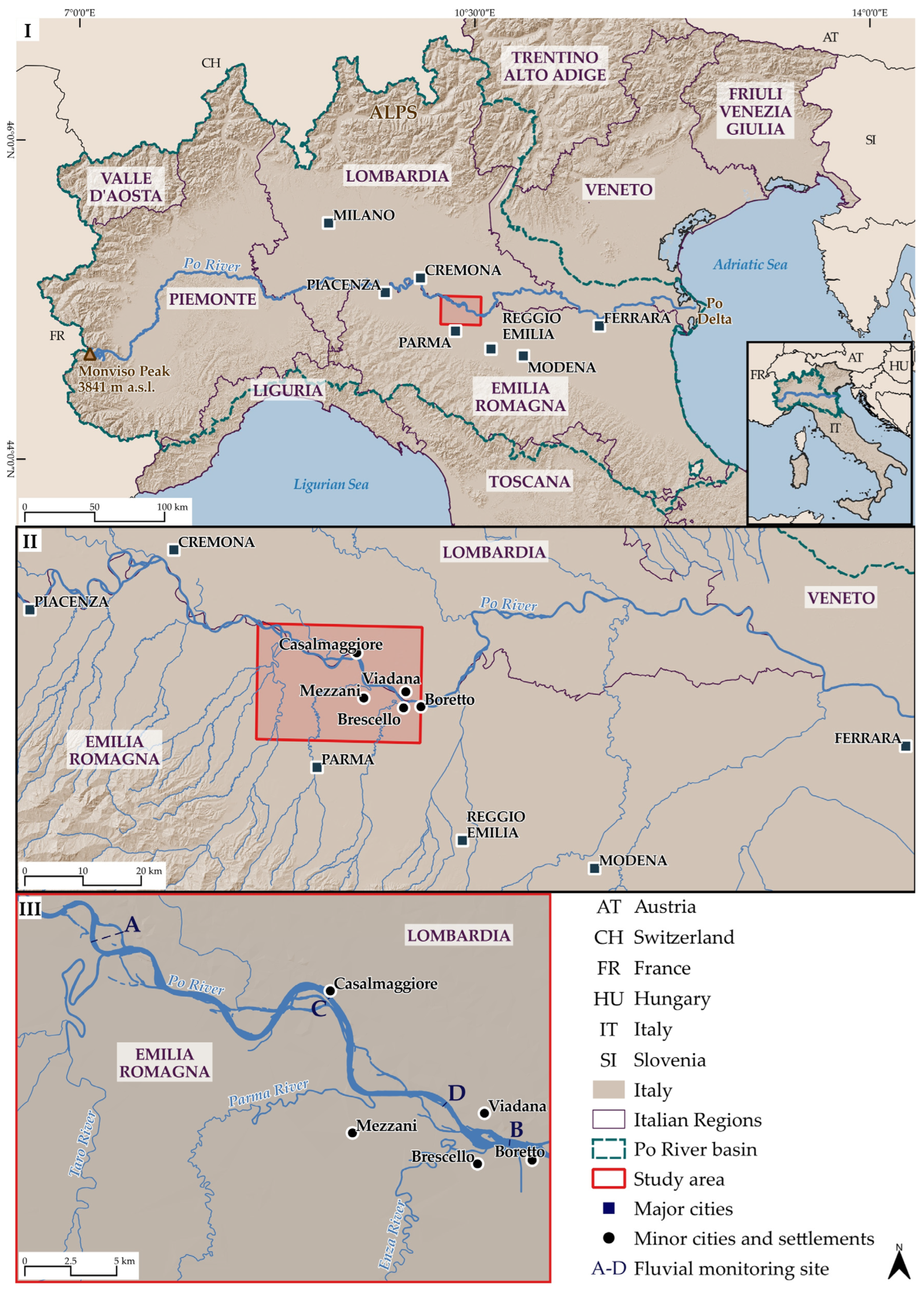
2.1. The Study Area
2.2. Historical–Political Framework of the Study Area
2.3. Constraints on the Po Riverine Area in the Parma Stretch
3. Materials and Methods
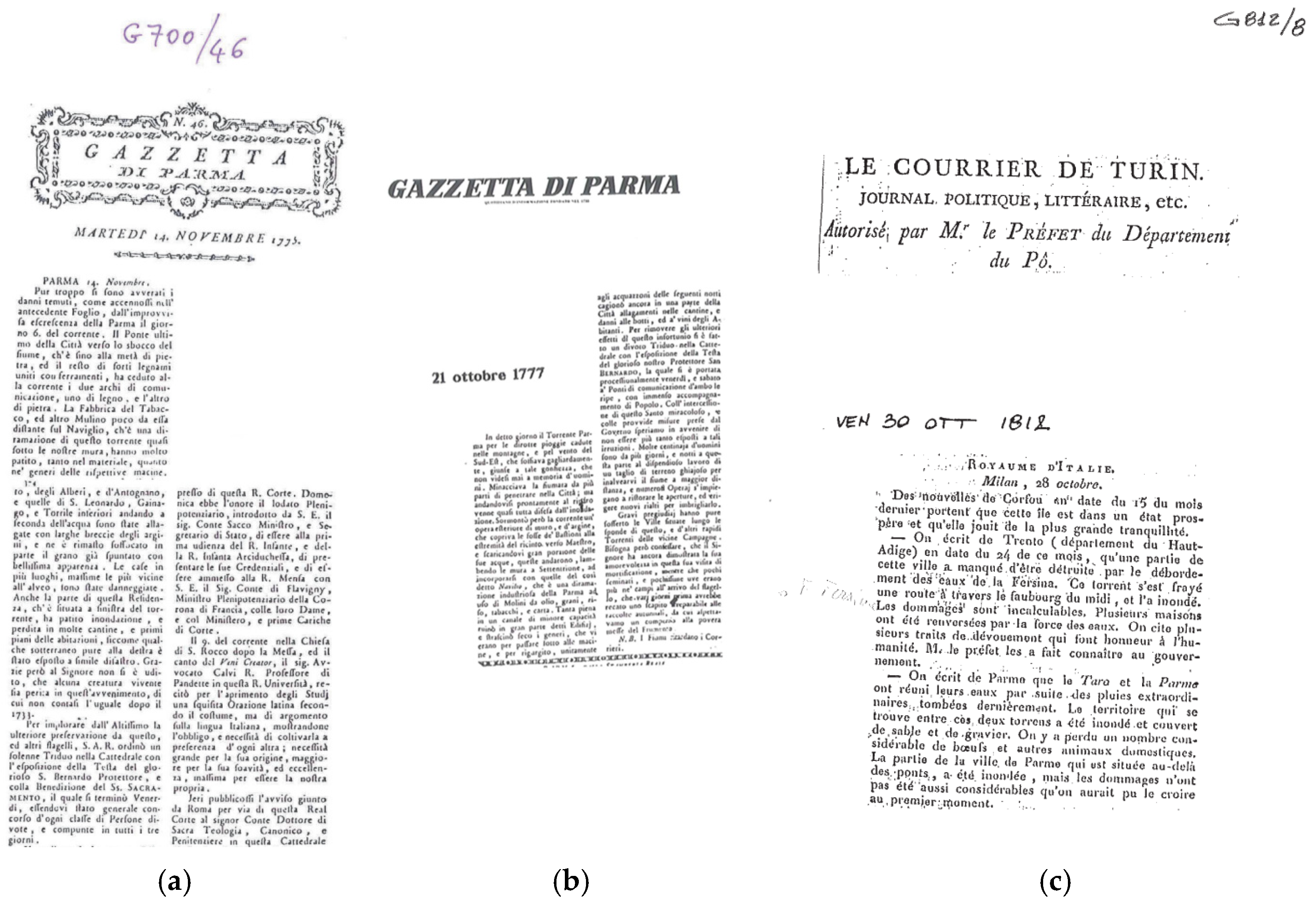
3.1. Multiresource Thematic Database
3.2. GIS Project

| Original Name | Description | Date | Source |
|---|---|---|---|
| P. Gozzi, Mappa dei territori rivieraschi del Po da Castelnuovo Bocca d’Adda a Brescello | Copy from the second half of the 18th century of a 1588 of map drawn by Cartographer and Engineer Smeraldi Smeraldo | 1588 | [80] |
| G. Cocconcelli, «Delineazione de’ Confini tanto controversi, quanto pacifici trà li Ducati di Parma, Piacenza e Guastalla e la Lombardia Austriaca» | Topographic map of the Po River, in the section between the Province of Pavia and Guastalla | 1788 | [80,81,82,83,84,85] |
| Topografia militare dei Ducati di Parma, Piacenza e Guastalla | Topographical maps of the Duchies of Parma, Piacenza and Guastalla, 1:28,800 scale | surveys 1820–1821 | [80] |
| Carta del corso del Po dal Ticino al Mare | Map of the Po River course from Ticino to the Sea also known as “Brioschi Collection” 1:15,000 scale | surveys 1821 updated in 1853 | [76] |
| Istituto Geografico Militare Italiano | Maps of National cartographic authority, 1:25,000 scale | 1881–1888 | [86] |
| CNR IRPI Archive | Maps of, 1:100,000 scale | 1920 | [47,86] |
| Po river basin images | Aerial photographs | 1953,1960,1973,1977, 1980, and 1990 | [77] |
| Technical Regional Italian Maps | Carta tecnica regionale (Regione Emilia-Romagna), scala 1:10,000 | 2000 | [79] |
| Emilia-Romagna regional aerial photographs | Aerial Photographs | 2011, 2019, and 2024 | [79] |
| Autorità di Bacino distrettuale del Fiume Po Map | Lidar images an DTM | 2005 | [87] |
| Po river satellite images | Satellite images (SAR 2) | 1992, 1996, and 2000 | [78] |
| Corine Land Cover | Land-Use Lombardy and Emilia-Romagna regions | 1853, 1976,1980, 1994, 1999, 2020, and 2021 | [79,88] |
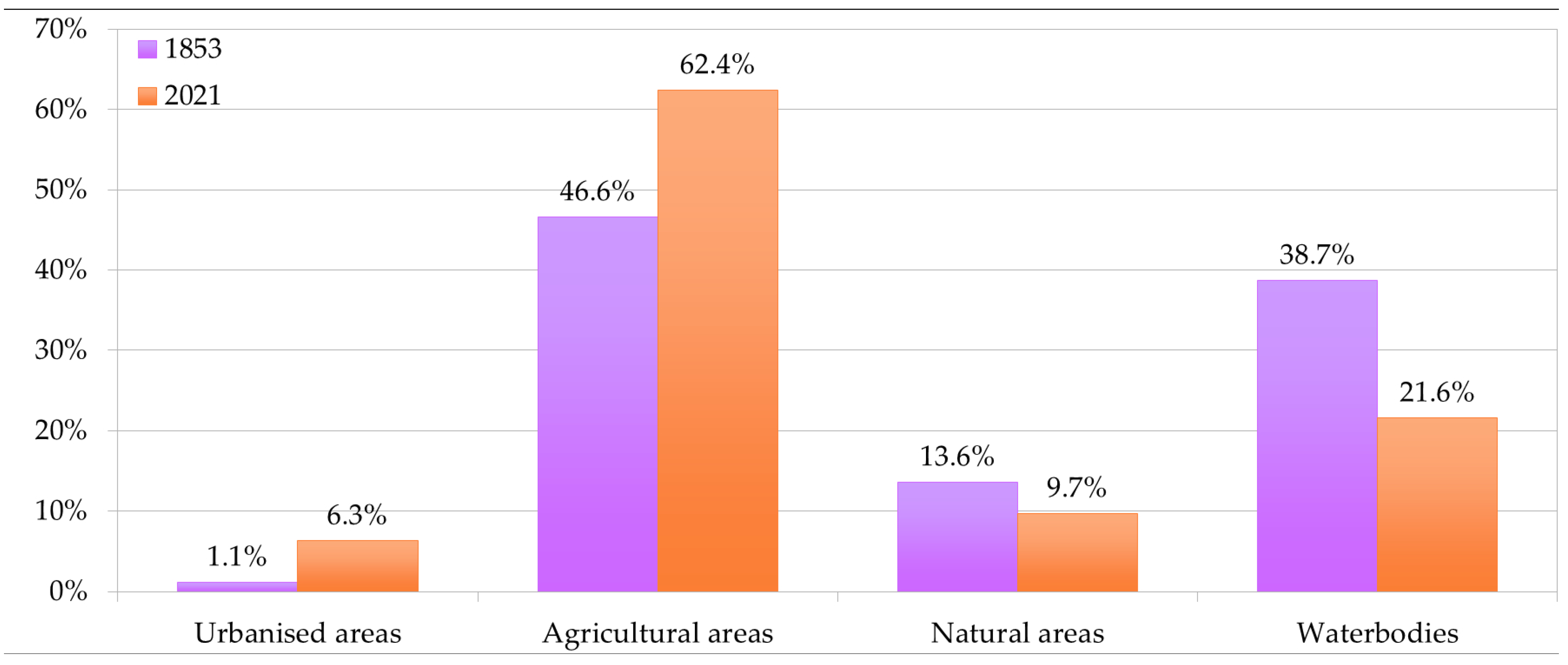
3.3. Land Use
3.4. Flood Events in the Po River and Tributary Hydraulic Network in the Province of Parma
4. Results
4.1. Database: Multithematic Spatial Interpretation and Knowledge Sharing
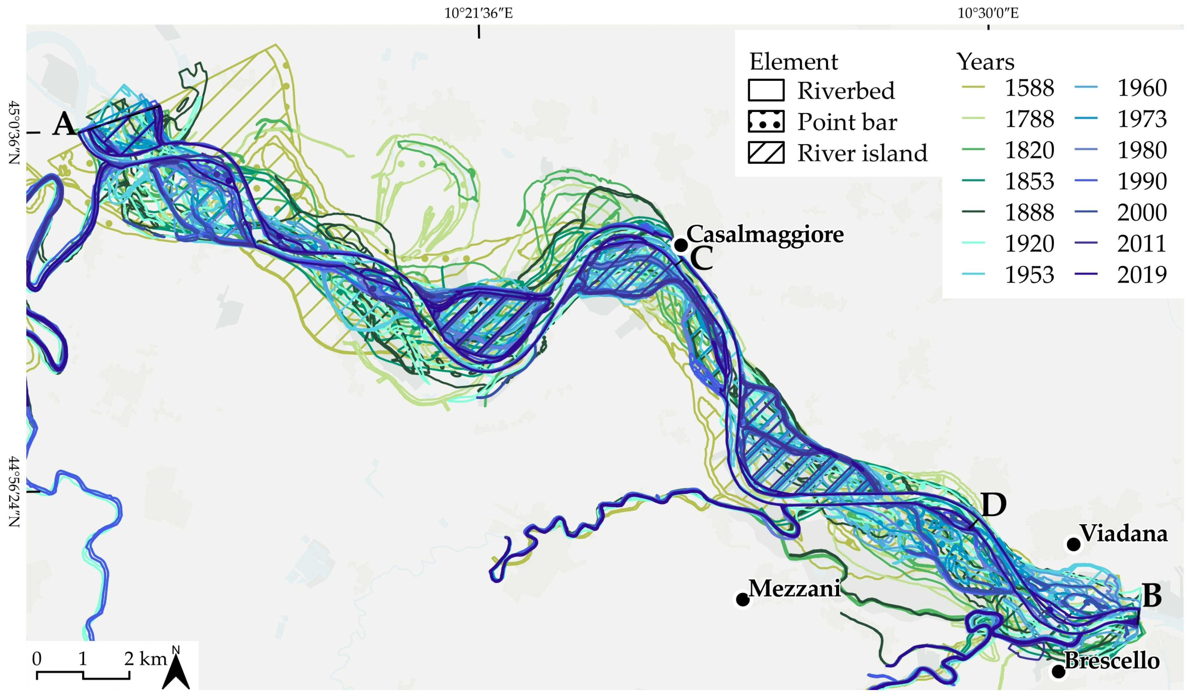
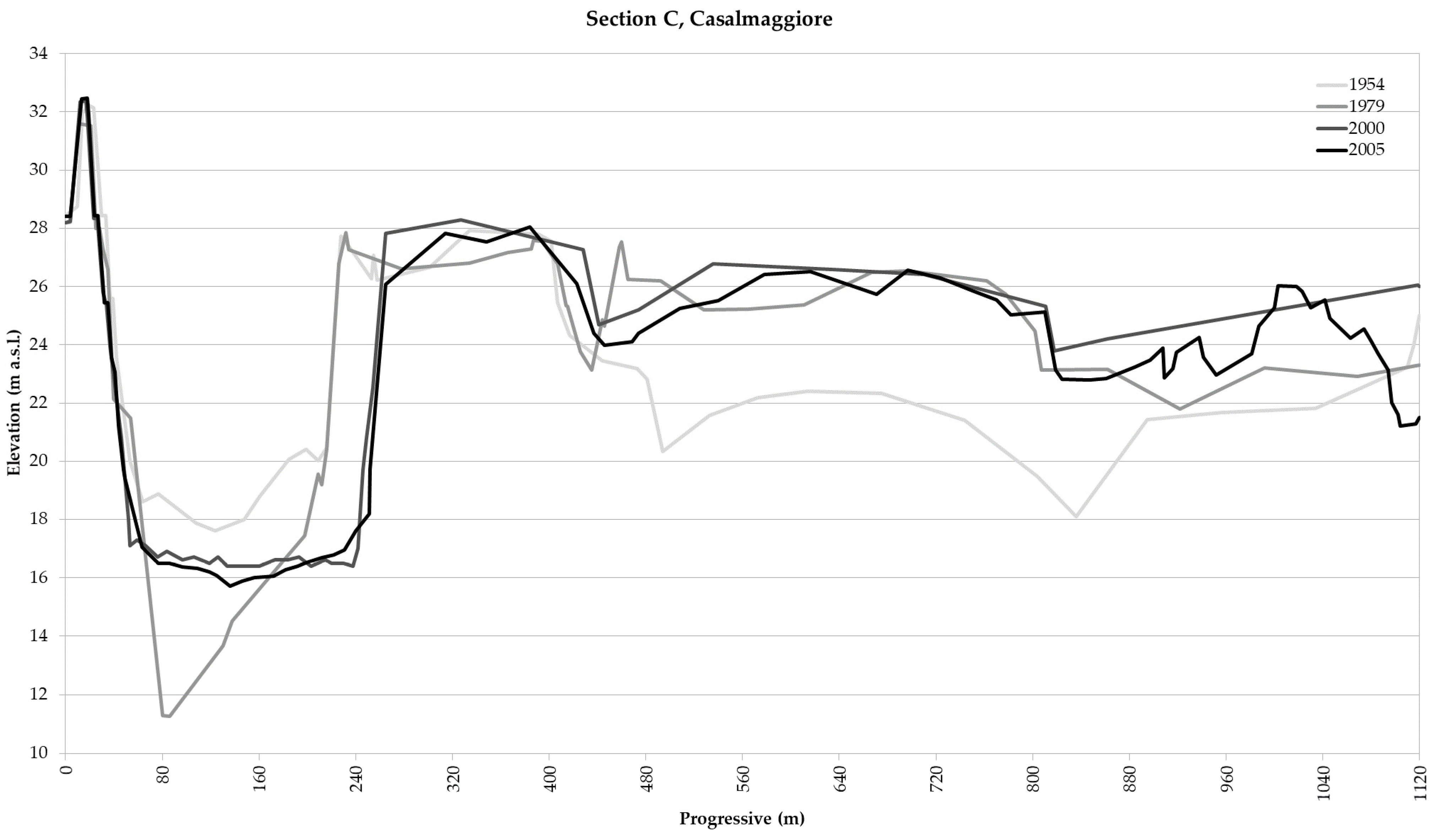
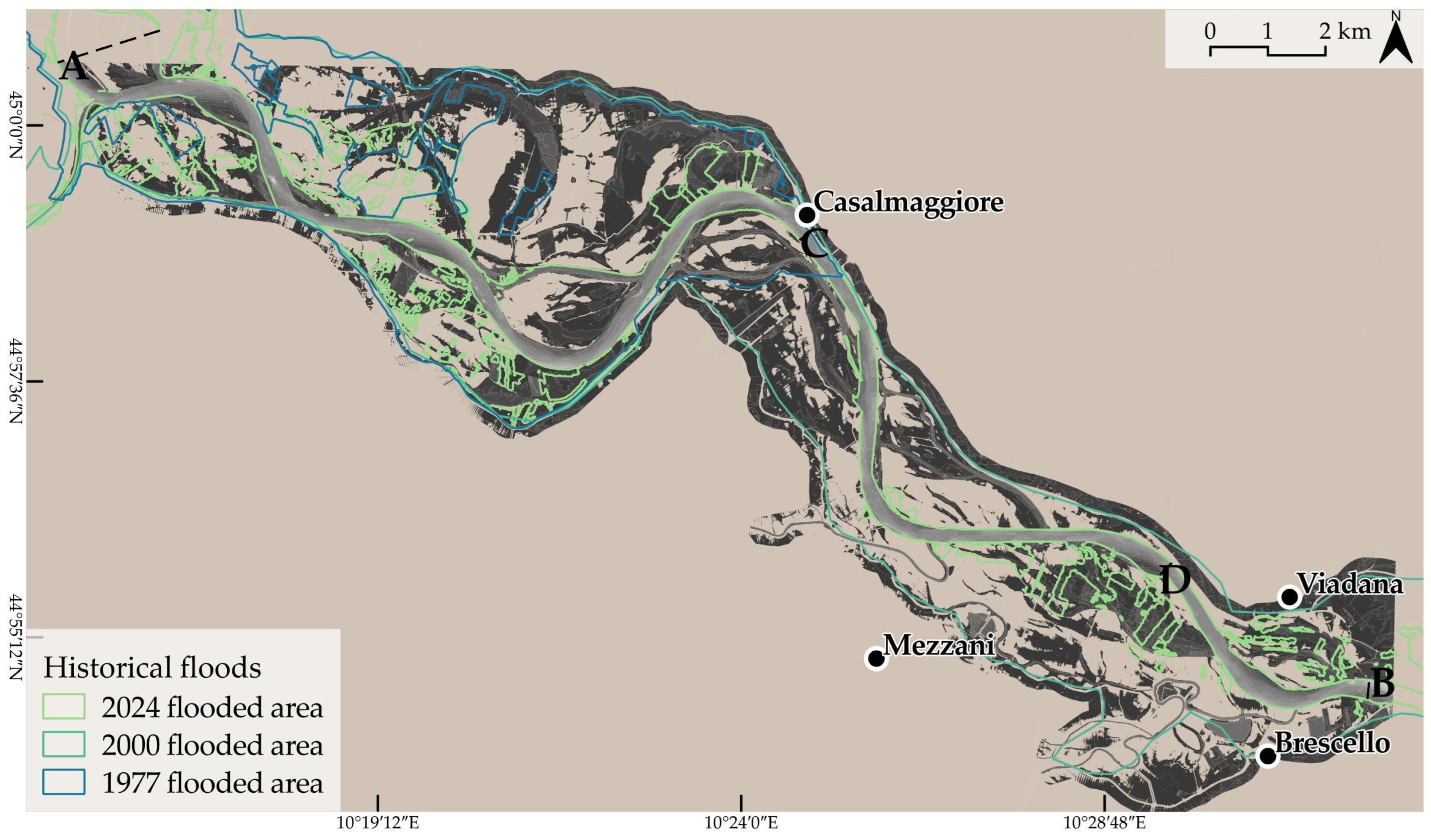
4.2. The Geomorphological Transformations of the Riverine Area
4.2.1. Fragility of the Embankment System Facing Relict Morphologies
4.2.2. Reduction in Riverine Areas
4.2.3. Migration of the Tributaries Confluences in the Po River
5. Discussion
6. Conclusions
Author Contributions
Funding
Institutional Review Board Statement
Informed Consent Statement
Data Availability Statement
Acknowledgments
Conflicts of Interest
References
- Vietz, G.J.; Sammonds, M.J.; Walsh, C.J.; Fletcher, T.D.; Rutherfurd, I.D.; Stewardson, M.J. Ecologically relevant geomorphic attributes of streams are impaired by even low levels of watershed effective imperviousness. Geomorph 2014, 206, 67–78. [Google Scholar] [CrossRef]
- Smiraglia, D.; Cavalli, A.; Giuliani, C.; Assennato, F. The Increasing Coastal Urbanization in the Mediterranean Environment: The State of the Art in Italy. Land 2023, 12, 1017. [Google Scholar] [CrossRef]
- Antrop, M. Changing patterns in the urbanized countryside of Western Europe. Landsc. Ecol. 2000, 15, 257–270. [Google Scholar] [CrossRef]
- Turconi, L.; Bono, B.; Faccini, F.; Luino, F. Anthropic Constraint Dynamics in European Western Mediterranean Floodplains Related to Floods Events. Remote Sens. 2023, 15, 4798. [Google Scholar] [CrossRef]
- Cutter, S.L.; Emrich, C.T.; Gall, M.; Reeves, R. Flash Flood Risk and the Paradox of Urban Development. Nat. Hazards Rev. 2018, 19, 05017005. [Google Scholar] [CrossRef]
- MacDonald, D.; Crabtree, J.R.; Wiesinger, G.; Dax, T.; Stamou, N.; Fleury, P.; Gutierrez Lazpita, J.; Gibon, A. Agricultural Abandonment in Mountain Areas of Europe: Environmental Consequences and Policy Response. J. Environ. Manag. 2000, 59, 47–69. [Google Scholar] [CrossRef]
- Luino, F.; Paliaga, G.; Roccati, A.; Sacchini, A.; Turconi, L.; Faccini, F. Anthropogenic changes in the alluvial plains of the Tyrrhenian Ligurian basins. Rend. Online Della Soc. Geol. Ital. 2019, 48, 10–16. [Google Scholar] [CrossRef]
- Strollo, A.; Smiraglia, D.; Bruno, R.; Assennato, F.; Congedo, L.; De Fioravante, P.; Giuliani, C.; Marinosci, I.; Riitano, N.; Munafò, M. Land Consumption in Italy. J. Maps 2020, 16, 113–123. [Google Scholar] [CrossRef]
- Mandarino, A.; Faccini, F.; Luino, F.; Bono, B.; Turconi, L. Integrated Approach for the Study of Urban Expansion and River Floods Aimed at Hydrogeomorphic Risk Reduction. Remote Sens. 2023, 15, 4158. [Google Scholar] [CrossRef]
- Bruno, L.; Piccin, A.; Sammartino, I.; Amorosi, A. Decoupled geomorphic and sedimentary response of Po River and its Alpine tributaries during the last glacial/post-glacial episode. Geomorphology 2018, 317, 184–198. [Google Scholar] [CrossRef]
- Bahmanpouri, F.; Barbetta, S.; Gualtieri, C.; Ianniruberto, M.; Filizola, N.; Termini, D.; Moramarco, T. Prediction of river discharges at confluences based on Entropy theory and surface-velocity measurements. J. Hydrol. 2022, 606, 127404. [Google Scholar] [CrossRef]
- Luino, F. Le inondazioni storiche del Fiume Po in particolare dal 1861 a oggi. In L’italia Dei Disastri: Dati E Riflessioni Sull’impatto Degli Eventi Naturali 1861–2013; Guidoboni, E., Valensise, G., Eds.; Bonomia University Press: Bologna, Italy, 2013; pp. 109–158. ISBN 978-88-7395-904-5. [Google Scholar]
- Sivapalan, M.; Savenije, H.H.G.; Blöschl, G. Socio-hydrology: A new science of people and water. Hydrol. Process. 2012, 26, 8, 1270–1276. [Google Scholar] [CrossRef]
- Barendrecht, M.H.; Viglione, A.; Bloeschl, G. A dynamic framework for flood risk. Water Secur. 2017, 1, 3–11. [Google Scholar] [CrossRef]
- Blöschl, G.; Hall, J.; Parajka, J.; Perdigão, R.A.P.; Merz, B.; Arheimer, B.; Aronica, G.T.; Bilibashi, A.; Bonacci, O.; Borga, M.; et al. Changing climate shifts timing of European floods. Science 2017, 357, 588–590. [Google Scholar] [CrossRef]
- Parrinello, G.; Bizzi, S.; Surian, N. The retreat of the delta: A geomorphological history of the Po river basin during the twentieth century. Water Hist. 2021, 13, 117–136. [Google Scholar] [CrossRef]
- ISTAT Italian Statistical Data. Available online: https://www.istat.it/storage/rapporto-annuale/2023/Rapporto-Annuale-2023.pdf (accessed on 10 January 2025).
- FONTES Project. Available online: https://fontes.univr.it/ (accessed on 27 May 2022).
- Vietz, G.J.; Walsh, C.J.; Fletcher, T.D. Urban hydrogeomorphology and the urban stream syndrome: Treating the symptoms and causes of geomorphic change. Prog. Phys. Geogr. Earth Environ. 2016, 40, 480–492. [Google Scholar] [CrossRef]
- Blöschl, G.; Kiss, A.; Viglione, A.; Barriendos, M.; Böhm, O.; Brazdil, R.; Coeur, D.; Demaree, G.; Llasat, M.C.; MacDonald, N.; et al. Current European flood-rich period exceptional compared with past 500 years. Nature 2020, 583, 560–566. [Google Scholar] [CrossRef] [PubMed]
- Yzaguirre, A.; Smit, M.; Warren, R. Newspaper archives + text mining = rich sources of historical geo-spatial data. IOP Conf. Ser. Earth Environ. Sci. 2016, 34, 12043. [Google Scholar] [CrossRef]
- Luino, F.; Barriendos, M.; Gizzi, F.T.; Glaser, R.; Gruetzner, C.; Palmieri, W.; Porfido, S.; Sangster, H.; Turconi, L. Historical Data for Natural Hazard Risk Mitigation and Land Use Planning. Land 2023, 12, 1777. [Google Scholar] [CrossRef]
- EM-DAT. The International Disaster Database. Available online: www.emdat.be (accessed on 28 June 2023).
- WMO. 2021. Available online: https://wmo.int/media/news/weather-related-disasters-increase-over-past-50-years-causing-more-damage-fewer-deaths (accessed on 28 June 2023).
- Barredo, J.I. Major Flood Disasters in Europe: 1950–2005. Nat. Hazards 2007, 42, 125–148. [Google Scholar] [CrossRef]
- Himmelsbach, I.; Glaser, R.; Schönbein, J.; Riemann, D.; Martin, B. Reconstruction of flood events based on documentary data and transnational flood risk analysis of the upper Rhine and its French and German tributaries since AD 1480. Hydrol. Earth Syst. Sci. 2015, 19, 4149–4164. [Google Scholar] [CrossRef]
- Brázdil, R.; Kundzewicz, Z.W.; Benito, G. Historical hydrology for studying flood risk in Europe. Hydrol. Sci. J. 2006, 51, 739–764. [Google Scholar] [CrossRef]
- Bürger, K.; Dostal, P.; Seidel, J.; Imbery, F.; Barriendos, M.; Mayer, H.; Glaser, R. Hydrometeorological reconstruction of the 1824 flood event in the Neckar River basin (southwest Germany). Hydrol. Sci. J. 2006, 51, 864–877. [Google Scholar] [CrossRef]
- Herget, J.; Meurs, H. Reconstructing peak discharges for historic flood levels in the city of Cologne, Germany. Glob. Planet. Chang. 2010, 70, 108–116. [Google Scholar] [CrossRef]
- Roggenkamp, T.; Herget, J. Reconstructing peak discharges of historic floods of the River Ahr, Germany. Erdkunde 2014, 68, 49–59. [Google Scholar] [CrossRef]
- Tavares, A.O.; Pato, R.L.; Magalhaes, M.C. Spatial and temporal landuse change and occupation over the last half century in a peri-urban area. Appl. Geogr. 2012, 34, 432–444. [Google Scholar] [CrossRef]
- Sangster, H.; Jones, C.; Macdonald, N. The co-evolution of historical source materials in the geophysical, hydrological and meteorological sciences: Learning from the past and moving forward. Prog. Phys. Geogr. 2018, 42, 61–82. [Google Scholar] [CrossRef]
- Grünthal, G. The history of historical earthquake research in Germany. Ann. Geophys. 2004, 42, 631–643. [Google Scholar] [CrossRef]
- Garnier, E.; Lahournat, F. Japanese stone monuments and disaster memory–Perspectives for DRR. Disaster Prev. Manag. 2022, 31, 1–12. [Google Scholar] [CrossRef]
- Marazzi, S. Atlante Orografico delle Alpi. SOIUSA, Pavone Canavese (TO), Priuli and Verlucca Editori, 2005. Available online: https://data.europa.eu/data/datasets/arlpa_to-12-03-01-d_2016-09-20-15-00?locale=fr (accessed on 19 November 2023).
- Gorgni, C.; Martinelli, G.; Sighinolfi, G.P. Isotopic evidence of paleowaters in the Po sedimentary basin (Northern Italy) Isotopic evidence of paleowaters in the Po sedimentary basin (Northern Italy). Geochem. J. 1982, 16, 2, 51–61. [Google Scholar] [CrossRef]
- Castiglioni, G.B.; Ajassa, R.; Baroni, C.; Biancotti, A.; Bondesan, A.; Bondesan, M.; Brancucci, G.; Castaldini, D.; Castellaccio, E.; Cavallin, A.; et al. Carta Geomorfologica della Pianura Padana. 1997. Maps at 1:250,000 Scale. Available online: https://www.researchgate.net/publication/263247790_Carta_Geomorfologica_della_Pianura_Padana_3_Fogli_alla_scala_1250000#fullTextFileContent (accessed on 4 October 2024).
- Ghielmi, M.; Minervini, M.; Nini, C.; Rogledi, S.; Rossi, M. Late Miocene-Middle Pleistocene sequences in the Po Plain—Northern Adriatic Sea (Italy): The stratigraphic record of modification phases affecting a complex foreland basin. Mar. Pet. Geol. 2013, 42, 50–81. [Google Scholar] [CrossRef]
- Ghielmi, M.; Minervini, M.; Nini, C.; Rogledi, S.; Rossi, M.; Vignolo, A. Sedimentary and tectonic evolution in the eastern Po-Plain and northern Adriatic Sea area from Messinian to Middle Pleistocene (Italy). Rend. Lincei 2010, 21 (Suppl. 1), 131–166. [Google Scholar] [CrossRef]
- Deschamps, P.; Durand, N.; Bard, E.; Hamelin, B.; Camoin, G.; Thomas, A.L.; Henderson, G.M.; Okuno, J.; Yokoyama, Y. Ice-sheet collapse and sea-level rise at the Bølling warming 14,600 years ago. Nature 2012, 483, 559–564. [Google Scholar] [CrossRef] [PubMed]
- Lambeck, K.; Rouby, H.; Purcell, A.; Sun, Y.; Sambridge, M. Sea level and global ice volumes from the Last Glacial Maximum to the Holocene. Proc. Natl. Acad. Sci. USA 2014, 111, 15296–15303. [Google Scholar] [CrossRef]
- Nones, M.; Guerrero, M.; Schippa, L.; Cavalieri, I. Remote sensing assessment of anthropogenic and climate variation effects on river channel morphology and vegetation: Impact of dry periods on a European piedmont river. Earth Surf. Process. Landf. 2024, 49, 1632–1652. [Google Scholar] [CrossRef]
- Tarpanelli, A.; Bonaccorsi, B.; Sinagra, M.; Domeneghetti, A.; Brocca, L.; Barbetta, S. Flooding in the Digital Twin Earth: The Case Study of the Enza River Levee Breach in De-cember 2017. Water 2023, 15, 1644. [Google Scholar] [CrossRef]
- Barbieri, S.; Martinelli, G. Hydrogeological Features of the Enza River Alluvial Fan (Province of Reggio Emilia). Mem. Descr. Carta Geol. d’It. 2007, 76, 17–38. [Google Scholar]
- Dazzi, S.; Aureli, F.; Vacondio, R.; Mignosa, P. Simulation of the December 2017 flood on the Enza River using a 2D SWE code coupled with a levee breach erosion model. In Proceedings of the 5th IAHR Europe Congress—New Challenges in Hydraulic Research and Engineering, Trento, Italy, 12–14 June 2018; Armanini, A., Nucci, E., Eds.; 5th IAHR Europe Congress Organizers: Trento, Italy, 2018. [Google Scholar]
- Clerici, A.; Perego, S.; Chelli, A.; Tellini, C. Morphological changes of the floodplain reach of the Taro River (Northern Italy) in the last two centuries. J. Hydrol. 2015, 527, 1106–1122. [Google Scholar] [CrossRef]
- CNR IRPI Institute for Research for Geo-Hydrological Prevention Archive. Available online: https://www.cnr.it/en/institute/066/research-institute-for-geo-hydrological-protection-irpi (accessed on 10 March 2025).
- Surian, N.; Rinaldi, M. Morphological response to river engineering and management in alluvial channels in Italy. Geomorphology 2003, 50, 307–326. [Google Scholar] [CrossRef]
- Campana, D.; Marchese, E.; Theule, J.; Comiti, F. Channel degradation and restoration of an Alpine river and related morphological changes. Geomorphology 2014, 221, 230–241. [Google Scholar] [CrossRef]
- Mandarino, A.; Brandolini, P.; Terrone, M.; Faccini, F. Effects of urbanization on river morphology in a Mediterranean coastal city (Genova, Italy). Prog. Phys. Geogr. Earth Environ. 2024, 48, 820–851. [Google Scholar] [CrossRef]
- Ma, C.; Qiu, D.; Mu, X.; Gao, P. Morphological Evolution Characteristics of River Cross-Sections in the Lower Weihe River and Their Response to Streamflow and Sediment Changes. Water 2022, 14, 3419. [Google Scholar] [CrossRef]
- Azzoni, R.S.; Senese, A.; Zerboni, A.; Maugeri, M.; Smiraglia, C.; Diolaiuti, G.A. Estimating ice albedo from fine debris cover quantified by a semi-automatic method: The case study of Forni Glacier, Italian Alps. Cryosphere 2016, 10, 665–679. [Google Scholar] [CrossRef]
- Nardi, F.; Biscarini, C.; Di Francesco, S.; Manciola, P.; Ubertini, L. Comparing a large-scale DEM-based floodplain delineation algorithm with standard flood maps: The Tiber river basin case study. Irrig. Drain. 2013, 62, 11–19. [Google Scholar] [CrossRef]
- Govi, M.; Maraga, F. Inundation on the Po Plain caused by levee breaches. G. Geol. Appl. 2005, 1, 167–176. [Google Scholar] [CrossRef]
- Scorpio, V.; Comiti, F. Channel changes during and after extreme floods in two catchments of the Northern Apennines (Italy). Geomorphology 2024, 463, 109355. [Google Scholar] [CrossRef]
- Bertola, S.; Fontana, F.; Visentin, D. Lithic raw material circulation and settlement dynamics in the Upper Palaeolithic of the Venetian Prealps (NE Italy). A key-role for palaeoclimatic and landscape changes across the LGM? In Palaeolithic Italy, Advanced Studies on Early Human Adaptations in the Apennine Peninsula; Borgia, V., Lemorini, C., Eds.; Sidestone Press: Leiden, The Netherlands, 2018; pp. 219–246. [Google Scholar]
- Caroni, E.; Maraga, F.; Turitto, O. Effetti del percorso fluviale arginato sul controllo dei deflussi di piena: Risultati di una modellazione applicata ad un caso di studio nella pia-nura padana. Il Quaternario (Ital. J. Quat. Sci.) 1994, 7, 415–424. [Google Scholar]
- Camici, S.; Barbetta, S.; Moramarco, T. Levee body vulnerability to seepage: The case study of the levee failure along the Foenna stream on 1 January 2006 (central Italy). J. Flood Risk Manag. 2017, 10, 314–325. [Google Scholar] [CrossRef]
- Orlandini, S.; Moretti, G.; Albertson, J.D. Evidence of an emerging levee failure mechanism causing disastrous floods in Italy. Water Resour. Res. 2015, 51, 7995–8011. [Google Scholar] [CrossRef]
- Ansari, A.H.; Mejia, A.; Cibin, R. Flood teleconnections from levees undermine disaster resilience. Npj Nat. Hazards 2024, 1, 2. [Google Scholar] [CrossRef]
- Goeury, C.; Bacchi, V.; Zaoui, F.; Bacchi, S.; Pavan, S.; El kadi Abderrezzak, K. Uncertainty Assessment of Flood Hazard Due to Levee Breaching. Water 2022, 14, 3815. [Google Scholar] [CrossRef]
- Özer, I.E.; van Damme, M.; Jonkman, S.N. Towards an International Levee Performance Database (ILPD) and Its Use for Macro-Scale Analysis of Levee Breaches and Failures. Water 2020, 12, 119. [Google Scholar] [CrossRef]
- Akhter, F.; Mazzoleni, M.; Brandimarte, L. Analysis of 220 Years of Floodplain Population Dynamics in the US at Different Spatial Scales. Water 2021, 13, 141. [Google Scholar] [CrossRef]
- FEMA (Federal Emergency Management Agency). Guidance for Flood Risk Analysis and Mapping, Flood Risk Assessments; FEMA: Washington, DC, USA, 2020. Available online: https://www.fema.gov/sites/default/files/documents/fema_flood-risk-assessment-guidance.pdf (accessed on 15 October 2023).
- Ferrari, A.; Dazzi, S.; Vacondio, R.; Mignosa, P. Enhancing the resilience to flooding induced by levee breaches in lowland areas: A methodology based on numerical model-ling. Nat. Hazards Earth Syst. Sci. 2020, 20, 59–72. [Google Scholar] [CrossRef]
- Masotti, L. Fonti geostoriche e processi territoriali: Riflessioni teorico-metodologiche e strumenti operative. In Geotema Supplement; Pàtron Eds.: Parma, Italy, 2021; pp. 29–42. [Google Scholar]
- Filipovic, A.; Troiano, W. Strategie e Programmazione della Conservazione e Trasmissibilità del Patrimonio Culturale; Edizioni Scientifiche Fidei Signa: Roma, Italy, 2013; p. 250. ISBN 978-88-909158-8-8. [Google Scholar]
- Mambriani, C. Un’Emergency List per definire le priorità degli interventi in ambito culturale di Fondazione Cariparma (2010–2012). In Fondazioni e beni Ecclesiastici di Interesse Culturale. Sfide, Esperienze, Strumenti; Dania, V., Gazzero, L., Eds.; il Mulino: Bologna, Italy, 2023; pp. 219–230. [Google Scholar]
- McEwen, L.; Garde-Hansen, J.; Holmes, A.; Jones, O.; Krause, F. Sustainable flood memories, lay knowledges and the development of community resilience to future flood risk. Trans. Inst. Br. Geogr. 2017, 42, 14–28. [Google Scholar] [CrossRef]
- Masotti, L.; Stocchi, F. Itinerari di Smeraldi. Rappresentazione e Governo del Territorio NELL’OPERA di un Cartografo Farnesiano (1580–1634); Università di Verona, Cierre Eds.: Sommacampagna, Italy, 2023. [Google Scholar]
- Pezzana, A. Continuazione Delle Memorie Degli Scrittori e Letterati Parmigiani; tomo VI, seguito della parte II; Parma, Italy, 1827; pp. 574–917–922. [Google Scholar]
- Scarabelli, L. Di Smeraldo Smeraldi Ingegnere Parmigiano; Parma, Italy, 1845. [Google Scholar]
- Ronchini, A. Smeraldo Smeraldi. In Atti e Memorie delle RR. Deputazioni di Storia Patria delle Province Modenesi e Parmensi, 6th ed.; Carlo Vincenzi Eds.: Modena, Italy, 1872; pp. 489–500. [Google Scholar]
- Ronchini, A. Smeraldo Smeraldi. In Periodico di Numismatica e Sfragistica per la Storia d’Italia; M.Ricci Eds.: Firenze, Italy, 1873; Volume 5, pp. 207–218. [Google Scholar]
- Monica, L.; Quintelli, C. Io Smeraldo Smeraldi Ingegnero et Perito della Congregatione dei Cavamenti: Territorio, Città, Offizio nel Ducato di Parma, 1582–1634; Grafiche STEP Eds.: Parma, Italy, 1980. [Google Scholar]
- AIPO Geoportal. Available online: http://geoportale.agenziapo.it/web/index.php/it/cartografia-storica (accessed on 18 February 2023).
- Archive Aerial Photograph CNR IRPI. Available online: https://www.fototeca.to.irpi.cnr.it/ (accessed on 22 May 2022).
- ESA. The European Space Agency Website. Available online: https://www.esa.int/ESA_Multimedia/Images (accessed on 23 December 2024).
- Geoportale Regione Emilia-Romagna. Available online: https://geoportale.regione.emilia-romagna.it/ (accessed on 12 December 2024).
- Historical Archive of Parma. Original Maps.
- Lasagni, R. Dizionario Biografico dei Parmigiani, 1st ed.; PPS Eds.: Parma, Italy, 1999; Volume 2. [Google Scholar]
- Dall’Acqua, M. Enciclopedia di Parma, dalle Origini ai Giorni Nostri, 1st ed.; Franco Maria Ricci Eds: Parma, Italy, 1988. [Google Scholar]
- Masotti, L. Along the River Po: Cartographic and Toponymic Heritage (XVI-XX century), Permanence, Transformation, Substitution and Oblivion of Geographical Names. In Proceedings of the 3° Simposio Scientifico Internazionale Organizzato dalla Divisione Ellenico-Romana del Gruppo di Esperti in Toponomastica delle Nazioni Unite in Collaborazione con l’Istituto Geografico Militare e con il Consiglio Regionale della Campania, Napoli, Italy, 22–24 September 2021; Cantile, A., Kerfoot, H., Eds.; IGM: Firenze, Italy, 2022. [Google Scholar]
- Togninelli, L. All’ombra della Corona; Farnese, A., Alessandro Farnese Eds.: Parma, Italy, 2012; p. 628. ISBN 10 8890396814. [Google Scholar]
- Miani Uluhogian, F. Due cartografi al servizio del principe: Smeraldo Smeraldi e i Farnese, Gian Pietro Sardi e i Borbone. In Persistenze Feudali e Autonomie Comunitative in Stati Padani Fra Cinque e Settecento; Tocci, G., Ed.; CLUEB: Bologna, Italy, 1988; pp. 133–149. [Google Scholar]
- IGM Istituto Geografico Militare. Available online: https://www.igmi.org/ (accessed on 15 October 2024).
- ADBPO Digital Terrain Model. Available online: https://www.adbpo.it/carta-del-po-e-dtm/ (accessed on 10 March 2024).
- Geoportale Regione Lombardia. Available online: https://www.geoportale.regione.lombardia.it/ (accessed on 8 December 2024).
- Castaldini, D.; Marchetti, M.; Norini, G.; Vandelli, V.; Zuluaga Vélez, M.C. Geomorphology of the central Po Plain, Northern Italy. J. Maps 2019, 15, 780–787. [Google Scholar] [CrossRef]
- Giusti, C. II Modello Digitale Del Terreno (DTM) Come Supporto Alla Cartografia Geomorfologica: L’esempio Della Pianura Modenese (Pianura Padana, Italia Settentrionale). Atti Del Convegno Nazionale: “Cultura Cartografica e Culture Del Territorio” (Sassari, 2000), Bollettino dell’Associazione Italiana di Cartografia, AIC, vol. 111–113, Brigati, Genova, 409–417. Available online: https://www.openstarts.units.it/server/api/core/bitstreams/73d5a93c-226f-4743-b53a-16b5fc2d0b9b/content (accessed on 12 October 2024).
- Wolman, M.G.; Miller, J.P. Magnitude and Frequency of Forces in Geomorphic Process. J. Geol. 1960, 68, 54–74. [Google Scholar] [CrossRef]
- Bertoldi, W.; Gurnell, A.M.; Welber, M. Wood recruitment and retention: The fate of eroded trees on a braided river explored using a combination of field and remotely-sensed data sources. Geomorphology 2013, 180–181, 146–155. [Google Scholar] [CrossRef]
- Bacchi, B.; Orlandini, S.; Pellegrini, M. Le Alluvioni del Po nel Secolo XIX: Alla Ricerca Delle Cause. Available online: https://www.idrologia.unimore.it/pizzileo/web-archive/un%20po%20di%20carte/capitolo-10.pdf (accessed on 3 December 2024).
- Historical Flood Events in Parma Area. Available online: https://www.bibliotecapersicetana.it/node/238 (accessed on 15 November 2024).
- Servizio Idrografico Centrale. La Piena del Po del Novembre 1951. In Giornale del Genio Civile; Istituto Poligrafico dello Stato Eds.: Roma, Italy, 1952; CNR IRPI Archive; Volume 1, pp. 3–10. [Google Scholar]
- Masoero, A.; Claps, P.; Asselman, N.E.M.; Mosselman, E.; Di Baldassarre, G. Reconstruc-tion and analysis of the Po River inundation of 1951. Hydrol. Process. 2012, 27, 1341–1348. [Google Scholar] [CrossRef]
- Govi, M.; Turitto, O. Casistica storica sui processi d’interazione delle correnti di piena del Po con arginature e con elementi morfotopografici del territorio adiacente. Ist. Lomb. Accad. Sci. E Lett. 2000, 5, 105–160. [Google Scholar]
- Idrotecnica Italiana. Atti Piena. L’Acqua n.4 del 2002) Atti della Giornata di Studio a Mezzo Secolo dalla Piena del Po del 1951. Parma, 16 Novembre 2001. Available online: https://www.idrotecnicaitaliana.it/wp-content/uploads/2020/04/AA.VV_.-AttiPienadelPo-LAcqua-n.-4-2002.pdf (accessed on 25 November 2024).
- Chelli, A.; Segadelli, S.; Ercolessi, G.; Luciani, P.; Carlini, M.; Clerici, A.; Paganini, P.; Perego, S.; Tellini, C. The Geomorphological Map of the Floodplain of the River Taro (Northern Apennines) as Tool for Flood Hazards Assessment. In Proceedings of the 88° Congresso della Società Geologica Italiana, Naples, Italy, 7–9 September 2016; Available online: https://hdl.handle.net/20.500.14083/6355 (accessed on 25 November 2024).
- Ministero Dei Lavori Pubblici; Ufficio Idrografico del Po; Reale Commissione Per Gli Studi Sul Regime Idraulico Del Fiume Po. Annali Idrologici; Provveditorato Generale dello Stato Eds: Roma, Italy, 1917. [Google Scholar]
- Ministero Dei Lavori Pubblici; Ufficio Idrografico del Po; Reale Commissione Per Gli Studi Sul Regime Idraulico Del Fiume Po. Annali Idrologici; Provveditorato Generale dello Stato Eds: Roma, Italy, 1926. [Google Scholar]
- Ministero Dei Lavori Pubblici; Ufficio Idrografico del Po; Reale Commissione Per Gli Studi Sul Regime Idraulico Del Fiume Po. Annali Idrologici; Provveditorato Generale dello Stato Eds: Roma, Italy, 1952. [Google Scholar]
- Ministero Dei Lavori Pubblici; Ufficio Idrografico del Po; Reale Commissione Per Gli Studi Sul Regime Idraulico Del Fiume Po. Annali Idrologici; Provveditorato Generale dello Stato Eds: Roma, Italy, 1977. [Google Scholar]
- Nigrelli, G.; Raschellà, M.; Meo, R. Un Database Relazionale Web-Based Sulle Rotte Nell’arginatura Maestra del Fiume Po. GEAM. Geoingegneria Ambientale e Mineraria, 2014, Anno LI, n 2, Agosto 2014, 49–54 Localizzazione Georeferenziata dei Punti delle Rotte. Available online: https://www.irpi.cnr.it/product-service/database-relazionale-web-based-sulle-rotte-nellarginatura-maestra-del-fiume-po/ (accessed on 2 December 2024).
- Mignosa, P. Le Rotte Nel Tratto Emiliano. Available online: https://www.idrologia.unimore.it/orlandini/web-archive/un%20po%20di%20carte/capitolo-7.pdf (accessed on 11 November 2024).
- Masotti, L. The confluences of the Parma and Enza tributaries in the Po River. Environmental transfor-mations and socio-territorial processes drawn from geoiconographic sources (XV-XIX centuries). In Raíces Profundas. Un Viaje por las Fuentes Geohistóricas Hasta la Ilustración; Camarero Bullón, C., Gómez Navarro, M., Luna San Eugenio, A., Eds.; UAM Ediciones-Ediciones Universidad Cantabria: Madrid, Spain, 2024; pp. 329–349. [Google Scholar]
- Camarero Bullón, C.; Gómez Navarro, M.; Luna San Eugenio, A. Raíces Profundas. Un Viaje por las Fuentes Geohistóricas Hasta la Ilustración, UAM Ediciones-Ediciones Universidad Cantabria; Santander: Madrid, Spain, 2024; pp. 491–505. ISBN 978-84-19024-77-0. UAM Ediciones-Ediciones Universidad Cantabria: Madrid, Spain. ISBN 978-84-8344-966-0. [Google Scholar]
- Brázdil, R.; Valášek, H. Use of historic data in studying damage due to natural disasters at the domain of Pernštejn in the period 1694–1718 and as a source of information for the study of meteorological and hydrological extremes. Meteorol. þasopis 2003, 6, 3–13. [Google Scholar]
- Wei, Z.; Han, Y.; Li, M.; Yang, K.; Yang, Y.; Luo, Y.; Ong, S.-H. A Small UAV Based Multi-Temporal Image Registration for Dynamic Agricultural Terrace Monitoring. Remote Sens. 2017, 9, 904. [Google Scholar] [CrossRef]
- Cucchiaro, S.; Paliaga, G.; Fallu, D.J.; Pears, B.R.; Walsh, K.; Zhao, P.; Van Oost, K.; Snape, L.; Lang, A.; Brown, A.G.; et al. Volume estimation of soil stored in agricultural terrace systems: A geomorphometric approach. Catena 2021, 207, 105687. [Google Scholar] [CrossRef]
- Godone, D.; Giordan, D.; Baldo, M. Rapid mapping application of vegetated terraces based on high resolution airborne lidar. Geomat. Nat. Hazards Risk 2018, 9, 970–985. [Google Scholar] [CrossRef]
- Camera, C.; Djuma, H.; Bruggeman, A.A.; Zoumides, C.; Eliades, M.; Charalambous, K.; Abate, D.; Faka, M. Quantifying the effectiveness of mountain terraces on soil erosion protection with sediment traps and dry-stone wall laser scans. Catena 2018, 171, 251–264. [Google Scholar] [CrossRef]
- Cucchiaro, S.; Fallu, D.J.; Zhang, H.; Walsh, K.; Van Oost, K.; Brown, A.G.; Tarolli, P. Multiplatform-SfM and TLS Data Fusion for Monitoring Agricultural Terraces in Complex Topographic and Landcover Conditions. Remote Sens. 2020, 12, 1946. [Google Scholar] [CrossRef]
- Pavelsky, T.M.; Durand, M.T.; Andreadis, K.M.; Beighley, R.E.; Paiva, R.C.D.; Allen, G.H.; Miller, Z.F. Assessing the potential global extent of SWOT river discharge observations. J. Hydrol. 2014, 519 Pt B, 1516–1525. [Google Scholar] [CrossRef]


| Historical and Institutional Context | Date |
|---|---|
| Duchy of Milan | 1395–1535 |
| Alternation between the Kingdom of France and the Papal States | 1500–1545 |
| Farnese Duchies of Parma and Piacenza | 1545–1731 |
| Interregnum with alternation between Spanish and Austrian rule | 1732–1748 |
| Bourbon Duchies of Parma, Piacenza, and Guastalla | 1748–1802 |
| French General Administration | 1802–1808 |
| French Empire | 1808–1814 |
| Duchies of Parma, Piacenza, and Guastalla under Maria Luigia of Austria | 1815–1847 |
| Parma States under the Bourbon-Parma Dynasty | 1848–1859 |
| Kingdom of Italy | 1861–1946 |
| Italian Republic | 1946–today |
| Hydrometric Level Monitoring Station | Elevation of Hydrometric Zero | 1917 Flood Level (m) | 1926 Flood Level (m) | 1951 Flood Level (m) | 1977 Flood Level (m) | 1994 Flood Level (m) | 2000 Flood Level (m) | 2024 Flood Level (m) |
|---|---|---|---|---|---|---|---|---|
| Piacenza | 42.16 | 9.00 | 9.63 | 10.25 | 7.62 | 9.98 | 10.50 | 6.14 |
| Cremona | 34.34 | 5.41 | 5.20 | 5.95 | 5.12 | 5.87 | 6.15 | 2.40 |
| Casalmaggiore | 23.49 | 6.54 | 6.37 | 7.64 | 6.64 | 7.58 | 8.01 | 4.96 |
| Boretto | 19.95 | 7.72 | N.A. | 8.59 | 7.65 | 8.43 | 9.06 | 5.70 |
| Year | Area (km2) | Overlapping (%) |
|---|---|---|
| 1588 | 24.1 | 42.1% |
| 1788 | 22.4 | 39.1% |
| 1820 | 21.5 | 37.4% |
| 1853 | 16.3 | 28.4% |
| 1888 | 18.7 | 32.6% |
| 1920 | 19.0 | 33.1% |
| 1953 | 21.1 | 36.8% |
| 1960 | 17.1 | 29.8% |
| 1973 | 20.2 | 35.3% |
| 1980 | 19.6 | 34.2% |
| 1990 | 10.6 | 18.5% |
| 2000 | 16.1 | 28.2% |
| 2011 | 12.5 | 21.9% |
| 2019 | 11.3 | 19.8% |
| Levee Breach Code | Year of Channel-Pattern Included in Levee Breach Point 5 m Buffer |
|---|---|
| 1801_034010_dx1 | 1801 |
| 1801_034010_dx2 | 1801 |
| 1810_019057_sx1 | 1810, 1821, 1853, 1888, 1920, 1960, 1973, 1980, 1990, 2000, 2011, 2020 |
| 1839_034010_dx1 | 1839 |
| 1855_034010_dx1 | 1855 |
| 1855_034010_dx2 | 1855 |
| 1857_034021_dx1 | 1857 |
| 1857_034021_dx2 | 1857 |
| 1857_035006_dx1 | 1857 |
| 1868_034010_dx1 | 1868, 1888, 1920 |
| 1868_034010_dx2 | 1868, 1888, 1920 |
| 1868_034021_dx1 | 1868 |
| 1868_034021_dx2 | 1868 |
| 1951_034010_dx1 | 1951 |
| 1951_034021_dx1 | 1951 |
| 1982_019052_sx1 | 1588, 1821, 1953, 1982 |
| 1982_019108_sx1 | 1588, 1821, 1888, 1982 |
| 1982_019108_sx2 | 1588, 1821, 1982 |
| 1982_019108_sx3 | 1588, 1982 |
| 1994_019052_sx1 | 1788, 1994 |
| 1994_019052_sx2 | 1788, 1994 |
| 1994_019052_sx3 | 1588, 1853, 1994 |
| 1994_019052_sx4 | 1588, 1821, 1994 |
| 1994_019108_sx1 | 1588, 1821, 1994 |
| 1994_034010_dx1 | 1994 |
| 1994_034021_dx1 | 1821, 1994 |
| 1994_034021_dx2 | 1980, 1994 |
| 1994_034021_dx3 | 1588, 1994 |
| 1994_034021_dx4 | 1588, 1994 |
| 1994_034021_dx5 | 1994 |
| 2000_019061_sx1 | 1588, 2000 |
| 2000_019108_sx1 | 1588, 1788, 2000 |
| 2000_019108_sx2 | 1588, 2000 |
| Year | Riverbed Width (km) | |||
|---|---|---|---|---|
| A | B | C | D | |
| 1588 | 5.5 | 0.9 | 1.3 | 1.2 |
| 1788 | 1.9 | 1.2 | 1.1 | 2.1 |
| 1821 | 1.7 | 0.6 | 1.0 | 2.1 |
| 1853 | 1.3 | 0.7 | 0.5 | 0.8 |
| 1888 | 2.7 | 0.9 | 0.5 | 1.3 |
| 1920 | 2.7 | 1.0 | 0.8 | 1.1 |
| 1953 | 1.4 | 0.4 | 1.1 | 1.2 |
| 1960 | 1.5 | 0.7 | 1.5 | 1.1 |
| 1973 | 1.6 | 0.4 | 1.4 | 1.3 |
| 1980 | 1.6 | 0.4 | 1.3 | 1.4 |
| 1990 | 1.7 | 0.2 | 1.4 | 1.5 |
| 2000 | 1.8 | 0.4 | 1.0 | 1.5 |
| 2011 | 1.8 | 0.4 | 1.2 | 1.3 |
| 2019 | 1.9 | 0.3 | 1.3 | 1.2 |
| Year | Area (km2) | Overlap with Historical Morphology (%) |
|---|---|---|
| 1977 | 40.4 | 61.3% |
| 2000 | 62.4 | 43.7% |
| 2024 | 21.3 | 54.4% |
Disclaimer/Publisher’s Note: The statements, opinions and data contained in all publications are solely those of the individual author(s) and contributor(s) and not of MDPI and/or the editor(s). MDPI and/or the editor(s) disclaim responsibility for any injury to people or property resulting from any ideas, methods, instructions or products referred to in the content. |
© 2025 by the authors. Licensee MDPI, Basel, Switzerland. This article is an open access article distributed under the terms and conditions of the Creative Commons Attribution (CC BY) license (https://creativecommons.org/licenses/by/4.0/).
Share and Cite
Turconi, L.; Bono, B.; Mambriani, C.; Masotti, L.; Stocchi, F.; Luino, F. Natural and Anthropic Constraints on Historical Morphological Dynamics in the Middle Stretch of the Po River (Northern Italy). Sustainability 2025, 17, 6608. https://doi.org/10.3390/su17146608
Turconi L, Bono B, Mambriani C, Masotti L, Stocchi F, Luino F. Natural and Anthropic Constraints on Historical Morphological Dynamics in the Middle Stretch of the Po River (Northern Italy). Sustainability. 2025; 17(14):6608. https://doi.org/10.3390/su17146608
Chicago/Turabian StyleTurconi, Laura, Barbara Bono, Carlo Mambriani, Lucia Masotti, Fabio Stocchi, and Fabio Luino. 2025. "Natural and Anthropic Constraints on Historical Morphological Dynamics in the Middle Stretch of the Po River (Northern Italy)" Sustainability 17, no. 14: 6608. https://doi.org/10.3390/su17146608
APA StyleTurconi, L., Bono, B., Mambriani, C., Masotti, L., Stocchi, F., & Luino, F. (2025). Natural and Anthropic Constraints on Historical Morphological Dynamics in the Middle Stretch of the Po River (Northern Italy). Sustainability, 17(14), 6608. https://doi.org/10.3390/su17146608