1. Introduction
Rural landscape transformation has emerged as a critical topic in landscape studies, geography, and territorial planning, particularly in Mediterranean and European contexts where the interaction between historical rural structures and contemporary urban expansion is most evident. Rapid urbanization, socio-economic transitions, and land commodification increasingly compromise the integrity of cultural, ecological, and historical systems. A growing body of international literature has examined rural–urban transitions in emblematic cases such as the Spanish huertas, the peri-urban vineyards of Southern France, and the insular settlements of Greece, highlighting recurrent issues including land fragmentation, the loss of agricultural identity, and tensions surrounding adaptive reuse and heritage conservation strategies.
This paper contributes to the broader debate by investigating the case of Bagheria, a medium-sized town on the northern coast of Sicily, whose 17th–18th-century Baroque villas—originally built as aristocratic leisure estates integrated within productive agricultural lands—are now engulfed by unregulated and speculative urban growth. This transformation not only undermines the functional and symbolic continuity of the landscape but also endangers the cultural ecosystem services and spatial legibility of rural heritage. Through a GIS-based, diachronic spatial analysis covering the period from 1850 to 2018, this study documents changes in land use, spatial fragmentation, and urban encroachment on a system of 33 historical villas, offering a geospatially grounded framework for interpreting rural heritage loss and identifying mitigation strategies.
The relationship between urban expansion and historical rural architecture in Mediterranean regions reflects the intricate interplay between cultural heritage, landscape identity, and long-term spatial transformation processes. These dynamics often lead to the fragmentation of traditional agricultural systems and the erosion of rural infrastructures and heritage elements [
1,
2]. Bagheria offers a paradigmatic case study of such phenomena. Developed during the late Baroque period as both a seasonal retreat and an agro-productive center for Palermo nobility, the town is especially renowned for its extraordinary density of aristocratic villas. These buildings were embedded within a highly structured agrarian landscape characterized by orchards, vineyards, terraced gardens, and olive groves, functioning not only as residences but also as centers of agricultural and artisanal production [
3].
Constructed predominantly with the distinctive
Aspra limestone extracted from nearby coastal
pirriere, the villas of Bagheria possess a stylistic and material coherence that links them indelibly to their geographic and cultural context (
Figure 1). This use of local materials shaped not only their architectural identity but also established a durable connection between built heritage and the geomorphological and craft traditions of the territory [
4]. Initially immersed in extensive agricultural estates, the villas were surrounded by vineyards that, in the early 20th century, were progressively replaced by citrus orchards—a shift indicative of evolving agro-economic models adapted to the region’s fertile alluvial soils and temperate Mediterranean microclimate [
5].
Despite the cultural value of these landscape systems, the absence of an integrated heritage policy, coupled with weak enforcement of planning regulations, has led to their progressive disconnection from their rural matrix. This paper addresses three interrelated research questions: (i) How has the spatial configuration of Bagheria’s villa system evolved over the last 150 years? (ii) To what extent have urban expansion dynamics altered the visibility, accessibility, and landscape coherence of these heritage sites? (iii) What adaptive reuse strategies can reconcile cultural heritage preservation with sustainable urban development?
By addressing these questions, the study aims to contribute to the ongoing scholarly discourse on cultural landscape protection, historic urban–rural interfaces, and smart heritage strategies, while offering a replicable methodology for other Mediterranean contexts undergoing similar transformations.
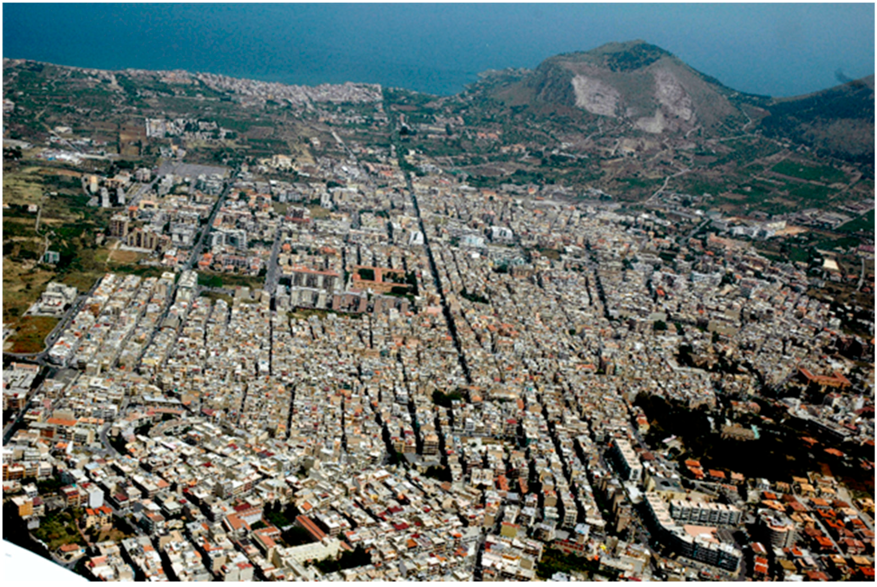
Aerial imagery of Bagheria (Sicily) reveals a densely urbanized fabric progressively expanding into former agricultural and peri-urban zones. These images highlight a marked spatial disconnection between the historical Baroque villas—now enclosed within a compact and irregular city grid—and the original rural matrix once composed of vineyards, olive groves, and citrus orchards. In the background, the Aspra coastline and the historic limestone quarries (pirriere) remain visible, underscoring the geological context from which the villas’ distinctive construction stone was sourced.
The transformation of the agrarian landscape from mixed cropping systems to citrus monoculture catalyzed the emergence of a sophisticated agro-industrial structure. This system comprised terraced gardens (
giardini), dry-stone retaining walls, paved access lanes, irrigation cisterns, and citrus-processing warehouses (
magazzini), all of which were functionally and architecturally integrated to support the production, storage, and primary processing of agricultural products [
6]. The development of the citrus canning industry in the early 20th century further reinforced the multifunctional role of this rural architecture, connecting Bagheria to broader economic and logistical circuits at regional and transnational scales.
These evolutions resonate with contemporary debates on the recovery, redesign, and valorization of historical agricultural and forestry buildings, particularly in light of current imperatives surrounding multifunctionality, adaptive reuse, and sustainability-oriented territorial governance [
7,
8,
9]. In this context, the built heritage of Bagheria—including storage structures and villa annexes repurposed for agro-processing—provides a compelling demonstration of how rural architecture can evolve over time while retaining cultural and functional coherence [
10].
However, starting in the 1950s, Bagheria experienced a phase of intense and largely unregulated urban expansion, propelled by rapid demographic growth and speculative real estate activity. This expansion unfolded in the absence of robust planning instruments or effective heritage protection mechanisms, resulting in the fragmentation of the historical agro-urban continuum. Many villas were engulfed by anonymous, high-density residential developments, often stripped of their gardens, sightlines, and symbolic relationships with the surrounding landscape—compromising their conservation, spatial identity, and territorial legibility [
11,
12].
In response to these dynamics, the present study adopts a multi-disciplinary methodology aimed at reconstructing the morphological and territorial evolution of Bagheria over a 166-year period (1852–2018). This approach integrates a variety of historical cartographic sources—such as Bourbon-era land registers and maps from the Istituto Geografico Militare [
13]—with multitemporal aerial imagery and satellite datasets (including GAI, Copernicus, and Landsat) to perform GIS-based spatial analysis of land use change, urban encroachment, and landscape fragmentation. Complementing this geospatial analysis, on-site architectural surveys, 3D photogrammetry, and typological documentation were conducted on a corpus of 33 Baroque villas to assess their current conservation status and spatial dislocation.
This methodological framework is aligned with state-of-the-art survey and representation techniques used in landscape architecture, forestry planning, and rural spatial analysis. It enables a diachronic, evidence-based interpretation of spatial transformations while providing data-driven guidance for sustainable and heritage-sensitive planning strategies [
14,
15]. The analysis aims to assess the level of vulnerability of rural architectural heritage, propose adaptive reuse models, and identify integrated regeneration pathways based on cultural continuity, ecological resilience, and infrastructure retrofitting.
Proposed interventions seek to enhance both the natural and anthropogenic components of the landscape through synergistic strategies that link architectural restoration to agro-industrial revitalization, environmental stewardship, and the creation of multifunctional rural infrastructure. These actions support broader territorial goals, including the reinforcement of place-based identity, the conservation of ecological corridors, and the reactivation of historic rural systems in ways that are compatible with contemporary land use and productive paradigms [
2,
6].
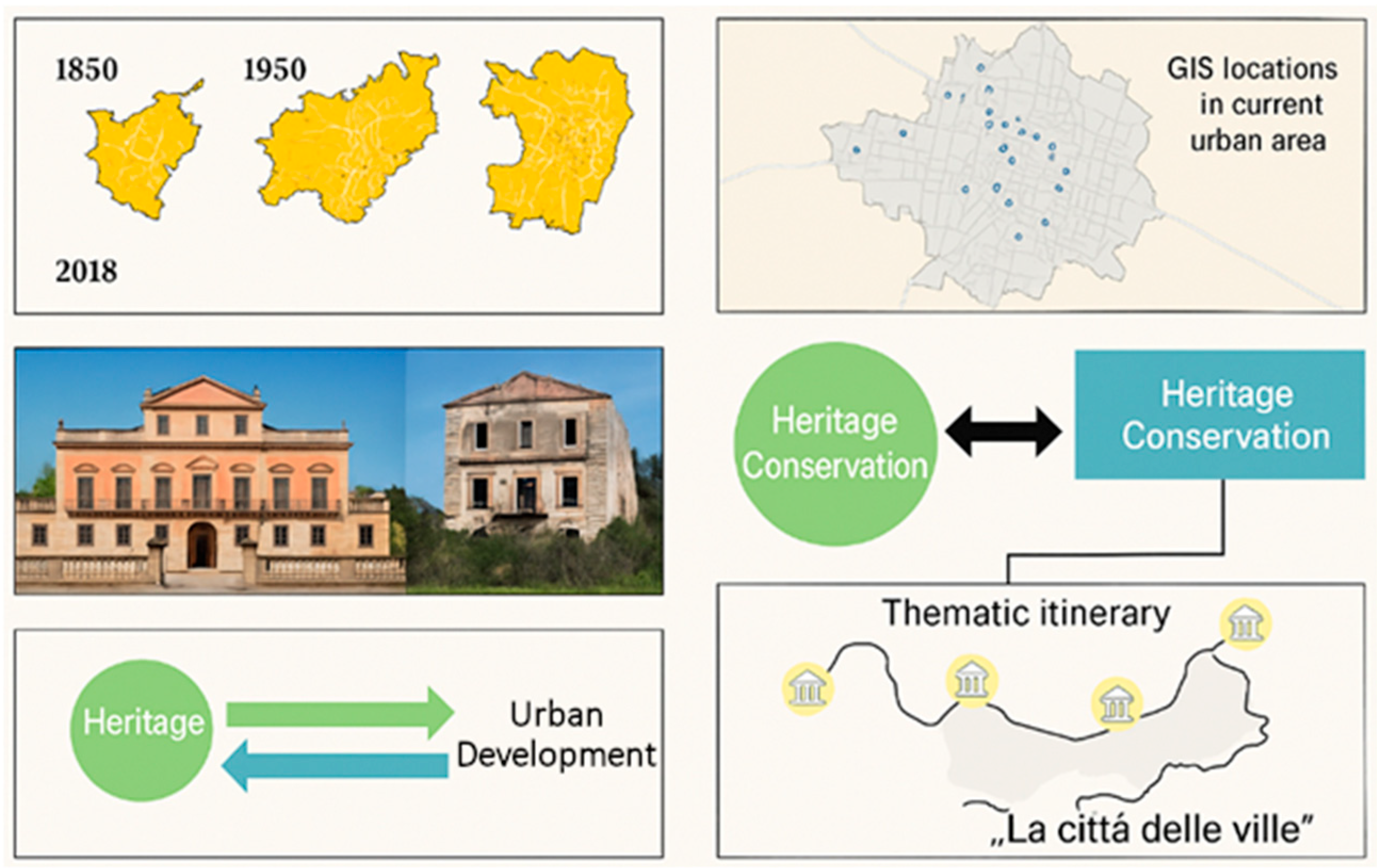
Ultimately, Bagheria emerges as a compelling case study and open-air laboratory for advancing knowledge and practice in agricultural and forestry systems planning, rural architecture, and landscape regeneration. By embedding the recovery of historic rural constructions within a wider territorial strategy, this study underscores the transformative potential of rural heritage in contributing to spatial justice, regional resilience, and the design of sustainable socio-ecological systems (
Figure 2).
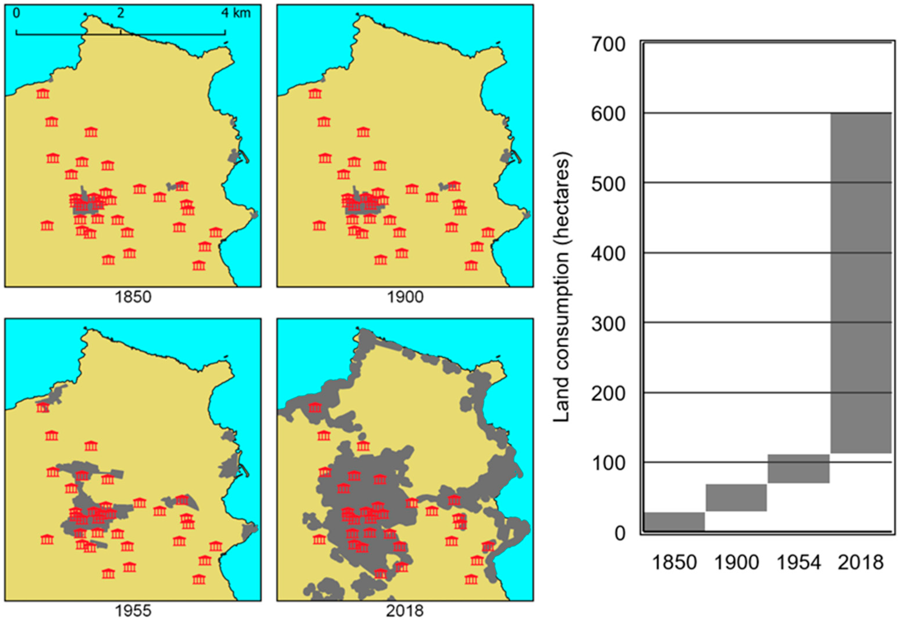
Figure 2 illustrates the diachronic urban expansion of Bagheria between 1850 and 2018 and its spatial impact on the preservation and legibility of the town’s Baroque villas. The figure integrates multiple thematic layers—including historical mapping, geolocated villa datasets, and comparative conservation assessments—to visualize the progressive fragmentation of the historical rural matrix and the increasing disconnection between heritage sites and their landscape context. It also introduces the conceptual proposal of a sustainable cultural itinerary titled,
“La città delle ville”, designed to reconnect these architectural landmarks through interpretive routes, visual corridors, and heritage-led planning instruments.
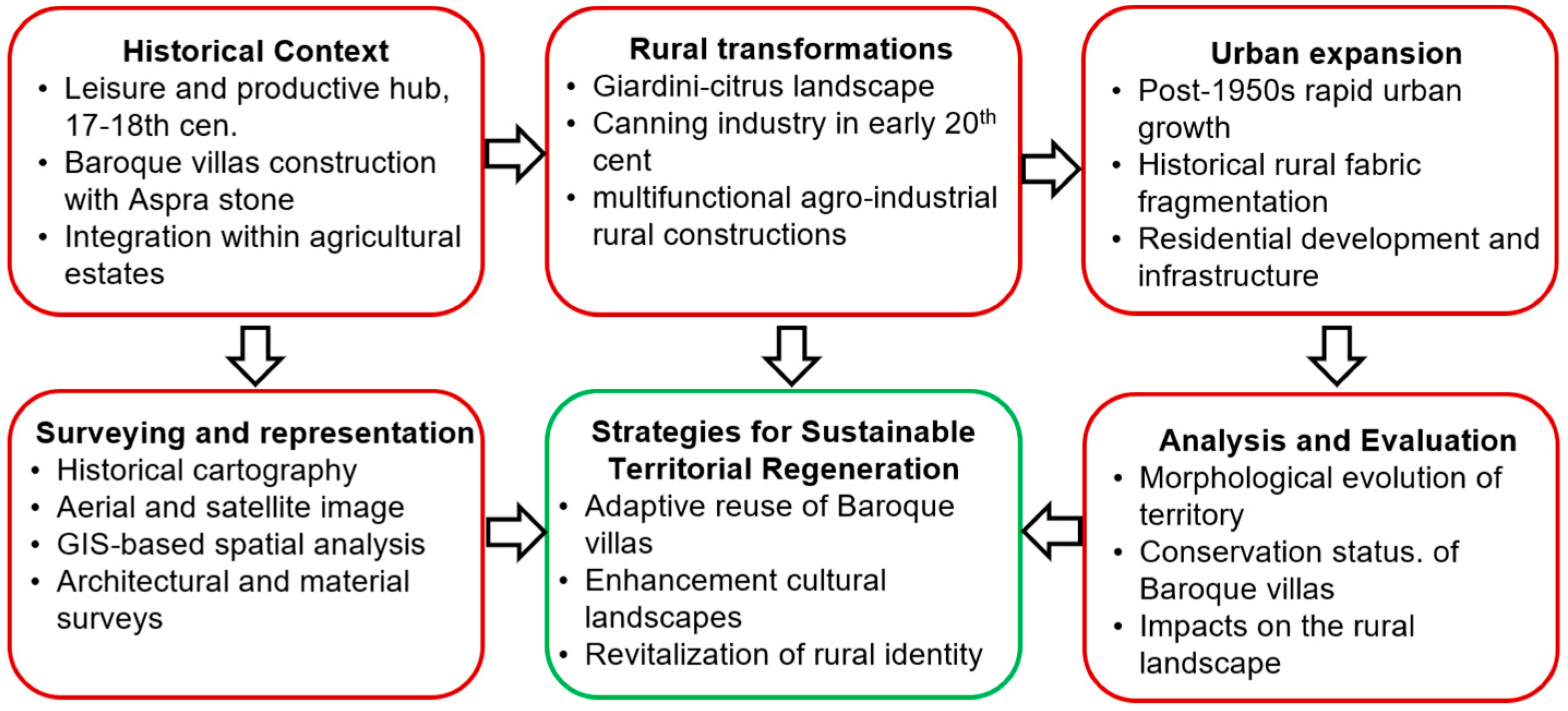
Figure 3 presents a schematic overview of the integrated methodological framework adopted to investigate the territorial and architectural transformation of Bagheria from 1852 to 2018. The diagram establishes a multi-scalar and interdisciplinary workflow that links historical processes—such as rural landscape restructuring and post-war urban sprawl—to a suite of advanced surveying and representation techniques, including historical cartography, aerial and satellite remote sensing, GIS-based spatial analysis, and on-site architectural documentation. The analytical phases encompass morphological assessments of the villa system, landscape vulnerability mapping, and the evaluation of spatial integration within the evolving urban fabric.
The outputs of this framework are oriented toward the design of sustainable territorial regeneration strategies. These include the adaptive reuse of Baroque villas, the rehabilitation of degraded cultural landscapes, and the reactivation of rural heritage systems as drivers of ecological continuity and place-based identity. In this way, the methodology not only documents the spatial dynamics of transformation but also supports actionable planning tools for the preservation and revitalization of Mediterranean rural heritage.
2. Materials and Methods
This study adopts a diachronic, multi-source methodological approach to investigate the spatial transformation of Bagheria (Sicily) and its effects on the historic system of 17th–18th-century Baroque villas. The methodology integrates both quantitative and qualitative techniques—namely GIS-based spatial analysis, historical cartography, and architectural fieldwork—consistent with interdisciplinary practices in landscape archeology, historical geography, and territorial planning [
1,
2,
9]. The approach is articulated across four key methodological components.
2.1. Historical Cartographic Analysis
A diachronic series of cartographic and remote sensing sources was collected and processed using QGIS (version 3.32) in order to reconstruct the historical evolution of the built environment in Bagheria. The base layers include the 1852 Bourbon map titled,
Carta Topografica della Regione di Palermo Levata dal Reale Officio Topografico di Napoli—Foglio 8, which covers the territories of Villabate, Bagheria, Altavilla Milicia, Misilmeri, Casteldaccia, Santa Flavia, and Ficarazzi. This was integrated with the municipal planimetry from 1900, aerial photographs from 1954, 1968 and 1992 (
Table 1) provided by the Italian Army’s Geographic Supporting Office (IGMI), and high-resolution satellite imagery from 2018 obtained from the Copernicus Sentinel-2 mission [
16,
17].
All datasets were georeferenced through the application of affine transformations using ground control points, and subsequently digitized and vectorized to allow for consistent spatial overlay. This process enabled the identification and temporal mapping of the built environment, facilitating the quantification of urban growth and land use change. Successive spatial overlays revealed patterns of land consumption, urban sprawl, and fragmentation of agricultural parcels, particularly in areas surrounding the documented Baroque villas [
12].
The analysis specifically investigated the spatial disconnection between the historical rural matrix and the expanding urban fabric, with emphasis on buffer zone encroachments and the progressive marginalization of heritage sites. These procedures align with advanced practices in the spatiotemporal modeling of peri-urbanization and rural landscape transformation, and reflect established methodologies in landscape planning, heritage vulnerability mapping, and geohistorical analysis [
18,
19].
2.2. GIS-Based Spatial Evaluation
Building upon the vectorized cartographic layers, a set of spatial metrics was calculated to quantify urban growth dynamics and assess the vulnerability of cultural heritage within the evolving landscape matrix. Specifically, the analysis focused on three core indicators: the rate of urban footprint expansion over time, the degree of landscape fragmentation measured through patch density and shape index, and proximity metrics evaluating the spatial relationship between the expanding urban fabric and the historical Baroque villas.
These spatial indicators were designed to provide a landscape-scale assessment of heritage exposure and transformation pressures, offering evidence-based support for territorial planning and rural identity preservation strategies [
6,
11]. The resulting spatial outputs were then cross-referenced with zoning regulations and regional planning tools, including the Piano Regolatore Generale (PRG) and the Piano Territoriale Paesaggistico Regionale (PTPR). This comparison enabled the identification of regulatory inconsistencies and mismatches between actual land use dynamics and formal protection frameworks, revealing critical gaps in the governance of landscape transformation and heritage conservation.
2.3. Field Surveys and Architectural Documentation
A systematic field survey was carried out on 33 Baroque villas identified within the urban and peri-urban fabric of Bagheria. Each villa was geolocated using GPS devices and plotted within the GIS environment to ensure spatial consistency with the broader cartographic framework. Architectural documentation was conducted through high-resolution photographic surveys using a Canon EOS 90D (Tokyo, Japan) equipped with an 18 mm lens, capturing 24 MP RAW images suitable for archival and analytical purposes.
The conservation status of each villa was evaluated through a qualitative condition assessment based on a modified version of the ICOMOS
Heritage at Risk criteria. The assessment considered four key dimensions: structural integrity (load-bearing capacity and material deterioration), accessibility (physical access and functional use), legibility (visibility and architectural readability), and contextual preservation (retention of surrounding spatial and landscape features) [
20]. Each parameter was scored using a 5-point Likert scale, enabling comparative analysis across the villa dataset.
In parallel, the surveys focused on identifying residual elements of the original rural landscape systems historically associated with the villas. These included entrance gates, citrus groves, terraced gardens, hydraulic infrastructure (e.g., irrigation cisterns), and enclosing walls, all of which represent integral components of the agro-architectural identity of the site.
The adopted methodology follows international standards for architectural heritage documentation and rural building typology analysis, emphasizing the interrelation between form, material culture, environmental adaptation, and historical function [
10]. The results of these surveys were used to generate typological profiles and inform subsequent adaptive reuse scenarios, contributing to the development of conservation planning tools that are grounded in both spatial and architectural evidence.
2.4. Archival and Demographic Analysis
To contextualize spatial transformations within broader socio-economic trajectories, historical population data were collected from municipal archives (covering the years 1826–1950) and national census reports by ISTAT (1951–2016) [
21]. These datasets were used to investigate correlations between demographic growth, urban densification rates, and the progressive degradation of the agro-urban continuum historically associated with the Baroque villa estates. The temporal alignment of population increases with phases of intense urban expansion—particularly during the post-1950 period—enabled the identification of critical moments in which heritage landscapes became increasingly fragmented and disconnected from their productive and ecological contexts.
This approach is consistent with recent studies examining how population pressure contributes to the erosion of cultural landscapes in Mediterranean peri-urban areas, often in the absence of effective spatial governance and heritage protection tools [
3,
22]. The collected data are visualized diachronically in
Figure 4, which illustrates the demographic evolution of Bagheria alongside the timeline of major urban transformations affecting the historical rural matrix.
By integrating historical cartographic sources, GIS spatial analysis, architectural documentation, and socio-demographic indicators, this study offers a comprehensive and interdisciplinary framework for understanding the long-term dynamics of rural landscape transformation. The methodology allows for a spatialized reading of heritage vulnerability and provides an evidence-based foundation for adaptive reuse planning, conservation policies, and resilient territorial strategies.
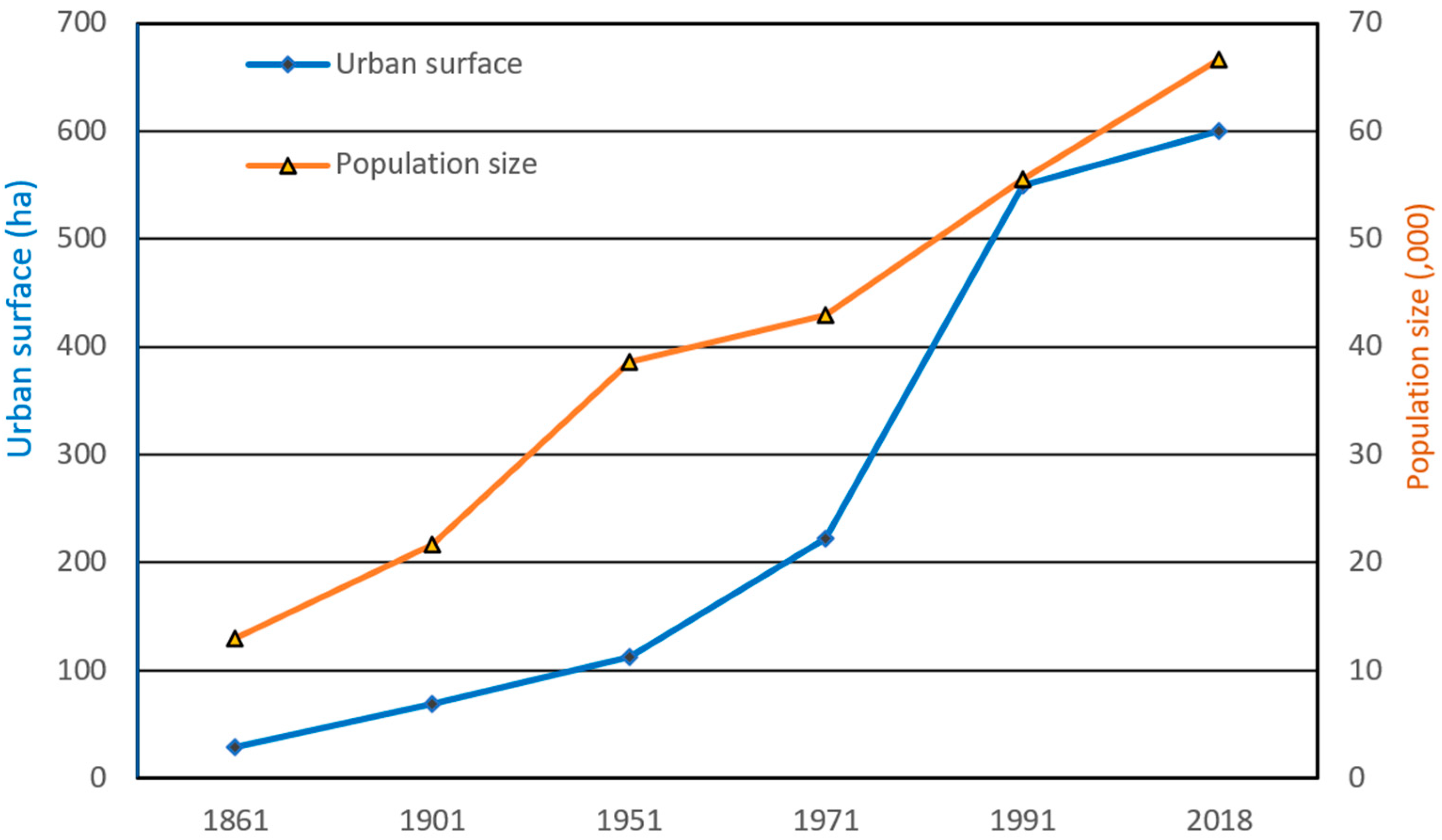
2.5. Urban Expansion
Between 1852 and 2018, the urban footprint of Bagheria expanded dramatically—from approximately 20.05 hectares to 467.55 hectares—representing more than a twenty-fold increase over a span of 166 years (
Figure 4). The most rapid phase of this expansion occurred between 1950 and 1990, a period during which the built-up area nearly quintupled. This trajectory reflects a wider post-war urbanization pattern observed across Italy and the broader Mediterranean, where economic reconstruction, demographic shifts, and speculative real estate activity catalyzed rapid land consumption and fragmented peri-urban development [
19,
23,
24].
Population growth mirrors these spatial transformations. Historical records show that Bagheria’s population increased from 5349 residents in 1826 to 55,373 in 2016—a tenfold increase. The most pronounced demographic acceleration occurred in the decades following World War II, driven by internal migration from inland rural zones to coastal and peri-urban areas, where employment opportunities and infrastructure investment were more concentrated [
25,
26]. This socio-demographic shift reinforced the demand for housing and services, further intensifying construction pressures.
However, this urban growth unfolded largely in the absence of effective spatial governance. Despite the national planning framework introduced with Law No. 1150/1942, Bagheria’s Piano Regolatore Generale (PRG) was inconsistently implemented, contested in local political arenas, and frequently outpaced by actual construction. Informal settlements, building amnesties (
condoni edilizi), and weak enforcement mechanisms enabled uncontrolled expansion—dynamics that are well documented in studies on Southern Italy’s urbanization processes [
11,
12].
The consequences for Bagheria’s landscape were significant. Once characterized by productive citrus groves, vineyards, and terraced agricultural systems, the rural matrix surrounding the historic villas has been extensively eroded. Baroque estates that were originally conceived as monumental residences in expansive green spaces became increasingly isolated within unplanned and low-quality residential developments. This spatial engulfment reduced both their visibility and territorial legibility, undermining their conservation and severing functional ties with the surrounding agricultural landscape [
2,
3].
Choropleth maps (
Figure 4) illustrate Bagheria’s urban transformation across four key benchmark years: 1852, 1900, 1954, and 2018. Urbanized areas, shown in dark gray, are overlaid on a beige background representing the residual rural land. In 1852, the built-up core was a compact nucleus centered on the historical town, with surrounding land dominated by citrus orchards and agro-industrial estates. By 1900, modest expansion reflected gradual urbanization in the wake of Italian unification. A sharper transformation is evident by 1954, coinciding with the post-war construction boom, while by 2018, the maps reveal a dispersed, fragmented urban morphology with significant loss of agricultural land and widespread spatial discontinuity.
The accompanying bar chart quantifies this land consumption, highlighting an increase from approximately 20.05 hectares in 1852 to 467.55 hectares in 2018. The steepest rise occurred between 1954 and 2018, a period that aligns with Italy’s economic boom, rapid suburbanization, and intensification of informal construction. These developments exacerbated the marginalization of cultural landscapes, particularly the Baroque villa system, by embedding heritage assets in amorphous and often degraded urban fabrics.
This pattern is consistent with broader Mediterranean urbanization syndromes, in which traditional agro-cultural systems and heritage landscapes are fragmented by poorly regulated expansion, especially along coastal and peri-urban belts. The literature increasingly emphasizes how such processes threaten not only ecological connectivity and landscape resilience, but also intangible heritage values, including cultural identity, traditional land use knowledge, and sense of place [
22,
27].
The Bagheria case exemplifies these dynamics with particular clarity. It underscores the urgent need for integrated landscape planning frameworks capable of reconciling urban development with cultural heritage conservation and ecological sustainability.
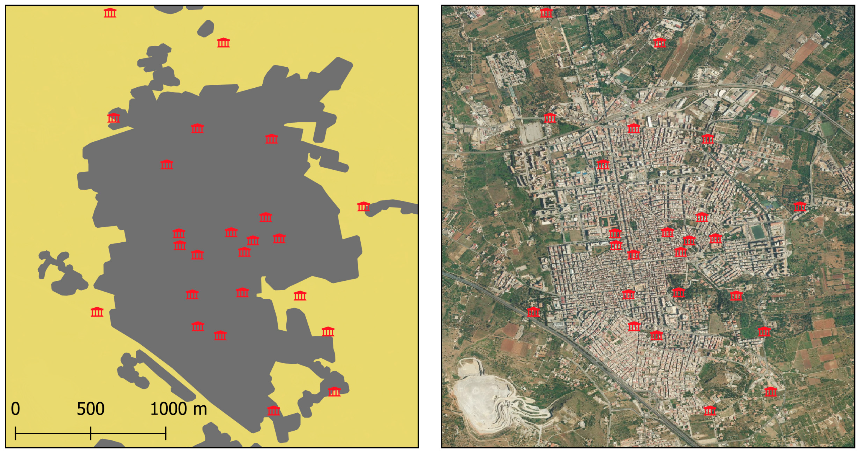
Figure 5 offers a spatially explicit visualization of how post-1950s urban expansion has reshaped the territorial context and visibility of Bagheria’s Baroque villas. Originally conceived as autonomous monumental residences within expansive agricultural estates, many of these heritage structures are now entirely or partially engulfed by the densifying urban fabric. This spatial encroachment has resulted in the loss of critical visual corridors and ecological buffers, the disruption of historical axial alignments, and a substantial diminishment of the symbolic, esthetic, and functional prominence of the villas. Consequently, numerous villas face heightened risks of structural deterioration, pollution exposure, and socio-functional obsolescence.
At the same time,
Figure 6 reveals a contrasting pattern: a subset of villas remains located along the southern and western peri-urban fringes, where residual connectivity to rural landscapes persists. These villas still retain elements of their original territorial logic, preserving tangible and intangible relationships with the surrounding agro-cultural matrix. Their spatial location renders them particularly suitable for landscape-sensitive planning interventions, such as the establishment of agro-heritage parks, cultural itineraries, educational gardens, or integrated agri-tourism nodes. These areas offer critical opportunities for regenerating the heritage–landscape interface while promoting community engagement and rural identity continuity.
From a planning and regulatory standpoint, the spatial distribution illustrated in this figure emphasizes the urgent need to delineate and institutionalize buffer zones around heritage assets. Integrating these protections within regional planning instruments—such as the Piano Territoriale Paesaggistico Regionale (PTPR) and the Piano Regolatore Generale (PRG)—is essential for mitigating development pressures and ensuring long-term conservation. Furthermore, the map facilitates the identification of “priority action zones,” where the intersection of high villa density and intense urban stress justifies targeted policy interventions, financial investment, and regulatory reinforcement. These findings resonate with international landscape planning principles that advocate for layered protection mechanisms, adaptive reuse models, and the integration of heritage into broader sustainable territorial governance frameworks.
2.6. Impact on Historical Villas
The Baroque villas of Bagheria were originally conceived as autonomous architectural compositions within expansive agricultural estates, embodying the aristocratic model of
villeggiatura that characterized 17th- and 18th-century Sicily [
28]. Far from being isolated residences, these complexes constituted integrated cultural landscapes. Their design combined formal geometries, axial visual perspectives, citrus groves, ornamental gardens, and water features, with deliberate spatial relationships to Mount Pellegrino, the Aspra coast, and the fertile Conca d’Oro basin [
3,
29]. This compositional logic—centered on isolation, legibility, and the interplay of architecture and agrarian function—was foundational to the villas’ symbolic and esthetic significance.
From the mid-20th century onward, however, Bagheria experienced rapid and poorly regulated urbanization that profoundly disrupted this territorial configuration. Between the 1950s and 1990s, speculative real estate development intensified, engulfing many villas in fragmented, unplanned urban fabric. This development was often facilitated by legal loopholes, building amnesties, and a lack of enforceable planning instruments, as widely documented in the literature on Southern Italy’s urbanization patterns [
11,
12]. As a result, historic citrus gardens were replaced by parking lots and apartment buildings, and axial paths were severed by incoherent road grids. The symbolic centrality of the villas—once reinforced by their isolation—was replaced by spatial marginalization and visual invisibility.
Many villas now exhibit pronounced physical deterioration, including structural collapse, vandalism, and abandonment. Only a small number have been subject to formal conservation or adaptive reuse. Notable exceptions include Villa Cattolica, currently hosting the Renato Guttuso Museum, and Villa Butera, partially repurposed for municipal use (Comune di Bagheria, 2021) [
30]. These cases illustrate the potential of reactivation strategies to reconnect heritage sites with the urban social fabric. However, such interventions remain sporadic and uncoordinated, lacking systemic integration into urban regeneration frameworks or landscape governance tools [
10].
GIS-based spatial analysis (
Figure 1,
Figure 2,
Figure 3,
Figure 4,
Figure 5 and
Figure 6) supports these findings. By overlaying villa locations onto diachronic urban expansion layers, the study confirms the loss of ecological and visual continuity between villas and their surrounding landscapes. Formerly interlinked estates have been fragmented into isolated architectural remnants, often surrounded by high-density development. This spatial rupture diminishes their interpretive value as components of a coherent territorial system and undermines their function as carriers of cultural memory [
1,
2].
These processes are not unique to Bagheria. Across the Mediterranean, similar cases highlight the vulnerability of historical estates to peri-urbanization. The Appian Way in Rome, for instance, is emblematic of aristocratic landscapes increasingly compromised by infrastructure development and urban sprawl [
31]. In the Bay of Naples, the coastal villas and agricultural systems have been similarly degraded by tourism-driven construction and informal settlements [
32]. In each case, the lack of landscape-sensitive planning and weak integration of heritage policy into territorial instruments have resulted in the erosion of both tangible assets and the intangible values tied to spatial legibility, place identity, and socio-ecological memory.
The Bagheria case thus reinforces the importance of moving beyond a monument-centered paradigm of preservation. It calls for integrated conservation approaches that account for the broader ecological, morphological, and symbolic dimensions of rural heritage. These approaches must be embedded in multi-scalar planning frameworks, capable of connecting local adaptive reuse initiatives with regional landscape strategies (e.g., PTPR) and national cultural heritage objectives.
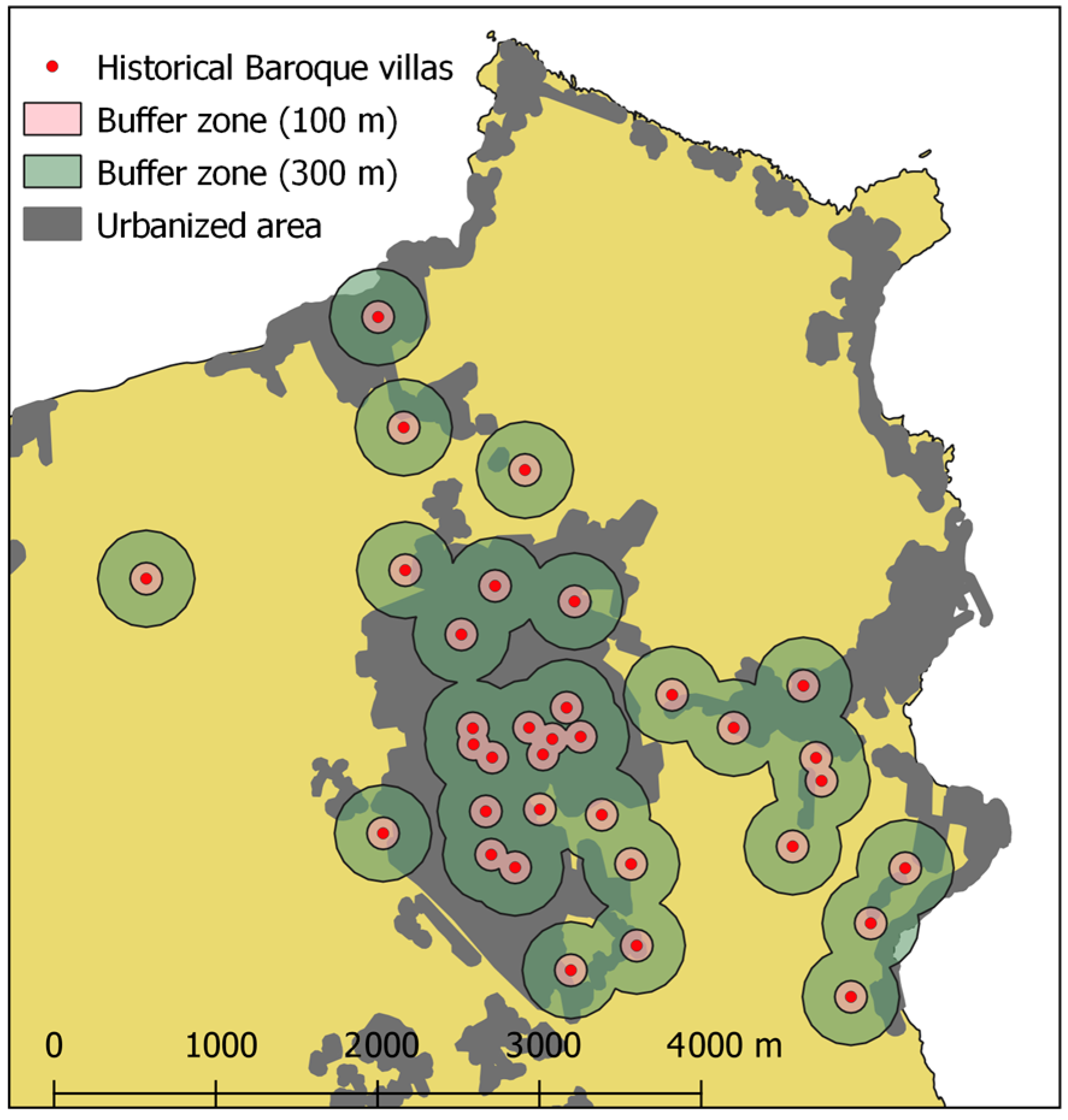
Figure 7 maps the spatial relationship between the urbanized area of Bagheria (as of 2018) and the historical network of Baroque villas. Each villa is depicted by a black dot, while concentric buffer zones of 0–100 m and 100–300 m illustrate degrees of spatial exposure to urban encroachment. The dark gray polygon represents the current built-up area, and the beige background denotes the remaining rural land cover. This visualization highlights the widespread loss of protective spatial buffers and the progressive fragmentation of villa landscapes. The spatial configuration underlines the urgent need for regulatory buffers, protective zoning, and integrated territorial governance to safeguard heritage value, spatial coherence, and cultural legibility.
2.7. Case Study: Villa Butera and Villa Valguarnera
Two emblematic case studies—Villa Butera and Villa Valguarnera—exemplify the complex interactions between urban expansion, landscape fragmentation, and heritage degradation in Bagheria (
Figure 8). Both villas are central to the city’s Baroque heritage and represent distinct trajectories of transformation shaped by unregulated development and uneven conservation efforts.
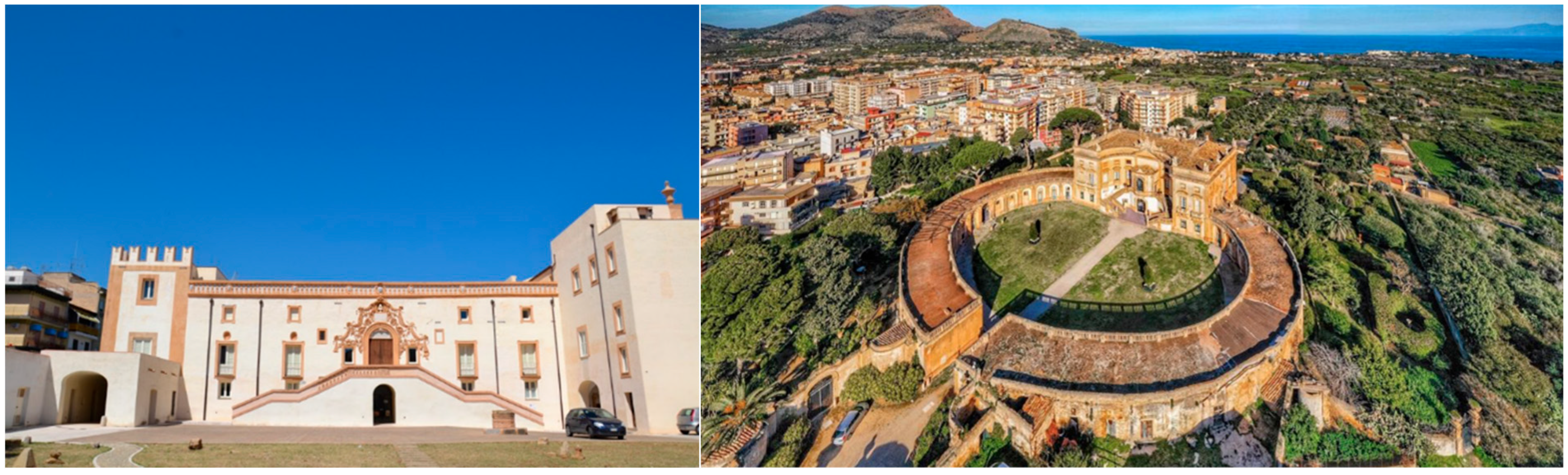
Villa Butera, commissioned in the early 18th century by the Branciforte family, was conceived as the nucleus of an aristocratic estate integrating architectural grandeur with agricultural productivity. Its original configuration included a formal axial layout, citrus groves, ornamental gardens, service structures, and open visual corridors extending toward the coastline. The villa’s scenographic relationship with the surrounding landscape was carefully orchestrated, reflecting the typological synthesis between residence, representation, and production typical of Sicilian Baroque architecture [
33].
Today, Villa Butera is completely engulfed by dense, low-quality urban fabric. The gardens have vanished, its façades are visually obstructed, and its historical spatial hierarchy has been dissolved. Much of the surrounding land was consumed by speculative housing construction between the 1950s and 1980s, often in the absence of effective planning regulation. Although the villa has undergone partial restoration and currently houses municipal functions, its symbolic and architectural presence has been substantially diminished by the loss of its spatial and landscape context. This situation highlights the limitations of monument-focused conservation policies that fail to address the territorial and perceptual dimensions of heritage sites.
Villa Valguarnera, widely regarded as “the most sumptuous of the Bagheria villas” [
29], was built by the Valguarnera-Gangi family and features a distinctive concave façade, an elevated panoramic terrace overlooking the Gulf of Palermo, and interior frescoes attributed to Elia Interguglielmi. It remains one of the most architecturally intact examples of aristocratic rural architecture in Sicily, retaining key structural elements and portions of its original garden system.
However, even Valguarnera has not been immune to landscape erosion. Beginning in the mid-20th century, successive waves of “lottizzazione”—the informal subdivision and sale of land for residential development—compromised its buffer zones, obstructed historical visual corridors, and severed its ecological connections with the surrounding rural matrix. Although the villa retains esthetic and architectural integrity, it has lost much of its territorial legibility and functional integration within the agro-cultural landscape [
33].
These two case studies underscore a broader problem: the inadequacy of traditional heritage protection instruments that prioritize the conservation of architectural form while neglecting the contextual, landscape, and functional dimensions of historical rural estates. The fates of Villa Butera and Villa Valguarnera demonstrate that preserving heritage meaningfully requires more than physical restoration; it calls for comprehensive, landscape-based protection strategies, the regulation of buffer zones, and the integration of these sites into sustainable territorial planning.
Both cases support the argument for adopting integrated conservation models that combine adaptive reuse, public accessibility, and contextual rehabilitation with digital tools for dissemination and education. Initiatives such as cultural itineraries, interpretive signage, and digital storytelling platforms can reanimate the cultural narratives embedded in these estates while promoting community engagement and sustainable tourism [
34,
35].
2.8. Adaptive Reuse and Smart Heritage Strategies
The historical villa system of Bagheria offers a strategic testing ground for contemporary models of adaptive reuse and smart heritage integration, reflecting a growing international emphasis on multifunctional, technology-supported, and community-driven approaches to heritage valorization. While a few successful cases—such as the transformation of Villa Cattolica into the Museo Renato Guttuso—demonstrate the feasibility of converting aristocratic estates into cultural infrastructures, the vast majority of Baroque villas in Bagheria remain underutilized, degraded, or entirely neglected. This persistent marginalization stems from the absence of coordinated planning frameworks capable of aligning cultural conservation goals with urban development, economic revitalization, and social innovation.
Adaptive reuse is increasingly recognized as a sustainable and context-sensitive approach to heritage management. It involves reconfiguring historical buildings to accommodate new functions while preserving their architectural and symbolic identity. In contexts such as Bagheria—where resources for full restoration are scarce—adaptive reuse represents a pragmatic strategy for reintegrating heritage into everyday urban life. Villas could be transformed into public libraries, cultural centers, co-working hubs, agro-food laboratories, or educational spaces, thereby enhancing their relevance for local communities and embedding them in the socio-economic fabric of the city.
The experience of Ortigia Island in Siracusa, as analyzed in [
34], provides a transferable model. There, the coordinated use of European Cohesion Funds, integrated territorial strategies, and public–private partnerships enabled the reactivation of historic buildings through a variety of residential, touristic, and cultural uses. Crucially, the success of this model depended on multi-level governance, strong civic participation, and sustainable maintenance mechanisms. Applying a similar approach in Bagheria would require the creation of regulatory incentives, fiscal instruments, and a participatory governance platform that links heritage conservation to urban innovation.
In parallel, the incorporation of smart technologies into heritage conservation—known as smart heritage—offers new opportunities for both preservation and public engagement. Internet of Things (IoT) systems can monitor structural integrity and environmental conditions; augmented reality (AR) and virtual reality (VR) platforms can enable immersive interpretations of lost or transformed landscapes; geolocated mobile applications can enhance interpretive storytelling; and digital twin models can simulate scenarios for adaptive reuse and landscape planning [
36].
In Bagheria, initial explorations in this direction have been proposed by the Smart Heritage Network [
37], which envisions the deployment of intelligent lighting systems, video surveillance, and user-oriented digital services across historical urban zones. Although these projects remain in a preliminary phase, their scaling and institutionalization could position Bagheria as a pilot site for digitally augmented heritage valorization within the Mediterranean region.
Ultimately, the convergence of adaptive reuse and smart heritage strategies offers a multidimensional framework for cultural sustainability. By merging conservation with digital innovation and community activation, these models enable historical assets to transcend passive preservation and actively contribute to contemporary urban resilience, landscape continuity, and cultural identity. For cities like Bagheria, where decades of unregulated urbanization have undermined heritage landscapes, the urgent implementation of such integrated strategies is not only beneficial but essential.
3. Comparative Insights: Mediterranean Heritage Under Threat
The case of Bagheria exemplifies a broader and increasingly critical phenomenon occurring across the Mediterranean basin, where historic rural and suburban cultural landscapes are undergoing rapid transformation. Urban expansion, real estate speculation, mass tourism, and socio-economic restructuring have disrupted long-standing territorial equilibria, placing growing pressure on heritage systems historically characterized by continuity between architecture, agriculture, and landscape identity [
2,
27].
These changes are not merely the consequence of demographic growth or shifting economic dynamics. Rather, they stem from deeper structural vulnerabilities embedded within local and regional governance. Among the most significant are the fragmentation or outright absence of integrated cultural landscape policies, the marginal treatment of heritage conservation in spatial planning instruments, and the widespread diffusion of informal development, particularly in peri-urban zones [
25,
31]. The combined effect of these weaknesses is the gradual erosion of both tangible elements—such as historic buildings, orchards, and hydraulic systems—and intangible values, including territorial memory, identity, and spatial legibility.
Despite these challenges, several Mediterranean regions have begun to experiment with adaptive reuse models, territorial planning integration, and landscape-sensitive regeneration. In certain contexts, the alignment of heritage policies with ecological infrastructure, sustainable tourism, and community-led development has produced promising, though often isolated, results [
10]. These emerging practices underline the need to rethink heritage conservation as part of a wider territorial strategy rather than a sectoral concern.
Within this framework,
Table 2 offers a comparative lens through which to analyze Bagheria alongside other emblematic sites in Southern Europe, such as Ortigia (Italy), the Appian Way in Rome, and the Hills of Athens (Greece). Each of these territories faces similar tensions between historical continuity and contemporary urbanization, yet they display differentiated trajectories in terms of governance, policy response, and community engagement. This comparative approach reveals recurrent vulnerabilities—such as the absence of regulatory buffer zones or the fragmentation of historic green infrastructures—but also highlights successful mitigation strategies, including landscape-based planning tools, inter-institutional cooperation, and public–private investment in adaptive reuse.
Situating Bagheria within this comparative framework allows for the identification of key lessons. First, it reinforces the importance of embedding heritage protection within broader spatial governance structures capable of addressing ecological, social, and economic dimensions simultaneously. Second, it stresses the relevance of participatory mechanisms, in which local communities contribute to the redefinition of cultural assets through co-designed reuse and storytelling. Third, it illustrates how territorial synergies between agriculture, culture, and tourism can generate viable alternatives to speculative development models.
Rather than being considered a singular case of heritage decline, Bagheria should be viewed as part of a shared Mediterranean geography of risk and potential. Through this perspective, its landscape may serve as both a critical diagnostic and a laboratory for testing integrated models of resilient, heritage-led regeneration that respond to the complex realities of urban–rural transition in the twenty-first century [
22,
35].
These comparative insights demonstrate that heritage districts across the Mediterranean—despite differences in geographic scale, historical trajectories, and governance frameworks—are increasingly subject to a set of convergent structural challenges. Core among these are urban sprawl, mass tourism, informal construction, and socio-spatial displacement, which together undermine the integrity, authenticity, and functionality of historic environments. Critically, these pressures sever the continuity between built heritage and its broader cultural, ecological, and territorial matrices, thereby diminishing both symbolic value and functional adaptability [
1,
2,
27].
However, the cases analyzed also underscore that these dynamics are not irreversible. Where targeted, context-sensitive interventions have been implemented—ranging from zoning protections and participatory planning processes to EU-funded regeneration projects and smart heritage monitoring systems—there is evidence of enhanced resilience, increased public engagement, and the generation of long-term territorial value. These strategies highlight the potential for innovative conservation to act as a catalyst for integrated development rather than a constraint on growth.
Within this broader framework, Bagheria should not be perceived as a peripheral anomaly or isolated case of cultural degradation. Rather, it should be repositioned as a potential laboratory for multi-scalar heritage-led regeneration. The city’s network of Baroque villas, when understood as part of a territorial system rather than isolated monuments, presents opportunities for experimenting with new forms of adaptive reuse, landscape reconnection, and digitally enabled interpretation. From the activation of ecological and cultural itineraries to the implementation of geospatial monitoring systems and augmented reality storytelling, Bagheria could serve as a testing ground for practices that bridge static preservation with dynamic territorial innovation.
Comparable experiences reinforce this view. In Ortigia (Siracusa), integrated urban regeneration policies have supported the reactivation of historic buildings through tourism and cultural programs. In Barcelona’s Ciutat Vella, urban heritage policies have addressed gentrification and displacement through social housing, mobility control, and cultural zoning. In Athens, new digital and civic platforms are being used to map and interpret archeological layers embedded in the contemporary urban fabric. In each case, cross-sectoral governance and long-term strategic planning have been essential to repositioning heritage as an active component of sustainable development [
35].
Accordingly, the Baroque villas of Bagheria should be reframed not simply as threatened cultural assets but as strategic territorial nodes capable of anchoring broader agendas of urban resilience, social cohesion, and landscape regeneration. Their adaptive reuse could support a diversified local economy, enhance environmental sustainability, and promote inclusive forms of cultural participation.
Figure 5 offers a comparative cartographic visualization of selected Mediterranean heritage districts under pressure, each accompanied by the dominant threats identified through the literature and spatial diagnostics. In Bagheria, uncontrolled urban sprawl encroaches upon the historic villa system; in Siracusa, tourism saturation endangers the balance between everyday life and cultural overexposure; in Barcelona’s Ciutat Vella, gentrification and residential displacement alter the social fabric; in Athens, chronic underfunding and structural decay threaten archeological continuity; and in the Roman periphery, illegal parceling and landscape fragmentation erode rural–urban thresholds. This comparative mapping synthesizes GIS-based analysis and qualitative heritage assessments, offering a spatially explicit basis for future coordinated actions in Mediterranean heritage policy and planning.
4. Discussion
The findings of this study highlight the progressive marginalization of Bagheria’s Baroque villa system, now mostly isolated within dense and often low-quality residential developments. This spatial fragmentation reflects decades of unregulated urban expansion, speculative land subdivision, and weak territorial governance—dynamics widely reported across Mediterranean towns where historical rural landscapes lack integrated protection and planning frameworks [
36,
37].
Although Bagheria’s degradation is not unique, the comparative analysis presented in this study offers valuable lessons. For example, in Ortigia (Siracusa), successful adaptive reuse has been enabled by coordinated access to EU structural funds, the presence of a unified conservation-management framework, and targeted investment in cultural tourism [
38,
39]. In contrast, Athens—despite its rich architectural heritage—experiences fragmented conservation efforts due to incoherent planning and limited civic engagement [
40]. Similar governance gaps are observed in the Ciutat Vella district of Barcelona, where gentrification processes threaten social diversity despite significant heritage value [
41]. These comparisons suggest that successful heritage safeguarding depends not only on the architectural significance or legal protection of the sites but on broader socio-institutional factors, such as coherent urban policies, the availability of public and private funding, administrative capacity, and community participation [
42,
43].
In Bagheria, initiatives such as the cultural itinerary
La città delle ville and proposals for adaptive reuse represent promising starting points for restoring the social and cultural relevance of the villa system. However, their success hinges on the adoption of supportive policy frameworks and governance mechanisms. Instruments such as restoration grants, tax incentives for conservation, and public–private partnerships have proven effective in other European contexts [
38,
44] and could encourage property owners in Bagheria to invest in safeguarding heritage. Without such instruments, adaptive reuse efforts risk remaining isolated and insufficient to reverse long-term degradation trends.
Persistent barriers include limited funding, regulatory complexity, bureaucratic inertia, and the reluctance of private owners to engage in structured conservation programs. Moreover, the historical lack of integration between cultural heritage strategies and urban development policies has constrained the transformative potential of even well-conceived projects, as demonstrated in similar Mediterranean peri-urban contexts [
36,
37].
To overcome these barriers, future interventions should adopt a systemic, cross-sectoral approach, positioning cultural heritage as a key component of urban resilience, ecological connectivity, and inclusive development [
35,
38]. In this regard, Bagheria could become a replicable model for Mediterranean regions facing similar pressures. Its villa system could anchor innovative territorial strategies reconnecting architecture, landscape, and community through multi-scalar approaches that combine conservation, ecological planning, and digital engagement [
38,
42].
The GIS-based reconstructions presented in this study provide compelling visual and quantitative evidence of the spatial rupture experienced by Bagheria’s historical landscape. Urban encroachment has impacted not only the physical fabric of the Baroque villas but has also dismantled their functional, visual, and symbolic relationships with the surrounding environment. Former citrus groves, scenic corridors, hydraulic infrastructures, and axial paths—central to the villas’ spatial logic and symbolic power—have been fragmented, erased, or rendered illegible. These transformations mirror those observed in other Mediterranean peri-urban landscapes where rapid urbanization and demographic pressures have fragmented historic rural territories [
45,
46].
As highlighted in the comparative framework of
Section 3, similar dynamics are evident across the Mediterranean basin. In Siracusa, the historic center is increasingly saturated by tourism [
39] in Barcelona’s Ciutat Vella, gentrification and housing pressure undermine heritage continuity [
41] in Athens, policy incoherence and underfunding impede preservation [
40] on the Roman periphery, with unauthorized urbanization fragments on agrarian and cultural landscapes [
47]. More resilient cases distinguish themselves through the adoption of integrated, long-term governance frameworks where cultural heritage is embedded within broader territorial strategies [
38,
43].
Successful examples include Ortigia, where cohesion policies and a unified conservationmanagement framework enabled systematic heritage reactivation [
38,
39], and the Appian Way in Rome, where coordinated zoning and landscape protection policies support long-term safeguarding [
47]. In Bagheria, isolated successes such as the conversion of Villa Cattolica into the Museo Renato Guttuso illustrate the adaptive reuse potential of heritage assets. However, without an overarching territorial vision, such initiatives remain fragmented. A coherent strategy is needed—one that reimagines the villa system not as a collection of decaying monuments but as a dynamic cultural infrastructure supporting multifunctional territorial development.
This strategy could include thematic itineraries, immersive storytelling, and the deployment of smart heritage technologies such as augmented reality, digital twins, and IoT-enabled monitoring systems [
38,
42]. Such tools, already applied in several European heritage contexts, can enhance public engagement, enable predictive maintenance, and stimulate creative reuse scenarios connecting heritage with tourism, education, and the local economy [
44].
Crucially, the Bagheria case demonstrates the need to shift from monument-centric conservation to a landscape-based perspective. Protecting isolated buildings without restoring their ecological, visual, and spatial contexts risks reducing them to disconnected relics. The Historic Urban Landscape (HUL) approach proposed by UNESCO [
35] provides a useful framework, emphasizing the restoration of ecological corridors, view axes, multifunctional public spaces, and the integration of heritage into everyday urban life. This approach aligns with emerging European urban sustainability strategies, where heritage, landscape, and community are seen as interdependent dimensions of resilient territorial systems [
37,
43].
Finally, the interdisciplinary methodology adopted in this study—combining historical cartography, GIS-based spatial analysis, fieldwork, and demographic interpretation—demonstrates a replicable model for assessing peri-urban heritage landscapes under pressure. Similar methodologies have been applied to the Douro Valley [
36], the Catalan peri-urban forest remnants [
46], and the Andalusian olive landscapes [
48]. These approaches enable evidence-based diagnostics, support participatory scenario-building, and provide practical frameworks for aligning heritage conservation with urban resilience and territorial regeneration. As Mediterranean cities face the dual challenges of heritage loss and unregulated growth, interdisciplinary, cross-sectoral approaches such as this will be essential for more integrated and sustainable territorial planning.
5. Conclusions
This study investigated the long-term transformation of Bagheria’s rural architectural system, revealing how decades of unregulated urban expansion have fragmented the cultural landscape and compromised the integrity of its Baroque villas. Through a combined methodology involving diachronic cartography, GIS-based spatial analysis, architectural field surveys, and a comparative review of Mediterranean heritage contexts, the research documented a gradual but profound erosion of landscape continuity and heritage legibility. Bagheria’s villas, once conceived as autonomous monumental residences embedded in productive estates, are now largely engulfed by disjointed urban fabric, which has diminished their symbolic prominence and functional relevance.
Despite the severity of these challenges, the study highlights the potential for heritage-led territorial regeneration. Comparative insights from other Mediterranean contexts—such as Siracusa, Barcelona, Athens, and Rome—demonstrate that adaptive reuse, when linked with landscape planning and supported by digital technologies, can transform historic environments into dynamic cultural assets. These examples affirm that heritage, far from being a static relic, is capable of generating ecological resilience, economic diversification, and civic identity when managed through integrated and participatory frameworks.
In the case of Bagheria, the proposed thematic itinerary La città delle ville offers a strategic approach to reconnect the dispersed villa system with the contemporary urban and territorial fabric. This initiative not only enhances visibility and accessibility but also repositions the villas as nodes within a broader cultural and ecological infrastructure. The incorporation of digital storytelling platforms, augmented reality applications, and location-based cultural apps can further strengthen public engagement, diversify tourism flows, and support educational initiatives. When embedded within local planning strategies and reinforced through public–private restoration partnerships, this model offers a replicable and sustainable path for revitalizing underutilized heritage.
The adoption of the UNESCO Historic Urban Landscape (HUL) approach provides a critical conceptual and operational framework for advancing such efforts. By shifting from a monument-centric preservation paradigm to one that prioritizes landscape-scale integration, the HUL model emphasizes spatial continuity, ecological coherence, and functional adaptability. Applying this perspective in Bagheria would entail reinforcing zoning regulations, preserving view corridors and cultural buffer zones, and fostering multifunctional land use that aligns heritage with environmental sustainability and urban resilience.
From a policy perspective, it is imperative to align heritage conservation with municipal and regional planning instruments such as the PRG and PTPR, ensuring that cultural assets are recognized not only for their historical value but also for their role in shaping future urban development. Fiscal incentives such as tax relief and restoration grants, combined with simplified regulatory pathways and institutional coordination, could incentivize private owners to participate in conservation and adaptive reuse. In parallel, smart technologies—including structural monitoring systems, digital twin models, and geospatial data platforms—should be leveraged to enhance conservation efficiency, enable predictive diagnostics, and facilitate immersive user experiences.
A crucial dimension of this agenda involves engaging local communities through participatory planning processes and educational initiatives. Empowering residents, students, and cultural associations to contribute to heritage narratives and stewardship fosters social ownership and ensures that conservation efforts are grounded in local identity and memory. Reclaiming the spatial, ecological, and symbolic functions of Bagheria’s villas therefore requires a multi-scalar strategy that integrates cultural heritage with territorial governance, landscape ecology, and socio-economic innovation.
Ultimately, the safeguarding and revitalization of Bagheria’s Baroque villas should not be interpreted as a retrospective gesture of preservation, but rather as a forward-looking strategy for spatial justice, cultural sustainability, and inclusive urban development. The methodological framework adopted in this study—combining spatial diagnostics, field-based evaluation, and comparative Mediterranean analysis—provides a transferable model for addressing similar heritage challenges in peri-urban territories. By placing cultural heritage at the core of territorial policy, Bagheria can reclaim its historical identity while actively contributing to the reimagining of a more sustainable, resilient, and culturally enriched Mediterranean urban future.


 ,
, 


