Article

Effects of Vegetation Heterogeneity on Butterfly Diversity in Urban Parks: Applying the Patch–Matrix Framework at Fine Scales

1
School of Design and Architecture, Zhejiang University of Technology, Hangzhou 310023, China
2
Research Institute of Forestry, Chinese Academy of Forestry, Beijing 100091, China
3
Urban Forest Research Centre, National Forestry and Grassland Administration, Beijing 100091, China
4
China Railway Fifth Survey and Design Institute Group Co., Ltd., Beijing 102600, China
*
Author to whom correspondence should be addressed.
Sustainability 2025, 17(14), 6289; https://doi.org/10.3390/su17146289
Submission received: 10 June 2025 / Revised: 1 July 2025 / Accepted: 7 July 2025 / Published: 9 July 2025

Abstract

(1) Background: Urban parks play a critical role in conserving biodiversity within city landscapes, yet the effects of fine-scale microhabitat heterogeneity remain poorly understood. This study examines how land cover and vegetation unit type within parks influence butterfly diversity. (2) Methods: From July to September 2019 and June to September 2020, adult butterflies were surveyed in 27 urban parks across Beijing. We classified vegetation into units based on vertical structure and management intensity, and then applied the patch–matrix framework and landscape metrics to quantify fine-scale heterogeneity in vegetation unit composition and configuration. Generalized linear models (GLM), generalized additive models (GAM), and random forest (RF) models were applied to identify factors influencing butterfly richness (Chao1 index) and abundance. (3) Results: In total, 10,462 individuals representing 37 species, 28 genera, and five families were recorded. Model results revealed that the proportion of park area covered by spontaneous herbaceous areas (SHA), wooded spontaneous meadows (WSM), and the Shannon diversity index (SHDI) of vegetation units were positively associated with butterfly species richness. In contrast, butterfly abundance was primarily influenced by the proportion of park area covered by cultivated meadows (CM) and overall green-space coverage. (4) Conclusions: Fine-scale vegetation patch composition within urban parks significantly influences butterfly diversity. Our findings support applying the patch–matrix framework at intra-park scales and suggest that integrating spontaneous herbaceous zones—especially wooded spontaneous meadows—with managed flower-rich meadows will enhance butterfly diversity in urban parks.

1. Introduction

Urbanization is progressing rapidly worldwide, with estimates indicating that approximately 57.25% of the world’s population currently lives in urban regions [1], and this percentage is expected to rise to 68% by 2050 [2]. With the intensification of urban growth, cities have become not only hubs of human activity but also essential habitats for diverse species [3,4]. Butterflies, widely recognized as sensitive indicators of ecological change, have undergone substantial population declines, largely due to habitat loss, vegetation alteration, and increased anthropogenic disturbances [5,6]. Urban green spaces, especially parks, have become important refuges for biodiversity [7,8]. However, most urban butterfly studies have focused on landscape-scale factors such as green space connectivity and urban intensity, while the role of fine-scale vegetation heterogeneity within parks remains poorly understood. Identifying environmental features that influence butterfly communities is essential for urban biodiversity conservation and ecologically sensitive urban green space design.
Recent studies on urban butterflies examine both landscape-level spatial patterns and local-level habitat conditions [9,10,11]. While urban insect diversity is shaped by factors across multiple spatial scales [12], research at intermediate scales suggests that habitat quality—particularly regarding plant resources availability, vegetation structure, and understory composition—often plays a more decisive role than broader urbanization metrics [13,14,15]. Urban green spaces often exhibit fine-scale internal fragmentation due to the diversity in vegetation structure and composition, resulting in variable habitat quality [16]. Some butterflies show habitat response at fine spatial scales because of their limited dispersal range and strong site fidelity. The combination of urban park features including impervious surfaces and roads creates movement barriers for these butterflies which results in survival conditions similar to those found in landscape mosaics. The patch–matrix framework becomes applicable at intra-park scales through the understanding of urban parks as habitat mosaics which consist of different vegetation units with distinct structural and functional characteristics. Urban parks, as distinctive social-ecological systems, are shaped by a mix of intentional design, horticultural management, and spontaneous ecological processes [17,18]. Unlike natural habitats, their spatial structure reflects both human intentions and site-specific environmental conditions, resulting in inherently complex spatial structures. As Forman describes, urban habitats vary along gradients of vegetation origin and dominant processes, from fully planted to spontaneously developed vegetation, and from intensive human maintenance to natural succession [19]. Examining the ecological impacts of this structural complexity in human-created green areas is essential for the preservation of urban butterflies.
Nonetheless, typical management techniques—like regular mowing, trimming, and mulching—can streamline habitat structures and diminish ecological heterogeneity [17]. Numerous studies have found connections between particular vegetation traits and butterfly diversity within urban green areas. Unmanaged vegetation units, tree-covered habitats, and natural grasslands in urban parks typically support higher butterfly diversity than intensively managed areas [7,20,21,22,23]. However, simple comparisons between habitat types cannot fully explain the effects of microhabitat configuration heterogeneity. Microhabitat heterogeneity in urban parks is recognized as a determinant of biodiversity [24]. Increased habitat diversity typically reflects environmental variability and is often associated with higher biodiversity [25]. This may partly explain why species–area relationships are stronger in larger parks, which typically harbor more diverse microhabitat types [26,27]. Yet, this relationship is not always linear: Lizée et al. [28] demonstrated that, when summarized as the diversity and fragmentation of habitat units, park characteristics were negatively related to butterfly richness (and abundance). This highlights simultaneous examination of habitat composition together with spatial configuration at detailed spatial scales.
Landscape ecology offers both theoretical and methodological approaches to studying spatial heterogeneity and biodiversity relationships through metrics such as patch size, edge density, and shape complexity. The patch–matrix model has been widely used at regional scales [29,30], but its applicability at fine spatial scales, such as within individual parks, remains uncertain. Park can be conceptualized as micro-scale matrices containing a mosaic of habitat patches [9,31]. Landscape metrics can help quantify the composition and configuration of these vegetation units [32], potentially revealing how spatial patterns shape biodiversity. The predictability of habitat heterogeneity’s effects on butterfly species richness has been shown to decrease with decreasing geographic scale [33]. This raises questions about whether microhabitat heterogeneity effectively predict butterfly diversity at very fine scales, and whether the patch–matrix concept from landscape ecology can be effectively applied to studying biodiversity within individual parks. Despite the importance of fine-scale changes in habitat spatial patterns for biodiversity [34], knowledge regarding optimal fine spatial patterns of urban green spaces for biodiversity conservation remains limited [35].
This study built on previous work at the same sites [13,36] in Beijing urban area, and focused on the influence of fine-scale land cover and vegetation-unit spatial configuration on butterfly diversity. We classified vegetation units according to their vertical structure and management intensity to characterize intro-park microhabitat patterns. We then applied generalized linear models (GLMs), generalized additive models (GAMs), and random forest (RF) models to assess the effects of these spatial characteristics on butterfly species richness and abundance, testing the following hypotheses: (1) Intra-park microhabitat heterogeneity (i.e., variation in land cover and vegetation unit types) influences butterfly community diversity. (2) Butterfly species richness and butterfly abundance respond differently to changes in intra-park microhabitat heterogeneity. (3) Coverage of specific vegetation units—such as spontaneous herbaceous areas (SHA)—positively promotes butterfly diversity.

2. Materials and Methods

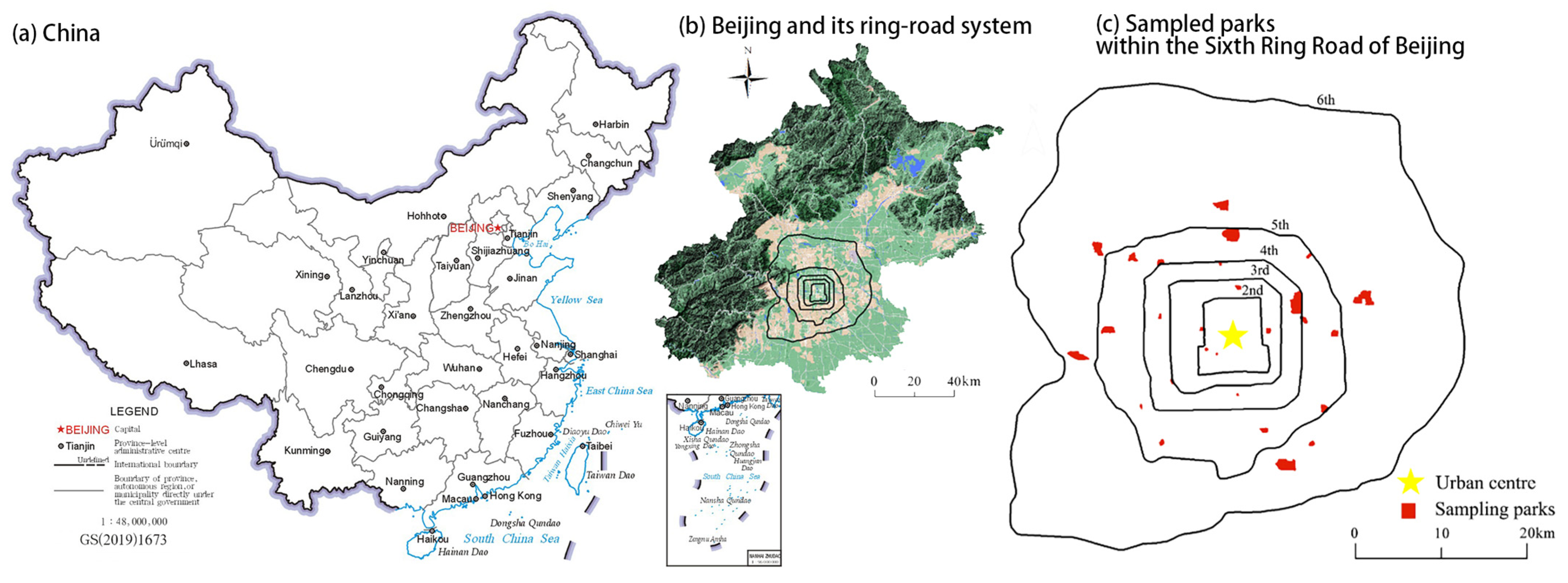
2.1. Study Area and Study Sites

This study area is located in Beijing, the capital of China and lies in the northern section of the North China Plain. The study area spans 2273 km2 inside the Sixth Ring Road (39°28′–41°05′ N, 115°20′–117°30′ E) and consists mainly of plains. As a megacity, Beijing supports more than 21 million residents while undergoing fast urban development through its beltway system [37]. Beijing has a north temperate zone sub-humid continental monsoon climate, with four distinct seasons. The city experiences high temperatures and rain in summer and cold, dry winters. We sampled 27 parks distributed evenly throughout Beijing’s urban area along eight geographical directions (Figure 1, see also Table S1 for full details on park size, age, and spatial distribution [13]).

2.2. Butterfly Surveys

The research used distance sampling transects together with random quadrat surveys to achieve complete butterfly diversity assessment. We established quadrat and transects in each park combining park size with vegetation unit heterogeneity to achieve optimal spatial coverage and sampling consistency. The research established between 2 and 12 quadrats in each park. When a vegetation unit was too small to accommodate a full 20 m × 20 m plot, an alternative plot with an equivalent area (400 m2) was used. Transects ranging from 0.5 to 9 km in length were distributed along pathways to cover the entire park area, maintaining a minimum parallel distance of 100 m between adjacent transects to avoid overlap. In total, 160 quadrats and 75 km of transects were surveyed across 27 urban parks (more detailed information in Table S1). During transect walks, observers moved at a consistent pace and recorded all adult butterflies encountered within a virtual observation zone extending 2.5 m to each side, 5 m in front, and 5 m above the observer [38]. Each 500 m segment of transect took approximately 20 min to complete. To ensure consistency in the survey effort, the timer was paused if observers had to slow down, temporarily leave the transect path, or follow individuals for species identification. Timing resumed once the observer returned to the transect line. Each 400 m2 quadrat was surveyed for a standardized duration of 10 min. Whenever feasible, observers followed a fixed walking path within each quadrat to achieve even coverage. In plots with dense vegetation or limited accessibility, one observer remained at the center, while the other surveyed along the perimeter. We prioritized quadrats that allowed for safe and consistent access.
From July to September 2019 and June to September 2020, each transect and quadrat was surveyed once per month. All surveys were conducted by two trained observers with taxonomic expertise in the butterflies of Beijing. Species identity and individual abundance were recorded simultaneously during field sampling. The observers recorded butterflies from 08:00 to 17:00 during favorable weather conditions which included clear skies or less than 50% cloud cover, temperatures above 20 °C, and wind speeds below 20 km/h [38]. To minimize biases associated with weather or diurnal butterfly activity, the order of transect and quadrat surveys was randomized for each monthly session. When possible, butterflies were identified directly through visual observation. If reliable species-level identification could not be achieved in the field, individuals were temporarily captured using insect nets for closer examination. When field identification remained inconclusive, individuals were collected and brought back to the laboratory for further identification using regional field guides [39] and local species checklists [40].

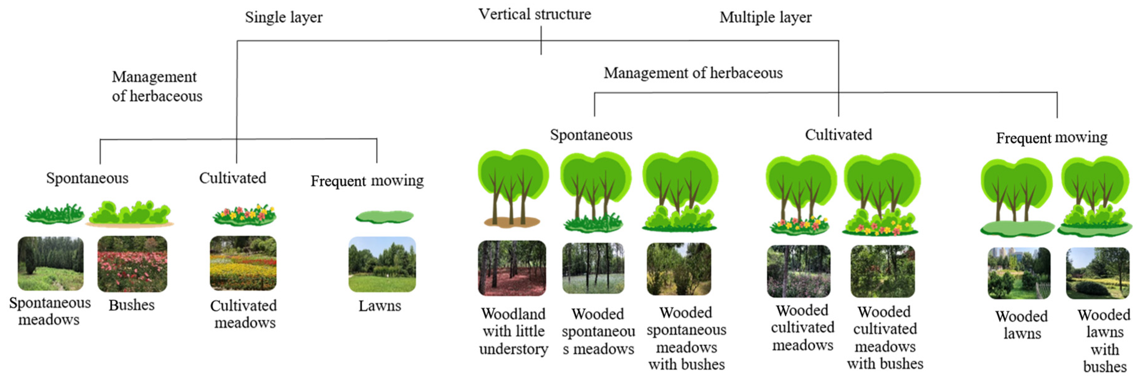
2.3. Mapping of Vegetation Units and Spatial Metrics of Green Spaces

The vegetation in urban parks exists mainly because of human intervention through deliberate design and ongoing maintenance activities particularly in megacities such as Beijing. Woody vegetation, such as trees and shrubs, is typically planted and maintained through horticultural practices. Herbaceous layer displays wide-ranging differences in its origins and management practices, which include regular lawn mowing and ornamental flower beds with cultivated species as well as areas with minimal intervention that allow spontaneous vegetation to grow. In some peri-urban parks, areas of naturally regenerating vegetation are also retained, forming semi-natural plant communities. This compositional and management diversity represents a gradient of vegetation origin and dominant management processes within urban habitats, from intensively maintained artificial units to near-natural successional systems [19]. Such heterogeneity is particularly pronounced in large, multifunctional parks located at the urban–rural fringe.
We drew on Marie-Hélène Lizée’s approach to mapping vegetation units in Marseille’s urban parks [28], and adapted it to the Beijing context. We first conducted detailed field surveys to delineate vegetation units within each park. Park land cover was initially classified into four broad categories: green space, water bodies, bare ground, and impervious surfaces (e.g., buildings, roads, and paved plazas). We then further subdivided all vegetated areas into 11 distinct vegetation units based on the following dimensions: (1) vertical structural layering (e.g., combinations of tree, shrub, and grass layers), (2) vegetation origin (planted vs. spontaneous), and (3) horticultural maintenance (e.g., ornamental management, lawn-type mowing, or minimal intervention). Bamboo groves were treated as an independent vegetation unit due to their distinct structure and ecological function. (Figure 2; classification following [36]).
Vegetation unit boundaries and canopy cover were manually digitized in ArcGIS 10.2 using high-resolution Google Earth imagery (~1 m resolution) from the 2019 growing season as the primary base map. Additional imagery from the winter of 2019 was used to assist in the delineation of impervious surfaces, as reduced canopy density allowed better visualization of ground features. The tree canopy cover was mapped separately. All vegetation units and patch boundaries were delineated during the 2020 field survey period. We combined small transitional patches (less than 10 m2) with adjacent dominant vegetation units to prevent over-fragmentation and maintain ecological interpretability. These thresholds ensured consistency and ecological relevance in patch delineation across all sampled parks.
Landscape metrics are widely used to characterize and measure patterns of green space [32]. To characterize the composition of land cover in the urban parks, we calculated the percentage of each land cover type, including 12 specific vegetation units, green spaces, water bodies, bare land, and impervious surfaces (Table 1). Moreover, we calculated the tree canopy percentage and management intensity (Table 1). The percentage of lower management intensity was estimated as the proportion of areas growing spontaneous herbs in park. Areas generally covered by spontaneous herbs tend to have a lower horticulture management intensity; therefore, we considered the areas covered by spontaneous herbs to have low-intensity management. We treated vegetation units as patches and calculated Shannon’s diversity index (SHDI), Shannon’s evenness index (SHEI), and the area-weighted mean patch shape index (AWMSI) to quantify the spatial patterns of vegetation units within the parks. The metrics’ description and computation were performed in FRAGSTATS 4.2, using the “8-cell rule” to define patch neighbors [32]. The 8-cell rule considers patches as connected if they share either edges or corners (i.e., all eight surrounding cells), as opposed to the 4-cell rule which only considers edge-sharing connections.

2.4. Data Analysis

This study employed clustering analysis, analysis of variance (ANOVA), generalized linear models (GLMs), generalized additive models (GAMs), and random forest (RF) models to examine the effects of green space characteristics and vegetation unit composition within urban parks on butterfly diversity and abundance. We selected these three modeling approaches (GLMs, GAMs, and RF models) because each provides complementary insights into ecological data. GLMs offer interpretable linear relationships and are widely used for hypothesis testing [41]. GAMs allow flexible modeling of nonlinear ecological responses without assuming a specific functional form [42]. RF models, being ensemble machine learning methods, are robust to multicollinearity, automatically capture complex interactions, and provide variable importance rankings [43,44]. Because our dataset comprised a relatively small sample size but a high number of potential predictors, combining these three approaches allowed us to balance statistical power, flexibility in detecting non-linear effects, and robustness. Concordance among the three approaches strengthens inference, whereas discordance highlights model dependency, thereby informing cautious interpretation [45].

2.4.1. Diversity and Abundance Indices

Butterfly diversity was evaluated using the Chao1 richness estimator, which accounts for undetected species and provides a more robust estimation of true species richness, particularly in communities with numerous rare species [46]. Butterfly abundance was standardized across parks by calculating the average number of individuals observed per 60 min of survey effort.

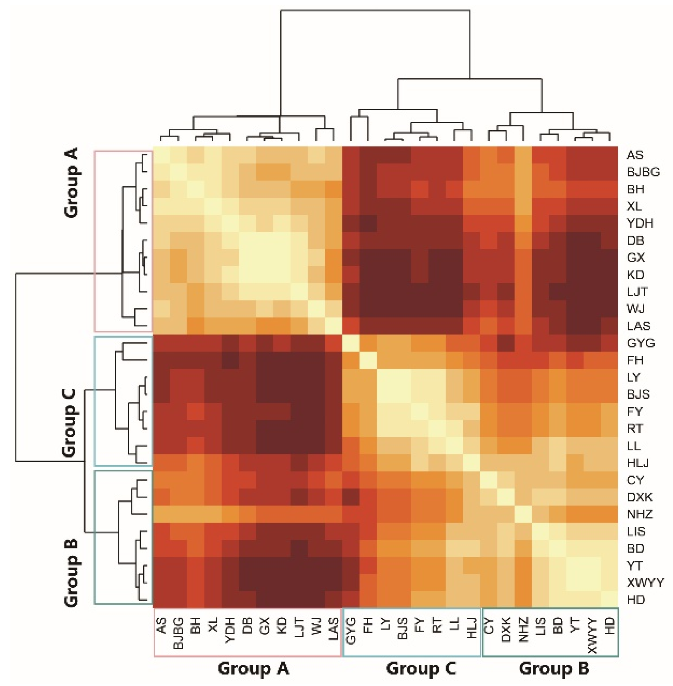
2.4.2. Clustering Analysis

Cluster analysis was performed to classify the sampled parks based on the composition of vegetation unit types. Percentage coverages of vegetation units served as input variables. Euclidean distance was used to quantify dissimilarity, and Ward’s minimum variance method guided hierarchical clustering.

2.4.3. Analysis of Variance (ANOVA)

To examine differences in butterfly diversity and abundance among the park groups identified through clustering, we first assessed the normality of response variables using the Shapiro–Wilk test. For butterfly abundance, log transformation was applied during exploratory analysis when it improved normality. However, if variables remained non-normally distributed after transformation, non-parametric Kruskal–Wallis tests were used, followed by Dunn’s multiple comparison tests. When parametric assumptions were met, one-way ANOVA was employed, and homogeneity of variances was tested using Bartlett’s test. Post hoc comparisons were conducted using Tukey’s Honestly Significant Difference (HSD) test, with statistical significance set at α = 0.05.

2.4.4. Generalized Linear Models (GLMs)

Four GLMs were constructed: two land structure explanatory variable models for Chao1 richness and two vegetation composition explanatory variables models for butterfly abundance. For Chao1 richness, quasi-Poisson error structures were used to account for overdispersion. For abundance per 60 min, Gamma distributions with log-link functions were employed. The land structure models incorporated seven standardized explanatory variables: Park Area (ParkArea), proportion of green space (Green), proportion of spontaneous herbaceous area (SHA), tree canopy coverage (Tree), Shannon diversity index (SHDI), Shannon evenness index (SHEI), and Area-Weighted Mean Shape Index (AWMSI). For vegetation composition models, the variables included the percentages of wooded cultivated meadows (WCM), wooded spontaneous meadows (WSM), wooded cultivated meadows with shrubs (WCMB), wooded spontaneous meadows with shrubs (WSMB), shrub areas (Bush), lawn areas (Lawn), and cultivated meadows (CM). Model optimization utilized the Akaike Information Criterion adjusted for small sample sizes (AICc) as the selection criterion. Models with ΔAICc < 2 were considered equally plausible, and model averaging was performed to derive robust parameter estimates.
Model diagnostics were conducted to validate the assumptions of the four generalized linear models (GLMs). Residual plots and Q–Q plots were visually inspected to assess homoscedasticity and normality of residuals. Additionally, Shapiro–Wilk tests were performed to statistically evaluate normality, and the Breusch–Pagan test was used to assess homogeneity of variance. Overdispersion was checked using both the dispersion ratio and Pearson residual deviance for quasi-Poisson and Gamma models. Influential observations were identified using Cook’s distance (threshold: 4/n) and leverage values (threshold: 2(k + 1)/n), where n is the sample size and k is the number of predictors in the model. While one data point in the richness–land structure model exhibited high Cook’s distance, it was retained to preserve model comparability, and its potential influence was noted in the discussion.
Leave-one-out cross-validation (LOOCV) was used to assess model performance in terms of prediction error (RMSE) and explanatory power (R2) across all GLM models. For each iteration, one observation was withheld as test data, and the model was re-fitted on the remaining samples. Predictions were then compared with actual values to compute performance metrics. This procedure was applied to model-averaged results derived from the top-ranked models (ΔAICc < 2).

2.4.5. Generalized Additive Models (GAMs)

Generalized Additive Models were constructed separately for Chao1 richness and abundance using thin plate regression splines. These models mirrored the structures of the GLMs in terms of explanatory variables. All models were fitted using restricted maximum likelihood (REML), which automatically controls model complexity by optimizing the trade-off between fit and smoothness [42], thereby reducing the risk of overfitting—particularly important given the relatively small sample size. We retained full models rather than conducting AICc-based model selection, as highly parameterized GAMs may suffer from instability under small-sample AICc optimization.
Model assumptions were evaluated using diagnostic tools provided by the mgcv package [47]. Residual vs. fitted plots and Q–Q plots were visually inspected to assess homoscedasticity and residual distribution. The appropriateness of smooth terms was examined using the gam.check() function, which reports the estimated degrees of freedom (edf), p-values, and k-index values for each term. All k-index values exceeded 0.7, and p-values were >0.05, indicating adequate basis dimensions and no evidence of undersmoothing. To assess model performance and predictive robustness, we conducted leave-one-out cross-validation (LOOCV) for all GAMs. Predictive performance was quantified using the root mean squared error (RMSE) and adjusted R2 between predicted and observed values.

2.4.6. Random Forest Models (RF)

Random forest (RF) regression models were fitted to explore the relationships between butterfly richness (Chao1) or abundance (Abun) and two sets of predictors (land cover and vegetation type) using the randomForest package [48]. All predictor variables were standardized (z-score) prior to analysis. Each RF model was constructed with 500 trees (ntree = 500). Following reviewer suggestions, we performed hyperparameter tuning to optimize the number of variables randomly sampled at each split (mtry). We applied leave-one-out cross-validation (LOOCV) using the caret package with a custom tuning grid from 1 to the total number of predictors. Model performance was evaluated using the out-of-bag (OOB) R2 and LOOCV R2 and RMSE (root mean square error). After selecting the best mtry, final RF models were refitted and used to compute variable importance (%IncMSE). The top three predictors were used to generate partial dependence plots (PDPs) using the pdp package [49] to visualize ecological response curves.
All statistical analyses and some data visualizations were conducted using R version 4.3.2. The following R packages were utilized: vegan [50], lme4 [51], MuMIn [52], AICcmodavg [53], randomForest [54], pdp [49], circlize [55], ggplot2 [56], cowplot [57], and mgcv [47].

3. Results

3.1. Overall Characteristics

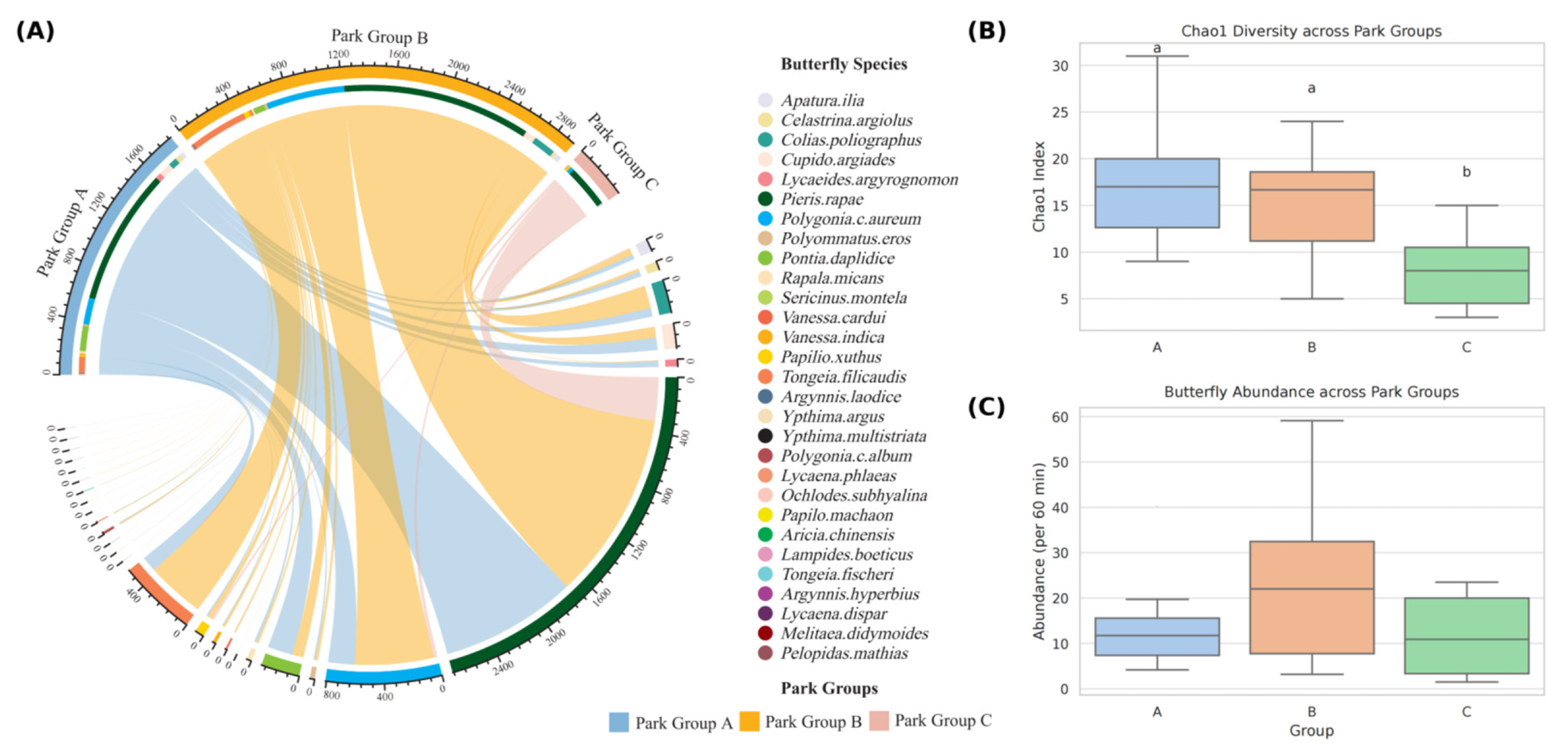
3.1.1. Overall Butterfly Community Composition

The 27 surveyed parks recorded 10,462 butterfly individuals, representing 37 species in 28 genera and five families (Table S2). Pieridae was the most abundant family, comprising five species and 6731 individuals (64.4% of the total). The next most numerous families were Pierinae (15 species, 1901 individuals; 18.2%), Lycaenidae (12 species, 1676 individuals; 16.0%), Papilionidae (3 species, 149 individuals; 1.4%), and Hesperiidae (2 species, 5 individuals; <0.1%). At the species level, Pieris rapae (Linnaeus, 1758) dominated the assemblage, accounting for 5445 individuals (52.0%). Other common species included Polygonia c-aureum (Linnaeus, 1758) (n = 1324, 12.66%), Tongeia filicaudis (Pryer, 1877) (n = 869, 8.31%), and Colias poliographus (Motschulsky, 1860) (n = 645, 6.17%). Twelve species were observed with fewer than 3 individuals, such as Sericinus montela (Gray, 1852), Fabriciana adippe (Butler, 1871), Neptis sappho (Pallas, 1771), Ypthima multistriata (Butler, 1883). Detailed taxonomic classifications and species abundances are provided in Table S2.

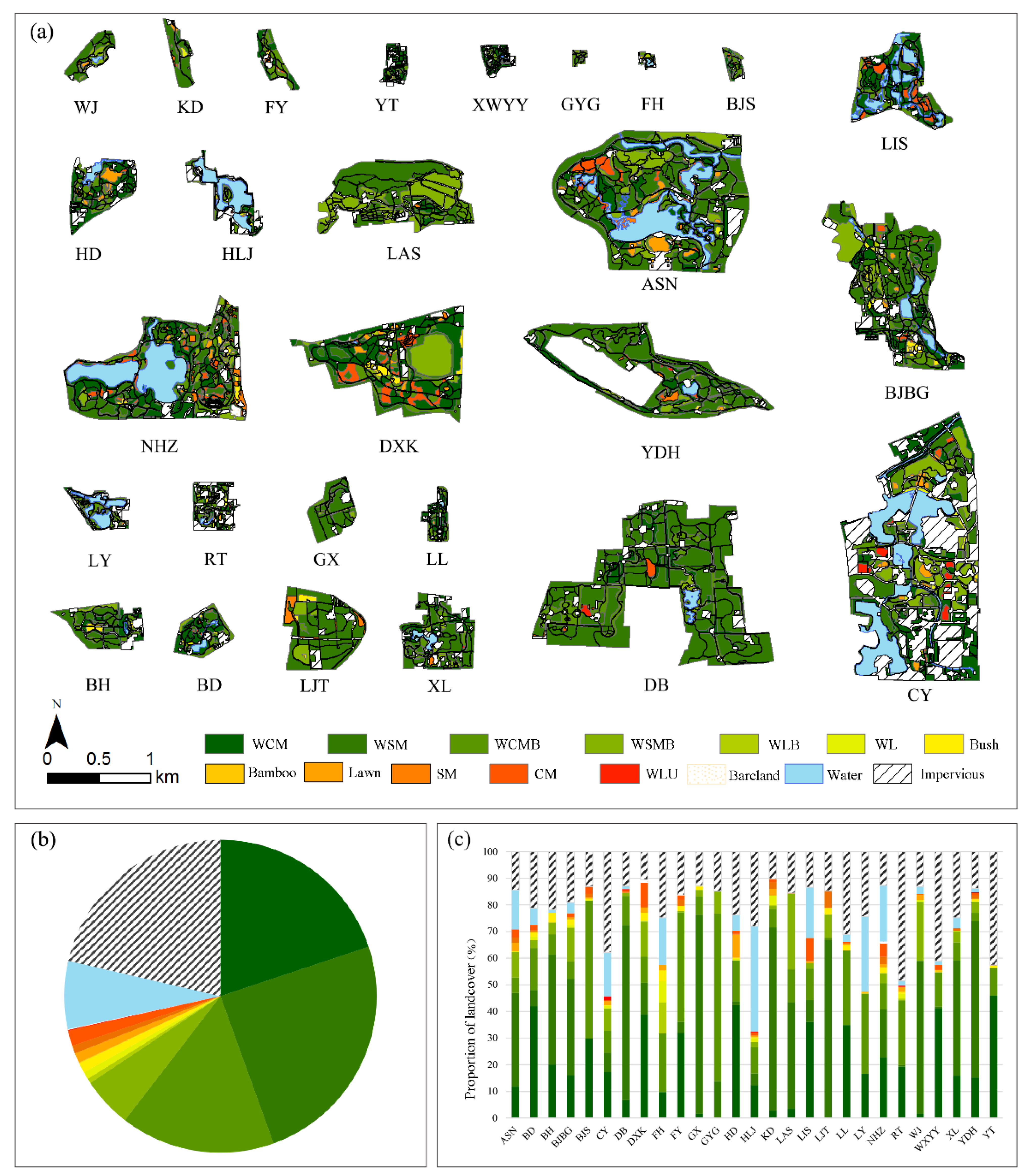
3.1.2. Intra-Park Land Cover and Vegetation Unit Composition

Across the 27 surveyed parks, green spaces covered an average 71.6% (±3.0% standard error), while impervious surfaces and water bodies accounted for 21.4% (±2.1% SE) and 7.0% (±2.0% SE), respectively. Spontaneous herbaceous areas (SHA) comprised 38.0% (±6.7% SE) of total park area and 53.1% of green space, indicating that SHA dominates the vegetated cover. Within green spaces, the relative abundance of vegetation units was as follows: wooded spontaneous meadows (WSM) 24.6%; wooded cultivated meadows (WCM) 19.9%; wooded cultivated meadows with bushes (WCMB) 16.0%; wooded spontaneous meadows with bushes (WSMB) 5.2%; cultivated meadows (CM) 1.6%; bushes 1.1%; and lawns 1.0% (Figure 3). Some additional vegetation types, including spontaneous meadows, wooded lawns, wooded lawns with bushes, woodlands with minimal understory, and bamboo groves, each represented less than 1% of the total park area (Figure 3). Detailed values of land cover and vegetation unit composition for each park can be found in Tables S3 and S4.

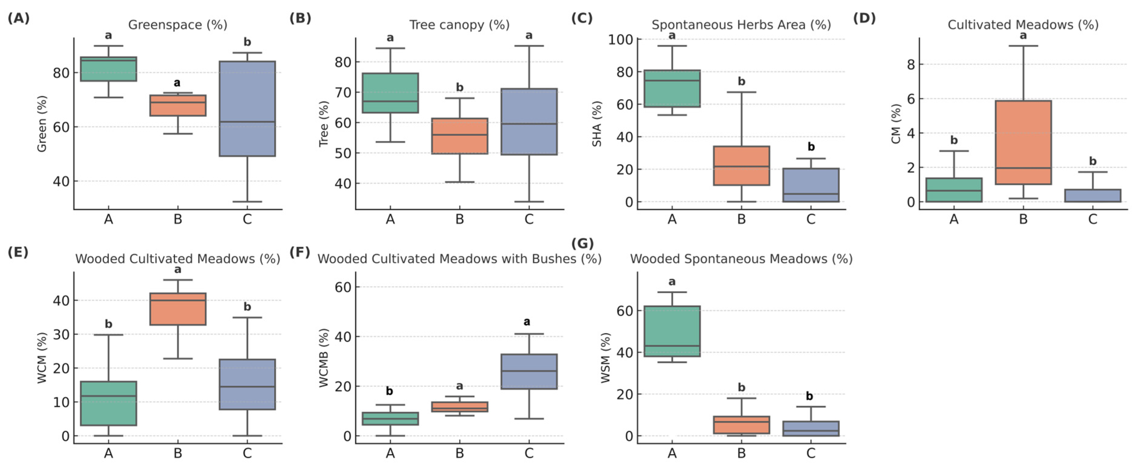
3.2. Comparison of Park Group Characteristics and Butterfly Diversity

We performed a hierarchical cluster analysis on the proportional composition of 11 vegetation units in each park, which identified three discrete park clusters (Figure 4). These groups exhibited clear differences in vegetation unit composition (Figure 5, Table S5). Group A parks were characterized by high shares of green space (80.31 ± 9.38%) and spontaneous herbs area (62.65 ± 32.79%), as well as a greater extent of wooded spontaneous meadows (46.61 ± 20.05%), reflecting a more naturalistic and less intensively managed vegetation feature. Group B showed significantly higher coverage of cultivated meadows (3.55 ± 3.59%) and wooded cultivated meadows (35.80 ± 10.23%), indicating a more intentionally designed and managed vegetation profile. Group C, by contrast, had the highest percentage of wooded cultivated meadows with bushes (28.09 ± 17.77%), while other vegetation indicators suggested intermediate or mixed vegetation characteristics.
Observed butterfly species richness per park varied substantially, ranging from 3 to 24 species, while standardized butterfly counts per 60 min also showed wide variation, from as few as 2 individuals to as many as 59 (Table S3). Butterfly richness also varied by park group (Figure 6B, Table S5). Chao1 diversity in Groups A and B was higher than in Group C by 16.8 ± 8.6 and 15.5 ± 5.6, respectively (p < 0.05). Standardized butterfly abundance (per 60 min) did not differ significantly among the three groups (Figure 6C; Table S5).
The chord diagram (Figure 6A) illustrates that generalist butterflies—such as Pieris rapae and Polygonia c-aureum—dominate all communities, although each park cluster exhibits a unique species assemblage. Eleven species were shared across all groups, indicating widespread generalists. Group A exhibited the greatest richness with 33 species, including 14 endemics such as Papilio machaon (Linnaeus, 1758), Sericinus montela, and Pelopidas mathias (Fabricius, 1798) Group B contained 23 species, 4 of which were unique—e.g., Tongeia fischeri (Eversmann, 1843), Argynnis hyperbius (Linnaeus, 1763), Lycaena dispar (Haworth, 1802), and Lampides boeticus (Linnaeus, 1767). Group C had the lowest richness (11 species) and no exclusives. Full species list and abundances are provided in Table S6.

3.3. Drivers of Butterfly Diversity

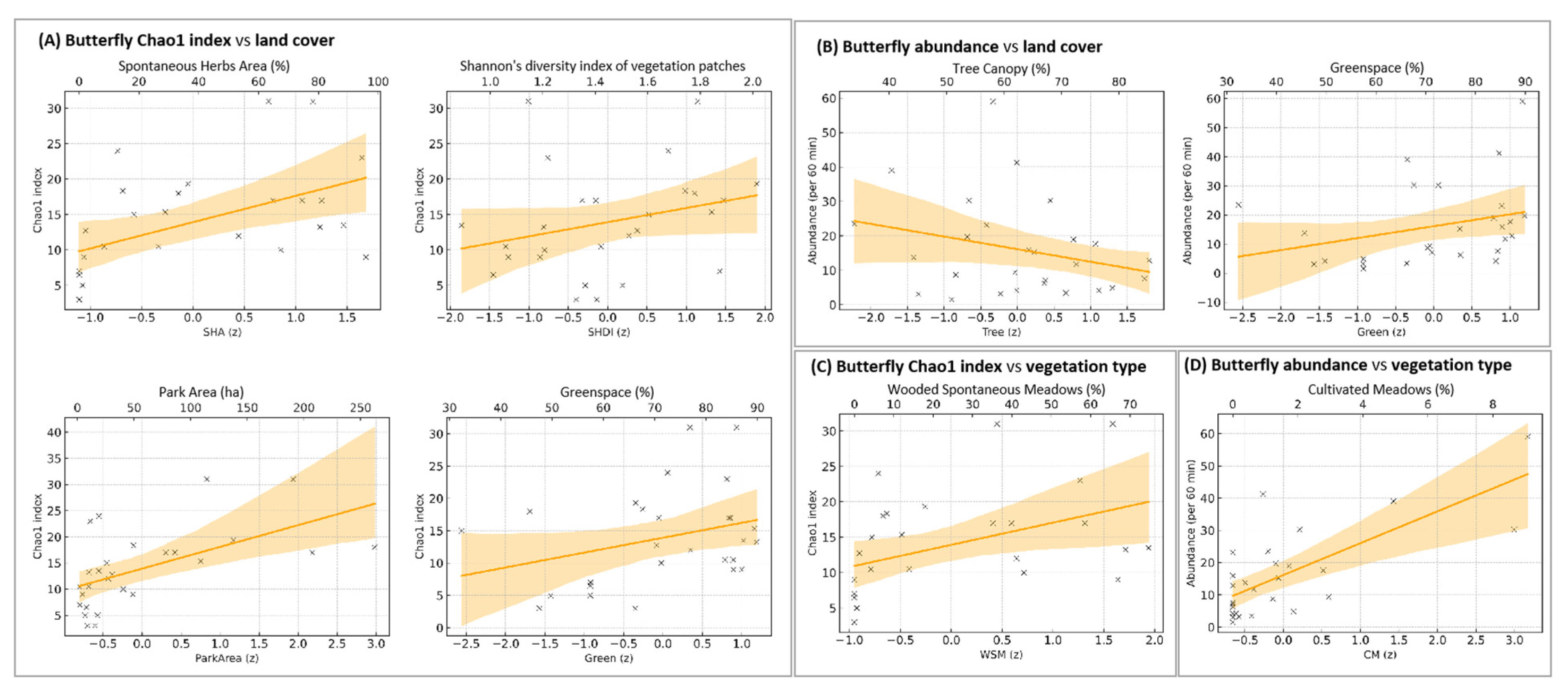
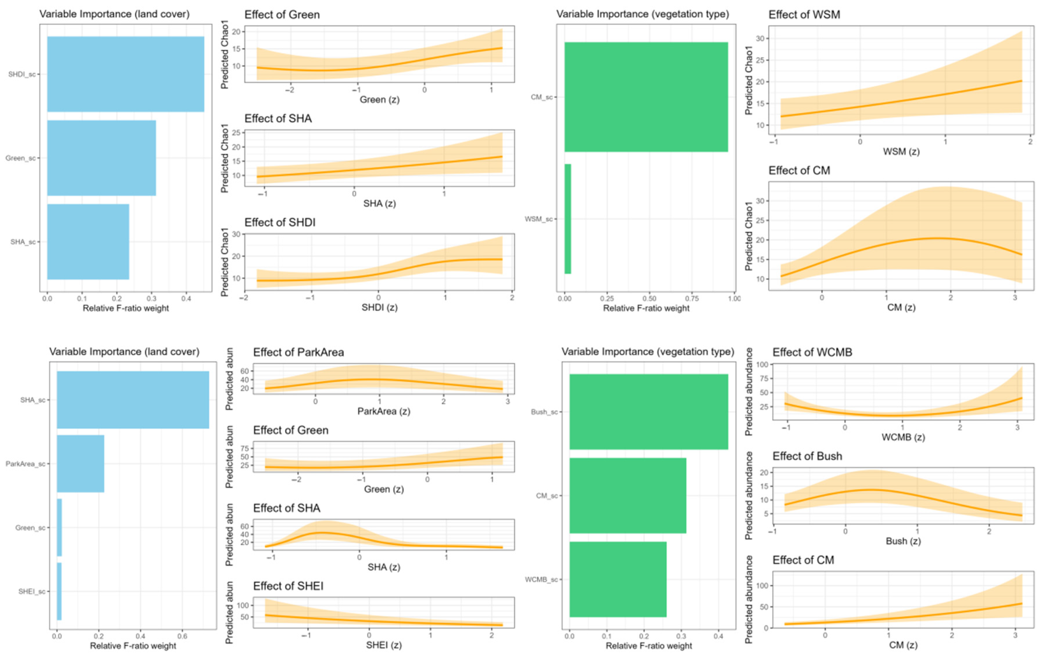
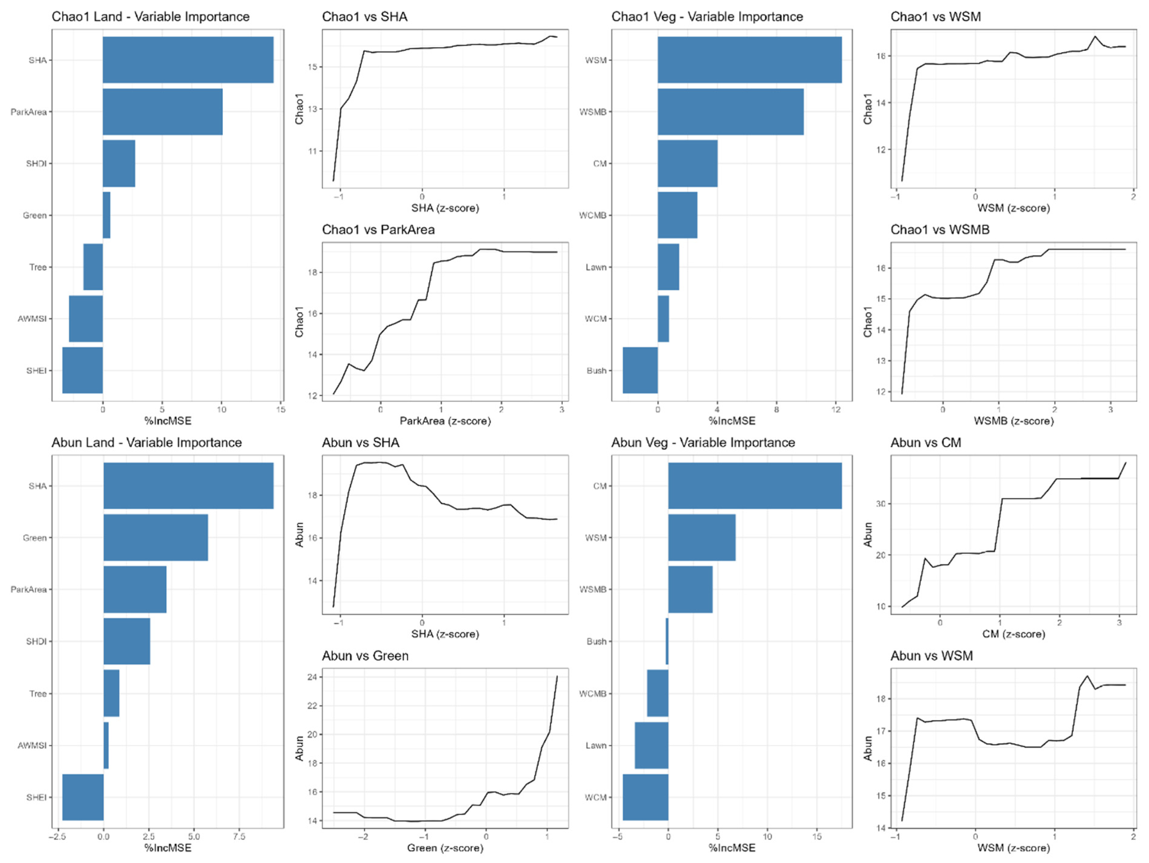
3.3.1. Effects on Butterfly Species Richness

In the GLM using land cover variables to predict Chao1 richness (adjusted R2 = 0.518), model-averaged results indicated that SHA, SHDI, ParkArea, and Green all had significant positive effects (conditional average estimate: SHA = 3.93, p = 0.0098; SHDI = 3.55, p = 0.045; ParkArea = 3.253, p = 0.045; Green = 2.491, p = 0.04) (Figure 7A, full results in Table S7). In the corresponding GLM based on vegetation variables (Adj. R2 = 0.349), WSM was the only significant predictor (estimate = 0.12, p = 0.039), while CM showed a marginally non-significant positive effect (estimate = 0.12, p = 0.084) (Figure 7C, Table S7).
The GAM results further identified several significant predictors. In the land-cover GAM (Adj. R2 = 0.510; deviance explained = 54.4%), SHA (p = 0.0179), Green (p = 0.0393), and SHDI (p = 0.0119) were positively associated with species richness. In the vegetation-type GAM (Adj. R2 = 0.529; deviance explained = 55.3%), WSM (p = 0.0284) and CM (p = 0.0068) emerged as significant positive predictors (Figure 8, Table S8).
The RF models explained approximately 22% of variance in species richness when using land-cover variables (OOB R2 = 0.213; RMSE = 2.813) and vegetation-type variables (OOB R2 = 0.217; RMSE = 3.021). The most important predictors based on %IncMSE were SHA, ParkArea, and SHDI in the land cover model, and WSM and WSMB in the vegetation-type model (Figure 9, Table S9).
Together, across all three models (GLM, GAM, and RF), SHDI, SHA, and WSM consistently emerged as significant predictors of butterfly species richness. In contrast, ParkArea was identified as significant in GLM and RF models, and Green was identified as significant in GLM and GAM models.

3.3.2. Effects on Butterfly Abundance

In the GLM modeling butterfly abundance per 60 min using land-cover variables (Adj. R2 = 0.536), Green emerged as the strongest positive predictor (estimate = 0.63, p < 0.001), followed by a significant negative effect of tree canopy cover (Tree) (estimate = −0.56, p = 0.0018) (Figure 7B, full results in Table S7). The corresponding GLM based on vegetation-type variables (Adj. R2 = 0.579) identified CM as the only significant positive predictor (estimate = 0.22, p = 0.0012) (Figure 7D, Table S7).
The GAM using land-cover variables showed excellent performance (Adj. R2 = 0.730; deviance explained = 90.7%). SHA (p = 0.0010), Green (p = 0.0090), and ParkArea (p = 0.0228), and SHEI (p = 0.0017) all had significant positive effects. The vegetation-type-based GAM (Adj. R2 = 0.721; deviance explained = 66.6%) revealed CM (p < 0.0001), WCMB (p = 0.0046), and Bush (p = 0.0109) as a significant contributor (Figure 8, Table S8).
The RF models further supported these findings. The RF model using seven vegetation-type variables explained 26.9% of the variance in butterfly abundance (OOB R2 = 0.269, RMSE = 5.181), while the land cover model showed negligible predictive performance (OOB R2 = 0.01, RMSE = 6.417). In the vegetation-type model, CM (15.72), WSM (7.36), and WSMB (2.60) ranked highest in importance (%IncMSE) (Figure 9, Table S9).
Together, across all three models (GLM, GAM, and RF), Green and CM consistently emerged as significant predictors of butterfly abundance. In contrast, Parkarea, SHA, SHEI, Tree, WSM, WSMB, WCMB, and Bush were significant in some of the models.
To evaluate predictive robustness, we additionally assessed model performance using leave-one-out cross-validation (LOOCV). GLM models generally maintained comparable LOOCV R2 to training performance for both Chao1 and abundance, while RF models showed slightly higher predictive accuracy for richness (LOOCV R2 = 0.28) than for abundance (LOOCV R2 = 0.26). In contrast, GAMs—despite achieving high adjusted R2 (up to 0.73)—exhibited negative LOOCV R2 values for abundance models, suggesting limited generalization capacity (Table S10).

4. Discussion

4.1. Butterfly Community in Beijing Urban Parks

A 2017 survey within Beijing’s Sixth Ring Road documented 31 butterfly species, 19 of which (61%) were represented by fewer than five individuals, and nearly half of all captures were Pieris rapae [58]. In our study of 27 parks, we observed 37 species, 19 of which were represented by fewer than ten individuals—again illustrating a high proportion of low-abundance taxa—while overall abundance was dominated by just a few generalist species (Table S2). Given this skewed distribution, although Chao1 is widely regarded as a conservative estimator of species richness, it may overestimate true richness when species detectability is highly uneven. Notably, this “few dominant species + many rare species” pattern mirrors findings from other cities, where disturbance-tolerant generalists prevail and specialists persist at low densities [59,60]. For example, a study in Japan found that generalist butterflies occurred universally at high densities, making them the most abundant community members [61]. Meanwhile, specialists and rarer species were scarce—a trend frequently attributed to the strong filtering effects of urbanization on sensitive taxa [62]. For instance, the Lampides boeticus was once widespread across the Beijing plain prior to the 20th century [40] yet we recorded only three individuals in our surveys, underscoring its dramatic decline with urban expansion. In Beijing, the adult flight period of most butterfly species spans from June to August, corresponding to peak temperatures and resource availability. Our sampling spanned the peak adult butterfly activity periods over two consecutive years (June–September in 2019 and 2020), and was supplemented by a comprehensive one-month survey in May 2021 for check. Although no additional species were recorded during this May survey [63], we cannot rule out the possibility that some early-spring-active species were overlooked.

4.2. Fine-Scale Microhabitat Heterogeneity Drives Butterfly Richness

The coverage of spontaneous herbaceous areas (SHA) positively affected butterfly species richness, in line with studies from other regions and on different taxa. For instance, Sylwia Pietrzak observed in post-industrial wastelands of Łódź, Poland, that sites with greater microhabitat diversity and a mix of plant species supported richer butterfly communities [64]. Similarly, ruderal sites with naturally reestablished vegetation supported higher butterfly diversity than conventional urban parks in Malmö, Sweden [65]. These findings align with the premise that heterogeneous, minimally managed habitats with native flora (like meadows) enhance urban biodiversity [12,20,21].
Within spontaneous herbaceous areas, the presence of wooded spontaneous meadows—a structurally complex and ecologically diverse vegetation unit—was identified as a particularly influential component. An increasing volume of understory flora in urban green spaces has a positive impact on biodiversity, particularly benefiting native species [66]. Wooded spontaneous meadows combine the benefits of spontaneous vegetation with the additional structural complexity provided by tree canopies, creating multilayered microhabitats. Canopy-level attributes, such as tree cover, have been shown to make significant contributions to butterfly diversity [67]. Such habitats may provide diverse host plant assemblages, and reduced anthropogenic disturbance, which are essential for various butterfly species [18,66]. For instance, wooded spontaneous meadows in our study parks typically contained native herbaceous species such as Rumex spp. that serve as larval host plants for locally adapted butterfly species, such as Lycaena phlaeas (Linnaeus, 1761) and Lycaena dispar, while the canopy cover provided thermal refugia during Beijing’s hot summers. In contrast to intensively managed areas, vegetation units under pollinator-friendly management (e.g., little managed or no mowing) tend to maintain ecological continuity, supporting not only generalist species but also habitat specialists sensitive to urban disturbance [68]. The reduced frequency of disturbance allows for the persistence of long grasses, native flora, litter layers, and microhabitat complexity, which are essential for the full life cycles of many insect taxa [16,68,69,70]. These areas tend to maintain stable plant communities, which in turn benefit key butterfly behaviors such as oviposition, larval development, and adult foraging [21]. Less intensive management measures include reducing mowing frequency to allow spontaneous vegetation to develop and creating designated conservation zones within parks to protect semi-natural habitats from human disturbance [10,71,72]. Therefore, emphasizing spontaneous herbaceous vegetation and wooded spontaneous meadows in park management strategies can substantially boost butterfly species richness.
In our study, the Shannon diversity index (SHDI) of vegetation patches was a positive predictor of butterfly species richness (Figure 7, Figure 8 and Figure 9, Tables S7–S9), though it did not significantly affect overall abundance. By contrast, Lizee et al. [28] found a potential negative relationship between habitat-unit diversity and butterfly diversity within parks. They hypothesized that as the number of distinct vegetation units increases, patches become smaller and edge effects intensify—conditions that may render individual patches too small or fragmented to support diverse butterfly assemblages. Similarly, research in Hong Kong’s urban parks showed that neither vertical nor horizontal heterogeneity at the whole-park scale significantly influenced avian richness or abundance [73], likely because habitat heterogeneity varied too little across sites to detect a diversity–heterogeneity relationship. Unlike these earlier studies, we mapped a greater number of vegetation units—each defined by vertical structure and management intensity—revealing that parks with higher SHDI values actually host a broader array of vegetation types. Importantly, these units form a continuous mosaic of microhabitats rather than isolated patches (Figure 3). The complex structure of the habitat leads to increased microclimatic variation, which expands the range of host and nectar plants and promotes niche partitioning to minimize competitive exclusion. This mosaic environment accommodates different butterfly species by meeting their specific requirements for host plants, oviposition sites, and microclimate conditions [66,74,75]. These findings indicate that strategic vegetation management aimed at enhancing structural diversity can improve butterfly species diversity in urban parks.
Our results support the hypothesis that intra-park microhabitat heterogeneity—measured as variation in land-cover (e.g., SHA, SHDI) and fine-scale vegetation units (e.g., WSM, CM)—emerged as a key driver of butterfly diversity. However, we deliberately omitted broader landscape-scale variables (e.g., surrounding land-use context) and detailed plant community composition from our models. In previous work at these sites, local-scale environmental features outweigh landscape-scale factors in explaining butterfly diversity [13], and including both sets of predictors risked redundancy given our dataset’s scope. Nonetheless, this choice may have obscured the additional influence of park-level context and specific floral resource availability on butterfly communities. Future studies should integrate multi-scale landscape metrics and host plant inventories to fully disentangle their relative contributions.

4.3. Divergent Drivers of Butterfly Richness and Abundance

Butterfly abundance and species richness are driven by different factors in our sampled urban parks. Spontaneous vegetation patches not only supported higher species richness but also contributed to overall abundance. In contrast, extensive green-space coverage combined with intensively managed cultivated meadows supported larger butterfly populations by supplying abundant nectar and larval resources. Managed vegetation areas, especially cultivated meadows, often feature ornamental flowering plants, which help ensure more sustained and reliable nectar resource availability for pollinators [70,76,77]. For instance, extended flowering shrubs were important winter food resources for Bumblebees in urban Britain [78]. Moreover, the massed planting of ornamental flowering plants provides concentrated nectar sources that attract aggregations of butterflies [79]. While these habitats may not support high species richness [20], they can provide mass resources for common urban-adapted species. This suggests that management practices focused on creating flower-rich meadows and maintaining broad expanses of green cover may be more effective for boosting butterfly abundances, even if they do not increase species richness.
Unlike species richness, which reflects the variety of ecological niches, abundance is more indicative of population-level responses to favorable conditions, such as stable food resources, thermal refuge, and open, sunlit habitats [68,70]. Cultivated meadows, despite their lower plant community complexity, provide extended flowering periods that provide sustained nectar resources, attracting generalist butterfly species [74,80]. Similarly, parks with a higher proportion of overall green space may offer extended foraging opportunities and broader spatial continuity, contributing to increased butterfly counts without necessarily enhancing species diversity. Such structurally connected environments may encourage prolonged butterfly activity, particularly among mobile generalist species. Supporting this, previous studies have shown that butterflies from fragmented woodland habitats tend to engage in longer departing flights [81]. Richness is promoted by structural and compositional complexity that accommodates ecological specialization, while abundance is driven by floral abundance and habitat accessibility [36], which benefit generalist and disturbance-tolerant species. These findings align with the species-energy [82] and habitat heterogeneity hypotheses [25,80], suggesting that both processes operate simultaneously but influence different aspects of biodiversity. Park managers could implement selective planting strategies, integrating seasonal flora resources and native plant species that cater specifically to nectar need and local butterfly fauna, enhancing both structural diversity and resource availability [10,70,76,79].

4.4. Applying the Patch–Matrix Framework at the Intra-Park Scale

The patch–matrix framework has long been a cornerstone of landscape ecology, offering a way to describe habitat patches embedded within a broader matrix [19,30]. While traditionally applied at regional scales, our study tried to explore its relevance at a much finer resolution—within an individual park. Urban parks contain complex mosaics of impervious area, water, and green space [28]—such as woodland, wooded meadows, spontaneous meadows, cultivated meadows, bushes and lawns—each differing in vegetation vertical structure, management intensity, and ecological function. Together, vegetation units form an internal matrix of heterogeneous microhabitat types. This perspective is consistent with recent proposals to view the matrix not as a discretely homogeneous background, but as a potential habitat [29,83,84,85].
However, applying the patch–matrix framework at micro-scales reveals critical limitations. Concepts originally developed for broad urban landscapes, where a “matrix” typically denotes vast non-habitat areas (such as buildings, roads, and other impervious surfaces), become less distinct within urban parks, where every vegetation type may serve as both a resource and a refuge for butterflies. In future research, it is essential to target different butterfly groups or focal species, and simultaneously incorporate nectar plant abundance and host plant distribution into patch delineation. This approach may complement purely spatial pattern analyses, thereby enhancing the ability to explain the ecological functions of these patches. Moreover, boundary ambiguity introduces bias into spatial-pattern metrics and their ecological interpretation. During field surveys, we often encountered tiny and fragmented vegetation units, such as ornamental flower borders and shrub clusters. However, there is currently no universally accepted standard for the minimum mapping unit area of internal patches in urban parks. This fuzziness means that even slight changes in the minimum mapping unit can alter Shannon’s Diversity Index (SHDI) or the Area-Weighted Mean Shape Index (AWMSI). Moreover, the areas overlapping two vegetation types may function more as “edge transition zones” than as classic habitat patches, a nuance that purely spatial metrics may overlook. In this study, we explored the application of this framework for spatial analysis but did not compare habitat delineations using different minimum mapping units. To strengthen fine-scale analyses, in future work, we will systematically assess how varying the minimum mapping unit influences key landscape metrics in order to quantify model robustness.
Despite these challenges, the patch–matrix framework remains conceptually useful when flexibly adapted to intra-park analyses. For example, merging micro-patches below a 10 m2 threshold with adjacent dominant units helped avoid over-fragmentation and preserved ecological interpretability in the present study. In future work, we will systematically evaluate how varying the minimum mapping unit influences key landscape metrics, and we will incorporate additional ecological information—such as nectar plant abundance and host plant distribution—to refine patch delineation. Further methodological refinements, coupled with cross-taxon and multi-regional validations, promise to enhance the reliability and applicability of fine-scale ecological assessments using the patch–matrix framework.

5. Conclusions

Contrary to the expectation that fine-scale habitat heterogeneity might sometimes reduce diversity by fragmenting patches, our multi-model analyses consistently showed that intra-park microhabitat heterogeneity is a positive driver of butterfly species richness in Beijing’s urban parks. In particular, the Shannon diversity of vegetation units together with the coverage of spontaneous herbaceous areas, particularly wooded spontaneous herbaceous areas, proved to be a strong positive predictor of butterfly richness. The abundance of butterflies showed the strongest response to cultivated meadows and total green-space coverage in parks.
From a sustainability-oriented management perspective, our findings imply that urban park managers could do the following: (1) Enhance species richness by preserving and expanding spontaneous herbaceous zones and maintaining structurally diverse vegetation mosaics. (2) Increase butterfly abundance through the selective planting of flower-rich meadows and the maintenance of connected green-space corridors.
More broadly, our study not only explores the applicability of the patch–matrix framework to fine spatial scales in urban green spaces but also underscores the need for sustainable urban ecological design. Future work should refine patch delineation criteria based on the ecological requirements of focal species and integrate detailed plant resource inventories with landscape-scale context to quantify the relative effectiveness of different management strategies in promoting urban biodiversity and sustainability.

Supplementary Materials

The following supporting information can be downloaded at https://www.mdpi.com/article/10.3390/su17146289/s1, Table S1. Basic information of the 27 surveyed urban parks in Beijing; Table S2. Taxonomic classification of butterfly species recorded in the surveyed urban parks in Beijing; Table S3. Summary of butterfly diversity, composition of intra-park land cover and vegetation patch configuration metrics for each surveyed urban park; Table S4. Proportions of vegetation unit types (%) and cluster groupings for each urban park; Table S5. Comparisons of butterfly diversity and local-scale spatial pattern metrics across park groups; Table S6. Butterfly species and abundance by park group; Table S7. Model-averaged GLM coefficients for Chao1 richness and butterfly abundance; Table S8. GAM summary statistics for butterfly richness and abundance; Table S9. Variable importance (%IncMSE) from random forest models; Table S10. Comparative performance of three modeling approaches (GLM, GAM, RF).

Author Contributions

Conceptualization, D.H. and C.W.; Data curation, D.H.; Formal analysis, D.H. and C.W.; Funding acquisition, D.H., C.W. and L.Y.; Investigation, D.H., J.S., and L.Y.; Methodology, D.H.; Project administration, C.W.; Resources, C.W.; Software, D.H.; Supervision, C.W.; Validation, C.W.; Visualization, D.H.; Writing—original draft, D.H.; Writing—review and editing, D.H., C.W., Z.S., and L.Y. All authors have read and agreed to the published version of the manuscript.

Funding

This research was funded by National Natural Science Foundation of China, grant number: 32301654, National Non-Profit Research Institutions of the Chinese Academy of Forestry, grant number: CAFYBB2020ZB008, and National Natural Science Foundation of China, grant number: 32401317.

Institutional Review Board Statement

Not applicable.

Data Availability Statement

Data used in this study is available on demand through a written request directly to the authors.

Acknowledgments

We would like to thank Bu Bing, Bian Qi, Han Wenjing, Cheng He, and Wang Xinyu for field investigations and butterfly sampling. We are grateful to four anonymous reviewers for their comments on this paper. During the preparation of this manuscript, the authors used ChatGPT-4o for the purposes of language polishing. The authors have reviewed and edited the output and take full responsibility for the content of this publication.

Conflicts of Interest

Author Junying She worked for China Railway Fifth Survey and Design Institute Group Co., Ltd. The remaining authors declare no conflicts of interest.

References

  1. Our World in Data Data Page: Share of the Population Living in Urban Areas 2025. Available online: https://ourworldindata.org/grapher/share-of-population-urban (accessed on 24 June 2025).
  2. World Urbanization Prospects: The 2018 Revision; United Nations: New York, NY, USA, 2018.
  3. Aronson, M.F.J.; Sorte, F.A.L.; Nilon, C.H.; Katti, M.; Goddard, M.A.; Lepczyk, C.A.; Warren, P.S.; Williams, N.S.G.; Cilliers, S.; Clarkson, B.; et al. A Global Analysis of the Impacts of Urbanization on Bird and Plant Diversity Reveals Key Anthropogenic Drivers. Proc. R. Soc. B Biol. Sci. 2014, 281, 20133330. [Google Scholar] [CrossRef]
  4. Ives, C.D.; Lentini, P.E.; Threlfall, C.G.; Ikin, K.; Shanahan, D.F.; Garrard, G.E.; Bekessy, S.A.; Fuller, R.A.; Mumaw, L.; Rayner, L.; et al. Cities Are Hotspots for Threatened Species. Glob. Ecol. Biogeogr. 2016, 25, 117–126. [Google Scholar] [CrossRef]
  5. Forister, M.L.; McCall, A.C.; Sanders, N.J.; Fordyce, J.A.; Thorne, J.H.; O’Brien, J.; Waetjen, D.P.; Shapiro, A.M. Compounded Effects of Climate Change and Habitat Alteration Shift Patterns of Butterfly Diversity. Proc. Natl. Acad. Sci. USA 2010, 107, 2088–2092. [Google Scholar] [CrossRef] [PubMed]
  6. Warren, M.S.; Maes, D.; Van Swaay, C.A.M.; Goffart, P.; Van Dyck, H.; Bourn, N.A.D.; Wynhoff, I.; Hoare, D.; Ellis, S. The Decline of Butterflies in Europe: Problems, Significance, and Possible Solutions. Proc. Natl. Acad. Sci. USA 2021, 118, e2002551117. [Google Scholar] [CrossRef]
  7. Sing, K.-W.; Jusoh, W.F.A.; Hashim, N.R.; Wilson, J.-J. Urban Parks: Refuges for Tropical Butterflies in Southeast Asia? Urban. Ecosyst. 2016, 19, 1131–1147. [Google Scholar] [CrossRef]
  8. Zhang, S.; Han, D.; She, J.; Shen, Q.; Wang, C. The Value of Pocket Parks in Preserving Urban Butterfly Diversity. Urban. For. Urban. Green. 2024, 99, 128467. [Google Scholar] [CrossRef]
  9. Lizée, M.-H.; Manel, S.; Mauffrey, J.-F.; Tatoni, T.; Deschamps-Cottin, M. Matrix configuration and patch isolation influences override the species–area relationship for urban butterfly communities. Landscape Ecol. 2012, 27, 159–169. [Google Scholar] [CrossRef]
  10. Luppi, M.; Dondina, O.; Orioli, V.; Bani, L. Local and Landscape Drivers of Butterfly Richness and Abundance in a Human-Dominated Area. Agric. Ecosyst. Environ. 2018, 254, 138–148. [Google Scholar] [CrossRef]
  11. Öckinger, E.; Van Dyck, H. Landscape Structure Shapes Habitat Finding Ability in a Butterfly. PLoS ONE 2012, 7, e41517. [Google Scholar] [CrossRef]
  12. Adams, B.J.; Li, E.; Bahlai, C.A.; Meineke, E.K.; McGlynn, T.P.; Brown, B.V. Local- and Landscape-scale Variables Shape Insect Diversity in an Urban Biodiversity Hot Spot. Ecol. Appl. 2020, 30, e02089. [Google Scholar] [CrossRef]
  13. Han, D.; Zhang, C.; Wang, C.; She, J.; Sun, Z.; Zhao, D.; Bian, Q.; Han, W.; Yin, L.; Sun, R.; et al. Differences in Response of Butterfly Diversity and Species Composition in Urban Parks to Land Cover and Local Habitat Variables. Forests 2021, 12, 140. [Google Scholar] [CrossRef]
  14. Peng, M.-H.; Hung, Y.-C.; Liu, K.-L.; Neoh, K.-B. Landscape Configuration and Habitat Complexity Shape Arthropod Assemblage in Urban Parks. Sci. Rep. 2020, 10, 16043. [Google Scholar] [CrossRef]
  15. Zeng, H.; Wang, J.; Guan, M.; Lu, Y.; Liu, H.; Zhao, D. Effects of Vegetation Structure and Environmental Characteristics on Pollinator Diversity in Urban Green Spaces. Urban. For. Urban. Green. 2023, 84, 127928. [Google Scholar] [CrossRef]
  16. Norton, B.A.; Evans, K.L.; Warren, P.H. Urban Biodiversity and Landscape Ecology: Patterns, Processes and Planning. Curr. Landsc. Ecol. Rep. 2016, 1, 178–192. [Google Scholar] [CrossRef]
  17. Aronson, M.F.; Lepczyk, C.A.; Evans, K.L.; Goddard, M.A.; Lerman, S.B.; MacIvor, J.S.; Nilon, C.H.; Vargo, T. Biodiversity in the City: Key Challenges for Urban Green Space Management. Front. Ecol. Environ. 2017, 15, 189–196. [Google Scholar] [CrossRef]
  18. Hwang, Y.H.; See, S.C.; Patil, M.A. Short-Term Vegetation Changes in Tropical Urban Parks: Patterns and Design-Management Implications. Urban. For. Urban. Green. 2021, 64, 127240. [Google Scholar] [CrossRef]
  19. Forman, R.T.T. Urban Ecology: Science of Cities; Cambridge University Press: Cambridge, UK, 2014; ISBN 978-1-107-00700-0. [Google Scholar]
  20. Sing, K.-W.; Dong, H.; Wang, W.-Z.; Wilson, J.-J. Can Butterflies Cope with City Life? Butterfly Diversity in a Young Megacity in Southern China. Genome 2016, 59, 751–761. [Google Scholar] [CrossRef] [PubMed]
  21. Tam, K.C.; Bonebrake, T.C. Butterfly Diversity, Habitat and Vegetation Usage in Hong Kong Urban Parks. Urban. Ecosyst. 2015, 19, 721–733. [Google Scholar] [CrossRef]
  22. Sebek, P.; Vodka, S.; Bogusch, P.; Pech, P.; Tropek, R.; Weiss, M.; Zimova, K.; Cizek, L. Open-Grown Trees as Key Habitats for Arthropods in Temperate Woodlands: The Diversity, Composition, and Conservation Value of Associated Communities. For. Ecol. Manag. 2016, 380, 172–181. [Google Scholar] [CrossRef]
  23. Silaeva, T.; Andreychev, A.; Kiyaykina, O.; Balčiauskas, L. Taxonomic and Ecological Composition of Forest Stands Inhabited by Forest Dormouse Dryomys Nitedula (Rodentia: Gliridae) in the Middle Volga. Biologia 2021, 76, 1475–1482. [Google Scholar] [CrossRef]
  24. Nielsen, A.B.; Van Den Bosch, M.; Maruthaveeran, S.; Van Den Bosch, C.K. Species Richness in Urban Parks and Its Drivers: A Review of Empirical Evidence. Urban. Ecosyst. 2014, 17, 305–327. [Google Scholar] [CrossRef]
  25. Dennis, R.L.H. Butterfly Biology Systems: Connections and Interactions in Life History and Behaviour; CABI: Wallingford, UK; Boston, MA, USA, 2020; ISBN 978-1-78924-357-4. [Google Scholar]
  26. Cornelis, J.; Hermy, M. Biodiversity Relationships in Urban and Suburban Parks in Flanders. Landsc. Urban. Plan. 2004, 69, 385–401. [Google Scholar] [CrossRef]
  27. Khera, N.; Mehta, V.; Sabata, B.C. Interrelationship of Birds and Habitat Features in Urban Greenspaces in Delhi, India. Urban. For. Urban. Green. 2009, 8, 187–196. [Google Scholar] [CrossRef]
  28. Lizée, M.-H.; Tatoni, T.; Deschamps-Cottin, M. Nested Patterns in Urban Butterfly Species Assemblages: Respective Roles of Plot Management, Park Layout and Landscape Features. Urban. Ecosyst. 2016, 19, 205–224. [Google Scholar] [CrossRef]
  29. Perović, D.; Gámez-Virués, S.; Börschig, C.; Klein, A.-M.; Krauss, J.; Steckel, J.; Rothenwöhrer, C.; Erasmi, S.; Tscharntke, T.; Westphal, C. Configurational Landscape Heterogeneity Shapes Functional Community Composition of Grassland Butterflies. J. Appl. Ecol. 2015, 52, 505–513. [Google Scholar] [CrossRef]
  30. Turner, M.G.; Gardner, R.H. Landscape Ecology in Theory and Practice: Pattern and Process; Springer: New York, NY, USA, 2015; ISBN 978-1-4939-2793-7. [Google Scholar]
  31. Wang, M.; Zhang, H.; Fan, S.; Hao, P.; Dong, L. A Zoning-Based Solution for Hierarchical Forest Patch Mosaic in Urban Parks. Urban. For. Urban. Green. 2021, 65, 127352. [Google Scholar] [CrossRef]
  32. McGarigal, K.; Ene, E.; Cushman, S. FRAGSTATS v4: Spatial Pattern Analysis Program for Categorical Maps. 2023 Computer software program produced by the authors. Available online: https://www.fragstats.org (accessed on 9 June 2025).
  33. Kerr, J.T.; Southwood, T.R.E.; Cihlar, J. Remotely Sensed Habitat Diversity Predicts Butterfly Species Richness and Community Similarity in Canada. Proc. Natl. Acad. Sci. USA 2001, 98, 11365–11370. [Google Scholar] [CrossRef]
  34. Chang, C.-R.; Chien, H.-F.; Shiu, H.-J.; Ko, C.-J.; Lee, P.-F. Multiscale Heterogeneity within and beyond Taipei City Greenspaces and Their Relationship with Avian Biodiversity. Landsc. Urban. Plan. 2017, 157, 138–150. [Google Scholar] [CrossRef]
  35. MacGregor-Fors, I.; Escobar, F.; Rueda-Hernández, R.; Avendaño-Reyes, S.; Baena, M.; Bandala, V.; Chacón-Zapata, S.; Guillén-Servent, A.; González-García, F.; Lorea-Hernández, F.; et al. City “Green” Contributions: The Role of Urban Greenspaces as Reservoirs for Biodiversity. Forests 2016, 7, 146. [Google Scholar] [CrossRef]
  36. Han, D.; Wang, C.; Sun, Z.; She, J.; Yin, L.; Bian, Q.; Han, W. Microhabitat Preferences of Butterflies in Urban Parks: Both Vegetation Structure and Resources Are Decisive. Urban. For. Urban. Green. 2022, 71, 127552. [Google Scholar] [CrossRef]
  37. Su, Z.; Zhang, R.; Qiu, J. Decline in the Diversity of Willow Trunk-Dwelling Weevils (Coleoptera: Curculionoidea) as a Result of Urban Expansion in Beijing, China. J. Insect Conserv. 2011, 15, 367–377. [Google Scholar] [CrossRef]
  38. Pollard, E.; Yates, T.J. Monitoring Butterflies for Ecology and Conservation: The British Butterfly Monitoring Scheme; Conservation Biology Series; Chapman & Hall: London, UK, 1993; ISBN 978-0-412-40220-3. [Google Scholar]
  39. Wu, C.; Xu, Y. Butterflies of China; The Straits Publishing House: Fuzhou, China, 2017; ISBN 978-7-5567-0302-9. [Google Scholar]
  40. Yang, H.; Wang, C.; Yu, P. Beijing Butterfly; Scientific and Technical Documents Publishing House: Beijing, China, 1994; ISBN 978-7-5023-2185-7. [Google Scholar]
  41. Burnham, K.P.; Anderson, D.R. Model Selection and Multimodel Inference: A Practical Information-Theoretic Approach; Springer: New York, NY, USA, 2002; ISBN 978-0-387-95364-9. [Google Scholar]
  42. Wood, S.N. Generalized Additive Models: An Introduction with R, Second Edition, 2nd ed.; Chapman and Hall/CRC: New York, NY, USA, 2017; ISBN 978-1-315-37027-9. [Google Scholar]
  43. Breiman, L. Random Forests. Mach. Learn. 2001, 45, 5–32. [Google Scholar] [CrossRef]
  44. Cutler, D.R.; Edwards, T.C.; Beard, K.H.; Cutler, A.; Hess, K.T.; Gibson, J.; Lawler, J.J. Random Forests for Classification in Ecology. Ecology 2007, 88, 2783–2792. [Google Scholar] [CrossRef] [PubMed]
  45. Hastie, T.; Tibshirani, R.; Friedman, J. The Elements of Statistical Learning; Springer Series in Statistics; Springer: New York, NY, USA, 2009; ISBN 978-0-387-84857-0. [Google Scholar]
  46. Chao, A. Nonparametric Estimation of the Number of Classes in a Population. Scand. J. Stat. 1984, 11, 265–270. [Google Scholar]
  47. Wood, S. Mgcv: Mixed GAM Computation Vehicle with Automatic Smoothness Estimation. R package version 1.9-3, 2025. Available online: https://cran.r-project.org/web/packages/mgcv/mgcv.pdf (accessed on 4 April 2025).
  48. Liaw, A.; Wiener, M. Classification and Regression by randomForest. R. News 2002, 2, 18–22. [Google Scholar]
  49. Greenwell, B.M. Pdp: An R Package for Constructing Partial Dependence Plots. R J. 2017, 9, 421–436. [Google Scholar]
  50. Oksanen, J.; Simpson, G.L.; Blanchet, F.G.; Kindt, R.; Legendre, P.; Minchin, P.R.; O’Hara, R.B.; Solymos, P.; Stevens, M.H.H.; Szoecs, E.; et al. Vegan: Community Ecology Package. R package version 2.6-10, 2025. Available online: https://cran.r-project.org/web/packages/vegan/vegan.pdf (accessed on 29 January 2025).
  51. Bates, D.; Maechler, M.; Bolker, B.; Walker, S.; Christensen, R.H.B.; Singmann, H.; Dai, B.; Scheipl, F.; Grothendieck, G.; Green, P.; et al. Lme4: Linear Mixed-Effects Models Using “Eigen” and S4. R package version 1.1-37, 2025. Available online: https://cran.r-project.org/web/packages/lme4/lme4.pdf (accessed on 26 March 2025).
  52. Bartoń, K. MuMIn: Multi-Model Inference. R package version 1.48-11, 2025. Available online: https://cran.r-project.org/web/packages/MuMIn/MuMIn.pdf (accessed on 1 April 2025).
  53. Mazerolle, M.J. AICcmodavg: Model Selection and Multimodel Inference Based on (Q)AIC(c). Version 2.3-4, 2023. Available online: https://cran.r-project.org/web/packages/AICcmodavg/AICcmodavg.pdf (accessed on 2 June 2025).
  54. Breiman, L.; Cutler, A.; Liaw, A.; Wiene, M. randomForest: Breiman and Cutlers Random Forests for Classification and Regression. R package version 4.7-1.2, 2024. Available online: https://cran.r-project.org/web/packages/randomForest/randomForest.pdf (accessed on 22 September 2024).
  55. Gu, Z. Circlize: Circular Visualization. R package version 0.4.16, 2024. Available online: https://cran.r-project.org/web/packages/circlize/circlize.pdf (accessed on 20 February 2024).
  56. Wickham, H.; Chang, W.; Henry, L.; Pedersen, T.L.; Takahashi, K.; Wilke, C.; Woo, K.; Yutani, H.; Dunnington, D.; van den Brand, T.; et al. Ggplot2: Create Elegant Data Visualisations Using the Grammar of Graphics. R package version 3.5.2, 2025. Available online: https://ggplot2.tidyverse.org/reference/ggplot2-package.html (accessed on 9 April 2025).
  57. Wilke, C.O. Cowplot: Streamlined Plot Theme and Plot Annotations for “ggplot2”. R package version 1.2.0, 2025. Available online: https://wilkelab.org/cowplot/ (accessed on 2 June 2025).
  58. Sing, K.-W.; Luo, J.; Wang, W.; Jaturas, N.; Soga, M.; Yang, X.; Dong, H.; Wilson, J.-J. Ring Roads and Urban Biodiversity: Distribution of Butterflies in Urban Parks in Beijing City and Correlations with Other Indicator Species. Sci. Rep. 2019, 9, 7653. [Google Scholar] [CrossRef]
  59. Blair, R.B.; Launer, A.E. Launer Butterfly Diversity and Human Land Use: Species Assemblages along an Urban Grandient. Biol. Conserv. 1997, 80, 113–125. [Google Scholar] [CrossRef]
  60. Lee, C.M.; Park, J.W.; Kwon, T.-S.; Kim, S.-S.; Ryu, J.W.; Jung, S.J.; Lee, S.K. Diversity and Density of Butterfly Communities in Urban Green Areas: An Analytical Approach Using GIS. Zool. Stud. 2015, 54, 4. [Google Scholar] [CrossRef]
  61. Kitahara, M.; Fujii, K. Biodiversity and Community Structure of Temperate Butterfly Species within a Gradient of Human Disturbance: An Analysis Based on the Concept of Generalist vs. Specialist Strategies. Res. Popul. Ecol. 1994, 36, 187–199. [Google Scholar] [CrossRef]
  62. Clark, P.J.; Reed, J.M.; Chew, F.S. Effects of Urbanization on Butterfly Species Richness, Guild Structure, and Rarity. Urban. Ecosyst. 2007, 10, 321–337. [Google Scholar] [CrossRef]
  63. Han, D.; Han, C.; Wang, C.; She, J.; Bian, Q.; Han, W.; Yin, L. Butterfly Diversity and Dominant Species Niche in Different Urbanization Zones of Beijing. J. Chin. Urban. For. 2023, 21, 74–81. [Google Scholar]
  64. Pietrzak, S.; Pabis, K. Life on Green Patches: Diversity and Seasonal Changes of Butterfly Communities Associated With Wastelands of the Post-Industrial Central European City. Ecol. Evol. 2024, 14, e70695. [Google Scholar] [CrossRef] [PubMed]
  65. Öckinger, E.; Dannestam, Å.; Smith, H.G. The Importance of Fragmentation and Habitat Quality of Urban Grasslands for Butterfly Diversity. Landsc. Urban. Plan. 2009, 93, 31–37. [Google Scholar] [CrossRef]
  66. Threlfall, C.G.; Mata, L.; Mackie, J.A.; Hahs, A.K.; Stork, N.E.; Williams, N.S.G.; Livesley, S.J. Increasing Biodiversity in Urban Green Spaces through Simple Vegetation Interventions. J. Appl. Ecol. 2017, 54, 1874–1883. [Google Scholar] [CrossRef]
  67. Huang, S.; Lin, Y.; Dong, J.; Lin, Y.; Su, Z.; Li, J.; Zhang, Y.; Jin, J.; Fu, W. Relationship between Plant Habitat Types and Butterfly Diversity in Urban Mountain Parks. Forests 2024, 15, 1390. [Google Scholar] [CrossRef]
  68. Ranalli, R.; Borghesan, S.; Labra, M.; Biella, P. From Cities to Refuges for Pollinators: Urban Practices for Enhancing Pollinator Habitats in Changing Landscapes. J. Appl. Ecol. 2025, 1–8. [Google Scholar] [CrossRef]
  69. Braem, S.; Turlure, C.; Nieberding, C.; Van Dyck, H. Oviposition Site Selection and Learning in a Butterfly under Niche Expansion: An Experimental Test. Anim. Behav. 2021, 180, 101–110. [Google Scholar] [CrossRef]
  70. Hordley, L.; Fox, R. Wildlife-Friendly Garden Practices Increase Butterfly Abundance and Species Richness in Urban and Arable Landscapes. Sci. Total Environ. 2024, 929, 171503. [Google Scholar] [CrossRef]
  71. Aguilera, G.; Ekroos, J.; Persson, A.S.; Pettersson, L.B.; Öckinger, E. Intensive Management Reduces Butterfly Diversity over Time in Urban Green Spaces. Urban. Ecosyst. 2019, 22, 335–344. [Google Scholar] [CrossRef]
  72. Garbuzov, M.; Fensome, K.A.; Ratnieks, F.L.W. Public Approval plus More Wildlife: Twin Benefits of Reduced Mowing of Amenity Grass in a Suburban Public Park in Saltdean, UK. Insect Conserv. Divers. 2015, 8, 107–119. [Google Scholar] [CrossRef]
  73. Chan, M.; Tsang, T.P.N.; Dingle, C.; Early, R.; Sorte, C.J.B.; Bonebrake, T.C. Microhabitat Coverage Influences Avian Species Composition More than Habitat Heterogeneity in Hong Kong Urban Parks. Urban. For. Urban. Green. 2024, 101, 128519. [Google Scholar] [CrossRef]
  74. Dennis, R.L.H.; Shreeve, T.G.; Van Dyck, H. Habitats and Resources: The Need for a Resource-Based Definition to Conserve Butterflies. Biodivers. Conserv. 2006, 15, 1943–1966. [Google Scholar] [CrossRef]
  75. Tews, J.; Brose, U.; Grimm, V.; Tielbörger, K.; Wichmann, M.C.; Schwager, M.; Jeltsch, F. Animal Species Diversity Driven by Habitat Heterogeneity/Diversity: The Importance of Keystone Structures. J. Biogeogr. 2004, 31, 79–92. [Google Scholar]
  76. Hicks, D.M.; Ouvrard, P.; Baldock, K.C.R.; Baude, M.; Goddard, M.A.; Kunin, W.E.; Mitschunas, N.; Memmott, J.; Morse, H.; Nikolitsi, M.; et al. Food for Pollinators: Quantifying the Nectar and Pollen Resources of Urban Flower Meadows. PLoS ONE 2016, 11, e0158117. [Google Scholar] [CrossRef]
  77. Wenzel, A.; Grass, I.; Belavadi, V.V.; Tscharntke, T. How Urbanization Is Driving Pollinator Diversity and Pollination—A Systematic Review. Biol. Conserv. 2020, 241, 108321. [Google Scholar] [CrossRef]
  78. Stelzer, R.J.; Chittka, L.; Carlton, M.; Ings, T.C. Winter Active Bumblebees (Bombus terrestris) Achieve High Foraging Rates in Urban Britain. PLoS ONE 2010, 5, e9559. [Google Scholar] [CrossRef]
  79. Han, D.; Wang, C.; Yin, L. Characteristics of butterfly-nectar plant network in Beijing’s urban parks and identifying important nectariferous plant species. Acta Ecol. Sin. 2021, 41, 8892–8905. [Google Scholar] [CrossRef]
  80. Dennis, R.L.H.; Dapporto, L.; Sparks, T.H.; Williams, S.R.; Greatorex-Davies, J.N.; Asher, J.; Roy, D.B. Turnover and Trends in Butterfly Communities on Two British Tidal Islands: Stochastic Influences and Deterministic Factors. J. Biogeogr. 2010, 37, 2291–2304. [Google Scholar] [CrossRef]
  81. Marcantonio, M.; Voda, R.; Da Re, D.; Igot, Q.; Dennis, R.L.H.; Vielfaure, A.; Vanwambeke, S.O.; Nieberding, C.M. The Effect of Habitat on Insect Movements: Experimental Evidence from Wild-Caught Butterflies. Insects 2023, 14, 737. [Google Scholar] [CrossRef]
  82. Evans, K.L.; Warren, P.H.; Gaston, K.J. Species-Energy Relationships at the Macroecological Scale: A Review of the Mechanisms. Biol. Rev. 2005, 80, 1–25. [Google Scholar] [CrossRef] [PubMed]
  83. Cook, L.M.; Good, K.D.; Moretti, M.; Kremer, P.; Wadzuk, B.; Traver, R.; Smith, V. Towards the Intentional Multifunctionality of Urban Green Infrastructure: A Paradox of Choice? NPJ Urban. Sustain. 2024, 4, 1–13. [Google Scholar] [CrossRef]
  84. Derby Lewis, A.; Bouman, M.J.; Winter, A.M.; Hasle, A.F.; Stotz, D.F.; Johnston, M.K.; Klinger, K.R.; Rosenthal, A.; Czarnecki, C.A. Does Nature Need Cities? Pollinators Reveal a Role for Cities in Wildlife Conservation. Front. Ecol. Evol. 2019, 7, 220. [Google Scholar] [CrossRef]
  85. Lausch, A.; Blaschke, T.; Haase, D.; Herzog, F.; Syrbe, R.; Lutz, T.; Walz, U. Understanding and Quantifying Landscape Structure—A Review on Relevant Process Characteristics, Data Models and Landscape Metrics. Ecol. Model. 2015, 295, 31–41. [Google Scholar] [CrossRef]
Figure 1. Study area and sampling locations. (a) Map of the People’s Republic of China, with Beijing highlighted in red. (b) Map of Beijing showing its ring-road system (1st through 6th rings). (c) Locations of the 27 surveyed urban parks (red) within the Sixth Ring Road of Beijing (yellow star indicates city center). Ring roads are labeled “1st” through “6th” Scales apply to each panel.
Sustainability 17 06289 g001
Figure 2. Classification of vegetation units in Beijing’s urban parks [36].
Sustainability 17 06289 g002
Figure 3. Vegetation unit types and land cover distribution in Beijing’s urban parks. Panel (a) maps the distribution of vegetation unit types across each park surveyed. Panel (b) displays the mean area proportions of different land cover types, and panel (c) shows a cumulative percentage chart of land cover types per park.
Sustainability 17 06289 g003
Figure 4. Correlation cluster heat map for vegetation units across 27 urban parks in Beijing: utilizing a color gradient from white (low correlation) to red (high correlation), this figure illustrates the correlation levels among vegetation unit data within the parks.
Sustainability 17 06289 g004
Figure 5. Boxplots of seven environmental variables that significantly differed among park groups A, B, and C. (A) Percentage of green space (%); (B) Percentage of tree canopy (%); (C) Percentage of spontaneous herbs area (%); (D) Percentage of cultivated meadows (%); (E) Percentage of wooded cultivated meadows (%); (F) Percentage of wooded cultivated meadows with bushes (%); (G) Percentage of wooded spontaneous meadows (%). Different letters indicate significant differences based on Tukey’s HSD test (p < 0.05).
Sustainability 17 06289 g005
Figure 6. Butterfly species distribution and diversity across park groups. (A) Chord diagram showing butterfly species composition in each park group. The upper arc segments represent the three park groups (park group A, B, and C), while the lower arc segments represent different butterfly species. Colors correspond to the species and park groups as indicated in the legend. The width of connecting bands indicates the abundance of each species in the respective park groups, with the directional flow (from thick to thin) showing connections from park groups to species. (B) Boxplot of butterfly species richness (Chao1 index) across park groups. (C) Boxplot of butterfly abundance per 60 min across park groups. Different letters indicate significant differences based on Tukey’s HSD test (p < 0.05).
Sustainability 17 06289 g006
Figure 7. Predicted effects of significant environmental predictors on butterfly diversity based on generalized linear models (GLMs). (A) Chao1 index vs. land cover; (B) Butterfly abundance vs. land cover; (C) Chao1 index vs. vegetation unit composition; (D) Butterfly abundance vs. vegetation unit composition. Each panel displays fitted values (solid line) with 95% confidence intervals (shaded area). All predictors are shown in their original measurement units. “×” symbols represent observed data points for each park.
Sustainability 17 06289 g007
Figure 8. Predicted effects and relative importance of significant environmental predictors on butterfly diversity based on generalized additive models (GAMs). Panels show the effects of significant predictors on butterfly species richness (Chao1 index) and abundance (individuals per 60 min). Smooth curves (orange lines) represent nonlinear relationships estimated by GAMs, with shaded areas indicating 95% confidence intervals. Bar plots show the relative importance of predictors, ranked by F-ratio weights.
Sustainability 17 06289 g008
Figure 9. Importance and partial dependence of predictors from random forest (RF) models for butterfly diversity. Bar plots indicate the importance of land cover and vegetation variables, ranked by percentage increase in mean squared error (%IncMSE) following variable permutation. Line plots show marginal effects of top predictors on butterfly species richness (Chao1 index) and abundance (individuals per 60 min), with other variables held constant.
Sustainability 17 06289 g009
Table 1. Intra-park spatial pattern metrics selected in this study.
CategoriesMetrics (Abbreviation)DescriptionEquation (Range)
Composition of Park Land CoverPercentage of green space (Green)Represents the proportion of the total park area that is covered by green spaces. It serves as a measure of the landscape composition and the dominance of a particular patch type (%). i = 1 n a i A × 100
[0, 100]
Percentage of tree canopy (Tree)Denotes the proportion of the total area occupied by tree canopy (%), reflecting the extent of arboreal cover within the park.
Percentage of spontaneous herbs area (SHA)Measures the proportion of the park’s total area that is covered by spontaneously occurring herbs. This metric serves as an indicator of lower management intensity for the understory vegetation (%).
Percentage of water body (Water)Specifies the percentage of the park area occupied by water bodies (e.g., ponds, lakes, streams), reflecting the hydrological component of the landscape (%).
Percentage of impervious surface (Grey)Defines the proportion of the total area that is covered by impervious surfaces such as roads, buildings, and paved areas. This metric is used to assess the level of urban infrastructure within the park (%).
Vegetation Patch ConfigurationShannon’s diversity index of vegetation patches (SHDI)A widely employed metric in ecology, SHDI accounts for both the richness (number of patch types) and the evenness (abundance distribution among types) of vegetation patches. An SHDI value of 0 indicates the presence of only a single patch type, while the index increases without an upper limit as the number of patch types increases and their proportions become more uniformly distributed. P i ln P i
[0, ∞)
Shannon’s evenness index of vegetation patches (SHEI)Interpreted here as a measure of patch dominance, SHEI assumes a value of 0 when a single patch type predominates completely and attains a maximum of 1 when all patch types are represented in equal proportion (unitless). i = 1 m ( P i × ln P i ) ln m
[0, 1)
Area-weighted mean patch shape index of vegetation patches (AWMSI)Represents the average shape complexity of vegetation patches, weighted by their area. An AWMSI value of 1 corresponds to perfectly circular patches, while increasing values indicate more irregular and complex patch shapes (unitless). j = 1 n p i j 2 π a i j a i j j = 1 n a i j
[1, ∞)
Composition of vegetation unitsPercentage of wooded cultivated meadows (WCM)Percentage of the total area occupied by wooded cultivated meadows (%). i = 1 n a i A × 100 [0, 100]
Percentage of wooded spontaneous meadows (WSM)Percentage of the total area occupied by wooded spontaneous meadows (%).
Percentage of wooded cultivated meadows with bushes (WCMB)Percentage of the total area occupied by wooded cultivated meadows with bushes (%).
Percentage of wooded spontaneous meadows with bushes (WSMB)Percentage of the total area occupied by wooded spontaneous meadows with bushes (%).
Percentage of bushes (Bush)Percentage of the total area occupied by bushes (%).
Percentage of lawns (Lawn)Percentage of the total area occupied by lawns (%).
Percentage of cultivated meadows (CM)Percentage of the total area occupied by cultivated meadows (%).
Percentage of spontaneous meadows (SM)Percentage of the total area occupied by spontaneous meadows (%).
Percentage of woodland with little understory (WLU)Percentage of the total area occupied by woodland with no understory (%).
Percentage of wooded lawn (WL)Percentage of the total area occupied by a wooded lawn (%).
Percentage of wooded lawn with bushes (WLB)Percentage of the total area occupied by wooded lawns with bushes (%).
Percentage of bamboos (Bamboos)Percentage of the total area occupied by bamboos (%).
Notes: a i , area of patch; A, total area of research unit; n, number of green space patches; m, number of patch types (classes) present in the landscape, excluding the landscape border if present; p i j , perimeter (m) of patch ij; P i , Proportion of the landscape occupied by patch type (class) i.
Disclaimer/Publisher’s Note: The statements, opinions and data contained in all publications are solely those of the individual author(s) and contributor(s) and not of MDPI and/or the editor(s). MDPI and/or the editor(s) disclaim responsibility for any injury to people or property resulting from any ideas, methods, instructions or products referred to in the content.

