Article

Water Retention Measures as a Remediation Technique for CSO-Affected Watercourses

1
Department of Hydraulic Engineering, Faculty of Civil Engineering, Slovak University of Technology in Bratislava, Radlinského 11, 810 57 Bratislava, Slovakia
2
Department of Sanitary and Environmental Engineering, Faculty of Civil Engineering, Slovak University of Technology in Bratislava, Radlinského 11, 810 05 Bratislava, Slovakia
3
Department of Surveying, Faculty of Civil Engineering, Slovak University of Technology in Bratislava, Radlinského 11, 810 05 Bratislava, Slovakia
*
Author to whom correspondence should be addressed.
Sustainability 2025, 17(14), 6280; https://doi.org/10.3390/su17146280
Submission received: 17 May 2025 / Revised: 30 June 2025 / Accepted: 1 July 2025 / Published: 9 July 2025

Abstract

During heavy rainfalls, overflowing sewage water flows from the Combined Sewer Overflow (CSO) chambers and pollutes the Trnávka River in Trnava, Slovakia. This paper aims to propose water retention measures for the Trnávka River as a remediation technique for CSO-affected watercourses, which can contribute to the ‘flushing’ of the riverbed. During heavy rainfalls, the Trnávka River is polluted by solid, non-soluble materials, which produce unpleasant odors and are the subject of numerous complaints by citizens, particularly during low water levels. Three inflatable rubber weirs were designed, and their design was verified using a 1D numerical model of the Trnávka River. The simulations of the proposed measures performed in the HEC-RAS 5.0 software excluded the adverse effect of the backwater on the functioning of the CSO chambers in the city of Trnava during normal flow rates and confirmed that, even after installation of the weirs, the transition of the flood wave will pass in the riverbed, not causing the flooding of the adjacent area. The chemical–physical study of the Trnávka River confirmed our assumption that higher flow rates, which can be secured by the regulation of the proposed weirs, can contribute to the purity of the watercourse in the city of Trnava.

1. Introduction

A combined sewer system is a type of drainage system that collects both sewage (wastewater from homes, businesses, and industries) and stormwater (runoff from rain and snowmelt) in the same set of pipes [1,2]. While combined sewer systems were once common, they present significant environmental challenges in modern times.
Combined Sewer Overflows (CSOs) are a necessary component of such sewerage systems, designed to prevent sewage from flooding homes and businesses during heavy rainfall events [2,3]. However, their operation can lead to significant environmental impacts due to the discharge of large volumes of untreated or minimally treated wastewater and stormwater into receiving waters [2]. Environmental impacts consist of the following [1,4,5,6]:
  • Water quality degradation—CSO discharges can severely degrade water quality in receiving waters, impacting aquatic life, human health, and drinking water sources;
  • Eutrophication—high levels of nutrients (nitrogen and phosphorus) can lead to excessive plant growth (algae blooms) in water bodies, depleting oxygen levels, and harming aquatic life;
  • Beach contamination—CSO discharges can contaminate beaches, leading to temporary closures and public health concerns, impacting tourism and recreational activities.
In Slovakia, according to [7], the CSOs are considered to be a serious problem since this area has not been regulated so far, or only indirectly since 2009. The state of watercourses in Slovakia is currently improving, but the progress is slow, mainly when considering small watercourses, given that sufficient measures for wastewater treatment were not sufficiently implemented in the past.
Mitigation strategies includes reducing stormwater runoff at its source, e.g., source control through green infrastructure practices [8,9] (referred also using different terminologies [10], such as Low Impact Development (LID) [11], Sustainable Urban Drainage Systems (SUDS) [12], Best Management Practices (BMPs), and Water Sensitive Urban Design (WSUD) [13]) like rain gardens, permeable pavements [14], and green roofs; or implementing sewer system upgrades, storage, and treatment [4], such as separating stormwater and sewage systems, increasing the capacity of existing sewers, improving infrastructure to minimize infiltration and inflow, implementing storage tanks [15,16] and treatment facilities to capture and treat CSO discharges before they reach receiving waters [17], improving the capacity and efficiency of the sewer system through rehabilitation, lining, new construction, and others. According to recent results, hybrid strategies combining green retrofits and gray rehabilitations are more sustainable [8,18,19,20].
Ref. [21] states five possible solutions for CSOs management—(1) continuous primary treatment; (2) increasing the use of available storage capacity through integrated sewer management; (3) storage methods such as first flush tanks; (4) the combination of these with disinfection or chemical treatment; and (5) Nature-Based (NBS) for continuous CSO treatment which are rapidly gaining momentum, focusing on Constructed Wetlands (CWs, referred to also as treatment wetlands).
Constructed wetlands (CWs) are one of the green infrastructure technologies for both flow mitigation and treatment of CSOs [22,23]. They allow continuous treatment and water purification ecosystem service [23] along with flood protection, increased biodiversity, and climate change resilience [4]. Ref. [21] identified eight different schemes for the implementation of Constructed Wetlands for Combined Sewer Overflows treatment (CSO-CWs) in their literature analysis.
Once the CSO discharge pollutes the receiving watercourse, active remediation techniques may be necessary, such as sediment dredging or bioremediation to remove contaminants from the riverbed [24].
According to [25], the majority of overflowed waters in Slovakia are contaminated with bacteria, nutrients, and organic matter. Ref. [26] provides a review of the remediation of such pollutants through microbial application at the point source of said pollutants.
Ref. [27] describes the removal of accumulated CSO sediment using hydraulic dredging and mechanical dewatering. Ref. [28] summarizes the knowledge of the potential environmental risks caused by freshwater sediment dredging and proposes suggestions to mitigate these adverse impacts while still taking into account that dredging can rapidly reduce pollution stress. It is a controversial topic due to the uncertain negative effects, which, when following proper dredging management, can also have a beneficial impact on the freshwater system.
This paper proposes water retention measures on the Trnávka River in the urban area of the city of Trnava, Slovakia, which will also serve as a tool for the efficient operation of the combined sewer system.
According to [29], Natural Water Retention Measures (NWRMs) are multi-functional measures that aim to protect and manage water resources and address water-related challenges using natural means and processes; for example, by restoring ecosystems and changing land use. Their main focus is to enhance, as well as preserve, the water retention capacity of aquifers, soil, and ecosystems with a view to improving their status. NWRMs have the potential to provide multiple benefits, including the reduction in the risk of floods and droughts, water quality improvement, groundwater recharge, and habitat improvement. Thus, water retention measures can accomplish the following:
  • Increase landscape resilience against the effects of climate;
  • Improve water conditions in the river basin;
  • Help retain water in the land during wet periods, and then make this water more available for ecosystems, agriculture, and forestry during drought periods;
  • Preserve biodiversity of habitats that are strongly related to water resources, including habitats and species of great natural value.
They include natural measures as well as technical measures for the improvement of retention capacity of the catchment area, such as small water reservoirs, artificial ponds, weirs for water storage in rivers, channels, ditches, and more. More about urban water retention measures can be found in [30].
To our knowledge, it is the first time that water retention measures were introduced as a remediation technique for the treatment of CSO-affected watercourses. The proposal for such measures was part of the pilot project that focused on finding a solution for a CSO-polluted river flowing through an urban area, also creating the potential for retaining water in the said area and making public places more attractive for people living in it. It was part of the cooperation between the Slovak University of Technology in Bratislava and the city of Trnava that could be built on in the future.
Trnava is located in the western part of Slovakia. It lays in a warm, very dry territory with the lack of precipitation (the average annual precipitation is 500–600 mm, the average precipitation on January 30–40 mm), with mild winters (the temperatures in January around 2 °C). From the hydrological point of view, it is a territory with the rain–snow runoff regime with the accumulation/storage mainly in XII–I, higher water levels in II–IV (with the maximum in III and IV < II), and the minimal flow rates in IX.
Through the city, the Trnávka River flows in the regulated riverbed in a north–south direction. The Trnávka River originates in the Little Carpathians, and in the vicinity of the Bíňovce village, it flows into the Boleráz reservoir, below which the Rakyta tributary enters its waters from the right side. The flow rates in the Trnávka River in the city of Trnava are therefore influenced mainly by the Boleráz reservoir located upstream, but also partially by the flow rates in the Rakyta tributary.
In Trnava, 22 CSO chambers are part of the combined sewer system, discharging overflow sewage into the Trnávka river during heavy rainfall events [31]. The discharged water contains solid, non-soluble materials (Figure 1), which produce unpleasant odors and are the subject of numerous complaints by citizens, particularly during low water levels. As it is stated in the Spatial plan of the city of Trnava [31], the sewer network is outdated and overloaded in capacity, or hydraulically undersized, which creates operational difficulties and limits the development of the city. It is important to mention, though, that the operation of CSO chambers in Trnava follows the standard design principles of combined sewer systems and is a necessary compromise to protect urban infrastructure during extreme rainfall events.
The proposed measures can contribute to the ‘flushing’ of the riverbed after heavy rainfall and thus can make the watercourse in the city of Trnava cleaner. Moreover, as was already mentioned, they can improve the water level regime, which can make public places more attractive, water can be retained in the city area, and the air can be cooled down. Water retention in the city of Trnava is an important part of the Trnava Adaptation Strategy on the Impacts of Climate Change—Waves of Heat [32]. This paper assesses the possibility of reinstalling a sluice gate (this time as an automatically operated inflatable rubber weir), which was removed in the past due to its state of disrepair (Figure 2), and proposes new ones to ensure that all the goals mentioned above are met. The water retention measures needed to be proposed in such a way that other functions of the river would not be negatively affected—the impact of the backwater on the functionality of the CSO chambers of the sewer network in the city of Trnava and on the transition of the flood flow rate Q100.

2. Materials and Methods

The method used to achieve the above-defined objectives is a method of mathematical modeling. The issue of designing water retention measures on the Trnávka River was solved by the 1D numerical model in the HEC-RAS 5.0 software [33], which is used to analyze water flow in rivers (RAS—River Analysis System). This software is continuously developed by the U.S. Army Corps of Engineers (USACE), Hydrologic Engineering Center (CEIWR-HEC). More about the software (theoretical basis for hydrodynamic calculations, data requirements, as well as solved examples) can be found in [33].
The actual design of the numerical model was preceded by the collection and processing of available data and materials, during which field measurements were carried out.

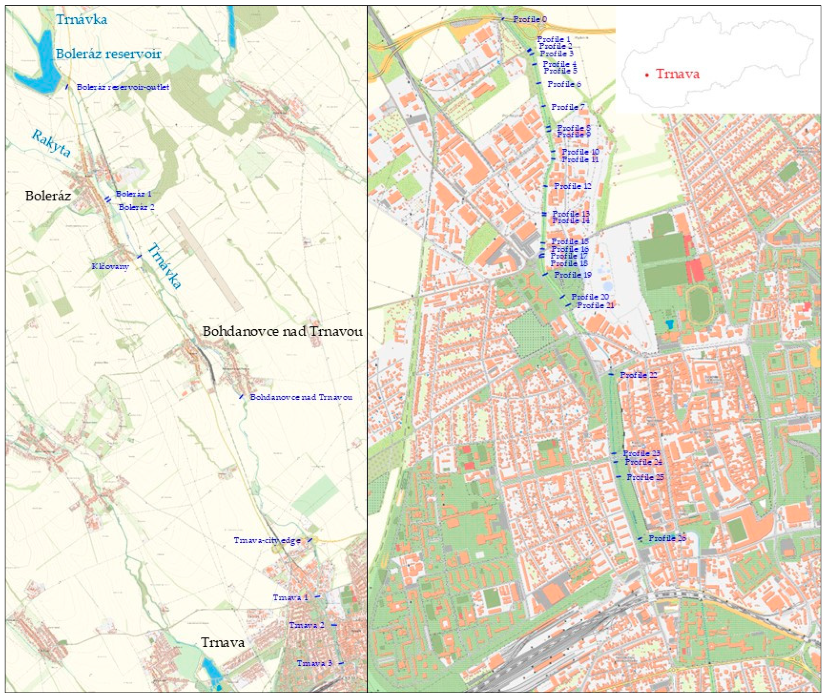
2.1. Field Measurements

The purpose of the field measurements was to obtain a geodetic survey of the riverbed and the hydraulic parameters of the watercourse in which the proposed water retention measures will be implemented. The measurements were carried out in two stages.
The first stage of field measurements was carried out during the winter period when the water levels were relatively low. They concentrated on obtaining the topographic and elevation data (cross-section profiles, longitudinal profiles), the location of the outlets of CSO chambers, bridges, and other objects located in the riverbed or above it (Figure 3). Using a GPS device and a Universal Measuring Station (the tachymetric measurements were carried out using a Leica TS02 (Heerbrugg, Switzerland) total station, while the coordinates of the base points were determined with a Leica Viva GS15 GNSS RTK (Heerbrugg, Switzerland) receiver with Leica CS15 (Heerbrugg, Switzerland) controller in the Slovak reference coordinate and height system S-JTSK and Bpv), 27 cross-section profiles (profiles 0–26) of the riverbed, 5 profiles of the bridges, and 29 outlets were located and measured, which were later used in the numerical model design.
The aim of the second stage, carried out in late winter–early spring, was to obtain data for the calibration of the numerical model and to measure geodetic points to supplement the geometry of the model. Two additional cross-section profiles and water levels in the Trnávka River were measured. The flow rate was also measured using the Flo-Mate device [34]. Higher water levels are required for reliable calibration of the numerical model; therefore, the flow rate was measured only in the second stage, when, due to precipitation, higher flow rates occurred than in the first stage. The Flo-Mate measures point velocities, from which the actual flow rate Q = 330 L.s−1 was later determined. For comparison, the minimal discharge under the Boleráz reservoir is, according to the handling regulations [35], 150 L.s−1 in an average year and 44 L.s−1 in a dry year. The maximum discharge under the Boleráz reservoir is set at 36 m3.s−1, which corresponds to the 100-year flood flow rate Q100.
This stage was essential for the calibration of the numerical model, where Manning’s roughness coefficient as the main calibration parameter was adjusted in a way so that the computed water level fits the measured values of the water level in Trnávka River.
In addition to field measurements, the purpose of which was to determine the above-described data, a chemical–physical study of the watercourse took place along the second stage of field measurements, in late winter–early spring, and was carried out in order to determine whether the Trnávka River is chemically polluted or not.
Water and sediment samples were taken directly from the Trnávka River at pre-specified profiles, selected regarding anthropogenic activity along the river (not only in the city of Trnava, but also in the upper reaches of the Trnávka River) and the locations of CSO chamber outlets. The location of individual measurement profiles can be seen in Figure 3. The focus was on the occurrence of the following indicators: pH, conductivity, concentration of dissolved oxygen, and concentration of NH4+, Cu, SO42−.
The water samples were collected into standard 0.5 L sampling bottles by professionally qualified personnel authorized to perform this type of sampling. Immediately after sampling, the bottles were cooled to 6 °C and transported to the laboratory, where the analyses were performed without delay. The laboratory analyses included the determination of pH, electrical conductivity (EC), and dissolved oxygen (DO). These parameters were selected due to their significance in the assessment of surface water quality:
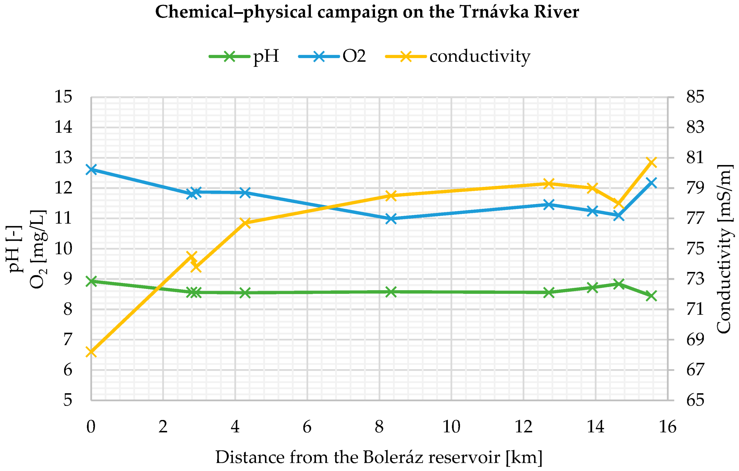
  • pH indicates the acidity or alkalinity of water, which affects biological processes and the solubility of substances.
  • Electrical conductivity reflects the concentration of dissolved ionic substances, often associated with anthropogenic pollution.
  • Dissolved oxygen is essential for the survival of aquatic life and is a key indicator of aerobic or anaerobic conditions in the water body.
The analyses were conducted at the Laboratory of the Department of Sanitary and Environmental Engineering, Faculty of Civil Engineering, Slovak University of Technology in Bratislava, using the Hach HQ40D (Loveland, CO, USA) portable multimeter.
The current values of chemical–physical properties of the water can be measured and compared with defined limit values, and the degree of deviation from natural conditions can be determined accurately. However, chemical–physical analyses only record the current situation in the watercourse. They do not express the long-term state of the watercourse, nor can the conclusions about the previous events be made.

2.2. Design of the Numerical Model

The design of the numerical model followed the modeling protocol described in [36]:
  • Establish the purpose of the model, which determines the use of appropriate mathematical equations and appropriate software for solving the given task. As already mentioned, HEC-RAS software was selected for the design of the 1D numerical model of the Trnávka River. HEC-RAS offers several advantages, one of which is free availability. Others are user-friendly interface and data management, and more importantly, its integration with GIS. Equations used in HEC-RAS are described in [33];
  • Develop a conceptual model of the system based on all available data in order to obtain the natural conditions of the studied area. During this phase, the geodetic survey of the Trnávka River was conducted, as already described above;
  • Model design—the conceptual model is adjusted into a form suitable for modeling. Boundary conditions are set, and preliminary values for calibration parameters are selected;
  • Calibration with the purpose of establishing that the model can reproduce field-measured data—data measured during the second stage of the field measurements. Calibration of the Trnávka numerical model was conducted by trial-and-error adjustment of the calibration parameter, which was the value of Manning’s roughness coefficient (presented in Table 1).
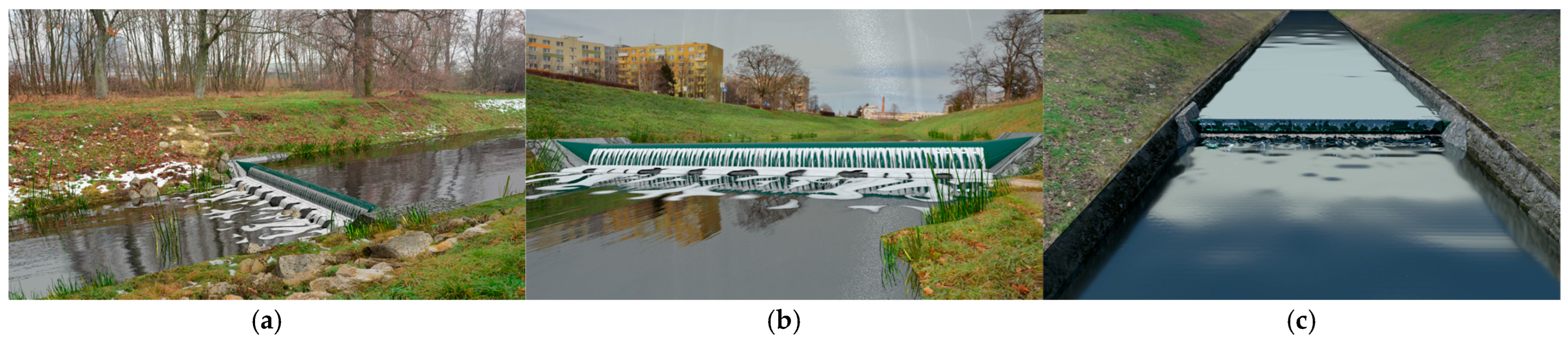
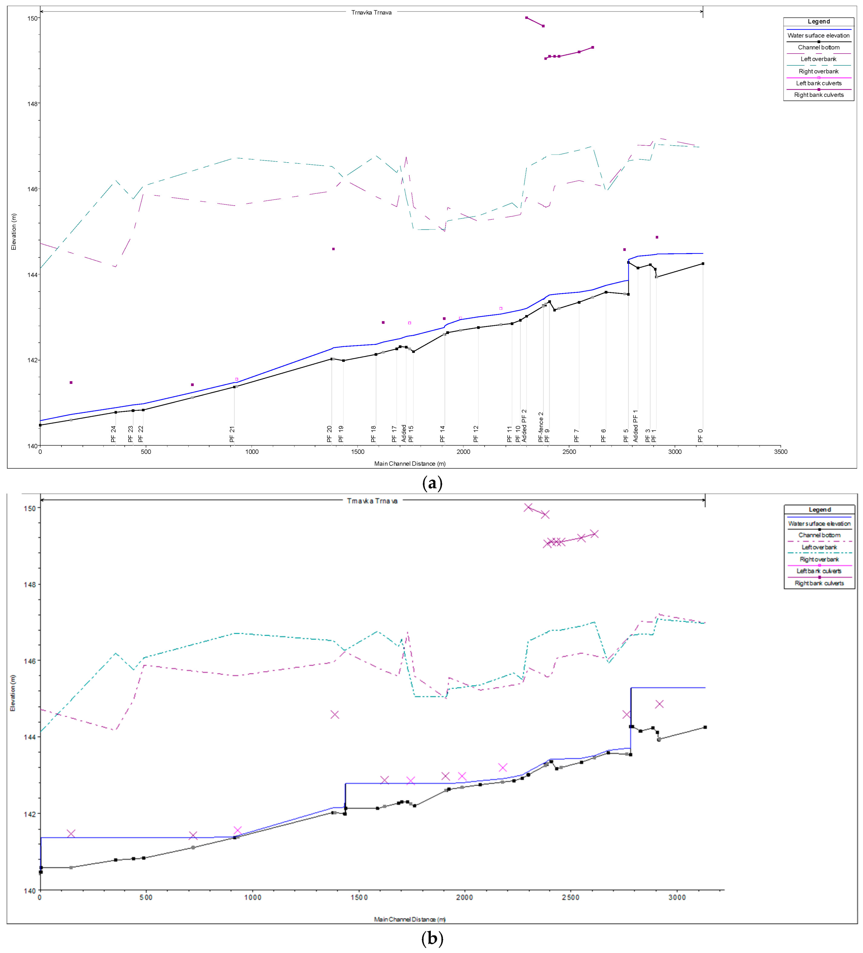
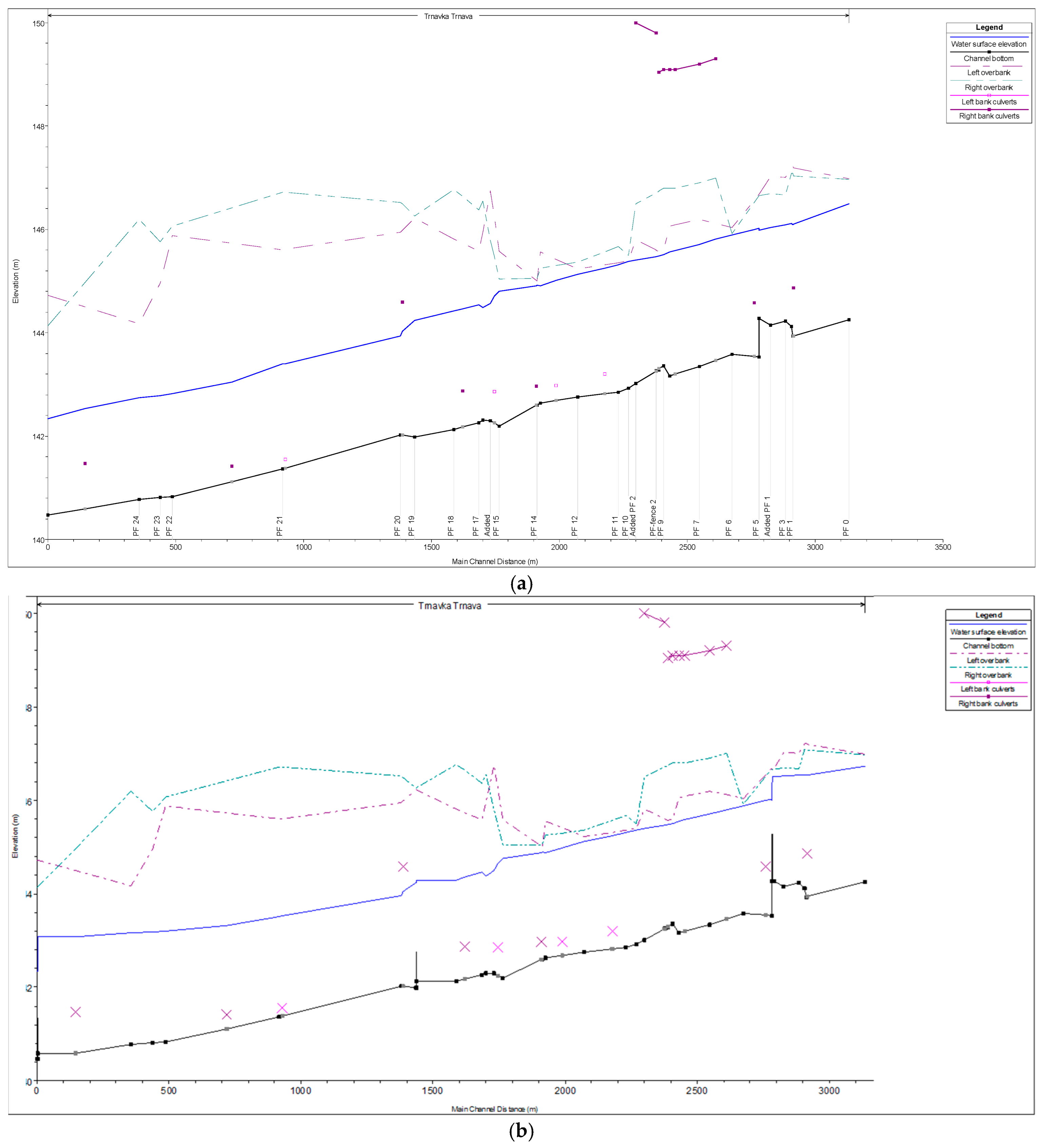
  • Prediction—response of the system to future events. The model is run with calibrated values, except for those that are expected to change in the future – construction of three inflatable rubber weirs (Figure 4).
The calibrated numerical model of the Trnávka River was used for simulations of the water level regime in the range from the minimum biological flow Qmin,bio = 44.0 L.s−1 (Figure 5a, which shows that smaller water depths were achieved mainly in the lower part of the watercourse, where the riverbed is wider, regulated, and has a prismatic character) to the flood wave Q100 = 36.0 m3.s−1 (Figure 5a, which shows that the most critical sections in the assessed part of the Trnávka River occurred in the upper part of the watercourse, where the riverbed is non-prismatic), which represents the values of the discharge under the Boleráz reservoir. The length of the modeled section is 3062 m. The watercourse was stationed by relative stationing (relative km), i.e., a stationing that does not correspond to the stationing of the watercourse in river kilometers (rkm). The relative kilometer 0.000 was set to the location of the last measured cross-section in Bernolák city park before inflow into the underground pipeline.

3. Results

3.1. Numerical Modeling

The final design of water retention measures on the Trnávka River consisted of three inflatable rubber weirs located in selected profiles appropriate for the design itself and for the construction process and future maintenance as well:
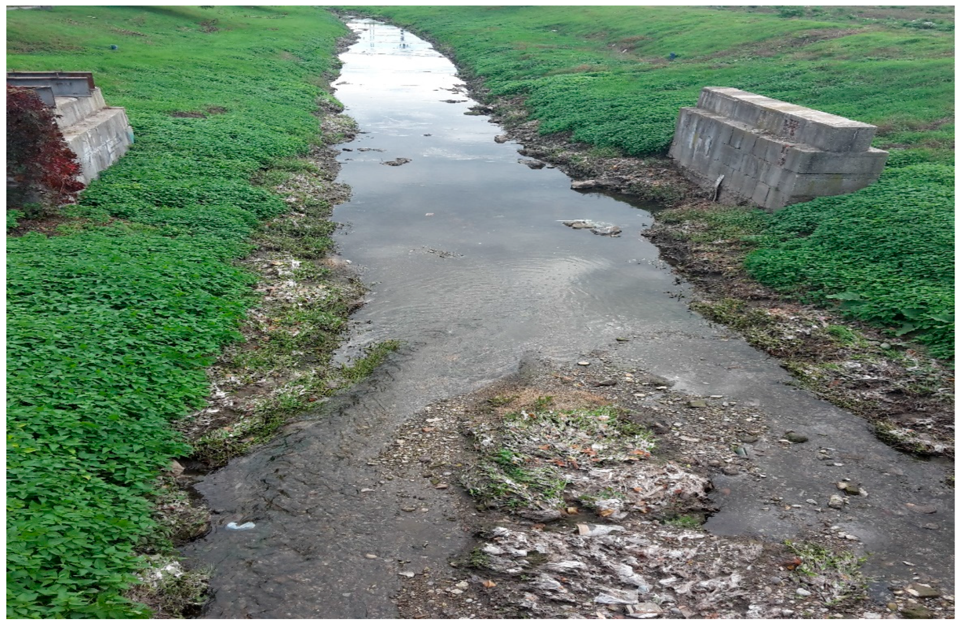
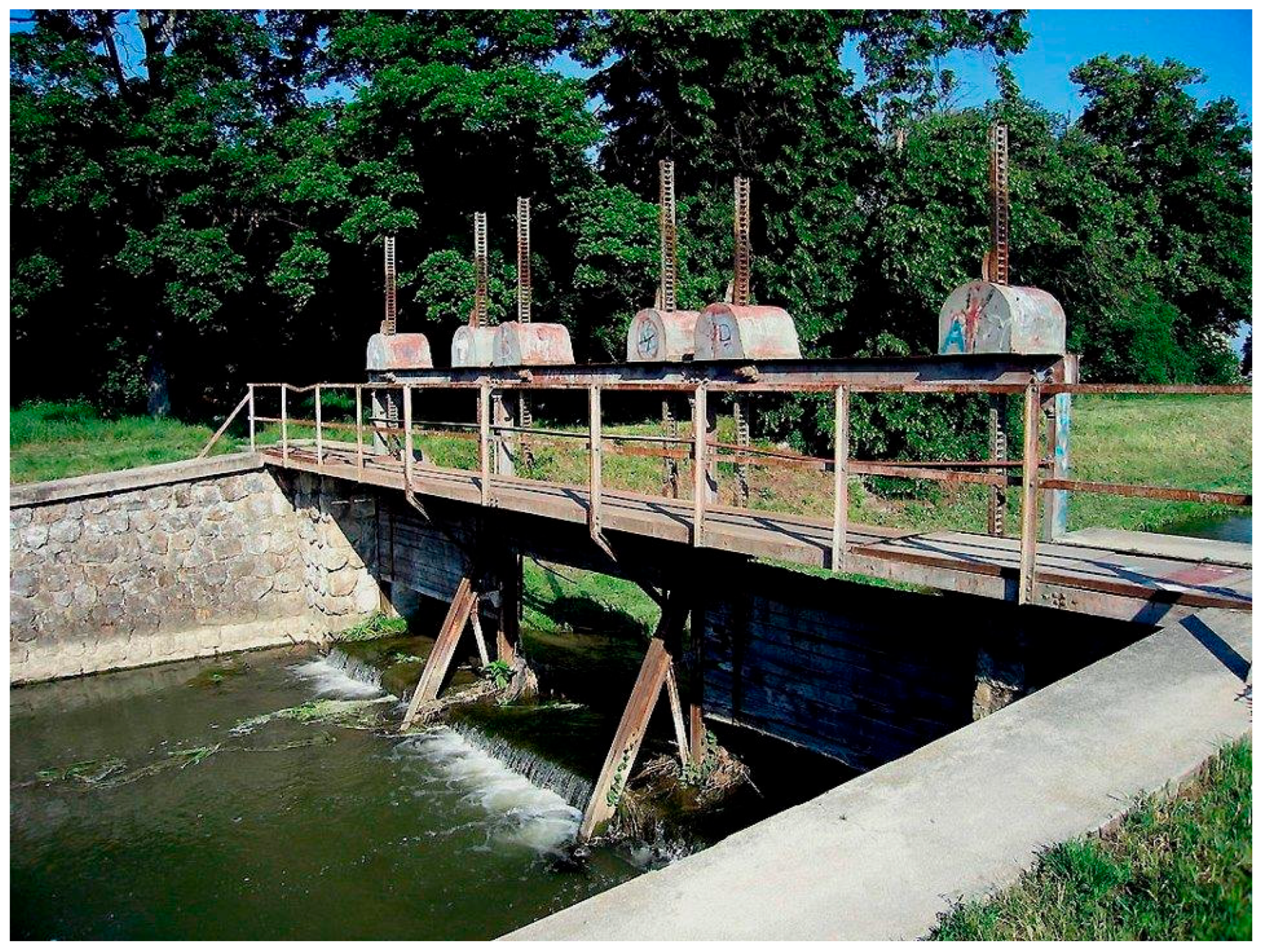
  • The first one was proposed for the profile at a relative km 2.754, locality Štrky (Figure 4a)—the profile of the previously removed sluice gate (Figure 2), where it is possible to use the already existing substructure. The height of the weir is 1.0 m, which corresponds to the height of the removed sluice gate;
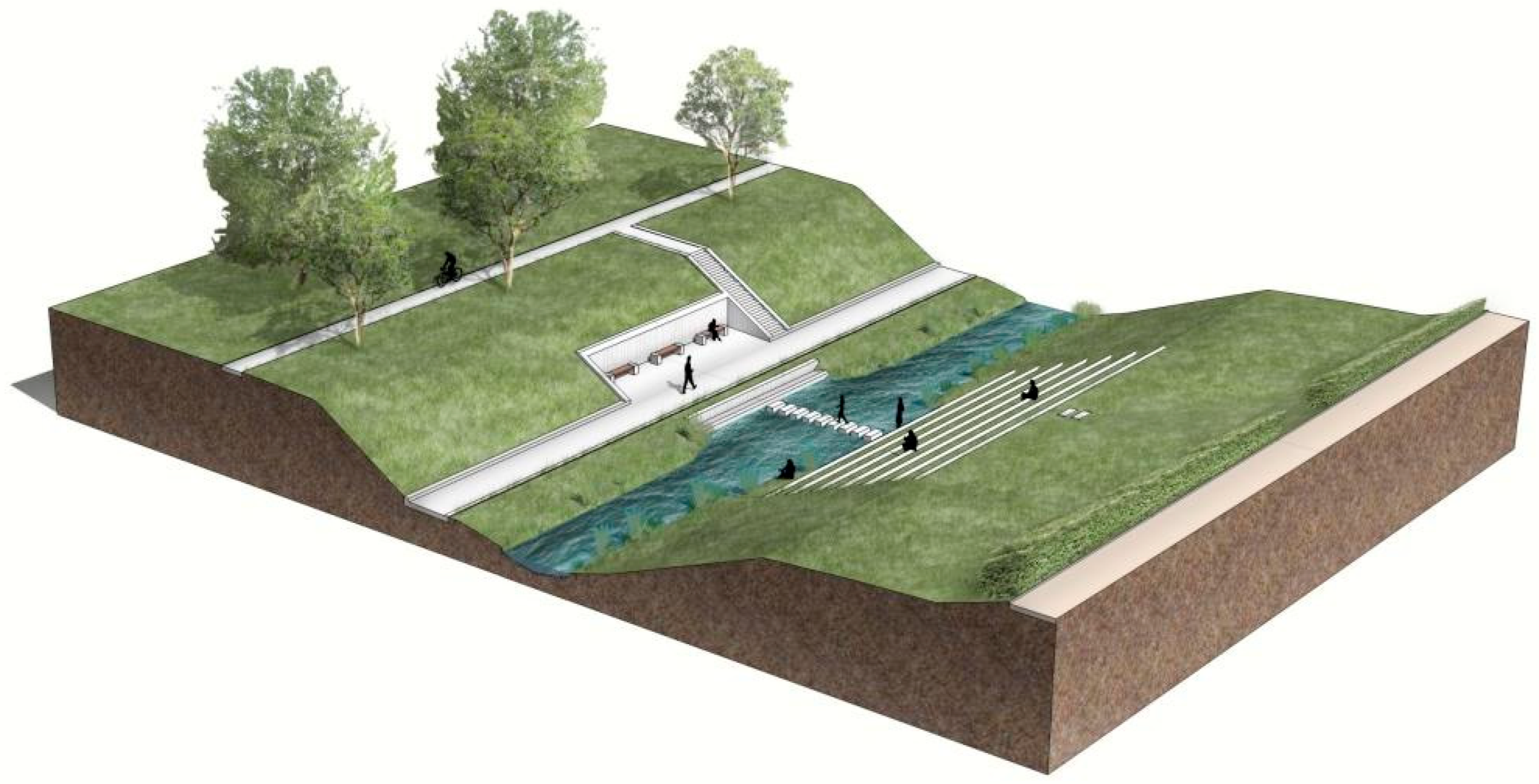
  • The second (Weir Calvary) was designed at the relative km 1.433 near a park (Figure 4b) where a panel access road descends, allowing easy access for construction equipment to the construction site and later for maintenance (as it was their original purpose). This lower structure will create a backwater level directly in the city and thus complete the park environment with a more prominent water element. The maximum height was designed at 0.6 m;
  • The third weir can be located near the Monument to the Victims of World War I at a relative km 0.0005 (Figure 4c). Its maximum height was designed to be 0.75 m. The structure would make the adjacent park area more attractive, and together with the previously mentioned two weirs, it can create a cascade of hydraulic structures on the Trnávka River.
The inflatable rubber weirs are rubber textile bags attached to the substructure and pillars. The bags can be filled with water or air. The amount of water falling through the bag is regulated by the height of the bag. The height of the bag depends on the amount of water or air in the bag [37]. The reason for choosing this type of structure was its main advantages—the construction is simpler in comparison with traditional types, meaning the installation is also simpler, and their price, which is lower compared to other types. These types can be fully automatic (even in flood events when the bag empties itself automatically and thus poses minimal resistance to flowing water), which is convenient in an urban area.
The effect of the proposed inflatable rubber weirs on the water level in the Trnávka River during the minimal biological flow, as well as during the maximal flow rate during a flood situation, can be seen in Figure 5b and Figure 6b, respectively.

3.2. The Results of the Chemical–Physical Measurement Campaign

The results of the measurements of pH level, conductivity and dissolved oxygen concentration are summarized in Table 2 and Figure 7. The pH level slightly increased in the Trnava urban area, which should have been caused by the anthropogenic activity, but did not exceed the level of toxicity for surface water (pH from 6 to 9). Also, the increasing conductivity indicated an increasing amount of contamination in the watercourse, which, unfortunately, could not be directly linked with the source of pollution or its origin. The concentration of dissolved oxygen decreased with the downstream decreasing stage of aeration from the Boleráz reservoir, with the exception of the last sampling point located near the piped section of the Trnávka River. The minimum concentration (5 mg/L) was not reached, though.
The concentrations of NH4+ (measured with the accuracy of 10 mg/L), sulfates SO42− (measured with the accuracy of 200 mg/L) and Cu1+/2+ (measured with the accuracy of 10 mg/L) were not detected in any of the water and sediment samples.

4. Discussion

As was already stated, three rubber weirs were proposed on the Trnávka River, and the impact of the backwater on the functionality of the CSO chambers of the sewer network in the city of Trnava and on the transition of the flood flow rate Q100 was assessed. The numerical model of the current state was created, simulating the water level in the Trnávka River from the minimal biological flow rate to the maximal flow rate Q100. During normal flow rates, the water level is below the outlets of the CSO chambers. Even though the outlets of the CSO chambers are flooded during flood flow rates, the overflow weirs of the CSO chambers are relatively high and prevent flooding of the sewer system.
The prediction—simulation with the addition of the proposed inflatable rubber weirs—confirmed that flooding of most of the outlets of the CSO chambers would not occur at the minimum biological flow rate (Figure 5b). The height of the weirs was dimensioned so that at the average flow rate flowing through the riverbed during the year, which was set at 200 L.s−1, flooding of the sewerage network outlets would not occur.
The simulation of the flood flow rate Q100 = 36 m3.s−1 (Figure 6b) showed that, despite the fact that almost all the outlets were flooded (as it was also in the simulation of the current state), the transition of the flood passed in the riverbed, not causing the flooding of the adjacent area (which was also one of the requirement for the design). However, from a safety point of view, the inflatable rubber weirs should be deflated during times of increased flow rates, so that the height would almost reach the original height, i.e., the height without the hydraulic structures.
From the results of the analysis of the samples taken along the Trnávka River, it was clear that not a single indicator exceeded the limit value within the laboratory accuracy. The same results were obtained by [25] during his research in the same locality. For a more accurate analysis, a long-term survey of the impact of anthropogenic activity on water quality is necessary, especially during the summer months at low flow rates. Nevertheless, considering the time horizon of the measurement campaign, which took place at the beginning of February at an increased flow rate, it can be stated that construction of the proposed measures (inflatable rubber weirs) which will allow the regular ‘flushing’ of the riverbed (by increasing the flow velocity and flow rate) can contribute to the purity of the watercourse in the city of Trnava.
Moreover, as already mentioned, the new water elements can make public places more attractive, which is also confirmed by several studies ordered by the city of Trnava, one of which can be seen in Figure 8.

5. Conclusions

This study, which was part of the pilot cooperation project between the Slovak University of Technology in Bratislava and the city of Trnava, Slovakia, proposes and verifies the proposal of water retention measures—three inflatable rubber weirs—on the Trnávka River in the urban area of the city of Trnava, Slovakia, which will also serve as a remediation technique for CSO-affected watercourses. The main contribution of the proposed weirs is to the ‘flushing’ of the riverbed after heavy rainfall, thus increasing the purity of the watercourse.
To our knowledge, it is the first time that water retention measures were introduced as a remediation technique for the treatment of the CSO-affected watercourses. The design of the proposed measures was verified using a modern numerical modelling method based on the updated geodetic survey conducted in the area of interest. The main purpose of the simulations performed in the HEC-RAS software was to exclude the adverse effect of the backwater on the functioning of the CSO chambers in Trnava, which was secured by designing their height for the average flow rate in the Trnávka River, and to ensure the transition of the flood wave. The simulation of the flood flow rate Q100 showed that, even though almost all the outlets of the CSO chambers were flooded (as was also in the simulation of the current state), the transition of the flood passed in the riverbed, not causing the flooding of the adjacent area. However, from a safety point of view, the inflatable rubber weirs should be deflated during times of increased flow rates, so that the height would almost reach the original height, i.e., the height without the hydraulic structures.
In addition to field measurements concentrating on a geodetic survey of the location of interest and velocity measurements, a chemical–physical study of the watercourse was carried out during higher water levels to determine whether the Trnávka River is chemically polluted or not. Water and sediment samples were taken directly from the Trnávka River in pre-specified profiles, the locations of which were chosen regarding anthropogenic activity located not only in the city of Trnava, but also in the upper reaches of the Trnávka River along with the outlets of the CSO chambers. From the results of the analysis of the samples, it was clear that not a single indicator exceeded the limit value within the laboratory accuracy, meaning that during higher flow rates, the Trnávka River can be considered clean, which confirms that the design can be successful in dealing with the CSO-polluted watercourse.
The proposal of inflatable rubber weirs on the Trnávka River serves as an example of sustainable urban water management, taking advantage of the benefits of water retention measures, which can provide multiple benefits for the protection and management of water resources. By mitigating the impact of CSOs, the project aims to improve the water quality, thereby protecting the river flowing through the urban area and its ecosystem. Furthermore, the proposal enhances the added value of the river within the urban area, making it an attractive public place. The proposed measures not only address a critical environmental challenge that CSOs represent but also offer a solution for other CSO-affected watercourses.
As was already stated, it is the pilot project that can be built up in the future, concentrating more, e.g., on the coupled hydrodynamic water quality models and thus validating the measures’ proposal, and the results of which can then be transferred and verified in practice.

Author Contributions

Conceptualization, M.Č. and J.M.; methodology, M.Č., A.Š., J.H. and R.H.; software, J.M. and M.O.; validation, M.Č., J.M., J.H. and R.H.; formal analysis, M.Č. and A.Š.; investigation, M.Č., J.M., J.H., R.W. and R.H.; resources, A.Š. and P.Š.; data curation, J.M., J.H. and R.H.; writing—original draft preparation, M.Č.; writing—review and editing, P.Š., J.H. and R.H.; visualization, M.O. and P.Š.; supervision, A.Š.; project administration, A.Š. and P.Š.; funding acquisition, A.Š. and P.Š. All authors have read and agreed to the published version of the manuscript.

Funding

This research was funded by the VEGA project No. 1/0161/24 Research utilization an artificial intelligence methods in the management of multipurpose water-management systems.

Institutional Review Board Statement

Not applicable.

Informed Consent Statement

Not applicable.

Data Availability Statement

The data obtained from the chemical–physical study of the water and sediments of the Trnávka River are presented in this paper. The data obtained from geodetic survey and measurements of the flow velocities are available upon request to the authors.

Acknowledgments

This research was funded by the VEGA project No. 1/0161/24 Research utilization an artificial intelligence methods in the management of multipurpose water-management systems.

Conflicts of Interest

The authors declare no conflicts of interest.

References

  1. US Environmental Protection Agency. Combined Sewer Overflow Basics. Available online: https://www.epa.gov/npdes/combined-sewer-overflow-basics (accessed on 8 January 2025).
  2. Butler, D.; Digman, C.; Makropoulos, C.; Davies, J.W. Urban Drainage, 5th ed.; CRC Press: Boca Raton, FL, USA, 2024; ISBN 978-1-003-40863-5. [Google Scholar]
  3. Combined Sewer Overflows Explained. Available online: https://environmentagency.blog.gov.uk/2020/07/02/combined-sewer-overflows-explained/ (accessed on 8 January 2025).
  4. Botturi, A.; Ozbayram, E.G.; Tondera, K.; Gilbert, N.I.; Rouault, P.; Caradot, N.; Gutierrez, O.; Daneshgar, S.; Frison, N.; Akyol, Ç.; et al. Combined Sewer Overflows: A Critical Review on Best Practice and Innovative Solutions to Mitigate Impacts on Environment and Human Health. Crit. Rev. Environ. Sci. Technol. 2021, 51, 1585–1618. [Google Scholar] [CrossRef]
  5. Reyes-Silva, J.; Bangura, E.; Helm, B.; Benisch, J.; Krebs, P. The Role of Sewer Network Structure on the Occurrence and Magnitude of Combined Sewer Overflows (CSOs). Water 2020, 12, 2675. [Google Scholar] [CrossRef]
  6. Jung, Y.E.; Jeong, M.M.; Jun, H.; Smith, T. Contemplation of Improvement Efforts to Manage Combined Sewer Overflows. Infrastructures 2023, 8, 150. [Google Scholar] [CrossRef]
  7. Sokáč, M.; Bara, M.K.; Velísková, Y.; Sočuvka, V. Rainfall Data in Urban Drainage: What Do We Need? Acta Hydrol. Slovaca 2025, 26, 132–143. [Google Scholar]
  8. Muttil, N.; Nasrin, T.; Sharma, A.K. Impacts of Extreme Rainfalls on Sewer Overflows and WSUD-Based Mitigation Strategies: A Review. Water 2023, 15, 429. [Google Scholar] [CrossRef]
  9. US EPA. R. 01 Soak Up the Rain: The Benefits of Green Infrastructure. Available online: https://www.epa.gov/soakuptherain/soak-rain-benefits-green-infrastructure (accessed on 16 January 2025).
  10. Fletcher, T.D.; Shuster, W.; Hunt, W.F.; Ashley, R.; Butler, D.; Arthur, S.; Trowsdale, S.; Barraud, S.; Semadeni-Davies, A.; Bertrand-Krajewski, J.-L.; et al. SUDS, LID, BMPs, WSUD and More—The Evolution and Application of Terminology Surrounding Urban Drainage. Urban Water J. 2015, 12, 525–542. [Google Scholar] [CrossRef]
  11. Eckart, K.; McPhee, Z.; Bolisetti, T. Performance and Implementation of Low Impact Development—A Review. Sci. Total Environ. 2017, 607–608, 413–432. [Google Scholar] [CrossRef]
  12. Riechel, M.; Matzinger, A.; Pallasch, M.; Joswig, K.; Pawlowsky-Reusing, E.; Hinkelmann, R.; Rouault, P. Sustainable Urban Drainage Systems in Established City Developments: Modelling the Potential for CSO Reduction and River Impact Mitigation. J. Environ. Manag. 2020, 274, 111207. [Google Scholar] [CrossRef]
  13. Hoban, A. Water Sensitive Urban Design Approaches and Their Description. In Approaches to Water Sensitive Urban Design; Elsevier: Amsterdam, The Netherlands, 2019; pp. 25–47. ISBN 978-0-12-812843-5. [Google Scholar]
  14. Mustafa, M.; Zhou, J.; Alyaseri, I. Effect of Rainfall Intensity on Stormwater Reduction in Combined Sewers from the Impact of Permeable Pavements. In Proceedings of the World Environmental and Water Resources Congress, Sacramento, CA, USA, 21–25 May 2017; American Society of Civil Engineers: Sacramento, CA, USA, 2017; pp. 383–390. [Google Scholar]
  15. Llopart-Mascaró, A.; Farreny, R.; Gabarrell, X.; Rieradevall, J.; Gil, A.; Martínez, M.; Puertas, J.; Suárez, J.; Río, H.D.; Paraira, M. Storm Tank against Combined Sewer Overflow: Operation Strategies to Minimise Discharges Impact to Receiving Waters. Urban Water J. 2015, 12, 219–228. [Google Scholar] [CrossRef]
  16. Martino, G.D.; De Paola, F.; Fontana, N.; Marini, G.; Ranucci, A. Pollution Reduction in Receivers: Storm-Water Tanks. J. Urban Plan. Dev. 2011, 137, 29–38. [Google Scholar] [CrossRef]
  17. Azurix North America; Stirrup, M.; Marchant, D. New City of Hamilton, Water Quality. Simulation of a Combined Sewer Overflow Storage Tank. J. Water Manag. Model. 2002, 10, 271–287. [Google Scholar] [CrossRef]
  18. Casal-Campos, A.; Fu, G.; Butler, D.; Moore, A. An Integrated Environmental Assessment of Green and Gray Infrastructure Strategies for Robust Decision Making. Environ. Sci. Technol. 2015, 49, 8307–8314. [Google Scholar] [CrossRef] [PubMed]
  19. Casal-Campos, A.; Sadr, S.M.K.; Fu, G.; Butler, D. Reliable, Resilient and Sustainable Urban Drainage Systems: An Analysis of Robustness under Deep Uncertainty. Environ. Sci. Technol. 2018, 52, 9008–9021. [Google Scholar] [CrossRef] [PubMed]
  20. Sokáč, M.; Velísková, Y.; Koczka Bara, M. Effect Evaluation of Different Adaptation Measures Applied on Urban Catchment. In Proceedings of the Symposium Proceedings, Štrbské Pleso, Slovakia, 10 September 2024; Spektrum STU Publishing: Štrbské Pleso, Slovakia, 2024; pp. 453–461. [Google Scholar]
  21. Rizzo, A.; Tondera, K.; Pálfy, T.G.; Dittmer, U.; Meyer, D.; Schreiber, C.; Zacharias, N.; Ruppelt, J.P.; Esser, D.; Molle, P.; et al. Constructed Wetlands for Combined Sewer Overflow Treatment: A State-of-the-Art Review. Sci. Total Environ. 2020, 727, 138618. [Google Scholar] [CrossRef] [PubMed]
  22. Tao, W.; Bays, J.; Meyer, D.; Smardon, R.; Levy, Z. Constructed Wetlands for Treatment of Combined Sewer Overflow in the US: A Review of Design Challenges and Application Status. Water 2014, 6, 3362–3385. [Google Scholar] [CrossRef]
  23. Masi, F.; Rizzo, A.; Bresciani, R.; Conte, G. Constructed Wetlands for Combined Sewer Overflow Treatment: Ecosystem Services at Gorla Maggiore, Italy. Ecol. Eng. 2017, 98, 427–438. [Google Scholar] [CrossRef]
  24. Palermo, M.; Hays, D.F. Sediment Dredging, Treatment and Disposal. In Processes, Assessment and Remediation of Contaminated Sediments; Reible, D.D., Ed.; SERDP/ESTCP Environmental Remediation Technology; Springer: New York, NY, USA, 2014; Volume 6, pp. 365–391. ISBN 978-1-4614-6725-0. [Google Scholar]
  25. Portnov, M.; Hrudka, J.; Wittmanová, R.; Ilavská, J.; Stanko, Š. Monitoring the Quality of Overflowed Waters in Slovakia. Pollack Period. 2024. published online ahead of print. [Google Scholar] [CrossRef]
  26. Naz, A.; Chowdhury, A.; Mishra, B.K. Applications of Microbes in Bioremediation of Point Source Pollutants from Wastewater. IOP Conf. Ser. Earth Environ. Sci. 2021, 796, 012039. [Google Scholar] [CrossRef]
  27. Shah, N.; Marulanda, D.; DeLorenzo, R.; De Rugeris, J.; Staniec, T. CSO Sediment Removal in an Urban Tributary. In Proceedings of the Western Dredging Association (WEDA XXXII) Technical Conference and Texas A&M University (TAMU 43) Dredging Seminar, San Antonio, TX, USA, 10 June 2012. [Google Scholar]
  28. Yan, J.; Li, F. Effects of Sediment Dredging on Freshwater System: A Comprehensive Review. Environ. Sci. Pollut. Res. 2023, 30, 119612–119626. [Google Scholar] [CrossRef]
  29. European Commission. Directorate General for the Environment. EU Policy Document on Natural Water Retention Measures: By the Drafting Team of the WFD CIS Working Group Programme of Measures (WG PoM); Publications Office: Luxembourg, 2014. [Google Scholar]
  30. Zeleňáková, M.; Diaconu, D.C.; Haarstad, K. Urban Water Retention Measures. Procedia Eng. 2017, 190, 419–426. [Google Scholar] [CrossRef]
  31. Spatial Plan of the City of Trnava; EKOPOLIS—Ateliér Architektúry, Urbanizmu a Územného Plánovania: Bratislava, Slovakia, 2010; p. 233. (In Slovak)
  32. Hegyi, L.; Miterková, I.; Schvalb, M.; Šteiner, A. Trnava Adaptation Strategy on the Impacts of Climate Change—Waves of Heat; KRI: Košice, Slovakia, 2015; p. 104. [Google Scholar]
  33. Brunner, G.W. HEC-RAS River Analysis System. Hydraulic Reference Manual. Version 5.0; US Army Corps of Engineers, Hydrologic Engineering Center (HEC): Davis, CA, USA, 2016. [Google Scholar]
  34. Marsh-McBirney, Inc. FLO-MATE. Model 2000 Portable Flowmeter Instruction Manual; Marsh-McBirney, Inc.: Frederick, MD, USA, 1990. [Google Scholar]
  35. SVP. OZ Piešťany, TBD Department. Handling Regulations of Boleráz Hydraulic Structure (Reservoir on the Trnávka River in rkm 27,350); SVP: Piešťany, Slovakia, 2006. (In Slovak) [Google Scholar]
  36. Květon, R.; Orfánus, M. Hydroinformatics 1st Part. Simulation of Surface Water Flow Processes in Open Channels and Through Hydraulic Structures; Slovak University of Technology in Bratislava: Bratislava, Slovakia, 2015; ISBN 978-80-227-4468-3. (In Slovak) [Google Scholar]
  37. Šulek, P. Weirs; Spektrum STU Publishing: Bratislava, Slovakia, 2023; ISBN 978-80-227-5381-4. (In Slovak) [Google Scholar]
Figure 1. The Trnávka River after a heavy rainstorm—remains of visible solid matter from sanitary overflows and other solid waste.
Sustainability 17 06280 g001
Figure 2. Sluice gate on the Trnávka River (removed in 2013 due to its state of disrepair).
Sustainability 17 06280 g002
Figure 3. Left side: Location of chemical–physical measurement campaign’s profiles upstream of the city of Trnava (profile names along the watercourse: Boleráz reservoir outlet, Boleráz 1, Boleráz 2, Klčovany, Bohdanovce nad Trnavou; Trnava city edge, Trnava 1, Trnava 2, and Trnava 3). Right side: Map of the Trnávka River in the city of Trnava with the measured profiles (below the last measured profile, the flow passes through a piped section under the city and later flows again on the surface in a riverbed).
Sustainability 17 06280 g003
Figure 4. The visualization of the three inflatable rubber weirs on the Trnávka River: (a) at a relative km 2.754, locality Štrky—outside the Trnava urban area; (b) at a relative km 1.433, Park near a Calvary—Trnava urban area; (c) at a relative km 0.0005—Trnava urban area.
Sustainability 17 06280 g004
Figure 5. The simulated water level in the Trnávka River during the minimal biological flow rate: (a) current state; (b) prediction.
Sustainability 17 06280 g005
Figure 6. The simulated water level in the Trnávka River during the maximal flow rate Q100: (a) current state; (b) prediction.
Sustainability 17 06280 g006
Figure 7. The measured values of pH, conductivity, and dissolved oxygen along the Trnávka River.
Sustainability 17 06280 g007
Figure 8. Promenade design in Trnava (source: Fontes Brno, Czech Republic).
Sustainability 17 06280 g008
Table 1. The calibrated Manning’s roughness coefficient for the Trnávka River in the city of Trnava.
Manning’s Roughness Coefficient
Relative kmRiver BottomRiverbank
0.000–1.379 10.010 (concrete blocks)0.020 (concrete blocks)
1.379 1–3.0620.020 (stone fortification)0.030 (short grass)
1 In relative km 1.379, the material used for the river bottom and riverbank changes.
Table 2. The measured values of pH, conductivity, and dissolved oxygen along the Trnávka River.
LocalitypHConductivity σ
[mS/m]
Dissolved Oxygen O2 [mg/L]
Boleráz reservoir—outlet8.9368.212.62
Boleráz 18.5774.511.81
Boleráz 28.5673.811.87
Klčovany8.5576.711.85
Bohdanovce and Trnavou8.5878.510.99
Trnava—city edge8.5679.311.46
Trnava 18.7279.011.25
Trnava 28.8478.011.10
Trnava 38.4580.712.18
Disclaimer/Publisher’s Note: The statements, opinions and data contained in all publications are solely those of the individual author(s) and contributor(s) and not of MDPI and/or the editor(s). MDPI and/or the editor(s) disclaim responsibility for any injury to people or property resulting from any ideas, methods, instructions or products referred to in the content.

