Article

Wildfire Severity Reduction Through Prescribed Burning in the Southeastern United States

by
C. Wade Ross
1,2,3,*,
E. Louise Loudermilk
2,
Steven A. Flanagan
2,
Grant Snitker
4,
J. Kevin Hiers
5 and
Joseph J. O’Brien
2
1
Tall Timbers, Tallahassee, FL 32312, USA
2
United States Department of Agriculture Forest Service, Southern Research Station, Athens, GA 30602, USA
3
First Street, 777 3rd Avenue, New York, NY 10017, USA
4
New Mexico Consortium, 800 Bradbury Dr SE, Suite 213, Albuquerque, NM 87106, USA
5
Natural Resources Institute, Texas A&M University, Washington, DC 20036, USA
*
Author to whom correspondence should be addressed.
Sustainability 2025, 17(13), 6230; https://doi.org/10.3390/su17136230
Submission received: 4 February 2025 / Revised: 8 June 2025 / Accepted: 9 June 2025 / Published: 7 July 2025

Abstract

With wildfires becoming more frequent and severe in fire-prone regions affected by warmer and drier climate conditions, reducing hazardous fuels is increasingly recognized as a preventative strategy for promoting sustainability and safeguarding valued resources. Prescribed fire is one of the most cost-effective methods for reducing hazardous fuels and hence wildfire severity, yet empirical research on its effectiveness at minimizing damage to highly valued resources and assets (HVRAs) remains limited. The overarching objective of this study was to evaluate wildfire severity under differing weather conditions across various HVRAs characterized by diverse land uses, vegetation types, and treatment histories. The findings from this study reveal that wildfire severity was generally lower in areas treated with prescribed fire, although the significance of this effect varied among HVRAs and diminished as post-treatment duration increased. The wildland–urban interface experienced the greatest initial reduction in wildfire severity following prescribed fire, but burn severity increased more rapidly over time relative to other HVRAs. Elevated drought conditions had a significant effect, increasing wildfire severity across all HVRAs. The implications of this study underscore the role of prescribed fire in promoting sustainable land management by reducing wildfire severity and safeguarding both natural and built environments, particularly in the expanding wildland–urban interface.

1. Introduction

Wildfire is a natural phenomenon that occurs with differing frequencies and intensities dependent on the biome and plays a crucial role in biodiversity and resource sustainability [1]. In regions characterized by hazardous fuel loads, elevated wildfire severity increases the risk of damage to highly valued resources and assets (HVRAs)—defined here as cultural, natural, or economic assets with significant importance or worth to communities, ecosystems, or industries [2,3]. The expected increases in drought conditions and potential subsequent increases in wildfire severity for many regions of the U.S. underscore the urgency of addressing escalating wildfire threats through enhanced resource and management strategies [4,5,6]. Such strategies are essential for mitigating the risk of high-severity wildfires and promoting long-term sustainability in wildfire-prone landscapes [7]. Furthermore, the expanding wildland–urban interface (WUI), where homes are interspersed with wildland vegetation, is leading to an increasing number of people being affected by wildfires [8]. As the potential for wildfire frequency, extent, and severity increases, there is widespread demand for effective mitigation strategies to protect lives, property, and natural resources [9].
Fuel reduction treatments are increasingly recognized as a cost-effective method for mitigating wildfire risk and severity [10,11,12]. Such treatments aim to reduce the amount of flammable vegetation in areas prone to wildfires, thereby decreasing the likelihood of severe fires and their potential impacts [13]. For example, the Inflation Reduction Act of 2022 and the 2021 Infrastructure Investment and Jobs Act allocated an additional USD 2.87 billion and USD 2.56 billion, respectively, for fuel reduction treatments [14,15]. In light of the millions of vegetated acres targeted by fuel reduction, it is imperative to understand its mitigation potential and long-term ecological consequences.
One of the most cost-effective fuel-reduction strategies for mitigating wildfire severity and subsequent impacts on valued resources is through the use of prescribed fire—the intentional and controlled application of fire to achieve specific land management objectives [16,17,18]. The use of prescribed fire as a management strategy is grounded in the recognition that numerous ecosystems naturally coexist with fire, playing a critical role in shaping ecosystem structure and function [19,20]. These ecosystems are often described as being either fire-dependent or fire-adapted, highlighting their reliance on frequent fires to maintain ecological balance and health. By reintroducing fire in a controlled manner to reduce hazardous fuel loads, land managers can promote sustainability by reducing the risk of severe wildfires, improving wildlife habitat, and enriching biodiversity [21].
Although prescribed fire usage has increased substantially in recent decades, particularly in the southern U.S., where it functions as an important land management tool with over 50,000 treatments annually, the body of quantitative research assessing its effectiveness in mitigating wildfire severity to valued resources is relatively limited [22,23,24]. The scarcity of such studies is partly due to logistical constraints associated with conducting prescribed fire for research purposes, limited availability of spatially explicit prescribed fire data, and the inherent challenges of studying wildfires, which rely on opportunistic data collection rather than controlled experiments. Additionally, the unpredictable nature of wildfire ignitions makes it difficult to isolate the effects of prescribed fire on wildfire behavior and severity through empirical studies alone [25].
The utilization of remote sensing data, such as the Normalized Burn Ratio (NBR) index, offers a valuable and cost-effective tool for assessing wildfire severity and evaluating the effectiveness of prescribed fire treatments [26]. Remote sensing enables the analysis of large areas, providing a practical alternative to the intensive labor and financial resources required for field-based investigations [27]. The formula for calculating NBR is similar to the Normalized Difference Vegetation Index (NDVI), but NBR combines the use of both near-infrared (NIR) and shortwave-infrared (SWIR) wavelengths to discriminate between green, dry-senesced, and charred vegetation or soil [28]. Subsequent research has demonstrated that burn severity assessments can be enhanced through the use of the differenced Normalized Burn Ratio (dNBR), which is calculated by differencing pre-fire and post-fire NBR indices [29,30]. By accounting for pre- and post-fire conditions, dNBR provides an estimate of burn severity, with higher values indicating more intense fire effects.
In a recent study, Ross et al. [31] utilized the 2017 West Mims wildfire as a case study to assess Landsat-derived dNBR measurements of wildfire severity across ecosystems with varying management histories within the Okefenokee National Wildlife Refuge. Their findings revealed that on average, wildfire severity was reduced by 11% in areas that had undergone prescribed burning compared to those that had not. Notably, the timing of prescribed fires played a crucial role in determining their effectiveness. Specifically, areas treated with prescribed fire one month before the West Mims wildfire experienced an 80% reduction in burn severity. The study concluded that a prescribed fire frequency of 1 to 2 years has the largest mitigating effect. While these findings underscore the efficacy of prescribed fire as a tool for mitigating wildfire severity, they raise questions about the generalizability of these outcomes across different wildfire events, landscapes, and HVRAs. Consequently, this study aims to extend the analysis conducted by Ross et al. [31] on a larger scale, incorporating multiple wildfire incidents at a regional level to determine if the observed benefits of prescribed burning are consistent across diverse landscapes and HVRAs. This broader approach seeks to validate the role of prescribed fire as a key strategy in wildfire management and severity reduction.

2. Materials and Methods

Data processing and analyses were conducted in R [32], primarily utilizing functions from the packages tidyverse [33], sf [34], terra [35], and mgcv [36].

2.1. Study Site

Our analysis focused on Florida and Georgia, which together contribute roughly two-thirds of the annual nationwide acreage treated with prescribed fire [37]. Prescribed fire records for 11 National Wildlife Refuges (NWRs) were obtained by submitting a data request to the U.S. Fish and Wildlife Service (USFWS) Open Data (https://gis-fws.opendata.arcgis.com/, accessed on 12 January 2024). The dataset contained treatment records for Florida Panther, Lake Wales Ridge, Lake Woodruff, Merritt Island, Okefenokee, Piedmont, Savannah, St. Johns, St. Marks, St. Vincent, and Ten Thousand Islands NWRs (Figure 1). These records encompass both spatial and temporal details of prescribed fire perimeters and treatment dates across burn units, covering the period from 15 June 2013 to 29 June 2023. Consequently, our analysis was limited to this ten-year period. We calculated the duration of time between the treatment dates and the wildfire event dates in months, hereafter referred to as post-treatment duration or months since prescribed fire (MSRX), utilizing functions from the R lubridate package [38]. Following this, we converted the burn unit perimeters into raster format, employing the MSRX data to assign values to each raster cell to match the LANDFIRE resolution (30 m × 30 m).

2.2. Burn Severity Data

Burn-severity data were downloaded from the Monitoring Trends in Burn Severity (MTBS) program (https://www.mtbs.gov/direct-download, accessed on 12 January 2024), which was established to provide a consistent methodology for assessing and documenting the effects of large wildland fires at the national scale [39]. This program utilizes Landsat imagery to create one of the most sophisticated satellite-based fire datasets available, focusing on fires larger than 4.04 km2 in the western U.S. and 2.02 km2 or larger in the eastern U.S., as reported by state or federal agencies. Prescribed fires on non-federal lands typically fall outside its purview [39].
Landsat images are processed to produce top-of-atmosphere reflectance visuals, incorporating both geometric and radiometric corrections, at a spatial resolution of 30 m2. The process involves checking pre- and post-fire imagery for precise co-registration, with adjustments made to address any spatial discrepancies. The key metric derived from this imagery is the Normalized Burn Ratio (NBR), which estimates burn severity from both near-infrared and shortwave-infrared (SWIR) reflectance (Equation (1)).
N B R = ( N I R S W I R ) ( N I R + S W I R )
where NIR is near infrared, and SWIR is shortwave infrared.
Pre- and post-fire NBRs are used to calculate a differenced NBR (dNBR) according to Equation (2) [40].
d N B R = N B R p r e f i r e N B R p o s t f i r e
dNBR values range between −2000 and 2000, but generally fall within −500 to 1200 [26]. The threshold distinguishing burned and unburned areas varies from −100 to 100, depending on the land cover (Table 1). However, there is considerable uncertainty regarding the biological and physical responses detected by NBR-derived indices [29,41]. Negative values beyond −100 typically correspond to vegetation regrowth, whereas positive values beyond 100 indicate loss or change in organic matter or more exposure of dry, rocky soils.

2.3. Burned Area Delineation and Data Pre-Processing

MTBS provides fire perimeters as shapefiles for each fire, delineated by analyzing reflectance and NBR-derived images. Analysts outline the perimeter to encompass all detectable burnt areas. Clouds, shadows, water, snow, and anomalies within the fire perimeter are also delineated to create a shapefile mask for later use. MTBS fire perimeters were employed to reclassify dNBR data outside of the fire perimeter to NA, and the shapefile masks were used to convert areas contaminated by cloud cover or areas with water to NA. The masked dNBR image was then reclassified to exclude regrowth and unburnt areas by reclassifying all pixels with values less than 100 to NA. This method, which excludes areas without detectable change, has been shown to enhance predictive relationships between wildfire severity and external drivers [42].

2.4. Highly Valued Resources and Assets

To classify landscape features based on their ecological and socio-economic importance, we utilized LANDFIRE Existing Vegetation Type (EVT) data [43]. This dataset, derived from decision tree models, field data, Landsat imagery, biophysical data, and elevation, provides information on the type of vegetation, structural stages, and canopy cover. For example, the study area included more than 30 unique EVT classes, such as Pine Flatwoods, Inland Marshes and Prairies, Managed Tree Plantations, and various types of developed and agricultural land uses. Rather than focusing solely on vegetation, we reclassified the data area into highly valued resources and assets (HVRAs) to better assess fire impacts on both natural and developed landscapes. To assess whether prescribed fire reduces wildfire severity across a range of highly valued resources and assets (HVRAs), we reclassified the LANDFIRE EVT classes into categories representing both natural and developed landscape features.
We applied pattern matching to reclassify each EVT into one of four HVRA categories: Habitat, Agricultural, WUI-Intermix, and WUI-Interface. The wildland–urban interface (WUI) was subdivided into WUI-Intermix and WUI-Interface based on vegetation presence and development intensity. For this study, WUI-Intermix was defined by EVT classes that included “Developed—” followed by a vegetation type (e.g., “Developed—Upland Evergreen Forest”), representing areas where human development is interspersed with substantial vegetative cover. WUI-Interface consisted of EVT classes labeled as Developed—High, Medium, or Low Intensity, as well as Roads. All EVT classes containing “Agricultural” and “Managed Tree” were classified as Agricultural. The remaining classes in this study, including natural ecosystems such as grasslands, forests, and wetlands, were reclassified as Habitat. This classification scheme provided a framework for evaluating fire impacts in a way that integrates both ecological and socio-economic considerations.

2.5. Evaporative Demand Drought Index

Weekly Evaporative Demand Drought Index (EDDI) data were obtained from the National Oceanic and Atmospheric Administration (NOAA) data portal and matched to the ignition dates and matched to the ignition dates to model evaporative demand effects on wildfire severity (https://psl.noaa.gov/eddi/, accessed on 12 January 2024). EDDI was developed for drought monitoring and characterizes atmospheric evaporative demand for a specified location and duration of time, spanning from 1 week to 12 months [44,45]. In our study, EDDI values ranged from 0 to 2.1.

2.6. Data Integration

All data, including dNBR, prescribed fire frequency, post-treatment duration, LANDFIRE EVT, and EDDI, were projected to Albers Equal Area (EPSG:5070) and converted and merged into a single data frame using the spatial coordinates (X, Y) of each pixel for one-to-one joins. Comparisons of wildfire severity between treated and untreated areas were derived from these data, while the 90th percentile of dNBR was utilized for model training to characterize the upper limits of burn severity in areas treated with prescribed fire. A 70/30 split was used to create training and validation sets using the R sample package [46], resulting in 4386 observations for the training set and 1880 for the test set.

2.7. Model Development and Evaluation

Following Ross et al. [31], we developed a generalized additive model (GAM) to characterize burn severity using the upper limits (i.e., 90th percentile) of dNBR due to the highly heterogeneous nature of Landsat-derived dNBR data. GAMs are non-parametric extensions of generalized linear models (GLMs) that use smoothing functions (e.g., splines) to model non-linear relationships, allowing the model to fit the data rather than transforming data to fit a model [47]. GAMs are additive models such that the impact of covariates is captured using non-parametric smooth functions (e.g., thin plate regression splines). We used the R package Version 1.9-3 mgcv to construct our model, which incorporates Bayesian principles in its implementation [36]. The smoothness of the splines is determined by a penalty on the curve’s flexibility, reflecting a prior belief that predictive relationships should be smooth. The data then update the flexibility of the resulting curve, akin to how data would update a prior in Bayesian analysis. The model was fitted using the Restricted Maximum Likelihood (REML) method, which provides robust estimates of model parameters. The smooth term for post-treatment duration was selected using generalized cross-validation, ensuring an optimal balance between model complexity and goodness of fit. Our model was used to assess the relationship between dNBR and post-treatment duration (MSRX), existing vegetation types (evt), atmospheric demand (EDDI), and the spatial structure (X, Y) of dNBR, according to Equation (3):
d N B R i = β 0 + f 1 M S R X i ; E V T i + β 1 E V T i + β 2 F i r e i + β 3 E D D I i + f 2 x i , y i + ε i
where d N B R i is the expected value of the response for the ith observation, β 0 is the intercept term, f 1 M S R X i ; E V T i represents the by-factor smooth function of MSRX adjusted for different levels of LANDFIRE EVT; β 1 E V T i , β 2 F i r e i , and β 3 E D D I i represent the linear effects of EVT, fire frequency, and evaporative demand; and f 2 x i , y i represents the bivariate smooth function for x and y, and ε i is the error term.

3. Results

Our analysis identified 16 wildfires from the MTBS database that spatially and temporally overlapped with prescribed fire records provided by USFWS. In this subset, the majority (88%) of wildfires occurred in Florida, and more than 1/3rd (35%) occurred in the spring of 2017. Average burn severity of the reclassified dNBR data ranged from low (158 ± 51, mean ± 1 standard deviation) to high severity (661 ± 276). Most wildfires were classified as moderate (50%) and low severity (44%), with one high severity event, the West Mims wildfire (Figure 2).
The burned area calculations derived from the reclassified dNBR data, which varied from 236 to 153,773 acres with an average of 10,734 ± 38,165 acres, were on average 72% smaller than the wildfire perimeters provided by MTBS. These MTBS perimeters ranged from 506 to 166,737 acres, averaging 39,179 ± 69,061 acres. The large deviation in wildfire size observed in our study was primarily attributed to the West Mims wildfire, which was atypically large for the southern region. The total area affected by the 16 wildfires was 171,744 acres, of which 12% (18,233 acres) had been previously treated with prescribed fire. The burn units (N = 69) that intersected with wildfires ranged from 45 to 5425 acres, averaging 950 (±1520) acres. Across the 18,233 treated acres, mean burn severity was 28% lower compared to untreated areas. Reductions in mean burn severity among the individual fires varied considerably, ranging from 1% to 74% lower in treated areas.

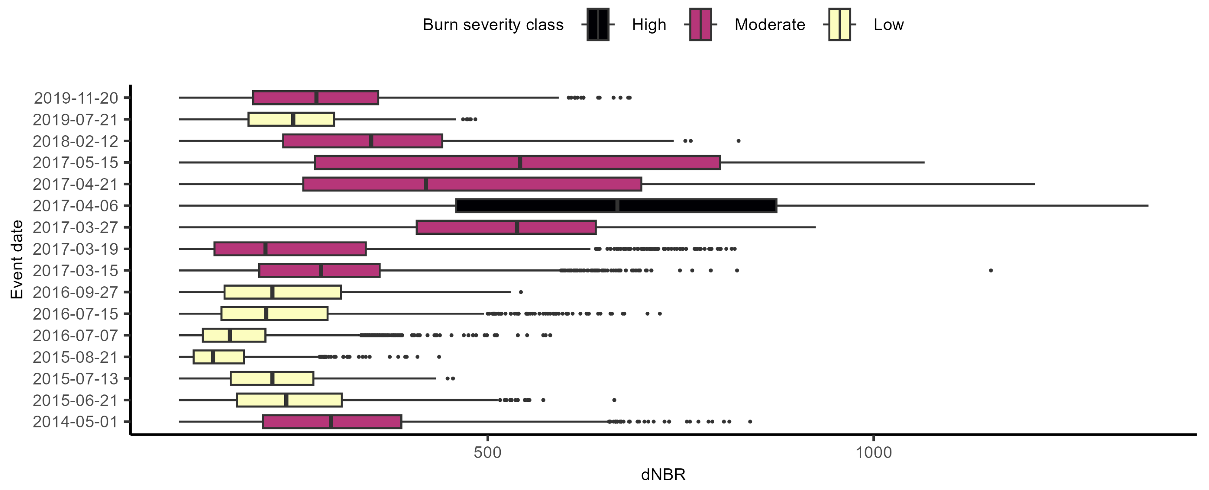
3.1. Burn Severity Across Vegetation and HVRAs

Our analysis revealed that wildfires impacted a diverse range of HVRAs, categorized into Agricultural, Habitat, WUI-Intermix, and WUI-Interface. Habitat was the most common (585.0 km2), followed by Agricultural (101.0 km2), WUI-Interface (5.4 km2), and WUI-Intermix (3.4 km2), respectively accounting for 84.2%, 14.6%, 0.8%, and 0.5% of the total area affected by wildfires. Among these HVRA classes, Atlantic Swamp Forests (411.0 km2), Managed Tree Plantations (99.8 km2), Developed Roads (5.2 km2), and Developed Upland Evergreen Forests (1.5 km2) were the most prevalent for Habitat, Agricultural, WUI-Interface, and WUI-Intermix, respectively. Burn severity exhibited substantial variability between areas treated with prescribed fire for fuel reduction and untreated areas. Treated areas generally exhibited lower median dNBR, although this pattern was not consistent across all HVRAs or vegetation classes. Within LANDFIRE-defined vegetation classes, the greatest reductions in median burn severity for each HVRA were observed in Atlantic Coastal Marsh, Orchards, Developed—Upland Mixed Forest, and Developed—Medium Intensity (Figure 3).

3.2. Predictors Influencing Burn Severity

The model revealed significant, non-linear relationships between post-treatment duration (MSRX) and dNBR, with prescribed fire having a negative effect on wildfire severity across all HVRAs (Figure 4). In Agricultural areas, wildfire severity increased with post-treatment duration, showing signs of leveling off after approximately 36 months, while Habitat areas exhibited a similar upward trend but with a less pronounced plateau effect. Wildfire severity in the WUI-Intermix exhibited a sharp positive increase after approximately 24 months, diverging notably from the more gradual trends observed in Agricultural and Habitat areas. The relationship between MSRX and dNBR in WUI-Interface was less pronounced, following a gentle curvilinear increase, though substantial residual variability likely influenced the slope and overall trend. Five-fold cross-validation on the training set showed strong model performance (mean R2 = 0.913, mean RMSE = 59.6), indicating good generalization. The final model explained 91.6% of the variance in the training set and 89.1% of the variance in the validation set, indicating that the model generalizes well to unseen data.
The parametric coefficients from the model (Table 2) represent the linear effects of different HVRA classes and evaporative demand (EDDI). Habitat served as the reference category, with a baseline intercept for dNBR of 682.0. According to the parametric coefficients, the largest initial reductions in wildfire severity following prescribed fire occurred in WUI-Interface (−244.6, p < 0.001) and WUI-Intermix (−206.9, p < 0.001), followed by Agricultural (−20.1, p < 0.001). Evaporative demand (EDDI) had a significant positive effect on wildfire severity (p < 0.001), increasing dNBR by 76.5 units for each unit increase in EDDI, underscoring the role of drought conditions in amplifying wildfire severity. The smooth terms for MSRX within each HVRA class in Table 2 revealed significant, non-linear relationships, highlighting the interplay between post-treatment duration and HVRA on wildfire severity. The significance of the smooth term for geographic coordinates (p < 0.001) indicates the spline effectively captured the spatial structure, accounting for localized environmental heterogeneity and spatial autocorrelation that influence wildfire severity.

4. Discussion

In this study, we assessed the effectiveness of prescribed fire in mitigating wildfire impacts on HVRAs, comparing treated and untreated areas across multiple wildfires that burned across various HVRAs, allowing for a broad assessment of prescribed fire effectiveness across a mix of natural and built resources. Our results support those of Ross et al. [31], showing that prescribed fires significantly reduced wildfire severity in treated areas, with the greatest reductions occurring within one year post-treatment, particularly in the WUI. These findings underscore the immediate benefits of prescribed fire in high-risk areas where wildfire threats intersect with human development. The variation in wildfire severity across HVRAs in response to post-treatment duration reflects differences in the physical environment, vegetation productivity and flammability, and treatment histories [48].
Consistent with previous research, our findings also demonstrate that fire severity is highly variable across the landscape, occurring in patches of low, moderate, and high severity, with the size and proportion of the patches varying from fire to fire [49,50]. This spatial variability reflects underlying differences in fuels, weather, and other environmental factors [21]. Given the heterogeneous nature of wildfire severity, which is often exacerbated by sensor noise, misregistration, and other factors [51], we trained our model using data from the areas that burned most severely (i.e., the top 10% dNBR) to better characterize wildfire impacts on HVRAs most affected by wildfire.
Our model was able to capture the inherent variability of wildfire across the landscape by incorporating the spatial structure (X and Y coordinates) of the data. This spatial component, influenced by topography, vegetation type, and fuel distribution [52,53], enabled better characterization of localized fire–environment interactions, aligning with studies that emphasize the importance of spatial analysis in understanding and managing fire regimes [54,55]. Utilizing LANDFIRE data, despite their inherent uncertainties, allowed us to differentiate the mitigating effects of prescribed fire across various landcover classes and HVRAs, showing reduced wildfire severity in all four HVRAs identified in this study [43,56].
The influence of drought and atmospheric conditions on fire behavior was characterized with evaporative demand, or EDDI, which reflects atmospheric “thirst” for moisture and serves as a proxy for drought intensity, with higher EDDI values corresponding to increased evaporative stress on vegetation. Increased drought exacerbates wildfire severity by reducing live fuel moisture, drying surface fuels, and increasing the likelihood of ignition and sustained burning. The model results indicate that under conditions of higher EDDI, wildfire severity was amplified across all HVRAs, reinforcing the role of atmospheric drought as a critical driver of fire behavior and burn severity. These findings highlight the importance of incorporating drought metrics into fire risk and severity models to better understand how environmental stressors amplify fire impacts.
Our findings also support the views of southeastern fire managers reported by Kobziar et al. [22], indicating that prescribed fire, which is often applied every two to three years in the southern region, is well suited to balance hazardous fuels reduction and habitat management for sustainability efforts and wildlife conservation, primary objectives of the National Wildlife Refuge System. The trends observed in this study regarding wildfire severity and post-treatment duration are specific to the Southeastern U.S., one of the most ecologically productive regions in the country. In less productive environments—such as those at higher latitudes, elevations, or in more arid regions—the effects of prescribed fire may persist longer than the two- to three-year window documented here. This suggests that prescribed fire strategies may need to be regionally adapted to account for differences in ecological productivity.
Comparing our findings with similar studies in other regions of the United States, such as the western US, shows consistent patterns in the effectiveness of prescribed fire. For instance, studies in California have shown that prescribed fires significantly reduce wildfire severity in chaparral and mixed conifer forests [57,58]. Other studies have demonstrated the benefits of prescribed fire in reducing fuel loads and mitigating wildfire severity in ponderosa pine and other fire-adapted ecosystems [59,60]. In Canada, prescribed fire has been employed in boreal forests to reduce fuel accumulations and prevent large, high-severity wildfires [61,62]. Globally, prescribed fire is used as a management tool in various ecosystems to reduce wildfire severity and promote ecological sustainability [63,64]. These studies highlight the importance of prescribed fire in creating fire-resilient landscapes and reducing the intensity of subsequent wildfires.

Caveats and Considerations

One of the primary goals of this study was to evaluate the efficacy of prescribed fire for mitigating wildfire severity within HVRAs. To achieve this, we categorized LANDFIRE EVT data into HVRAs, which included agricultural land, wildlife habitat, and areas residing within the wildland–urban interface and intermix. While this classification was guided by the framework established by Scott et al. [3], it is crucial to acknowledge the inherent uncertainties within LANDFIRE EVT data, which can influence the accuracy and reliability of our assessments [43,56]. The relatively small sample size of the 16 wildfires—combined with the limited number of high-severity events—may also limit the generalizability of our findings, particularly in regions where large, high-intensity wildfires are more prevalent. While terrain is unlikely to influence outcomes in the relatively flat landscapes of the Southeast, other unmeasured variables such as wind speed and local management practices may have affected fire severity and contributed to the variability in our findings.
Furthermore, our study highlights a critical gap in the availability of a comprehensive and standardized database for HVRAs, which presents significant challenges for developing effective wildfire management and risk assessments [65]. The development of such a database is imperative for a myriad of reasons. For instance, it would enable land managers and policymakers to easily identify and prioritize areas that require protection based on their ecological and socio-economic value. This would facilitate more targeted and efficient allocation of resources for prescribed burns and other fire management practices. It would also enable wildland firefighters to quickly locate and protect HVRAs, ensuring timely and effective response efforts. A comprehensive HVRA database would also enhance the ability to quantify and model the impacts of wildfires and prescribed fires on these assets, leading to more robust and evidence-based decision making [66]. Finally, it would serve as a valuable tool for public awareness and education, emphasizing the role of proactive fire management in promoting sustainability and protecting both natural and built resources.
While significant progress has been made in developing prescribed fire databases, a comprehensive, standardized database that includes both large and small fires conducted on public and private lands at the national scale is still needed [24,39]. Such a database would complement the HVRA database by providing detailed information on the locations, extents, and frequencies of prescribed burns, which is particularly critical as efforts to increase both the pace and scale of prescribed fire implementation continue to grow [67]. This synergy would allow for more precise modeling and analysis of the interactions between prescribed fire treatments and HVRAs. While our study underscores the benefit of prescribed fire in reducing wildfire damage to HVRAs, it also highlights a critical gap in the availability of detailed and accessible data on these resources. Addressing this gap through the creation of comprehensive HVRA and prescribed fire databases would enhance the effectiveness of wildfire mitigation strategies and contribute to the long-term resilience and sustainability of vulnerable landscapes and communities for the benefit of society and future generations.

5. Conclusions

This study reinforces the role of prescribed fire in reducing hazardous fuel loads to mitigate wildfire severity, with the most pronounced benefits observed within one to two years post-treatment. Areas within the WUI experienced the greatest initial reductions in wildfire severity following prescribed fire, highlighting its effectiveness in protecting human communities and infrastructure. However, burn severity in these areas increased more rapidly over time compared to other HVRAs, suggesting that shorter, more frequent treatment intervals may be necessary—especially as increasing drought conditions further exacerbate wildfire severity and alter fire behavior. By reducing wildfire severity, prescribed fire plays a vital role in broader wildfire risk reduction strategies, helping to protect both natural and built environments. These findings emphasize the importance of integrating prescribed fire into long-term land management practices, particularly in the WUI, where fire risks continue to escalate. Through adaptive fire management, land managers can enhance wildfire resilience and promote sustainability across fire-prone landscapes.

Author Contributions

C.W.R., E.L.L., J.J.O., S.A.F. and G.S. conceptualized this analysis and secured the financial support for the project leading to this publication. C.W.R. performed research, data analysis, visualizations, and writing. E.L.L., J.J.O., S.A.F., G.S. and J.K.H. contributed their domain expertise, assisted with writing and revising the manuscript, and provided critical feedback on the study design and interpretation of results. All authors have read and agreed to the published version of the manuscript.

Funding

This research was funded by the Joint Fire Science Program (grant number L21AC10254-00).

Institutional Review Board Statement

Not applicable.

Informed Consent Statement

Not applicable.

Data Availability Statement

All data used in this analysis are publicly available. The dNBR data can be downloaded from the Monitoring Trends in Burn Severity data portal (https://mtbs.gov/direct-download, accessed 12 June 2023), EDDI data can be downloaded from the National Oceanic and Atmospheric Administration data portal (https://psl.noaa.gov/eddi/), vegetation data can be downloaded from the LANDFIRE data portal (https://landfire.gov/evt.php, accessed 1 May 2023), prescribed fire data can be requested from the US Fish and Wildlife Open Data (https://gis-fws.opendata.arcgis.com/).

Acknowledgments

We thank the Joint Fire Science Program for the financial support that made this research possible and Cameron Tongier for providing prescribed fire data.

Conflicts of Interest

The work presented in this paper was conducted while the author was affiliated with the nonprofit organization Tall Timbers. Although the author is now employed by a for-profit entity (First Street), this employer had no involvement in the study.

Abbreviations

The following abbreviations are used in this manuscript:
dNBRDifferenced normalized burn ratio
EDDIEvaporative drought demand index
EVTExisting vegetation
GAMGeneralized additive model
GLMGeneralized linear model
HVRAHighly valued resources and assets
LANDFIRELandscape Fire and Resource Management Planning Tools
MSRXMonths since prescribed fire
MTBSMonitoring Trends in Burn Severity
NBRNormalized burn ratio
NDVINormalized difference vegetation index
NIRNear infrared
NOAANational Oceanic and Atmospheric Administration
NWRNational Wildlife Refuge
SWIRShortwave infrared
USFWSUS Fish and Wildlife
WUIWildland–Urban interface

References

  1. Bowman, D.M.J.S.; Balch, J.K.; Artaxo, P.; Bond, W.J.; Carlson, J.M.; Cochrane, M.A.; D’Antonio, C.M.; DeFries, R.S.; Doyle, J.C.; Harrison, S.P.; et al. Fire in the Earth System. Science 2009, 324, 481–484. [Google Scholar] [CrossRef] [PubMed]
  2. Costanza, R.; d’Arge, R.; de Groot, R.; Farber, S.; Grasso, M.; Hannon, B.; Limburg, K.; Naeem, S.; O’Neill, R.V.; Paruelo, J.; et al. The Value of the World’s Ecosystem Services and Natural Capital. Nature 1997, 387, 253–260. [Google Scholar] [CrossRef]
  3. Scott, J.H.; Thompson, M.P.; Calkin, D.E. A Wildfire Risk Assessment Framework for Land and Resource Management; General Technical Report RMRS-GTR-315; U.S. Department of Agriculture, Forest Service, Rocky Mountain Research Station: Fort Collins, CO, USA, 2013; Volume 83, p. 315. [CrossRef]
  4. Mitchell, R.J.; Liu, Y.; O’Brien, J.J.; Elliott, K.J.; Starr, G.; Miniat, C.F.; Hiers, J.K. Future Climate and Fire Interactions in the Southeastern Region of the United States. For. Ecol. Manag. 2014, 327, 316–326. [Google Scholar] [CrossRef]
  5. Albano, C.M.; Abatzoglou, J.T.; McEvoy, D.J.; Huntington, J.L.; Morton, C.G.; Dettinger, M.D.; Ott, T.J. A Multidataset As-sessment of Climatic Drivers and Uncertainties of Recent Trends in Evaporative Demand across the Continental United States. J. Hydrometeorol. 2022, 23, 505–519. [Google Scholar] [CrossRef]
  6. Abatzoglou, J.T.; Kolden, C.A.; Williams, A.P.; Sadegh, M.; Balch, J.K.; Hall, A. Downslope Wind-Driven Fires in the Western United States. Earth’s Future 2023, 11, e2022EF003471. [Google Scholar] [CrossRef]
  7. Villaverde Canosa, I.; Ford, J.; Paavola, J.; Burnasheva, D. Community Risk and Resilience to Wildfires: Rethinking the Complex Human–Climate–Fire Relationship in High-Latitude Regions. Sustainability 2024, 16, 957. [Google Scholar] [CrossRef]
  8. Radeloff, V.C.; Helmers, D.P.; Kramer, H.A.; Mockrin, M.H.; Alexandre, P.M.; Bar-Massada, A.; Butsic, V.; Hawbaker, T.J.; Martinuzzi, S.; Syphard, A.D.; et al. Rapid Growth of the US Wildland-Urban Interface Raises Wildfire Risk. Proc. Natl. Acad. Sci. USA 2018, 115, 3314–3319. [Google Scholar] [CrossRef]
  9. North, M.P.; Stephens, S.L.; Collins, B.M.; Agee, J.K.; Aplet, G.; Franklin, J.F.; Fulé, P.Z. Reform Forest Fire Management. Science 2015, 349, 1280–1281. [Google Scholar] [CrossRef]
  10. Agee, J.K.; Skinner, C.N. Basic Principles of Forest Fuel Reduction Treatments. For. Ecol. Manag. 2005, 211, 83–96. [Google Scholar] [CrossRef]
  11. Prichard, S.J.; Hessburg, P.F.; Hagmann, R.K.; Povak, N.A.; Dobrowski, S.Z.; Hurteau, M.D.; Kane, V.R.; Keane, R.E.; Kobziar, L.N.; Kolden, C.A.; et al. Adapting Western North American Forests to Climate Change and Wildfires: 10 Common Questions. Ecol. Appl. 2021, 31, e02433. [Google Scholar] [CrossRef]
  12. North, M.P.; York, R.A.; Collins, B.M.; Hurteau, M.D.; Jones, G.M.; Knapp, E.E.; Kobziar, L.; McCann, H.; Meyer, M.D.; Ste-phens, S.L.; et al. Pyrosilviculture Needed for Landscape Resilience of Dry Western United States Forests. J. For. 2021, 119, 520–544. [Google Scholar] [CrossRef]
  13. Loudermilk, E.L.; Stanton, A.; Scheller, R.M.; Dilts, T.E.; Weisberg, P.J.; Skinner, C.; Yang, J. Effectiveness of Fuel Treatments for Mitigating Wildfire Risk and Sequestering Forest Carbon: A Case Study in the Lake Tahoe Basin. For. Ecol. Manag. 2014, 323, 114–125. [Google Scholar] [CrossRef]
  14. DeFazio, P.A. HR 3684—Infrastructure Investment and Jobs Act—(2021–2022). In Proceedings of the 117th Congress. 2021–2022. Available online: https://www.congress.gov/bill/117th-congress/house-bill/3684 (accessed on 15 February 2024).
  15. Yarmuth, J.A. H.R.5376—Inflation Reduction Act of 2022. In Proceedings of the 117th Congress, 2021–2022. Available online: https://www.congress.gov/bill/117th-congress/house-bill/5376 (accessed on 15 February 2024).
  16. Fernandes, P.M.; Botelho, H.S. A Review of Prescribed Burning Effectiveness in Fire Hazard Reduction. Int. J. Wildland Fire 2003, 12, 117–128. [Google Scholar] [CrossRef]
  17. North, M.P.; Collins, B.M.; Stephens, S.L. Using Fire to Increase the Scale, Benefits and Future Maintenance of Fuels Treatments. J. For. 2012, 110, 392–401. [Google Scholar] [CrossRef]
  18. Hiers, J.K.; O’Brien, J.J.; Varner, J.M.; Butler, B.W.; Dickinson, M.; Furman, J.; Gallagher, M.; Godwin, D.; Goodrick, S.; Hood, S.M.; et al. Prescribed Fire Science: The Case for a Refined Research Agenda. Fire Ecol. 2020, 16, 11. [Google Scholar] [CrossRef]
  19. Bond, W.J.; Midgley, J.J. Kill Thy Neighbour: An Individualistic Argument for the Evolution of Flammability. Oikos 1995, 73, 79. [Google Scholar] [CrossRef]
  20. Ross, C.W.; Loudermilk, E.L.; O’Brien, J.J.; Flanagan, S.A.; McDaniel, J.; Aubrey, D.P.; Lowe, T.; Hiers, J.K.; Skowronski, N.S. Lidar-Derived Estimates of Forest Structure in Response to Fire Frequency. Fire Ecol. 2024, 20, 44. [Google Scholar] [CrossRef]
  21. Kobziar, L.N.; Hiers, J.K.; Belcher, C.M.; Bond, W.J.; Enquist, C.A.; Loudermilk, E.L.; Miesel, J.R.; O’Brien, J.J.; Pausas, J.G.; Hood, S.; et al. Principles of Fire Ecology. Fire Ecol. 2024, 20, 39. [Google Scholar] [CrossRef]
  22. Kobziar, L.N.; Godwin, D.; Taylor, L.; Watts, A.C. Perspectives on Trends, Effectiveness, and Impediments to Prescribed Burning in the Southern U.S. Forests 2015, 6, 561–580. [Google Scholar] [CrossRef]
  23. Kolden, C.A. We’re Not Doing Enough Prescribed Fire in the Western United States to Mitigate Wildfire Risk. Fire 2019, 2, 30. [Google Scholar] [CrossRef]
  24. Cummins, K.; Noble, J.; Varner, J.M.; Robertson, K.M.; Hiers, J.K.; Nowell, H.K.; Simonson, E. The Southeastern U.S. Prescribed Fire Permit Database: Hot Spots and Hot Moments in Prescribed Fire across the Southeastern U.S.A. Fire 2023, 6, 372. [Google Scholar] [CrossRef]
  25. McKinney, S.T.; Abrahamson, I.; Jain, T.; Anderson, N. A Systematic Review of Empirical Evidence for Landscape-Level Fuel Treatment Effectiveness. Fire Ecol. 2022, 18, 21. [Google Scholar] [CrossRef]
  26. Key, C.H. Ecological and Sampling Constraints on Defining Landscape Fire Severity. Fire Ecol. 2006, 2, 34–59. [Google Scholar] [CrossRef]
  27. Wulder, M.A.; Masek, J.G.; Cohen, W.B.; Loveland, T.R.; Woodcock, C.E. Opening the Archive: How Free Data Has Enabled the Science and Monitoring Promise of Landsat. Remote Sens. Environ. 2012, 122, 2–10. [Google Scholar] [CrossRef]
  28. Key, C.H.; Benson, N.C. Landscape Assessment (LA). In FIREMON: Fire Effects Monitoring and Inventory System; Lutes, D.C., Keane, R.E., Caratti, J.F., Key, C.H., Benson, N.C., Sutherland, S., Gangi, L.J., Eds.; General Technical Report RMRS-GTR-164-CD; U.S. Department of Agriculture, Forest Service, Rocky Mountain Research Station: Fort Collins, CO, USA, 2006; Volume 164, pp. 1–55. [Google Scholar]
  29. Lentile, L.B.; Smith, A.M.S.; Hudak, A.T.; Morgan, P.; Bobbitt, M.J.; Lewis, S.A.; Robichaud, P.R. Remote Sensing for Prediction of 1-Year Post-Fire Ecosystem Condition. Int. J. Wildland Fire 2009, 18, 594. [Google Scholar] [CrossRef]
  30. Ntinopoulos, N.; Sakellariou, S.; Christopoulou, O.; Sfougaris, A. Fusion of Remotely-Sensed Fire-Related Indices for Wildfire Prediction through the Contribution of Artificial Intelligence. Sustainability 2023, 15, 11527. [Google Scholar] [CrossRef]
  31. Ross, C.W.; Loudermilk, E.L.; O’Brien, J.J.; Flanagan, S.A.; Snitker, G.; Hiers, J.K. Wildfire Severity to Valued Resources Mitigated by Prescribed Fire in the Okefenokee National Wildlife Refuge. Remote Sens. 2024, 16, 4708. [Google Scholar] [CrossRef]
  32. R Core Team. R: A Language and Environment for Statistical Computing; R Foundation for Statistical Computing: Vienna, Austria, 2023. [Google Scholar]
  33. Wickham, H.; Averick, M.; Bryan, J.; Chang, W.; McGowan, L.; François, R.; Grolemund, G.; Hayes, A.; Henry, L.; Hester, J.; et al. Welcome to the Tidyverse. JOSS 2019, 4, 1686. [Google Scholar] [CrossRef]
  34. Pebesma, E. Simple Features for R: Standardized Support for Spatial Vector Data. R J. 2018, 10, 439–446. [Google Scholar] [CrossRef]
  35. Hijmans, R.J. Terra: Spatial data analysis, 2025, R Package Version 1.8-54. Available online: https://cran.r-project.org/web/packages/terra/index.html (accessed on 15 February 2025).
  36. Wood, S.N. Generalized Additive Models: An Introduction with R, 2nd ed.; Chapman and Hall/CRC: Boca Raton, FL, USA, 2017. [Google Scholar] [CrossRef]
  37. Melvin, M. National Prescribed Fire Use Survey Report; Coalition of Prescribed Fire Councils: Monroe, GA, USA, 2018. [Google Scholar]
  38. Grolemund, G.; Wickham, H. Dates and Times Made Easy with Lubridate. J. Stat. Softw. 2011, 40, 1–25. [Google Scholar] [CrossRef]
  39. Eidenshink, J.; Schwind, B.; Brewer, K.; Zhu, Z.-L.; Quayle, B.; Howard, S. A Project for Monitoring Trends in Burn Severity. Fire Ecol. 2007, 3, 3–21. [Google Scholar] [CrossRef]
  40. Miller, J.D.; Knapp, E.E.; Key, C.H.; Skinner, C.N.; Isbell, C.J.; Creasy, R.M.; Sherlock, J.W. Calibration and Validation of the Relative Differenced Normalized Burn Ratio (RdNBR) to Three Measures of Fire Severity in the Sierra Nevada and Klamath Mountains, California, USA. Remote Sens. Environ. 2009, 113, 645–656. [Google Scholar] [CrossRef]
  41. Keeley, J.E. Fire Intensity, Fire Severity and Burn Severity: A Brief Review and Suggested Usage. Int. J. Wildland Fire 2009, 18, 11. [Google Scholar] [CrossRef]
  42. Abatzoglou, J.T. Development of Gridded Surface Meteorological Data for Ecological Applications and Modelling. Int. J. Climatol. 2013, 33, 121–131. [Google Scholar] [CrossRef]
  43. Rollins, M.G.; Rollins, M.G. LANDFIRE: A Nationally Consistent Vegetation, Wildland Fire, and Fuel Assessment. Int. J. Wildland Fire 2009, 18, 235–249. [Google Scholar] [CrossRef]
  44. Hobbins, M.; Wood, A.; McEvoy, D.; Huntington, J.; Morton, C.; Anderson, M.; Hain, C. The Evaporative Demand Drought Index: Part I—Linking Drought Evolution to Variations in Evaporative Demand. J. Hydrometeorol. 2016, 17, 1745–1761. [Google Scholar] [CrossRef]
  45. McEvoy, D.J.; Huntington, J.L.; Hobbins, M.T.; Wood, A.; Morton, C.; Anderson, M.; Hain, C. The Evaporative Demand Drought Index: Part II—CONUS-Wide Assessment Against Common Drought Indicators. J. Hydrometeorol. 2016, 17, 1763–1779. [Google Scholar] [CrossRef]
  46. Frick, H.; Chow, F.; Kuhn, M.; Mahoney, M.; Silge, J.; Wickham, H. Rsample: General Resampling Infrastructure. 2023. Available online: https://cran.r-project.org/web/packages/rsample/index.html (accessed on 15 February 2024).
  47. Pedersen, E.J.; Miller, D.L.; Simpson, G.L.; Ross, N. Hierarchical Generalized Additive Models in Ecology: An Introduction with Mgcv. PeerJ 2019, 7, e6876. [Google Scholar] [CrossRef]
  48. Guyette, R.P.; Stambaugh, M.C.; Dey, D.C.; Muzika, R.-M. Predicting Fire Frequency with Chemistry and Climate. Ecosystems 2012, 15, 322–335. [Google Scholar] [CrossRef]
  49. Collins, B.M.; Stephens, S.L. Stand-Replacing Patches within a ‘Mixed Severity’ Fire Regime: Quantitative Characterization Using Recent Fires in a Long-Established Natural Fire Area. Landsc. Ecol. 2010, 25, 927–939. [Google Scholar] [CrossRef]
  50. Steel, Z.L.; Collins, B.M.; Sapsis, D.B.; Stephens, S.L. Quantifying Pyrodiversity and Its Drivers. Proc. R. Soc. B 2021, 288, 20203202. [Google Scholar] [CrossRef] [PubMed]
  51. Miller, J.D.; Thode, A.E. Quantifying Burn Severity in a Heterogeneous Landscape with a Relative Version of the Delta Normalized Burn Ratio (dNBR). Remote Sens. Environ. 2007, 109, 66–80. [Google Scholar] [CrossRef]
  52. Thompson, J.R.; Spies, T.A.; Ganio, L.M. Reburn Severity in Managed and Unmanaged Vegetation in a Large Wildfire. Proc. Natl. Acad. Sci. USA 2007, 104, 10743–10748. [Google Scholar] [CrossRef]
  53. Parks, S.A.; Dillon, G.K.; Miller, C. A New Metric for Quantifying Burn Severity: The Relativized Burn Ratio. Remote Sens. 2014, 6, 1827–1844. [Google Scholar] [CrossRef]
  54. Finney, M.A. The Challenge of Quantitative Risk Analysis for Wildland Fire. For. Ecol. Manag. 2005, 211, 97–108. [Google Scholar] [CrossRef]
  55. Westerling, A.L.; Hidalgo, H.G.; Cayan, D.R.; Swetnam, T.W. Warming and Earlier Spring Increase Western U.S. Forest Wildfire Activity. Science 2006, 313, 940–943. [Google Scholar] [CrossRef] [PubMed]
  56. Picotte, J.J.; Dockter, D.; Long, J.; Tolk, B.; Davidson, A.; Peterson, B. LANDFIRE Remap Prototype Mapping Effort: Developing a New Framework for Mapping Vegetation Classification, Change, and Structure. Fire 2019, 2, 35. [Google Scholar] [CrossRef]
  57. Stephens, S.L.; McIver, J.D.; Boerner, R.E.J.; Fettig, C.J.; Fontaine, J.B.; Hartsough, B.R.; Kennedy, P.L.; Schwilk, D.W. The Effects of Forest Fuel-Reduction Treatments in the United States. BioScience 2012, 62, 549–560. [Google Scholar] [CrossRef]
  58. Syphard, A.D.; Brennan, T.J.; Keeley, J.E. Extent and Drivers of Vegetation Type Conversion in Southern California Chaparral. Ecosphere 2019, 10, e02796. [Google Scholar] [CrossRef]
  59. Fulé, P.Z.; Crouse, J.E.; Roccaforte, J.P.; Kalies, E.L. Do Thinning and/or Burning Treatments in Western USA Ponderosa or Jeffrey Pine-Dominated Forests Help Restore Natural Fire Behavior? For. Ecol. Manag. 2012, 269, 68–81. [Google Scholar] [CrossRef]
  60. Brodie, E.G.; Knapp, E.E.; Brooks, W.R.; Drury, S.A.; Ritchie, M.W. Forest Thinning and Prescribed Burning Treatments Reduce Wildfire Severity and Buffer the Impacts of Severe Fire Weather. Fire Ecol. 2024, 20, 17. [Google Scholar] [CrossRef]
  61. Weber, M.G.; Taylor, S.W. The Use of Prescribed Fire in the Management of Canada’s Forested Lands. For. Chron. 1992, 68, 324–334. [Google Scholar] [CrossRef]
  62. Hély, C.; Fortin, C.M.-J.; Anderson, K.R.; Bergeron, Y. Landscape Composition Influences Local Pattern of Fire Size in the Eastern Canadian Boreal Forest: Role of Weather and Landscape Mosaic on Fire Size Distribution in Mixedwood Boreal Forest Using the Prescribed Fire Analysis System. Int. J. Wildland Fire 2010, 19, 1099–1109. [Google Scholar] [CrossRef]
  63. Marchi, M.; Chianucci, F.; Ferrara, C.; Pontuale, G.; Pontuale, E.; Mavrakis, A.; Morrow, N.; Rossi, F.; Salvati, L. Sustainable Land-Use, Wildfires, and Evolving Local Contexts in a Mediterranean Country, 2000–2015. Sustainability 2018, 10, 3911. [Google Scholar] [CrossRef]
  64. Smith, C.; Perkins, O.; Mistry, J. Global Decline in Subsistence-Oriented and Smallholder Fire Use. Nat. Sustain. 2022, 5, 542–551. [Google Scholar] [CrossRef]
  65. Gonzalez-Mathiesen, C. Challenges in Developing Wildfire Understanding from Wildfire Information through Spatial Planning Processes. Sustainability 2024, 16, 420. [Google Scholar] [CrossRef]
  66. Marques, S.; Marto, M.; Bushenkov, V.; McDill, M.; Borges, J. Addressing Wildfire Risk in Forest Management Planning with Multiple Criteria Decision Making Methods. Sustainability 2017, 9, 298. [Google Scholar] [CrossRef]
  67. Varner, J.M.; Hiers, J.K.; Wheeler, S.B.; McGuire, J.; Quinn-Davidson, L.; Palmer, W.E.; Fowler, L. Increasing Pace and Scale of Prescribed Fire via Catastrophe Funds for Liability Relief. Fire 2021, 4, 77. [Google Scholar] [CrossRef]
Figure 1. Map showing centroids of wildfire perimeters that overlapped with prescribed fire records on seven National Wildlife Refuges (NWRs) in Florida and Georgia. These sites—Florida Panther (FPR), Lake Woodruff (LWR), Merritt Island (MIR), Okefenokee (OKR), St. Johns (SJR), St. Marks (SMR), and Savannah (SVR)—were selected based on the availability of spatial fire records from the U.S. Fish and Wildlife Service. A total of 18 wildfire events were identified from 2013 to 2023.
Sustainability 17 06230 g001
Figure 2. The severity and variability of 16 wildfire events that intersected with the prescribed fire treatment records. The y-axis represents the dates of wildfire events; the x-axis corresponds to dNBR. Burn severity classes correspond to the classification scheme proposed by Keely et al. [41] in Table 1.
Sustainability 17 06230 g002
Figure 3. Boxplot showing the percentage difference in dNBR between treated and untreated areas across various LANDFIRE-defined vegetation classes, grouped according to Highly Valued Resources and Assets (HVRAs). Negative values correspond to areas where wildfire severity was lower in prescribed fire-treated areas relative to untreated areas. The HVRAs are categorized into Agricultural (red), Critical Habitat (green), WUI-Interface (cyan), and the WUI-Intermix (purple).
Sustainability 17 06230 g003
Figure 4. Partial effects subset of LANDFIRE-defined vegetation classes from the fitted generalized additive model. The x-axis indicates months since prescribed fire treatment. The zero line on the y-axis represents the model intercept (overall mean response); negative values indicate a reduction in dNBR relative to the mean, while positive values indicate an increase, conditional on other model terms.
Sustainability 17 06230 g004
Table 1. Proposed burn severity levels obtained by calculating dNBR [41].
Burn Severity ThresholdsdNBR
Enhanced Regrowth, high (post-fire) −500 to −251
Enhanced Regrowth, low (post-fire) −250 to −101
Unburned−100 to +99
Low Severity +100 to +269
Moderate–low severity+270 to +439
Moderate–high severity+440 to +659
High severity+660 to +1300
Table 2. Summary of the results from the generalized additive model analyzing the relationship between dNBR, vegetation types, Evaporative Drought Demand Index (EDDI), fire frequency, and spatial coordinates (X, Y). The model explains 83.9% of the deviance, with an adjusted R-squared of 0.829, based on 4385 observations.
FamilyLink FunctionFormulaAdjusted R2Deviance Explained
GaussianIdentity 0.82983.9%
Parametric coefficients
EstimateStd. ErrorT-valuePr(>|t|)
(Intercept)682.014.945.5<0.001
Agricultural−20.12.6−7.6<0.001
WUI-Interface−244.69.3−26.1<0.001
WUI-Intermix−206.917.3−11.9<0.001
EDDI76.510.37.3<0.001
Approximate Significance of Smooth Terms
edfRef.dfFp-value
s(Habitat)1.91.9157.7<0.001
s(Agricultural)1.91.9140.8<0.001
s(WUI-Interface)1.61.86.8<0.001
s(WUI-Intermix)1.81.923.4<0.001
s(X, Y)28.628.9462.7<0.001
Disclaimer/Publisher’s Note: The statements, opinions and data contained in all publications are solely those of the individual author(s) and contributor(s) and not of MDPI and/or the editor(s). MDPI and/or the editor(s) disclaim responsibility for any injury to people or property resulting from any ideas, methods, instructions or products referred to in the content.

