Abstract
An important historical and cultural region in southern China, the Xiangjiang River Basin, has formed a unique spatial pattern and regional cultural characteristics in its long-term development. In recent years, the acceleration of urbanization has led to the historical texture and cultural elements of Changsha’s suburban blocks facing deconstruction pressure. How to identify and protect their cultural value at the spatial structure level has become an urgent issue. Taking three typical traditional township blocks in the suburbs of Changsha as the research object, this paper constructs a trinity research framework of “spatial gene identification–diversity analysis–strategy optimization.” It systematically discusses the makeup of the types, quantity, distribution, relative importance ranking, and diversity characteristics of their spatial genes. The results show that (1) the distribution and quantity of spatial genes are affected by multiple driving forces such as historical function, geographic environment, and settlement evolution mechanisms, and that architectural spatial genes have significant advantages in type richness and importance indicators; (2) spatial gene diversity shows the structural characteristics of “enriched artificial space and sparse natural space,” and different blocks show clear differences in node space and boundary space; (3) spatial genetic diversity not only reflects the complexity of the spatial evolution of a block but is also directly related to its cultural inheritance and the feasibility of renewal strategies. Based on this, this paper proposes strategies such as building a spatial gene database, improving the diversity evaluation system, and implementing differentiated protection mechanisms. These strategies provide theoretical support and methods for the protection and sustainable development of cultural heritage in traditional blocks.
1. Introduction
The concept of spatial genes originated from biology and was first proposed by Wilhelm Ludwig Johnson, a Danish geneticist, in 1909 [1]. In the 20th century, with the rise of urban morphology, the concept was gradually introduced into the field of human geography and urban design to reveal the evolution of urban spatial structures. The German scholar Slote put forward the concept of “form generation,” emphasizing the self-organization of urban space during long-term development. The Kang Enze school further developed the “urban plane pattern analysis method” [2] to explore its mechanisms of generation by identifying stability and variability elements within morphological structures. At the same time, the study of urban morphology and landscape urbanism has gradually become an important means of developing the concepts of urban evolution and spatial texture, showing independent theoretical value in the protection of traditional blocks and historical heritage. In the process of deepening the theory, the research paradigm of spatial genes has gradually expanded from early static form description to the comprehensive interpretation of social, historical, cultural, and other multidimensional factors [3,4,5,6]. In the local context of China, Duanjin and other scholars introduced the concept of gene theory into urban and rural spatial research and put forward the analytical framework of “feature recognition gene analysis evaluation optimization,” promoting the localized development of spatial gene theory in urban and rural spatial governance and cultural protection [7,8].
Against this theoretical background, the traditional township blocks in the Xiangjiang River Basin show significant research value. This region is located in southeastern China and is an important distribution area for the Xianggan ethnic group, one of the five major ethnic groups of the Han Chinese.It has been under unified high-level administrative control for a long time, allowing for continuous and stable cultural accumulation [9]. From the perspective of settlement morphology evolution, the traditional blocks in this region are generally built on water, and the water system not only provides basic ecological support but also fulfills the important functions of transportation, communication, and cultural transmission [10]. In the southern region especially, the river and shipping system often replace the road system and become key factors affecting settlements’ spatial layout and paths of cultural transmission. Under the joint action of this natural pattern and human influences, the Xiangjiang River Basin has gradually seen the formation of a traditional township block system with a compact structure, complex functions, and a highly integrated culture [11]. These blocks are composed of historic buildings, traditional streets and alleys, and square nodes, and the overall spatial texture retains profound regional cultural characteristics and traces of historical evolution [12,13].
However, with the continuous acceleration of urbanization, the spatial form and cultural connotation of traditional settlements are facing unprecedented impacts. On the one hand, regional spatial patterns are becoming increasingly blurred and organizational logic within traditional settlements is facing deconstruction. On the other hand, intangible cultural heritage (such as local spirit and social style) also faces the risk of rapid weakening or even fracturing [14,15]. The cultural memory and historical continuity embodied in traditional blocks are declining, which poses a severe challenge to the identity and continuity of urban and rural space. In this context, how to find a balance between protection and development and explore the mechanism of cultural identification and continuity from the perspective of spatial genes has become an important issue in urban and rural spatial research.
2. Literature Review
With the deepening of research, the quantitative evaluation of spatial gene characteristics and organization rules has become an important research method to measure cultural heritage and spatial evolution in traditional settlements. Existing studies mainly start from morphology, dividing settlements into different spatial types by extracting key elements such as street space, architectural space, and node space, and quantitatively analyzing their structural logic and evolution modes by combining spatial syntax analysis, fractal dimension calculation, and other methods [16,17]. These methods have achieved remarkable results in revealing the hierarchy and organization of rule in traditional settlement space, but have somewhat ignored the expression of diversitycharacteristics within this space. To make up for this deficiency, Huang and other scholars introduced the concept of “spatial genetic diversity” and applied it to the study of traditional villages, attempting to quantitatively reflect the cultural value, natural attributes, and evolutionary path followed by monomer space and group structures in settlements from a multi-dimensional perspective [18,19]. The method takes the diversity index as the core, and systematically describes the heterogeneity, balance, and system coupling relationships between spatial components, which provides a new analytical dimension and theoretical support for understanding the complexity and integrity of traditional settlements’ spatial form, and further expands the breadth and depth of spatial genetic research [20,21]. In addition, some researchers have combined spatial gene analysis with modern technological means, for example, identifying the changes in rural settlement morphology through sub-meter remote sensing and deep learning to reveal the spatial distribution characteristics of settlements [22]. Based on GIS and remote sensing, this paper analyzes the evolution mechanism of traditional settlements in the Jiangnan hilly area to provide empirical support for the change in rural spatial structure [23]; more studies have analyzed the spatial evolution path of ethnic minority villages under the pressure of tourism development through the combination of remote sensing, GIS and qualitative analysis [24]. At the urban scale, Braun et al. (2023) proposed a universal urban structure type (UST) recognition scheme using high-resolution remote sensing data, emphasizing the application potential of remote sensing in the objective identification of spatial types [25].
In general, the spatial genetic diversity theory has gradually matured quantitatively, but most of the research remains focused on the research objects, such as traditional settlements and urban historical blocks [26,27,28], and research on spatial gene feature recognition and diversity evaluation at the township scale is still relatively lacking. Particularly in the field of traditional township blocks, most existing studies focus on the practical guidance of “protection and renewal”: starting from the restoration of historical buildings and the renovation of streets and alleys, it emphasizes the repair and continuation of material forms [29,30,31]. From the perspective of planning and design, landscape design and form guidance are based on local cultural values [32,33]. In terms of cultural inheritance, it focuses on the protection and dissemination of intangible cultural heritage, local skills and festival activities [34,35]; however, under the logic of tourism development, it focuses on the commercial transformation of space and the creation of tourist experiences [36,37,38]. Taking a comprehensive view of the current research, it mainly shows the following three characteristics: first, the research scale is mainly villages and urban blocks, and insufficient attention is paid to township-level spatial units, especially in the context of the Xiangjiang River Basin; second, in terms of research content, although the research on cultural characteristics identification and resource development is relatively mature, systematic quantitative identification and classification from the perspective of spatial gene is still a weak link in the research; third, at the level of research methods, qualitative description is still dominant, and there have been relatively few attempts to reveal the characteristics of spatial structure and evolution mechanism with quantitative tools.
Therefore, from the perspective of “spatial genetic diversity,” this paper focuses on the typical traditional township blocks in the Xiangjiang River Basin to carry out systematic research. The research is conducted at three levels: First, the spatial gene recognition framework for traditional township blocks is constructed, and the spatial types and gene loci within the blocks are extracted and classified; second, the diversity index and importance index are used to quantitatively analyze various spatial genes to reveal their structural characteristics and distribution patterns; third, combined with the analysis results, the paper identifies the main problems that exist in the protection and development of the block, and proposes targeted optimization paths and strategy suggestions. This study is expected to provide theoretical support and a methodological reference for the cultural heritage protection, spatial governance, and the organic renewal of traditional blocks in the Xiangjiang River Basin.
3. Research Subjects and Methods
3.1. Research Object
The scope of this study is the Wangcheng District of Changsha City (geographical coordinates: 112°35′48′′ E–113°02′30′′ E, 27°58′28′′ N–28°33′45′′ N). This area is located in the north of central Hunan Province and Changsha City, belonging to the suburban township area of Changsha City. Wangcheng District is located in the Xiangjiang River Basin, with a typical humid subtropical monsoon climate. The region has abundant annual precipitation and four distinct seasons, especially in summer, with obvious characteristics of a high temperature and a rainy season. The humid climate is one of the significant natural characteristics of the region. The annual average temperature in the urban area is 17.2 °C, the annual average precipitation is 1361.6 mm, and humidity is high, with an annual average humidity of about 78%. These climatic conditions have an important impact on the natural environment and social functions of Wangcheng District, and shape the formation of the spatial form and functions of the traditional township blocks (Figure 1).
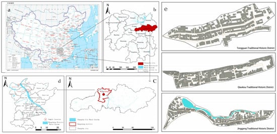
Figure 1.
Research scope: (a) Hunan Province, China; (b) Changsha City, Hunan Province; (c) Wangcheng District, Changsha City; (d) location of research sample blocks in Wangcheng District; (e) block texture map. Non-English content notes: The Chinese labels and approval number on the map are legally required for official maps of China. English translations of place names are supplementary for international readers.
The climate characteristics, rich water resources, and urban–rural transition in Wangcheng District jointly create a unique natural and social environment for the formation and development of the traditional township blocks in this area. In particular, the water system and humid climate in the Xiangjiang River Basin have significantly impacted the spatial layout, architectural style, and functional organization of traditional blocks [39,40]. Therefore, this study selects three traditional blocks in Wangcheng District adjacent to the Xiangjiang River Basin, as research cases. These blocks are the Qiaokou, Tongguan, and Jinggang blocks. As a typical fishing port and water town, a Millennium Pottery City, and an important commercial port, respectively, the three reflect Wangcheng District’s core river-dependent nature. They have distinctive regional cultural characteristics and unique spatial layouts, reflecting the diversity of the history, culture, and functions of the traditional township blocks in the Wangcheng District. (Table 1). This study aims to investigate how various natural environments, historical backgrounds, and geographical factors interact to shape the rules and characteristics of spatial genetic diversity in traditional township blocks.

Table 1.
Basic information about sample blocks.
3.2. Research Methods
3.2.1. Spatial Gene Recognition and Extraction Framework
- (1)
- Spatial Gene Quadrat Settings
Based on the hierarchical model of plant communities and the theoretical framework of this model, this study further divides the traditional township blocks into multiple sub-levels according to their spatial characteristics [41]. As a basic concept in ecology, the hierarchical structure of plant communities emphasizes the orderly arrangement and distribution of communities in space and points out that there are interactions and feedback mechanisms between communities at different levels and the environment [42,43]. This hierarchical model has been widely used in spatial analysis, especially in research on spatial genetics, providing important theoretical support. Based on this framework, the spatial structure of traditional township blocks can also be seen as a hierarchical distribution, especially in terms of street organization and spatial distribution, which are highly similar to the distribution characteristics of plant communities (Figure 2). The introduction of this model is helpful for understanding the internal relationships and interactions between different spatial levels.

Figure 2.
(a) Biological community plot division method; (b) plot division diagram of spatial gene survey in traditional blocks.
Firstly, based on the specific manifestations of spatial genes, they are divided into two main categories: material spatial genes and non-material spatial genes. Material spatial genes have clear quantitative and volumetric properties, which can be identified through objective observation and measurement. Relatively speaking, non-material spatial genes lack these physical attributes and are more manifested in abstract forms such as culture and consciousness, relying on material spatial genes for their existence and expression. Secondly, considering the positional differences in spatial genes in the structural hierarchy of historical and cultural blocks, they can be subdivided into two types of spatial genes: internal and external. External spatial genes are mainly reflected in the natural environment of the block, while internal spatial genes focus more on the architectural cluster characteristics within the block. These two types of spatial genes have clear boundary attributes in terms of location, together forming the complete spatial structure of historical and cultural blocks. In addition, according to the different functional roles of spatial genes in historical and cultural blocks, they can be further subdivided into architectural spatial genes, street spatial genes, water system spatial genes, etc.
Combined with the field survey results and referring to the hierarchical model of plant communities, this study divides the traditional township blocks in Changsha into five spatial levels: the external environment layer, the boundary environment layer, the architectural form layer, the street and lane organization layer, and the node environment layer (Figure 3) [44]. This division of these spatial levels is based on the blocks’ spatial function and layout and the historical and cultural characteristics of the block, aiming to comprehensively present the impact of the internal and external environment of the block on its spatial organization and structure. Specifically, the external environment layer focuses on the role of the natural environment and urban infrastructure surrounding the block; the boundary environment layer analyzes interfaces between the block and its environment; the architectural form layer focuses on the forms, structure, and spatial expression of buildings in the block; the organizational layer of streets and lanes emphasizes layout and functionality of lanes; and the node environment layer studies key nodes’ interactions with their surroundings.
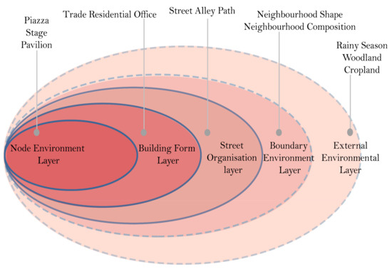
Figure 3.
Spatial hierarchy of traditional township blocks in Changsha.
- (2)
- Spatial Gene Recognition And Extraction Framework
From the perspective of spatial gene theory, the formation of space is not a static process but gradually develops through self-organization, long-term evolution, change, and cultural inheritance. This evolutionary process shapes the spatial form of the block and endows it with unique structural and functional characteristics. Therefore, the identification and extraction of spatial genes should not only focus on their spatial structure and functional characteristics but also consider their dynamic changes and historical influences. Specifically, a spatial gene in traditional township blocks refers to fundamental elements and their interrelationships that form the spatial structure and function within a specific geographical context. These elements include both the natural environment and architectural structure as well as the interaction between the internal and external environment of the block, the impact of historical–cultural heritage, and social functional patterns.
In this study, the methods of element identification and quantity extraction were used to identify and extract the spatial gene units at the above five levels, which provided the data basis for the subsequent spatial diversity analysis. The specific steps are as follows: The first is element recognition, which extracts the spatial gene by analyzing the key elements at the spatial level (such as architectural form, street organization, natural environment). This process helps to clarify the main characteristics of each spatial level and reveals how these characteristics constitute the spatial genes of the block. The second is quantitative extraction, which counts and analyzes spatial genes by calculating the number or distribution of specific spatial elements. For example, street/lane counts, building heights, node quantities. Through quantitative extraction, we can analyze the quantitative characteristics of spatial genes in traditional township blocks and provide accurate data support for subsequent spatial gene diversity analysis. In the actual extraction process, we found that spatial genes like water systems, cultivated land, forests, and boundaries are difficult to quantify accurately using traditional quantitative methods. Therefore, this study uses qualitative and quantitative analysis methods of spatial genetics for reference, and divides spatial gene loci into qualitative gene loci and quantitative gene loci [27,39], which are specifically described as follows:
- (1)
- Qualitative genes: These genes cannot be measured by quantity, and usually represent the existence or deletion of a certain spatial level. For example, the external environment layer (such as green space and open space) and the boundary environment layer (such as rivers and traffic roads) in the block. The presence or absence of these genes has a significant impact on the environment and function, so “0” indicates deletion, and “1” indicates presence.
- (2)
- Quantitative genes: These genes can be measured by specific quantities, and are usually related to physical elements, such as the architectural form layer, street and lane organization layer, and node environment layer in traditional blocks. Quantitative genes can accurately reflect the density and structural characteristics of a region in the spatial layout, such as the number of streets and lanes, building height, node number, and so on.
Finally, this study proposes a framework for spatial gene identification and the extraction of traditional township blocks in Changsha. See Table 2 for details.
Table 2.
Spatial gene extraction framework for traditional township blocks in Changsha.
3.2.2. Diversity Measurement Indicators
This study employs key measurement indices, including importance value, the Margalef index, Shannon index, Simpson index, Pielou evenness index, and other measurement indicators [45,46,47,48], to reflect the diversity characteristics of spatial genes from different dimensions. Specifically, the importance value quantifies the relative importance of each spatial gene within the block structure and reveals its functional role. The Margalef index measures spatial gene diversity, reflecting the types and quantities of genes present in a block. The Shannon and Simpson indices evaluate the distribution uniformity and diversity of spatial genes, respectively; the former focuses on the uncertainty of information, while the latter emphasizes the spatial concentration or dispersion of genes. Pielou’s evenness index further assesses the uniform distribution of spatial genes in traditional township blocks and evaluates the consistency of their distribution. Collectively, these indices accurately quantify the spatial gene diversity characteristics of township blocks under internal and external environmental influences, providing a quantitative basis for spatial structure analysis (Table 3).
Table 3.
Calculation formula for spatial gene diversity index.
3.3. Data Processing Process
- (1)
- The following are the four steps of data processing (Figure 4): Collection of spatial data: In October 2024, UAVs equipped with an orthophotography function were used to survey the whole area of the block according to the automatically planned route to collect high-precision orthophotography data. Through Pix4Dmapper (4.4.12 version) aerial survey software, multiple local orthophotos were spliced into complete satellite images. At the same time, through on-site mapping and photographing in November 2024, infrared measuring instruments and cameras were used to collect data such as the floor height of houses, the height-to-width ratio of streets and alleys, and the architectural style.
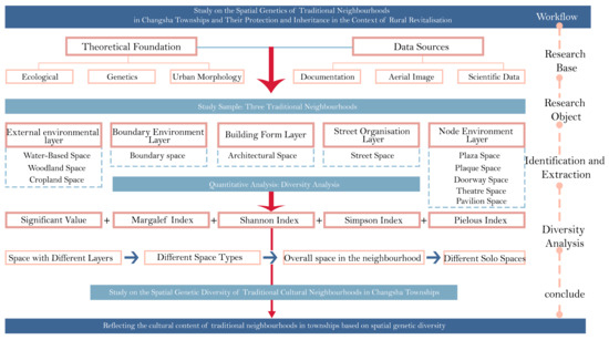 Figure 4. Data processing flow chart.
 - (2)
- Identification and extraction of spatial genes: according to the field survey and collected spatial data, the system identifies different spatial genes in the block. Through the analysis of the historical and cultural characteristics, architectural form, street structure, and external environment of the block, the key spatial genes affecting the spatial structure and function of the block are determined.
- (3)
- Construction of spatial gene dataset: Based on the theoretical framework of spatial genes and the hierarchical model of community science, five spatial gene hierarchies (external environment layer, boundary environment layer, building shape layer, street and lane organization layer, node environment layer) were established, and five spatial gene datasets were further identified and extracted. The dataset contains the functional attribute characteristics of different spatial gene units at different levels, and provides data support for subsequent spatial diversity analysis.
- (4)
- Diversity statistical analysis: We used Excel and Origin (2022 version) to calculate the diversity index and the importance value of genes, and visually map the spatial gene dataset, to analyze the diversity characteristics of block space.
4. Results and Analysis
4.1. Analysis of Quantitative Characteristics of Spatial Genes
4.1.1. Quantitative Analysis of Spatial Genes of Traditional Blocks in Changsha
It can be seen from Table 4 that the Jinggang traditional block has the most spatial gene types, followed by the Tongguan block, while the Qiaokou block has the fewest spatial gene types. In terms of the number of loci, the Jinggang and Tongguan blocks have the highest number of loci, while the Qiaokou block has the lowest number of loci. Although the spatial types of the three blocks show little difference, the Qiaokou block is still the lowest, while the Jinggang and Tongguan blocks are the highest. These differences reflect the differences in the history, culture, and social functions of each block. Specifically, Jinggang has the largest number and variety of spatial genes, mainly because the prosperity of the water transport trade and the profound accumulation of commercial port culture in its historical development provide a rich historical background and cultural resources for the spatial form of traditional blocks. In contrast, Qiaokou has a long history, but its relatively simple natural environment and cultural heritage make its spatial genes relatively small, especially in terms of the number of gene loci.
Table 4.
Statistical results for spatial gene types in blocks in different traditional towns.
According to the field survey results, Jinggang has the most spatial gene types in the three blocks, and its gene loci and spatial types are also the most abundant. The formation of this spatial pattern is mainly due to the differences in historical development. Jinggang, as the best-preserved commercial water town in Changsha from the Ming and Qing Dynasties, enjoys the reputation of “little Hankou” due to its prosperous water transport trade in the past. The commercial port culture it developed has promoted the complete preservation of the traditional street pattern and the architectural style of the Ming and Qing Dynasties. At the same time, Tongguan District, as a ceramic cultural center with a long history, has rich spatial genes, but due to the impact of modernization and urbanization, the inheritance and retention of traditional spatial elements are not as complete as on Jinggang, so the types and number of spatial genes are slightly inferior to those in Jinggang. Relatively speaking, the Qiaokou block is weak in the diversity and richness of spatial genes due to its relatively simple natural environment and architectural style, as well as having less cultural heritage. To sum up, the difference in the number of different spatial gene types is closely related not only to the historical and cultural background of each block, but also to their social functions and economic development level.
4.1.2. Quantitative Analysis of Genes in Different Spatial Types
It can be seen from Table 5 that the number of individual gene in the architectural space, street space, square space, and gate space in traditional township blocks is significantly higher, followed by memorial archway space, stage space, and pavilion space, and the number of individual genes in the water system space, forest land space, cultivated land space, and boundary space is lower. The distribution of the number of gene categories shows a similar trend, with architectural space, street space, and square space in first place, pavilion space, gateway space, and memorial archway space in the middle, and water system space, forest land space, cultivated land space, and boundary natural space still in last place. Except for the fact that the number of gene loci in architectural space is significantly outstanding, the difference among other spatial types is small, but the number of gene loci in natural space is still the lowest. These differences are mainly due to the use frequency and cultural value of different functional spaces in the towns’ historical development. Specifically, as the core carrier of the daily public activities of township residents, buildings, streets, and squares have long carried the functions of commercial trade, social gatherings, and folk rituals in township blocks, thus accumulating a wealth of spatial gene types and loci. In contrast, although water systems, forest land, and cultivated land play an important role in ecology and production, their spatial forms are greatly constrained by natural conditions and less manual intervention, resulting in relatively limited genetic diversity.
Table 5.
Statistical results for gene quantities in different spatial types.
According to the field survey, gene carriers are more abundant in architectural space, street space, square space, and gate space, with the number of gene categories and gene loci being relatively rich. These spatial gene distribution characteristics are closely related to the historical evolution of each functional space. Architectural space, as a carrier of multiple functions including residence, commerce, and trade, exhibits rich gene expression; street space, as the main venue for commerce and social communication, has continuously strengthened sequence characteristics; and square space has accumulated diverse genes driven by public activity requirements. The middle-state characteristics of gate space and memorial archway space genes align with their functional positioning as social markers. In contrast, natural spaces such as water system space and forest land exhibit simple gene expression owing to their single function and limited human intervention. In summary, traditional township blocks display a distribution pattern of “rich artificial space and sparse natural space,” directly reflecting the spatial organization characteristics of traditional townships.
4.2. Analysis of Spatial Gene Importance Characteristics
Figure 5a demonstrates that the comprehensive importance values of genes in architectural space, street space, square space, and gate space are high, with architectural space values being significantly higher than those of other space types, whereas the comprehensive importance values of natural genes in water system space, forest land space, cultivated land space, and boundary space are low. Figure 5b shows that out of all the comprehensive importance value of gene loci in various spaces, the comprehensive importance value of gene loci in architectural space is dominant, and the value of facade style in particular is the highest. Further analysis (Figure 5c) reveals that the top ten spatial genes with the highest important values all belong to the category of architectural space, among which 1–3 floors have the highest important values. These differences indicate that the spatial gene distribution of traditional township blocks exhibits significant function-oriented characteristics. Specifically, the absolute advantage of the architectural space gene in the distribution of comprehensive importance values and loci highlights their core position in traditional block spatial forms, a phenomenon closely related to the function of the Jinggang and Tongguan blocks as trade hubs in history. Conversely, the comprehensive importance value of the natural space gene may stem from the decline in water transport and natural space compression during modern urbanization.
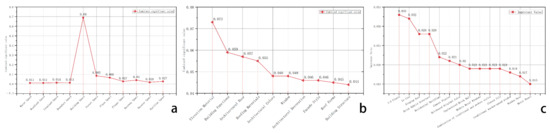
Figure 5.
(a) Comprehensive importance values of genes of different spatial types; (b) comprehensive important values of different gene loci; (c) importance values of different spatial genes.
According to the field survey, the Horsehead wall, carved doors and windows, etc., directly reflect the historical style and cultural characteristics of the block, and are the intuitive expression of the regional architectural language. At the same time, buildings with a modern style reflect the adaptive evolution of the block in the process of modernization. The number of building floors (1–3) has the highest genetic importance value in the architectural space type. The reason for this is that the low-rise building form in traditional blocks is an inevitable choice under the dual effects of historical construction technology and functional requirements. To sum up, the difference in the comprehensive importance value of the different spatial genes is not only closely related to the commercial function of the block, but also the result of the adaptability of historical construction technology.
4.3. Analysis of Spatial Gene Diversity Characteristics
4.3.1. Analysis of Spatial Gene Diversity at Different Levels
It can be seen from Table 6 that the Margalef indexes at the different levels of the three sample blocks are significantly different. The indexes of the building shape layer and node environment layer of each block are higher, while those of the external environment layer and boundary environment layer of the block are lower. Among them, Jinggang has the highest building shape index, followed by Tongguan and Qiaokou. In the node environment layer, the Jinggang Margalef index is the highest, followed by Tongguan, and Qiaokou is still the lowest. In contrast, the difference in the natural environment layer of each block is very small, but it is at the lowest level of all layers. These differences reflect the differences in the history, culture, and social functions of each block. Specifically, the Jinggang block has the highest Margalef index in the architectural form layer and node environment layer, which indicates that its architectural types, spatial forms, public spaces, and node structures are highly diverse. The Margalef index of the natural environment layer is the lowest, indicating that the landscape pattern and natural terrain of the traditional block are relatively stable, and follow the ecological concept of coexistence between man and nature. According to the field survey, the Jinggang block has the highest Margalef index in the architectural form layer and node environment layer. The reason for this is that, as the best preserved commercial water town in the Ming and Qing Dynasties in the suburbs of Changsha, its history of water transport and trade has promoted the development of wharves, shops, banks, and other characteristic spaces, and generated a unique Huxiang commercial port culture, resulting in a rich variety of architectural types and node space forms. The natural environment layer is generally the lowest, which is mainly because the natural landscape pattern is greatly constrained by nature and less manual intervention, forming a single gene model, and also shows that township’s residents advocate for the ecological concept of “following the trend” for the natural environment.
Table 6.
Statistical results for gene diversity indexes at various spatial levels in traditional township blocks.
According to the Shannon and Simpson indexes, the architectural shape and structure of the three blocks are the highest; among which, the Tongguan block has the highest index, followed by Jinggang and Qiaokou. This shows that the most abundant architectural forms are in Tongguan, where there are the numerous types. This difference is mainly due to the historical background of Tongguan as an important ceramic-producing area on the “maritime Silk Road” in the Tang Dynasty, which led to the formation of a unique type of architecture. At the same time, as a ceramic manualproduction research base, influenced by urbanization, Tongguan has produced various kinds of buildings which are different from the traditional elements of this block. The Pielou index of each block shows little difference, especially as the indexes of the external environment layer and the boundary environment layer are consistent, indicating that the water systems, cultivated land, mountains, and boundary types are common in each block.
4.3.2. Analysis of Diversity Characteristics of Different Spatial Types
It can be seen from Table 7 that there are differences in the Margalef indexes of various spaces. The architectural space index is the highest, followed by the memorial archway space, the square space, and other spaces, and the indexes of the water system space and forest land space are the lowest. The highest Margalef index being for architectural space indicates the diversified architectural forms and functional types formed in the historical evolution of traditional settlements. The lowest indexes being for water system space and forest space reflect that these natural elements show clear type unity and structural stability in the gene pool of traditional settlement space. The highest Margalef index being for architectural space is mainly due to the historical position of the block as a regional economic and cultural node. Jinggang’s water transportation trade, Tongguan’s ceramic industry, Qiaokou’s fishing and agricultural economy, and other characteristic functions have given birth to different types of buildings. After a long period of historical stratification, the construction techniques and styles of different periods coexist in the block, which has become a diversity overlay in the time dimension. The reason for the low spatial indexes of water systems and forest land is the inherent interaction mode between traditional waterfront settlements and the natural environment. This low variation characteristic reflects the traditional ecological wisdom of “harmony between man and nature,” which is in sharp contrast to the high dynamic transformation of architectural space.
Table 7.
Diversity index results for different spatial types.
The trends in the Shannon and Simpson indexes are consistent. The high Shannon and Simpson indexes of architectural space, square space, and memorial archway space reflect the significant diversity in these space types in terms of form, function, and historical and cultural characteristics. It is mainly derived from the complex architectural functions of each block, the integration of regional culture, and the formation of terrain adaptability; the square represents a differentiation of social functions, which is affected by the terrain and the layout of surrounding buildings, resulting in spatial differences. The diversity of memorial types, construction period and spatial organization changes in memorial archways in each block. Regarding the Pielou index, cultivated land space, water system space, and forest land space have the highest results, while street space has the lowest. This shows that the uniformity of natural space is the highest, which is common in traditional township blocks, while the uniformity of street space is low, and the differences between streets and alleys are large. The high Pielou index for natural space is mainly due to the highly consistent use of cultivated land, water systems, and forest land in traditional towns. The streets and alleys are derived from the adaptability of regional functions, such as the widening of the Jinggang freight corridor street and the winding Qiaokou fishing market path.
4.3.3. Analysis of Genetic Diversity Characteristics of the Overall Space of the Blocks
Figure 6 demonstrates significant variations in the diversity indices among the blocks, yet the overall spatial gene diversity index is at a high level, indicating that the spatial gene diversity of traditional township blocks in Changsha is at a relatively high level. Jinggang exhibits the highest Margalef index, followed by Tongguan and Qiaokou, reflecting its outstanding advantages in the richness of architectural types and spatial elements. This predominance primarily stems from its well-preserved status as a Ming–Qing Dynasty commercial water town, complemented by systematic protection policies including the Jinggang Historical and Cultural District Protection Plan. By contrast, Qiaokou, representing traditional fishing settlements, features types of space that are mainly concentrated in productive areas like fishing ports and berthing zones, lacking the unique diversified building types of commercial blocks, and exhibiting low spatial function differentiation. The Margalef index of Tongguan is somewhat insufficient compared with the higher index of Jinggang. This result can be attributed to the balance between the protection and development of the Tongguan block, which not only retains some traditional buildings and functional spaces but also leads to the homogenization of space types due to local modernization or functional replacement.
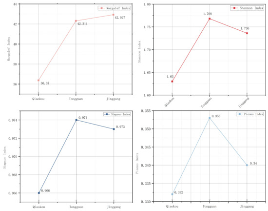
Figure 6.
Comparison of diversity indexes of different sample blocks.
The Shannon indices for all neighbourhoods are relatively high, indicating that while the spatial genetic diversity of traditional township neighbourhoods in Changsha exhibits a certain degree of richness, the overall level is not particularly outstanding. This phenomenon may be due to the relatively stable spatial structure formed in the long-term development of the traditional township blocks in Changsha. The cultural background of historical deposition and the diversified architectural types of traditional dwellings, ancestral halls, shops, and so on have increased the genetic diversity of the overall space of the block. In addition, due to the partial transformation or functional adjustment in the process of urbanization, some spatial elements have become homogeneous. Regarding the Shannon index, the highest value in Tongguan is attributed to the multifunctional space complex of production, storage, trade, and other functions generated by the ceramic industry, as well as the unique architectural forms formed by the cultural integration of northern and southern commercial groups. In addition, the Simpson index of each block shows no significant differences. The Pielou index of the block is also above the average level, indicating that the spatial gene distribution of traditional township blocks in Changsha is relatively uniform. This is due to the harmonious coexistence of multiple buildings formed throughout history and the prudent micro-transformation strategy adopted in the renewal of villages and towns.
4.3.4. Analysis of Spatial Gene Diversity Characteristics of Different Monomers
Table 8 shows that the Margalef index of monomer spatial genes is characterized by the coexistence of intra-level homogeneity and inter-level heterogeneity. The Margalef index of architectural monomer space is the highest, followed by node monomer space, and the street monomer space is the lowest. This shows the advantages of buildings with functional diversity. Node function reflects the characteristics of “structural existence but limited quantity” in traditional settlements; However, individual spaces in streets and alleys tend to be rather monotonous in terms of their functional characteristics. The highest Margalef index of a singular building space is mainly due to the compound functional structure formed by traditional settlements in the long-term natural evolution, and the organic coexistence of multiple functions such as residence, commerce, and religion. In contrast, the spatial index of street and lane type monomers is the lowest, which is mainly due to the morphological convergence phenomenon caused by its spatial characteristics, dominated by the traffic function. The spatial index of the node type monomer is in the middle position, which can be attributed to the fact that these landmark nodes, as the core carriers of the settlement’s public life, are indispensable in function, but restricted by construction regulations, use demand, and spatial hierarchy, so their types and quantities often follow the principle of “enough is enough.”
Table 8.
Monomer spatial gene diversity index.
The Shannon index of monomer space is quite different. The singular space of streets and alleys has the highest index, and religious space has the lowest. This shows that the alley in the traditional township block is an important space composed of streets and lanes. Religious space is strictly regulated by the traditional ritual system, and its stylized layout characteristics and unitary sacrificial function together lead to the lowest Shannon index. The highest index is for lane monomer space, which is mainly because it is a necessary path for the marketplace. In long-term use, it forms multiple naturally overlapping functions such as transportation, social networking, commerce, and trade, and its shape is flexible and adaptable to the terrain and residential layout, forming a wealth of topological variants. The Simpson index of each monomer space was not significantly different. However, the Pielou value varies greatly in each block. The Pielou index of a singular street, lane, or path space is higher, while that of a singular space for education and religion is lower. This shows that the singular spaces of streets and alleys are relatively evenly distributed in each block, while the singular spaces for education and religion are not. The reason for this is that the multi-functional compound characteristics of street and lane space promote a relatively balanced distribution of spatial genes. On the contrary, in singular spaces for education and religion, the intensive craftsman community formed by the ceramic industry has spawned the demand for large-scale education. This phenomenon is particularly prominent in the Tongguan block, where there are 5 educational buildings, while there are only 0-1 other similar blocks.
5. Discussion
5.1. Spatial Genetic Diversity Mechanism of Traditional Township Blocks in Changsha
5.1.1. Historical Function-Driving Mechanism of Spatial Genes
Modern urban blocks like the central urban area of Changsha focus more on high-strength composite, standardized, and modular construction in their functional layout. The spatial structure typically centers on transportation hubs, commercial clusters, and high-density residential areas. Due to their relatively young historical function and higher frequency of changes, spatial genes exhibit a higher “variability” rather than “heritability.” The spatial form of urban blocks reflects a “strategic reorganization” based on immediate functions, lacking a stable genetic chain formed by historical sedimentation as seen in traditional township blocks. This difference highlights the distinct characteristics of different settlement types in spatial gene expression pathways, further demonstrating the profound influence of historical functions on spatial gene inheritance patterns.
This study demonstrates that the spatial genetic diversity of traditional township blocks in Changsha is fundamentally shaped by the historical functions of the blocks through spatial gene analysis [49]. The results indicate that the Jinggang District leads in spatial gene types, loci quantity, and diversity indices, attributable to its historical functional positioning as a regional commercial hub during the Ming and Qing dynasties. This functional attribute not only defines the block’s spatial form but also enables hereditary inheritance and the development of spatial genes through long-term morphological updates and functional continuity. As a key transportation hub in the Xiangjiang River Basin, Jinggang has accumulated numerous composite functional spaces including docks, streets, and shops. These spatial forms, as “gene fragments,” have been continuously superimposed and replicated, and have evolved alongside historical changes, ultimately consolidating into highly stable and inheritable spatial genes.
The Tongguan District focuses on the ceramic industry, with its spatial gene composition is closely tied to multiple functions including production, warehousing, trading, and daily life, documenting the spatial logic of the traditional ceramic industry’s “production storage transportation chain. This functional continuity has promoted intergenerational replication and shaping of spatial genes in craft settlements, demonstrating strong genetic tendencies. In contrast, the Qiaokou neighborhood primarily engages in fishing and agriculture, representing typical characteristics of agricultural and fishery settlements. Its spatial structure revolves around the “water–land” interface, featuring a fishing port as the main functional node and forming a production sequence with drying and processing fields. Due to its functional simplicity and morphological uniformity, its spatial gene “genetic lineage” is relatively short, with a limited expression ability, leading to lower diversity levels.
These findings align with a study of the Dong ethnic songs in Huangdu Village, Tongdao Dong Autonomous County, Huaihua City, Hunan Province, China. This study points out that the cultural landscape genes of traditional villages are constantly produced and regenerated in the process of socio-economic development and cultural renewal, representing a process from prototype generation to structural reorganization and then to meaning restoration [50], essentially a process of “inheritance and mutation” of cultural genes. In addition, research on traditional villages in the central Guizhou region of China has also shown that the spatial genetic diversity of villages is closely related to their historical function [51]. This study additionally starts from the theoretical framework of “function–form” co-evolution and verifies that due to the differences in historical functional positioning, blocks have formed distinct spatial genetic characteristics and organizational patterns.
From this, it can be seen that the formation of spatial genes in traditional neighborhoods is not random, but the result of gradual solidification, replication, and continuation in the long-term historical functional evolution process, with significant dual characteristics of “historical functional driving+genetic accumulation,” reflecting the stability and intergenerational inheritance mechanism of spatial genes on the time axis.
5.1.2. The Hierarchical Distribution and Typological Structure of Spatial Genes
The distribution of spatial genes in traditional township blocks in Changsha shows a significant number of structural characteristics at different levels and spatial types [52]. By analyzing the number and importance values of genes, we found that the gene types in architectural space, street space, and square space are the most concentrated, and the locus expression is the most active. These spatial types constitute the backbone of the traditional block spatial system. Architectural space is particularly prominent, which fundamentally stems from its functional complexity and adaptability. Traditional architecture not only meets residential needs, but also often carries multiple functions such as commerce, handicraft production, and worship [53]. Compared to natural spaces, architectural spaces have higher diversity and complexity, which is consistent with the research findings on the architectural form of cultural transition zones in Shenzhen, Guangdong Province, China. This study suggests that the architectural form of cultural transition zones forms a stable spatial pattern through functional integration, with Jinggang’s “front store and back house” vertically integrated and Tongguan’s “workshop storage” horizontally integrated, reflecting the inheritance mechanism of adaptive spatial genes [54]. As important carriers of commerce and public activities, the layout, scale, and node characteristics of streets and squares have gradually stabilized over long-term use, accumulating rich spatial genes. The distribution of these spatial types in the block is closely related to functional requirements, reflecting the collaborative evolution characteristics of spatial genes in terms of function, form, and cultural needs. Relatively speaking, natural spaces such as water systems, forests, cultivated land, etc., are limited by the natural environment and have less human intervention, resulting in a single type of genetic composition. This distribution pattern of “artificial space enrichment and natural space sparsity” reflects the spatial construction logic of traditional settlements with human functions as the core, and demonstrates the hierarchical decreasing relationship of spatial structure from the core to the boundary, and from dense to sparse [39].
In summary, the hierarchical distribution and intensity of the expression of spatial genes in traditional neighborhoods are not accidental, but rather the result of systematic evolution under specific functional needs, social activities, and cultural practices. This distribution pattern exhibits the characteristic “function form” co-evolution, which conforms to the dynamic evolution law of spatial genes in cultural inheritance [55]. These analyses are closely related to the quantitative data used in this study, further verifying the evolutionary mechanisms of different spatial genes and emphasizing the hierarchical and complex nature of spatial genes.
5.1.3. Dual Relationship Between Diversity Characteristics and Spatial Conservation Strategies
This study reveals the dynamic coupling relationship between the genetic diversity of traditional township blocks in Changsha and contemporary spatial governance. Through diversity indices and quantitative analysis of gene distribution patterns, this study provides a systematic framework for quantifying the preservation status of blocks and evaluating how quantitative data inform protection and renewal strategies. These findings not only deepen our understanding of organic renewal mechanisms but also propose a new perspective of “genetic continuity governance,” offering theoretical support for the protection and renewal of traditional neighborhoods.
In terms of quantitative analysis, the use of diversity indices and spatial gene distribution patterns can objectively reveal the preservation of spatial genes in neighborhoods. The diversity indexes for the Jinggang, Tongguan, and Qiaokou blocks shows significant differences, which not only reflect the quality of gene preservation in different blocks but also the effectiveness of their respective protection mechanisms. The high level of diversity in the Jinggang District reflects the richness of historical and cultural resources and the effectiveness of policies such as the “Jinggang Historical and Cultural District Protection Plan.” The results indicate that the spatial genetic diversity index of the Jinggang block is significantly higher than that of Tongguan and Qiaokou, which is closely related to its profound historical resources and orderly protection policies.
Specifically, the “Jinggang Historical and Cultural Block Protection Plan” not only protects the diversity of spatial genes but also enhances their adaptability by systematically repairing and controlling traditional spatial structures. This successful case study is highly consistent with the research on the sustainable conservation of the Dujiangyan Historic and Cultural District in Chengdu, Sichuan Province, China.which jointly confirm the proposition that “institutional protection can activate the modern adaptability of historical space genes” [56]. The changes in the diversity index of the Jinggang block demonstrate how institutional protection can enhance the diversity and vitality of spatial genes by improving traditional spatial structures.
However, the preservation status of spatial genes in Tongguan and Qiaokou neighborhoods is not optimistic. The ceramic industry in Tongguan District is rich in cultural resources, but due to the impact of functional replacement and spatial transformation, its diversity index has decreased, and some traditional spatial structures have been destroyed, resulting in local homogenization of spatial genes. This phenomenon indicates that the lack or insufficiency of protective strategies, especially the contradiction between functional updates and spatial structure protection, has led to a decrease in spatial gene diversity. Due to the lack of clear protection mechanisms, traditional spatial elements in the Qiaokou block are gradually being lost, and the diversity of spatial genes has significantly degraded. The quantitative data of Qiaokou block further confirms that the lack of protection mechanisms will accelerate the degradation of spatial genes and significantly lower the diversity index of the block compared to other blocks.
Therefore, the quantitative data in this study not only reveal the current status of spatial genetic diversity in different neighborhoods, but also provide strong support for the development of more scientific and effective conservation strategies. Through the changes in the diversity indexes, we can objectively measure the effectiveness of conservation strategies and guide future spatial governance and renewal work [57]. For example, the successful experience of the Jinggang block shows that through systematic protection and adaptive renewal, the diversity of spatial genes can be effectively enhanced and their vitality can be continued. The cases of the Tongguan and Qiaokou neighborhoods demonstrate that the lack of protection and renewal strategies can lead to a sharp decline in spatial genetic diversity, affecting the historical value and cultural heritage of the neighborhoods.
In summary, this study emphasizes the application of quantitative data in spatial protection strategies. The quantitative analysis of diversity index and spatial gene distribution patterns provides a quantitative basis for formulating specific protection and renewal strategies. The combination of quantitative methods and qualitative discussions can help us more accurately identify the weak links in the protection of neighborhoods, and based on this, propose more targeted spatial governance suggestions. How to integrate contemporary functions while maintaining the texture of historical space has become a key issue in determining the evolutionary path of spatial genes [58]. Therefore, the proposal of the genetic continuity governance model emphasizes the dual role of numerical analysis of spatial diversity and spatial protection strategies, guiding the direction of future block protection and renewal [59,60].
5.2. Protection and Development Strategies of Traditional Township Blocks in Changsha
- (1)
- Establishment Of Spatial Gene Diversity Evaluation System
Given that the research results show that the Jinggang block has significantly more spatial gene types (164) and gene loci (54) than the Qiaokou block (136, 48) (Table 4), and its Margalef, Shannon, and other diversity indices are leading (Figure 6, Table 6), we recommend the following strategies:
By introducing the biodiversity index system into urban–rural spatial research, this study has made three breakthroughs in the theoretical framework of spatial genes: first, it innovatively constructs a township-scale “functional space gene unit” mapping model, and extends the traditional focus on the gene recognition of historical blocks in villages and cities to the weaker research field of the urban–rural transition zone; secondly, the disequilibrium coupling mechanism between the artificial space gene and the natural space base is revealed, and the theoretical hypothesis of “functional complexity drives gene diversity” is verified. At the same time, a diagnostic tool for spatial gene health based on quantitative indicators is developed to provide a universal paradigm for cross-scale cultural spatial sustainability assessment.
The identification of spatial genes is just the starting point of block protection. The more important thing is to build a scientific and dynamic evaluation system to quantitatively judge the diversity, integrity, and evolution trend of genes. Through the introduction of the Margalef index, Shannon index, Simpson index, Pielou evenness, and other biodiversity evaluation methods, a “spatial genetic diversity index system” suitable for traditional blocks can be established. Based on constructing the evaluation system of spatial genetic diversity of traditional towns in Changsha, it is necessary to formulate differentiated development strategies according to the characteristics of different types of blocks. The Jinggang block, as an important business hub in the Xiangjiang River Basin, should carry out the adaptive transformation of traditional buildings in combination with contemporary business needs, selecting 20 historical shops in the core sections along the river as the pilot, and realizing the functional regeneration of traditional space genes by implanting modern commercial facilities and digital display technology on the premise of maintaining the original building facade and structural system. For the Tongguan ceramic industry block, the complete production process space chain of “Longyao workshop yard” should be protected. It is suggested to adopt the “living museum” mode, select three well-preserved Ming Dynasty Longyao sites, and restore the traditional ceramic process. The protection strategy in the Qiaokou fishing and farming district needs to pay special attention to the repair and enhancement of “human–water” interaction genes. Given the degradation of traditional fishing port function caused by the change in the hydrological environment, it is suggested to implement “gradual micro-renewal.” Relevant studies have been preliminarily put into practice in the protection of traditional villages. For example, the spatial genetic diversity system of traditional villages proposed by Xiang and Xie has been proven to be able to be used to evaluate the degree of protection in villages and determine the priorities in updating them [27]. Therefore, the promotion of a spatial genetic diversity assessment system in traditional township blocks in Changsha can provide scientific support for the classification of cultural heritage, the priority of protection, and the depth of planning intervention.
- (2)
- Construction Of a Digital Spatial Gene Map Database
Based on the analysis in Section 4.1.2 and Section 4.2, architectural spatial genes have an absolute advantage in type richness (77 species), individual gene quantity (13,319), and comprehensive importance value (Figure 5a), and are the core carriers of the blocks’ spatial structure (Figure 7). To record and manage these core genes and their associated environmental elements in the system, we recommend the following:

Figure 7.
Spatial gene map of traditional township blocks in Changsha.
Against the background of the rapid development of information technology, the protection and renewal of traditional blocks need to rely on a digital platform to realize the visualization, retrievability, and dynamic update of spatial gene information [61]. It is suggested to take the block as the basic unit, integrate UAV aerial survey, remote sensing image, lidar 3D laser scanning, and other multi-source surveying and mapping technologies, and build a digital spatial gene map database integrating “geographic information–Architectural Structure–cultural semantics.” The database should cover the type attributes, functional evolution, historical age, and cultural value evaluation indicators of various gene loci, to realize the full life cycle management and real-time monitoring support of spatial genes. Based on the existing spatial gene recognition framework, this study systematically combed the multi-level spatial structure of traditional township blocks in Changsha, and constructed a spatial gene map including four levels of “node organization boundary external environment.” The atlas was developed as a central and radial structure, centered on the “core module of space gene,” and extends outwards to subsystems such as the architectural form, street network, boundary structure, and natural environment, and refines various spatial units such as street and lane organization, node space, gatehouse theater, memorial archways and ancestral halls, fields, mountains and waters, etc. The atlas identifies different spatial types and functional roles through color coding to enhance the visual expression effect and information recognition efficiency. The construction of the map aims to integrate the complex spatial form, historical evolution, and cultural gene characteristics of traditional blocks in Changsha. Through field research, literature analysis, and data visualization, the abstract spatial structure is transformed into a knowledge map with clear logic, complete semantics, and intuitive expression. This method not only helps to scientifically identify and classify key spatial genes, but also provides basic data support for cultural heritage protection, urban planning decision-making, and sustainable development paths, and significantly improves the practicability and dissemination of research results.
- (3)
- Implementation of the Dynamic Balance Protection Mechanism
The diversity analysis in Section 4.3 and the discussion in Section 5.1.3 indicate that Jinggang block maintains a high level of genetic diversity due to systematic protection (such as the “Jinggang Historical and Cultural Block Protection Plan”), while Tongguan and Qiaokou face the risk of genetic homogenization or degradation (Figure 6, Table 6). To address the differentiation of protection effectiveness, we recommended implementing the following:
The protection of traditional township blocks should not reaming in a static state, but should seek a dynamic balance between “protection renewal” [62]. For different gene categories and spatial levels, the protection strategies should reflect the differences and adaptability. For high-value genes such as architectural space, we should focus on the survival of the Hunan regional characteristic genes. For the typical “front store and back house” style shops and buildings in the Jinggang block, the special “triple eaves” facade structure should be protected, which is the key gene that should be adapted to the local rainy climate. The internal reconstruction needs to strictly control the Bay modulus and retain the spatial sequence of “front store–middle yard–back house.” Tongguan’s ceramic workshop buildings should especially be protected to maintain its unique “Longyao dependent” spatial layout, which is a necessary spatial condition to ensure the traditional ceramic production process can continue. For the medium importance genes such as street nodes and Menfang Square, a “micro renewal” strategy should be promoted. Street space protection should highlight the linear characteristics of commercial blocks. The protection of Jinggang’s main street should strictly maintain the traditional width of 7-9 m, and the pavement should adopt the unique local bluestone slab and rubble mixing technology. Tongguan industrial streets and alleys should retain their unique “Y” shaped bifurcation layout, which is the historical spatial layout that was used to meet the needs of pottery transportation. The renewal of square spaces should reflect their functional specificity. The reconstruction of Jinggang wharf square needs to retain its trapezoidal plane and three-level platform elevation difference, which is a typical gene that should be adapted to the change in the Xiangjiang River water level. Natural space restoration should strengthen regional adaptability. The restoration of the Qiaokou fishing port water system should adopt the local unique “fir pile+block stone” revetment technology, which has been proven in Xiangjiang River flood control in the long term. At the same time, it is necessary to protect the unique spatial gene “catch and sun farm” along the coast. At the same time, a block-level “spatial gene change monitoring system” should be established to regularly record and evaluate the disappearance, substitution, and derivation of spatial genes, to ensure the synchronous evolution of protection measures and block development, and form a sustainable and dynamic mode of cultural heritage governance.
- (4)
- Limitations
Although the interdisciplinary application of biodiversity indexes (Margalef, Shannon, Simpson, Pielou) in spatial genetic diversity evaluation has expanded the dimension of quantitative analysis, the conceptual alignment between ecology and built environment research still needs to be strengthened. Biodiversity indexes mainly depict systematic relationships in organic life, while the diversity of architectural types is essentially the hierarchical expression of cultural practice in time and space. Its cultural function value has not been fully analyzed in the current index framework, which is mainly manifested in the limitation of the representation of morphological statistical characteristics on deep social semantics.
The dependence of spatial gene recognition on UAV aerial data may introduce multi-dimensional bias. The inherent characteristics of the top-view angle, dense canopy, narrow roadway, and building shelter easily lead to incomplete recognition of ground features, affecting the integrity statistics of gene units. At the same time, it is difficult for orthogonal images to fully capture the height difference between the fine elevation of the building and the complex terrain, which weakens the depth of analysis of the building shape gene. In addition, a single aerial photograph only reflects the instantaneous spatial state, and it is difficult to dynamically capture the impact of temporary spatial function changes, such as festivals, on gene expression.
In terms of the quantification of intangible cultural elements, although the existing framework indirectly represents the intangible reality through the functional space, deeper dimensions such as the cultural connotation, practice frequency, and community identity of the spatial ritual of dragon boat sacrifice, the production of ceramic handicrafts, and the use of fishing songs on public nodes lack an accurate mapping of a systematic quantitative path and morphological indicators, which may lead to a deviation in the gene importance assessment. Future research needs to integrate multi-temporal remote sensing, three-dimensional laser scanning, and ethnographic surveys, and build a correlation model of material and non-cultural elements to improve the evaluation system.
6. Conclusions
Taking Jinggang, Tongguan, and Qiaokou as empirical objects, this study constructed a spatial gene recognition framework, systematically analyzed the number, importance, and diversity of spatial genes, and revealed their distribution and evolution mechanism. The study found that the formation of a block space gene was driven by historical functions, and commercial blocks such as Jinggang showed a high richness in gene types and loci. However, the gene expression of single-function blocks such as Qiaokou is limited, showing a clear “history–function–space” linkage mode. At the same time, the spatial genes of different types and levels show a differentiation pattern. Artificial spaces such as buildings, streets, and squares are enriched and diverse due to their complex functions, while natural spaces are relatively stable and singular in type, forming the structural characteristics of “artificial space dominating, natural space complementing.” In addition, the diversity of spatial genes is also significantly affected by contemporary governance strategies. Jinggang has been able to retain complete gene pedigree due to system protection planning, Tongguan has been partially homogenized due to modern development, and Qiaokou has a trend of gene degradation. Based on the above findings, this paper proposes three strategies, including the construction of a diversity evaluation system, a digital gene map database, and a dynamic protection mechanism, to provide a scientific basis and a path for the protection and sustainable renewal of traditional street cultural heritage. The introduction of spatial gene methodology enriches traditional block research’s theoretical system and provides a data basis and technical means for multi-scale spatial governance practice.
Author Contributions
Conceptualization, P.C., Y.G., M.X.; data curation, P.C., Y.G., M.X.; formal analysis, P.C., Y.G., M.X.; funding acquisition, Y.G.; investigation, P.C.; methodology, P.C., Y.G., M.X.; project administration, Y.G.; resources, P.C., Y.G., M.X.; software, P.C., Y.G., M.X.; supervision, P.C., Y.G., M.X.; validation, P.C., Y.G., M.X.; visualization, P.C., M.X.; writing—original draft, P.C., Y.G., M.X.; writing—review and editing, P.C., Y.G., M.X. All authors have read and agreed to the published version of the manuscript.
Funding
This research received no external funding.
Institutional Review Board Statement
Not applicable.
Informed Consent Statement
Not applicable.
Data Availability Statement
The datasets generated and analyzed during the current study are not publicly available due to their use in projects that have not yet been completed but are available from the corresponding author on reasonable request.
Conflicts of Interest
The authors declare that they have no known competing financial interests or personal relationships that could have appeared to influence the work reported in this paper.
References
- Mukherjee, S. The Gene: An Intimate History; Scribner: New York, NY, USA, 2016. [Google Scholar]
- Conzen, M.R.G.; Denecke, D.; Shaw, G. Urban Historical Geography; Cambridge University Press: Cambridge, UK, 1988. [Google Scholar]
- Liu, S.; Wu, L.; Xiang, C.; Dai, W. Revitalizing Rural Landscapes: Applying Cultural Landscape Gene Theory for Sustainable Spatial Planning in Linpu Village. Buildings 2024, 14, 2396. [Google Scholar] [CrossRef]
- Zhou, J.; Xia, X.; Wu, S. Genetic Characteristics Evaluation and Planning Design of Traditional Village Cultural Landscape: Taking Dongmen Fishing Village in Xiangshan, Zhejiang Province as an Example. J. Asian Archit. Build. Eng. 2024, in press. [Google Scholar] [CrossRef]
- Jiang, Y. Identify Space Gene: Deal with the Phenomenon of All Cities with Similar Urban Form. Des. J. 2022, 2, 25. [Google Scholar] [CrossRef]
- Dong, J.; Shang, H.; Yin, H. Semantic Network Analysis of Spatial Gene Sequence in Dabaodao Neighbourhood. J. Asian Archit. Build. Eng. 2024, 24, 1999–2016. [Google Scholar] [CrossRef]
- Duan, J.; Shao, R.; Lan, W.; Liu, J.; Jiang, Y. Space Gene. Urban Plan. J. 2019, 43, 14–21. [Google Scholar]
- Shao, R.; Duan, J.; Jiang, Y.; Qian, Y.; Wang, L. Spatial Genes: A New Approach to Promote the Locality of Overall Urban Design. Planner 2020, 36, 33–39. [Google Scholar]
- Guo, Q. Research on the Architecture and Culture of Hunan and Jiangxi Folk Houses. Ph.D. Thesis, South China University of Technology, Guangzhou, China, 2002. [Google Scholar]
- Yin, L.; Liu, P. Type Expression and Spatial Differentiation of Planar Prototype Genes of Traditional Dwellings in the Xiangjiang River Basin. Geogr. Res. 2023, 42, 2191–2210. [Google Scholar]
- Wu, Q. Urban Water Systems in Ancient China. Cent. China Archit. 1991, 35, 55–61. [Google Scholar]
- Zhang, Z.; Dou, Y.; Liu, X.; Gong, Z. Multi-hierarchical Spatial Clustering for Characteristic Towns in China: An Orange-based Framework to Integrate GIS and Geodetector. J. Geogr. Sci. 2023, 33, 618–638. [Google Scholar] [CrossRef]
- Ye, L.; Wang, H.; Wu, Z.; Lin, Z. Spatiotemporal Matching of Population Density and Distribution of Public Service Facilities in the Urban–Rural Interface Under Rapid Urbanization: A Case Study of Luzhi Town in Suzhou, China. J. Urban Plan. Dev. 2025, 151, 05025009. [Google Scholar] [CrossRef]
- Du, X.; Shi, D. Rural Heritage: Value, Conservation and Revitalisation—From the Perspective of the Human-Land Relationship. Built Herit. 2019, 3, 1–6. [Google Scholar] [CrossRef]
- Xiang, H.; Xie, M.; Fang, Y. Study on the Architecture Space-Social Network Characteristics Based on Social Network Analysis: A Case Study of Anshun Tunpu Settlement. Ain Shams Eng. J. 2024, 15, 102333. [Google Scholar] [CrossRef]
- Jiang, Y.; Li, Y.; Duan, J. Identification and Extraction Pathways of Spatial Genes. Urban Plan. J. 2025, 1, 18–24. [Google Scholar] [CrossRef]
- Zhang, Z.; Wang, X. Identification and Extraction of Spatial Genes in Traditional Villages of Aoki River. J. Northwest Univ. Nat. Sci. Ed. 2025, 55, 420–437. [Google Scholar] [CrossRef]
- Fan, J.; Zheng, B.; Zhang, B.; Huang, Z.; Liu, J. Research on the Revitalization Path of Ethnic Villages Based on the Inheritance of Spatial Cultural Genes—Taking Tujia Village of Feng Xiang Xi in Guizhou Province as a Case Study. Sustainability 2023, 15, 1303. [Google Scholar] [CrossRef]
- Zhang, Y.; Huang, Z. Genetic Characteristics of Spatial Network Structures in Traditional Bouyei Village Architecture in Central Guizhou. Sustainability 2025, 17, 1435. [Google Scholar] [CrossRef]
- Nie, Z.; Li, N.; Pan, W.; Yang, Y.; Chen, W.; Hong, C. Quantitative Research on the Form of Traditional Villages Based on the Space Gene—A Case Study of Shibadong Village in Western Hunan, China. Sustainability 2022, 14, 8965. [Google Scholar] [CrossRef]
- Zhang, W.; Yang, H. Quantitative Research of Traditional Village Morphology Based on Spatial Genes: A Case Study of Shaanxi Province, China. Sustainability 2024, 16, 9003. [Google Scholar] [CrossRef]
- Braun, A.; Warth, G.; Bachofer, F.; Schultz, M.; Hochschild, V. Mapping Urban Structure Types Based on Remote Sensing Data—A Universal and Adaptable Framework for Spatial Analyses of Cities. Land 2023, 12, 1885. [Google Scholar] [CrossRef]
- Liu, L.; Song, Q.; Wang, X. Spatial Morphology Evolution of Rural Settlements in the Lower Yellow River Plain: The Case of Menggang Town in Changyuan City, China. Land 2023, 12, 1122. [Google Scholar] [CrossRef]
- Xi, J.; Wang, X.; Kong, Q.; Zhang, N. Spatial Morphology Evolution of Rural Settlements Induced by Tourism. J. Geogr. Sci. 2015, 25, 497–511. [Google Scholar] [CrossRef]
- Hoffman-Hall, A.; Loboda, V.T.; Hall, V.J.; Carroll, M.L.; Chen, D. Mapping Remote Rural Settlements at 30 m Spatial Resolution Using Geospatial Data-Fusion. Remote Sens. Environ. 2019, 233, 111386. [Google Scholar] [CrossRef]
- Lan, W.; Li, J.; Wang, J.; Wang, Y.; Lei, Z. Cultural Diversity Conservation in Historic Districts via Spatial-Gene Perspectives: The Small Wild Goose Pagoda District, Xi’an. Sustainability 2025, 17, 2189. [Google Scholar] [CrossRef]
- Xie, M.; Xiang, H.; Huang, Z. Study on the Spatial Genetic Diversity of Traditional Villages under the Construction of Land Transportation. J. Railw. Sci. Eng. 2023, 20, 2708–2717. [Google Scholar] [CrossRef]
- Zhang, X.; Zhou, L.; Zhou, T. Quantitative Analysis of Spatial Gene in Traditional Villages: A Case Study of Korean Traditional Villages in Northeast China. J. Asian Archit. Build. Eng. 2024, in press. [Google Scholar] [CrossRef]
- Milojković, A.; Antić, U.; Stanojević, A.; Jevremović, L.; Nikolić, M.; Đorđević, I.; Brzaković, M. Perception of Authenticity of a UNESCO Heritage Site: New Infill Design and Integrity Protection in the Old Town of Ohrid, North Macedonia. Sustainability 2025, 17, 2067. [Google Scholar] [CrossRef]
- Zhang, Y.; Chen, S.; Hoistad, M.A. Sustainable Development Strategy for Historic Neighborhood Shrinkage: Taking Puhuiquan Neighborhood in Yulin, China, as an Example. Herit. Sci. 2024, 12, 67. [Google Scholar] [CrossRef]
- Wang, J.; Zakaria, S.A. Morphological Characteristics and Sustainable Adaptive Reuse Strategies of Regional Cultural Architecture: A Case Study of Fenghuang Ancient Town, Xiangxi, China. Buildings 2025, 15, 119. [Google Scholar] [CrossRef]
- Mei, J.; Zheng, W. Ideas and Paths of Thematic Transformation of Traditional Urban Blocks. Planner 2016, 32, 82–86. [Google Scholar]
- Zhang, L. Spatial Reconstruction of Small Town Characteristics from the Perspective of Spatial Production: A Case Study of the Spatial Design of Stone Archway Block in Jiuxiang Town, Hanyuan County. Rural Econ. 2015, 9, 100–103. [Google Scholar]
- Lou, S.; Chen, Y.; Feng, J.; Zhang, L. Reconstruction of Rural Cultural Space and Planning Based on the Perspective of “Social-Spatial” Theory: A Case Study in Zhuma Township, Zhejiang Province. Buildings 2025, 15, 671. [Google Scholar] [CrossRef]
- Wen, B.; Burley, J.B. Expert Opinion Dimensions of Rural Landscape Quality in Xiangxi, Hunan, China: Principal Component Analysis and Factor Analysis. Sustainability 2020, 12, 1316. [Google Scholar] [CrossRef]
- Lei, C. Research on Tourists’ Cultural Perception of Zhoucun Ancient Commercial Town Historic and Cultural Block. Acad. J. Humanit. Soc. Sci. 2024, 7, 210–218. [Google Scholar]
- Zhang, S.; Wang, C. Value Reconstruction of Historical and Cultural Blocks from the Perspective of Business, Tourism and Cultural Integration: Models and Paths. J. Bus. Econ. 2024, 21, 57–60. [Google Scholar]
- Tang, H.; Liu, X.; Li, J.; Wang, H. Study on the Conservation and Renewal of Traditional Rural Tourism Spaces: A Perspective Based on Tourists’ Revisit Intention. J. Clean. Prod. 2025, 499, 145184. [Google Scholar] [CrossRef]
- Xiang, H.; Qin, Y.; Xie, M.; Zhou, B. Study on the “Space Gene” Diversity of Traditional Dong Villages in the Southwest Hunan Province of China. Sustainability 2022, 14, 14306. [Google Scholar] [CrossRef]
- Huang, Y.; Huang, Y.; Chen, Y.; Yan, Y.; Zheng, L.; Ying, Z. Interpretation of the Jiangnan Landscape and Countryside (Shan-Shui) Pattern: Evidence from the Classification and Spatial Form of Traditional Settlements in the Nanxi River Basin. Buildings 2025, 15, 413. [Google Scholar] [CrossRef]
- Wang, S. Analysis of the Spatial Hierarchy of Traditional Chinese Settlements. Ph.D. Thesis, Tianjin University, Tianjin, China, 2012. [Google Scholar]
- Watt, A.S. Pattern and Process in the Plant Community. J. Ecol. 1947, 35, 1–22. [Google Scholar] [CrossRef]
- Hopkins, B. Pattern in the Plant Community. J. Ecol. 1957, 45, 451–463. [Google Scholar] [CrossRef]
- Hu, Z.; Strobl, J.; Min, Q.; Tan, M.; Cheng, F. Correction to: Visualizing the Cultural Landscape Gene of Traditional Settlements in China: A Semiotic Perspective. Herit. Sci. 2021, 9, 128. [Google Scholar] [CrossRef]
- Wilson, J.B.; Gitay, H.; Steel, J.B.; King, W.M. Relative Abundance Distributions in Plant Communities: Effects of Species Richness and of Spatial Scale. J. Veg. Sci. 1998, 9, 213–220. [Google Scholar] [CrossRef]
- Mouillot, D.; Leprêtre, A. A Comparison of Species Diversity Estimators. Res. Popul. Ecol. 1999, 41, 203–215. [Google Scholar] [CrossRef]
- Margalef, R. On Certain Unifying Principles in Ecology. Am. Nat. 1963, 97, 357–374. [Google Scholar] [CrossRef]
- Strong, W.L. Biased Richness and Evenness Relationships within Shannon–Wiener Index Values. Ecol. Indic. 2016, 67, 703–713. [Google Scholar] [CrossRef]
- Yong, F.; Xiang, J. Spatial Gene Extraction and Regional Overall Protection of Traditional Villages. In Urban Construction and Management Engineering IV; CRC Press: Boca Raton, FL, USA, 2024; pp. 1076–1084. [Google Scholar]
- Yang, L.; Hu, Y.; Wu, X.; Hu, J. Cultural Landscape Gene Production Process and Mechanism of Dong Traditional Village: A Case Study of Huangdu Village. J. Nat. Resour. 2023, 38, 1164–1177. [Google Scholar] [CrossRef]
- Zhao, M.W. Study on Spatial Genetic Diversity of Traditional Villages in Guizhou. Master’s Thesis, Guizhou University, Guiyang, China, 2020. Available online: https://link.cnki.net/doi/10.27047/d.cnki.ggudu.2020.001624 (accessed on 15 June 2025).
- Yu, C.; Zhou, Z.; Gao, J.; Zhang, X.; Zheng, Q.; Liu, Z.; Ma, Z.; He, W.; Wen, S. Multi-Scale Comparison of the Formation Mechanisms in Landscape Genes of Traditional Villages. Sci. Rep. 2025, 15, 4126. [Google Scholar] [CrossRef]
- Li, B.H.; Li, Z.; Liu, P.L.; Dou, Y.D. Landscape Genetic Variation and Differentiation of Traditional Villages in the Xiangjiang River Basin. J. Nat. Resour. 2022, 37, 362–377. [Google Scholar]
- Jin, T.; Youjia, C.; Geng, L.; Dawei, X.; Huashuai, C.; Jiaping, H. Juxtaposition or Integration: The Formation Mechanism of Architectural Form in a Cultural Transition Zone. J. Asian Archit. Build. Eng. 2023, 22, 2690–2703. [Google Scholar] [CrossRef]
- Cao, K.; Liu, Y.; Cao, Y.; Wang, J.; Tian, Y. Construction and Characteristic Analysis of Landscape Gene Maps of Traditional Villages along Ancient Qin-Shu Roads, Western China. Herit. Sci. 2024, 12, 37. [Google Scholar] [CrossRef]
- Kou, H.; Zhou, J.; Chen, J.; Zhang, S. Conservation for Sustainable Development: The Sustainability Evaluation of the Xijie Historic District, Dujiangyan City, China. Sustainability 2018, 10, 4645. [Google Scholar] [CrossRef]
- Zhou, H.; Liu, W.Y.; Gong, Y.; Huang, Z.S. Spatial Gene Diversity Analysis of Dong Traditional Villages in Southeast Guizhou. Guizhou Ethn. Stud. 2020, 41, 99–104. [Google Scholar] [CrossRef]
- Ge, H.; Wang, Z.; Bao, Y.; Huang, Z.; Chen, X.; Wu, B.; Qiao, Y. Study on Space Diversity and Influencing Factors of Tunpu Settlement in Central Guizhou Province of China. Herit. Sci. 2022, 10, 85. [Google Scholar] [CrossRef]
- Bura, P.; Ando, T. Evaluation of the Orobua Settlement as a Historical Heritage in West Sulawesi, Indonesia. J. Asian Archit. Build. Eng. 2022, 22, 1582–1597. [Google Scholar] [CrossRef]
- Atmanti, F.P.; Uekita, Y. Preserving Tradition: The Role of Community Customs and Sustainable Practices in Traditional House Preservation on Nias Island, Indonesia. J. Asian Archit. Build. Eng. 2024, 1–21. [Google Scholar] [CrossRef]
- Lan, W.; Chen, J.; Duan, J.; Li, J. Convergence, Mining, and Application: A Data Collaboration Framework for Spatial-Gene Research and Practice. Buildings 2024, 14, 3824. [Google Scholar] [CrossRef]
- Hu, L.; Liu, T.; Deng, J.; Yu, X.; Liao, S.; Shen, K. The Importance, Performance Analysis and Improvement of Township Traditional Market Environment Based on Behavioural Demand—Taking Taoyuan County Market in Hunan Province as an Example. J. Asian Archit. Build. Eng. 2023, 23, 1500–1517. [Google Scholar] [CrossRef]

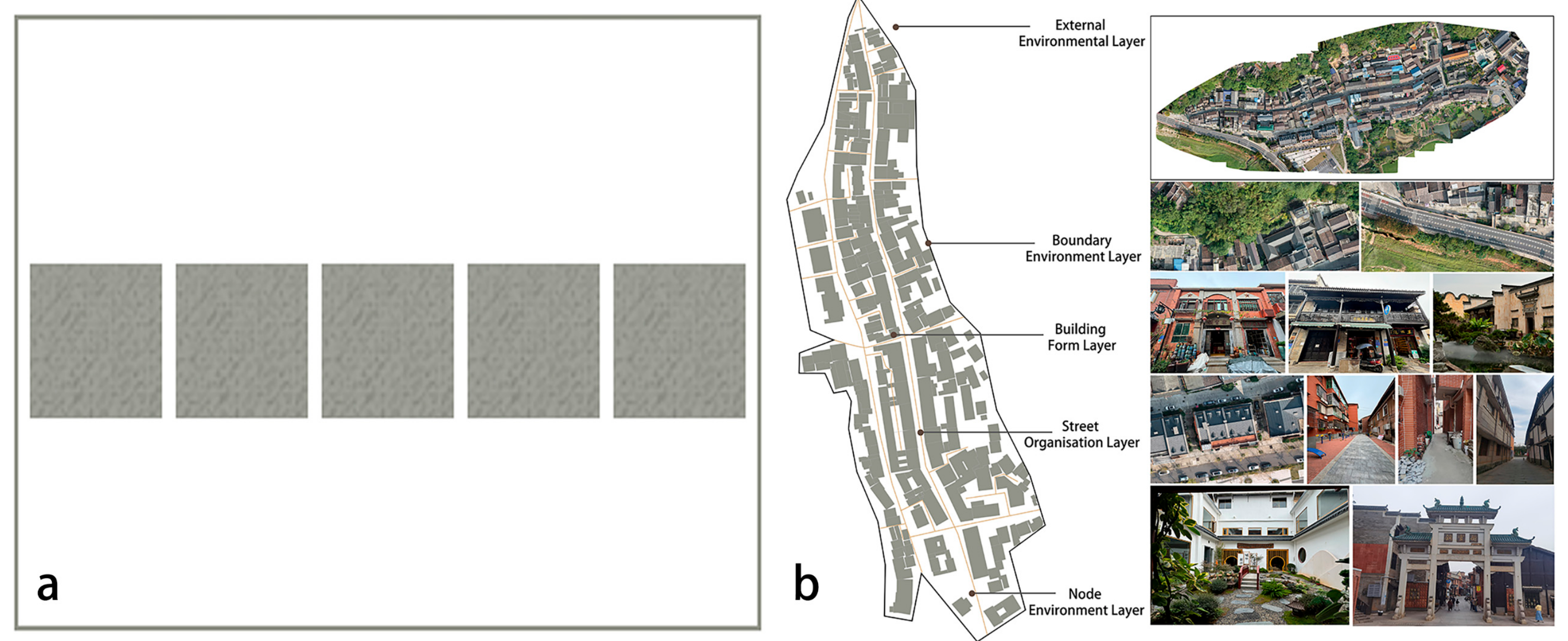
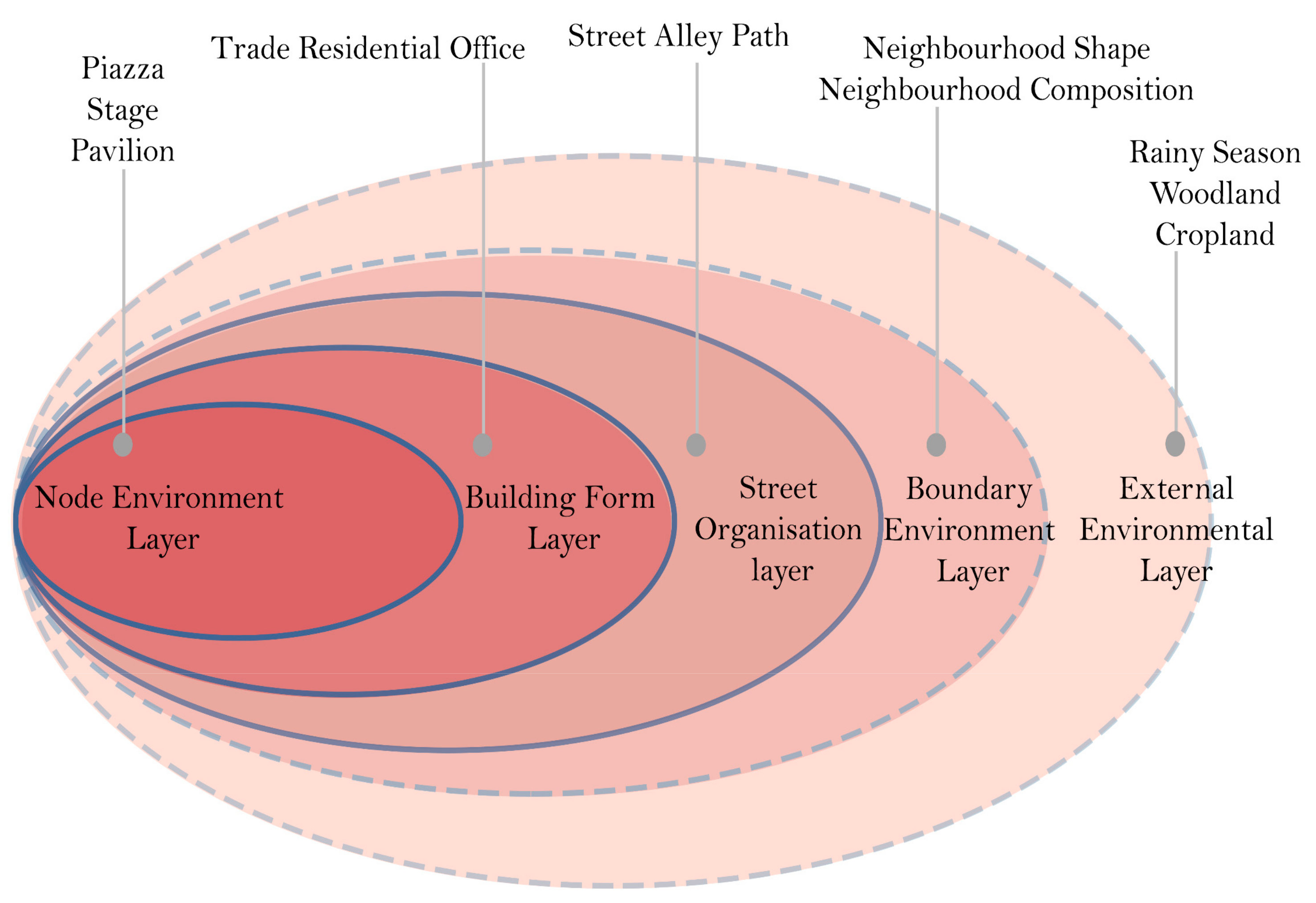
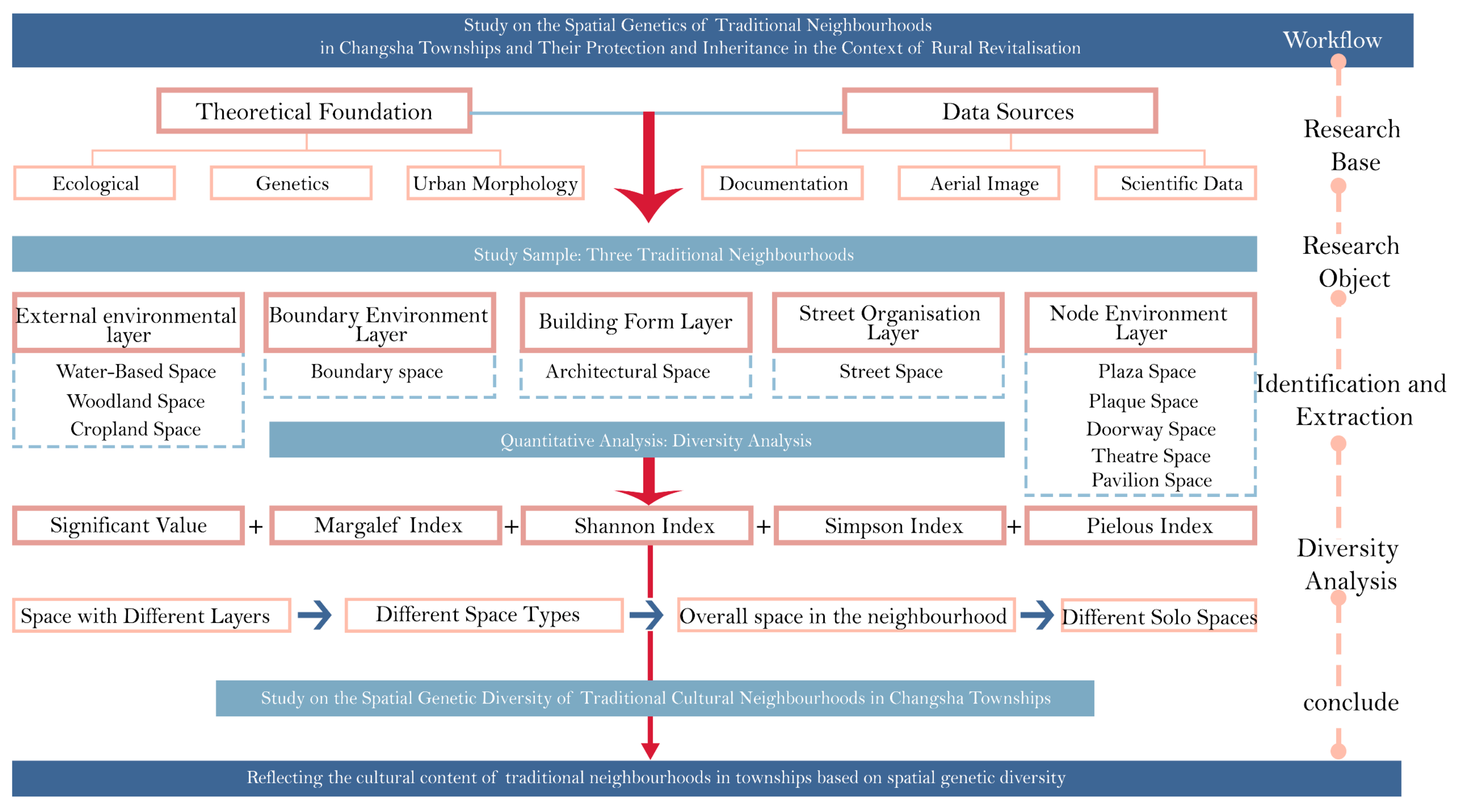
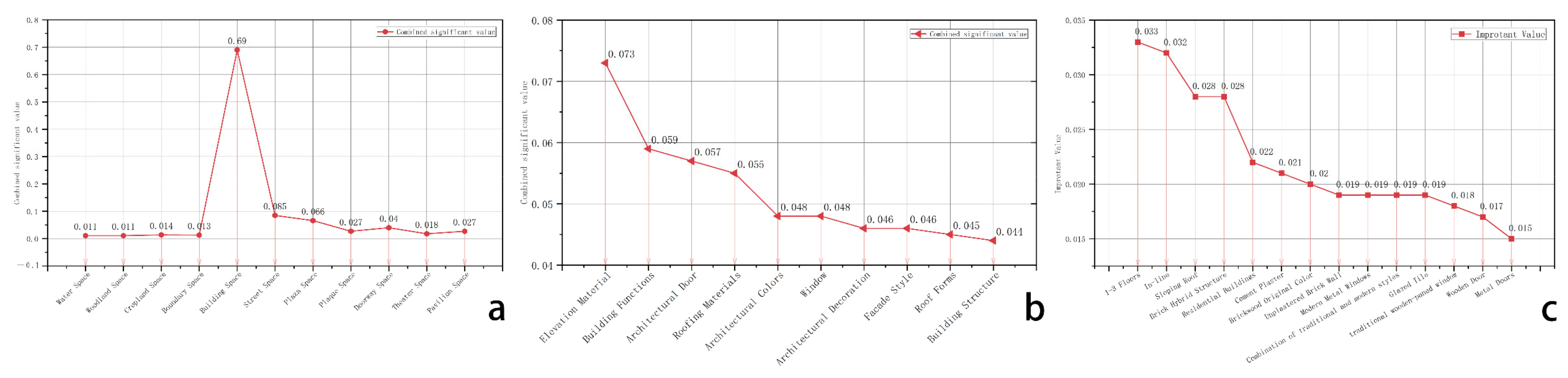
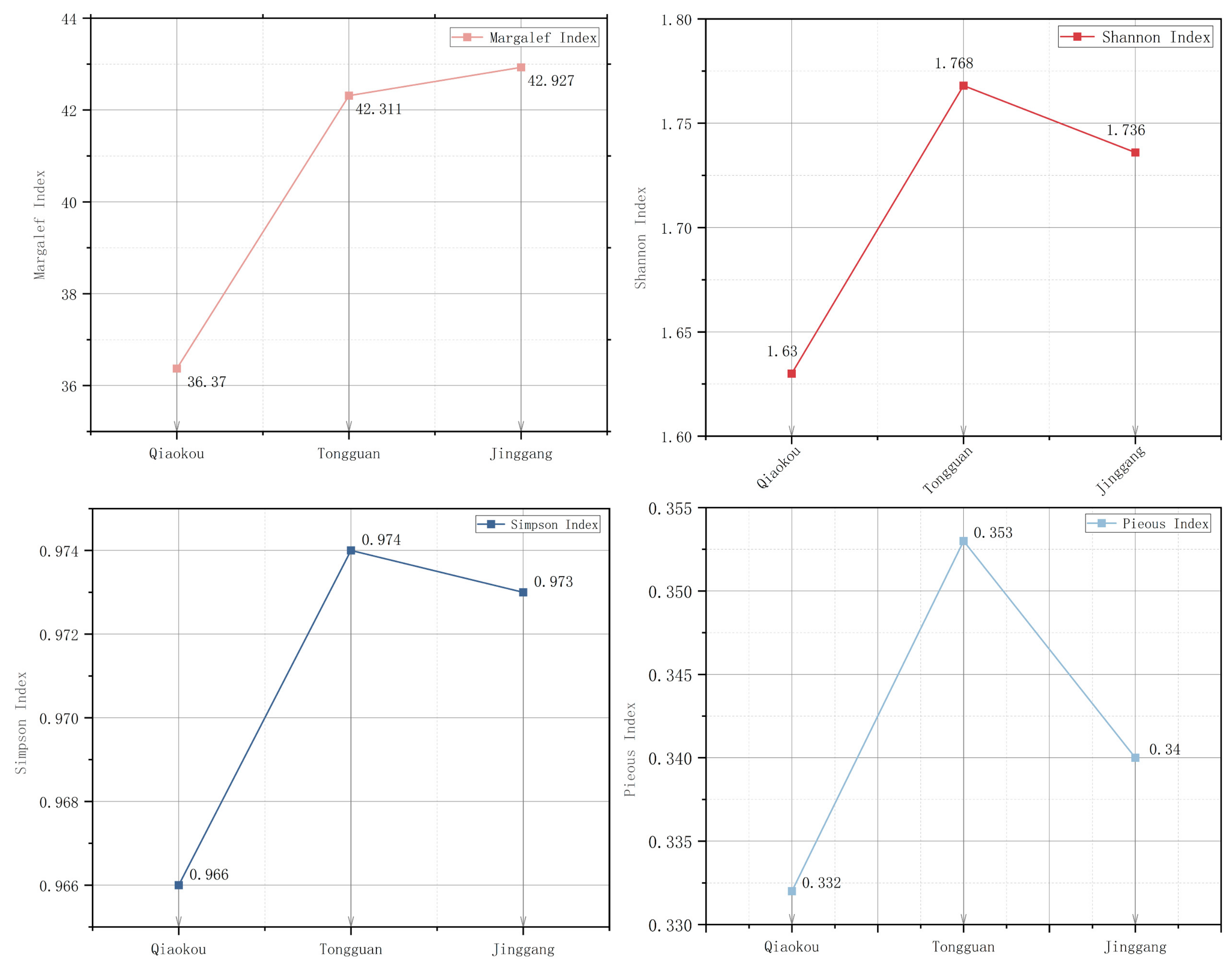
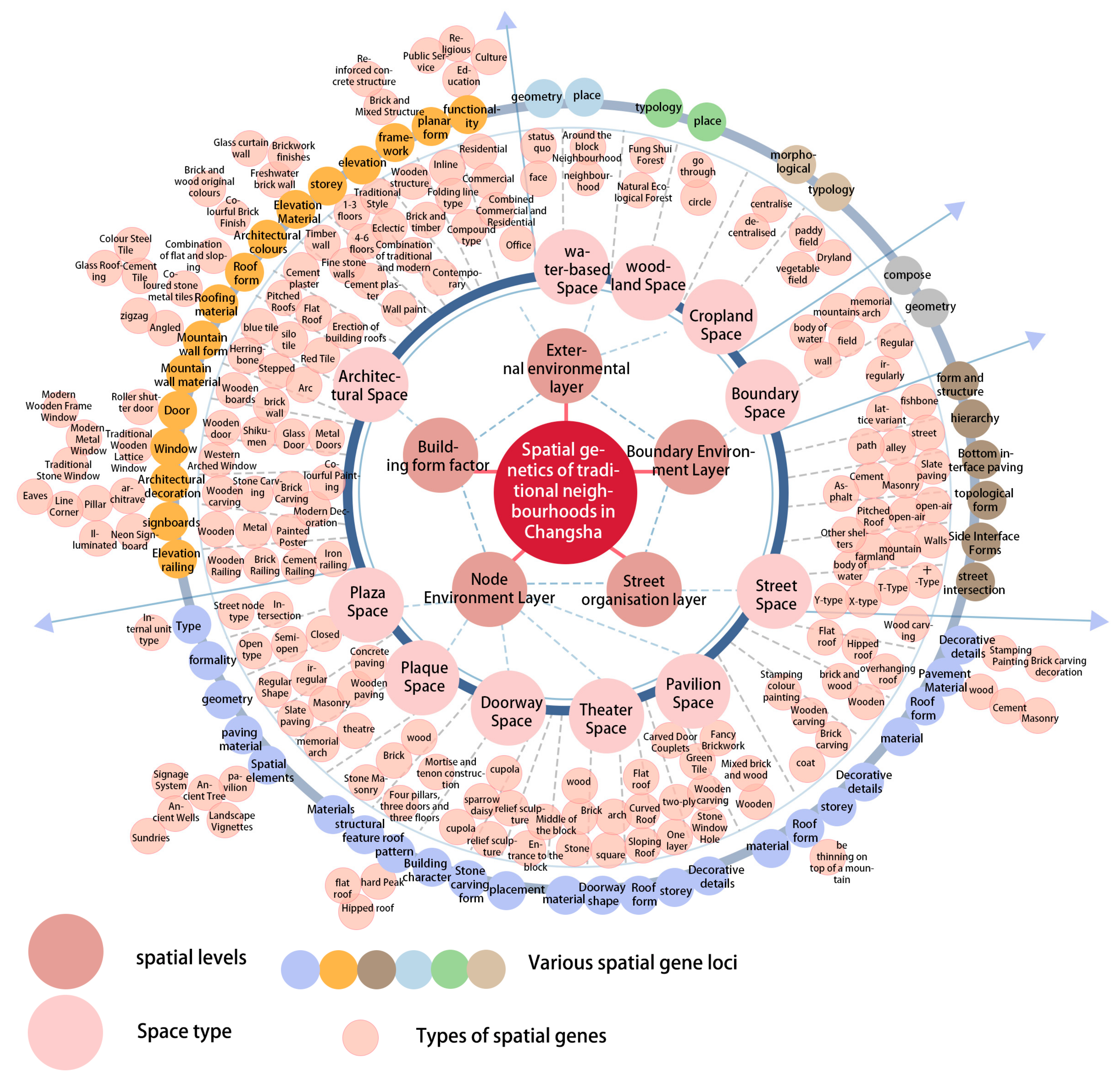
Disclaimer/Publisher’s Note: The statements, opinions and data contained in all publications are solely those of the individual author(s) and contributor(s) and not of MDPI and/or the editor(s). MDPI and/or the editor(s) disclaim responsibility for any injury to people or property resulting from any ideas, methods, instructions or products referred to in the content. |
© 2025 by the authors. Licensee MDPI, Basel, Switzerland. This article is an open access article distributed under the terms and conditions of the Creative Commons Attribution (CC BY) license (https://creativecommons.org/licenses/by/4.0/).