1. Introduction
The world is characterised by the growing volumes and flow of goods [
1], which are primarily driven by the proliferation of e-commerce [
2,
3] and international trade [
4]. Hesse and Rodrigue [
5] argue that the fundamental consideration in this contemporary economic environment pertains not only to the nature, origin, and destination of freight but also to how freight is moved and stored across different geographical scales, underscoring the significance of logistics. Central to the vitality of cities [
6], logistics processes play an essential role in facilitating the flow of goods between points of origin and consumption globally [
1,
7]. The logistics industry encompasses, inter alia, transportation, warehousing, handling, circulation, processing, and delivery of goods [
8]. Tare et al. [
9] argue that the growing geographical separation between production and consumption activities has resulted in a higher demand for logistics. Therefore, a well-integrated and efficient logistics sector can boost economic competitiveness and, in toto, augment economic development [
10,
11]. Jaller, Zhang, and Qian [
12] warn that although freight, a crucial component of logistics, is important for economic development, it also induces emissions, noise, congestion, and other negative externalities, which adversely affect the sustainability of cities.
Historically, logistics was the subject of analysis in various disciplines or fields of study, including operations management, marketing management, engineering, and management accounting [
13]. Notably, after being relatively overlooked by human geography and associated fields of study, Hesse [
14] acknowledges that the geography of logistics has recently gained well-deserved scholarly attention. Numerous studies accordingly provide insights into the locational patterns of logistics facilities, and, in some cases, the factors driving those patterns. The interest in the geography or locational patterns of logistics facilities is exemplified by a strong focus in the literature on the notion of logistics sprawl and its multifaceted ramifications. As relevant individual empirical and review publications are too numerous to list, Special journal editions, like Dablanc and Browne [
15], exemplify the widespread interest in logistics sprawl.
Despite the increasing scholarly interest in logistics, there is a relative lack of research analysing logistics facilities real estate patterns and trends. This analysis can offer insights for informing the development of spatial planning policies and strategies for placing logistics facilities within cities and broader regions. As emphasised by He et al. [
16], when deciding the optimum location of logistics nodes, spatial planners and relevant stakeholders should comprehensively understand and consider the impact of, among others, land rent. To extend the literature, the paper aims to analyse the patterns and trends of the market value of land used for logistics facilities or activities within the City of Cape Town municipality, South Africa. The market values are analysed against the municipality’s spatial structure/organisation, transport infrastructure, urban development policy initiatives, and fiscal incentives. As discussed further in the Background Section, these are some of the main factors influencing the placement of logistics facilities. Rodrigue [
17] posits that the concept of spatial organisation has two dimensions: on the one hand, there is an element of spatial differentiation, which denotes the characteristics of, among others, location, size, and density of a certain phenomenon; and on the other, there is a notion of spatial interactions, referring to the attributes of places of origin and destination. Transportation significantly impacts spatial organisation by structuring space at various scales, and also, conversely, space shapes transport, reflecting a reciprocity between the two elements [
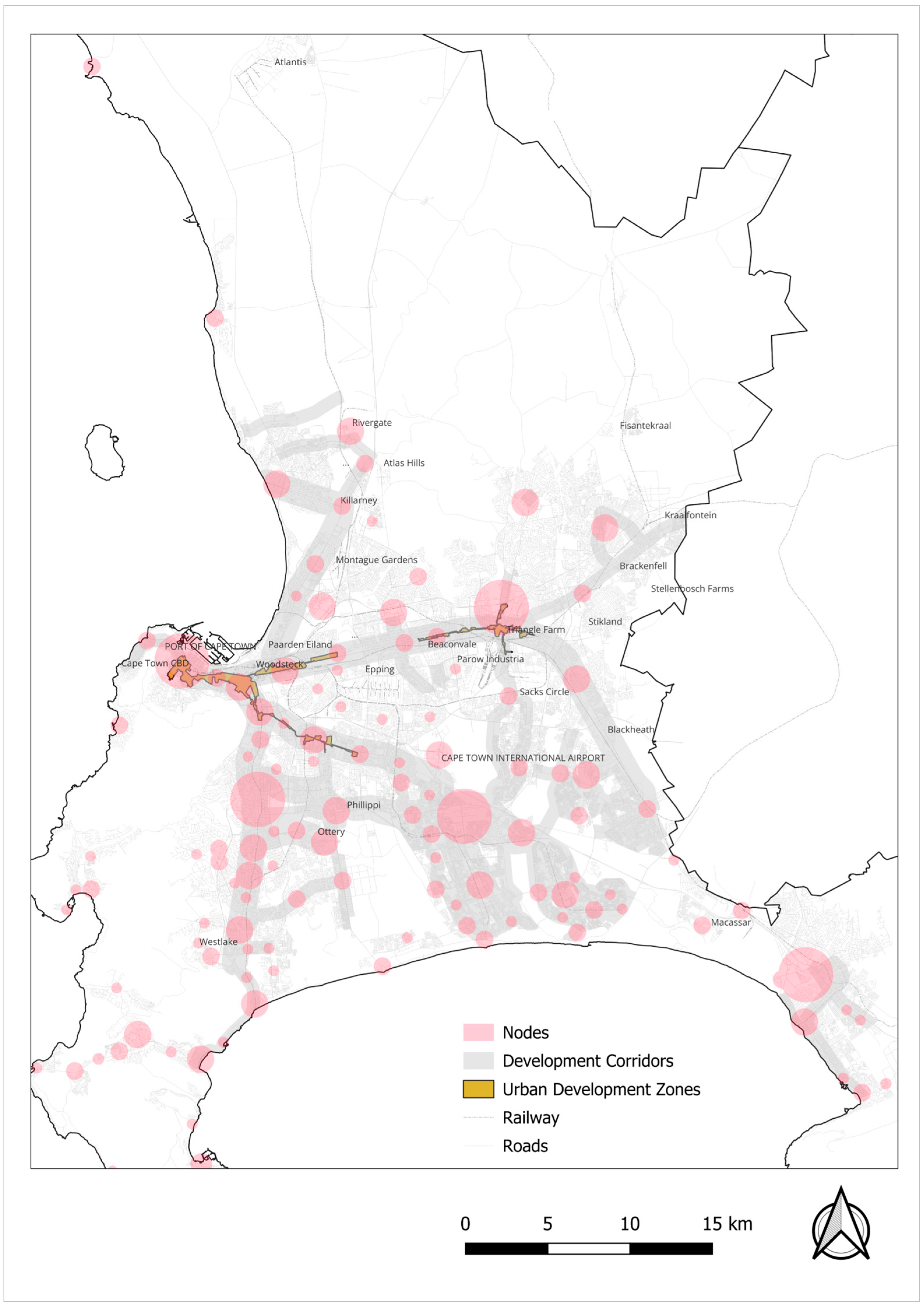
17]. The paper focuses largely on the connections between land value and spatial structure and transport infrastructure due to this fundamental reciprocity. Furthermore, the urban development policy initiatives and fiscal incentives explored in the paper also hinge on accessibility (see the Methods Section). Against this backdrop, the study tested the following null hypothesis: there is no positive relationship between the market value of land accommodating logistics facilities and proximity to the airport, seaport, CBD, development corridors, major intersections, development nodes, railway stations, and urban development zones.
The paper’s contribution is three-fold: first, it provides property value-related insights for strategically informing the spatial distribution of logistics facilities; secondly, it offers a methodological contribution for developing a database of land accommodating logistics facilities in the context of a lack of dedicated geo-spatial logistics-related data; and thirdly, it contributes to the application of geographically weighted regression (GWR) modelling to logistics research. The remainder of the paper is structured as follows:
Section 2 provides an overview of the literature to contextualise the study.
Section 3 details the research design and methods adopted to test the null hypothesis and achieve the overarching study’s aim.
Section 4 presents the findings.
Section 5 discusses the findings relative to the literature.
Section 6 concludes the paper.
5. Discussion
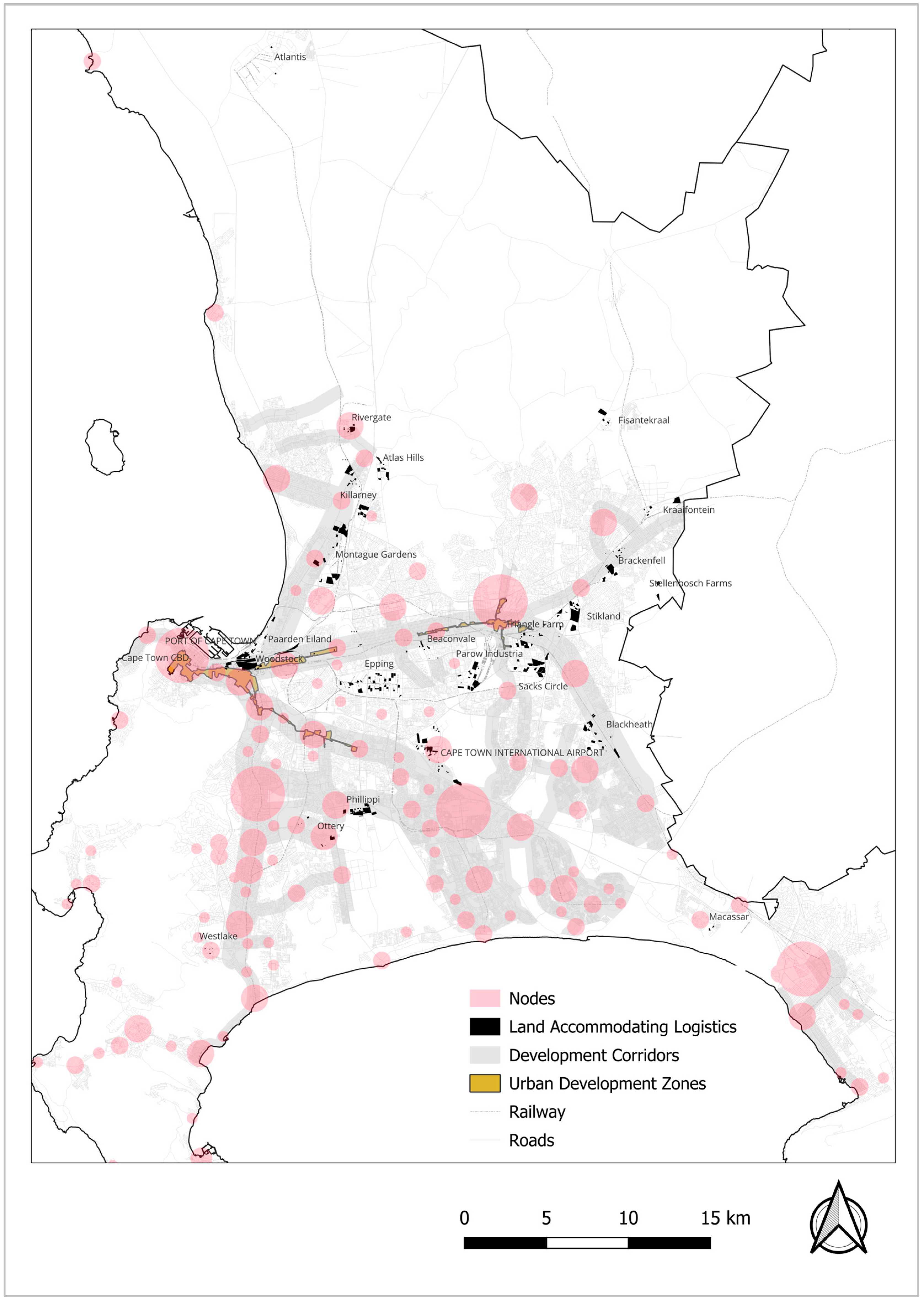
Reflecting a close connection between the City of Cape Town’s industrial/manufacturing landscape and logistics facilities placement, the findings presented in the previous section showed that the land parcels accommodating logistics facilities or activities were predominantly in the industrial areas, with a limited number in the Cape Town CBD. The largest number of land parcels were in the vicinity of the airport, the seaport, and major road infrastructure. The land parcel with the highest market value was in the Montague Gardens/Milnerton industrial area, valued at ZAR 604 million in 2018 and a staggering ZAR 712 million in 2022. The area is in one of the most accessible zones in the municipality, positioned near the junction of two national roads, the N1 and N7, and approximately 10 km to the Port of Cape Town, 14 km to the Cape Town CBD, and 19 km to Cape Town International Airport. In the 2000s, Montague Gardens was recorded as the fastest-growing industrial area in the City of Cape Town since 1985 [
52]. The findings attest that the area has managed to attract investment, significantly impacting market land values and continuing the trend from the 1980s.
In terms of the average market value, the Cape Town CBD had the highest average of ZAR 99,037/m
2 in 2018 and ZAR 98,814/m
2 in 2022, which appeared to be an extreme outlier compared to the rest of the industrial zones, economic nodes, or neighbourhoods in the municipality. This finding aligns the work of Rai et al. [
29], who argued that higher levels of service for urban goods delivery are now required, overcoming the high cost of operating freight facilities in dense urban environments like city centres [
29]. Given the comparatively high market values in the CBD, it is essential to mention the nature of the logistics facilities within the two land parcels in the area: one is a service point for a multinational shipping company, and the other is a collection point for an e-commerce provider. Both of these facilities are located within mixed-use multi-storey buildings.
Paarden Eiland, near to and largely contiguous with the Port of Cape Town, had the third-highest average of ZAR 5606/m
2 in 2018 and ZAR 6505/m
2 in 2022, albeit it did not have properties with the highest overall value. This, in part, shows that the land parcels in Paarden Eiland are relatively small. The area is positioned in a unique or prime zone in the vicinity of the seaport and about 4 km from the Cape Town CBD and proximate to the N1 national road. Notably, in 1996, Paarden Eiland had a prime industrial rental rate about three percent higher than the municipal average [
53]. The area appears to have maintained relatively high property market values or rent, specifically average values as per the study’s findings.
Previous research has acknowledged that major transport infrastructure nodes such as Cape Town International Airport and the Port of Cape Town attracted warehousing development from the 1990s [
54], as also reflected by the high number of land parcels identified in this study. However, unlike the environs of the port that stood out in terms of the average values, the market values in the vicinity of the airport did not stand out, either at the highest or lowest end of the spectrum. The land parcel with the highest value near the airport was at ZAR 256 million in 2018 and ZAR 312 million in 2022. The highest average value was, however, relatively more noteworthy at ZAR 5108/m
2 in 2018 and ZAR 5960/m
2 in 2022.
In 2018, the land parcels with the lowest average value were ZAR 313/m
2 in Blackheath, and ZAR 330/m
2 in 2022 in Atlantis. As noted by Grant, Carmody, and Murphy [
55], Atlantis came into existence as a so-called new town in the 1970s, which was planned to be, among others, a significant future industrial zone beyond the city. Despite the various forms of investment put into Atlantis, the area has not reached the expectation of attracting major industrial establishments [
55]. In the context of logistics, this is reflected in the low average market values above. Regarding other zones with low average values, historically, in 1979, Blackheath was characterised by an industrial structure dominated by the production of non-metallic minerals and fabricated metal products [
54].
Across the different industrial or logistics clusters in the City of Cape Town municipality, there was a drop in the values of some land parcels between 2018 and 2022, albeit an increase was experienced at an aggregated level across the nodes and neighbourhoods. The drop can, at least in part, be attributed to the impact of COVID-19 on property values. Notably, the study’s findings did not support the literature arguing that the value of logistics facilities, particularly warehousing, significantly increased during the COVID-19 era.
From the study’s findings, a discernible pattern identified is that, unlike areas with road-based accessibility and, to some extent, seaport and airport, zones near the railway stations, such as Woodstock, Blackheath, Parow Industria, and Goodwood, did not stand out in terms of the market property values, particularly averaged per the land parcel extent.
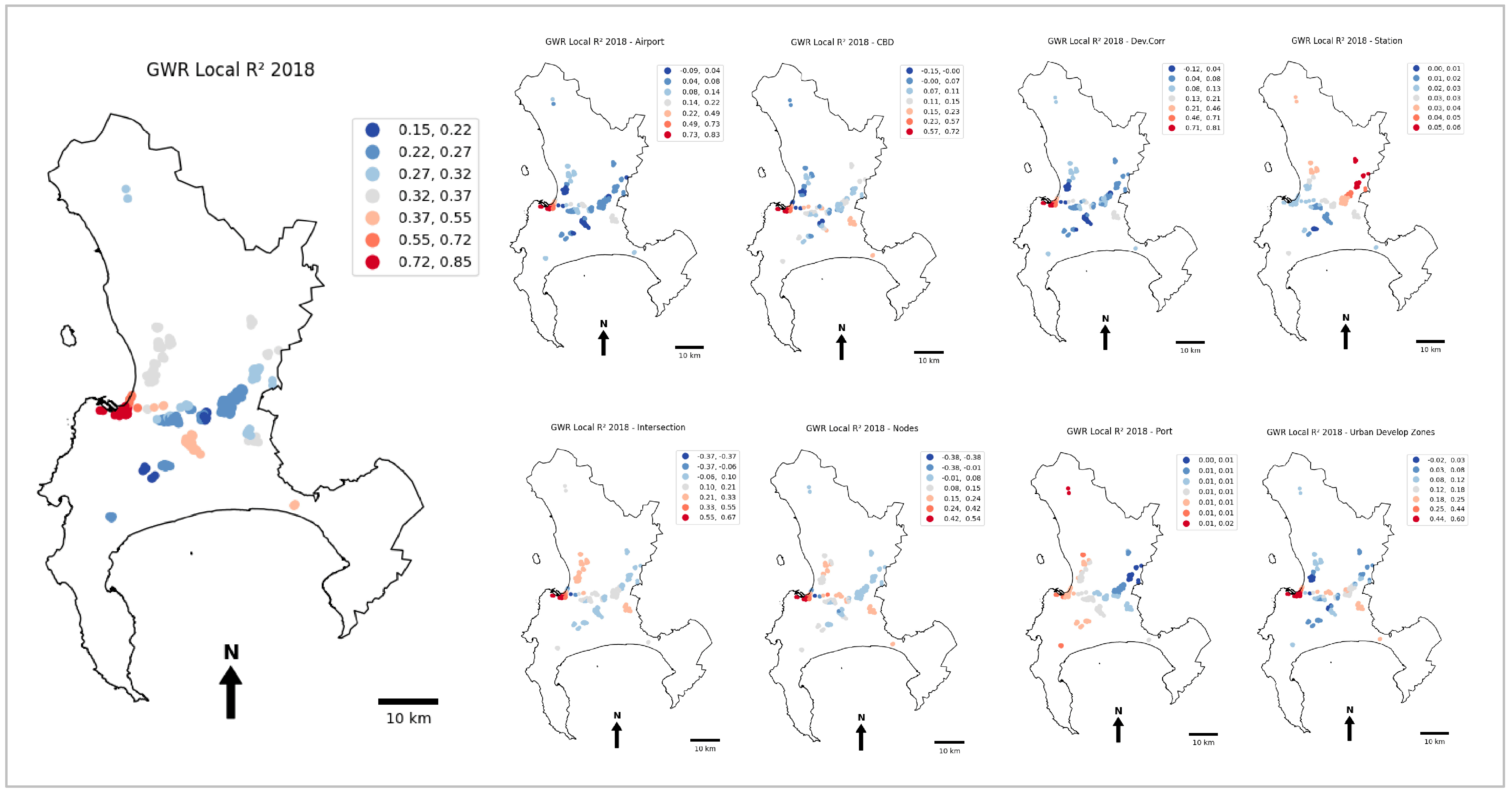
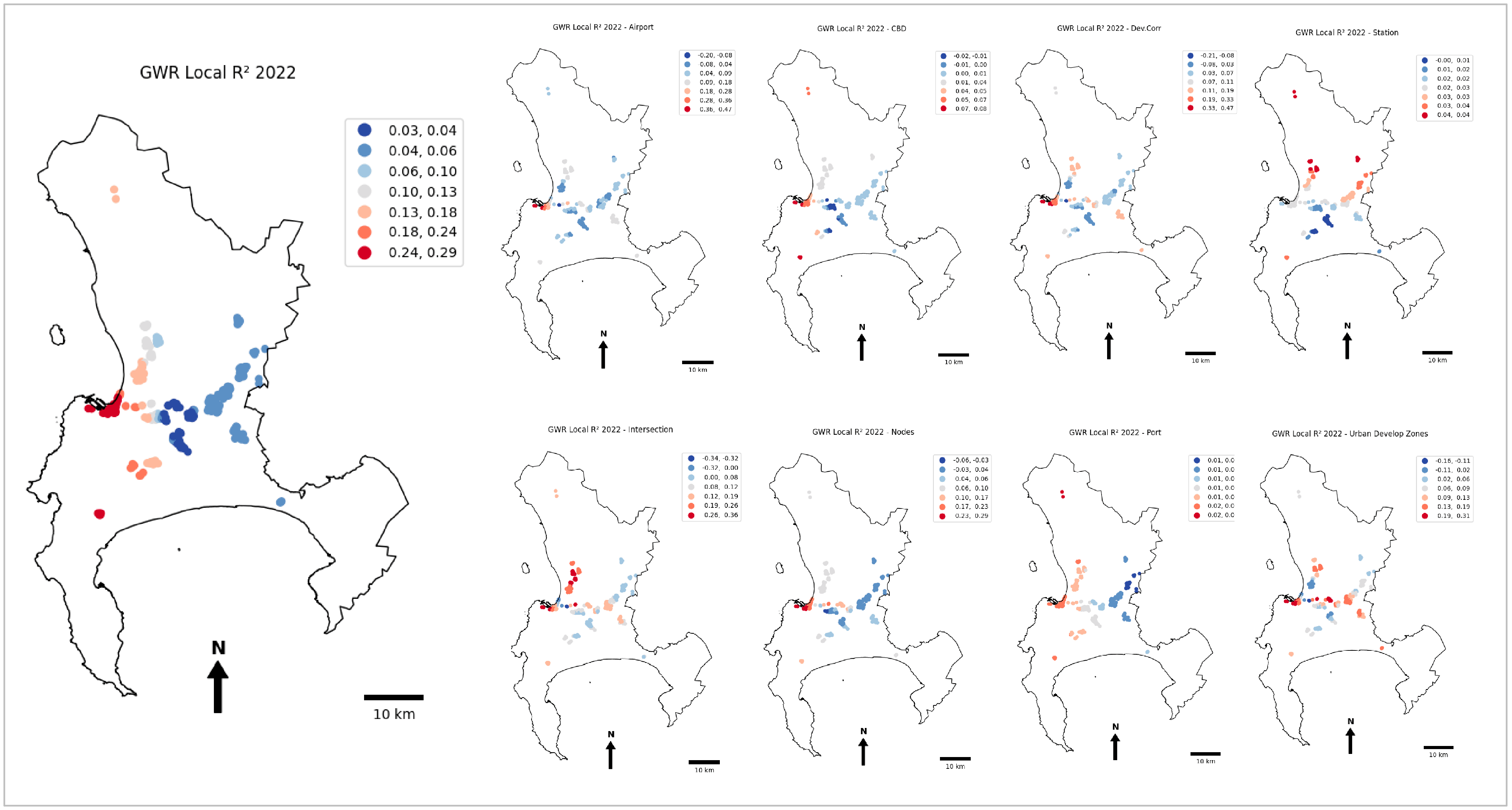
More telling findings came from the geographically weighted regression model, which yielded weak relationships between the 2018 and 2022 property market values of land accommodating logistics facilities and proximity to the CBD, nearest train station, Cape Town International Airport, major intersections, Port of Cape Town, economic nodes, development corridors, and urban development zones. These are some of the factors that the literature highlights as influential in the location choice of logistics facilities. However, partially rejecting the null hypothesis that there was no positive relationship between the dependent and independent variables, the
p-values for the airport, CBD, development corridors, and seaport were statistically significant in both 2018 and 2022. Major intersections, development nodes, railway stations, and urban development zones were not statistically significant. Given the inconclusive
p-value and R-squared results, the findings did not provide sufficient evidence of the positive impact of the location attributes on the property market value of land accommodating logistics facilities in the City of Cape Town municipality. It is, therefore, argued that the findings highlight the disconnect between the placement of logistics facilities and spatial planning efforts in the municipality. This aligns with the findings of Mokhele and Fisher-Holloway [
54], who discovered that warehousing and distribution were not explicitly mentioned in the planning policy, and spatial planners did not understand the significance and dynamics of logistics processes in the contemporary economy. The geographical patterns of logistics facilities appear to be left mainly to an invisible hand, which, however, is not in sync with crucial locational attributes across the municipality.
6. Conclusions
This explorative paper analysed the patterns and trends of property market values of land parcels accommodating logistics facilities in the City of Cape Town municipality, South Africa. Using the 2018 and 2022 secondary data collated by the municipality through mass valuation processes, it was observed that most land parcels accommodating logistics facilities were within the so-called industrial areas, with a limited number within the dense city centre area. It was found that land parcels in the Cape Town CBD and the vicinity of the Port of Cape Town had the highest average market value, while the property with the highest market value was located in the neighbouring Montague Gardens/Milnerton. These areas are in the highly accessible sections of the municipality, with, among others, easy access to the N1 and N7 national roads. The zones near the railway line across the municipality did not portray high values (with Blackheath reflecting some of the lowest averages) compared to those with just road-based accessibility. Although the market values in the airport’s environs did not stand out either at the highest or lowest end of the spectrum, they were still noteworthy compared to the other zones analysed. In an attempt to provide a detailed interpretation of the patterns, it was found that, overall, despite the statistical significance of some locational attributes, weak relationships existed between the market value of land accommodating logistics facilities and accessibility, fiscal incentives, and spatial planning initiatives in the municipality.
In light of the study’s findings, it is recommended that relevant stakeholders strategically integrate logistics into spatial planning to improve efficiencies by promoting logistics in areas that the policy prioritises for investment. Specifically, it is recommended that the use of rail freight be revitalised in the municipality. This would potentially attract significant investment to the new and existing logistics hubs with railway access, such as the environs of Belcon inland port (in the vicinity of Parow Industrial) and Blackheath. In turn, the municipality would reap the economic benefits in terms of the rates or taxes based on market property values, while, most importantly, promoting sustainable logistics processes within the municipality. This revitalisation will be crucial in reducing logistics costs and, accordingly, averting the negative environmental impacts of logistics processes, particularly the externalities from the over-reliance on trucks for freight delivery.
As largely explorative, the paper has several limitations that warrant further research on the connections between property market values and the placement of logistics facilities:
Firstly, the analyses were aggregated at the land parcel level, wherein, in some cases, a single parcel accommodated multiple establishments, logistics- and non-logistics-related. Further research could, therefore, establish if there are differences in the market value of mixed-use premises compared to those used exclusively for logistics purposes;
Secondly, and relatedly, the analysis did not consider the heterogeneity of logistics facilities within the land parcels analysed. Therefore, future research could investigate the connections and relationships between different types of logistics facilities or logistics spaces and property market values;
Thirdly, further research is required to establish a tailor-made valuation approach for land accommodating logistics facilities. This would address the potential shortcomings of the mass valuation data relied upon by this study, and thereby improving the robustness of the knowledge on the relationship between locational attributes and the market value of land accommodating logistics facilities.
