1. Introduction
For several decades, water managers have been studying the impact of forests on watershed dynamics in order to develop more sustainable forest and water management strategies. Early research conducted in humid environments found an inverse relationship between tree canopy and streamflow [
1]. These findings were verified with measurements of streamflow changes after forest disturbances and controlled experiments dealing with deforestation [
2]. The main drivers of this inverse relationship have been identified as reduced evaporation of water beneath the tree canopy and increased transpiration from vegetation [
3]. These findings led to a general consensus that an increase in tree canopy coverage will likely result in a net loss of water contributing to storage and overland flow within watersheds. However, recent studies have found that a decrease in forest cover in arid and semiarid environments has led to more variable responses of streamflow [
4,
5,
6,
7].
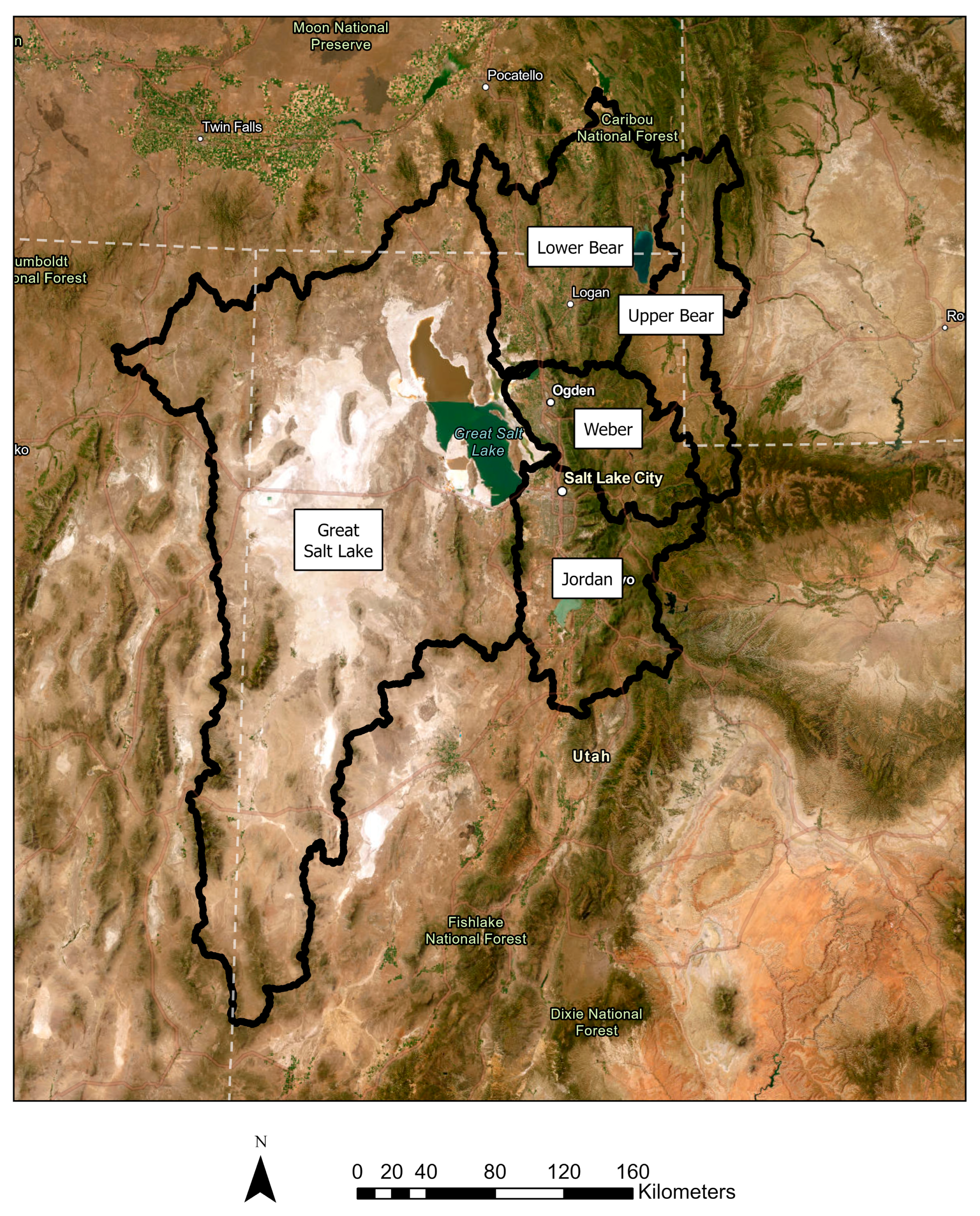
The Great Salt Lake Basin, located in the Intermountain Western United States, is a semiarid watershed covering approximately 93,000 square kilometers and supports 2.5 million people (
Figure 1). Around 95% of the water in this region comes from wintertime precipitation in an accumulating snowpack [
8]. The Great Salt Lake, the terminal lake for water in this basin, has been in decline since the early 1980s, reaching its historical low in January 2022. The lake has lost two-thirds of its surface area and three-quarters of its water supply in that time. Drivers of this water loss include rising temperatures attributed to climate change, unsustainable human consumptive water use such as agriculture and irrigation, and a chronic meteorological drought in the area [
9].
In an effort to create greater streamflow to recover water levels in the Great Salt Lake, community leaders have been exploring tree thinning as a possible solution [
10]. Tree thinning is the process of removing trees from a forest to open canopy gaps for sunlight, water, and nutrient inputs (
Figure 2). Based on the general consensus between tree canopy coverage and streamflow, proponents of the solution believe that removing tree canopy will contribute greater streamflow to the Great Salt Lake. However, as the Intermountain West is a semiarid environment, this relationship is not explicitly defined and may lead to greater variability in streamflow response than expected. For example, Goeking and Tarboton [
4] found that tree thinning leads to variable responses in several arid and semiarid watersheds in the Western United States, and even reduced water availability when the tree canopy was completely removed.
Since 95% of the watershed’s streamflow is produced from snowpack [
12], examining the relationship between forest cover and snowpack in the Great Salt Lake watershed is an important first step in discovering the impact of tree thinning on water availability. This is due to the additional influence of tree canopy on snowpack in montane environments. Dense forest canopies intercept falling snow, reducing snowpack up to 60% of what would exist otherwise [
13]. On average, mid-winter losses of snowpack through sublimation and evaporation are around 15–40% [
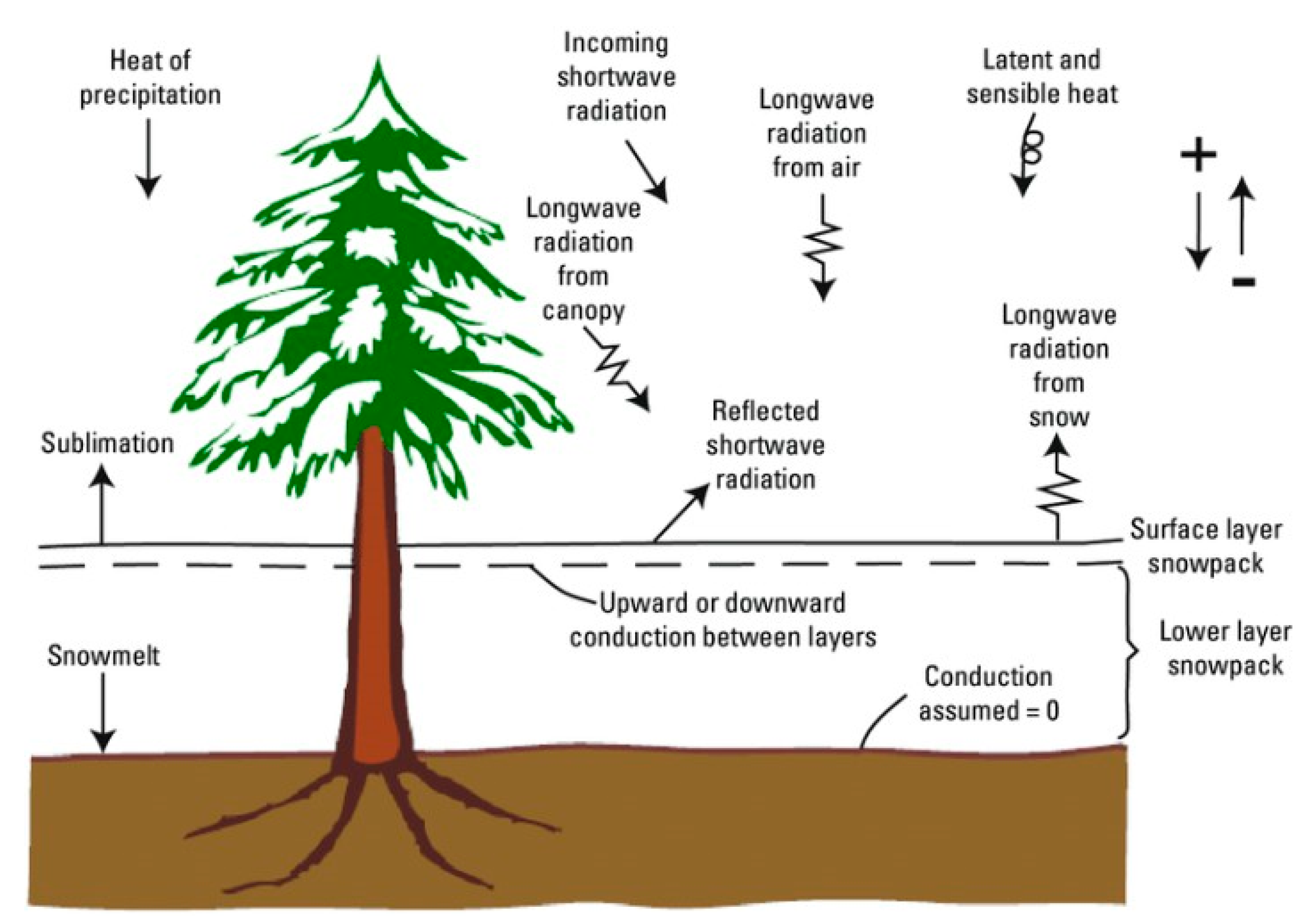
14]. However, vegetation can also protect snowpack from solar radiation. This increase in shade boosts snowpack quantity and decreases the rate of melt [
15]. These variable effects on snow water equivalent make predicting snowpack response to tree thinning highly uncertain [
3] (
Figure 3). Even further, other studies have shown these competing processes are dampened by solar insolation, latitude, and topography [
16]. Thus, controls must be placed on each of these variables to create an effective analysis of tree canopy’s effect on snowpack.
The snowpack’s response to tree canopy change can be examined through post-fire analysis, as wildfire events provide ideal disturbances that mimic the process of tree thinning. Maxwell and St. Clair concluded that burn severity can greatly alter peak snowpack accumulation within montane snow environments [
18]. This is facilitated by reducing forest canopy density and allowing more snowfall to reach the forest floor. The competing processes of snowpack shading and snowpack interception have been shown to be mediated by topography such as elevation, slope, and aspect [
16]. However, a watershed-level analysis of these factors has not been conducted for the Great Salt Lake watershed.
The objective of this research is to model the relationship between tree canopy coverage and snowpack to assess the viability of tree thinning as a solution to improve peak snow water equivalent in the Great Salt Lake watershed. This relationship will be defined for the October 2001 to September 2023 period, a span of 22 years that encompasses most of the lake’s decline. The analysis of these factors will serve as the first census of snowpack measurement sites in the Great Salt Lake watershed and their relationship with tree canopy. Additionally, this research will serve as an exploration into the effect of canopy disturbance on snowpack accumulation, assessing the hypothesis that thinning the tree canopy will lead to an increased snow water equivalent within the Great Salt Lake watershed. This will be facilitated through the study of forest fire disturbance within the geographic boundaries of the watershed over the period of study.
2. Materials and Methods
To begin, foundational hydrological data were collected to characterize the Great Salt Lake (GSL) Watershed. First, shapefiles defining the geographic extent and sub-basins of the watershed were obtained from the USGS Watershed Boundary Dataset. These shapefiles delineated the GSL’s watershed boundaries and its sub-basins, which are the Bear River, Weber River, Jordan River, and West Desert watersheds.
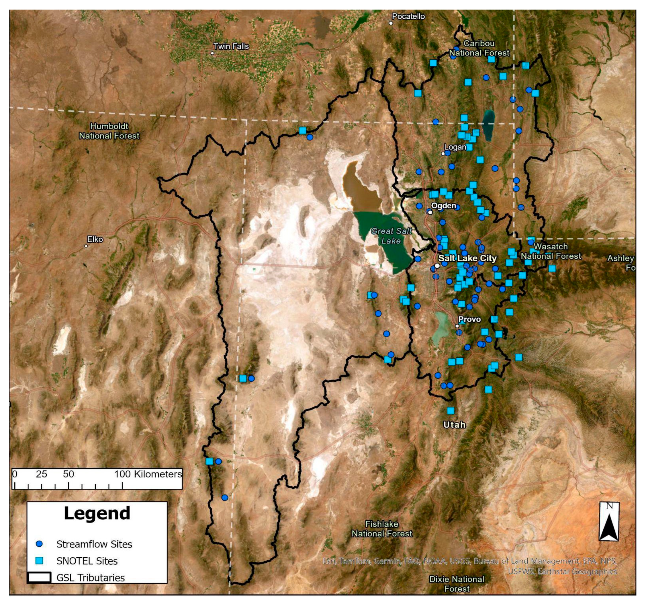
Following this, streamflow data were sourced from the USGS National Water Information System (NWIS) Web Interface [
19]. Streamflow monitoring sites located within the Great Salt Lake Watershed boundaries that had been actively recording data for a minimum of ten years during the study period (2001–2021) were selected. These sites provided monthly average streamflow data measured in acre-feet, a standard volumetric unit used in water resource assessments.
Additionally, snowpack data were gathered from Snow Telemetry (SNOTEL) stations, managed by the Natural Resource Conservation Service (NRCS) [
20]. The SNOTEL network offers start-of-month snowpack values measured in snow water equivalent (SWE). These data capture seasonal snow accumulation and melt patterns, which is the primary contributor to streamflow in the Great Salt Lake Watershed. Accessed through the NRCS’s Air and Water Database Report Generator [
20], this snowpack data provides essential snapshots of snow storage levels that can be correlated with tree canopy and streamflow data to assess the relationship between the two variables. Once these two datasets were collected, the streamflow sites and SNOTEL stations were grouped by their local watersheds (
Figure 4). Organizing the data by sub-watershed ensured consistency in spatial units, allowing for clear comparisons among regions within the Great Salt Lake watershed.
After collecting hydrological data, spatial data were gathered to serve as independent variables within the snowpack model, creating the geographic and environmental context needed for analysis. These spatial variables are land cover, precipitation, elevation, latitude, aspect, slope, and temperature. Each source is cited below as the datasets are further explained. Each of the spatial independent variables were gathered as land mosaic rasters. After this, each raster dataset was compiled into two separate time intervals, 2001–2011 and 2011–2021. The presence of these two-time steps allows for comparison over time, offering insights into landscape changes and their potential effects on hydrological patterns. All spatial data processing was performed using ArcGIS Pro Version 3.3.2, using its spatial analysis and raster calculation tools to standardize and organize the data.
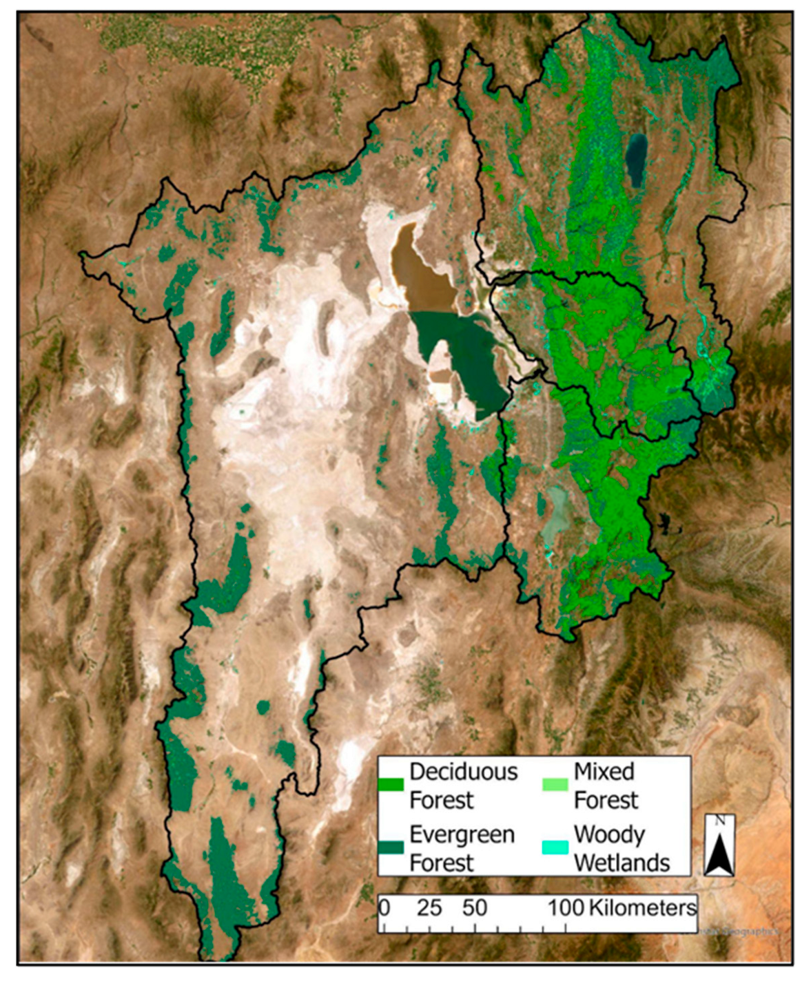
Land use/land cover data were the 2001, 2011, and 2021 versions of the National Land Cover Database (NLCD) from the USGS [
21]. The NLCD provides land use and cover data at a 30 m resolution. For this research, raster cells were filtered using ArcGIS’s Reclassify tool to include deciduous forest, mixed forest, coniferous forest, and woody wetlands. The resulting rasters from the two decades provide a targeted view of tree canopy coverage (
Figure 5).
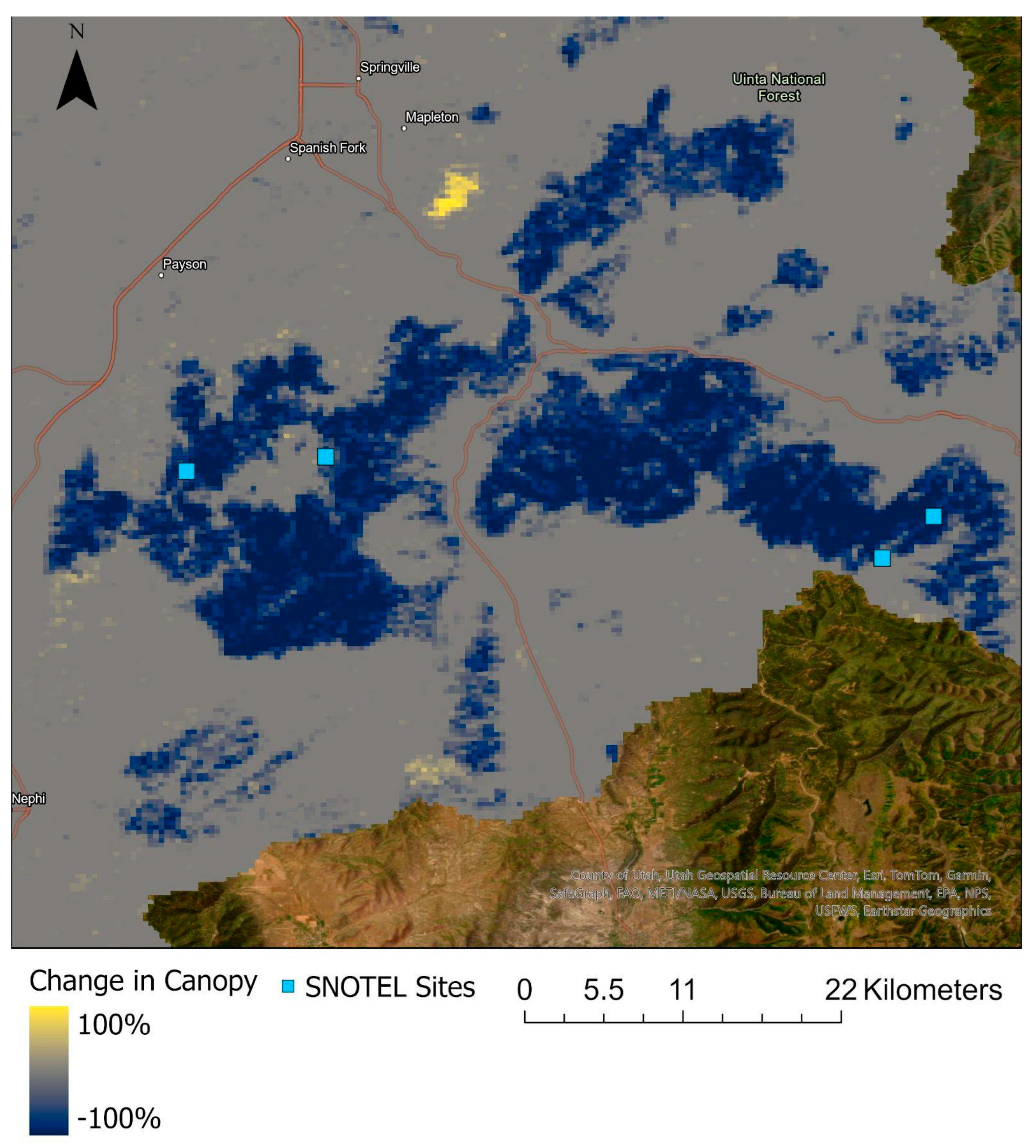
Following extraction, tree canopy data were aggregated into 300 m × 300 m raster cells to calculate the percentage of tree canopy cover within each area, scaling from 0 to 100% to represent canopy density. To evaluate changes in tree canopy coverage over the study period, the tree canopy percentage values from the 2001 dataset were subtracted from those in the 2021 dataset. This calculation produced a differential map with values ranging from −100 to 100, indicating areas where canopy cover had significantly increased, decreased, or remained stable (
Figure 6). This measure of canopy change enables the model to account for vegetation shifts over time, showing how these changes may impact snow accumulation in the watershed.
Next, a high-resolution elevation raster mosaic was acquired from the USGS 3D Elevation Program at a 1/3 arcsecond scale (roughly equivalent to a 10 m spatial resolution) [
22]. This elevation dataset is an indicator for air temperature patterns, which affects snowpack formation and melt. The elevation raster was then used to derive slope and aspect data for the Great Salt Lake watershed.
Steeper slopes prevent snow accumulation and allow for faster runoff. Aspect, or the compass direction the slope faces, affects the amount of incoming solar radiation. South-facing slopes in the Northern Hemisphere receive more sunlight, promoting faster snowmelt. The generation of these slope and aspect layers was conducted using the Slope and Aspect tools in the Spatial Analyst toolkit within ArcGIS.
The next step in modeling snowpack behavior involved gathering relevant climatological variables. Monthly average daily high temperature rasters were downloaded from NASA’s Daymet climatological dataset [
23]. Daymet is derived from a collection of algorithms and computer software designed to interpolate and extrapolate from daily meteorological observations to produce gridded estimates of daily weather parameters. It is an excellent dataset to provide measurements of near-surface meteorological conditions where no data-gathering instruments exist.
Next, temperature values from each month between October and May were averaged to create a composite value termed the winter daily high (WDH). This timeframe was selected to capture the full span of the snowpack season, covering periods of snowfall accumulation and subsequent melt. WDH serves as an indicator to approximate the timing and intensity of snowpack melt through air temperatures during winter months. To assess temporal changes in snowpack behavior, WDH rasters were generated for two distinct periods, 2001–2011 and 2011–2021. Comparing these two timeframes will show how shifts in average winter temperatures may be impacting snowpack dynamics within the watershed.
Precipitation data were also downloaded from NASA’s Daymet dataset, which provides monthly precipitation totals at a 1 km × 1 km spatial resolution. This fine-scale precipitation interpolation allows for the explanation of snowpack variability at individual SNOTEL sites. Similarly to the temperature rasters, these monthly datasets were selected for October–May precipitation, when most of the precipitation falls as snow.
Thus, this study excludes summer rain and its interaction with the tree canopy. While this may bias the analysis towards winter conditions, the vast majority of precipitation falls as snow in the Great Salt Lake watershed, and the exclusion of summer precipitation will affect only about 5% of water supply [
12]. This precipitation data was then averaged for the same two time periods as the other variables (2001–2011 and 2011–2021).
The dataset, now containing variables on tree canopy coverage, elevation, slope, aspect, temperature, snowpack, streamflow, and precipitation, was then ready for statistical analysis. Using ArcGIS’s Multivalue to Point tool, each independent variable was attached to every SNOTEL site and imported into IBM’s statistical analysis program, SPSS version 29.0.2.0. SNOTEL sites were split into two different groups: less than 70% tree canopy coverage (n = 19) and greater than 70% tree canopy coverage (n = 40). Several
t-tests were run on associated variables in order to compare maximum snowpack levels with and without significant tree canopy coverage. Once that was completed, variables were run through a principal component analysis and integrated into a multivariate linear regression (MLR) model. This statistical model was chosen to account for the complex interactions between the several environmental factors affecting snowpack levels. For the MLR analysis, snow water equivalent was averaged for each SNOTEL site to create a mean snowpack depth. Once completed, the independent variables were entered into a stepwise model. Each variable, its explanation, and its hypothesized effect is listed in
Table 1.
The final step in the methodology serves to provide a case study in the influence of tree canopy on snowpack in the Great Salt Lake watershed. The Pole Creek Fire is a major wildfire event in 2018 that significantly altered vegetation cover within the Spanish Fork Watershed [
24,
25]. The fire burned through 400 square kilometers of forest and altered four different SNOTEL sites. Post-fire tree canopy data, sourced from the NLCD 2021 raster, was compared to pre-fire conditions to quantify changes in canopy coverage within the extent of the fire (
Figure 7).
To understand how the tree canopy removal affected snowpack, three SNOTEL sites affected by the Pole Creek Fire, and three nearby unaffected sites were chosen to compare post-fire conditions. These three unaffected points were selected for their close geographical distance to the burned SNOTEL sites (
Table 2). The removal of tree canopy is hypothesized to affect the snowpack in two ways: altering the maximum SWE and changing the phenology of the snowpack. Thus, three variables were used as indicators for these possible effects: Max SWE (quantity), Day of Max SWE (timing), and Last Day of Snowpack (timing). In all cases, a 10-year average was calculated for each SNOTEL site. Then, max SWE and day of max SWE from each year of 2012–2023 was compared to this average. Comparisons were made between individual sites before and after the Pole Creek Fire as well as between sites with canopy removal and sites without canopy removal.
3. Results
The statistical analysis of snowpack in the Great Salt Lake Watershed revealed several patterns and relationships of environmental conditions on snow water equivalent (SWE).
T-tests showed a statistically significant difference in SWE between SNOTEL sites with less than 70% canopy coverage and those with greater than 70% canopy coverage (
p < 0.01) (
Table 3). Also, two explanatory variables showed significant differences between canopy conditions. Elevation showed a significant relationship with SWE levels in a one-sided
t-test (
p < 0.1). Additionally, mean winter precipitation is another significant factor influencing SWE, with a two-sided
t-test confirming this relationship (
p < 0.1).
The resulting multiple linear regression model satisfied all necessary assumptions for its analytical reliability. Specifically, the model confirmed a linear relationship between SWE and the selected independent variables. It also contained no significant collinearity issues, displayed homoscedasticity in residuals, showed no autocorrelation, and achieved a normal distribution of residuals. These conditions validate the model’s appropriateness for this dataset and its predictive accuracy.
The multiple linear regression model shows that tree canopy coverage does not significantly influence SWE (
Table 4). When controlled for the effects of precipitation and elevation, the model excluded canopy coverage in each of its four iterations. This result suggests that canopy coverage is not a significant driver of snowpack variability within the Great Salt Lake watershed. Instead, the model identified four key independent variables as the most influential predictors of SWE. These variables are mean winter precipitation, elevation, average daily winter high temperature, and latitude. The model achieved an R
2 value of 0.763, indicating that 76.3% of the variance in SWE could be explained by the four predictors. Finally, each of these explanatory variables were statistically significant at the
p < 0.01 level.
The analysis of the Pole Creek fire’s impact revealed minimal effects on SWE at the SNOTEL sites located within the burned areas. In the case of all three examined variables, interannual variability was the dominant effect on variation within SNOTEL sites (
Table 5,
Table 6 and
Table 7). Additionally, comparisons between pre- and post-fire yielded no significant values at the
p = 0.1 level. No comparisons between burned and unburned sites yielded
p < 0.1 either.
4. Discussion
The analysis of snowpack in the Great Salt Lake Watershed reveals a clear picture of the key environmental factors affecting snow water equivalent (SWE) and how to move forward sustainably. This has important implications for water policy and the management of natural resources. While initial
t-tests showed a significant difference in SWE between SNOTEL sites with low canopy coverage (<70%) and those with high canopy coverage (>70%), tree canopy coverage itself was ultimately excluded as a predictor in the multiple linear regression (MLR) model. This finding suggests that canopy coverage is not a significant driver of SWE variability across this watershed, and the proposed action of tree thinning would not increase water supply in the Great Salt Lake’s watershed. The lack of significance for canopy in the MLR analysis aligns with the observation that SWE is more heavily influenced by other environmental conditions. This aligns with previous research performed on tree canopy and snowpack dynamics [
5,
6,
16,
18].
Mean winter precipitation, elevation, average daily winter high temperature, and latitude—emerged as the primary predictors of SWE in the watershed. Each was statistically significant at the p < 0.01 level, and together they explained 76.3% of the variation in SWE, as reflected in the model’s R2 value of 0.763. This MLR model falls within expected conditions for snowpack conditions and agrees with the general consensus for snowpack dynamics. Mean winter precipitation directly impacts snowpack levels and elevation, and temperature determines melt rates and accumulation conditions. Latitude also played a role, potentially due to its correlation with temperature gradients across the watershed.
The effect of the Pole Creek Fire as a removal of tree canopy on affected SNOTEL sites was minimal and not significant. Maximum SWE content, Date of Maximum SWE, and Date of Total Snow Melt failed to show a significant difference with each individual site as well as comparison to unaffected SNOTEL sites. This suggests that canopy removal from fire did not lead to substantial changes in SWE and sustaining current canopy coverage is not adversely affecting water supply. These findings are contrary to those found in other studies, where regions that experienced fires were impacted negatively in relation to snowpack [
26,
27].
This variability may point to a more complex relationship between canopy cover and SWE than can be fully captured in this model. This could be due to the observed effect of evapotranspiration on precipitation levels in montane forest environments [
28]. The Pole Creek fire has the potential to provide a particularly important case study for tree thinning, as the abrupt canopy removal mimics the type of manual removal performed in canopy thinning treatments. In a sustainability context, this means that time and resources spent on canopy thinning would be better off looking for other ways to increase streamflow to the Great Salt Lake. Still, with a small sample size (n = 3) for SNOTEL sites affected by the fire, the statistical reliability of this observation is limited. Additionally, interannual precipitation variability, especially events like the record-breaking snowpack in 2023, makes it challenging to isolate the effects of canopy removal from other environmental influences. Further research should focus on gathering environmental data for these individual sites, narrowing down the scope of study and producing more granular data to better understand the snowpack dynamics in this case.
Several limitations should be noted in interpreting these findings. First, while the MLR model met all the necessary assumptions for validity—including linearity, no significant collinearity, homoscedasticity, no autocorrelation, and normality of residuals—the lack of significance for canopy coverage suggests the need for more granular data to fully understand its potential impact on snowpack. Site-specific factors like evapotranspiration, interception, and sublimation may play an important role in SWE accumulation in small scales, which are difficult to capture in a broader watershed-level analysis. Furthermore, the limited sample size of burned-area sites and the high variability of precipitation from year to year limit the conclusions that can be drawn about the effects of wildfire on SWE.
To gain a deeper understanding of the snowpack dynamics within the Great Salt Lake watershed, further research should investigate more refined spatial scales through targeted case studies and controlled experiments. Examining the influence of site-specific variables—such as evapotranspiration rates, canopy interception, snowpack sublimation, thermal radiation, and shading effects—could reveal mechanisms that play an important role in snowpack accumulation and melt at local levels. These site-scale factors may contribute to snowpack retention or loss in ways that impact water availability within subregions of the watershed.
In addition, future studies should aim to clarify the causal effects of tree canopy removal on snowpack dynamics, with a focus on how these relationships may change in the context of environmental disturbances. Investigating the impact of forest fires and the subsequent changes in snowpack following stand removal would provide valuable insights into the broader ecological consequences of canopy loss on water resources. The primary limiting factor of this project’s analysis of the Pole Creek fire is the lack of time. In the future, a return to this site to analyze snowpack behavior post-fire would be much more fruitful. Furthermore, as fire intensity can impact canopy removal impacts, other fires should be investigated based on the fire strength and intensity to identify its impact on SWE. The final research route that should be addressed in the future is to study how tree canopy cover influences the conversion of snowpack to streamflow. Factors such as evapotranspiration, water retention, and soil shading may affect the volume of snowmelt that reaches water bodies like the Great Salt Lake, highlighting another dimension of tree canopy’s potential role in water dynamics.
5. Conclusions
The findings of this study offer valuable insights into the interactions between tree canopy coverage, climate variables, and snowpack dynamics within the Great Salt Lake watershed. Although there was a higher snow water equivalent (SWE) at SNOTEL sites with >70% tree canopy coverage, it was not due to the difference in canopy conditions. Instead, mean winter precipitation and average winter daily high were the dominant controls on snowpack accumulation and retention. This suggests that potential water yield gained from widespread canopy removal would likely be negligible within the watershed. As such, efforts targeting water sustainability in the Great Salt Lake region may be better directed toward areas where climate variability, water storage, and demand directly intersect, likely through agriculture and municipal water use, rather than through large-scale vegetation management.
This study points to the need for more research on snowpack dynamics at smaller spatial scales to understand small-scale processes like evapotranspiration, interception, sublimation, and thermal radiation, which could influence watershed hydrology in ways that broader-scale analysis may miss. Future research should also focus on how disturbances like forest fires impact snowpack dynamics, as canopy loss could alter snow accumulation and melt patterns. Research in this direction plays into another aspect of sustainability through fire management and forest health. Additionally, it will clarify how much snowmelt reaches critical water bodies, which is essential for supporting sustainable watershed management.
In conclusion, the decline of saline lakes like the Great Salt Lake is a complex issue shaped by economic demands, environmental changes, and human activities. As such, an effective response to this issue requires a well-rounded understanding of these intersecting factors to protect and sustain the natural systems upon which we depend. This paper contributes to the body of knowledge through the study of the interaction between land cover and precipitation and its effect on water availability. The insights from this study are especially relevant as climate variability intensifies, raising the need for informed and adaptable approaches to sustainable water conservation and ecosystem management. Such policies can tackle present environmental issues while also building resilience for the future, helping protect the watersheds we rely on.


