Article

Supply and Demand Analysis for Designing Sustainable National Earth Observation-Based Services for Coastal Area Monitoring

1
The Italian Institute for Environmental Protection and Research (ISPRA), Via Vitaliano Brancati 48 and 60, 00144 Rome, Italy
2
Science Technology Society, Scuola Universitaria Superiore (IUSS) Pavia, Palazzo del Broletto, Piazza della Vittoria, 15, 27100 Pavia, Italy
*
Authors to whom correspondence should be addressed.
Sustainability 2025, 17(12), 5617; https://doi.org/10.3390/su17125617
Submission received: 7 April 2025 / Revised: 27 May 2025 / Accepted: 12 June 2025 / Published: 18 June 2025

Abstract

:
Here we take the example of Italy to demonstrate a country-level approach to the design of a sustainable system of Earth Observation (EO)-based products to match the demand/supply for monitoring coastal zones and to guide the development of new products based on national/local users’ needs complementary to Copernicus Core Services products and its future development. With support from the Coastal Thematic Consultation Board of the Italian Copernicus User Forum, we applied a standardized methodology involving elicitation, selection, analysis, validation, and requirement management. Our findings reveal a strong national need in EO-based products for coastal monitoring and services provision. The survey results offer insights into how existing products and services meet user needs on the national scale, for monitoring several parameters pertaining to four classes, biological, geomorphological, physical, and chemical, highlighting additional demands and integration opportunities with the evolving European Copernicus Coastal Hub. The innovation of this work lies in the design of a foundation for a holistic approach to complement European and national EO systems, both in terms of data to be acquired with synergistic satellite missions and in situ infrastructures and in terms of the development of sustainable products, models, and algorithms for downstream value-added services.

1. Introduction

Coasts are unique environments in which the atmosphere, hydrosphere, and lithosphere are in contact with each other. They are highly dynamic due to many natural physical processes, such as longshore and transversal beach dynamics, tidal inundation, sea level rise, and land subsidence. Coastal areas are also home to a wealth of terrestrial and marine flora and fauna. At the same time, coastal zones are centers of human activity, with large social and economic values. The Mediterranean basin is characterized by a narrow coastal area with a high density of people and large economic assets, critical infrastructures like seaports and power plants, and human activities such as tourism, fisheries, and navigation [1,2,3]. The established sectors of the EU Blue Economy directly employed close to 3.59 million people and generated around EUR 623.6 billion in turnover and EUR 171.1 billion in gross value added (this data was released by Eurostat and is referring to 2021 [4]). They could outperform the growth of the global economy, both in terms of added value and employment, according to the “Organization for Economic Co-operation and Development” (OECD) by 2030. However, this potential is inextricably linked to the application of management practices able to maintain the integrity of marine ecosystems and the services they provide [5].
With reference to human activities, it is also important to take into account ecosystem services, which are essential for human well-being [6,7,8,9,10], such as coastal hazard protection [11,12,13], food and livelihood security [14,15], carbon sequestration [16,17], and recreation opportunities [18,19]. In recent years, the coastal zones, probably more than any other part of society, have been exposed to pressures and processes of change [20,21,22,23]. Rapid socio-economic expansion has led to significant impacts on the environment, threatening coastal communities. Increasing urbanization and intensive production have contributed to land subsidence and saltwater intrusion in surface water and groundwater. Sewage, agriculture, and other industrial activities have increasingly polluted coastal water, while other human activities, like natural resource extraction, fishing, and energy generation, are causing ecosystem disturbances and habitat loss [24]. Climate change is expected to combine with the above burdens, accelerating biodiversity loss and ecosystem depletion and exacerbating impacts on coastal communities, and hence, undermining ecosystem services related to fisheries and aquaculture, tourism, and long-term sustainability [25,26,27,28].
As growing changes are expected to pose increasing challenges to coastal zones, climate adaptation, coastal resilience, and sustainable environmental management should be key objectives in the planning and implementation of coastal zone policies [29]. To address these pressures and plan future coastal management and adaptation policies, such as those included in the Integrated Coastal Zone Management [30] Protocol of the Barcelona Convention, monitoring and recording as a network what is taking place at the coasts is required for all the Mediterranean countries [1,30]. To this end, Earth Observation (EO) from space, including EO integrated products such as numerical models, has proven to be a powerful and cost-effective approach [20,31,32], for example for flood monitoring [33,34,35], land-use cover and change [31,36,37], sea-state forecasting and sea level change [38,39,40], urban development, and coastal wetland loss [41,42,43]. Backed by this research, the Conclusions of the Council of Europe on “Space for People in European Coastal Areas”, prepared in view of the Competitiveness Council held on 28 May 2021, recall the importance of the Space Program for the monitoring and previsions of the coastal environment, contributing to a sustainable development of human activities in a balanced approach towards the long-term preservation of ecosystems and related marine and land biodiversity.
In the framework of EO-related products, the contribution of the Copernicus EO Program of the European Union (Regulation (EU) No 377/2014—former GMES and most recent Regulation (EU) No 696/2021) is of the utmost importance. In particular, with regard to the monitoring of coastal zones it is important to consider products offered by the joint efforts of the Copernicus Land Monitoring Service (CLMS), the Copernicus Marine Environment Monitoring Service (CMEMS), and the Copernicus Climate Change Service (C3S) to build the new Coastal thematic Hub (https://www.coastal.hub.copernicus.eu/, accessed on 7 June 2023, launched during the 7th Copernicus Marine General Assembly on June 2023) to better characterize coastal zones through EO offerings, with strong relevance to various aspects of coastal sustainability and management. The complementary baseline information and products from these services constitute a harmonized and comprehensive monitoring strategy and support the implementation and assessment of EU policy effectiveness. In fact, the combination of data from satellite Earth observation, in-situ sources, and numerical models can provide information on a regular basis over long time periods. Additionally, the predictive power of these systems can provide short and long-term future forecasts to foresee the impacts of climate change on coastal zones, including the evaluation of the effects of storms and floods at the coast. Even more progress in coastal monitoring and products is planned under the Program extension to 2027 (Copernicus 2). Furthermore, for instance, in 2019, the European Commission initiated a coordinated action to evaluate the current and potential uptake of Copernicus products for the monitoring and protection of European Cultural and Natural Heritage in a future climate change scenario [44]. The results of the task force show what users require from Copernicus to face the daily challenges of preserving and protecting coastal heritage features, and some of the expressed requirements fall in the marine and coastal domains. The requirements identified in this frame by European users have been validated with the Copernicus Entrusted Entities (in this case, CMEMS), and a significant number of identified requirements were already satisfied by the existing operational products [44].
In 2020, the Med7 countries (Cyprus, France, Greece, Italy, Malta, Portugal, and Spain), in the framework of the Med7 agenda, produced the white paper “Copernicus for the blue economy in the Mediterranean Sea and beyond” (Ref. DG DEFIS internal protocol: Ares (2020)3734020—15 July 2020). This document supports and orientates the Road Map designed in 2019 by Mercator Ocean International and the European Environment Agency for the EU Commission concerning the evolution of coastal services in the framework of the Copernicus Program, providing a specific focus on the needs of Mediterranean countries. In fact, the intense concentration of human activities in many coastal areas of the Mediterranean, both on land and in the marine environment, creates additional environmental and socio-economic needs, requiring additional products, based on integrated in situ, satellite, and modelling data, often at high resolution and local scale. The document supports the importance of:
  • Sharing coastal data and information for use and re-use to give added value to existing products. This goal could be achieved if data and information were easy to access: a national access point to coastal data and information would provide a complete picture of the available data.
  • Harmonizing local coastal products across MSs and neighboring countries with the goal of getting a homogeneous picture of the whole basin. Moreover, the availability of homogeneous products favors the development of the market and attracts large-scale investments.
  • Identifying user needs starting from the institutional market to help EU Member States with the use of EO products for institutional tasks, thereby also helping the development of commercial downstream products.
  • Fostering a larger and recognized use of EO for environmental reporting, for instance, through a regulatory action that promotes the uptake by public institutions and private companies of EO data.
  • Promoting the planning of private future investments by clearly distinguishing between free product segments and those left to commercial services.
Copernicus core services are designed to provide a homogeneous picture at the European level with standardized products and services. On the contrary, the heterogeneity of coastal areas in Europe, with different physical features, mainly due to different natural phenomena and human activities, must be tackled at the local scale, which falls under the responsibility of Member States. Developing products specific to coastal issues at the national level is expected to bring great benefits in the context of the Green Deal and digital priorities; thus, a consistent set of actions is envisaged both at the EU and national levels. National services aimed at contributing to the coastal monitoring should be based on users’ needs and, where possible, be built in complement with already existing public and private monitoring systems. Thus, it is important to map the national users’ needs and the existing products, and to identify information lacks for marine and land applications in coastal areas to be used (i) as a baseline to promote recommendations for future development; (ii) to harmonize the demand at national level easing the market development, and (iii) for the potential integration of national products to the existing ones and the new Copernicus Coastal Thematic Hub.
Here we take the example of Italy to demonstrate a country-level approach to the analysis of the system of EO products’ demand/supply for monitoring changes in coastal zone environment [45] and to guide the development of sustainable new products based on sub-national/local users’ needs [46], as depicted in Figure 1. The term “sustainability” associated with “products” and “services” highlights the importance of careful planning to guarantee their usefulness for coastal users, to allow funding both by institutional and commercial bodies, and their synergies and complementarities with existing national and European products.
The collection and analysis of the users’ needs for the development of coastal services is the starting point for defining the building blocks of the different services at both European and national levels. This approach allows for the construction of service architecture based on the complementary integration of elements, defining the different types of input data, processing and modeling, and output products and how they can be composed to achieve the specific requirements. This action must necessarily be carried out with consideration of the synergy among the various national and European programs and the resources they make available.
Schiavon et al. [47] highlighted how the potential cross-missions and data coordination, together with the identification of the main gaps between user needs and satellite capabilities, influence the development of key national and trans-national downstream services for specific thematic domains and represent an opportunity to address shared community needs around product and algorithm development. In the case of coastal zones, previous studies mainly focused on the identification of thematic users’ needs for coastal services [48]. In particular, El Serafy et al. [49] clearly highlight the need to link users’ needs to a complete survey of existing products, providing a general list of different types of products existing at the European Level. In Italy, there is a wide and complex panorama of institutional and private users, national services, and applications already in operation for the monitoring and management of the coastal zone. Geraldini et al. [50] analyzed this system, focusing on institutional stakeholders to identify requirements for the monitoring of coastal areas and gaps in the current (2020) Copernicus and EMODnet product offers. The Authors concluded that the Copernicus services are not well fine-tuned to characterize the state of coastal areas at the local scale, which requires the improvement of spatial resolution and the assimilation of local conditions and in situ data. We depart from this observation, and we take a further step by including additional stakeholders (also from other public entities and private sectors) and surveying for the first time existing EO products and services operating at the national level to understand if these can fill the demand gaps in the coastal sector evidenced from the Copernicus and EMODnet offer. Specifically, our analysis aims to (i) evaluate the national demand for products and services in coastal areas to identify gaps between users’ needs and existing products (ii) identify key thematic areas where the national offer expertise is strong; (iii) foster the complementarity and the usefulness of existing and developing coastal services.
The analysis of demand/supply performed in this study has been supported by the Italian Copernicus User Forum (www.copernicus-italia.it), established in 2014 in the framework of the Italian Presidency of the Council of Ministers, to actively solicit that national stakeholders formulate their needs in terms of data, information, and services related to EO. Within the User Forum, a thematic discussion group, “Tavolo Fascia Costiera” (TFC—literally “Coastal Zone Board”), has been constituted to discuss and analyze the point of view of national actors in coastal areas [50]. Benefitting from this consultation board, we applied a standardized methodology consisting of a step-by-step process of elicitation, selection, analysis, validation, and management of the requirements [50,51]. First, we identified the background and the users’ categories. Then, we produced different written surveys to collect information on the supply and demand of coastal products. The surveys’ results were analyzed separately to determine unambiguous requirement specifications and an up-to-date view of available national coastal products in Italy. Finally, they were matched to identify gaps in the supply/demand system and to define the future EO services and data implementation strategy to fill the gap.

2. Materials and Methods

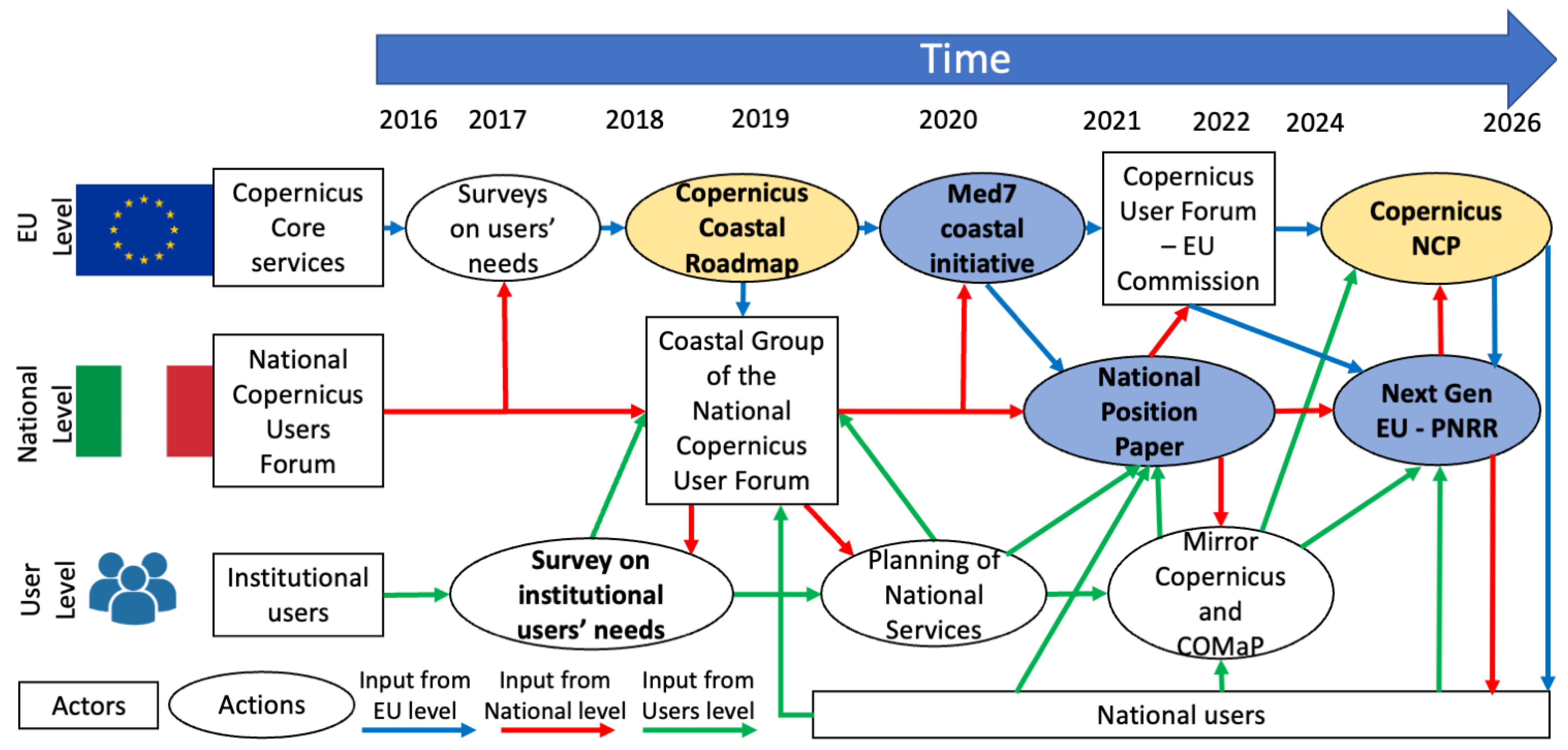
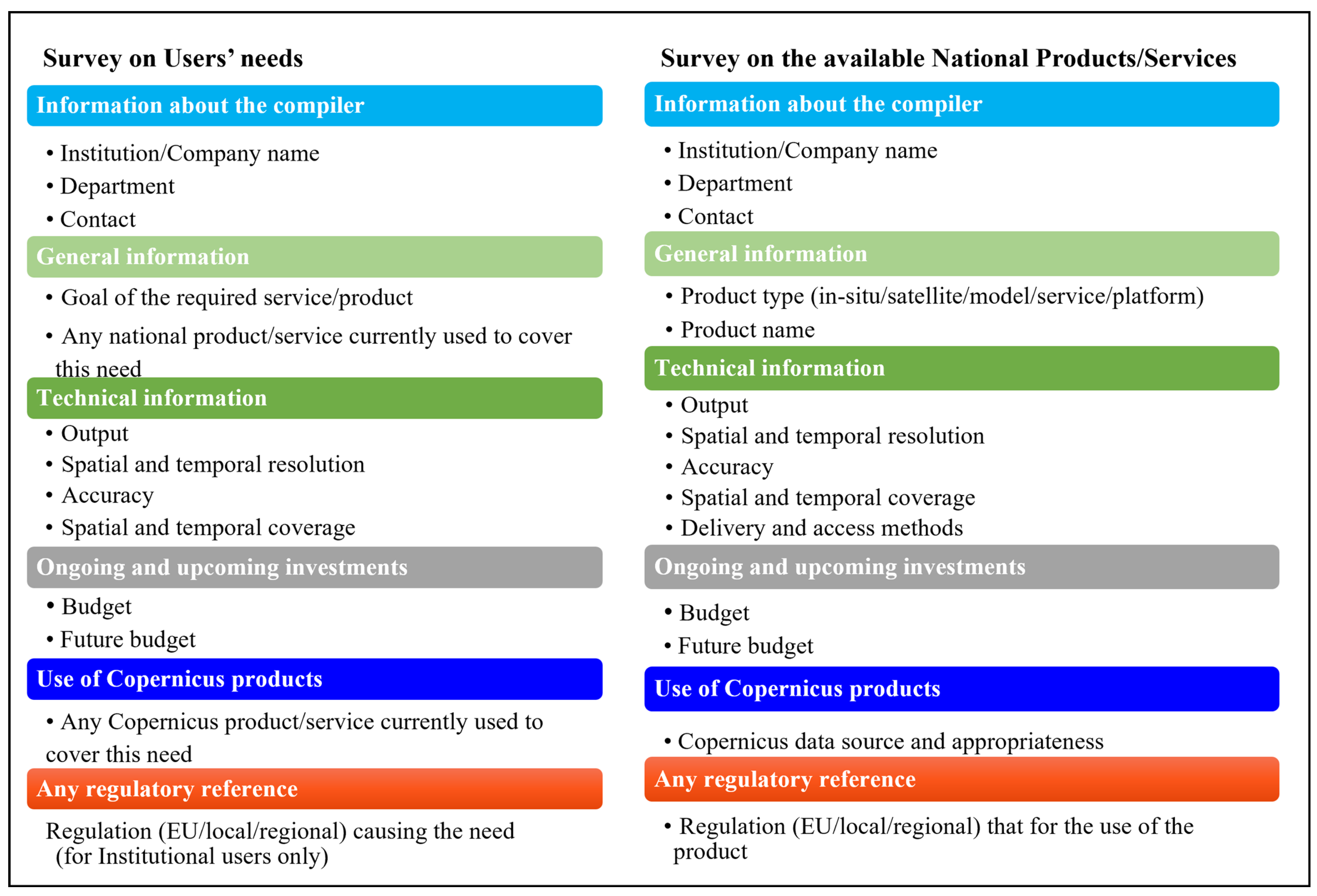
2.1. The Consultation Boards and Questionnaires

To collect data on existing products and to analyze the users’ needs, we capitalized on the results of the consultation process carried out by Geraldini et al. [50]. In this study, requirements have been obtained by sending questionnaires to a large range of institutional users needing specific operational services in coastal zones to accomplish their institutional tasks, in line with existing regulations and infrastructures. The advantage of using questionnaires is that they adapt to different types of audiences, collect data in a standardized manner, and are very cost-efficient [52]. Thus, in the present study we broaden the consultation process using the same approach, and we include the institutions and entities participating to the TFC and the participants of the “coastal implementation group” organized by “Tavolo Valorizzazione” (literally “Valorization Board”), that, in the framework of the Italian Copernicus User Forum, enables the discussion among institutional, industrial and research players to maximize the development efficiency of operational services and their impact on the market by involving the various players in different sectors. This latter consultation board included all the TFC participants and many private companies to foster the development of a marketplace of coastal services by matching demand and offer (Table 1).
Being composed of a wide range of stakeholders in both the public and private sectors, our analysis includes a varied sample to highlight the key features of the Italian users’ needs and requirements to monitor global changes in the coastal zone and the available products and services developed at the national level for this scope. The questionnaires presented to the above consultation boards to collect information on the requirements and available national products were structured in a matrix format and were composed of the following parts: (1) information about the compiler; (2) general information about the product (name, type, and whether it was in-situ, satellite, or model); (3) technical information about the product including spatial and temporal resolution and cover, accuracy, delivery, and access methods; (4) ongoing and upcoming investments in the product; (5) information whether Copernicus products were used in the product or to meet the need; (6) any regulatory reference for the product use (Figure 2).

2.2. Analyses of the Questionnaires

We analyzed the survey outcomes considering four classes of parameters requested or monitored by the product/service: (1) physical, including those related to energy in water or forces (e.g., currents, waves, temperature, underground noise, etc.); (2) chemical, including all the parameters related to chemical elements or substances in the water (e.g., salinity, nutrients, litter, etc.); (3) biological, including all the data about living beings in the water and chlorophyll; (4) geomorphological, including all the data related to sediments and geological and morphological features, with measures on the extension of coastal habitats (e.g., TSS, sediment size, bathymetry). Products and services were also analyzed according to additional criteria: acquisition, processing, temporal, and geographic.
We classified surveyed products and services according to their acquisition method considering in-situ data, remote sensing-based products and services (which include data from satellites and data acquired using remote terrestrial instruments, e.g., radar, video-surveillance cameras, and airborne instruments, including drones), and model-based products and services, even if remote sensing-based products and services may also take advantage of in-situ data, and modelling tools may also take advantage of remote sensing and in-situ data.
From the national perspective of product and service processing, we consider both the available national “data services” and “end-user services”. “Data services” aim at providing basic data and information for monitoring and managing the coastal environment (e.g., environmental impact of anthropic activities and risks induced by environmental conditions on human interests). Such data and information are used both for near real-time monitoring systems and the provision of long-term time series for evaluating trends or cyclic variations. They are produced through ad-hoc in-situ monitoring campaigns, fixed platforms, terrestrial remote systems (e.g., coastal radars, LiDAR, multibeam, orthophotos, etc.), satellites, and mathematical models. The provided data are expected to be checked for quality, standardized, and made available on open platforms using common protocols. “End-user services” are composed of added value coastal services for specific anthropic sectoral applications (e.g., fishing and aquaculture, energy production, tourism, navigation) and for environmental monitoring, obtained through the elaboration of the data services. These services should also target non-academic or non-expert users, using all available technologies, from simple web services to apps for mobile devices, without requiring users to know and follow all steps in the procedure that led to the service. On the other hand, such a procedure should be fully transparent and open to inquiry from the users.
From a temporal perspective, we consider in-situ data and remote sensing-based products and services as “routinary data” if derived from measures carried over with time (even if there are gaps in the time series), and “data available for a temporal window” if measured within a clear timeframe. If the measuring cycle of data or the provision of a service classified as routinary is interrupted (e.g., lack of funds, instrument malfunctions), it was classified as available in a specific temporal window before the measuring cycle stopped. Then, at its restart, it was moved again to the routine class. For the modelling tools, the temporal classification is based according to their operational task: forecast (meaning short-term forecast) or other operational modes (including hindcast, re-analysis, climate projections, etc.).
Finally, data are classified according to the geographical criterion as “national” if gathered along the entire Italian coasts or sub-national if pertaining to smaller areas, i.e., the Ligurian Sea, Tyrrhenian Sea, Sicily Channel, Ionian Sea, and the Adriatic Sea. In addition, we analyzed data from data archives, classifying them according to the products they contain, i.e., single product, multiple products, interoperable (multiple products and elaboration capabilities), and according to the capability of only viewing or also downloading data and information.
To optimize the development of new products and services towards specific users’ requirements for the monitoring of the coastal zone, the associations that exist between supply and demand were identified. The results are linked to the integration with the current offer of Copernicus EO products in the coastal zone.

3. Results

The elicitation process involved 19 institutional subjects, 9 research institutes and 7 private companies participating in the “coastal implementation group” organized by “Tavolo Valorizzazione” (Table 1).

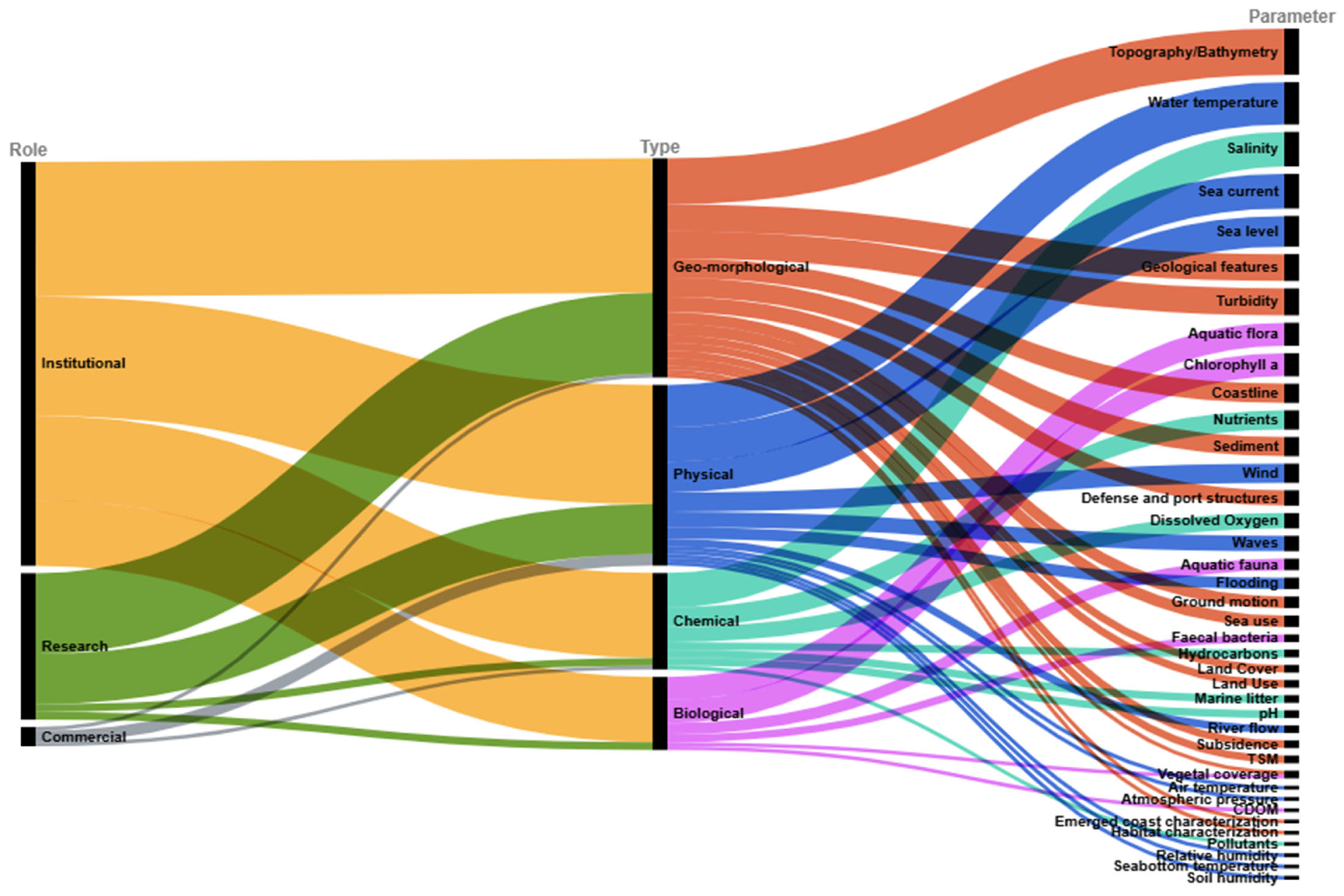
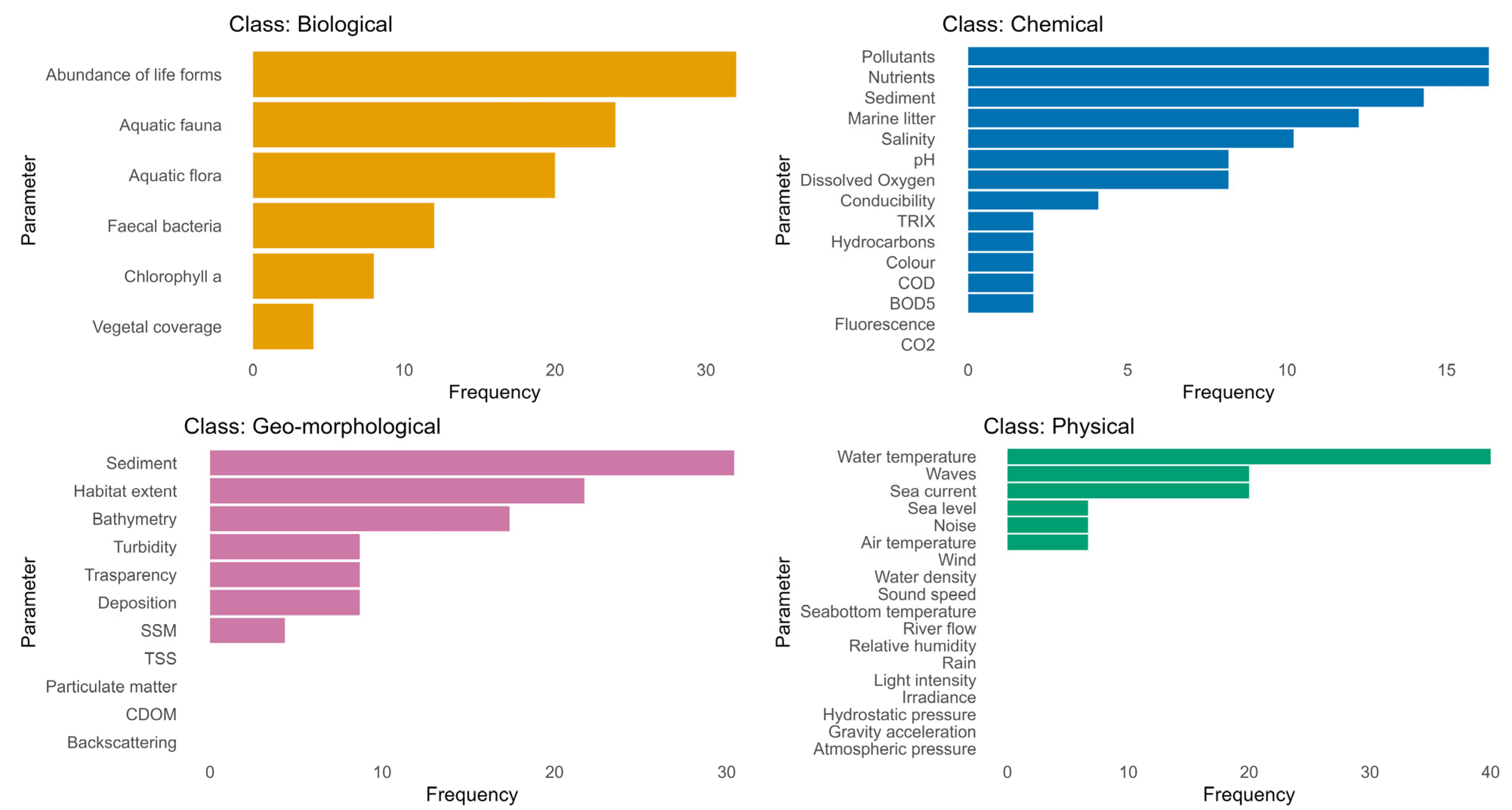
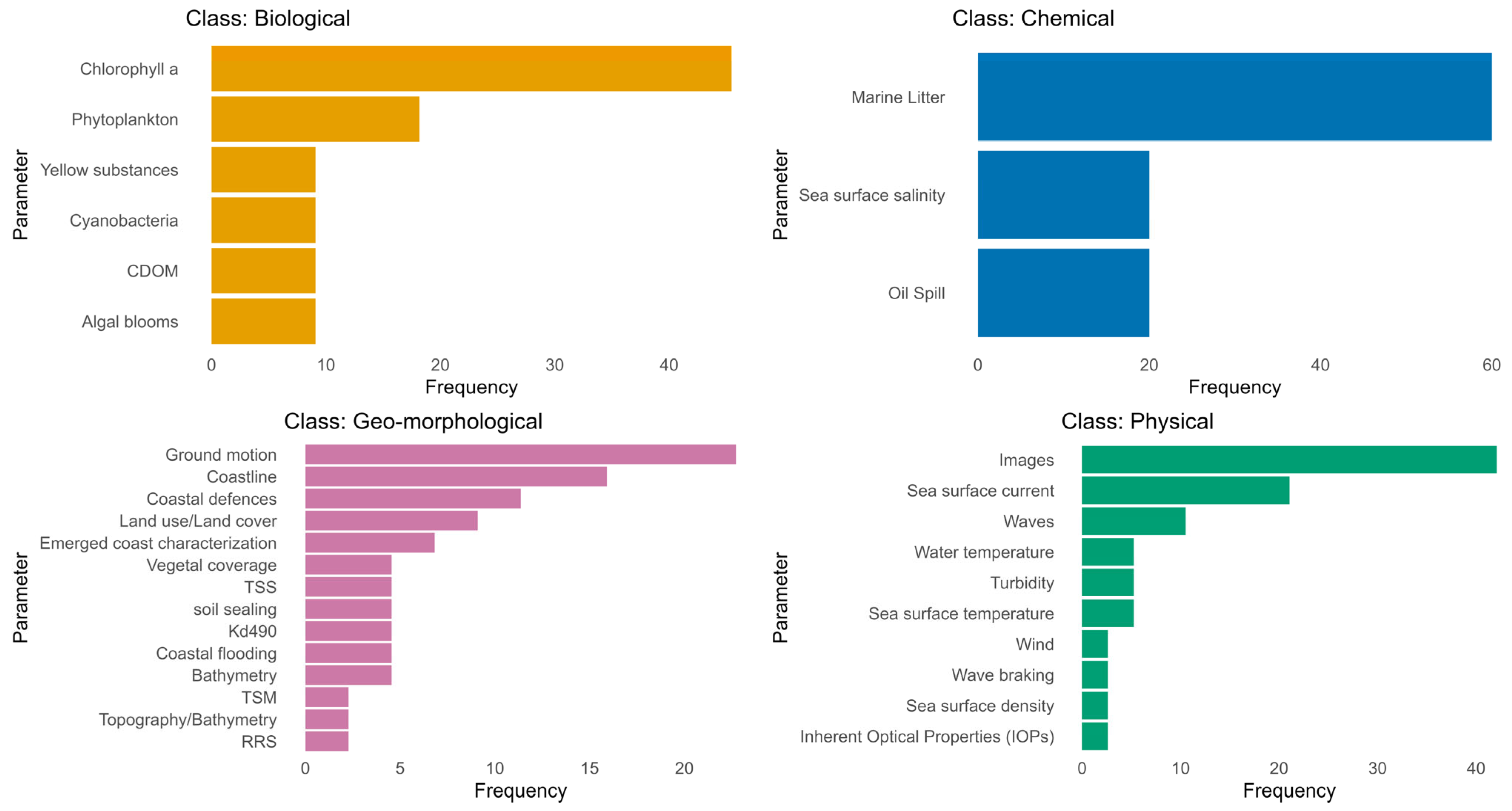
3.1. The Users’ Needs for Monitoring Coastal Zone Changes

We collected a total of 148 requirements, grouped in 39 parameters, to monitor changes in the coastal zone. The most requested parameters are those pertaining to the geomorphological class (38%—with bathymetry and topography being the most requested ones). The physical parameters ranked second in terms of requests (32%), especially all the oceanographic parameters (water temperature, salinity, currents, and sea level). Chemical parameters appear more requested than biological ones (17% and 13%, respectively), but if we remove the salinity parameter, the two classes are roughly equivalent (Figure 3).
Institutional users expressed most requirements (71%), followed by users from the research field (26%) and commercial users (3%). These proportions are similar if we consider the requirements divided into the four parameter classes, except for the geo-morphological one, for which differences among research, institutional and commercial requirements were lower (39%, 36%, and 25%, respectively) (Figure 3).

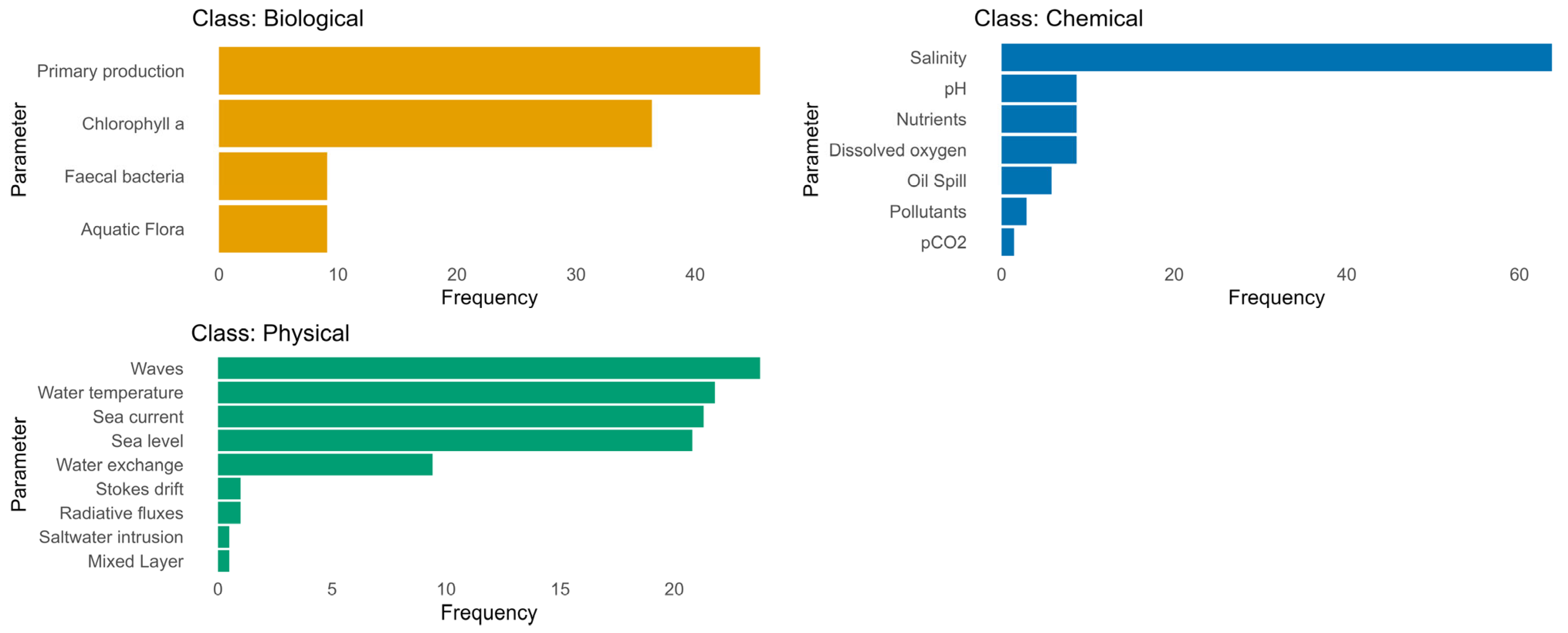
3.2. The Available Coastal Services in Italy on Both National and Sub-National Scales

It is important to note that the methodology for enumerating in-situ services involves considering each monitoring station individually (both for fixed instruments and routine monitoring campaigns). Following such an approach, the number of stations related to national monitoring campaigns carried out in the framework of the enforcement of national laws (mainly deriving from EU directives) is larger than the number of stations for local initiatives by several orders of magnitude. This would result in the flattening of the plots showing the differences among the different areas, should they be analyzed together with local data. Hence, we analyzed them separately. Concerning remote sensing and numerical models-based services, we enumerated them by counting the number of different services for both national and local scales. When summing up all services together, we enumerated national in-situ services as monitoring campaigns (not as single stations), while local in-situ services maintain the already mentioned counting method. This is coherent with the fact that local in-situ campaigns are generally aimed at single spots. Overall, according to our survey, 1010 products and services are available on national and sub-national scales. Considering the outputs they provide, these can be grouped into 86 different parameters, mainly physical (54%) and chemical (28%). Biological and geo-morphological parameters represent only minority fractions (7 and 10%, respectively), and 1% of the parameters are not classified (e.g., vessel traffic).

3.2.1. In-Situ Data

More than half of the products and services (62%) are based on in-situ data. Our survey evidenced a few national programs designed to monitor the general state of the coastal environment in the long term, according to environmental and health protection laws (national and European) or international agreements (Barcelona Convention 2019 UNEP Convention for the Protection of the Marine Environment and the Coastal Region of the Mediterranean and its Protocols, Nairobi). They show a good degree of integration, reusing measures collected in the legislation framework (e.g., WFD converted into Italian law with D.Lgs 152/2006, MSFD converted into Italian law with D. Lgs 190/2010), and they are accessible to some extent (e.g., SINTAI, https://www.sintai.isprambiente.it/, SINA, https://www.isprambiente.gov.it/it/attivita/reti-e-sistemi-informativi-ambientali/sistema-informativo-nazionale-ambientale-sina, EIONET https://cdr.eionet.europa.eu/help/WISE_SoE, all accessed on 13 July 2024). Due to the temporal frequency of monitoring, these programs cannot describe short-term, potentially harmful events, from which the environment could recover, but they are of extreme interest for coastal activities. Many local actions are also carried out non-homogenously according to sub-national institutional initiatives, research activities, institutional research, or commercial focuses on hot spot areas, with very diverse collection strategies. In general, local initiatives are more subject to funding availability problems, resulting in discontinued monitoring activities and difficulties in accessing data.
Networks of in-situ data collection have been planned or developed thanks to long- or short-term coordination actions at the local or national level. For example, the “Gruppo Nazionale di Oceanografia Operativa” (GNOO), a structure of the National Institute of Geophysics and Volcanology (INGV), provided a network for discussing and coordinating the development of national marine monitoring and forecasting activities for about ten years (from 2004), mainly in the framework of research projects. The “Gruppo Nazionale di Ricerca sull’ambiente Costiero” (GNRAC), since 2005, has provided a forum to discuss and compare experiences at the local level and promote best practices in the study of coastal geomorphological features and coastal management.
Among in-situ data, chemical parameters are the most frequently collected in national monitoring programs, with special attention to nutrients and pollutants (mainly based on environmental control). Biological and geomorphological data show almost the same frequency of collection. Among the physical parameters, water temperature is the most measured, both at the national and local levels. The salinity (chemical), chlorophyll (biological), and turbidity (geomorphological) parameters are mostly measured at the local level. At the national level, the abundance of life forms (biological), salinity (chemical), and sediment quality (geomorphological) parameters are the most measured (Figure 4).
According to data gathered in the framework of local initiatives, in-situ data availability is not geographically uniform. The most routine in-situ data are available for the Adriatic Sea (76%), while the most temporal window in-situ data are available for the Ligurian Sea (82%). Only some of the in-situ data collected are accessible with a non-automatic procedure, and the delivered products are generally constituted by a raw dataset rather than an interoperable platform.

3.2.2. Remote Sensing-Based Data and Services

The products pertaining to the category “remote sensing-based data and services” are mainly delivered in the research (37%) or commercial activities (45%) frameworks and refer to physical (40%) and geomorphological (45%) parameters. Out of the four different parameter classes, the most frequent parameters are images and sea surface current (physical), marine litter (chemical), Chlorophyll-a (biological), and ground motion (geomorphological) (Figure 5).
Most products are released at the national level (69%); considering the local level, most products cover the Tyrrhenian Sea (52%). Almost an equal number of services and products are operated in routine or temporal window modes (49% and 51%, respectively). These percentages change when considering the operational mode in relation to the target activities: in the framework of institutional activities, the temporal window mode is prevalent (83%) over the routine window (17%), likely because they still heavily rely on in-situ data for monitoring activities. The routine window is instead prevalent (55%) over the temporal window (45%) for the non-institutional activities. According to the surveys, remote data can be accessed easier than in-situ data, in a processed format e.g., information layers, rather than raw data.

3.2.3. Model-Based Products and Services

Model-based products and services are related to activities conducted mostly by research (79%) and to a lesser extent by institutional bodies (18%) and commercially (3%). Most models focus on physical (71%) and chemical parameters (including salinity) (24%), with the aim of simulating sea waves or coastal circulation (related to sea level, current velocity, water temperature, and salinity) (Figure 6). In the framework of institutional activities, there are also a few tools related to the modelling of sediment-transport-end-seabed evolution. Even if the request for the bio-geo-chemical model is high at the national level, only bathymetry has been developed according to our survey.
Considering the geographical coverage of the model-based products and services, the non-institutional tools cover mainly the Adriatic Sea, while the institutional tools the Tyrrhenian Sea; only a few products cover the whole national level. Numerical models are mainly aimed at forecasting activities for institutional uses (90%), while non-forecasting activities are predominant if one focuses on non-institutional tools (65%) or the whole dataset (56%).

3.2.4. Data Archives

Even if the survey regarding data archives involved the same recipients as the other products, the information gathered is less detailed and abundant. This may highlight a minor effort devoted to disseminating the results rather than producing the service itself. As a result, accessing the available data and information is generally not easy. In addition, data platforms have minimal operational features and are not interoperable or linked to one another.
Data platforms are mainly hosted by institutional bodies (48%), followed by research archives (35%), while commercial initiatives are only marginal (16%). Only 45% of the platforms consider the whole country. Among the local data archives, 59% are devoted to the Adriatic Sea followed by the Tyrrhenian Sea (24%); no data archives are available for the Ionian and Sardinian Seas. Most of the data archives (86%) allow access to data but are not interoperable. Roughly half of them only allow the display of the data, the other half also permits download. It is important to highlight that almost all the surveyed commercial platforms are interoperable and allow both view and download.

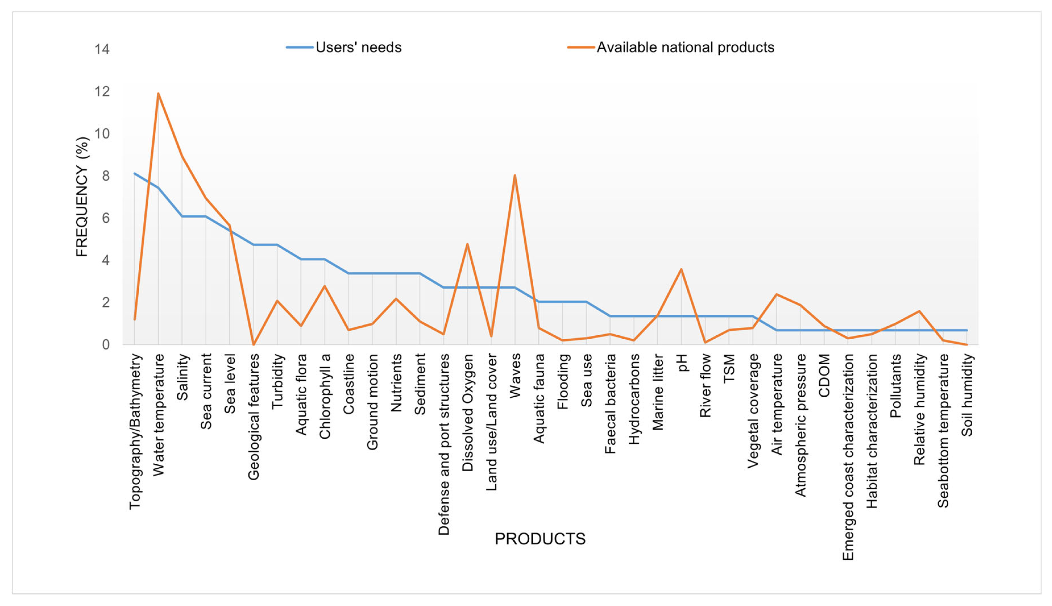
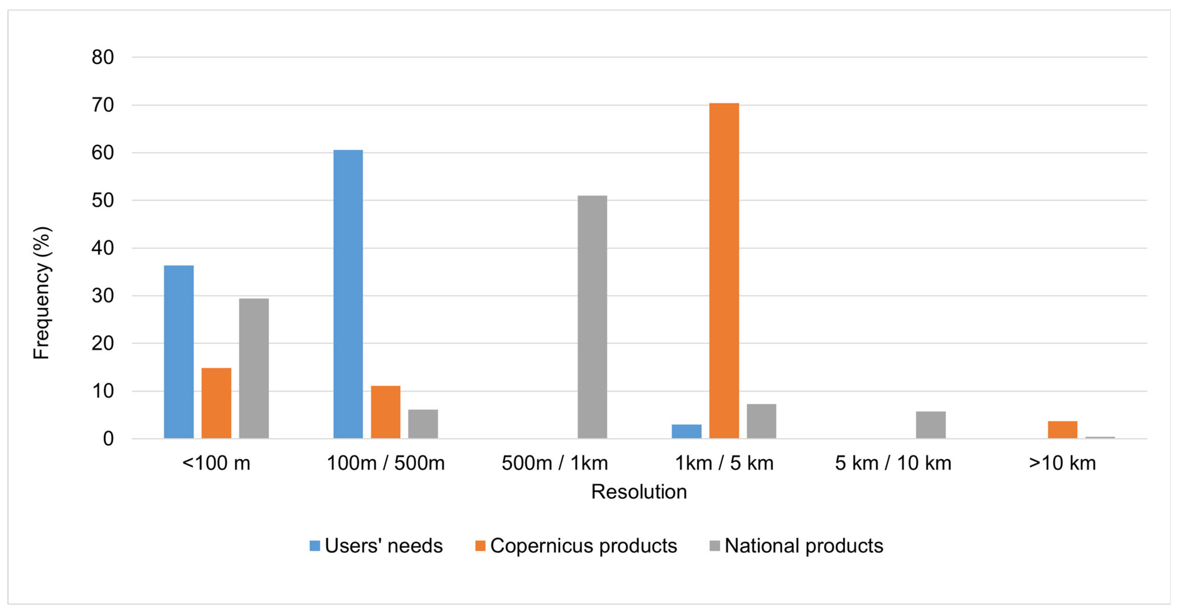
3.3. Analysis of Coastal User Needs and Gaps

To tackle the relationship between demand and offer, we plotted the frequency of products and services related to specific parameters ordered from left to right according to decreasing frequency among requirements (disregarding the specific features of the request and the offer, e.g., temporal and spatial resolution) (Figure 7). Overall, more products are available for the more requested parameters but not for the most requested one, especially for topography/bathymetry and geological features. To analyze the gap in more detail, we considered the spatial resolution as a proxy for the adequacy of services and products to the requirements of coastal users, as previously done by Geraldini et al. (2021) [50] for Copernicus products. In particular, Geraldini et al. [50] offered a comparison between features of services designed to fulfil the requests of national coastal users and corresponding Copernicus and EMODnet products. We started with such data (reference to the list in Table 4 in that paper), integrated with features of six additional parameters emerging from the surveys carried out by the consultation boards (saltwater intrusion, geological features, soil moisture, soil temperature, rivers’ sediment transport and turbidity) and classified them into six spatial resolution classes. We then analyzed the frequency of spatial resolution of products from Copernicus (together with EMODnet) and national services producing data and information for such parameters. Comparing such data, we found that the spatial resolution of available national coastal services is higher than Copernicus services and EMODnet offer [50] and more in line with users’ requirements (Figure 8).

4. Discussion

During the last three decades, the ocean and coastal services have undergone considerable evolution and improvement. Nevertheless, further implementations are required, mainly approaching the coast. The need for coastal product and services improvement has been recently highlighted in a worldwide survey that analyzed the satisfaction of both users and experts working (both public and private sectors) with respect to the existing ocean forecasting systems focusing on the Essential Ocean Variables [53]. The authors evidenced a progressive degradation of the system’s performance as it comes closer to the coast. The significance of this degradation was further emphasized by the analysis of the application survey results, which showed that the demand for these variables is particularly high near the coast. To better answer users’ needs and meet the new ocean monitoring and forecasting challenges relevant for sustainable development required by European policies, the Copernicus Marine Service plans to incrementally evolve products and services by 2028. In this context, a key priority is enhancing the service to better meet the needs of coastal users.
The launch in June 2023 of the novel Copernicus Coastal Hub has been a first step. This platform has been created to gather in a single platform all thematic information generated by the different Copernicus Services on coastal zones [2]. Moreover, because the Copernicus core services are not designed to cover local and very high-resolution scales, which are often required for the coastal environment, the CMEMS coastal extension also regards the co-design and co-production of information with national institutions via deeper interactions with Member State representatives and national entities in the marine domain [2,49]. To this end CMEMS mid-term activity plan foresees the coupling of national coastal systems with Copernicus Marine monitoring and forecasting systems. User engagement programs already support pilot projects that demonstrate coastal use case applications and cross-country collaborations. These initiatives could serve as a key extension of the Copernicus Core Services, complementing and integrating the EU’s provisions (e.g., [54]) to reach the desired resolution and insights.
Due to the heterogeneity of coastal areas, shaped by varying physical characteristics primarily driven by natural phenomena and diverse human activities, it is crucial to address users’ needs also at a local scale. For example, the primary physical factors influencing coastal areas near a river mouth are entirely different from those affecting areas with cliffs or regions with small streams. The same happens when considering the anthropic activities that are conducted in such areas. Therefore, users’ needs may vary according to the specific features of different coastal stretches. An example of analysis at the local scale is represented by the work curried out by the authors in the Prisma Scienza “Oversee” (Global Essential Climate Variable (ECV) Multisensor Mapping for Coastal Ecosystem Coastal Ecosystem Services Protection) project, aimed at deepening local (in Sardinia Region) user needs and the technical requirements relating to the development of products for the study of the vulnerability of beaches and related ecosystems, following extreme events and environmental changes. Such in-depth analysis can be done for different topics of interest: this would not alter the results of the higher-level topics’ national survey, while it can complement the national-level picture of the potential use of EO product technologies.
The need for detailed and local information from both marine and land visions to depict the complexity of coastal zone systems requires the collaboration of national administrations. Member States have already started coordinated actions at the national level for systematic and organized development and implementation of coastal services, using a user-based approach (e.g., [50]). To this end, our survey provides information about how, on a national scale, the available products and services can currently satisfy the coastal zone user needs for monitoring different parameters, along with their additional demands and proposals for evolution and integration into the European Copernicus novel coastal hub. As suggested by Schiavon et al. [47], a holistic analysis of user demand—aligned with the technical requirements of the required information and the synergetic supply of data from various satellite missions, in-situ infrastructures, models, algorithms, and downstream products and services at both European and national levels—enables the identification of existing gaps and determines where they need to be addressed. Although our study was conducted in Italy, the methodological framework applied is general and can be adapted to other regions, facilitating the development of customized products and sustainable services in the Earth Observation sector.
The results of our survey show a complex picture, highlighting the great interest in the country level of EO-based products to monitor coastal environments and offer services to coastal areas’ actors. However, the substantially higher number of products and services that still operate in the framework of research activities rather than operational services run for institutional or commercial issues shows that the sector is still emerging, and sustainability is still far from achieved. Nonetheless, the fact that some Copernicus services are operated with the essential contribution of Italian research institutes shows that such research tools are mature enough to leave the academic field and become services for users.
To operate a sustainable service, it is crucial to identify its key components by aligning user-specific requirements with available data, products, algorithms, and models, while also considering the maturity of each element (building blocks). In the following section, we will examine the current state of Italian services and their progress toward operational implementation, with particular focus on strengthening the relationship between Copernicus and Member States. This effort aims to enhance coastal monitoring and management capacities to better adapt to ongoing environmental changes, in alignment with the five key issues highlighted by the Med7 Initiative, “Copernicus for the Blue Economy in the Mediterranean Sea and Beyond.”
To improve data sharing and promote its use and re-use in Italy, thematic discussion boards and dissemination efforts need to be strengthened. Our surveys indicate that many products are either inaccessible or only available through non-automated procedures. Even when accessible, users often receive only raw data or static images rather than fully processed information. Ongoing national initiatives—such as IRIDE, SIM (Integrated Monitoring System), and MER (Marine Ecosystem Restoration)—implemented under the Next Generation EU—Italian National Recovery and Resilience Plan (hereafter called PNRR), are expected to enhance complementary data provision in the coming years, but they are scattered initiatives. The new Copernicus Thematic Coastal Hub, which should relate to national coastal services, can facilitate data sharing and integration.
The harmonization of coastal products is still needed both in Italy and Europe: results from our survey showed that local products are not homogenously available at the national level. This is true both in terms of quantity and quality of the products and services. Many products and services are available for the Adriatic and Tyrrhenian Seas, and only a few regarding the Ligurian Sea, while the Ionian and Sardinian Seas and the Strait of Sicily are scarcely covered by specific products and services. A list of the essential products and services that should be available for all the coastal areas to accomplish institutional users’ needs has already been compiled in relation to the gap with existing products. In the context of the PNRR projects (e.g., IRIDE, SIM, and MER projects), they are under development to improve the harmonization of coastal products, filling the gap between demand at the national level and supply.
In order to support the use of EO products and services for institutional activities, these should be checked and quality-controlled, standardized, and made available on open platforms using common protocols. Such characteristics would be essential to make the national-level products considered in the national-to-European coordination for Copernicus Core Services extensions. On the contrary, due to their inhomogeneous nature, the coastal products and services we surveyed are characterized by diverse validation systems (and some of them are not validated at all) and in general, it is not easy to access them. Developing robust validation activities to allow the use of modelling and remote sensing data is, thus, a key objective to enhance their usage.
The user-driven development of the market growth, as supported by the Med7 Initiative, has already been applied to the Italian market, as demonstrated by our gap. In Italy, in fact, the existing products already correspond to the most frequent user requests. Further improvement is, however, needed because the technical characteristics of the products, such as spatial and temporal resolution or covered areas, often do not fully satisfy users’ needs.
Finally, regarding the clear separation between public and commercial activities, our surveys show that most of the products and services are operated in the framework of research activities. Such research-based development does not favor the discrimination of what is public and created in the framework of institutional activities and what concerns private initiative, and is hence left to the market. We advocate a discussion at the national level on the limits of the public initiative and how to favor the transition from research to commercial tools to foster sustainability. In fact, it would be important that the research advancements produced by public institutions boost commercial applications with the final goal of creating a financially robust and self-sustaining ecosystem of products and a stakeholder community around coastal services [49].
In Italy, much funding for spot initiatives mainly coming from the Italian Space Agency (ASI) or linked to the European Space Agency (ESA) calls for tenders is devoted to this goal, but still, a long-term comprehensive transition plan should be developed. Indeed, for the future, some products that are ready to become operational are being developed with PNRR funding, and integrated with national ones, also considering the development of infrastructures for data acquisition both in situ and by satellite. Following this paradigm, in the framework of the national masterplan for coastal areas [50], sustainable geospatial products and remote and in situ infrastructures for data acquisition are being developed, as part of an overarching national plan, in different projects (IRIDE funded by the Presidency of the Council of the Ministers, the SIM and MER funded by the Ministry of the Environment and Energy Security). The following picture (Figure 9) represents how the marine and coastal services designed on the basis of national users’ needs are being developed in the framework of the national PNRR based on Next Generation EU funds and national investments.
This allocation of funds for the development of the foundational elements (building blocks) of the services assumes the design of system architecture at the national level, aimed at the integrated and complementary development of data, processing chains, and products. Building blocks are functional to provide the specific parameters requested by the users according to their features. When combined, these will form the national operational services. This national approach reflects the need to establish a European coastal hub that connects all existing and emerging programs and initiatives to build the information system for coastal zones.

5. Conclusions

Despite the robust methodology and the valuable insights obtained, some important considerations emerge for the future development of the system. First, it will be essential to periodically repeat the survey to capture evolving user needs and ensure that product development remains aligned with both existing capabilities and new priorities. The dynamic nature of environmental monitoring and user expectations requires an adaptive approach to system design. Moreover, the rapid pace of technological advancement in Earth Observation—ranging from satellite missions to in situ instrumentation and data processing algorithms—demands that the system be continuously updated to remain consistent with the state of the art. Another critical aspect concerns transnational coordination: aligning strategies and sharing developments with neighboring countries is fundamental to ensure regional consistency, maximize efficiency, and avoid fragmentation in coastal monitoring initiatives. Lastly, while the study focused primarily on public-sector needs, future perspectives should also explore the commercial dimensions of EO-based coastal services. Identifying viable business models and market opportunities is key to ensuring long-term sustainability and fostering greater private-sector involvement in the development and delivery of downstream applications.
The analysis conducted in this study helps identify the information gap in monitoring environmental changes in coastal areas, which must be addressed for more effective management. This enables the definition of a sustainable development strategy for the Earth Observation (EO) sector, both in terms of services and data, considering user demand and the products available at local, national, and European levels. The work carried out lays the foundations for a holistic analysis method based on the complementary development of the European and national systems, both in terms of data to be acquired with synergistic satellite missions and in situ infrastructures and in terms of the development of products, models, algorithms for downstream core, and value-added services. The complementarity of the systems would guarantee the overall satisfaction of user requirements by bridging the gaps at the various levels, considering national EO sustainable development as an extension starting from the European one, using the different National Recovery and Resilience Plan fundings in a synergistic way.
Since the coastal area is a transversal sector from the point of view of thematic interests, our work involves various stakeholders, both public and private, with different tasks and needs. This allows users to create a users’ ecosystem by identifying the national public institutions, the research bodies, and the private commercial players belonging to industry or small and medium enterprises or startups, integrating specific skills to make the EO markets stronger. Furthermore, the gap analysis carried out at both the local, national and European levels had the objective of defining the border lines, allowing us to develop a market for geospatial services for monitoring environmental changes over time that can be integrated at various levels, from local to global, without duplications and overlaps and in mutual complementarity. Finally, the growth of EO-related products should be accompanied and sustained by a national-level plan for professional training in this sector. It is important to create a strong link with universities for adapting training paths to the skills required to develop and operate coastal EO based services (supporting the offer) but also to understand and use the large amount of data, to translate them into actions (supporting the demand), and to maintain the operational phases and the evolution.
Overall, we found that Italian products and services provide products closer to national users’ needs than those produced by the Copernicus Services, even if they are mainly concentrated in specific coastal regions, i.e., the Adriatic and Tyrrhenian Seas, and it is generally difficult to access them. Although the products and services we surveyed are mainly delivered in the framework of research activities, they make a key contribution to some of the core Copernicus services. This fact testifies that such products are mature enough for a technology transfer from research to an institutional or commercial framework. Institutions would favor a homogeneous distribution at the national level, at least for essential products, and would tackle the development of validation standards related to legal liability on delivered products. On the other hand, private companies have technological expertise for the successful delivery of products. The development of a marketplace for coastal services may also be a base for the development of new services, stimulating, in turn, research activities. This transfer process is in line with the development of Copernicus in the future. Italy is already supporting the above process with national financial initiatives such as Space Economy strategies and initiatives under the National Recovery and Resilience Plan, implemented in the framework of Next Generation EU. A fundamental aspect is to ensure the continued interaction between different levels, so that the development of the coastal thematic hub, the Copernicus Marine User Forum, and initiatives such as Med7 are seamlessly integrated with the plans set out by various Member States. This will help design holistic system architecture for delivering sustainable and operational coastal services, aligned with the needs of users in both the public and private sectors.

Author Contributions

Conceptualization, A.T., A.B. and S.G.; methodology, A.B. and M.D.; validation, A.T. and A.B.; formal analysis, A.B. and M.D.; investigation, A.B.; resources, A.B. and N.B.; data curation, A.B.; writing—original draft preparation, M.D.; writing—review and editing, all authors; supervision, A.T. and N.B.; project administration, A.B. All authors have read and agreed to the published version of the manuscript.

Funding

This research received no external funding.

Institutional Review Board Statement

In accordance with national and European regulations (e.g., Legislative Decree 211/2003 and EU Regulation No. 536/2014), the study did not require ethical approval.

Informed Consent Statement

Informed consent was obtained from all subjects involved in the study.

Data Availability Statement

Raw data available by contacting the corresponding author.

Acknowledgments

The authors are grateful to the National Copernicus User Forum and its coastal discussion board, whose work provided the base for what is discussed in this paper. Furthermore, we wish to thank all the national delegations of the MED7 European Member States that provided their insightful point of view, summarized in the white paper “Copernicus for the blue economy in the Mediterranean Sea and beyond”.

Conflicts of Interest

The authors declare no conflicts of interest.

References

  1. Wolff, C.; Vafeidis, A.T.; Muis, S.; Lincke, D.; Satta, A.; Lionello, P.; Jimenez, J.A.; Conte, D.; Hinkel, J. A Mediterranean coastal database for assessing the impacts of sea-level rise and associated hazards. Sci. Data 2018, 5, 180044. [Google Scholar] [CrossRef] [PubMed]
  2. Melet, A.; Le Traon, P.-Y.; Tonani, M.; Reppucci, A.; Lux, M.; Silovic, T. Copernicus Marine Service: Coastal Extension. In Proceedings of the EGU General Assembly 2023, Vienna, Austria, 24–28 April 2023; p. EGU23-11148. [Google Scholar] [CrossRef]
  3. Zanin, G.M.; Muwafu, S.P.; Costa, M.M. Nature-based solutions for coastal risk management in the Mediterranean basin: A literature review. J. Environ. Manag. 2024, 356, 120667. [Google Scholar]
  4. Borriello, A.; Calvo Santos, A.; Codina López, L.; Feyen, L.; Gaborieau, N.; Garaffa, R.; Ghiani, M.; Guillén, J.; Mc Govern, L.; Norman, A.; et al. The EU Blue Economy Report 2024. Ufficio delle Pubblicazioni dell’Unione Europea. 2024. Available online: https://data.europa.eu/doi/10.2771/186064 (accessed on 10 January 2025).
  5. Plan Bleu. Blue Economy in the Mediterranean: Case Studies, Lessons and Perspectives; Plan Bleu Paper: Marseille, France, 2020. [Google Scholar]
  6. Politi, E.; Paterson, S.K.; Scarrott, R.; Tuohy, E.; O’mahony, C.; Cámaro-García, W.C.A. Earth observation applications for coastal sustainability: Potential and challenges for implementation. Anthr. Coasts 2019, 2, 306–329. [Google Scholar] [CrossRef]
  7. Carranza, M.L.; Drius, M.; Marzialetti, F.; Malavasi, M.; de Francesco, M.C.; Acosta, A.T.R.; Stanisci, A. Urban expansion depletes cultural ecosystem services: An insight into a Mediterranean coastline. Rend. Lincei. Sci. Fis. Naturali 2020, 31, 103–111. [Google Scholar] [CrossRef]
  8. Conte, A.; Zappitelli, I.; Fusaro, L.; Alivernini, A.; Moretti, V.; Sorgi, T.; Recanatesi, F.; Fares, S. Significant Loss of Ecosystem Services by Environmental Changes in the Mediterranean Coastal Area. Forests 2022, 13, 689. [Google Scholar] [CrossRef]
  9. Basconi, L.; Rova, S.; Stocco, A.; Pranovi, F. Ecosystem services for supporting coastal and marine resources management, an example from the Adriatic Sea (Central Mediterranean Sea). Ocean. Coast. Manag. 2023, 235, 106486. [Google Scholar] [CrossRef]
  10. de Andrés, M.; Muñoz, J.M.B.; Onetti, J.G.; Zuniga, L.D.C. Mapping services for an ecosystem based management along the Andalusian coastal zone (Spain). Ocean Coast. Manag. 2023, 231, 106402. [Google Scholar] [CrossRef]
  11. Melet, A.; Teatini, P.; Le Cozannet, G.; Jamet, C.; Conversi, A.; Benveniste, J.; Almar, R. Earth Observations for Monitoring Marine Coastal Hazards and Their Drivers. Surv. Geophys. 2020, 41, 1489–1534. [Google Scholar] [CrossRef]
  12. Liu, C.; Liu, G.; Yang, Q.; Luo, T.; He, P.; Franzese, P.P.; Lombardi, G.V. Emergy-based evaluation of world coastal ecosystem services. Water Res. 2021, 204, 117656. [Google Scholar] [CrossRef]
  13. Miura, Y.; Qureshi, H.; Ryoo, C.; Dinenis, P.C.; Li, J.; Mandli, K.T.; Deodatis, G.; Bienstock, D.; Lazrus, H.; Morss, R. A methodological framework for determining an optimal coastal protection strategy against storm surges and sea level rise. Nat. Hazards 2021, 107, 1821–1843. [Google Scholar] [CrossRef]
  14. Visbeck, M.; Kronfeld-Goharani, U.; Neumann, B.; Rickels, W.; Schmidt, J.; van Doorn, E.; Matz-Lück, N.; Ott, K.; Quaas, M.F. Securing blue wealth: The need for a special sustainable development goal for the ocean and coasts. Mar. Policy 2014, 48, 184–191. [Google Scholar] [CrossRef]
  15. Hidalgo, M.; El-Haweet, A.E.; Tsikliras, A.C.; Tirasin, E.M.; Fortibuoni, T.; Ronchi, F.; Lauria, V.; Ben Abdallah, O.; Arneri, E.; Ceriola, L.; et al. Risks and adaptation options for the Mediterranean fisheries in the face of multiple climate change drivers and impacts. ICES J. Mar. Sci. 2022, 79, 2473–2488. [Google Scholar] [CrossRef]
  16. Monnier, B.; Pergent, G.; Valette-Sansevin, A.; Boudouresque, C.F.; Mateo, M.Á.; Pergent-Martini, C. The Posidonia oceanica matte: A unique coastal carbon sink for climate change mitigation and implications for management. Vie Milieu Life Environ. 2020, 70, hal-03342407. [Google Scholar]
  17. Hendriks, I.E.; Escolano-Moltó, A.; Flecha, S.; Vaquer-Sunyer, R.; Wesselmann, M.; Marbà, N. Mediterranean seagrasses as carbon sinks: Methodological and regional differences. Biogeosciences 2022, 19, 4619–4637. [Google Scholar] [CrossRef]
  18. Mejjad, N.; Rossi, A.; Pavel, A.B. The coastal tourism industry in the Mediterranean: A critical review of the socio-economic and environmental pressures & impacts. Tour. Manag. Perspect. 2022, 44, 101007. [Google Scholar] [CrossRef]
  19. Mancini, M.S.; Barioni, D.; Danelutti, C.; Barnias, A.; Bračanov, V.; Capanna Piscè, G.; Chappaz, G.; Đuković, B.; Guarneri, D.; Lang, M.; et al. Anthropogenic Changes in a Mediterranean Coastal Wetland during the Last Century—The Case of Gialova Lagoon, Messinia, Greece. Water 2019, 11, 350. [Google Scholar] [CrossRef]
  20. Sesli, F.A. Mapping and monitoring temporal changes for coastline and coastal area by using aerial data images and digital photogrammetry: A case study from Samsun, Turkey. Int. J. Phys. Sci. 2010, 5, 1567–1575. [Google Scholar]
  21. Biondo, M.; Buosi, C.; Trogu, D.; Mansfield, H.; Vacchi, M.; Ibba, A.; Porta, M.; Ruju, A.; De Muro, S. Natural vs. Anthropic Influence on the Multidecadal Shoreline Changes of Mediterranean Urban Beaches: Lessons from the Gulf of Cagliari (Sardinia). Water 2020, 12, 3578. [Google Scholar] [CrossRef]
  22. Foti, G.; Barbaro, G.; Barillà, G.C.; Frega, F. Effects of Anthropogenic Pressures on Dune Systems—Case Study: Calabria (Italy). J. Mar. Sci. Eng. 2022, 10, 10. [Google Scholar] [CrossRef]
  23. Navarro-Pedreño, J.; Llorens, P.M. Changes in Mediterranean Coastline According to the Coastal Type and Land Cover under Climate Change: The Case of South-East Spain. J. Geogr. Res. 2023, 6, 34–47. [Google Scholar]
  24. OECD. Adapting to a Changing Climate in the Management of Coastal Zones; Policy Perspective, Environment Policy Paper No. 24; OECD Publishing: Paris, France, 2021. [Google Scholar] [CrossRef]
  25. Arabadzhyan, A.; Figini, P.; García, C.; González, M.M.; Lam-González, Y.E.; León, C.J. Climate change, coastal tourism, and impact chains–a literature review. Curr. Issues Tour. 2021, 24, 2233–2268. [Google Scholar] [CrossRef]
  26. Barnard, P.L.; Dugan, J.E.; Page, H.M.; Wood, N.J.; Hart, J.A.F.; Cayan, D.R.; Erikson, L.H.; Hubbard, D.M.; Myers, M.R.; Melack, J.M.; et al. Multiple climate change-driven tipping points for coastal systems. Sci. Rep. 2021, 11, 15560. [Google Scholar] [CrossRef] [PubMed]
  27. Cinner, J.E.; Caldwell, I.R.; Thiault, L.; Ben, J.; Blanchard, J.L.; Coll, M.; Diedrich, A.; Eddy, T.D.; Everett, J.D.; Folberth, C.; et al. Potential impacts of climate change on agriculture and fisheries production in 72 tropical coastal communities. Nat. Commun. 2022, 13, 3530. [Google Scholar] [CrossRef] [PubMed]
  28. Trégarot, E.; D’OLivo, J.P.; Botelho, A.Z.; Cabrito, A.; Cardoso, G.O.; Casal, G.; Cornet, C.C.; Cragg, S.M.; Degia, A.K.; Fredriksen, S.; et al. Effects of climate change on marine coastal ecosystems – A review to guide research and management. Biol. Conserv. 2024, 289, 110394. [Google Scholar] [CrossRef]
  29. Roukounis, C.N.; Tsihrintzis, V.A. Climate Change Adaptation Strategies for Coastal Resilience: A Stakeholder Surveys. Water 2024, 16, 1519. [Google Scholar] [CrossRef]
  30. UNEP/MAP/PAP. 2008. Protocol on Integrated Coastal Zone Management in The Mediterranean (Priority Actions Programme Regional Activity Centre, Split, 2008). Available online: https://wedocs.unep.org/bitstream/handle/20.500.11822/35671/08IG18_Final_Act_iczm_eng.pdf (accessed on 11 June 2025).
  31. Filipponi, F.; Valentini, E.; Xuan, A.N.; Guerra, C.A.; Wolf, F.; Andrzejak, M.; Taramelli, A. Global MODIS fraction of green vegetation cover for monitoring abrupt and gradual vegetation changes. Remote Sens. 2018, 10, 653. [Google Scholar] [CrossRef]
  32. Almar, R.; Stieglitz, T.; Addo, K.A.; Ba, K.; Ondoa, G.A.; Bergsma, E.W.J.; Bonou, F.; Dada, O.; Angnuureng, D.; Arino, O. Coastal zone changes in West Africa: Challenges and opportunities for satellite earth observations. Surv. Geophys. 2023, 44, 249–275. [Google Scholar] [CrossRef]
  33. Psomiadis, E.; Diakakis, M.; Soulis, K.X. Combining SAR and Optical Earth Observation with Hydraulic Simulation for Flood Mapping and Impact Assessment. Remote Sens. 2020, 12, 3980. [Google Scholar] [CrossRef]
  34. Righini, M.; Gatti, I.; Taramelli, A.; Arosio, M.; Valentini, E.; Sapio, S.; Schiavon, E. Integrated Flood Impact and Vulnerability Assessment Using a Multi-Sensor Earth Observation Mission with the Perspective of an Operational Service in Lombardy, Italy. Land 2024, 13, 140. [Google Scholar] [CrossRef]
  35. Velegrakis, A.F.; Chatzistratis, D.; Chalazas, T.; Armaroli, C.; Schiavon, E.; Alves, B.; Grigoriadis, D.; Hasiotis, T.; Ieronymidi, E. Earth observation technologies, policies and legislation for the coastal flood risk assessment and management: A European perspective. Anthr. Coasts 2024, 7, 3. [Google Scholar] [CrossRef]
  36. Taramelli, A.; Lissoni, M.; Piedelobo, L.; Schiavon, E.; Valentini, E.; Xuan, A.N.; González-Aguilera, D. Monitoring Green Infrastructure for Natural Water Retention Using Copernicus Global Land Products. Remote Sens. 2019, 11, 1583. [Google Scholar] [CrossRef]
  37. Agrillo, E.; Filipponi, F.; Pezzarossa, A.; Casella, L.; Smiraglia, D.; Orasi, A.; Attorre, F.; Taramelli, A. Earth Observation and Biodiversity Big Data for Forest Habitat Types Classification and Mapping. Remote Sens. 2021, 13, 1231. [Google Scholar] [CrossRef]
  38. Vandelli, V.; Sarkar, N.; Micallef, A.S.; Soldati, M.; Rizzo, A. Coastal inundation scenarios in the north-eastern sector of the Island of Gozo (Malta, Mediterranean Sea) as a response to sea level rise. J. Maps 2022, 19, 2145918. [Google Scholar] [CrossRef]
  39. Androulidakis, Y.; Makris, C.; Mallios, Z.; Krestenitis, Y. Sea level variability and coastal inundation over the northeastern Mediterranean Sea. Coast. Eng. J. 2023, 65, 514–545. [Google Scholar] [CrossRef]
  40. Meli, M.; Camargo, C.M.L.; Olivieri, M.; Slangen, A.B.A.; Romagnoli, C. Sea-level trend variability in the Mediterranean during the 1993–2019 period. Front. Mar. Sci. 2023, 10, 1150488. [Google Scholar] [CrossRef]
  41. Wu, W.; Yang, Z.; Tian, B.; Huang, Y.; Zhou, Y.; Zhang, T. Impacts of coastal reclamation on wetlands: Loss, resilience, and sustainable management. Estuarine, Coast. Shelf Sci. 2018, 210, 153–161. [Google Scholar] [CrossRef]
  42. Rojas, C.; Munizaga, J.; Rojas, O.; Martínez, C.; Pino, J. Urban development versus wetland loss in a coastal Latin American city: Lessons for sustainable land use planning. Land Use Policy 2019, 80, 47–56. [Google Scholar] [CrossRef]
  43. Tomaselli, V.; Mantino, F.; Tarantino, C.; Albanese, G.; Adamo, M. Changing landscapes: Habitat monitoring and land transformation in a long-time used Mediterranean coastal wetland. Wetl. Ecol. Manag. 2022, 31, 31–58. [Google Scholar] [CrossRef]
  44. Bonazza, A.; Bonora, N.; Duke, B.; Spizzichino, D.; Recchia, A.P.; Taramelli, A. Copernicus in support of monitoring, protection, and management of cultural and natural heritage. Sustainability 2022, 14, 2501. [Google Scholar] [CrossRef]
  45. Taramelli, A.; Valentini, E.; Righini, M.; Filipponi, F.; Geraldini, S.; Nguyen Xuan, A. Assessing Po River Deltaic Vulnerability Using Earth Observation and a Bayesian Belief Network Model. Water 2020, 12, 2830. [Google Scholar] [CrossRef]
  46. Morelli, A.; Taramelli, A.; Bozzeda, F.; Valentini, E.; Colangelo, M.A.; Cueto, Y.R. The disaster resilience assessment of coastal areas: A method for improving the stakeholders’ participation. Ocean Coast. Manag. 2021, 214, 105867. [Google Scholar] [CrossRef]
  47. Schiavon, E.; Taramelli, A.; Tornato, A.; Lee, C.M.; Luvall, J.C.; Schollaert Uz, S.; Townsend, P.A.; Cima, V.; Geraldini, S.; Nguyen Xuan, A.; et al. Maximizing societal benefit across multiple hyperspectral earth observation missions: A user needs approach. J. Geophys. Res. Biogeosciences 2023, 128, e2023JG007569. [Google Scholar] [CrossRef]
  48. European Environment Information and Observation Network (EIONET). 2025. Central Data Repository. Available online: https://cdr.eionet.europa.eu/help/WISE_SoE (accessed on 27 May 2025).
  49. El Serafy, G.; Mészáros, L.; Fernández, V.; Capet, A.; She, J.; Sotillo, M.G.; Melet, A.; Legrand, S.; Mourre, B.; Campuzano, F.; et al. EuroGOOS roadmap for operational coastal downstream services. Front. Mar. Sci. 2023, 10, 1177615. [Google Scholar] [CrossRef]
  50. Geraldini, S.; Bruschi, A.; Bellotti, G.; Taramelli, A. User needs analysis for the definition of operational coastal services. Water 2021, 13, 92. [Google Scholar] [CrossRef]
  51. Taramelli, A.; Tornato, A.; Magliozzi, M.L.; Mariani, S.; Valentini, E.; Zavagli, M.; Costantini, M.; Nieke, J.; Adams, J.; Rast, M. An Interaction Methodology to Collect and Assess User-Driven Requirements to Define Potential Opportunities of Future Hyperspectral Imaging Sentinel Mission. Remote Sens. 2020, 12, 1286. [Google Scholar] [CrossRef]
  52. Sharma, S.; Pandey, S.K. Revisiting requirements documentation techniques and challenges. In Advances in Intelligent Systems and Computing; Springer: Berlin/Heidelberg, Germany, 2020; pp. 793–802. [Google Scholar] [CrossRef]
  53. Ciliberti, S.A.; Fanjul, E.A.; Pearlman, J.; Wilmer-Becker, K.; Bahurel, P.; Ardhuin, F.; Arnaud, A.; Bell, M.; Berthou, S.; Bertino, L.; et al. Evaluation of operational ocean forecasting systems from the perspective of the users and the experts. State Planet 2023, 1-osr7, 2. [Google Scholar] [CrossRef]
  54. Bruschi, A.; Lisi, I.; De Angelis, R.; Querin, S.; Cossarini, G.; Di Biagio, V.; Salon, S.; Solidoro, C.; Fassina, D.; Ancona, S.; et al. Indexes for the assessment of bacterial pollution in bathing waters from point sources: The northern Adriatic Sea CADEAU service. J. Environ. Manag. 2021, 293, 112878. [Google Scholar] [CrossRef]
Figure 1. Overall strategy carried out at the national level to coordinate the interactions among national users, national initiatives, and the EU level initiatives (Copernicus and other Member States), for innovative national services, based on users’ needs and in synergy with Copernicus products and Copernicus’ future development.
Sustainability 17 05617 g001
Figure 2. Structure of the survey used to gather information on user needs and the available national products/services. The questionnaires submitted to the consultation boards were designed in a matrix format and organized into six main sections, highlighted by the colored rows in the figure above. This structure enabled the systematic collection of information on user requirements and existing national EO products and services.
Sustainability 17 05617 g002
Figure 3. The graph shows the link between users—type of user (19 institutional subjects, 9 research institutes and 7 private companies participating in the “coastal implementation group” organized by “Tavolo Valorizzazione”)—their required parameter’s class (biological, chemical, physical, and geo-morphological)—and the specific required parameters.
Sustainability 17 05617 g003
Figure 4. Relative frequency of in situ monitoring parameters at the national level, divided by their required parameter’s class (biological, chemical, physical, and geo-morphological). See Table 2 for parameter definitions.
Sustainability 17 05617 g004
Figure 5. Relative frequency of monitoring parameters for remote sensing-based products and services at the national level, divided by their required parameters’ class (biological, chemical, physical, and geomorphological). See Table 2 for parameter definitions.
Sustainability 17 05617 g005
Figure 6. Relative frequency of monitoring parameters for model-based products and services at the national level, divided by their required parameters’ class (biological, chemical, and physical). The geo-morphological class was excluded from the figure because it only contains the bathymetry parameter.
Sustainability 17 05617 g006
Figure 7. This graph compares the frequency of available national products and services (orange line) with user requests (blue line) for specific parameters, ordered from left to right by decreasing user demand. The overlap between the two lines highlights the alignment—or mismatch—between supply and user needs.
Sustainability 17 05617 g007
Figure 8. The graph displays the frequency of spatial resolutions for coastal products: national products (gray bars), Copernicus and EMODnet products (orange bars, based on Geraldini et al., 2021) [50], and user needs (blue bars). The comparison highlights the alignment between available data and user requirements.
Sustainability 17 05617 g008
Figure 9. Italian masterplan for the development of products and services designed on the basis of users’ needs, in the framework of different founding initiatives within national PNRR investment. Alphanumeric codes next to the name of the PNRR project in the last column, can be used to follow the development of different initiatives on the institutional website www.italiadomani.gov.it (accessed on 20 April 2024), where M is the Mission number, C is the component number, and I is the investment number.
Sustainability 17 05617 g009
Table 1. List of consultation boards involved in the elicitation process: 19 institutional subjects, 9 research institutes, and 7 private companies participating in the “coastal implementation group” organized by “Tavolo Valorizzazione”.
Institution, Authority, Group NameAcronymInstitution and Authority ParticipantTask
Institutional users consulted by Geraldini et al., 2021 [50]
National Environmental Protection SystemSNPAInstitute for Environmental Protection and Research (ISPRA) and Regional Coastal Agencies (ARPAs): Emilia Romagna (ARPAe), Liguria (ARPAL), Veneto (ARPAV), Puglia (ARPA Puglia) Friuli Venezia Giulia (ARPA FVG)Environmental characterization, monitoring, and protection
National Table on Coastal ErosionTNECMinistry of Environment and Protection of the Territory and the Sea-MATTM, Emilia Romagna, Marche, Tuscany, Calabria Regions and Environmental Agencies and the River Po and Calabria District Basin Authorities (ADBD)Evaluation of the morphological variations of the coast, estimation of coastal erosion, and planning of management interventions
Coast Guard-Port AuthorityMITMinistry of Infrastructure and TransportCivil use of the sea regarding infrastructure, transport, and the environment
National System of Civil ProtectionSNPCDepartment of Civil Protection and Regional SystemsRisk prediction and prevention, relief to the affected populations, contrast and overcoming emergency and risk mitigation
Ministry of DefenseMDNavySafety of human life, navigation and transport and of activities that take place in ports and along the coasts
Ministry of Agricultural, Food, and Forestry PoliciesMIPAAF (former MIPAAFT)Ministry of Agricultural, Food, Forestry, and Sea Fishing PoliciesSea fisheries and aquaculture management and policies
Ministry of Cultural Heritage and Activities and TourismMIBAC (former MIBACT)Ministry of Cultural Heritage and Activities and TourismMonitoring and protection of cultural heritage and tourism management and policies
Users participating in the TFC
National Research Council CNR
National Agency for new technologies, energy, and sustainable economic developmentENEA
National Institute of Oceanography and Applied GeophysicsOGS
National Institute of Geophysics and VolcanologyINGV
Laboratorio di monitoraggio e modellistica ambientaleLaMMA
EuroMediterranean Centre on Climate ChangeCMCC
Copernicus Academy National NetworkCopernicus AcademyUNIBAS-DIS, UNIVPM, UNICAL
7 Private sector users participating in the “coastal implementation group” organized by “Tavolo Valorizzazione”
Table 2. Definition of the parameters considered in the four classes (biological, chemical, physical, and geo-morphological).
ParametersDefinition
Biological
 Aquatic faunaFaunal components of marine biota
 Aquatic floraFloral components of marine biota
 CDOMColored dissolved organic matter: optically measurable component of dissolved organic matter in water
 Chlorophyll aMeasurement of the amount of chlorophyll a in sea water, which indicates the amount of phytoplankton in the ocean.
 Fecal bacteriaMeasurement of the amount of fecal bacteria in sea water
Chemical
 Dissolved oxygenVolume of oxygen that is contained in sea water
 HydrocarbonsMeasurement of the amount of marine litter in sea water
 Marine litterMeasurement of the amount of hydrocarbons in sea water
 NutrientsSea water concentration of inorganic compounds essential for marine life
 pHSea water pH
 PollutantsMeasurement of the amount of pollutants in sea water
 SalinitySea water salinity
Geo-morphological
 CoastlineGeoreferenced map of the position of the coastline
 Defense and port structuresGeoreferenced map of the position of defense and port structures
 Emergent coast characterizationFeatures of the emergent coasts, like steep slopes, wave notches, and high cliffs
 Geological featuresDetails of coast’s surface, both terrestrial and marine
 Ground motionMotion of the ground recorded
 Habitat characterizationMaps that depict and characterize the terrestrial and marine habitats in the coastal areas
 Land coverCoastal land cover information: (bio)physical description of the Earth’s surface (what overlays or currently covers the ground)
 Land useSocio-economic description (functional dimension) of coastal areas: areas used for residential, industrial, or commercial purposes
 Sea useSocio-economic description (functional dimension) of marine areas, e.g., mariculture, oil and gas exploration, and bottom trawling
 SedimentInformation on the deposits of insoluble particles that have accumulated on the seafloor
 SubsidenceMeasure of coastal subsidence, i.e., sinking of the ground because of underground material movement
 Topography/BathymetryGeoreferenced maps of land topography/sea bathymetry
 TSMTotal suspended matter: percentage of suspended particles (not dissolved)
 TurbidityThe cloudiness, opacity, or thickness of water due to suspended matter
 Vegetal coveragePercentage of soil covered by green vegetation
Physical
 Air temperatureMeasurement of air temperature
 Atmospheric pressureMeasurement of atmospheric pressure, weight-per-unit area of the column of air above it
 FloodingInformation on flooding in coastal areas
 Relative humidityMeasurement of relative humidity
 River flowMeasurement of coastal areas’ river flow
 Sea currentSea water velocity and direction
 Sea levelMeasure of sea level
 Seabottom temperatureWater temperature measured at the sea bottom
 Soil humidityMeasurement of soil humidity
 Water temperatureMeasurement of sea water temperature
 WavesMeasurement of wave characteristics
 WindMeasurement of wind speed
Disclaimer/Publisher’s Note: The statements, opinions and data contained in all publications are solely those of the individual author(s) and contributor(s) and not of MDPI and/or the editor(s). MDPI and/or the editor(s) disclaim responsibility for any injury to people or property resulting from any ideas, methods, instructions or products referred to in the content.

