1. Introduction
The effective management of green spaces in urban areas contributes significantly to biodiversity and enhances the attractiveness of cities as places of residence. Warsaw, alongside several other cities from Central and Eastern Europe and Asia (e.g., Sofia, Tirana, Tbilisi, Kyiv, and Belgrade), participates in the European Bank for Reconstruction and Development’s “Green Cities” program [
1]. The program supports cities in projects that lead to sustainable development, environmental protection, and the health of residents through many initiatives, e.g., ecological urban transport, efficient energy, thermal modernization, or waste management [
2], and, among others, solutions such as the intensification of blue-green infrastructure.
Blue-green solutions mitigate the adverse impacts of urban infrastructure on the water cycle by promoting infiltration and rainwater retention. These measures reduce the risks of drought and flooding and have been implemented in numerous cities in Europe and beyond (e.g., [
3,
4,
5,
6,
7]). The revitalization of public spaces is also increasingly recognized as essential in smaller towns [
8]. Urban green spaces contribute to cooling effects, reducing urban heat island intensity and enhancing thermal comfort [
9].
Cities increasingly seek to restore the natural state of historically significant water bodies. In Northern Ireland, river renaturalization has yielded multiple benefits, including stormwater management, biodiversity enhancement, and community engagement [
10]. In Warsaw, however, post-WWII urban development dramatically altered the river network and distribution of springs and wetlands [
11]. For instance, the drainage of wetlands near the Kazimierzowski Park escarpment, where the studied springs are located, significantly transformed the area’s hydrogeological conditions [
12,
13].
Although the full restoration of historical water networks is often unfeasible due to irreversible urban and hydrogeological changes (e.g., groundwater table decline), some initiatives in Warsaw have successfully aimed to increase water retention and recreational value. Examples include the reclamation of Służewiec Pond [
14] and the ongoing modernization of Pola Mokotowskie park, which includes pond naturalization and the creation of a sensory garden [
15].
Urban rivers and ponds, apart from recreational functions, serve as habitats that increase biodiversity—from invertebrates to birds. Approximately 6000–7000 fauna species, including around 220 protected species, inhabit Warsaw [
1]. Thus, green infrastructure supports both ecological and social goals. Other Polish cities, such as Kraków and Lublin, also emphasize the development of green infrastructure [
16,
17], incorporating rain gardens, green roofs, vertical vegetation systems, and permeable pavements [
18,
19].
A notable example of the integration between water, vegetation, and human activity is the University Library Garden in Warsaw. Adjacent to it is Kazimierzowski Park, a 4-hectare historic park surrounded by compact urban development and featuring valuable linden and maple trees. The park’s origins trace back to the gardens of King Władysław IV Vasa [
20]. Today, it serves as a recreational area for both local residents and University of Warsaw students.
Three springs are located in or near the park: North University Spring (UWN), South University Spring (UWS), and Dynasy Spring (DYN). These springs share a similar hydrogeological regime. Initial chemical analyses of UWN and UWS were conducted by Leppert in 1880 [
21], followed by several later studies [
22,
23,
24,
25,
26]. However, these studies were fragmented and varied in scope. Despite this, they offer valuable comparative data for tracking long-term changes resulting from urban development.
The present study addresses a critical issue in the context of sustainable urban water management: whether groundwater from urban springs, significantly transformed by anthropogenic pressure, can be safely and effectively used to support urban green infrastructure. To this end, the following research question is posed: To what extent is the quantity and quality of groundwater from the University Springs and Dynasy Spring in central Warsaw sufficient and safe for use in green space irrigation and recreational urban infrastructure, considering current hydrogeological conditions and pollution levels? This question guides the study’s objectives, which include the following: characterization of spring recharge zones using hydrodynamic modelling, detailed analysis of the water’s chemical composition, assessment of water usability for vegetation irrigation and recreational use, and identification of risks and necessary protective or remediation measures.
A series of field and laboratory tests, combined with historical data dating back to the 1960s, enabled a comprehensive assessment of groundwater chemistry, potential opportunities, and risks associated with using this water in Warsaw’s green spaces. Recharge conditions were assessed via hydrodynamic modeling, while groundwater quality was analyzed based on physicochemical parameters from both the springs and nearby piezometers to ensure a thorough evaluation.
In many cities, natural springs remain unused, and their chemical status is not monitored, despite their potential as an alternative water source for urban greenery. There is also a lack of systematic studies that integrate historical data, hydrodynamic modeling, and assessment of water usability for green infrastructure in urban settings. The proposed study not only documents the impact of urbanization on springs but also provides a framework for action that can be adapted in other cities.
This study contributes to scientific knowledge by combining historical and current data to evaluate the long-term impact of urbanization on spring water quality and by providing practical guidance on integrating such waters into blue-green infrastructure under changing climate and land-use conditions.
2. Study Area
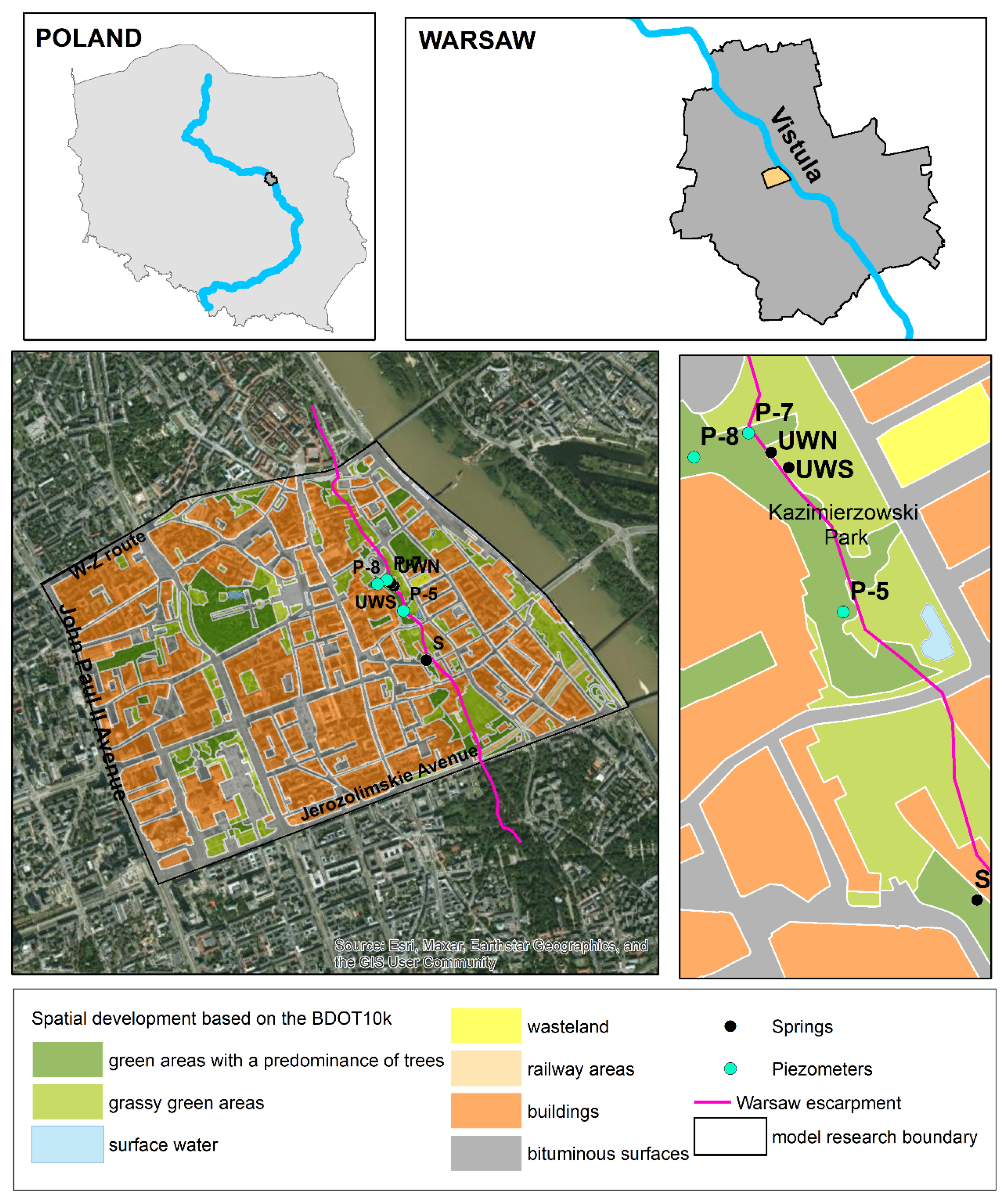
The study area is located in Warsaw’s Powiśle district, part of downtown. The study included the so-called University Springs (UWN—North University Spring, UWS—South University Spring), which are about 15 m apart and flowing from the lower part of the Warsaw escarpment around an elevation of 88.0 m a.s.l. Approximately 500 m to the south, in the vicinity of Dynasy Street, is an unlined spring (DYN), which was not tested before 2021. It drains the same aquifer as the University Springs. This aquifer was additionally sampled in 2025 in three piezometers located in the escarpment area. Groundwater from these boreholes has not previously been tested for chemical composition.
Figure 1 presents the location of the research area with the springs and piezometers that were sampled.
There is some historical information on spring rates, which have also been studied intermittently by various researchers. The South University Spring (UWS), in the 1960s, had a steady output of 9.0–11.0 dm
3/min [
22]. According to Mysiak and Nejfeld [
23], by the early 1970s, the output of this spring had decreased threefold (3.8–4.2 dm
3/min), while measurements from 1995 to 1996 (after housing reconstruction) showed an increase in average output to 7.5 dm
3/min. The North University Spring (UWN) was characterized by a more stable flow over time, but its outflow was much lower, averaging 1.3 dm
3/min [
22]. Measurements taken between 1997 and 2004 showed a decline in the flow rate of both springs to an average of 0.6 and 1.02 dm
3/min [
25,
27]. This period coincided with the construction of the first subway line, during which, between 2000 and 2002, the outflow from both springs disappeared completely [
26].
The thermal regime of the University Springs has undergone distinct transformations over time. Between 1841 and 1844, when Pusz (after [
21]) conducted water temperature studies on five Warsaw springs, the average water temperature of the University Springs was 8.7 °C (maximum 9.8 °C in August, minimum 6.9 °C in March). By the 1990s, the average temperature had increased by approximately 1–2 °C: for UWS, the average was 9.7 °C (maximum 11.8 °C, minimum 7.8 °C), and for UWN, the average was 10.7 °C (maximum 12.1 °C, minimum 5.7 °C) [
21]. Recent measurements from 2021 indicate a further increase in temperature, with the maximum recorded water temperatures in July reaching 17.1 °C for UWS and 17.3 °C for UWN.
Due to the specific nature of hydrogeological resource studies, the study area was defined based on the functionality of the hydrodynamic model and limited to an area of 4.12 km
2. The area consists of two geomorphological units—an upland region (Warsaw Plain) and a river valley (Middle Vistula valley). Terrain elevations vary from 78.7 m a.s.l. (the average water level of the Vistula River) to approximately 120 m a.s.l. on the upland. The most variable morphological element is the Warsaw Escarpment, which reaches a relative height of 25 m in the downtown section. It is a natural erosion feature formed during the interglacial period about 115,000–128,000 years ago. Today, several-meter-thick anthropogenic embankments, composed mainly of urban debris deposited after the end of World War II, contribute to the formation of the escarpment. The combination of the geomorphology and the geological structure results in diverse hydrogeological conditions, which were analyzed using geological and hydrogeological databases [
28]. The available data encompassed a total of 3007 boreholes with depths ranging from 0.5 to 83 m. The data outlined above served as the basis for constructing the GIS database.
The hydrogeological characterization showed that groundwater occurs within two aquifers in the Quaternary sediments (the subsurface aquifer and the deeper aquifer), as well as in the Oligocene sediments. The uppermost aquifer is composed of sands of varying granulations mixed with gravels of fluvioglacial or fluvial genesis, and sands containing silts of glacial genesis. In some areas, water can be found within deposits of embankments formed since the 15th century, as confirmed by studies conducted in various areas of Warsaw [
29]. The deeper Quaternary aquifer is classified as a second-order usable aquifer on the Hydrogeological Map of Poland (scale of 1:50,000), although its exploitation in the Warsaw area is significantly limited [
30]. The deeper aquifer—which has a partially confined water table—occurs just above the clay sediments of the Pliocene or the clay layers of the South Polish glaciation, and it is overlain by the clays from the Odra glaciation.
The Oligocene aquifer, formed within the marine sands containing glauconite, occurs at a depth of approximately 230 m. Due to this depth, it was reasonable to limit the model tests to groundwater flow within Quaternary formations, restricting the analysis to a depth of 70 m. The water table of the subsurface aquifer exhibits variable characteristics, being either unconfined or slightly confined. A characteristic feature of the upland part of the area is the local absence of aquifers within the vertical profile, as observed in 194 boreholes of the study. It was estimated that approximately 4.5% of the area consists of inactive blocks where groundwater is absent.
The area has undergone significant surface transformation due to the presence of dense urban development comprising buildings of various types. Historical buildings, primarily dating back to the 18th century, predominate, but structures from the 19th and 20th centuries are also present, alongside some modern constructions.
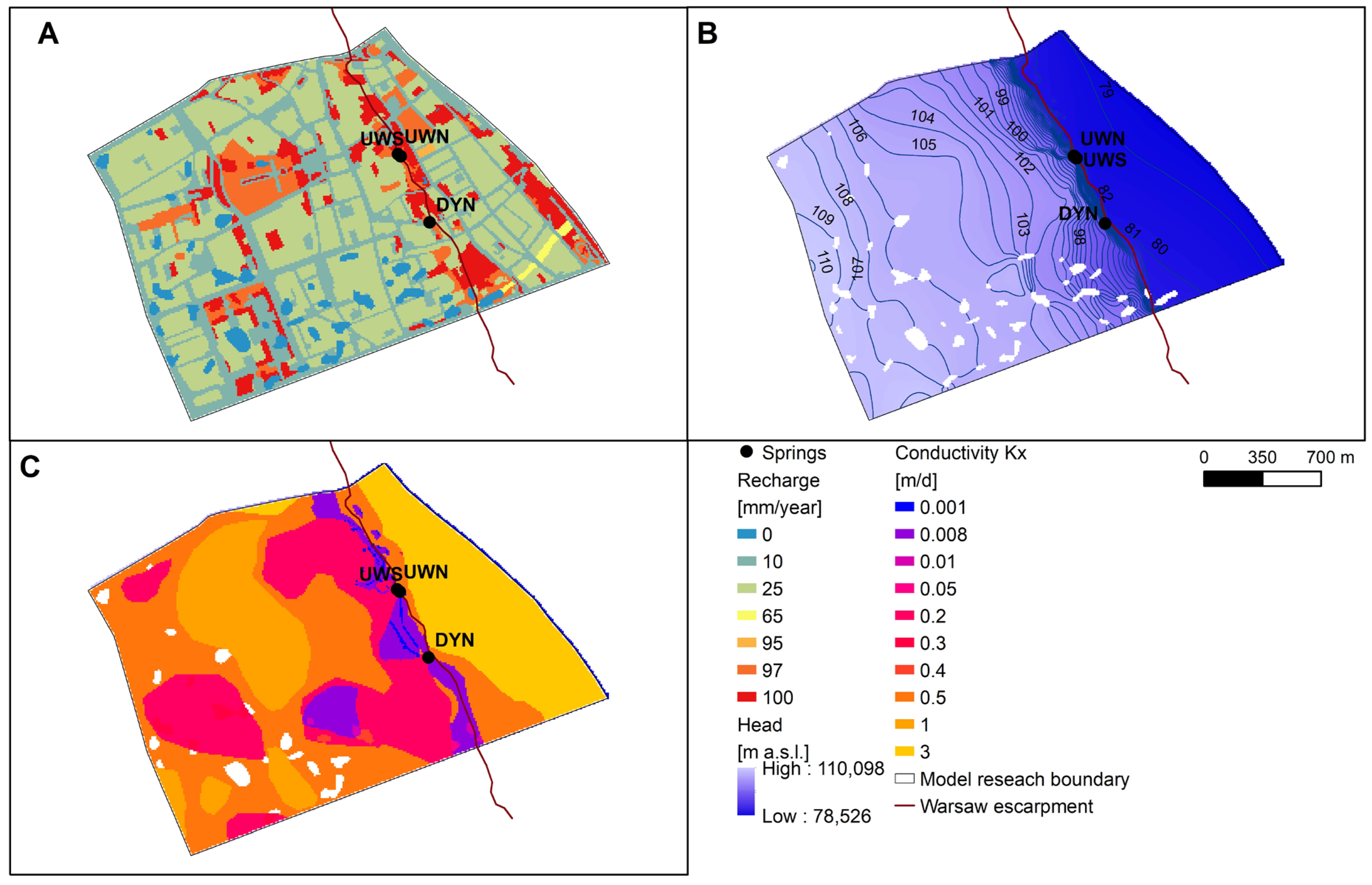
The development structure, shown in
Figure 1, is based on an analysis of data from GUGIK resources [
31] validated by satellite imagery and field observations. Seven land-use types were identified. The largest category by area is buildings (49.84%), followed by bituminous surfaces and pavements (30.44%). Green areas dominated by trees account for 7.41%, while grassy greens make up 11.11%. The remaining categories, such as surface water, wasteland, and railway areas, collectively constitute slightly more than 1%.
3. Materials and Methods
Hydrogeological studies were directed at determining the quantity and chemistry of water flowing from springs in Kazimierzowski Park in order to consider the possibility of their potential use in the urban space, but for a comprehensive characterization, it was also necessary to identify the chemistry of groundwater in the aquifer itself, so nearby piezometers were also sampled. The results were referred to the area of spring alimentation zones based on model studies.
3.1. Groundwater Conditions and Modeling
The conceptual model was developed through an assessment of the area’s hydrogeological conditions, from which a section of the aquifer system was delineated. The conditions include two aquifers within Quaternary formations. In addition, an aquifer occurs in Pliocene deposits at depths exceeding 230 m; however, this deeper aquifer does not significantly influence the analysis of water inflow to the springs, which is the primary focus of this study.
The shallow aquifer, encountered first at the land surface, occurs in formations characterized by great lithological diversity, resulting in areas with lower-permeability sediments or even regions with no flow [
28]. Its thickness is relatively limited and varies spatially. The second Quaternary aquifer is the deeper one, primarily isolated by glacial till, and its groundwater table stabilizes several meters below that of the shallow aquifer. Within the confines of the Vistula River valley, however, the two aquifer levels merge; although the water table remains unconfined, it is still relatively deep—ranging from 2 to 5 m—owing to direct drainage by the Vistula River. Groundwater contour maps indicate lateral inflow from the west and south, with flow directed eastward toward the Vistula River or northeast [
30].
Water exchange with the system’s surroundings occurs through infiltration recharge, lateral groundwater inflow and outflow, and direct drainage by the Vistula River. In this groundwater system, sources include recharge from the surface as well as lateral inflow along the south and west boundaries of both aquifers, while sinks consist of the Vistula River, springs, and a small portion of the north boundary in both aquifers.
The Vistula River serves as the primary drainage outlet for both aquifers. In this area, the renewability of water resources results not only from lateral inflow but also from infiltration recharge—even though, in urban zones, this process is hampered by widespread impervious surfaces. Moreover, the pressure difference between the aquifers suggests that seepage into deeper aquifers may occur in upland regions.
The specifics of a highly urbanized area usually preclude basing the flow model on natural hydrodynamic boundaries. In this case, the only natural boundary is the Vistula River, which is treated as a primary drainage base for both aquifers from the Quaternary strata. The remaining boundaries were set as artificial, which were established at an appropriate distance from the main object of study (springs) so as to exclude the direct influence of the applied boundary conditions.
Model tests were carried out in Visual ModFlow Flex 7.0 software, based on the finite difference algorithm [
32]. The model was made for steady-state filtration conditions, defined as the average annual hydrodynamic condition. The main objective of the model study was to determine the area of spring alimentation zones located above the Warsaw escarpment.
The area was divided into square computational blocks of Δx = Δy = 10 m, 236 rows and 312 columns, where the number of active blocks was 40,758.
The discretization of the area in the vertical direction included distinguishing 3 layers described in order from the top:
- -
First: The subsurface aquifer;
- -
Second: The level of boulder clays, local clay, and silt, constituting an aquitard layer; in the Vistula valley, the subsurface aquifer is connected with the deeper aquifer;
- -
Third: Deeper Quaternary aquifer.
The conceptual scheme and subsequent spatial discretization, along with the determination of the thickness of each layer, were established based on an analysis of archival data [
28]. The boreholes were drilled over a broad time range from 1948 to 2014, with 53% of them dating to the period 1972–1998. Despite the theoretically extensive database, there are currently only three piezometers in the area that continuously document the occurrence of the subsurface aquifer.
Within the study area, no direct information is available regarding key hydrogeological parameters, such as conductivity, effective porosity, or the yield rate of individual aquifers and aquitards. Therefore, estimated values derived from detailed lithological descriptions were assumed as initial data.
The magnitude of infiltration recharge was mapped using a second-type boundary condition, in which it is assumed that Q = constant. The amount of recharge was estimated to range between 10 and 100 mm/year, taking into account the average annual precipitation (
p), the runoff coefficient (ψ), which depends on the surface type and its degree of sealing [
31], which is a key factor in urban areas, and the infiltration rate (ω) depending on the lithology of subsurface formations [
33], as expressed in the following formula:
There is no groundwater extraction in the study area, but there are three springs at the base of the Warsaw Escarpment, which were mapped using a second-type point condition with a known discharge rate calculated as the average of own measurements taken between 2022 and 2025.
The type III condition mapped direct drainage through the Vistula River and lateral exchange through the model boundaries. The RIVER type III condition was set for the model cells simulating the Vistula River as the eastern boundary, providing the drainage base for both aquifers. After hydrogeological analysis, it was determined that the boundaries of the modeled area were open to water exchange with the surroundings on all sides for both aquifers. The southern and northern boundaries were drawn approximately perpendicular to the groundwater contours, suggesting that the exchange with the surroundings would be negligible compared to the inflow from the west. A Type III General Head Boundary (GHB) condition was used to represent these outer boundaries of the model.
3.2. Chemistry of Water from Springs and Piezometers
The current field research was conducted across six measurement sessions, three in 2021 and once each in 2024 and 2025. Each time, water samples were collected from three springs (UWN, UWS, DYN), and samples were also taken from three piezometers (P5, P7, and P8), as shown in
Figure 1. The values of temperature, pH, redox potential, oxygen content, and electrolytic conductivity (EC) of the water were measured directly in the field. A portable Elmetron CPC-411 multifunctional instrument with dedicated measuring electrodes was used for this purpose.
Chemical analyses of the collected samples were performed at the Environmental and Natural Hazards Research Center, part of the Research and Supervision Center in Lędziny in 2024 and 2025, and at the Wessling laboratory in 2021. Both laboratories are accredited by the Polish Accreditation Center (PCA AB 418).
The scope of chemical analysis included a total of 48 physical and chemical characteristics and dissolved components in water. The concentrations of major ions (HCO3, SO4, Cl, Ca, Mg, Na, K), second ions (NO3, NO2, NH4, PO4, Fe, Mn, Sr, Ba, SiO2), and metals (As, Al, Cd, Co, Cr, Mo, Ni, Pb, Zn), as well as non-ionic compounds (detergents) and hydrocarbon substances (polycyclic aromatic hydrocarbons (PAHs); volatile aromatic hydrocarbons (VOCs) such as benzene, toluene, ethylbenzene, and xylene (BTEX); polychlorinated biphenyls (PCBs), hydrocarbon oil index) were determined. The results of the chemical analyses were used to determine the hydrogeochemical types of the waters and graphically represent their composition and variations over time since 2021, as well as to compare them with the results of archival analyses.
Based on these findings, groundwater was assessed for its suitability for irrigation of vegetation in urban green areas. For this purpose, parameters such as EC, the percentage of sodium ions (%Na), and the sodium adsorption ratio (SAR) were used. The classification of irrigation based on SAR is primarily determined by the impact of sodium accumulation on soil physical properties, including the degradation of soil structure [
34]. SAR values are influenced by the relative concentrations of cations, and the reciprocal ratio of sodium to calcium and magnesium ions was calculated using equivalent concentration values:
It was assumed that when
SAR < 10, natural conditions for plants occur and natural conditions for plant growth are maintained, whereas when
SAR > 10, the harmful effects of salts on plant physiological processes and soil formation properties become apparent [
35,
36,
37].
The results of assessing the suitability of spring water for irrigating vegetation were visualized using Wilcox and Riverside diagrams.
4. Results
4.1. Hydrodynamic Modeling
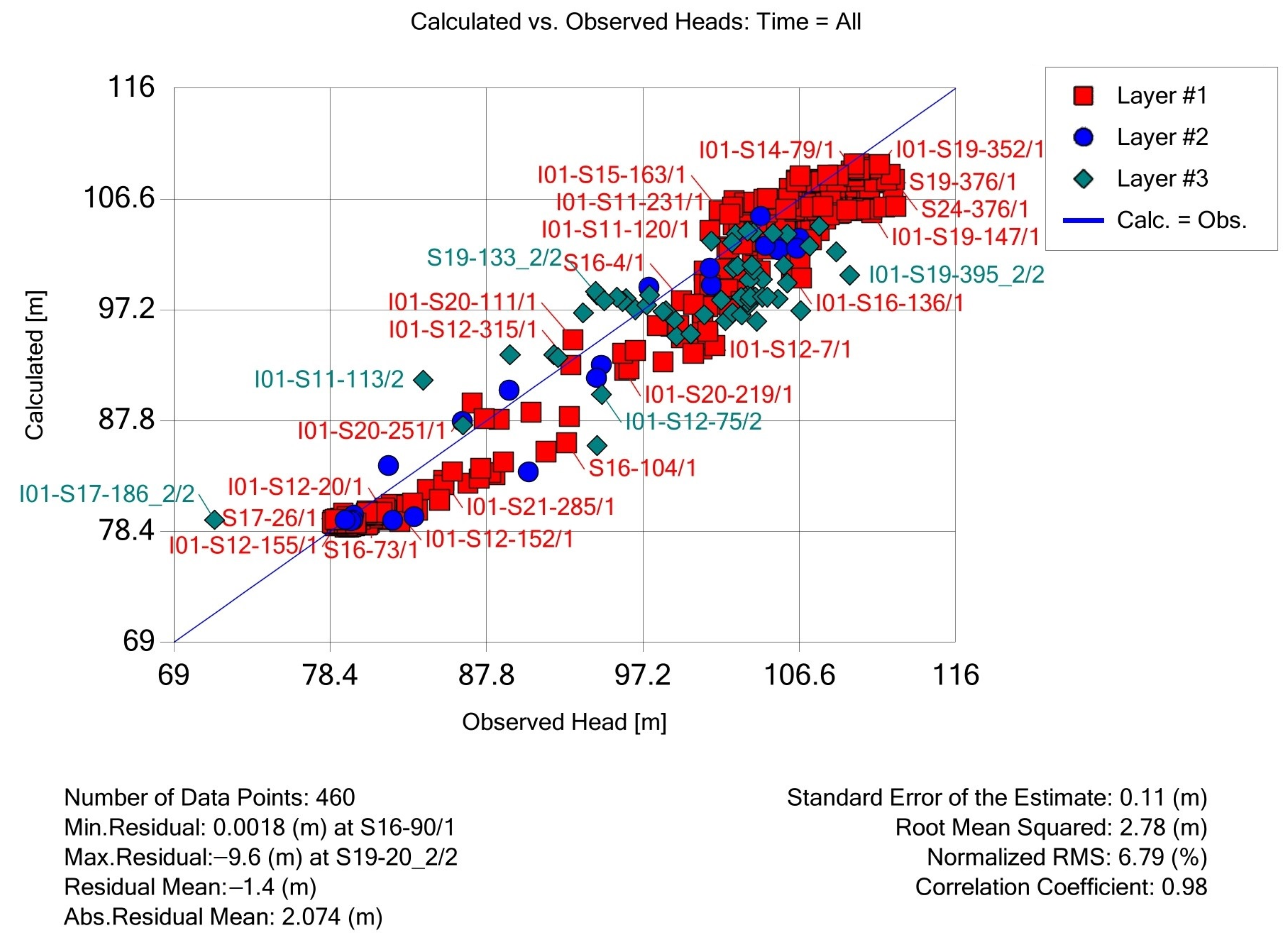
The process of calibrating the hydrodynamic flow model required solving the inverse task through the method of successive approximations. The obtained solution for the aquifer system state was validated by calibrating the heads at 460 points. As a result of the calibration, errors quantifying the correspondence between model calculations and input data at observation points were determined and are presented in
Figure 2. The maximum difference between the measured and calculated water table was −9.6 m, and the absolute average residual was 2.074 m. The calibration process was completed with an estimation error of 0.11 m and an absolute mean error of 2.78 m.
During the calibration process, the properties of the filtration field were adjusted, primarily by modifying conductivity values. The determined range for the subsurface aquifer varies between 0.001 and 3 m/d, with values exceeding 1 m/d occurring in the Vistula valley, below the escarpment. In the upland area, values predominantly range from 0.2 to 1 m/d. As shown in
Figure 3, the escarpment region stands out due to filtration conditions being restricted by the near-surface occurrence of clays of various origin (glacial, deluvial) and outcrops of Pliocene formations, which form a distinctive rift. Conductivity values in this area were determined at 0.008 m/d, locally even 0.001 m/d. Filtration conditions in the Vistula valley are less varied, although a higher proportion of the silty and sandy fraction was observed near the surface in some profiles.
The groundwater contour map reveals significant hydraulic gradients within the escarpment region, with the steepest gradients occurring between the UWS and DYN springs. A local watershed is formed here, separating the flow of water in the northeast and east directions, as illustrated in
Figure 3. The smallest gradients were recorded in the central upland region in the Saxon Park area, approximately 3‰, where flow conditions are optimal and impermeable layers are relatively scarce.
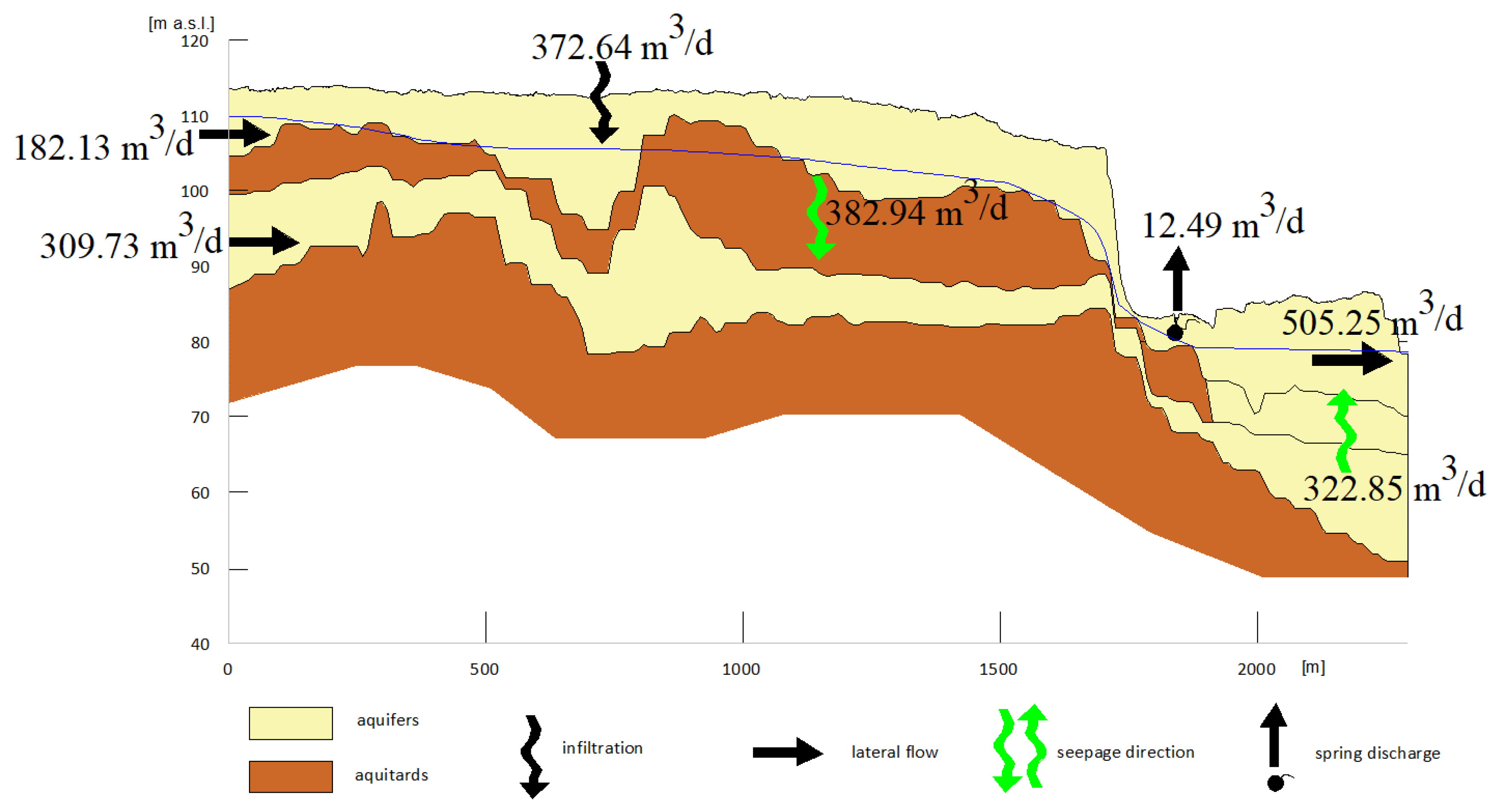
The study enabled the determination of the groundwater balance components, which are listed in
Table 1 and illustrated schematically in
Figure 4. The infiltration recharge of the subsurface aquifer was calculated at 372.64 m
3/d, accounting for 67% of the renewable resources in the area. The second component is lateral inflow, while the third is inflow from the lower aquifer in the river valley region. In the subsurface, aquifer balance is particularly notable, showing strong seepage through the aquitard into the deeper aquifer, which exceeds infiltration recharge (382.94 m
3/d). Only a small fraction of the total renewable resources of the subsurface aquifer is discharged via springs. For the lower aquifer, lateral inflows from the west are significantly higher (309.73 m
3/d), while upward seepage (322.85 m
3/d) occurs within the river valley region, where a substantial common aquifer has developed.
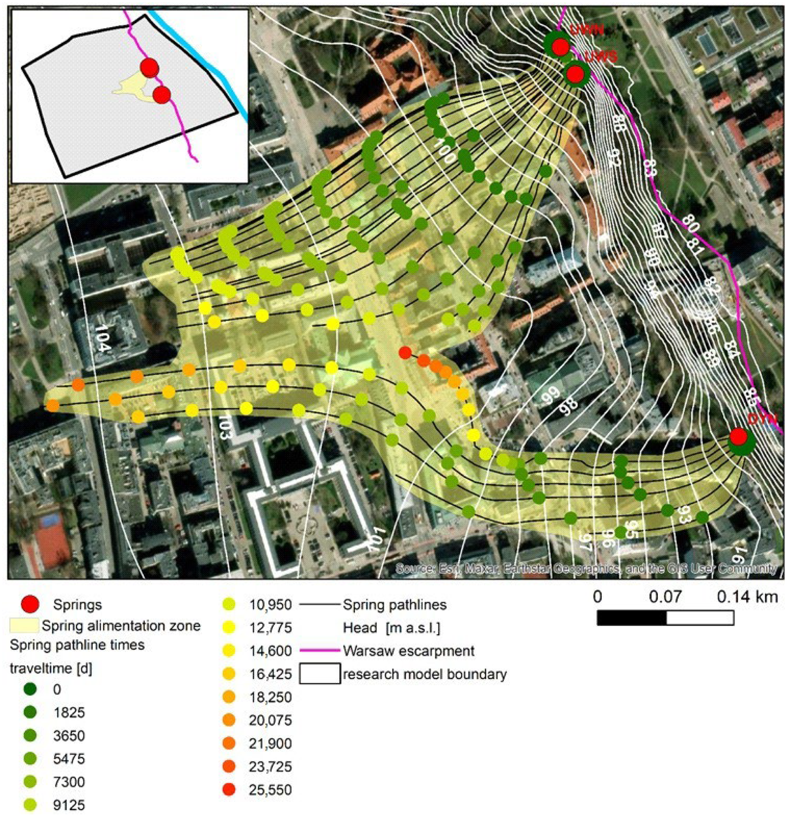
The alimentation zone of springs was determined using the MODPATH module. By tracking the water particles flowing within the three-dimensional model space, the size of the area, particle flow duration, and average velocity were calculated. Ten particle starting points were placed around each spring, as illustrated in
Figure 5.
Model studies revealed that inflow to the springs covers 2.64 ha for UWN, 5.09 ha for UWS, and 6.03 ha for the DYN spring. Basic statistics are provided in
Table 2. The extent of the area and the maximum distance from the springs were estimated at 760 m for DYN, while for UWN and UWS, it is slightly smaller—about 500 m. The average distance between the particle’s entry into the hydrogeological system and its discharge at the springs is approximately 340 m, which is considered relatively small. The average water flow time reaches 27.29 years for UWS, while for the other springs, it is slightly shorter. The maximum time is 70 years for the DYN spring. The maximum flow time for the DYN spring is 70 years. Studies indicate that the inflow process for the DYN spring is more complex, involving exchanges between the subsurface and deeper aquifers. The flow path is offset northward and includes infiltration into the shallow aquifer, followed by seepage into the deeper aquifer due to pressure differences between these two. Then, it seeps back into the upper aquifer. As a result, the inflow duration is significantly extended, reaching approximately 70 years, with other maximum values estimated at 33–43 years.
4.2. Chemistry of Water from Springs and Piezometers
The field measurements presented in
Table 3 indicate that groundwater from the springs had a high electrical conductivity (EC), ranging from 2519 to 3483 µS/cm, while water from the piezometers displayed significantly lower values (1722–2690 µS/cm). All samples showed either a weakly acidic or weakly alkaline reaction (pH from 6.40 to 7.7).
The chemical composition of the water from the studied springs differs significantly from that of the other Warsaw springs (approximately 10 across the city) and from the shallow Quaternary aquifer in other parts of the capital. These springs are the only ones in Warsaw where the predominant major ions are chloride, sulfate, and sodium.
A very high proportion of nitrate ions (>15% meq/dm
3) was observed in the water from the DYN spring. Additionally, in two sampling series conducted in 2021, elevated concentrations of arsenic, molybdenum, zinc, and substances from the PAH group (benzo(b)fluoranthene, benzo(g,h,i)perylene, benzo(k)fluoranthene, indeno(1,2,3-c,d),pyrene, benzo(a)pyrene, dibenzo(ah)anthracene, and ∑PAH) were detected, which indicates a strong anthropogenic transformation of the composition of the water [
38]. The remaining constituents, such as NO
2, NH
4, PO
4, Fe, Mn, Sr, Ba, and SiO
2, as well as metals, including Al, Cd, Co, Cr, Ni, Pb and substances of the hydrocarbon group (BTEX, hydrocarbon oil index, PCBs), were found to be within concentration limits permitted by Polish regulations for drinking water [
39].
Historically, the oldest fully documented and balanceable chemical analysis of Warsaw spring water is found in the work of Pich and Plochniewski [
23], which defined the hydrogeochemical types of water from the University Springs as follows: UWN as SO
4-HCO
3-Cl-Ca-Na, and UWS as SO
4-Cl-HCO
3-Ca-Na. At that time, their TDS measurements were also significantly higher than those recorded for other Warsaw springs. In 1964–1966, TDS, expressed as the average EC, was measured at 2970 μS/cm (UWN) and 3459 μS/cm (UWS). The average sulfate concentrations were 644 mg/dm
3 for UWN and 754 mg/dm
3 for UWS. These values classify the water under exposure class XA2, indicating increased aggressiveness toward concrete structures.
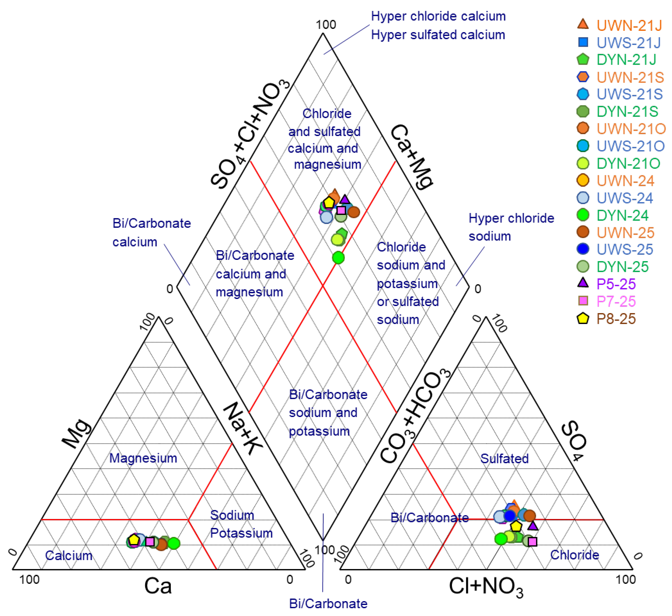
Between 1988 and 1990, a notable decrease in sulfate, chloride, and sodium concentrations was observed in water from University Springs. In contrast, recent studies conducted between 2021 and 2025 show a dominant presence for chloride and sodium ions, marking a shift from the chemical type recorded in the 1990s from HCO3-Cl-SO4-Ca to Cl-HCO3-SO4-Ca-Na and Cl-SO4-HCO3-Ca-Na.
The Dynasy spring (DYN), first examined in 2021, differs from the University Springs due to its lower sulfate content, while nitrates play a significant role in shaping its chemical type. Nitrate levels among anions exceed 15% meq/dm
3, leading to its classification as Cl-HCO
3-Ca-Na(+NO
3). A similar hydrogeochemical type was identified for groundwater samples from
p-5 and P7 piezometers: Cl-HCO
3-Ca-Na, despite their closer proximity to the University Springs. In contrast, the water from piezometer P8 is characterized by 32% nitrate among the anions (with a concentration of 160 mg/dm
3), resulting in its classification as NO
3-Cl-HCO
3-Ca-Na-Na, with nitrate as the dominant anion. All variations in hydrogeochemical types are visually represented in the Piper diagram, where major ion proportions influence the distribution of points, as shown in
Figure 6.
5. Discussion
In urban areas, groundwater chemistry is influenced not only by natural hydrogeological conditions but also by anthropogenic factors, which change dynamically over time, such as land use and pollution sources [
40,
41,
42]. Therefore, a key aspect of determining groundwater quality is to involve a detailed identification of hydrogeological conditions and to delineate recharge areas using a hydrodynamic model to provide a comprehensive characterization of the issue.
The long-term effects of urban pressures on groundwater are most pronounced in the oldest parts of the city [
43]. This phenomenon is also evident in the case of Warsaw, where transformations in the water chemistry of the springs in Kazimierzowski Park have been observed. Additional influencing factors include the construction of the Warsaw escarpment itself, which now contains anthropogenic soils (including rubble embankments). These modifications contribute to the ongoing degradation of both the quantity and quality of water draining through these springs. The technical condition of the spring enclosure is also unsatisfactory, with visible signs of corrosion and material deterioration (brick, concrete). Since these materials remain in constant contact with the water without protection, they can impact its chemical composition through dissolution and leaching of artificial substances.
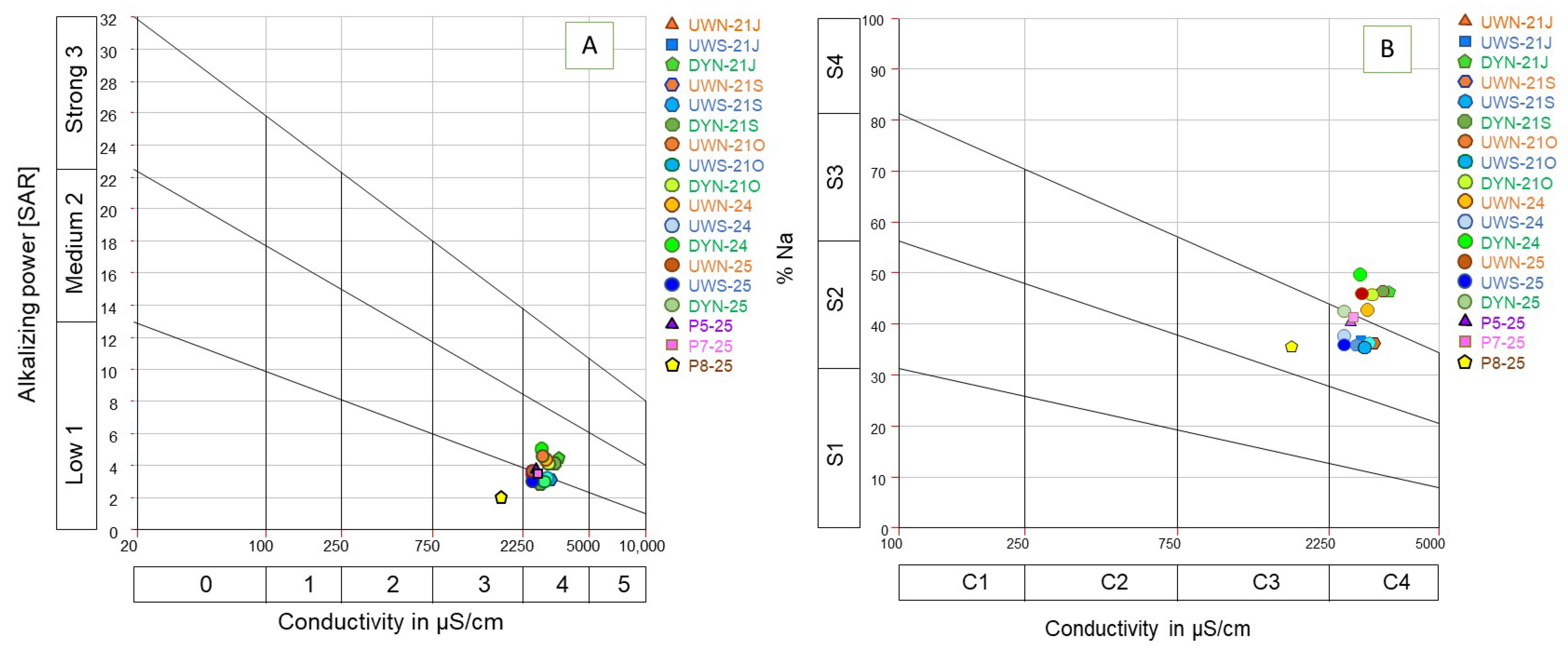
Groundwater flowing out of the Warsaw Escarpment is currently poorly managed, both in terms of the infrastructure and how the water is used. Any plans to reconstruct the outflows and use spring water for park irrigation or small recreational facilities must be verified based on its chemical status and suitability for the intended purposes. Water from all three springs currently exhibits poor chemical status due to its complex composition, indicating a high degree of anthropogenic transformation. As a result, the direct use of this water poses risks and may threaten park vegetation. The risk can be assessed by evaluating the water’s irrigation suitability, considering its electrical conductivity (EC) values and sodium adsorption ratio (SAR). SAR depends on the relative concentrations of cations, including the reciprocal ratio of sodium to calcium and magnesium, while EC and SAR values are analyzed together using the Riverside diagram.
Based on the EC results of the waters, it was determined that the UWN and UWS spring waters fall into the high-salinity category (750 < EC < 2250 µS/cm). Water in this category is unsuitable for irrigation on soils with limited drainage and poor leaching capacity. Therefore, it is recommended for use with plants that exhibit high salt tolerance. In the case of the DYN spring, the water belongs to the very high-salinity category (2250 < EC < 5000 µS/cm). It is not suitable for irrigation under normal conditions and can only be used occasionally under very special circumstances [
35,
44].
Another criterion for assessing the suitability of water for irrigating vegetation is the SAR. Alkaline risk to vegetation depends on the relative concentrations of cations and the reciprocal ratio of sodium to calcium and magnesium in the water. Sodium can be toxic to sensitive plants [
34]. The tested water demonstrated low to moderate alkalizing potential (SAR < 10), meaning that it could theoretically be used for irrigation across most soil types [
35,
36,
37].
Simultaneous analysis of EC and SAR values enables water classification according to the Riverside diagram [
45], which is presented in
Figure 7. Despite its relatively low SAR values, groundwater in this study exhibited high EC, with DYN and UWN spring water classified as M2C4 and S4C4 categories, indicating medium to poor water quality, where irrigation use should be limited. For light soils, additional drainage and leaching treatments or gypsum-based amendments may be necessary. The remaining samples were classified as L1C4 and S3C4, while the water from the P8 piezometer was classified as L1C3 and S3C3 categories. In this case, the geological structure of the park area below the springs presents additional challenges due to the presence of formations with poor permeability, including direct outcrops of Pliocene clay, which further restrict groundwater flow.
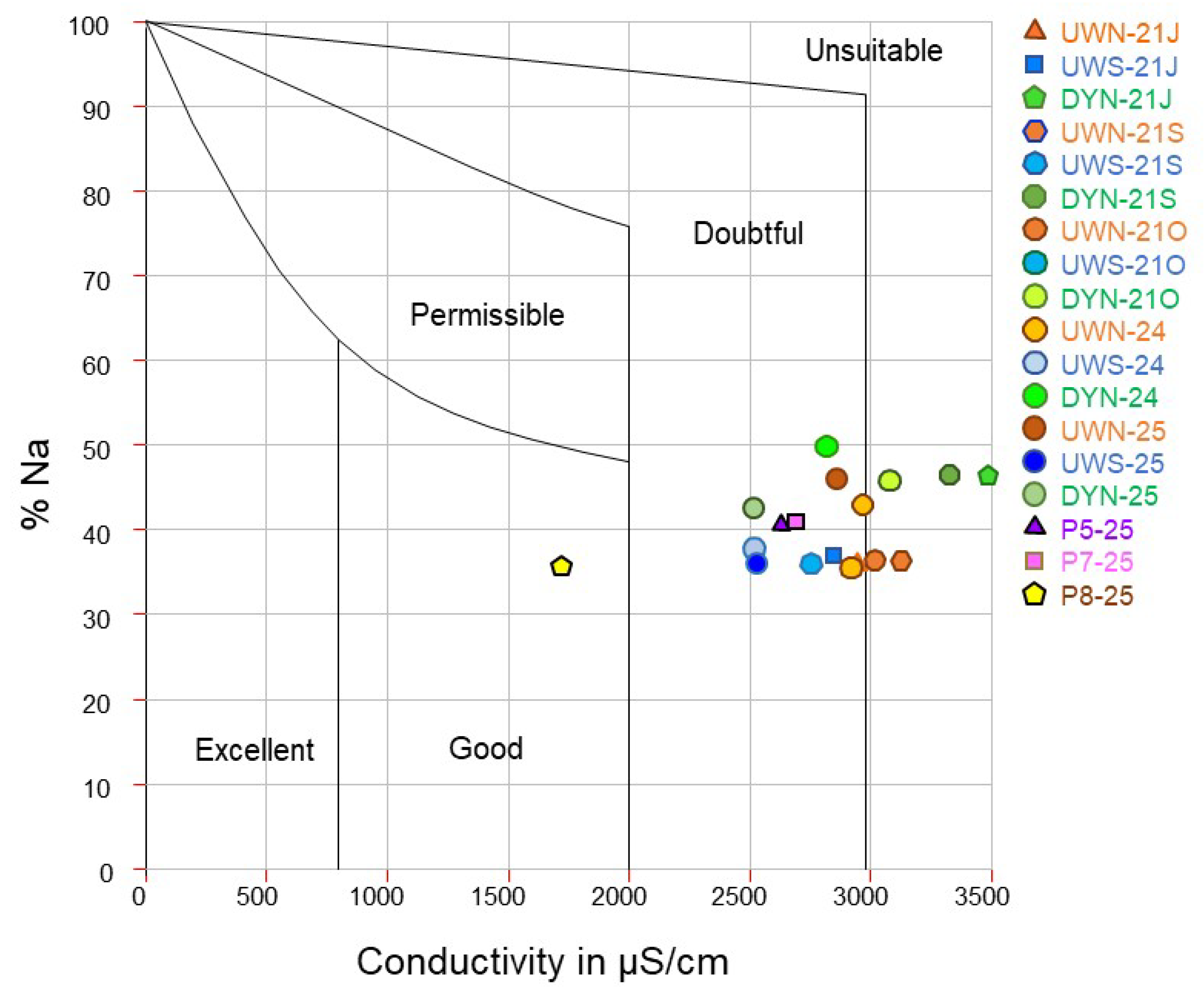
Another of the most commonly used methods for assessing the suitability of water for irrigation purposes is classification based on the Wilcox diagram [
34,
46]. The results of the calculation are presented in
Figure 8. Water was mostly classified as having questionable quality for irrigation use, five water samples (from UWN and DYN springs) were classified as water directly unsuitable for this purpose, and only one sample taken from the P8 piezometer showed good properties.
Numerous studies have shown that polluted waters negatively impact plant growth and physiological attributes [
47]. Therefore, when considering the use of the previously characterized waters for irrigation, alternative approaches should be evaluated. One potential solution is dilution with rainwater from surface runoff, which is generally regarded as being of relatively good quality compared to other urban surface water and groundwater [
47,
48,
49].
6. Conclusions
In urban areas, in addition to natural factors such as hydrogeological conditions, anthropogenic factors that change dynamically over the years, such as land use and potential pollutants present there, also have a significant impact on groundwater chemistry. Therefore, an important element in determining the quality of the groundwater studied was the detailed recognition of hydrogeological conditions and the determination of the spring alimentation zone using a hydrodynamic model.
The area of Warsaw’s downtown, which has been transformed by human activity for several hundred years, has had a major impact on the chemical composition of groundwater. Groundwater flowing from the highly urbanized area of the upland and discharging at the base of the escarpment is characterized by high EC (on average, 2820 µS/cm) and a dominant share of chloride, sulfate, and sodium ions. Shallow groundwater from Quaternary sediments under natural conditions is typically characterized by a simple ionic composition of the HCO3-Ca type. The sampled waters, however, exhibit a multi-ion composition, indicating anthropogenic transformation (types: Cl-SO4-HCO3-Ca-Na, Cl-HCO3-SO4-Ca-Na). In one of the springs, more than 15% nitrate share was observed, and in sample P8–25, the nitrate share reached 32% (NO3-Cl-HCO3-Ca-Na type). Pollutants such as PAHs, metals (As, Mo, Ni, Pb, Zn), and non-ionic surfactants further confirm the anthropogenic pressure. The high EC and high percentage of Na, averaging 34.3%, mean that the direct use of water from the sources for irrigation of urban vegetation or incorporation into active park recreational infrastructure appears to be risky.
While these levels do not always exceed thresholds for drinking water, they pose a potential risk when used without treatment, especially when considering long-term use for sensitive urban vegetation and recreational features. It is necessary to implement solutions such as dilution with rainwater, pre-treatment of water through aeration, desalination, or the introduction of appropriately resilient vegetation that would simultaneously perform the function of self-purification of the environment. An attempt to develop this wetland and currently unattractive area with hydrophilic plantings could make the area extremely attractive to local residents during the ongoing drought, and at the same time increase biodiversity with unique vegetation, which, in turn, contributes to an increase in the number of bird and aquatic animal species.
The proposed approach enables the implementation of protection of the entire recharge area and improvement of infiltration conditions through controlled recharge of the aquifer. This can significantly increase groundwater resources, which are very valuable in conditions of increasing water scarcity in cities. This study provides a baseline and a decision-making tool for city authorities, helping to determine whether local water resources can be rehabilitated or safely used following treatment.
The significance of the hydrogeological assessment lies in identifying the sources and pathways of contamination, recharge dynamics, and vulnerability of urban springs to anthropogenic pressures. This information is crucial for designing protection zones and recommending appropriate mitigation strategies, such as managed aquifer recharge or land-use restrictions.
Warsaw does have access to treated municipal water and deeper aquifers (e.g., Oligocene aquifer) that are of high quality. These sources are costly and less sustainable for non-potable purposes like irrigation. Re-evaluating the use of local shallow groundwater resources (such as springs), even partially or seasonally, is important in the context of climate adaptation.
In conclusion, while the current quality of spring water limits its direct use without intervention, the hydrogeological assessment remains essential for guiding urban ecological planning, protecting groundwater resources, and identifying future opportunities for the safe integration of spring water into green infrastructure systems.
This study not only documents the impact of urbanization on spring water quality but also ensures a universal framework for evaluating and integrating such water resources into urban green infrastructure systems. These findings support sustainable development strategies and adaptation to climate change in cities.


