Article

Key Technologies for Constructing Ecological Corridors and Resilience Protection and Disaster Reduction in Nearshore Waters

College of Hydraulic & Environmental Engineering, China Three Gorges University, Yichang 443000, China
*
Author to whom correspondence should be addressed.
Sustainability 2025, 17(12), 5234; https://doi.org/10.3390/su17125234
Submission received: 7 April 2025 / Revised: 17 May 2025 / Accepted: 29 May 2025 / Published: 6 June 2025

Abstract

:
The increase of population and economic activities has brought a series of problems to coastal areas, such as ecosystem pollution, overdevelopment, and climate change. The frequent occurrence of natural disasters is threatening the ecosystem of coastal areas, but also seriously affecting coastal populations. Under these circumstances, the construction of coastal ecological corridors, integrated with resilience protection and disaster reduction systems, has emerged as a critical strategy for enhancing the stability of ecosystems. This study combines big data analysis technology, remote sensing technology, and geographic information system (GIS) to establish a real-time dynamic monitoring for ecological corridors. The experimental results show that the average flow velocity in the ecological corridor area significantly slows down after a rainstorm compared to the control area. After the construction of the ecological corridor, the soil erosion rates decreased significantly, while air and water quality showed significant improvements. These findings show that ecological corridors improve the quality and protection efficiency of the ecological environment in coastal areas.

1. Introduction

As an important ecosystem and resource-rich area, nearshore waters host high levels of biodiversity and provide important ecosystem services for coastal communities. However, the coastal ecosystem [1,2] is facing challenges as a result of pollution, overdevelopment, and climate change. In this context, ecological corridors [3] have gained attention due to their multifunctional roles: they facilitate species migration, enhance ecosystem stability and resilience, and reduce the impact of natural disasters [4,5]. The traditional research and construction methods of ecological corridors focus on a single-objective perspective, usually emphasizing the function of ecological conservation [6]. Such narrow designs fail to address the complex ecological and social needs of nearshore areas, resulting in insufficient protection effectiveness—particularly under conditions of extreme weather and natural disasters. Moreover, traditional research tends to rely heavily on limited field survey data, lacking the comprehensive integration of big data analysis, remote sensing technology [7], and geographic information system (GIS) [8]. This restricts the capacity for real-time monitoring and accurate assessment of ecosystem dynamic changes. Furthermore, traditional methods often lack in-depth evaluation and continuous management of long-term benefits and potential risks. As a result, many ecological corridors experience a gradual degradation in functionality, failing to deliver sustained ecological or protective outcomes. Additionally, low public participation is also a problem, which significantly limits societal engagement and weakens long-term sustainability of the nearshore ecological corridor.
To address these limitations, this study proposes a comprehensive, scientifically grounded, and sustainable strategy for the design and implementation of ecological corridors in nearshore waters, which simultaneously emphasizes ecological protection and disaster prevention and reduction. Central to this strategy is a multi-objective optimization framework, which balances diversity conservation with resilience-building, ensuring that corridors are capable of withstanding extreme weather and natural disasters. This approach integrates advanced remote sensing, GIS, and big data analysis to establish a dynamic monitoring evaluation system. This system supports real-time data acquisition, performance tracking, and benefit assessment, offering a scientific basis for decision-making and adaptive management. It also enables the development of early warning and rapid response strategies to improve disaster risk reduction. This article emphasizes the importance of long-term performance evaluation under varying climatic and environmental conditions to ensure the intended functions throughout their life cycle. A public participation framework is also proposed, leveraging educational activities and community participation mechanisms to foster awareness, shared responsibility, and collaborative management. This study aims to offer innovative perspectives and practical guidance for the research and implementation of ecological corridors in nearshore areas, and promote the integrated development of ecological protection and disaster resilience.

2. Related Work

In recent years, the combined impacts of global climate change and intensified human activities have significantly influenced ecosystems, prompting growing scholarly interest in the construction of ecological corridors and the enhancement of resilience and disaster risk reduction strategies. Peng et al. [9] conducted a comprehensive study on urban ecological corridors using classification, systematic synthesis, and comparative analysis methods. They identified major shortcomings in existing practices and propose four key research directions to theoretically support the accelerated construction and improvement of ecological corridors in the context of China’s new urbanization. Their work provides a critical conceptual foundation for extending ecological corridor frameworks to the nearshore area. Van Der Windt et al. [10] analyzed early ecological corridor literature in the Netherlands, developing a conceptual framework that explains the rapid adoption of ecological corridors in both policy and practice. Their findings highlight the importance of designing ecological concepts both scientifically robust and socially applicable. In the Dnieper River corridor region, Solomakha et al. [11] studied the plants, animals, and natural habitats through extensive documentation of nature reserves [12,13] with the aim of conserving and restoring rare biodiversity and landscape heterogeneity. Their ecological classification work serves as a valuable reference for biodiversity assessments within ecological corridors.
With the advancement of technology, the application of remote sensing and GIS techniques has become central to modern ecosystem management. Niang et al. [14] used multi-temporal satellite data and the digital shoreline analysis system (DSAS) [15,16] to analyze the coastline dynamic [17,18] from 1965 to 2019 using statistical methods such as end point rate (EPR), linear regression rate (LRR), weighted linear regression (WLR), and net shoreline movement (NSM). They evaluated short-term and long-term coastal change trends and identified correlations with anthropogenic influences. These methodological advances support the real-time monitoring and evaluation framework proposed in this article, enabling the identification of potential corridor performance issues and enhancing long-term stability and protective effectiveness. Moreover, the importance of public participation [19,20] in the construction and maintenance of ecological corridors has also received widespread attention. Garcia et al. [21] reviewed the literature on river restoration projects, identifying key factors influencing public preferences and proposing a conceptual model to improve the acceptability and sustainability of such projects. Their research underscores the necessity of mobilizing public engagement and awareness, which is essential for ensuring the long-term benefits and sustainability of ecological corridors. Building on these studies, this article designs a comprehensive public participation strategy to strengthen public awareness, foster a sense of shared responsibility, and promote the co-construction and co-management of nearshore ecological corridors.

3. Construction of Ecological Corridors and Resilience Protection and Disaster Reduction

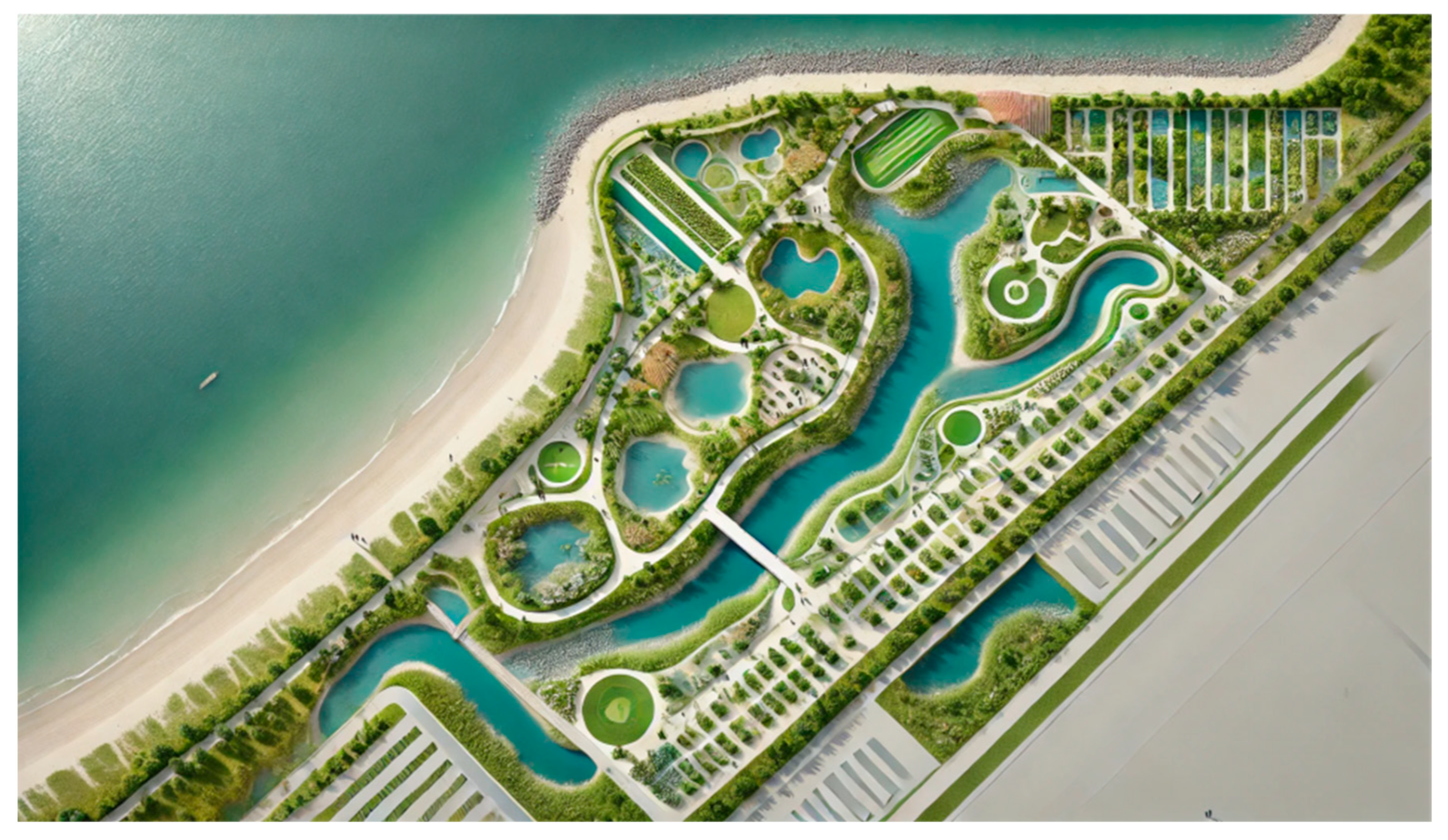
3.1. Construction of Ecological Corridor

The design and construction principles of ecological corridors need to start from the perspective of ecosystem protection and disaster prevention and reduction. The corridor should connect existing nature reserves and biodiversity hotspots to form a continuous ecological network [22,23], promoting species migration and gene exchange. During the design phase, the topography and natural landscape should be fully leveraged to support corridor functionality. Vegetation configuration, habitat restoration, and the preservation of ecological gradients are key strategies to enhance ecological functions. Considering the complex ecosystem of nearshore waters and the impact of human activities, it is imperative that corridor design accounts for the connectivity of diverse ecological units and the stability of the overall system, ensuring the corridor can adaptively respond to environmental changes and emergency events.
Figure 1 presents the conceptual framework of the ecological corridor design proposed in this study. This article uses multi-objective optimization [24,25] technology to build ecological corridors. The optimization objective is determined by using appropriate algorithms (Non-dominated Sorting Genetic Algorithm II, NSGA-II) to ensure the balance of biodiversity conservation, ecosystem services provision, and disaster risk reduction [24]. To support this, GIS and remote sensing technology are used to obtain and analyze the data of the marine ecological environment, enabling the generation of high-resolution basic maps. Considering all kinds of ecological factors, the mathematical model is used for optimization calculation to determine the optimal layout scheme of the ecological corridor. Additionally, risk assessment and resilience-oriented design are embedded into the modeling framework to ensure that the ecological corridors retain their protective capabilities under extreme weather conditions. Field investigation and expert reviews are used to verify and adjust the optimization scheme to ensure the feasibility and effectiveness in practice.
In the specific implementation phase, the integration of ecological protection and disaster prevention and reduction [26,27] functions follows a structured workflow beginning with ecosystem assessment and risk analysis. These assessments inform the formulation of ecological restoration and corridor construction projects that address multiple ecological and protective objectives. Key to successful implementation is the establishment of a dynamic monitoring and evaluation system that utilizes remote sensing technology and big data analysis [28]. This system enables real-time performance tracking, allowing for timely adjustments and management and adaptive responses to changing environmental conditions.

3.2. Technology Application

Advanced remote sensing technology and GIS methods play a crucial role in the construction of ecological corridors. High-resolution satellite remote sensing images are used to accurately identify and monitor land use changes and vegetation cover within ecological corridors, as shown in Figure 2.
Through multispectral and hyperspectral imaging techniques [29], detailed information about plant health status, soil moisture, and water distribution can be obtained. The GIS method provides comprehensive geographic information support through the integration and analysis of spatial data, helping to plan and design ecological corridors. High-resolution satellite imagery combined with GIS-based analysis enables the effective extraction of landscape patterns and the evaluation of corridor importance. For example, in Shenzhen, China, projection pursuit-based classification and landscape index analysis were used to identify and prioritize ecological corridors between control lines for urban ecological planning [30]. In this article, GIS is used to build a three-dimensional terrain model and an ecological network model to optimize the layout and function configuration of the corridor.
The process of establishing a dynamic monitoring and evaluation system needs to integrate a variety of technologies and methods. Real-time ecological data are obtained through high-resolution remote sensing images and unmanned aerial vehicle monitoring, and integrated and analyzed with GIS to form a complete ecological database. High-resolution remote sensing captures broad ecological parameters such as vegetation cover, land use change, and water quality. The real-time monitoring of environmental parameters of the ecological corridor is achieved through the use of Internet of Things (IoT) devices and sensor networks. IoT-based systems have been shown to enable real-time responses to changes in ecological corridors, enhancing conservation outcomes and reducing lag between disturbance and mitigation. Environmental sensors—such as those for temperature, humidity, soil moisture, air quality, noise, and water quality—are strategically placed throughout the corridor. These sensors form a Wireless Sensor Network (WSN) that collects data in real time [31]. In this study, basic water quality parameters—including pH, turbidity, and dissolved oxygen (DO)—were collected in real time from selected regions three times daily. The data were transmitted to cloud-based servers, where the Water Quality Index (WQI) was automatically calculated to facilitate continuous monitoring and assessment over a six-month period. The integration of heterogeneous data sources—including spatial, temporal, and sensor-based datasets obtained from IoT devices, remote sensing platforms, and GIS—necessitates a rigorous preprocessing pipeline. This pipeline involves systematic data cleaning, standardization, and fusion to ensure consistency and interoperability. To address the volume, velocity, and variety of such environmental data, scalable big data frameworks are employed for efficient storage, management, and parallel processing. Subsequently, machine learning models are utilized to extract and synthesize insights that characterize current environmental conditions. Furthermore, advanced analytical techniques such as clustering and dimensionality reduction are applied to detect and visualize critical patterns, including ecological degradation, pollution concentration zones, and landscape fragmentation hotspots [32]. Regular on-site investigation and expert evaluation are conducted to ensure the accuracy and scientific rigor of the monitoring system, and the monitoring strategies are dynamically adjusted and optimized according to the evaluation results, so as to improve the overall monitoring efficiency and decision support ability.
Big data analysis identifies key drivers and potential risks of ecosystem change by mining and analyzing monitoring data. The concept of the Area of Applicability (AOA) is employed in machine learning models to enhance the reliability of predictions by delineating the spatial or feature-space domains where the model’s training data provides sufficient coverage [33]. The integration of real-time dynamic monitoring with big data analytics enables the development of adaptive strategies that support the optimized design and long-term stability of the ecological corridor. This approach also enhances the effectiveness and efficiency of ecological management by facilitating informed decision-making and continuous system evaluation.

3.3. Public Participation

To achieve long-term maintenance and management of ecological corridors, multi-level and multi-channel participation is adopted to cover different age and social groups, achieving the goal of fully mobilizing public enthusiasm and protection awareness. Public surveys and symposiums are utilized to collect community feedback and incorporate public opinions into the ecological corridors planning process. These participatory tools enhance the scientific rigor and practical feasibility of the scheme. A detailed public participation plan should be developed, clarifying the time, method, and content of participation across different project phases.
Ecological protection lectures, environmental protection-themed exhibitions, and on-site visits to ecological corridors can be carried out to enhance public awareness of ecological protection and environmental responsibility. Multimedia and social media platforms can amplify outreach, disseminating real-time updates and knowledge related to the construction, operation, and maintenance of ecological corridors. At the community level, the formation of community-based environmental protection organizations, volunteer teams, and citizen science groups is encouraged in the regular organized activities, such as corridor cleaning, vegetation planting, and biological monitoring. These community-led initiatives help cultivate a sense of ownership, cohesion, and shared responsibility among residents.
Public involvement not only contributes human and resource resources, but also enhances the transparency and effectiveness of ecological corridor management through extensive social supervision. Engaged citizens are more likely to identify emerging challenges in corridor operation and propose practical solutions for improvement. Ultimately, public participation serves as a foundational pillar for the resilience and long-term sustainability of ecological corridors, while also contributing to the broader goal of sustainable development of ecological corridors.

4. Construction Effect of Ecological Corridors

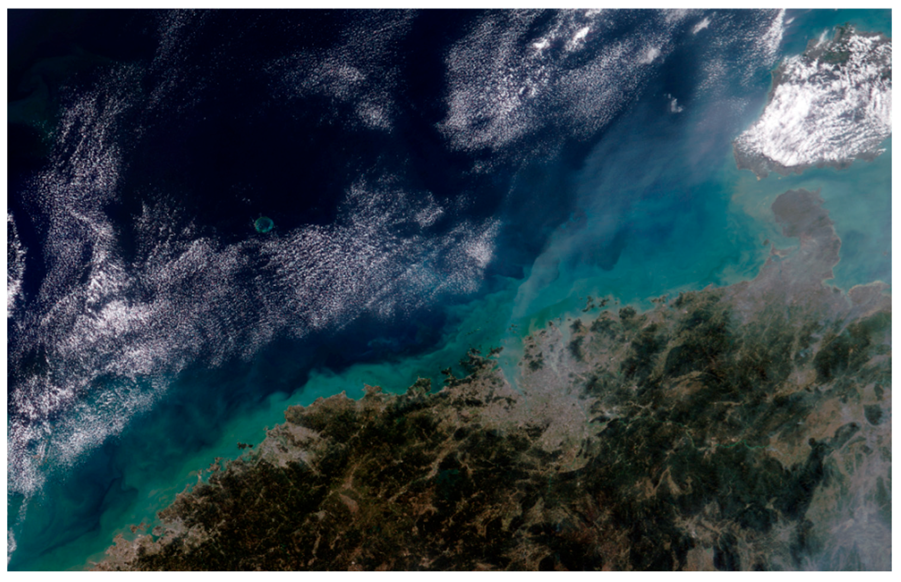
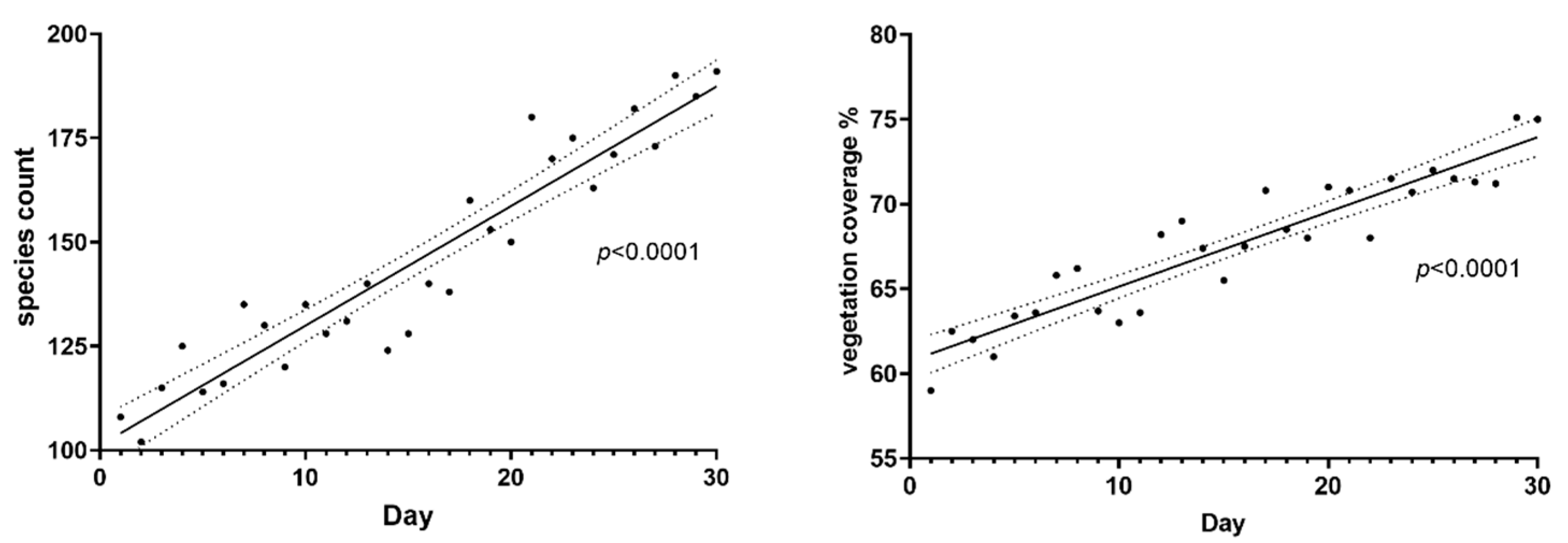
4.1. Operating State of Ecological Corridors

This study monitors the on-site performance of ecological corridors under various environmental conditions. The monitoring data collected demonstrate a significant increase in biodiversity within the corridor, along with effective protection of key habitats. These improvements contribute to maintaining overall ecosystem connectivity and functionality. Figure 3 shows the temporal changes in species count and vegetation coverage within the first 30 days following corridor construction.
Both species richness and vegetation coverage exhibit a statistically significance upward trend over time. The increase in vegetation not only enhances ecosystem stability but also strengthens its capacity for ecological protection. Collectively, the simultaneous improvement of these indicators confirms the positive outcomes of ecological corridor construction in terms of species conservation and vegetation restoration. These findings underscore the important role of ecological corridors in enhancing the environment quality of nearshore ecosystems.
To evaluate the ecological restoration effect of ecological corridor construction, the soil quality indicators of five selected regions were analyzed in detail, as shown in Table 1.
Table 1 shows that the content of soil organic matter in region C is as high as 5.7%, indicating that this area is suitable for plant growth. In terms of soil pH value, all regions are close to neutral, but the pH value of region C is 6.5, which is slightly acidic, indicating that this region is more suitable for specific types of plants. The difference of soil moisture content is also obvious, and the moisture content in region C is the highest, up to 24.7%, which indicates that the soil in this region has a strong ability to retain water, which is helpful to maintain the stability of the ecosystem.
This study uses the changes in tourism revenue, fishery revenue, and biodiversity conservation investment to evaluate the economic benefits, as shown in Table 2. These data help to understand the contribution of ecological corridors to local economic development.
It can be seen from Table 2 that the revenue from tourism and fishery is increasing year by year. From 2019 to 2023, the tourism revenue increased from CNY 12,000,000 to CNY 16,000,000, indicating that the construction of ecological corridors had a great positive economic impact on the tourism industry. Similarly, fishery revenue rose from CNY 8,000,000 in 2019 to CNY 10,000,000 in 2023, highlighting an improvement in aquatic ecosystem health and resource sustainability after the construction of the ecological corridor. Concurrently, investment in biodiversity conservation also showed an upward trend, from CNY 5,000,000 to CNY 5,800,000 during the same period. These figures collectively demonstrate that ecological corridors not only contribute to ecological protection, but also significantly enhance local economic benefits, achieving a win–win situation between economy and ecology.
To comprehensively assess the ecological health of ecological corridors, it is essential to monitor the quality of habitats, evaluate ecological functions, track environmental changes and refine conservation strategies accordingly. In this study, we analyze the bird diversity index in selected regions of the ecological corridor, and the relevant data is shown in Table 3.
According to Table 3, Region B exhibits the highest species richness, with 15 recorded bird species. The corresponding Shannon’s diversity index and Simpson’s diversity index are 1.60 and 0.79, respectively, indicating a high level of bird diversity in this region. Region C has the lowest species richness. The diversity index of each region shows that the construction of ecological corridors effectively promotes the distribution and diversity of bird species, helping to maintain ecological balance.

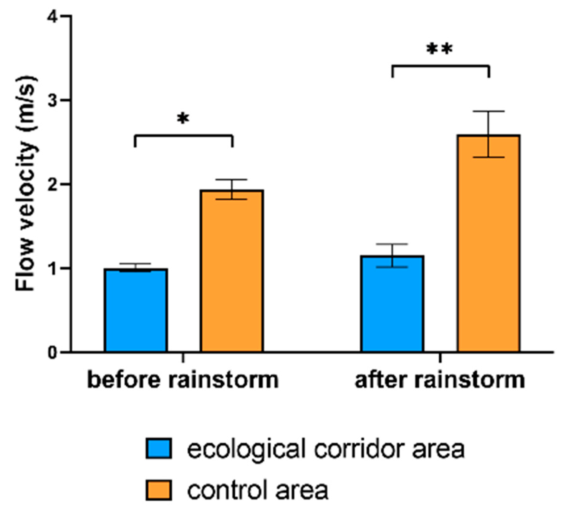
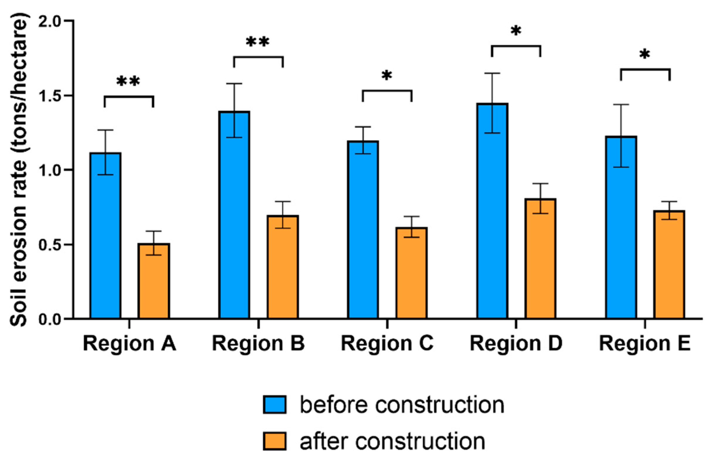
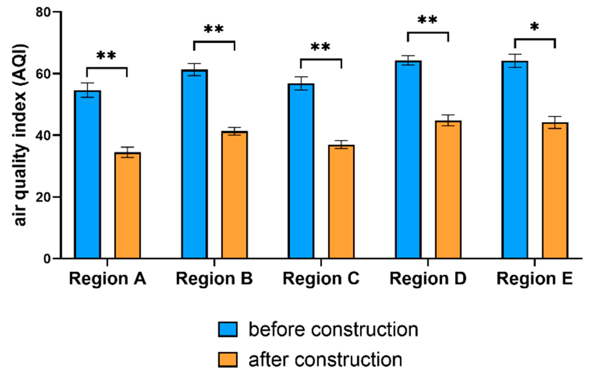
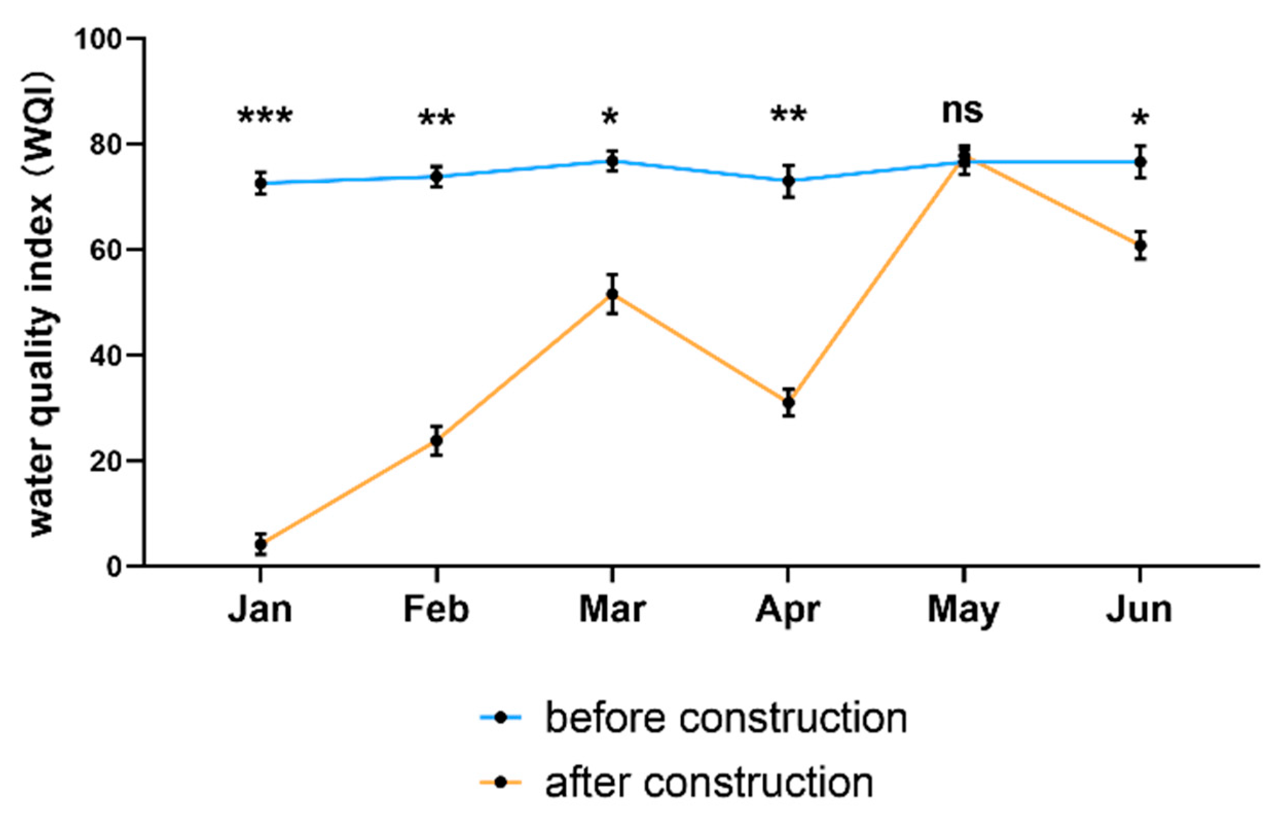
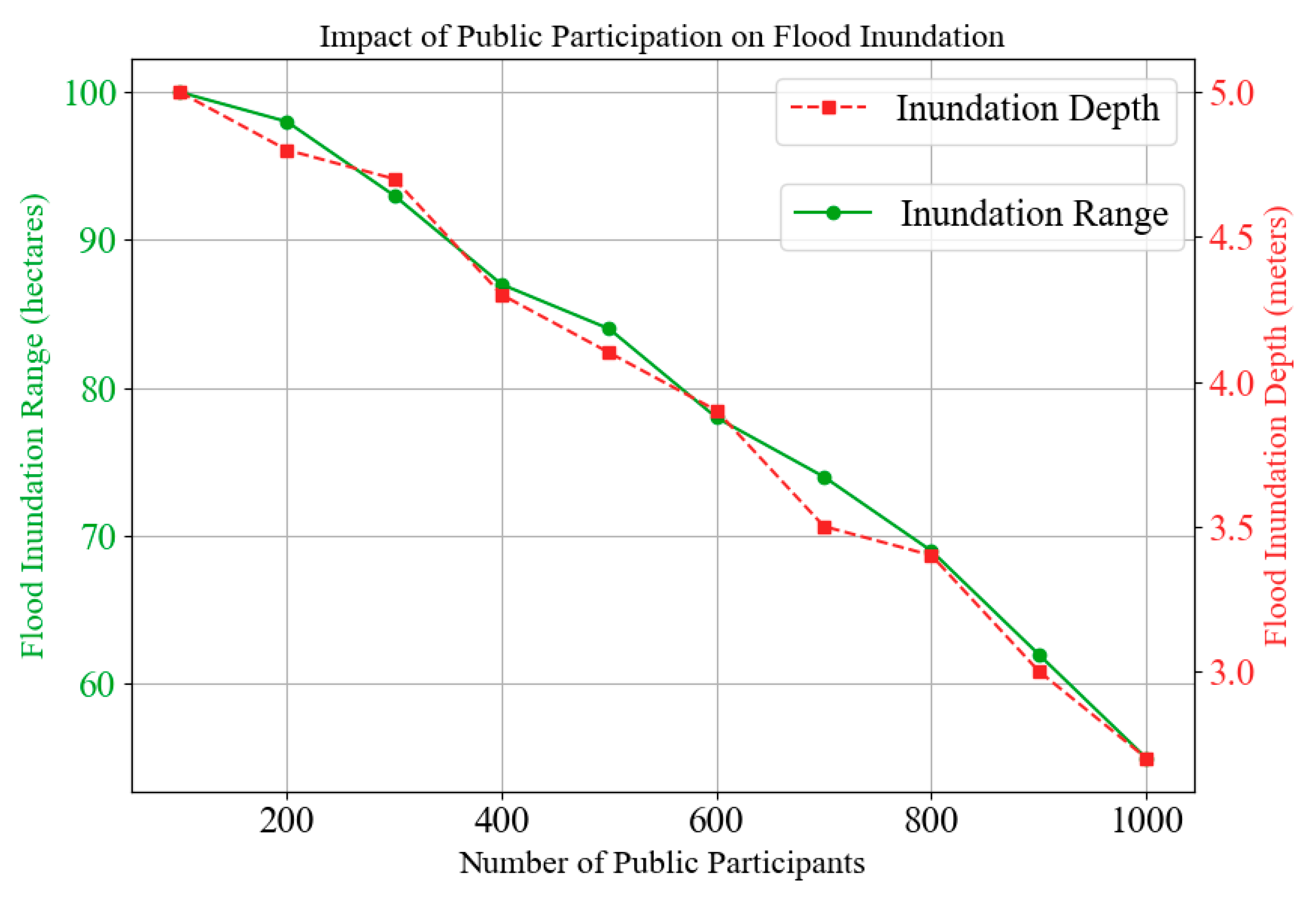
4.2. Protection Effectiveness

The flow velocity after a rainstorm directly affects the damage extent of a flood. Studying the change of flow velocity within the ecological corridor area and control area, before and after a rainstorm, provided valuable insights into the corridor’s flood mitigation effectiveness. Figure 4 shows the average flow velocity and its changes in the two areas before and after a rainstorm. The design of ecological corridors extends beyond biodiversity and ecological restoration, incorporating hydrological regulation as a core objective. Specifically, vegetation restoration and terrain optimization are employed to reduce surface runoff velocity, thereby enhancing the system’s protection function. The observed significant reduction in post-rainstorm flow velocity within the ecological corridor area demonstrates its capacity to dampen hydrological impacts and mitigate flood intensity. These results confirm that ecological corridors serve not only as ecological infrastructures but also as effective measures for enhancing climate resilience and disaster risk reduction in vulnerable landscapes.
The soil erosion rate directly affects the stability of the ecosystem. In order to evaluate the soil and water conservation benefits of the ecological corridor, this article compares the soil erosion rates of five areas before and after the construction of the ecological corridor, as shown in Figure 5.
Soil erosion rate is a key indicator of ecosystem stability, as excessive erosion can lead to habitat degradation and reduced land productivity. To assess the soil and water conservation benefits of ecological corridor construction, this study compared the soil erosion rates across the selected five regions before and after the implementation of the ecological corridors (Figure 5). The data clearly show that soil erosion rates in all regions decreased significantly following the construction of the ecological corridors. This outcome indicates that the construction of ecological corridors not only plays a critical role in mitigating soil erosion, but also contributes substantially to the protection and restoration of ecological environments. These findings provide compelling evidence of the effectiveness of ecological corridors as a nature-based solution for environmental protection and disaster risk reduction, underscoring the urgency and importance of adopting ecological engineering interventions in coastal waters.
Figure 6 shows the changes in the air quality index across the selected regions before and after the construction of the ecological corridors providing a basis for evaluating their effectiveness in enhancing air quality. While ecological corridor design traditionally emphasizes terrestrial habitat connectivity and biodiversity restoration, it also plays a critical role in atmospheric environmental improvement. This is achieved through increased vegetation coverage, which facilitates pollutant absorption and carbon sequestration, and through the reduction of localized pollution sources. The results shown in Figure 6 reveal a significant improvement in air quality following corridor construction. These findings underscore the multifunctional value of ecological corridors, demonstrating their contribution not only to ecological stability and landscape restoration, but also to the improvement of air quality.
The changes in water quality index (WQI) serve as an important indicator of the ecological condition and degree of improvement in the aquatic environment. Figure 7 compares the monthly WQI before and after the construction of the ecological corridor, enabling an assessment of their impact on water quality restoration. The results indicate that the construction of ecological corridors not only contributes to terrestrial rehabilitation, but also plays a vital role in protecting and improving water quality.
Figure 7 highlights a notable improvement in WQI following corridor construction, particularly during months with fewer rainstorms.
However, during months with frequent rainstorms—notably in May—no statistically significant difference in WQI was observed, likely due to increased stormwater runoff and sediment load temporarily overwhelming the corridor’s buffering capacity. These findings confirm that ecological corridors provide both short-term and sustained improvement in water quality, emphasizing their value as an integrated solution for land–water ecosystem management.

5. Discussion on the Application of Ecological Corridors

5.1. Comprehensive Benefits of Ecological Protection and Disaster Prevention and Reduction

Ecological corridors have shown significant comprehensive benefits in ecological protection and disaster prevention and reduction. Compared to conventional methods that often focus narrowly on ecological protection, ecological corridors not only effectively connect fragmented habitats, and promote species migration, but also improve the stability and restoration ability of ecosystems through multi-objective optimized design. In terms of ecological protection, the construction of ecological corridors significantly enhances biodiversity, ensures the conservation of key habitats, and maintains the overall connectivity and functional integrity of ecosystems. In contrast, traditional methods often emphasize ecological protection functions, but overlook the complex ecological and social needs of nearshore waters, resulting in limited effectiveness under conditions of extreme weather and natural disasters.
From the perspective of disaster prevention and reduction, ecological corridors effectively improve the regional soil and water conservation capacity, reducing soil erosion and mitigating the impact of floods through scientific design and ecological restoration. Coastal wetland corridors slow runoff and increase sedimentation, which helps in shoreline stabilization and water purification [32]. During rainstorm events, the average increase in water flow velocity within the ecological corridor area is significantly lower than that in control areas. This indicates the corridor’s capacity to moderate hydrological responses, reduce peak runoff, and diminish flood-related damage. The significant decrease in soil erosion rates following corridor construction highlights the effectiveness of vegetation restoration and terrain optimization in stabilizing the landscape and enhancing ecological resilience.
The incorporation of advanced remote sensing technology and big data analysis enables the establishment of a real-time dynamic monitoring and evaluation system, supporting continuous performance assessment and evidence-based decision-making. Results indicate sustained improvements in water quality, with significant gains even during non-rainy periods, and a measurable improvement in air quality. These comprehensive benefits demonstrate that ecological corridors have superior performance over traditional methods in ecological protection and disaster prevention and reduction.

5.2. Advantages and Disadvantages of Technology Application

Advanced technologies demonstrate outstanding application effects in the design, construction, and management of ecological corridors. High-resolution remote sensing images and GIS methodologies allow for highly accurate identification and monitoring of land use changes and vegetation dynamics within ecological corridors. Furthermore, multi-spectral and hyperspectral imaging technologies provide detailed information on plant health, soil moisture, and water distribution pattern, thereby supporting the optimization of corridors layout and functional zoning. A key innovation is the deployment of a real-time dynamic monitoring and evaluation system, which leverages IoT sensors, big data analysis, and machine learning algorithms to assess the operational status, performance metrics, and ecological benefits of the corridor. This system provides continuous feedback to ensure long-term stability, enhance adaptive management, and facilitate early warning in response to environmental changes.
In addition, the integration of a public participation framework strengthens the social sustainability of ecological corridors. By encouraging multi-level and multi-channel engagement, such initiatives foster greater public awareness of ecological protection, promote community responsibility, and support the long-term stewardship of the corridors.
Although the application of technology achieves significant results, it still faces many challenges and there is room for improvement. Remote sensing technology and GIS methods often require a large amount of computational resources and professional technical support in data processing and analysis. These high costs and complex operations may hinder their scalability and accessibility in resource-constrained regions. The effectiveness of the dynamic monitoring system relies on robust and reliable sensors and data communication networks. Limited network coverage or sensor malfunctions may compromise data accuracy and timeliness. The success of public participation schemes is influenced by the awareness, motivation, and long-term commitment of local communities. Sustaining public enthusiasm and ensuring active involvement remains a sociocultural and managerial challenge. The long-term assessments of technological applications are still constrained by the need for extended monitoring periods and large-scale data accumulation. This is essential for validating the effectiveness and sustainability of technological interventions.

5.3. Effectiveness of Public Participation

Public participation shows significant effects in the resilience protection and disaster reduction of ecological corridors. Through extensive publicity, educational activities, and community participation mechanisms, the public’s awareness of disaster prevention and reduction is significantly enhanced. The multi-level public participation approach not only fosters greater awareness and acceptance of ecological corridors among community members, but also stimulates their active involvement in the face of natural disasters. The effect of public participation on resilience protection and disaster reduction of ecological corridors is shown in Figure 8.
Figure 8 illustrates that with the increase in the degree of public engagement, the inundation area markedly decreases from 100 hectares to 55 hectares, while the inundation depth decreases from 5.0 m to 2.7 m. These results underscore that public involvement serves as a critical pillar for disaster risk reduction. The contribution of community members is particularly valuable in corridor maintenance and emergency response, especially during extreme weather and natural disasters.

6. Conclusions

Coastal areas face severe ecological challenges due to human activities and climate change. In this context, ecological corridors enhance the stability and resilience of ecosystems by connecting fragmented habitats. Traditional methods, due to their excessive reliance on field survey data, often lack the application of remote sensing technology and GIS, making it difficult to monitor the dynamic changes of ecosystems in real time. This study proposes a comprehensive ecological corridor construction framework that integrates both ecological conservation and disaster prevention and reduction functions. A dynamic monitoring and evaluation system is established by the application of remote sensing technology, big data analysis, and machine learning algorithms. This system can monitor the operating state of ecological corridors in real time and provide a robust scientific basis for adaptive management and policy decision-making. Research shows that ecological corridors show outstanding performance in enhancing biodiversity, improving water and air quality, and enhancing protection effectiveness. The design of public participation enhances the protection awareness and participation enthusiasm of residents through publicity, education, and community activities, ensuring the long-term benefits and sustainability of ecological corridors. Ecological corridors show substantial capacity to absorb and buffer the impacts of extreme weather and natural disasters, thus validating their role as an integrated solution for ecological protection and disaster prevention and reduction. This study offers novel insights and practical approaches for applying ecological corridors in nearshore waters, advancing the synergistic development of ecological restoration and disaster risk reduction efforts. Ultimately, through systematic monitoring and long-term performance evaluation, ecological corridors lay the groundwork for building resilient, adaptive, and ecologically sound coastal communities in the face of growing environmental challenges.

Author Contributions

Methodology, H.Q. and Y.Y.; Investigation, H.Q.; Resources, Y.Y.; Writing—original draft, H.Q.; Writing—review & editing, H.Q. and Y.Y.; Supervision, Y.Y.; Funding acquisition, Y.Y. All authors have read and agreed to the published version of the manuscript.

Funding

The work was supported by Mechanism of Atmospheric active iodide emission and Its Effect on Atmospheric Oxidation in Coastal Waters of South China (NSFC 42175118).

Institutional Review Board Statement

Not applicable.

Informed Consent Statement

Not applicable.

Data Availability Statement

The original contributions presented in this study are included in the article. Further inquiries can be directed to the corresponding author.

Conflicts of Interest

There are no potential competing interests in our paper, and all authors have seen the manuscript and approved its submission to your journal. We confirm that the content of the manuscript has not been published or submitted for publication elsewhere.

References

  1. St. Pierre, K.A.; Oliver, A.A.; Tank, S.E.; Hunt, B.P.; Giesbrecht, I.; Kellogg, C.T.; Jackson, J.M.; Lertzman, K.P.; Floyd, W.C.; Korver, M.C. Terrestrial exports of dissolved and particulate organic carbon affect nearshore ecosystems of the Pacific coastal temperate rainforest. Limnol. Oceanogr. 2020, 65, 2657–2675. [Google Scholar] [CrossRef]
  2. Shaffer, J.A.; Munsch, S.H.; Cordell, J.R. Kelp forest zooplankton, forage fishes, and juvenile salmonids of the northeast pacific nearshore. Mar. Coast. Fish. 2020, 12, 4–20. [Google Scholar] [CrossRef]
  3. Shen, J.; Wang, Y. An improved method for the identification and setting of ecological corridors in urbanized areas. Urban Ecosyst. 2023, 26, 141–160. [Google Scholar] [CrossRef]
  4. Saeed, S.A.; Gargano, S.P. Natural disasters and mental health. Int. Rev. Psychiatry 2022, 34, 16–25. [Google Scholar] [CrossRef]
  5. Obeagu, E.I.; Obeagu, G.U. Mental Health and Psychosocial Effects of natural disaster on HIV Patients. Asian J. Dent. Health Sci. 2024, 4, 38–44. [Google Scholar] [CrossRef]
  6. Posthuma, L.; van Gils, J.; Zijp, M.C.; van de Meent, D.; de Zwart, D. Species sensitivity distributions for use in environmental protection, assessment, and management of aquatic ecosystems for 12,386 chemicals. Environ. Toxicol. Chem. 2019, 38, 905–917. [Google Scholar] [CrossRef]
  7. Wang, X.Y.; Wu, Y. Water quality monitoring and evaluation using remote sensing techniques in China: A systematic review. Ecosyst. Health Sustain. 2019, 5, 47–56. [Google Scholar] [CrossRef]
  8. Ersad, A.I. Implementasi Geographic Information System Sebagai Media Pelaporan Kerusakan Jalan. J. Inform. Rekayasa Perangkat Lunak 2021, 2, 526–533. [Google Scholar] [CrossRef]
  9. Peng, J.; Zhao, H.; Liu, Y. Urban ecological corridors construction: A review. Acta Ecol. Sin. 2017, 37, 23–30. [Google Scholar] [CrossRef]
  10. Van Der Windt, H.J.; Swart, J.A.A. Ecological corridors, connecting science and politics: The case of the Green River in the Netherlands. J. Appl. Ecol. 2008, 45, 124–132. [Google Scholar] [CrossRef]
  11. Solomakha, I.V.; Konishchuk, V.V.; Mudrak, O.V.; Mudrak, H.V. A Study of the Emerald Network objects in Ukrainian Forest-Steppe of Dnieper ecological corridor. Ukr. J. Ecol. 2020, 10, 209–218. [Google Scholar]
  12. Miara, M.D.; Souidi, Z.; Benhanifa, K.; Daikh, A.; Hammou, M.A.; Moumenine, A.; Sabi, I.H. Diversity, natural habitats, ethnobotany and conservation of the flora of the Macta marches (North-West Algeria). Int. J. Environ. Stud. 2021, 78, 817–837. [Google Scholar] [CrossRef]
  13. Mohamed, A.; DeClerck, F.; Verburg, P.H.; Obura, D.; Abrams, J.F.; Zafra-Calvo, N.; Rocha, J.; Estrada-Carmona, N.; Fremier, A.; Jones, S.K.; et al. Securing Nature’s Contributions to People requires at least 20–25%(semi-) natural habitat in human-modified landscapes. One Earth 2024, 7, 59–71. [Google Scholar] [CrossRef]
  14. Niang, A.J. Monitoring long-term shoreline changes along Yanbu, Kingdom of Saudi Arabia using remote sensing and GIS techniques. J. Taibah Univ. Sci. 2020, 14, 762–776. [Google Scholar] [CrossRef]
  15. Baig, M.R.I.; Ahmad, I.A.; Shahfahad; Tayyab, M.; Rahman, A. Analysis of shoreline changes in Vishakhapatnam coastal tract of Andhra Pradesh, India: An application of digital shoreline analysis system (DSAS). Ann. GIS 2020, 26, 361–376. [Google Scholar] [CrossRef]
  16. Raj, N.; Gurugnanam, B.; Sudhakar, V.; Francis, P.G. Estuarine shoreline change analysis along The Ennore river mouth, south east coast of India, using digital shoreline analysis system. Geod. Geodyn. 2019, 10, 205–212. [Google Scholar]
  17. Isaac, A.; Adu-Boahen, K.; Dadson, I.Y. Spatio-Temporal Shoreline Movement of the Afram River in Ghana: The Application of Endpoint Rate and Net Shoreline Movement. J. Soc. Sci. (JoSS) 2023, 2, 623–638. [Google Scholar] [CrossRef]
  18. Meilianda, E.; Mauluddin, S.; Pradhan, B.; Sugianto, S. Decadal shoreline changes and effectiveness of coastal protection measures post-tsunami on 26 December 2004. Appl. Geomat. 2023, 15, 743–758. [Google Scholar] [CrossRef]
  19. Araos, M. Democracy underwater: Public participation, technical expertise, and climate infrastructure planning in New York City. Theory Soc. 2023, 52, 1–34. [Google Scholar] [CrossRef]
  20. McCarron, A.; Semple, S.; Braban, C.F.; Swanson, V.; Gillespie, C.; Price, H.D. Public engagement with air quality data: Using health behaviour change theory to support exposure-minimising behaviours. J. Expo. Sci. Environ. Epidemiol. 2023, 33, 321–331. [Google Scholar] [CrossRef]
  21. Garcia, X.; Benages-Albert, M.; Buchecker, M.; Vall-Casas, P. River rehabilitation: Preference factors and public participation implications. J. Environ. Plan. Manag. 2020, 63, 1528–1549. [Google Scholar] [CrossRef]
  22. Merz, E.; Saberski, E.; Gilarranz, L.J.; Isles, P.D.F.; Sugihara, G.; Berger, C.; Pomati, F. Disruption of ecological networks in lakes by climate change and nutrient fluctuations. Nat. Clim. Change 2023, 13, 389–396. [Google Scholar] [CrossRef] [PubMed]
  23. Windsor, F.M.; van den Hoogen, J.; Crowther, T.W.; Evans, D.M. Using ecological networks to answer questions in global biogeography and ecology. J. Biogeogr. 2023, 50, 57–69. [Google Scholar] [CrossRef]
  24. Ma, H.; Zhang, Y.; Sun, S.; Liu, T.; Shan, Y. A comprehensive survey on NSGA-II for multi-objective optimization and applications. Artif. Intell. Rev. 2023, 56, 15217–15270. [Google Scholar] [CrossRef]
  25. Tian, Y.; Si, L.; Zhang, X.; Cheng, R.; He, C.; Tan, K.C.; Jin, Y. Evolutionary large-scale multi-objective optimization: A survey. ACM Comput. Surv. (CSUR) 2021, 54, 1–34. [Google Scholar] [CrossRef]
  26. Ge, Y.G.; Cui, P.; Chen, X.Q. Strategy of the international cooperation with respect to disaster prevention and reduction in the Belt and Road areas. Sci. Technol. Rev. 2020, 38, 29–34. [Google Scholar]
  27. Noda, T.; Yamori, K.; Harada, K. Development of disaster response applications and improvements in regional disaster prevention capacity based on collaborative information use. J. Disaster Res. 2019, 14, 375–386. [Google Scholar] [CrossRef]
  28. Haoxiang, W.; Smys, S. Big data analysis and perturbation using data mining algorithm. J. Soft Comput. Paradig. (JSCP) 2021, 3, 19–28. [Google Scholar] [CrossRef]
  29. Sun, H.; Zheng, X.; Lu, X.; Wu, S. Spectral–spatial attention network for hyperspectral image classification. IEEE Trans. Geosci. Remote Sens. 2019, 58, 3232–3245. [Google Scholar] [CrossRef]
  30. Yang, C.; Li, H.; Huang, X.; Li, X.; Liu, Y.; Hong, W.; Zou, Y. Research on Extraction and Evaluation of Ecological Corridor Based on Remote Sensing and GIS. In Proceedings of the IGARSS 2019—2019 IEEE International Geoscience and Remote Sensing Symposium, Yokohama, Japan, 28 July–2 August 2019. [Google Scholar]
  31. Huang, J.J.; Feng, X.L.; Dong, Y.Y.; Zhang, C.; Xie, L.J.; Cheng, J.K.; Gao, T.Y. Construction of ecological security pattern in Ningbo based on remote sensing ecological index and graph theory knowledge. Chin. J. Appl. Ecol. 2023, 34, 2489–2497. [Google Scholar]
  32. Huan, Y. Design of wetland ecological corridor based on multi-scale remote sensing image segmentation. Chin. J. Ecol. 2010, 29, 407–412. [Google Scholar]
  33. Meyer, H.; Pebesma, E. Predicting into unknown space? Estimating the area of applicability of spatial prediction models. Methods Ecol. Evol. 2021, 12, 1620–1633. [Google Scholar] [CrossRef]
Figure 1. Conceptual diagram of ecological corridor design.
Sustainability 17 05234 g001
Figure 2. Remote sensing images of nearshore waters.
Sustainability 17 05234 g002
Figure 3. Species count and vegetation coverage within 30 days following ecological corridor construction. p-values indicate the statistical significance of observed trends.
Sustainability 17 05234 g003
Figure 4. Comparison of flow velocity between the ecological corridor area and the control area before and after the rainstorm event. Asterisks indicate statistically significant differences (* p < 0.05; ** p < 0.01).
Sustainability 17 05234 g004
Figure 5. Comparison of soil erosion rates of across five representative regions before and after ecological corridor construction. Asterisks indicate statistically significant differences (* p < 0.05; ** p < 0.01).
Sustainability 17 05234 g005
Figure 6. Comparison of the air quality index (AQI) across five representative regions before and after ecological corridor construction. Asterisks indicate statistically significant differences (* p < 0.05; ** p < 0.01).
Sustainability 17 05234 g006
Figure 7. Comparison of the water quality index (WQI) across five representative regions from January to June, before and after the construction of the ecological corridor. Asterisks indicate statistically significant differences (* p < 0.05; ** p < 0.01; *** p < 0.001; ns: not significant).
Sustainability 17 05234 g007
Figure 8. Impact of public participation on the effectiveness of resilience protection and disaster reduction.
Sustainability 17 05234 g008
Table 1. Soil quality indicators in different regions of the ecological corridor.
RegionSoil Organic Matter (%)Soil pHSoil Moisture Content (%)
Region A5.26.823.5
Region B4.97.121.3
Region C5.76.524.7
Region D5.16.922
Region E4.8720.9
Table 2. Economic benefits after the construction of ecological corridors.
YearTourism Revenue (10,000 CNY)Fishery Revenue (10,000 CNY)Biodiversity Conservation Investment (10,000 CNY)
20191200800500
20201300850520
20211400900540
20221500950560
202316001000580
Table 3. Bird diversity index in different regions of ecological corridor.
RegionSpecies RichnessShannon’s Diversity IndexSimpson’s Diversity Index
Region A121.450.76
Region B151.60.79
Region C101.30.72
Region D131.50.77
Region E141.550.78
Disclaimer/Publisher’s Note: The statements, opinions and data contained in all publications are solely those of the individual author(s) and contributor(s) and not of MDPI and/or the editor(s). MDPI and/or the editor(s) disclaim responsibility for any injury to people or property resulting from any ideas, methods, instructions or products referred to in the content.

