Article

Farmers’ Indigenous Knowledge of Soil Management in an Altitudinal Gradient in Southern Ecuador

by
Génesis Hualpa
1,
Vinicio Carrión-Paladines
2,
Wilmer Jiménez
3,
Daniel Capa-Mora
2,
Pablo Quichimbo
4,
Natacha Fierro
2 and
Leticia Jiménez
2,*
1
Carrera de Biología, Universidad Técnica Particular de Loja, Loja 110107, Ecuador
2
Departamento de Ciencias Biológicas y Agropecuarias, Universidad Técnica Particular de Loja, Loja 110107, Ecuador
3
Facultad de Ingeniería, Programa de Maestría en Gestión Ambiental y Sostenibilidad, Universidad de los Hemisferios, Quito 170527, Ecuador
4
Carrera de Agronomía, Facultad de Ciencias Agropecuarias y Departamento de Recursos Hídricos y Ciencias Ambientales, Universidad de Cuenca, Cuenca 010201, Ecuador
*
Author to whom correspondence should be addressed.
Sustainability 2025, 17(11), 4983; https://doi.org/10.3390/su17114983
Submission received: 26 April 2025 / Revised: 17 May 2025 / Accepted: 21 May 2025 / Published: 29 May 2025

Abstract

:
This study aimed to (i) identify soil management practices implemented by farmers at the local level, (ii) determine the local soil fertility indicators recognized by farmers along an altitudinal gradient, (iii) evaluate the influence of altitude on soil properties, and (iv) integrate local and scientific knowledge of soil indicators and soil management. A total of 368 surveys were conducted to document traditional knowledge, visible indicators of soil fertility, and perceptions of soil health. These were compared with field-based measurements of soil organic carbon, texture, and environmental variables. A significant convergence was found between farmers’ perception of soil texture and scientific classification. A moderate correlation was observed between soil color and soil carbon stocks. Altitude showed a clear influence on carbon stocks, with soil at a higher elevation, characterized by greater rainfall and lower temperatures, storing more carbon. This integration of local and scientific knowledge offers practical value for farmers, extension agents, and institutions by supporting context-specific soil management decisions. It empowers farmers to actively participate in the design of sustainable agricultural practices that are both ecologically sound and culturally relevant. The study demonstrates that combining experiential knowledge with scientific data contributes to more resilient agroecosystems in mountainous rural areas.

1. Introduction

In Ecuador, the Intertropical Convergence Zone influences the formation of three natural regions (Coast, Highlands, and Amazon) that characterize the country’s continental territory. These regions have different microclimates, temperatures, and humidity due to the altitudinal variation caused by the presence of the Andes Mountains [1]. This diversity of environmental factors has contributed to the formation of different soil types and the distribution of the country’s great plant richness [2]. For example, in southern Ecuador, Entisol, Inceptisol, and Alfisol are the predominant soil types [3]. However, the great diversity of soils all serve as the main carbon (C) reservoirs [4].
According to recent studies, the formation and decomposition of soil organic carbon (SOC) occurs through biological and chemical processes in the soil [5]. This process is influenced by climatic factors, such as changes in temperature and precipitation [6,7,8], as well as by farmers’ management practices and land use [4,9]. However, recent research has shown that SOC reserves are decreasing, mainly due to changes in land cover and land use, which affect the storage capacity of this resource [10]. This decline in SOC reserves can negatively impact soil quality and crop productivity, ultimately posing a risk to food security and agricultural sustainability [11]. Therefore, adopting sustainable land use practices such as conservation tillage, crop rotation, and organic amendments is crucial for preserving and enhancing SOC reserves.
In some cases, farmers do not consider soil as an important factor during agricultural practice [12], which can cause irreversible damage to productive areas, decreasing biological indicators such as the presence of earthworms and organic matter, along with physical properties like soil texture, as well as the loss of soil [13,14]. However, there are other cases in which farmers in rural communities make appropriate decisions on soil management by considering not only conservation practices but also climatic, social, and economic conditions [15]. Thus, in recent decades, simple and economic strategies for soil conservation have been recommended, based on local knowledge around the world [16]. Nevertheless, in southern Ecuador, it is essential to complement farmers’ local knowledge with scientific information to optimize soil management, as recent research has demonstrated through the integration of both approaches [17].
As background, it is important to note that local knowledge refers to the body of understanding accumulated by farming communities over time, transmitted across generation through direct experience, observation of the environment, and the teachings of parents, grandparents, and community members [18]. This type of knowledge is deeply embedded in cultural practices and is closely adapted to local ecological conditions, making it a valuable resource for the sustainable management of natural resources. In contrast, scientific knowledge is grounded in the application of the scientific method, which involves the formulation of hypotheses, controlled experimentation, empirical validation, and replications of results [19]. This approach is characterized by its systematic nature, verifiability, and reliance on documented, peer-reviewed evidence.
In South America, studies have found no significant differences between traditional classification based on local perception and scientific knowledge [20]. For example, in Venezuela, studies have reported that texture is the most commonly used criterion by farmers to identify fertile soil and guide its management [21]. Similarly, research indicates that farmers’ perceptions closely align with scientific knowledge, particularly regarding soil texture, fertility, and organic matter content [22]. In Central America, several studies have found correspondences between traditional and scientific knowledge. For example, in Honduras, ref.[23] found that traditional farmers identify soil quality indicators such as soil color (black), looseness, clayey texture, water retention, and the presence of earthworms.
Regarding Ecuador, there is limited information on traditional knowledge and its relationship with scientific knowledge, particularly in the Sierra and Amazon regions [19,24,25]. However, the Coastal region has not been included in these studies, nor has a comparison among the three regions, which exhibit different climatic, edaphic, and vegetation conditions. Therefore, further studies are needed on this topic, considering altitudinal gradients and climatic factors (e.g., temperature and precipitation) that influence the soil in multiple ways. One key effect of these factors is the rate at which organic matter decomposes in the soil. For this reason, this study considered the altitudinal gradient to determine whether these variables influence soil organic carbon sequestration and resource management.
Due to the scarcity of research on this subject in Ecuador, this study aimed to (i) identify the soil management practices implemented by farmers at the local level, (ii) determine the local indicators of soil fertility recognized by farmers along an altitudinal gradient, (iii) evaluate the influence of the altitudinal gradient on soil properties, and (iv) integrate local and scientific knowledge regarding soil indicators and management. Altitude can distinctively influence soil organic carbon (SOC) content, not only because of associated changes in temperature and precipitation but also due to variations in plant productivity, vegetation cover type, organic matter decomposition rate, and microbial activity. At higher altitudes, SOC accumulation tends to increase due to a lower decomposition rate and higher organic matter retention, although this pattern may vary according to ecosystem type, land use, and local management [26].
The results of this research contribute to documenting and enhancing the understanding of local versus scientific knowledge regarding the classification, planning, use, and management of soil resources. Additionally, this study will support decision-makers in developing appropriate designs for implementing management plans that promote both farmers’ well-being and the conservation of the soil resources in the studied regions.

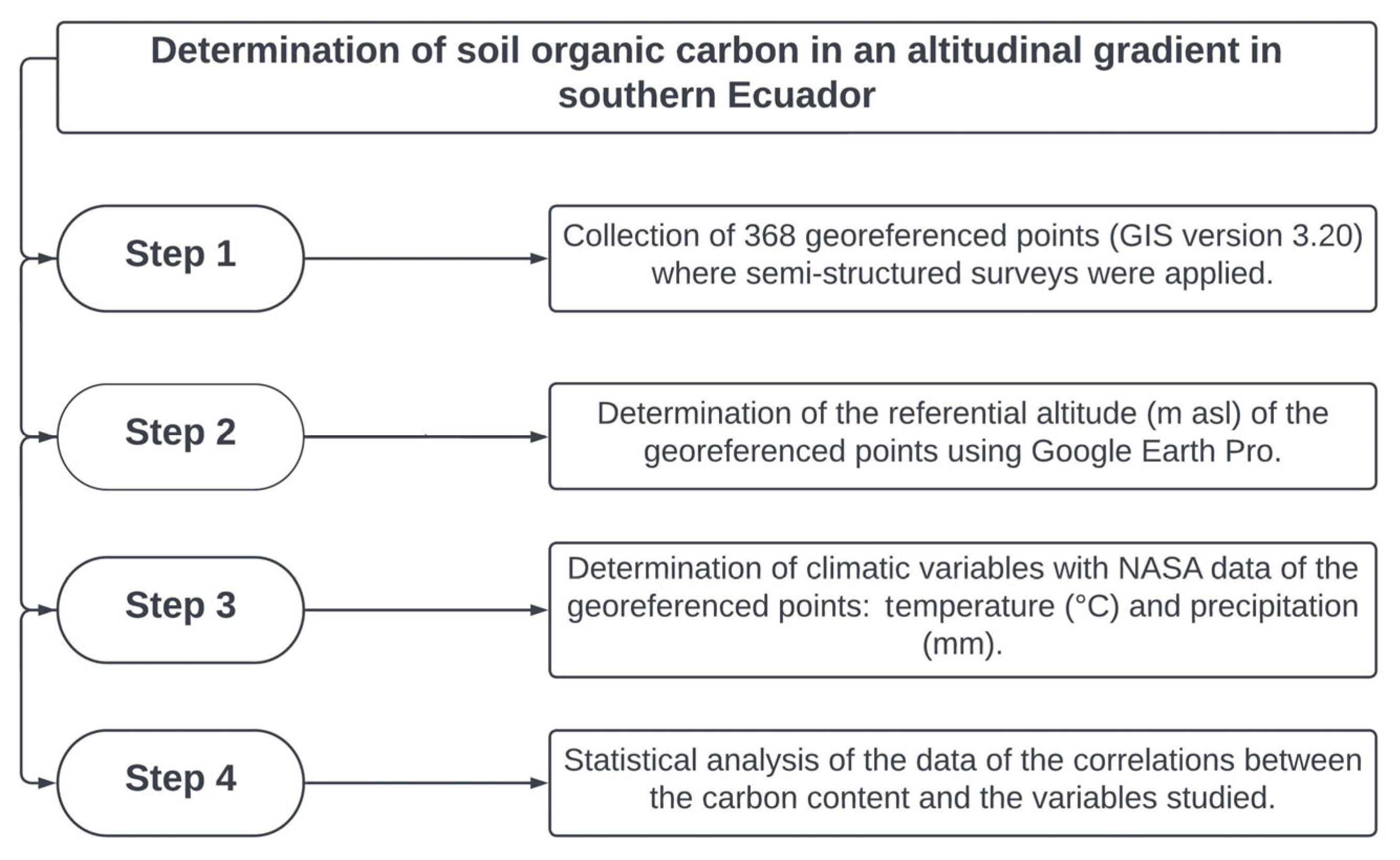
2. Materials and Methods
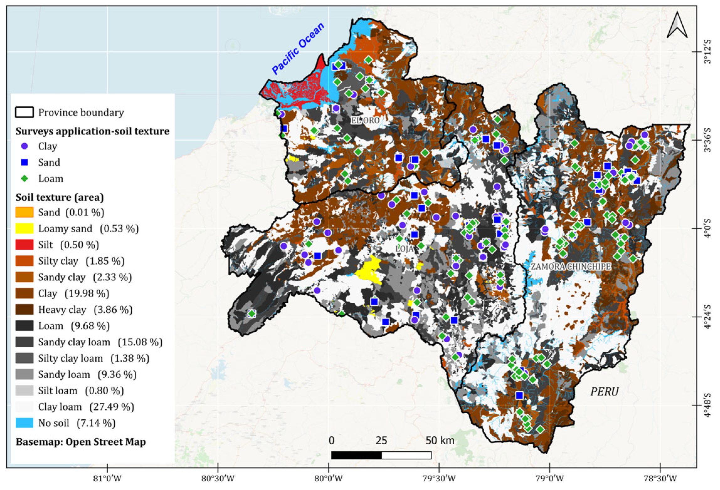
2.1. Study Area

The research was carried out in southern Ecuador in three provinces: Loja, El Oro, and Zamora Chinchipe. These provinces constitute the ‘Zone 7’, according to Ecuador’s administrative division for planning and public policy design (Figure 1).
The province of Loja is characterized by diverse topographic features, resulting in the most irregular relief in the country. This directly influences its ecosystem diversity, making it one of Ecuador’s most biologically complex and biodiverse provinces. The main natural vegetation types in Loja include montane evergreen forest, seasonally dry forest, shrubland, and páramo [27]. The altitude ranges from 115 to 3895 m above sea level (m a.s.l.). The annual temperature in Loja averages 16 °C, although it varies across different areas. In valleys such as Macará, Catamayo, and Zapotillo, temperatures exceed 22 °C, whereas in higher-altitude areas above 1500 m a.s.l., such as Saraguro, temperatures are around 10 °C [1]. Farmers in this province engage in diverse agricultural activities, cultivating a wide range of crops such as sugarcane (Saccharum officinarum), corn (Zea mays), beans (Phaseolus vulgaris), and legumes, as well as raising livestock for human consumption. The high agricultural diversity is largely attributed to the prevalence of clay loam soils with good drainage throughout the province [28].
The province of El Oro has an average temperature of 26.1 °C and an annual precipitation of 575.8 mm [29]. It is geographically influenced by dry and arid sections of the coastal region, as well as the humid, rainy areas originating from the western foothills of the Andes [1]. This geographical diversity results in three distinct climatic zones, classified as dry, tropical, and páramo climates [30]. The predominant soil orders in this province are Entisol, Inceptisol, and Alfisol [3]. The main economic activities include cattle breeding [31], as well as production and export of Musa spp. and Theobroma cacao L. [32] and shrimp farming [33].
Lastly, the province of Zamora Chinchipe has a megathermal climate, characterized by high humidity due to climatic variations and prolonged rainfall. The average annual temperature ranges from 21 °C to 25 °C, and the average annual precipitation ranges from 2100 mm to 2500 mm [34]. The predominant soil order is Inceptisol, followed by Entisol and Mollisol, which support the cultivation of sugarcane (Saccharum officinarum), banana (Musa paradisiaca), papaya (Carica papaya), and coffee (Coffea spp.) [34,35]. The main natural vegetation categories in Zamora Chinchipe include montane evergreen forest, premontane evergreen forests, shrubland, and páramo [28].
Figure 1. The study area of southern Ecuador (Zone 7), showing the provinces of Loja, El Oro, and Zamora Chinchipe. The different colors on the map represent the altitudinal ranges, and the dots indicate the places where the surveys were conducted. Map data from ©OpenStreetMap ODbL—Open Database License [36].
Sustainability 17 04983 g001

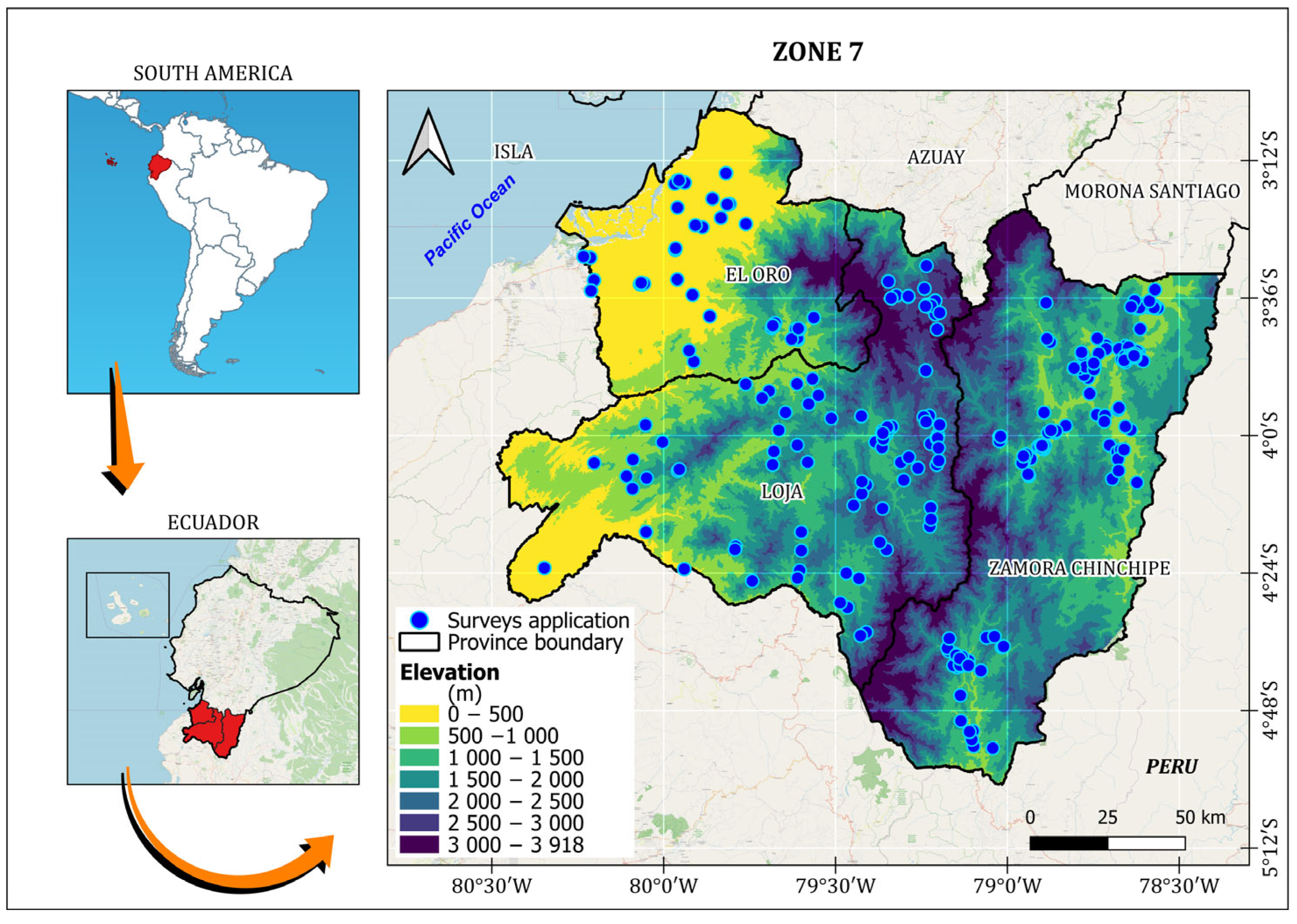
2.2. Data Collection

A total of 368 surveys were conducted with farmers in southern Ecuador (Figure 1). A total of 368 structured surveys were administered across the southern region of Ecuador, distributed as follows: 151 in Loja, 161 in Zamora Chinchipe, and 56 in El Oro. The sampling frame was based on the estimated agricultural population of the region, comprising approximately 180,791 producers and/or farming households [37]. The sample size was calculated to ensure a margin of error of ±7% with a confidence level of 93%, in accordance with the methodology proposed by [38].
The survey was administered verbally by the interviewer, who was responsible for explaining each question to the respondent and recording the answers in writing, according to the pre-established format. Before starting the process, the producer was informed of the purpose of the study and was asked for his or her consent to participate voluntarily. The producer was also assured that all information provided would be treated confidentially, respecting his privacy and ensuring the responsible use of the data collected.
The surveys contained 35 questions, which were designed following the methodology of [39,40]. Most of the questions were multiple-choice or dichotomous (i.e., with two response options such as ‘yes’ or ‘no’. Open-ended questions were included to explore farmers’ knowledge of soil fertility indicators—such as color, texture, or living organisms—as well as how soil management practices have evolved over time. For more details, see [24,25].
Determination of soil organic carbon content, textural, and climatic data
The determination of soil organic carbon content and textural classes was carried out in four main steps (Figure 2). Once the surveys were conducted, the geographic coordinates were recorded using QGIS software version 3.20-Odense. This process allowed for the extraction of data to quantify soil carbon stocks and identify textural classes at the canton level in each province under study, based on data from previous studies [41,42]. Subsequently, the altitude of each georeferenced point was determined [43], following the methodology described in [44]. Additionally, NASA meteorological data [45] were used to determine climate conditions along the altitudinal gradient, including temperature (°C) and precipitation (mm) [26,46].
These data were used to perform correlation and regression analysis to evaluate the effect of climate and SOC contents. In this context, altitudinal ranges were established every 500 m along each gradient.
To compare local knowledge with scientific knowledge, the percentages of the area corresponding to each of the 12 textural classes defined by the USDA, according to the map prepared, were calculated. These results were contrasted with the percentages of textural perception reported by the small farmers, who identified three main classes: loamy, sandy, and clayey.

2.3. Statistical Analysis

Microsoft Excel was used to organize and clean the data on local knowledge. Subsequently, a Chi-square test (p < 0.05) was performed to compare observed and expected frequencies of local knowledge variables. Additionally, to compare local knowledge with scientific knowledge, we analyzed georeferenced data from soil organic carbon stock surveys and soil textural class mapping conducted by [47]. This analysis was performed using the open-source software QGIS version 3.20-Odense [48], enabling the comparison of scientific data with local knowledge and perception.
Climatic variables (temperature and precipitation) were analyzed using a one-factor analysis of variance (ANOVA), followed by Tukey’s test for mean comparisons. Before applying parametric tests, the normality of the studied variables was assessed using the Shapiro–Wilk test. Additionally, Pearson correlations (p < 0.05) were performed to evaluate the relationship between the studied variables and soil organic carbon content. All statistical analyses of local knowledge and climatic data were conducted using SPSS software (v.24.0; SPSS Inc., Chicago, IL, USA).

3. Results

No significant relationship was found between interviewees’ gender and their province of residence. However, male respondents predominated in the surveyed group (Table 1). Statistically significant differences were found in responses related to age, ethnicity, educational level, and dedication to agriculture (Table 1). The youngest group of respondents was located in Zamora Chinchipe. In all provinces, most respondents identified as mestizo. Loja had the highest percentage of indigenous respondents, with 15% identified as indigenous. Most respondents in Loja had only primary education, those in El Oro had completed secondary education, and more than 40% of respondents in Zamora Chinchipe had a university education.
The perception of who is primarily responsible for farming varies across the study areas. In Loja and Zamora Chinchipe, farming is perceived as a family responsibility, whereas in El Oro, more than 70% of farming responsibilities fall on men (Table 1).

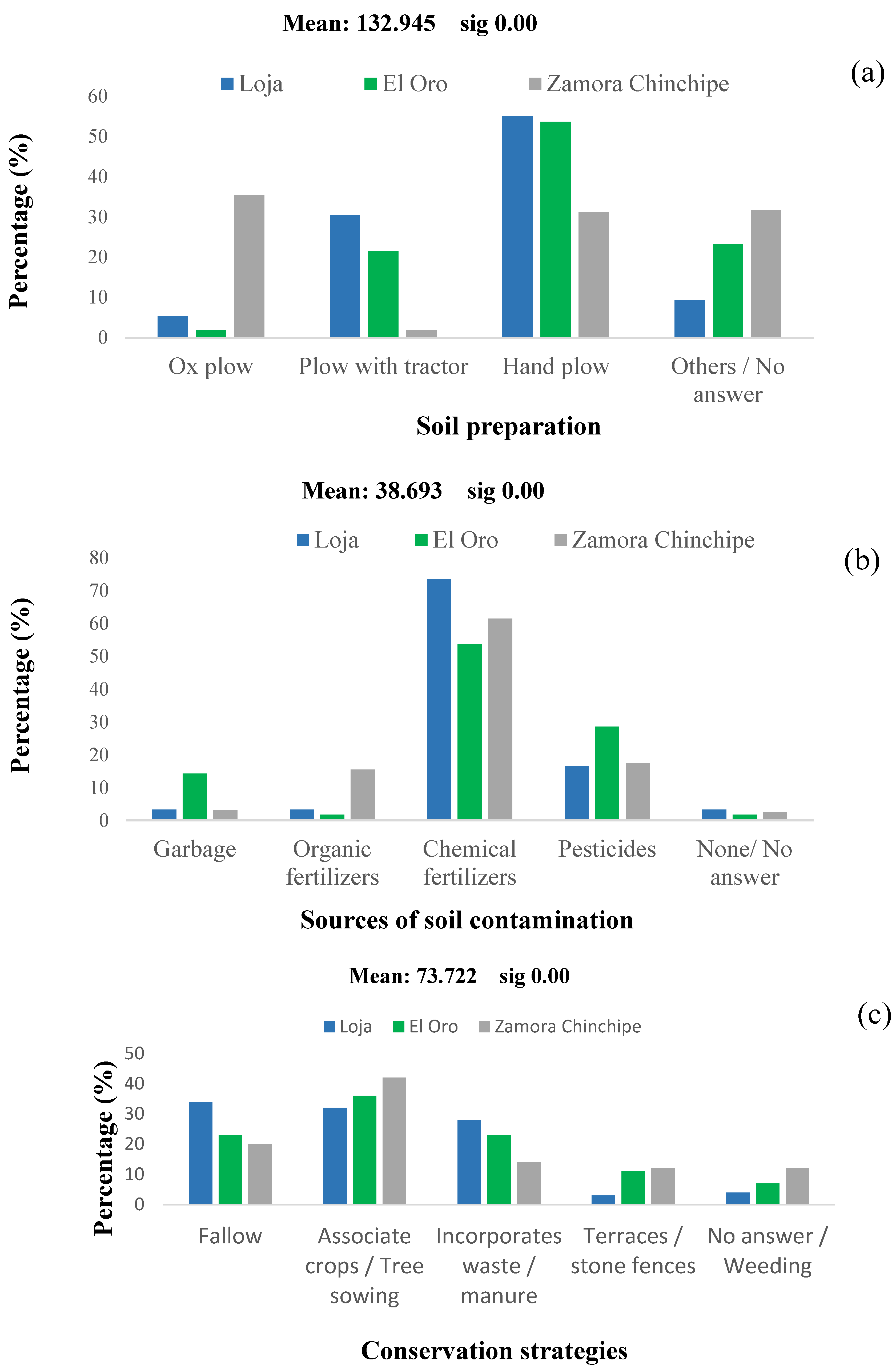
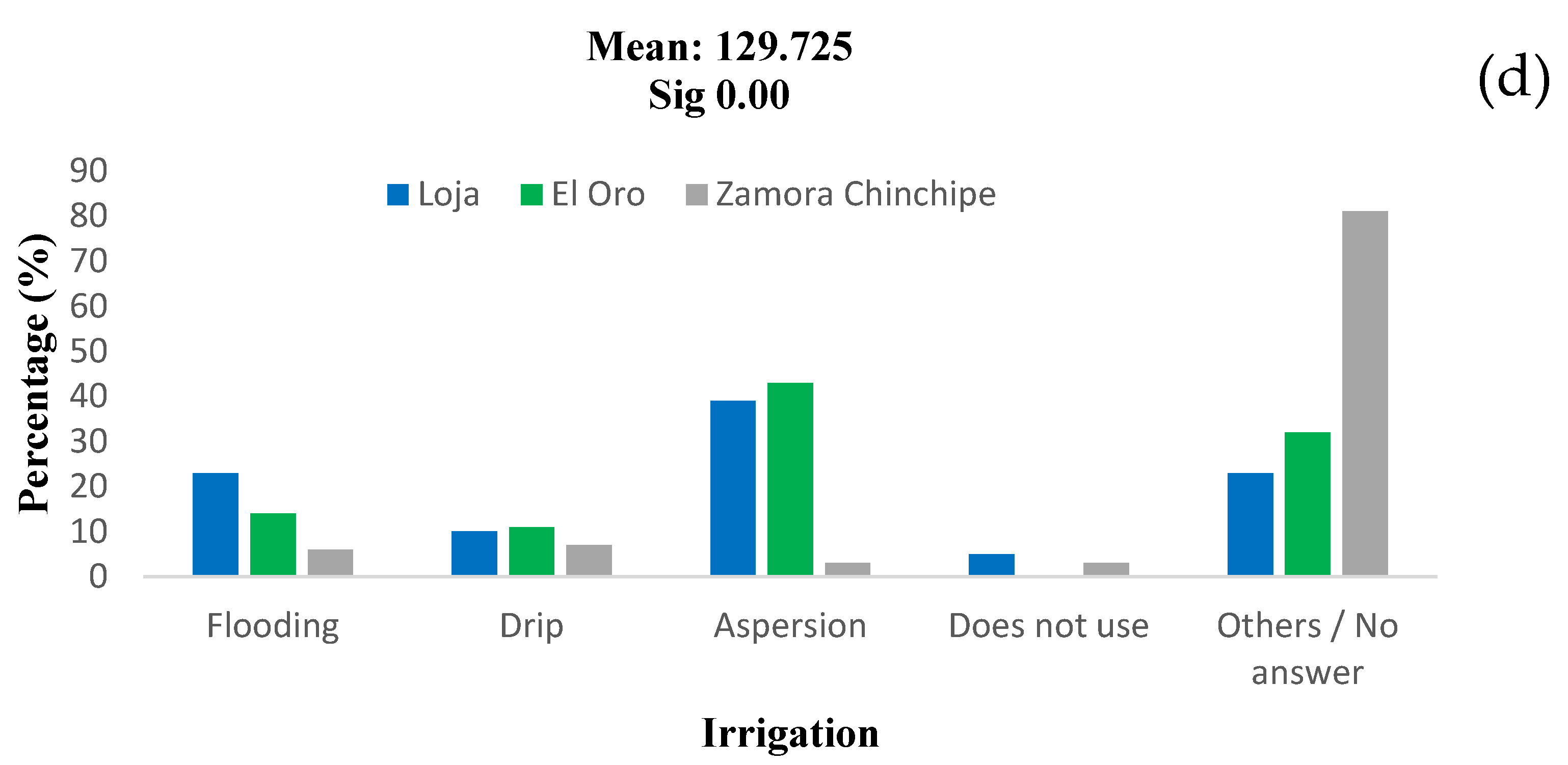
3.1. Traditional Knowledge in Soil Management

In the southern region of Ecuador, farmers prepare the soil manually, followed by plowing with oxen and tractors. However, in Zamora Chinchipe province, plowing with oxen is the predominant method, used by over 30% of farmers (Figure 3a).
Regarding sources of contamination, synthetic fertilizers were the most prevalent in the three provinces, followed by other agrochemicals, such as pesticides (Figure 3b).
Conservation strategies mainly involved crop association and tree planting, particularly in Zamora Chinchipe, followed by fallow practices and manure incorporation, both of which were more common in Loja (Figure 3c).
In El Oro and Loja, sprinkler irrigation was the predominant method for crop irrigation. In contrast, irrigation was not a common practice in Zamora Chinchipe, which could be related to the region’s geographical and climatic characteristics (Figure 3d). While flood or gravity irrigation was also used in El Oro, it was less prevalent than in Loja. Notably, drip irrigation was the least-used method across the three provinces.

3.2. Visible Indicators of Soil Fertility

According to farmers’ perceptions, soil color is an indicator of fertility and is statistically associated with the provinces (Table 2). Black soil predominates in Loja and Zamora Chinchipe, while brown soil is more common in El Oro.
Despite variations among the three provinces, consistent results were observed in several aspects. For example, both grasses and weeds were found to thrive in poor soils across all provinces surveyed, suggesting their ability to adapt to less-favorable conditions. Conversely, the results also highlighted that, according to the respondents’ perceptions, crops are those that thrive in fertile soils (Table 3).
Additionally, respondents mentioned certain species less frequently in fertile soils, such as Carica papaya in El Oro, Manihot esculenta mainly in the valleys of Loja, and Coffea arabica, which develops in various soil and climate conditions (Table 3). Aloe vera and Cortaderia sp. were reported at the three study sites, thriving in both fertile and poor soils.

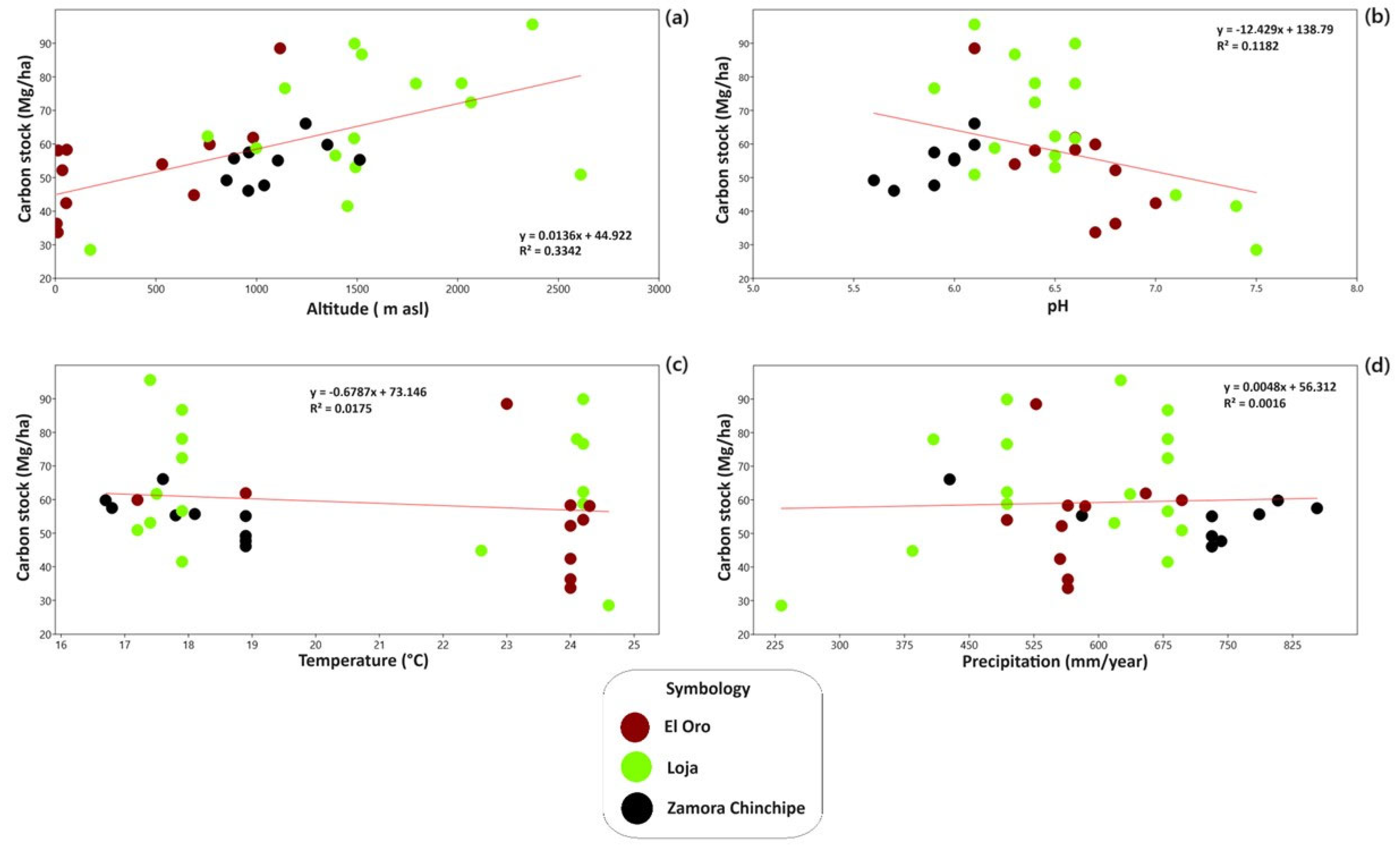
3.3. Soil Organic Carbon Stocks and Their Relationship with Environmental Factors

Details of the edaphoclimatic characteristics are presented in Table 4 for the locations studied along the altitudinal gradient.
Throughout the study area, the soil pH is slightly acidic (average pH = 6.4); however, Zamora Chinchipe exhibits more acidic soils (moderately acid soils, mean pH = 5.9) compared to Loja and El Oro (Table 4). At the canton level, some locations exhibit alkaline soils, such as Zapotillo (pH = 7.5) and Catamayo (pH = 7.4) in Loja province. On the other hand, the most acidic soils are found in Paquisha (pH = 5.6) and Nangaritza (pH = 5.7), both located in Zamora Chinchipe province.
Regarding soil carbon stocks, the lowest value (28.5 Mg/ha) was recorded in Zapotillo, the location with the lowest precipitation (232.3 mm yr−1) and the highest temperature (24.6 °C). Conversely, the highest carbon stock was found in Quilanga canton (95.6 Mg ha−1), a site located at the highest altitude (2371 m a.s.l.), with one of the lowest temperatures (17.4 °C) and precipitation above the study area average (>603.82 mm yr−1).
The correlation analysis reveals strong relationships among altitude, temperature, precipitation, soil carbon levels, and pH (Table 5, Figure 4). In general, as altitude increases, temperature decreases while precipitation increases, which corresponds to higher soil carbon stocks.
On the other hand, Table 5 presents the results obtained from the statistical analysis. Significant differences in SOC storage are observed at different altitudinal levels (HSD Tukey, p-value = 0.05; Table 5), and there is a clear positive correlation between altitude and carbon stocks.
The results indicate an increase in SOC stocks with altitude, ranging from 7 m a.s.l. to 2611 m a.s.l. This is described by the linear regression model (soil organic carbon (SOC) = 0.0136 + 44.922 × altitude; R2 = 0.3342) (Figure 4a) and a moderate positive correlation of 0.57806 (Table 6).

3.4. Integration of Local and Scientific Knowledge

There was consistency between local and scientific knowledge regarding soil textural classes. Most of the respondents reported having loamy soils, which aligns with the textural classes observed in Figure 5. The discrepancy between both types of knowledge is less than 10% (Figure 5, Table 7).
In the three provinces, clay loam soils predominate, followed by sandy clay loam and clay, which together account for more than 62.55% of the surface area (Figure 5). In Loja and Zamora Chinchipe, sandy loam soils also cover a significant area.
Consistency was also observed between carbon stocks and respondents’ perceptions of soil suitable for agriculture. However, this consistency was less evident than for textural classes, particularly when comparing carbon stocks with perceptions of soil color, where differences exceeded 10% in some cases (Table 8).
Across the three provinces, soils with intermediate to high carbon storage levels predominate, covering approximately 80% of the study area, with values ranging from 40 to 90 t ha−1. Additionally, about 14% of the study area has high carbon stocks (>90 t ha−1), especially in Loja (Figure 6). In contrast, around 7% of the study area exhibits low or very low carbon stocks (<40 t ha−1), particularly in Loja and El Oro.

4. Discussion

4.1. Traditional Knowledge in Soil Management

Traditional soil management practices are well established on small farms across many Latin American countries, including Ecuador [26]. Smallholder farmers rely on manual production methods due to land constraints and the high costs associated with the use of heavy machinery such as tractors. Although manual tillage requires more time and effort, it provides benefits for preserving ecosystem services and maintaining agricultural production [49]. However, its viability in large areas is limited by labor demands and economic costs. In the El Oro province study area (Coast), where extensive flatlands are primarily dedicated to banana cultivation [50], the use of machinery is common and necessary. In contrast, this study focuses on smaller-scale farms, where machinery use is less prevalent. In the provinces of Loja (Highlands) and Zamora Chinchipe (Amazon), steep slopes significantly limit the use of heavy machinery, making manual tillage the more practical option.
The practice of irrigation varies significantly along the altitudinal gradient. In Zamora Chinchipe, irrigation is rarely needed due to abundant rainfall, averaging approximately 2000 mm y−1 [1], which sufficiently meets crop water requirements. In contrast, regions such as Loja, characterized by lower rainfall and limited infrastructure for water collection and distribution, face a noticeable lack of adequate irrigation [51]. However, specific areas in Loja, such as Catamayo, Vilcabamba, and Malacatos, benefit from the Catamayo River, which is used to irrigate crops like sugarcane, citrus, and coffee [1].
El Oro, with its dense hydrographic network and several water concessions, enables the irrigation of major crops [52]. Nonetheless, small scale farmers in both El Oro and Loja face significant challenges due to water deficits, which hinder their ability to maintain crop growth and productivity without a reliable water supply.
In soil management practices related to tillage, farmers use inputs they perceive as potential soil contaminants, with chemical fertilizers being the primary input. This is largely due to the uncommon practice of performing soil analysis. For instance, at the national level, only 3.6% of lands smaller than 0.5 ha and dedicated to permanent crops undergo soil testing [53], a situation that is also common in the three study provinces.
The use of agrochemicals without appropriate technical assistance contributes to soil quality degradation, especially when applied excessively [54]. Farmers in all three study provinces have already observed soil degradation, particularly due to the indiscriminate use of fertilizers. For example, in the province of El Oro, significant amounts of nitrogen and potassium fertilizers are used in banana cultivation [55]. In Loja, urea is used to accelerate corn growth [56]. Meanwhile, in Zamora Chinchipe, although fertilizer use on pastures is uncommon, nitrogen, phosphorus, and potassium (NPK) fertilizers are applied in specific areas for cocoa cultivation [57]. Pesticides also represent a significant source of contamination, according to widespread farmer perceptions, particularly in El Oro, where their intensive use is a common practice.
This situation raises several environmental and public health concerns. The indiscriminate application of pesticides poses a significant risk to soil, water, and air quality, as well as to human health [58]. Moreover, the failure of farmers to collect and properly dispose of empty pesticide containers [59] exacerbates the contamination problem.
However, concern for soil conservation is a central issue in agricultural practices in the three study provinces. In response to this challenge, farmers have implemented various strategies, with tree planting and crop association being the most prominent, especially in Zamora Chinchipe and El Oro, according to local knowledge. In Zamora Chinchipe, the planting of trees such as Erythrina edulis L. Inga edulis, Psidium guajava L., Annona muricata L., and Caesalpinia spinosa (Molina) Kuntze, combined with pastures or coffee crops [60], as well as small plots of Theobroma cacao and mango [61], play a crucial role in stabilizing soil and increasing organic carbon levels. These practices not only enhance the resilience of local ecosystems but also promote plant and animal biodiversity.
Crop association represents another key strategy for soil conservation and increasing agricultural productivity [62]. In Loja, the adoption of polycultures and family gardens, where vegetables and fruit trees are grown, allows for better resources use and reduces pressure on the soil. This crop diversification not only improves soil health but also contributes to the sovereignty of local communities [63]. Another common practice in Loja, as well as in Zamora Chinchipe and El Oro, is following as an agricultural technique. By allowing the soil to rest for three to six years, this practice facilitates soil recovery and enhances its fertility [64].

4.2. Visible Indicators of Soil Fertility

Soil fertility indicators show a close relationship with readily observable soil properties. This was evident in the three study areas along the altitudinal gradient, where characteristics such as color, texture, depth, stoniness, and workability serve as reliable indicators of soil fertility [65,66]. Despite differences in climate, soil composition, and agricultural production across the three provinces [1], farmers identify similar parameters as indicators of soil fertility, with the exception of soil color. These indicators, like chemical or scientific ones, provide a comprehensive assessment of soil fertility and should be considered together.
Plants can also serve as excellent visual indicators for farmers, providing valuable insights into soil quality and conditions. The presence or absence of specific species offers information about nutrient availability, pH levels, the presence of contaminants, and even soil depth [67,68]. For instance, grasses and weeds often indicate infertile soils, while species such as Vachellia macracantha are indicative of both fertile and infertile soils. In contrast, crops and perennial species typically suggest deeper soils [23].

4.3. Soil Organic Carbon Stocks and Their Relationship with Environmental Factors

Studies conducted in Mediterranean forests in Spain [69] and shrublands in southern Ecuador have found a positive correlation between sampling altitude and SOC content. According to [70,71], this is attributed to pronounced variations along the altitudinal gradient, particularly temperature differences [70,71] and site-specific characteristics [72]. It has been observed that altitude significantly influences soil carbon stocks, given that higher altitudes tend to have lower temperatures, which reduce the rate of decomposition of organic matter and favor its accumulation. Furthermore, high-altitude ecosystems tend to have greater vegetation cover and less human disturbance, which also contribute to the increase in soil carbon storage [73]. These factors partly explain the variations observed at the different study sites.
Moreover, two additional factors that may influence SOC reserves are organic matter decomposition rates and soil respiration. Generally, lowland areas with higher temperatures exhibit increased primary production, greater organic matter accumulation, and faster decomposition rates, in contrast to forests at higher altitudes [26,74]. The results of this study suggest that altitude-driven climatic variation, along with site-specific environmental conditions, may partially explain the observed differences in SOC content in the study area. Although the focus of this work is limited to the analysis of the surface horizon (0–30 cm) and does not include morphological descriptions of profiles that would allow a complete taxonomic classification, recognizing the distribution of soil orders such as Entisols, Inceptisols, and Alfisols in the region is useful to contextualize the observed patterns. Future studies incorporating full profile descriptions could deepen the influence of soil orders on carbon dynamics, improving the understanding of edaphic processes in altitudinal gradients.

4.4. Integration of Local and Scientific Knowledge

Local and scientific knowledge constitute complementary and essential tools for assessing soil fertility, particularly in context where access to agricultural technologies is limited [75]. In this regard, recent studies conducted in southern Ecuador have shown that farmers are capable of visually identifying various soil parameters, such as texture, color, workability, and stoniness, as key indicators of soil productivity. These empirical observations, transmitted primarily from parents and grandparents, are supported by laboratory analyses that reveal positive correlations with these indicators [23]. Therefore, integrating local knowledge with scientific understanding enables a more holistic and context-sensitive assessment of soil fertility. For small-scale farmers, texture, color, depth, stoniness, and workability stand out as the primary indicators of soil quality [24]. This integration is particularly relevant in smallholder agricultural systems with limited resources, where even basic soil analysis remains uncommon, as is the case in the provinces of Loja and Zamora Chinchipe.
Integrating local and scientific knowledge not only benefits farmers but also supports trainers and related institutions [76]. This approach enables decision-making based on a more comprehensive information base by leveraging local knowledge rooted in each community and complementing it with scientific data. Such integration facilitates the adoption of more effective and sustainable agricultural practices, tailored to the specific conditions of each environment [63,77], while empowering farmers to become active participants in developing solutions. The authors of [78] noted the importance of farmers who are sole managers and decision makers in their operations for agricultural sustainability by developing sustainable solutions and implementing them through prioritizing and monitoring them in their operations [78].
These solutions represent important steps toward addressing short- and medium-term challenges. However, ensuring a sustainable and meaningful impact requires ongoing investigation of local alternatives. Such alternatives should be simple, easy to implement, and designed to encourage adoption by farmers. This approach not only addresses immediate needs but also enhances the capacity of local communities to face future challenges with context-specific solutions.

5. Conclusions

This study identified farmers’ knowledge of soil management in southern Ecuador. In general, their understanding aligns with scientific knowledge on key fertility indicators, such as color, texture, water infiltration, and moisture retention. However, discrepancies were found in the interpretation of soil color in Zamora Chinchipe, where the data only partially align with soil carbon stocks. It is recommended to promote training programs on sustainable soil conservation practices in the study area.
Farmers attribute their continued good harvests to soil management practices, which include manual tillage, application of organic fertilizers, and crop rotation. In addition, altitude directly influences soil carbon stocks, with higher rainfall and lower temperatures at greater elevations. These findings can support decision-makers in developing sustainable soil management policies that integrate both local and scientific knowledge.

Author Contributions

Conceptualization, L.J.; Methodology, V.C.-P., W.J., D.C.-M., P.Q. and N.F.; Validation, W.J. and L.J.; Formal analysis, V.C.-P., D.C.-M. and L.J.; Investigation, G.H., W.J. and N.F.; Writing—original draft, G.H., V.C.-P. and L.J.; Writing—review & editing, V.C.-P., W.J., D.C.-M., P.Q. and L.J.; Visualization, G.H.; Funding acquisition, L.J. All authors have read and agreed to the published version of the manuscript.

Funding

This study was supported by Universidad Técnica Particular de Loja. The funders had no role in study design, data collection and analysis, decision to publish, or preparation of the manuscript.

Institutional Review Board Statement

The justification was provided in a letter summarizing the following: In 2018, when the research was conducted, the Universidad Técnica Particular de Loja (UTPL) did not have Internal Regulations for the Ethics Committee in Research Involving Human Subjects (CEISH-UTPL). It was not until 2020 that the first Ethics and Disciplinary Regulations of the UTPL were approved, establishing standards of conduct, disciplinary procedures, and the creation of an Ethics Committee to guarantee due process in the event of very serious misconduct. These regulations were aligned with the principles of Christian humanism, respect for human rights, and national regulations. Subsequently, in 2022, the Ministry of Public Health issued Ministerial Agreement No. 00005-2022, which replaced the regulations for the approval and monitoring of CEISHs. Based on this regulation, in 2023, the UTPL developed its Internal Regulations for the Operation of the CEISH, which currently govern the review and monitoring of research involving human subjects. Since the study’s data collection spanned from 2018 to 2022, it was not mandatory to submit it for evaluation by a CEISH approved by the competent authority, as this regulation came into effect after that date. Therefore, it is not appropriate to issue an evaluation letter with a current date for a study initiated in 2018. The documents and regulations are available on the institutional website.

Informed Consent Statement

Informed consent was obtained from all individual participants included in the study.

Data Availability Statement

All relevant data are within the manuscript. If the editor, reviewer, or any researcher requires them, the data matrices will be provided.

Acknowledgments

We sincerely thank the farmers in the area for their valuable cooperation and willingness to participate in the surveys, which were fundamental to the development of this study. We also thank the OpenStreetMap platform and all its contributors for providing open geospatial data, which were essential for the creation of the maps used in this work.

Conflicts of Interest

The authors declare that they have no competing interests.

References

  1. Moreno, J.; Yerovi, F.; Herrera, M.; Yánez, D.; Espinosa, J. Soils from the highlands. In The Soils of Ecuador; Espinosa, J., Moreno, J., Bernal, G., Eds.; World Soils Book Series; Springer: Cham, Switzerland, 2018. [Google Scholar]
  2. Barros, A. Flora y Fauna Regional. Angew. Chem. Int. 2007, 6, 951–952. [Google Scholar]
  3. Villaseñor, D.; Chabla, J.; Luna, E. Caracterización física y clasificación taxonómica de algunos suelos dedicados a la actividad agrícola de la provincia de El Oro. Rev. Cient. 2015, 1, 25–34. [Google Scholar] [CrossRef]
  4. Acosta-Mireles, M.; Paz-Pellat, F.; Hidalgo-Moreno, C.; Etchevers-Barra, J.D. Patrones de distribución a profundidad del carbono orgánico del suelo en diferentes usos del suelo y manejo. Terra Latinoam. 2022, 40, 1–19. [Google Scholar] [CrossRef]
  5. Segura-Castruita, M.A.; Sánchez-Guzmán, P.; Ortiz-Solorio, C.A.; Gutiérrez-Castorena, M. Carbono orgánico de los suelos de México. Terra Latinoam. 2005, 23, 21–28. [Google Scholar]
  6. Loayza, N.V.; Sevilla, V.; Olivera, C.; Guevara, M.; Olmedo, G.; Vargas, R.; Oyonarte, C.; Jiménez, W. Mapeo digital de carbono orgánico en suelos de Ecuador. Ecosistemas 2020, 29, 1852. [Google Scholar] [CrossRef]
  7. Muñoz-Rojas, M.; Delgado-Baquerizo, M.; Lucas-Borja, M.E. La biodiversidad y el carbono orgánico del suelo son esenciales para revertir la desertificación. Ecosistemas 2021, 30, 2238. [Google Scholar] [CrossRef]
  8. Ruiz-García, P.; Monterroso-Rivas, A.I.; Valdés-Velarde, E.; Escamilla-Prado, E.; Gómez-Díaz, J.D. Carbon stocks in coffee (C. arabica L.) agroforestry systems in the face of climate change: México case. Agron. Mesoam. 2022, 33, 48671. [Google Scholar] [CrossRef]
  9. De Alba Alonso, S.; Alcázar Torralba, M.; Cermeño Martín, F.; Barbero Abolaño, F. Erosión y manejo del suelo. Importancia del laboreo ante los procesos erosivos naturales y antrópicos. In Agricultura Ecológica en Secano: Soluciones Sostenibles en Ambientes Mediterráneos; Ministerio De Agricultura, Alimentación y Medio Ambiente: Madrid, Spain, 2011; Volume 7, pp. 13–38. [Google Scholar]
  10. Beillouin, D.; Corbeels, M.; Demenois, J.; Berre, D.; Boyer, A.; Fallot, A.; Feder, F.; Cardinael, R. A global meta-analysis of soil organic carbon in the Anthropocene. Nat. Commun. 2023, 14, 3700. [Google Scholar] [CrossRef]
  11. Ramesh, T.; Bolan, N.S.; Kirkham, M.B.; Wijesekara, H.; Kanchikerimath, M.; Srinivasa Rao, C.; Sandeep, S.; Rinklebe, J.; Ok, Y.S.; Choudhury, B.U.; et al. Chapter One—Soil organic carbon dynamics: Impact of land use changes and management practices: A review. In Advances in Agronomy; Sparks, D.L., Ed.; Academic Press: Cambridge, MA, USA, 2019; pp. 1–107. [Google Scholar]
  12. Brechelt, A. Manejo ecológico del suelo. In Fundación Agricultura y Medio Ambiente; Red de Acción de Plaguicidas y Sus Alternativas Para América Latina: Santiago, Chile, 2004. [Google Scholar]
  13. Nezomba, H.; Mtambanengwe, F.; Tittonell, P.; Mapfumo, P. Practical assessment of soil degradation on smallholder farmers’ fields in Zimbabwe: Integrating local knowledge and scientific diagnostic indicators. Catena 2017, 156, 216–227. [Google Scholar] [CrossRef]
  14. Walteros-Torres, I.; Palacios-Pacheco, S.; Cely, G.E.; Serrano, P.A.; Moreno-Pérez, D. Influencia del cambio de uso del suelo sobre las reservas de carbono orgánico en el Parque Natural Regional Cortadera, Boyacá (Colombia). Rev. UDCA Actual. Divulg. Cient. 2022, 25, 1–9. [Google Scholar] [CrossRef]
  15. Vallejo, V.E. Importancia y utilidad de la evaluación de la calidad de suelos a través del componente microbiano: Experiencias en sistemas silvopastoriles. Colomb. For. 2013, 16, 83. [Google Scholar] [CrossRef]
  16. Barrera-Bassols, N.; Zinck, J.A. Ethnopedology: A worldwide view on the soil knowledge of local people. Geoderma 2003, 111, 171–195. [Google Scholar] [CrossRef]
  17. Pérez Magaña, A. Percepciones ambientales por productores agrícolas en una microrregión mexicana. Rev. Electrón. Medioambiente 2018, 19, 218–237. [Google Scholar]
  18. Fritz-Vietta, N.V.; Tahirindraza, H.S.; Stoll-Kleemann, S. Local people’s knowledge with regard to land use activities in southwest Madagascar–Conceptual insights for sustainable land management. J. Environ. Manag. 2017, 199, 126–138. [Google Scholar] [CrossRef] [PubMed]
  19. Jiménez, L.; Jiménez, W.; Ayala, N.; Quichimbo, P.; Fierro, N.; Capa-Mora, D. Exploring ethnopedology in the Ecuadorian Andean highlands: A local farmer perspective of soil indicators and management. Geoderma Reg. 2024, 36, e00755. [Google Scholar] [CrossRef]
  20. Ortiz, J.C. Clasificación local de suelos por agricultores ecológicos en el municipio de Buga, Colombia. Suelos Ecuat. 2018, 48, 16–22. [Google Scholar]
  21. Barrios, E. Agroforestería en planicies aluviales tropicales. Destreza indígena de Venezuela. In Agroforestería en las Américas; CATIE: Toronto, ON, Canada, 1995; p. 7. [Google Scholar]
  22. Hernández-Hernández, M.R.; Morros, M.E.; Bravo, C.; Lozano, Z.; Herrera, P.; Ojeda, A.; Morales, J.; Birbe, B. La integración del conocimiento local y científico en el manejo sostenible de suelos en agroecosistemas de sabanas. Interciencia 2011, 36, 104–112. [Google Scholar]
  23. Pauli, N.; Barrios, E.; Conacher, A.J.; Oberthür, T. Farmer knowledge of the relationships among soil macrofauna, soil quality and tree species in a smallholder agroforestry system of western Honduras. Geoderma 2012, 189, 186–198. [Google Scholar] [CrossRef]
  24. Jiménez, L.; Jiménez, W.; Felicito, D.; Fierro, N.; Quichimbo, P.; Sánchez, D.; Capa-Mora, D. Rediscovering the edaphic knowledge of smallholder farmers in southern Ecuador. Geoderma 2022, 406, 115468. [Google Scholar] [CrossRef]
  25. Jiménez, L.; Jiménez, W.; González, L.; Quichimbo, P.; Fierro, N.; Capa-Mora, D. Rescuing local knowledge with regards to soil management and fertility in the Amazon Region of Ecuador. Environ. Dev. 2024, 50, 100984. [Google Scholar] [CrossRef]
  26. Carrión-Paladines, V.; Benítez, Á.; García-Ruíz, R. Conversion of Andean montane forest to exotic forest plantation modifies soil physicochemical properties in the buffer zone of Ecuador’s Podocarpus National Park. For. Ecosyst. 2022, 9, 100076. [Google Scholar] [CrossRef]
  27. Tapia-Armijos, M.F.; Homeier, J.; Espinosa, C.I.; Leuschner, C.; De La Cruz, M. Deforestation and forest fragmentation in South Ecuador since the 1970s–losing a hotspot of biodiversity. PLoS ONE 2015, 10, e0133701. [Google Scholar] [CrossRef]
  28. Chamba, M.; Morocho-Durazno, L.; Vásquez, E. Tipificación de los sistemas productivos en el proyecto de riego Campana-Malacatos del cantón Loja, provincia de Loja. Bosques Latid. Cero 2018, 8, 96–108. [Google Scholar]
  29. Cañadas Cruz, L. Mapa Bioclimatico del Ecuador; Banco Central del Ecuador: Quito, Ecuador, 1983. [Google Scholar]
  30. Aguilar, E.; Reyes, K.; Ordoñez, O.; Calle, M. Uso y valoración de los recursos naturales y su incidencia en el desarrollo turístico: Caso Casacay, cantón Pasaje, El Oro-Ecuador. Rev. Interam. Ambiente Tur. 2018, 14, 80–88. [Google Scholar] [CrossRef]
  31. Vite, H.; Vargas, O. Ganadería de precisión en la provincia de El Oro. Diagnóstico situacional. Espirales Rev. Multidiscip. Investig. 2018, 2, 1–16. [Google Scholar]
  32. Zhiminaicela, J.B.; Quevedo, J.N.; García, R.M. La producción de banano en la Provincial de El Oro y su impacto en la agrobiodiversidad. Rev. Metrop. Cienc. Apl. 2020, 3, 189–195. [Google Scholar] [CrossRef]
  33. Varela-Velíz, H.; Elizalde, B.; Solórzano, S.; Varela-Velíz, G. Exportación de camarón de la provincia de El Oro en el contexto del Tratado Comercial con la Unión Europea. Espacios 2017, 38, 24. [Google Scholar]
  34. Romero, J.; Rivera, A. La hidrosiembra, técnica de bioingeniería para la restauración de suelos producto de actividades mineras: Experiencia en el proyecto minero mirador, Zamora Chinchipe-Ecuador. Rev. Medio Ambiente Min. 2020, 5, 11–21. [Google Scholar]
  35. Ministerio de Agricultura, Ganadería, Acuacultura y Pesca [MAGAP]. Cobertura y Uso de la Tierra, Sistemas Productivos. 2015. Available online: http://geoportal.agricultura.gob.ec/ (accessed on 5 March 2025).
  36. OpenStreetMap Contributors. OpenStreetMap [Mapa]. Available online: https://www.openstreetmap.org/#map=6/-1.78/-78.1337 (accessed on 10 March 2025).
  37. Ferreira Salazar, C.; García García, K.; Macías Leiva, L.; Pérez Avellaneda, A.; Tomsich, C. Mujeres y Hombres del Ecuador en Cifras III; Instituto Nacional de Estadística y Censos: Quito, Ecuador, 2014. [Google Scholar]
  38. Israel, G.D. Determining Sample Size. 1992, pp. 1–5. Available online: https://www.psycholosphere.com/Determining%20sample%20size%20by%20Glen%20Israel.pdf (accessed on 30 January 2024).
  39. Barrios, E.; Delve, R.J.; Bekunda, M.; Mowo, J.; Agunda, J.; Ramisch, J.; Trejo, M.T.; Thomas, R.J. Indicators of soil quality: A South–South development of a methodological guide for linking local and technical knowledge. Geoderma 2006, 135, 248–259. [Google Scholar] [CrossRef]
  40. Dawoe, E.K.; Quashie-Sam, J.; Isaac, M.; Oppong, S. Exploring farmers’ local Knowledge and perceptions of soil fertility and management in the Ashanti region of Ghana. Geoderma 2012, 179–180, 96–103. [Google Scholar] [CrossRef]
  41. Alianza Bioversity–CIAT; MAG. Mapa Digital de Fertilidad Química de los Suelos del Ecuador Continental. Potencial Hidrógeno (pH) del Suelo; Memoria Técnica; MAG: Quito, Ecuador, 2022. [Google Scholar]
  42. MAG; MAATE; FAO; GSP. Mapeo Digital de Carbono Orgánico en los Suelos del Ecuador, 2nd ed.; Memoria Técnica: Quito, Ecuador, 2021. [Google Scholar]
  43. Jarvis, A.; Reuter, H.I.; Nelson, A.; Guevara, E. Hole-Filled SRTM for the Globe, Version 4; the CGIAR-CSI SRTM 90m Database; CGIAR-CSI: Montpellier, France, 2008; Available online: https://srtm.csi.cgiar.org (accessed on 10 March 2025).
  44. Large, A.R.G.; Gilvear, D.J. Using Google Earth, a virtual-globe imaging platform, for ecosystem services-based river assessment. River Res. Appl. 2015, 31, 406–421. [Google Scholar] [CrossRef]
  45. National Aeronautics and Space Administration [NASA]. POWER Data Access Viewer. 2025. Available online: https://power.larc.nasa.gov/data-access-viewer (accessed on 15 March 2025).
  46. Solano, J.C.; Montaño, T.; Maldonado-Correa, J.; Ordóñez, A.; Pesantez, M. Correlation between the wind speed and the elevation to evaluate the wind potential in the southern region of Ecuador. Energy Rep. 2021, 7, 259–268. [Google Scholar] [CrossRef]
  47. QGIS. Sistema de Información Geográfica. 2021. Available online: http://www.qgis.org (accessed on 20 March 2025).
  48. Ministerio de Agricultura y Ganadería (MAG). Mapa Geopedológico del Ecuador Continental (Versión Editada por el Ministerio de Agricultura y Ganadería en 2019), Escala 1:25.000, Año 2009–2015; Ministerio de Agricultura y Ganadería: Quito, Ecuador, 2019. [Google Scholar]
  49. Dumanski, J.; Peiretti, R. Modern concepts of soil conservation. Int. Soil Water Conserv. Res. 2013, 1, 19–23. [Google Scholar] [CrossRef]
  50. Moreno, J.; Sevillano, G.; Valverde, O.; Loayza, V.; Haro, R.; Zambrano, J.; Reyes, D. Suelos de la Costa. In Suelos del Ecuador; Espinosa, J., Moreno, J., Bernal, G., Eds.; Instituto Geográfico Militar (IGM): Quito, Ecuador, 2022. [Google Scholar]
  51. Sosa, B.; Larrea, D. La tecnificación de la agricultura familiar bajo riego en Ecuador. In El Riego, Planificación y Tecnificación; CESA, CAMAREN: Quito, Ecuador, 2014; pp. 97–108. [Google Scholar]
  52. Conde, J.; Rivera, L. El riego en la provincia de El Oro. Ecuad. Calid. 2018, 5, 1–3. [Google Scholar]
  53. Instituto Nacional de Estadística y Censos (INEC). Módulo de Información Ambiental y Tecnificación Agropecuaria-ESPAC 2021; Instituto Nacional de Estadística y Censos: Quito, Ecuador, 2022. [Google Scholar]
  54. Singh, D.; Singh, S.K.; Modi, A.; Singh, P.K.; Yeka, V.; Kumar, A. Impacts of agrochemicals on soil microbiology and food quality. In Agrochemicals Detection, Treatment and Remediation; Butterworth-Heinemann: Oxford, UK, 2020; pp. 101–116. [Google Scholar]
  55. Valverde, E.; García, R.; Herrera, A.; Socorro, A. Alternativas nutricionales eficientes en banano orgánico en la provincia el Oro, Ecuador. Rev. Metrop. Cienc. Apl. 2019, 2, 152–159. [Google Scholar] [CrossRef]
  56. Remache, M.; Carrillo, M.; Mora, R.; Durango, W.; Morales, F. Macronutrient absorption and N uptake efficiency, in maize promising hybrid. Patricia Pilar, Ecuador. Agron. Costarric. 2017, 41, 103–115. [Google Scholar]
  57. Cuenca-Cuenca, E.W.; Puentes-Páramo, Y.J.; Menjivar-Flores, J.C. Efficient use of nutrients in fine aroma cacao in the province of Los Ríos-Ecuador. Rev. Fac. Nac. Agron. Medellín 2019, 72, 8963–8970. [Google Scholar] [CrossRef]
  58. Kopittke, P.M.; Menzies, N.W.; Wang, P.; McKenna, B.A.; Lombi, E. Soil and the intensification of agriculture for global food security. Environ. Int. 2019, 132, 105078. [Google Scholar] [CrossRef]
  59. Lithourgidis, C.S.; Stamatelatou, K.; Damalas, C.A. Farmers’ attitudes towards common farming practices in northern Greece: Implications for environmental pollution. Nutr. Cycl. Agroecosyst. 2016, 105, 103–116. [Google Scholar] [CrossRef]
  60. López-Beltrán, J.; Urgilés, N.; Aguirre Padilla, N. Productos forestales no maderables de origen vegetal en cinco comunidades de la parroquia Zumba, cantón Chinchipe, provincia de Zamora Chinchipe. Bosques Latid. Cero 2021, 11, 28–42. [Google Scholar]
  61. Mihai, R.A.; Melo, E.J.; Terán, V.A.; Espinoza, I.A.; Pinto, E.A.; Catana, R.D. The Panoramic View of Ecuadorian Soil Nutrients (Deficit/Toxicity) from Different Climatic Regions and Their Possible Influence on the Metabolism of Important Crops. Toxics 2023, 11, 123. [Google Scholar] [CrossRef] [PubMed]
  62. Bravo, C.; Benítez, D.; Vargas, J.; Alemán, R.; Torres, B.; Marín, H. Caracterización socio-ambiental de unidades de producción agropecuaria en la Región Amazónica Ecuatoriana: Caso Pastaza y Napo. Rev. Amaz. Cienc. Tecnol. 2015, 4, 3–31. [Google Scholar] [CrossRef]
  63. Harvey, C.A.; Komar, O.; Chazdon, R.; Ferguson, B.G.; Finegan, B.; Griffith, D.M.; Martínez-Ramos, M.; Morales, H.; Nigh, R.; Soto-Pinto, L.; et al. Integrating agricultural landscapes with biodiversity conservation in the Mesoamerican hotspot. Conserv. Biol. 2008, 22, 8–15. [Google Scholar] [CrossRef] [PubMed]
  64. Torres, B.; Jadán, O.; Aguirre, P.; Hinojosa, L.; Gunter, S. The Contribution of Traditional Agroforestry to Climate Change Adaptation in the Ecuadorian Amazon. The Chakra System. In Handbook of Climate Change Adaptation; Springer: Berlin/Heidelberg, Germany, 2015; pp. 1–2198. [Google Scholar]
  65. Abera, W.; Assen, M.; Satyal, P. Synergy between farmers’ knowledge of soil quality change and scientifically measured soil quality indicators in Wanka watershed, northwestern highlands of Ethiopia. Environ. Dev. Sustain. 2020, 23, 1316–1334. [Google Scholar] [CrossRef]
  66. Bajgai, Y.; Sangchyoswat, C. Farmers knowledge of soil fertility in West-Central Bhutan. Geoderma Reg. 2018, 14, e00188. [Google Scholar] [CrossRef]
  67. Cardoso, E.J.B.N.; Vasconcellos, R.L.F.; Bini, D.; Miyauchi, M.Y.H.; Santos, C.A.D.; Alves, P.R.L.; Nogueira, M.A. Soil health: Looking for suitable indicators. What should be considered to assess the effects of use and management on soil health? Sci. Agric. 2013, 70, 274–289. [Google Scholar] [CrossRef]
  68. Cheng, R.; Zhu, H.; Cheng, X.; Shutes, B.; Yan, B. Saline and Alkaline Tolerance of Wetland Plants—What are the Most Representative Evaluation Indicators? Sustainability 2020, 12, 1913. [Google Scholar] [CrossRef]
  69. Parras, L.; Lozano, B.; Galán, A. Soil organic carbon along an altitudinal gradient in the Despeñaperros Natural Park, southern Spain. Solid Earth 2015, 6, 125–134. [Google Scholar] [CrossRef]
  70. Solano, M.; Ramón, P.; Gusmán, M.E.; Burneo, J.I.; Quichimbo, P.; Jiménez, L. Efecto del gradiente altitudinal sobre las reservas de carbono y nitrógeno del suelo en un matorral seco en Ecuador. Ecosistemas 2018, 27, 116–122. [Google Scholar]
  71. Dieleman, W.I.; Venter, M.; Ramachandra, A.; Krockenberger, A.K.; Bird, M.I. Soil carbon stocks vary predictably with altitude in tropical forests: Implications for soil carbon storage. Geoderma 2013, 204, 59–67. [Google Scholar] [CrossRef]
  72. Quichimbo, P.; Jiménez, L.; Veintimilla, D.; Tischer, A.; Günter, S.; Mosandl, R.; Hamer, U. Forest Site Classification in the Southern Andean Region of Ecuador: A Case Study of Pine Plantations to Collect a Base of Soil Attributes. Forests 2017, 8, 473. [Google Scholar] [CrossRef]
  73. Baul, T.K.; Peuly, T.A.; Nandi, R.; Schmidt, L.H.; Karmakar, S. Carbon stocks of homestead forests have a mitigation potential to climate change in Bangladesh. Sci. Rep. 2021, 11, 9254. [Google Scholar] [CrossRef] [PubMed]
  74. Salinas, N.; Malhi, Y.; Meir, P.; Silman, M.; Roman, R.; Huaman, J.; Salinas, D.; Huaman, V.; Gibaja, A.; Mamani, M.; et al. The sensitivity of tropical leaf litter decomposition to temperature: Results from a large-scale leaf translocation experiment along an elevation gradient in Peruvian forests. New Phytol. 2011, 189, 967–977. [Google Scholar] [CrossRef] [PubMed]
  75. Delgado, J.A.; Groffman, P.M.; Nearing, M.A.; Goddard, T.; Reicosky, D.; Lal, R.; Kitchen, N.R.; Rice, C.W.; Towery, D.; Salon, P. Conservation practices to mitigate and adapt to climate change. J. Soil Water Conserv. 2011, 66, 118A–129A. [Google Scholar] [CrossRef]
  76. Luna, T.O.; Zhunusova, E.; Günter, S.; Dieter, M. Measuring forest and agricultural income in the Ecuadorian lowland rainforest frontiers: Do deforestation and conservation strategies matter? For. Policy Econ. 2020, 111, 102034. [Google Scholar] [CrossRef]
  77. Chacón, G.; Gagnon, D.; Paré, D. Soil agricultural potential in four common Andean land use types in the Highlands of Southern Ecuador as revealed by a corn bioassay. Agric. Sci. 2015, 6, 1129. [Google Scholar] [CrossRef]
  78. Manono, B.O. New Zealand dairy farm effluent, irrigation and soil biota management for sustainability: Farmer priorities and monitoring. Cogent Food Agric. 2016, 2, 1221636. [Google Scholar] [CrossRef]
Figure 2. Schematic flow of the methodology used for the determination of soil organic carbon and textural classes along an altitudinal gradient. The different data flows and analytical steps for the four stages of this study are shown, as well as how these steps are interrelated.
Sustainability 17 04983 g002
Figure 3. Traditional knowledge in soil management in southern Ecuador: (a) comparison of the three forms of tillage prior to planting; (b) farmers’ perception of the main sources of soil contamination; (c) main practices for maintaining healthy soil on respondents’ farms; (d) types of irrigation.
Sustainability 17 04983 g003aSustainability 17 04983 g003b
Figure 4. Relationship between soil organic carbon and the variables elevation, pH, temperature, and precipitation. (a) Relationship with altitude; (b) relationship with pH; (c) relationship with temperature; (d) relationship with precipitation in the altitudinal gradient of southern Ecuador. The red, green, and black dots correspond to the cantons of each province studied. Furthermore, SOC stocks are associated with decreasing soil pH along the altitudinal gradient, as described by a linear regression model (b); SOC = −12.429 + 138.79 × pH; R2 = 0.1182; p < 0.0001) and a moderate negative correlation (r = −0.34383) (Table 5). Since most soils along the altitudinal gradient are acidic, this correlation suggests that lower pH values (i.e., increase acidity) are linked to higher SOC stocks. This negative relationship may reflect the influence of soil acidity on microbial activity and organic matter decomposition.
Sustainability 17 04983 g004
Figure 5. Map of the farmers’ perceptions of soil texture in the provinces of Loja, El Oro, and Zamora Chinchipe, compared to surface soil texture from the Geopedological map of Ecuador [48]. Map data from ©OpenStreetMap ODbL—Open Database License [36].
Sustainability 17 04983 g005
Figure 6. Map of farmers’ perceptions of soil color compared to carbon stock percentages in the study area (Loja, El Oro and Zamora Chinchipe). Map data from ©OpenStreetMap ODbL—Open Database License [36].
Sustainability 17 04983 g006
Table 1. General characteristics of respondents in the provinces of the study area of southern Ecuador, analyzed using the Chi-square test.
LojaEl OroZamora ChinchipeTotalX-ValueSig (p < 0.05)
%%%%
Age17–3521.8516.0744.7230.9737.360.00
SD
36–5540.4046.4232.2337.77
55–7024.5028.5715.5221.19
>7011.261.783.726.52
No response1.997.143.723.5
EthnicityMestizo81.4694.6486.3385.5949.590.00
SD
Indigenous15.230.002.487.33
Caucasian0.001.7811.185.16
Afro-Ecuadorian2.653.570.001.63
No response0.660.000.000.27
Education levelPrimary43.0525.0012.4226.9076.430.00
SD
High school30.4648.2136.0235.60
Superior10.6026.7941.6126.63
None13.910.004.987.88
Others1.980.004.972.99
Who dedicates more time to agriculture or livestock?Men44.3773.2126.7141.0385.730.00
SD
Women9.933.576.217.34
All family45.0323.2240.9939.95
Others/No answer0.670.0026.0911.68
Statistical notation: SD = significant difference.
Table 2. Analysis of the main soil fertility indicators according to surveys applied in the study area.
LojaEl OroZamora ChinchipeTotalX-ValueSig (p < 0.05)
%%%%
It is that soils are coloredBlack49.6719.6465.8452.1749.600.00
SD
Brown34.4466.0720.5033.15
Reddish3.973.575.594.62
Yellow7.2810.715.597.07
White0.660.000.000.27
Others0.660.000.620.54
Note: SD indicates significant differences between provinces because of the application of the Chi-square test (p < 0.05).
Table 3. Plant species present in fertile and infertile soils, as perceived by farmers in southern Ecuador.
Study PlacesPlants in Infertile SoilsSpeciesPlants in Fertile SoilsSpecies
LojaPasturesPaspalum candidum (Flüggé) Kunth., Cynodon dactylon (L.) Pers., Pennisetum clandestinum Hochst. ex Chiov,
Pennisetum purpureum Schumach.
VegetablesNot specified
LlashipaPteridium aquilinum (L.) KuhnCornZea mays L.
FaiqueVachellia macracantha (Humb. and Bonpl. ex Willd.) Seigler and EbingerMedicinal plantsNot specified
Shiran/amor seco/huichingueBidens pilosa L.YuccaManihot esculenta
ChilcaBaccharis obtusifolia KunthCoffeeCoffea arabica
El OroPasturesCynodon dactylonMedicinal plantsAloysia citrodora, Chamaemelum nobile, Mentha piperita,
Origanum vulgare,
Melissa officinalis,
Verbena officinalis,
Plantago major,
Vaccinium meridionale
Banana and plantainMusa L.MangoMangifera indica
WeedsNot specifiedCocoaTheobroma cacao
CitrusCitrus limon,
Citrus reticulata,
Citrus sinensis,
Citrus aurantium,
Citrus aurantiifolia
Zamora ChinchipeShrubsVernonanthura patensVegetablesLactuca sativa,
Brassica oleracea var. capitata,
Coriandrum sativum
MossBryopteris filicinaMedicinal plantsMenta piperita,
Ruta graveolens, Chamaemelum nobile
WeedsEchinochloa colona; Trifolium repensCitrusCitrus sinensis,
Citrus reticulata,
Citrus limon
PasturesCynodon dactylon, pennisetum merkeri, brachiaria decumbensGuabaInga edulis
FernsPteridium aquilinumGuayabaPsidium guajava
Table 4. Edaphoclimatic characteristics of the studied sites in the altitudinal gradient in southern Ecuador.
Study PlacesGeoreferenced PointsAltitude (Average m a.s.l.)Temp. °C (Average/Year)Pp (Average mm/Year)Carbon Stock (Mg/ha)pH
El OroMachala7724564.436.36.8
Huaquillas21224564.433.76.7
El Guabo31424.3584.558.16.4
Pasaje103524.0557.352.26.8
Arenillas75424.0555.442.47.0
Santa Rosa85724564.458.36.6
Marcabelí253124.2493.854.06.3
Piñas898318.9654.761.96.6
Portovelo376717.2696.659.96.7
Zaruma6111723527.688.56.1
LojaZapotillo517424.6232.328.57.5
Macará468922.6384.344.87.1
Chaguarpamba599924.2493.858.86.2
Pindal4756.824.2493.962.36.5
Puyango3114124.2493.876.65.9
Catamayo31145217.9680.141.57.4
Paltas5139217.9680.256.66.5
Calvas5148517.5636.661.76.6
Celica5148724.2493.889.96.6
Espíndola5149217.4618.353.16.5
Olmedo5152317.9680.286.76.3
Sozoranga5179224.1408.678.06.6
Saraguro30261117.2696.650.96.1
Loja28201917.9680.278.16.4
Gonzanamá6206617.9680.272.46.4
Quilanga5237117.4625.795.66.1
Zamora ChinchipePaquisha385118.9731.449.25.6
Yantzaza5988818.1786.355.76.0
Nangaritza1095918.9731.446.15.7
El Pangui1596216.8853.257.55.9
Zamora33103818.9742.247.75.9
C. del Cóndor6110618.9731.455.16.0
Chinchipe7124417.6427.466.16.1
Yacuambi3135216.7807.959.86.1
Palanda25151317.8580.855.36.0
Note: The abbreviation Pp stands for precipitation.
Table 5. Pearson correlation analysis between climatic variables, pH, and soil carbon stocks in the study area.
Altitude (Average m a.s.l.)Temperature °C (Average/Year)Precipitation (Average mm/Year)Carbon Stock (Mg/ha)pH
Altitude (Average m a.s.l.)1
Temp, °C (average/year)−0.629821
Pp (Average mm/year)0.28583−0.719111
Carbon stock (Mg/ha)0.57806−0.132310.0398091
pH−0.33190.37478−0.51917−0.343831
Table 6. Climatic conditions and soil organic carbon (SOC) stocks across the elevation ranges of the altitudinal gradient in the study area (average values with standard deviation).
Elevation Range (m a.s.l.)Temp. °C
(Year)
Precipitation (mm year−1)Carbon Stocks (Mg/ha)
0–50024.1 ± 0.2 a517.5 ± 126.0 a44.2 ± 12.1 a
501–100020.4 ± 3.0 ab631.9 ± 155.0 a55.0 ± 6.4 ab
1001–150019.5 ± 2.9 b621.8 ± 121.0 a63.3 ± 15.7 ab
1501–200019.9 ± 3.6 ab556.5 ± 137.0 a73.3 ± 16.2 b
2001–250017.6 ± 0.4 b670.7 ± 31.0 a74.3 ± 18.4 b
Different lowercase letters show significant statistical difference (p < 0.05) between the different altitudinal floors (temperature, precipitation and carbon stock variables).
Table 7. Percentages of farmers’ perception of soil texture in the provinces of Loja, El Oro, and Zamora Chinchipe in contrast to the percentages of surface soil texture according to the Geopedological map of Ecuador [37].
Scientific Knowledge (USDA)Local Knowledge
Textural ClassPercentage (%)Textural ClassPercentage (%)
Sand9.9Sandy13.85
Loamy sand
Sandy loam
Loam54.93Loamy (intermediate or balanced)64.13
Silt loam
Clay loam
Silty clay loam
Sandy clay loam
Silt
Clay28.02Clayey20.92
Sandy clay
Silty clay
No soil7.14Did not respond1.08
Table 8. Percentages of farmers’ perceptions of soil fertility and color compared to surface carbon stocks in the study area (Loja, El Oro, and Zamora Chinchipe).
Local KnowledgeScientific KnowledgeLocal Knowledge
How Do You Consider the Soils on Your Farm?Percentage (%)Carbon Stocks (t ha−1)Percentage (%)ColorPercentage (%)
Very good29.08High40.67Black52.17
Suitable61.96Middle52.48Brown33.15
Poor6.79Low6.85Red
Yellow
White
11.96
Did not respond2.17 Did not respond2.72
Disclaimer/Publisher’s Note: The statements, opinions and data contained in all publications are solely those of the individual author(s) and contributor(s) and not of MDPI and/or the editor(s). MDPI and/or the editor(s) disclaim responsibility for any injury to people or property resulting from any ideas, methods, instructions or products referred to in the content.

