
Geosystem Properties and Services in Global South Cities: Examples of São Paulo and Johannesburg


Abstract
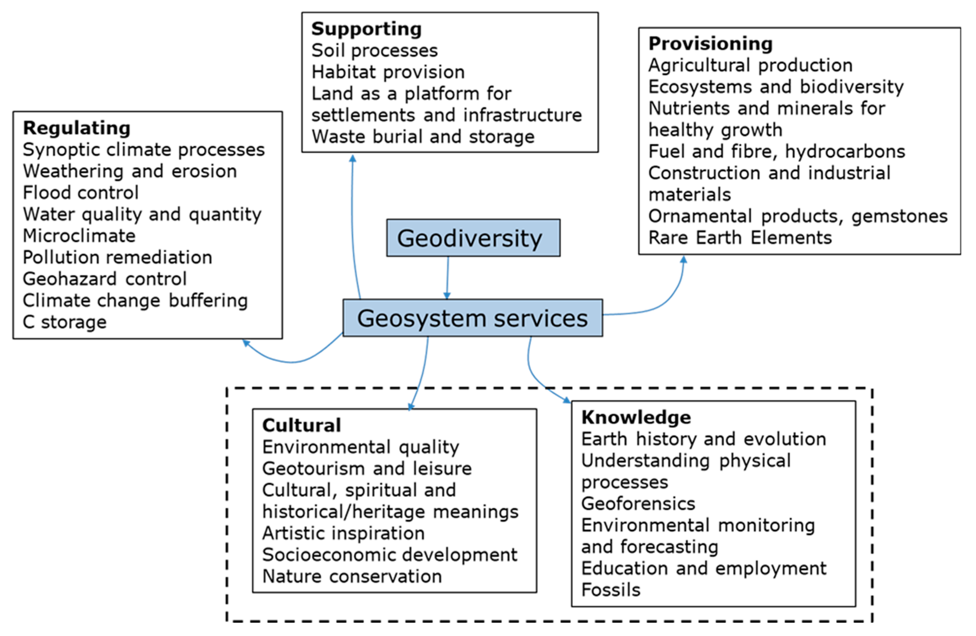
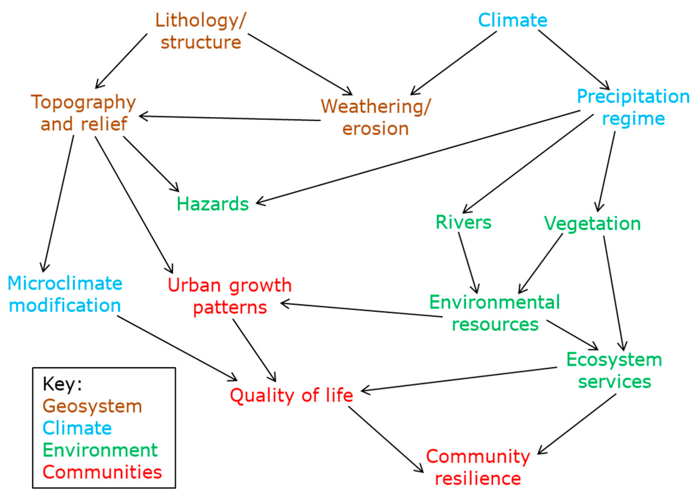
1. Introduction
2. Methodological Approach
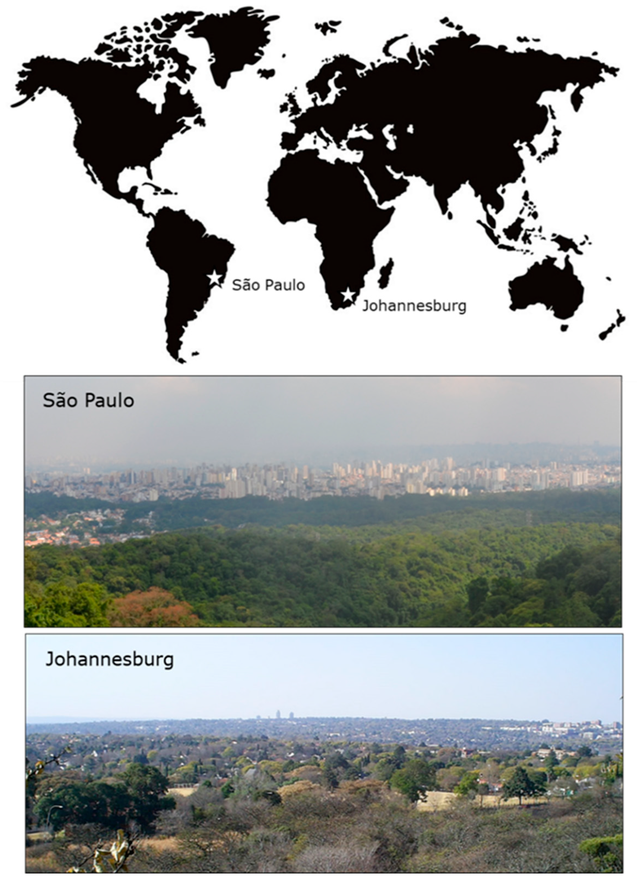
3. Results: Characteristics of the Study Sites
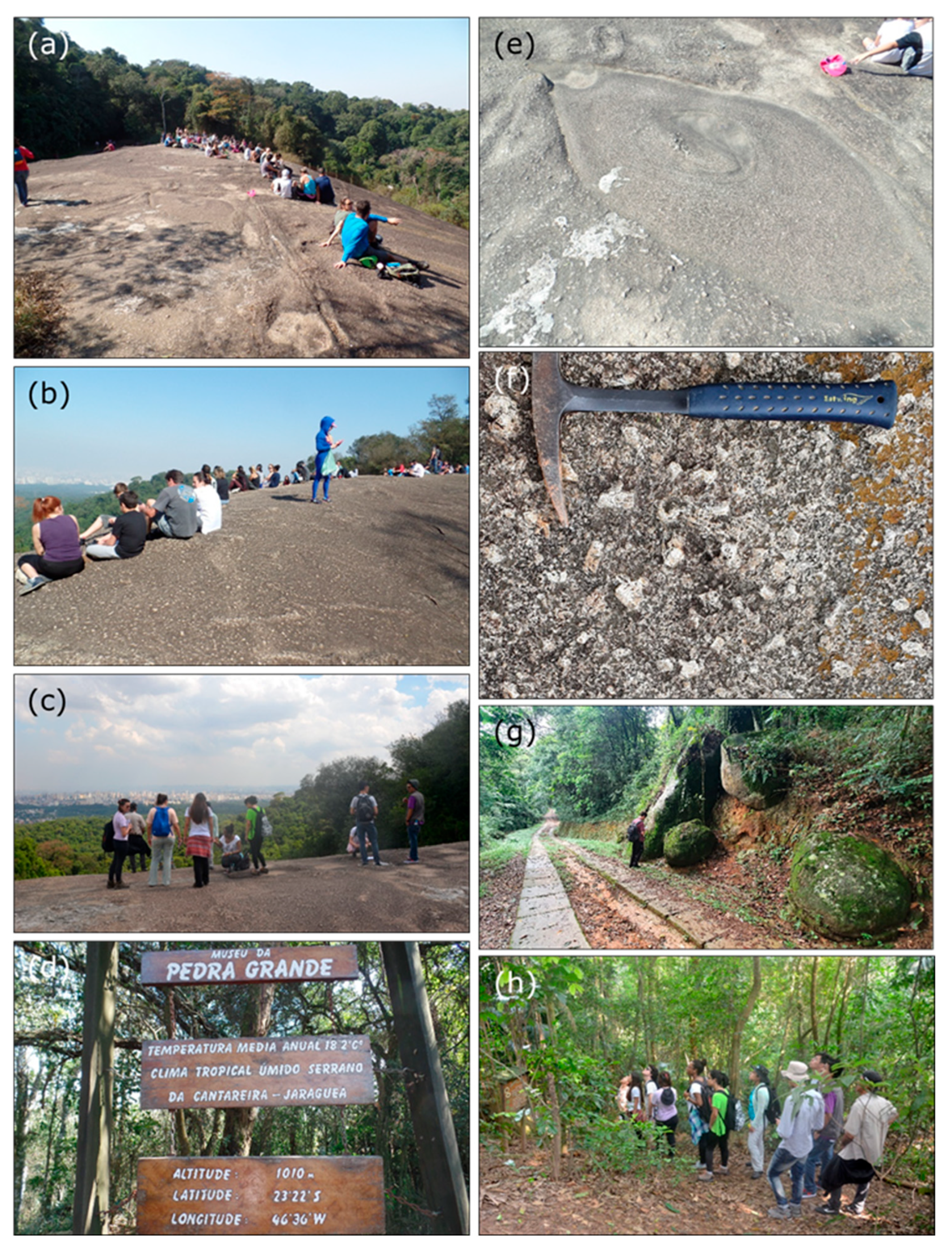
3.1. Cantareira State Park (São Paulo)
3.1.1. Background and Geology
3.1.2. Ecosystems and Species
3.1.3. Human Activity, Management, and Conservation Issues
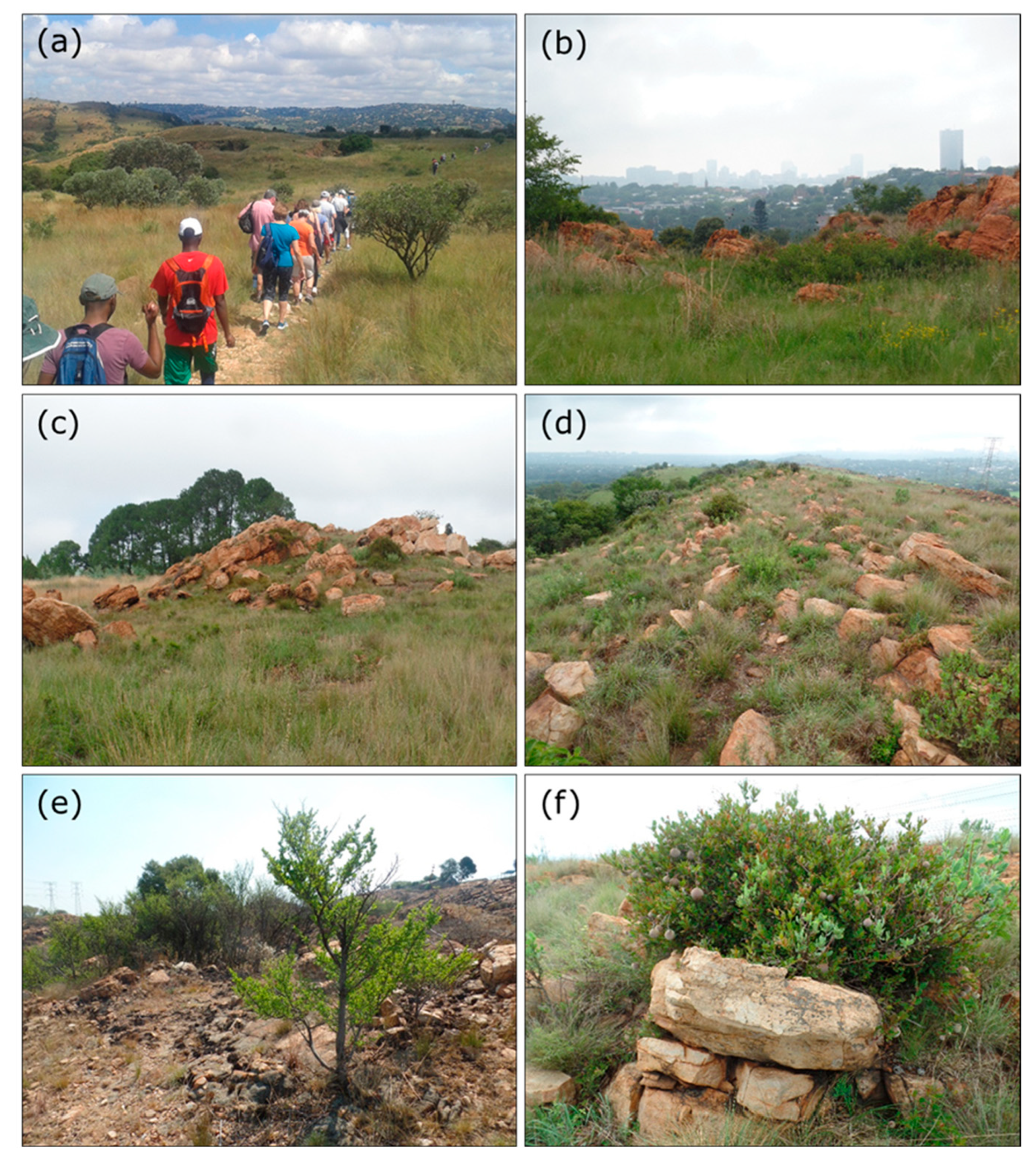
3.2. Melville Koppies (Johannesburg)
3.2.1. Background and Geology
3.2.2. Ecosystems and Species
3.2.3. Human Activity, Management, and Conservation Issues
3.3. Comparison Between the Geosystem Services at the Two Sites
4. Discussion
4.1. Critique of Inventories of Geosystem Services
4.2. Exploiting Geosystem Services in the Pursuit of Sustainable Development
4.3. Research Limitations and Future Research Directions
5. Conclusions
Author Contributions
Funding
Institutional Review Board Statement
Informed Consent Statement
Data Availability Statement
Conflicts of Interest
References
- Burlando, M.; Firpo, M.; Queirolo, C.; Rovere, A.; Vacchi, M. From Geoheritage to Sustainable Development: Strategies and Perspectives in the Beigua Geopark (Italy). Geoheritage 2011, 3, 63–72. [Google Scholar] [CrossRef]
- Gray, M.; Gordon, J.E.; Brown, E.J. Geodiversity and the ecosystem approach: The contribution of geoscience in delivering integrated environmental management. Proc. Geol. Assoc. 2013, 124, 659–673. [Google Scholar] [CrossRef]
- Alahuhta, J.; Ala-Hulkko, T.; Tukiainen, H.; Purola, L.; Akujärvi, A.; Lampinen, R.; Hjort, J. The role of geodiversity in providing ecosystem services as broad scales. Ecol. Indic. 2018, 91, 47–56. [Google Scholar] [CrossRef]
- Gray, M. The confused position of the geosciences within the “natural capital” and “ecosystem services” approaches. Ecosyst. Serv. 2018, 34, 106–112. [Google Scholar] [CrossRef]
- Fox, N.; Graham, L.J.; Eigenbrod, F.; Bullock, J.M.; Parks, K.E. Incorporating geodiversity in ecosystem service decisions. Ecosyst. People 2020, 16, 151–159. [Google Scholar] [CrossRef]
- Knight. J. Environmental services: A new approach towards addressing Sustainable Development Goals in sub-Saharan Africa. Front. Sustain. Food Syst. 2021, 5, 687863. [Google Scholar]
- Khoso, R.B.; Negri, A.; Guerini, M.; Mantovani, A.; Shajahan, R.; Gentilini, S.; Perotti, L.; Giardino, M. The virtuous circle of geodiversity: Application of geoscience knowledge for sustainability in the framework of the International Geodiversity Day. Quaest. Geogr. 2024, 43, 95–120. [Google Scholar] [CrossRef]
- van Ree, D.; van Beukering, P.J.H.; Hofkes, M.W. Linking geodiversity and geosystem services to human well-being for the sustainable utilization of the subsurface and the urban environment. Phil. Trans. R. Soc. Ser. A 2024, 382, 20230051. [Google Scholar] [CrossRef]
- Oosterveer, P. Urban environmental services and the state in East Africa; between neo-developmental and network governance approaches. Geoforum 2009, 40, 1061–1068. [Google Scholar] [CrossRef]
- Caro-Borrero, A.; Corbera, E.; Neitzel, K.C.; Almeida-Leñero, L. “We are the city lungs”: Payments for ecosystem services in the outskirts of Mexico City. Land Use Pol. 2015, 43, 138–148. [Google Scholar] [CrossRef]
- Marques, G.F.; de Souza, V.B.F.S.; Moraes, N.V. The economic value of the flow regulation environmental service in a Brazilian urban watershed. J. Hydrol. 2017, 554, 405–419. [Google Scholar] [CrossRef]
- Grimmond, S.; Boucher, V.; Molina, L.T.; Baklanov, A.; Tan, J.; Schlünzen, K.H.; Mills, G.; Golding, B.; Masson, V.; Ren, C.; et al. Integrated urban hydrometeorological, climate and environmental services: Concept, methodology and key messages. Urban Clim. 2020, 33, 100623. [Google Scholar] [CrossRef] [PubMed]
- Bobylev, N.; Syrbe, R.-U.; Wende, W. Geosystem services in urban planning. Sustain. Cities Soc. 2022, 85, 104041. [Google Scholar] [CrossRef]
- Stavi, I.; Rachmilevitch, S.; Yizhaq, H. Small-scale geodiversity regulates functioning, connectivity, and productivity of shrubby, semi-arid rangelands. Land Degrad. Develop. 2018, 29, 205–209. [Google Scholar] [CrossRef]
- Garcia, M.G. Ecosystem services provided by geodiversity: Preliminary assessment and perspectives for the sustainable use of natural resources in the coastal region of the state of São Paulo, Southeastern Brazil. Geoheritage 2019, 11, 1257–1266. [Google Scholar] [CrossRef]
- Kubalíková, L. Cultural ecosystem services of geodiversity: A case study from Stránská skála (Brno, Czech Republic). Land 2020, 9, 105. [Google Scholar] [CrossRef]
- Silva, M.L.N.; Nascimento, M.A.L. Ecosystem services and typology of urban geodiversity: Qualitative assessment in Natal Town, Brazilian Northeast. Geoheritage 2020, 12, 57. [Google Scholar] [CrossRef]
- Crisp, J.R.A.; Ellison, J.C.; Fischer, A.; Tan, J.A.D. Geodiversity inclusiveness in biodiversity assessment. Progr. Phys. Geogr. 2023, 47, 414–437. [Google Scholar] [CrossRef]
- Gordon, J.E.; Barron, H.F. Valuing geodiversity and geoconservation: Developing a more strategic ecosystem approach. Scot. Geogr. J. 2012, 128, 278–297. [Google Scholar] [CrossRef]
- Chakraborty, A.; Cooper, M.; Chakraborty, S. Geosystems as a Framework for Geoconservation: The Case of Japan’s Izu Peninsula Geopark. Geoheritage 2015, 7, 351–363. [Google Scholar] [CrossRef]
- Hjort, J.; Gordon, J.E.; Gray, M.; Hunter Jr, M.L. Why geodiversity matters in valuing nature’s stage. Conserv. Biol. 2015, 29, 630–639. [Google Scholar] [CrossRef] [PubMed]
- Brilha, J.; Gray, M.; Pereira, D.I.; Pereira, P. Geodiversity: An integrative review as a contribution to the sustainable management of the whole of nature. Env. Sci. Pol. 2018, 86, 19–28. [Google Scholar] [CrossRef]
- Tukiainen, H.; Toivanen, M.; Maliniemi, T. Geodiversity and Biodiversity. In Visages of Geodiversity and Geoheritage; Kubalíková, L., Coratza, P., Pál, M., Zwoliński, Z., Irapta, P.N., van Wyk de Vries, B., Eds.; Special Publications 530; Geological Society of London: London, UK, 2023; pp. 31–47. [Google Scholar]
- Brooks, P.R.; Nairn, R.; Harris, M.; Jeffrey, D.; Crowe, T.P. Dublin Port and Dublin Bay: Reconnecting with nature and people. Reg. Stud. Mar. Sci. 2016, 8, 234–251. [Google Scholar] [CrossRef]
- Gray, M. Other nature: Geodiversity and geosystem services. Env. Conserv. 2011, 38, 271–274. [Google Scholar] [CrossRef]
- Maebe, L.; Claessens, H.; Dufrêne, M. The critical role of abiotic factors and human activities in the supply of ecosystem services in the ES matrix. One Ecosyst. 2019, 4, e34769. [Google Scholar] [CrossRef]
- Gray, M. Geodiversity: A significant, multi-faceted and evolving, geoscientific paradigm rather than a redundant term. Proc. Geol. Assoc. 2021, 132, 605–619. [Google Scholar] [CrossRef]
- Gray, M. Valuing geodiversity in an ‘ecosystem services’ context. Scot. Geogr. J. 2012, 128, 177–194. [Google Scholar] [CrossRef]
- Reverte, F.C.; Garcia, M.G.; Brilha, J.; Pellejero, A.U. Assessment of impacts on ecosystem services provided by geodiversity in highly urbanised areas: A case study of the Taubaté Basin, Brazil. Env. Sci. Pol. 2020, 112, 91–106. [Google Scholar] [CrossRef]
- Empinotti, V.L.; Sulaiman, S.N.; De Almeida Sinisgalli, P.A. No caminho da intersetorialidade: As bases para uma governança ambiental territorial na Macrometrópole Paulista. Desenvolv. Meio Ambiente 2023, 61, 332–348. [Google Scholar] [CrossRef]
- Ikematsu, P.; Quintanilha, J.A. Spatio-temporal evaluation of ecosystem services in the São Paulo Macrometropolis, Brazil. Rev. Bras. Ciências Ambient. 2023, 58, 304–316. [Google Scholar] [CrossRef]
- Munyati, C.; Drummond, J.H. Loss of urban green spaces in Mafikeng, South Africa. World Develop. Perspect. 2020, 19, 100226. [Google Scholar] [CrossRef]
- Cielo-Filho, R.; Dias de Souza, J.A. Assessing passive restoration of an Atlantic forest site following a Cupressus lusitanica Mill. plantation clearcutting. Ciência Florest. 2016, 26, 475–488. [Google Scholar] [CrossRef]
- Tonetti, V.R.; Pizo, M.A. Density and microhabitat preference of the Southern Bristle-Tyrant (Phylloscartes eximius): Conservation policy implications. Condor 2016, 118, 791–803. [Google Scholar] [CrossRef]
- Tonetti, V.R.; Rego, M.A.; De Luca, A.C.; Develey, P.F.; Schunck, R.; Silveira, L.F. Historical knowledge, richness and relative representativeness of the avifauna of the largest native urban rainforest in the world. Zoologia 2017, 34, e13728. [Google Scholar] [CrossRef]
- Melo, M.A.; Braga, D.A. First record of Touit melanonotus (Wied, 1820) (Aves: Psittaciformes: Psittacidae) in Cantareira State Park, Brazil: New colonization or simply unnoticed? J. Threat. Taxa 2021, 13, 17569–17573. [Google Scholar] [CrossRef]
- Moschin, J.C.; Ovallos, F.G.; Sei, I.A.; Galati, E.A.B. Ecological aspects of phlebotomine fauna (Diptera, Psychodidae) of Serra da Cantareira, Greater São Paulo Metropolitan region, state of São Paulo, Brazil. Revist. Brasil. Epidemiol. 2013, 16, 190–201. [Google Scholar] [CrossRef]
- Trevelin, L.C.; Port-Carvalho, M.; Silveira, M.; Morell, E. Abundance, habitat use and diet of Callicebus nigrifrons Spix (Primates, Pitheciidae) in Cantareira State Park, São Paulo, Brazil. Revist. Brasil. Zoolog. 2007, 24, 1071–1077. [Google Scholar] [CrossRef]
- Almeida, V.V.; Guerra, G.I.T.; Oliveira, A.A.; Marques, I.P.; Loreti-Junior, R.; Ribeiro, L.M.A.L.; Azevedo, E.J.H.C.B.P. Mapa Geológico Integrado da Região Metropolitana de São Paulo; CPRM: São Paulo, Brazil, 2019. [Google Scholar]
- Flues, M.; Sato, I.M.; Cotrim, M.B.; Salvador, V.L.; Ranzani, A.C.; Vallilo, M.I.; de Oliveira, E. Soil Characterization in a Subtropical Forest Crossed by Highways (Cantareira State Park, SP, Brazil). J. Brazil. Chem. Soc. 2004, 15, 496–503. [Google Scholar] [CrossRef]
- Garcia, M.G.M.; Brilha, J.; Lima, F.F.; Vargas, J.C.; Pérez-Aguilar, A.; Alves, A.; Campanha, G.A.C.C.; Duleba, W.; Faleiros, F.M.F.; Fernandes, L.A.; et al. The inventory of geological heritage of the state of São Paulo, Brazil: Methodological Basis, Results and Perspectives. Geoheritage 2018, 10, 239–258. [Google Scholar] [CrossRef]
- Martins, L.D.; Wikuats, C.F.H.; Capucim, M.N.; de Almeida, D.S.; da Costa, S.C.; Albuquerque, T.; Barreto Carvalho, V.S.; de Freitas, E.D.; Andrade, M. deF.; Martins, J.A. Extreme value analysis of air pollution data and their comparison between two large urban regions of South America. Weather Clim. Extr. 2017, 18, 44–54. [Google Scholar] [CrossRef]
- de Lima, G.N.; Rueda, V.O.M. The urban growth of the metropolitan area of Sao Paulo and its impact on the climate. Weather Clim. Extrem 2018, 21, 17–26. [Google Scholar] [CrossRef]
- Rossi, G.S. Uso Educativo da Geodiversidade nas Unidades de Conservação da Região Metropolitana de São Paulo: Um Estudo no Parque Estadual da Cantareira. Masters Dissertation, Institute of Geosciences, University of São Paulo, São Paulo, Brazil, 2024. [Google Scholar]
- Instituto Florestal. Plano de Manejo do Parque Estadual da Cantareira, Resumo Executivo; Instituto Florestal: São Paulo, Brazil, 2009; 61p.
- Montes, J. Culicidae fauna of Serra da Cantareira, Sao Paulo, Brazil. Revist. Saúde Pública 2005, 39, 578–584. [Google Scholar] [CrossRef] [PubMed]
- Ceretti-Junior, W.; Oliveira-Christe, R.; Wilk-da-Silva, R.; Mucci, L.F.; Ribeiro de Castro Duarte, A.M.; Fernandes, A.; Morales Barrio-Nuevo, K.; Port Carvalho, M.; Toledo Marrelli, M.; Medeiros-Sousa, A.R. Diversity analysis and an updated list of mosquitoes (Diptera: Culicidae) found in Cantareira State Park, São Paulo, Brazil. Acta Trop. 2020, 212, 105669. [Google Scholar] [CrossRef] [PubMed]
- Jacobi, P.R.; Cibim, J.; Leão, R.D.S. Crise hídrica na Macrometrópole Paulista e respostas da sociedade civil. Estud. Avançados 2015, 29, 27–42. [Google Scholar] [CrossRef]
- Torres, P.H.C.; Côrtes, P.L.; Jacobi, P.R. Governing complexity and environmental justice: Lessons from the water crisis in Metropolitan São Paulo (2013–2015). Desenvolv. E Meio Ambiente 2020, 53, 61–77. [Google Scholar] [CrossRef]
- Mendelsohn, F.; Potgieter, C.T. (Eds.) Guidebook to Sites of Geological and Mining Interest on the Central Witwatersrand; Geological Society of South Africa: Johannesburg, South Africa, 2001; 124p. [Google Scholar]
- Guy, B.M.; Ono, S.; Gutzmer, J.; Kaufman, A.J.; Lin, Y.; Fogel, M.L.; Beukes, N.J. A multiple sulfur and organic carbon isotope record from non-conglomeratic sedimentary rocks of the Mesoarchean Witwatersrand Supergroup, South Africa. Precambr. Res. 2012, 216–219, 208–231. [Google Scholar] [CrossRef]
- Dankert, B.T.; Hein, K.A.A. Evaluating the structural character and tectonic history of the Witwatersrand Basin. Precambr. Res. 2010, 177, 1–22. [Google Scholar] [CrossRef]
- Reddy, R.A.; Balkwill, K.; McLellan, T. Plant Species Richness and Diversity of the Serpentine Areas on the Witwatersrand. Plant Ecol. 2009, 201, 365–381. [Google Scholar] [CrossRef]
- Reddy, R.A.; Balkwill, K.; McLellan, T. Is there a unique serpentine flora on the Witwatersrand? S. Afr. J. Sci. 2001, 97, 485–491. [Google Scholar]
- Pfab, M. The quartzite ridges of Gauteng. Veld Flora 2002, 88, 56–59. [Google Scholar]
- Ellery, W.N.; Balkwill, K.; Ellery, K.; Reddy, R.A. Conservation of the vegetation on the Melville Ridge, Johannesburg. S. Afr. J. Bot. 2001, 67, 261–273. [Google Scholar] [CrossRef]
- Friede, H.M.; Steel, R.H. An experimental study of iron-smelting techniques used in the South African Iron Age. J. S. Afr. Inst. Min. Metall. 1977, 77, 233–242. [Google Scholar]
- Knight, J. Transforming the physical geography of a city: An example of Johannesburg, South Africa. In Urban Geomorphology: Landforms and Processes in Cities; Thornbush, M.J., Allen, C.D., Eds.; Elsevier: Amsterdam, The Netherlands, 2018; pp. 129–147. [Google Scholar]
- Knight, J.; Grab, S.W. Vulnerability of geoheritage sites in South Africa to climate change: Examples from the Eastern Cape Province. Geomorphology 2024, 457, 109246. [Google Scholar] [CrossRef]
- Knight, J.; Grab, S.W.; Esterhuysen, A.B. Geoheritage and Geotourism in South Africa. In Landforms and Landscapes of South Africa; Grab, S.W., Knight, J., Eds.; Springer: Cham, Switzerland, 2015; pp. 161–169. [Google Scholar]
- Portal, C.; Kerguillec, R. The Shape of a City: Geomorphological Landscapes, Abiotic Urban Environment, and Geoheritage in the Western World: The Example of Parks and Gardens. Geoheritage 2018, 10, 67–78. [Google Scholar] [CrossRef]
- Fink, H.S. Human-Nature for Climate Action: Nature-Based Solutions for Urban Sustainability. Sustainability 2016, 8, 254. [Google Scholar] [CrossRef]
- Balaguer, L.P.; Garcia, M.G.; Reverte, F.C.; Ribeiro, L.M.A.L. To what extent are ecosystem services provided by geodiversity affected by anthropogenic impacts? A quantitative study in Caraguatatuba, Southeast coast of Brazil. Land Use Pol. 2023, 131, 106708. [Google Scholar] [CrossRef]
- Kuchler, M.; Craig-Thompson, A.; Alofe, E.; Tryggvason, A. SubCity: Planning for a sustainable subsurface in Stockholm. Tunn. Undergr. Space Tech. 2024, 144, 105545. [Google Scholar] [CrossRef]
- Campbell, S. Green Cities, Growing Cities, Just Cities, Urban Planning and the Contradictions of Sustainable Development. J. Am. Plan. Assoc. 1996, 62, 296–312. [Google Scholar] [CrossRef]
- Worton, G.J.; Prosser, C.D.; Larwood, J.G. Palaeontological and Geological Highlights of the Black Country UNESCO Global Geopark. Geoconserv. Res. 2021, 4, 144–157. [Google Scholar]
- Guimarães, E.S.; Gabriel, R.C.D.; Sá, A.A.; Soares, R.C.; Bandeira, P.F.R.; Torquato, I.H.S.; Moreira, H.; Marques, M.M.; Guimarães, J.R.S. A Network Perspective of the Ecosystem’s Health Provision Spectrum in the Tourist Trails of UNESCO Global Geoparks: Santo Sepulcro and Riacho do Meio Trails, Araripe UGG (NE of Brazil). Geosciences 2021, 11, 61. [Google Scholar] [CrossRef]
- Kettunen, M.; Dudley, N.; Gorricho, J.; Hickey, V.; Krueger, L.; MacKinnon, K.; Oglethorpe, J.; Paxton, M.; Robinson, J.G.; Sekhran, N. Building on Nature: Area-Based Conservation as a Key Tool for Delivering SDGs; IEEP: London, UK; IUCN WCPA: Gland, Switzerland; The Nature Conservancy: Arlington, VA, USA; The World Bank: Washington, DC, USA; UNDP: New York, NY, USA; Wildlife Conservation Society: New York, NY, USA; WWF: Gland, Switzerland, 2021. [Google Scholar]
- Lorenzo-Sáez, E.; Lerma-Arce, V.; Coll-Aliaga, E.; Oliver-Villanueva, J.V. Contribution of green urban areas to the achievement of SDGs. Case study in Valencia (Spain). Ecol. Indic. 2021, 131, 108246. [Google Scholar] [CrossRef]
- Dudley, N.; Ali, N.; Kettunen, M.; MacKinnon, K. Editorial essay: Protected areas and the sustainable development goals. Parks 2017, 23, 9–12. [Google Scholar] [CrossRef]
- Sutherland, C.; Sim, V.; Buthelezi, S.; Khumalo, D. Social constructions of environmental services in a rapidly densifying peri-urban area under dual governance in Durban, South Africa. Bothalia 2016, 46, a2128. [Google Scholar] [CrossRef]
- Wang, Y.; Li, X.; Sun, M.; Yu, H. Managing urban ecological land as properties: Conceptual model, public perceptions, and willingness to pay. Resour. Conserv. Recycl. 2018, 133, 21–29. [Google Scholar] [CrossRef]
- Batista, R.J.R.; Gonçalves, F.L.T.; da Rocha, P.R. Present climate and future projections of the thermal comfort index for the metropolitan region of São Paulo, Brazil. Clim. Ch. 2016, 137, 439–454. [Google Scholar] [CrossRef]
- Marengo, J.A.; Valverde, M.C.; Obregon, G.O. Observed and projected changes in rainfall extremes in the Metropolitan Area of São Paulo. Clim. Res. 2013, 57, 61–72. [Google Scholar] [CrossRef]
- City of Johannesburg. Climate Change Adaptation Plan; City of Johannesburg: Johannesburg, South Africa, 2009; 109p. [Google Scholar]
- Torres, P.H.C.; Souza, D.T.P.; Momm, S.; Travassos, L.; Picarelli, S.B.N.; Jacobi, P.R.; Moreno, R.S. Just cities and nature-based solutions in the Global South: A diagnostic approach to move beyond panaceas in Brazil. Env. Sci. Pol. 2023, 143, 24–34. [Google Scholar] [CrossRef]
- Mandishona, E.; Knight, J. Inland wetlands in Africa: A review of their typologies and ecosystem services. Progr. Phys. Geogr. 2022, 46, 547–565. [Google Scholar] [CrossRef]
- Sommerville, M.M.; Jones, J.P.G.; Milner-Gulland, E.J. A revised conceptual frame-work for payments for environmental services. Ecol. Soc. 2009, 14, 34. [Google Scholar] [CrossRef]

| Service Types | Cantareira State Park (São Paulo) | Melville Koppies (Johannesburg) |
|---|---|---|
| Provisioning | ||
| Agricultural production | No | No |
| Ecosystems and biodiversity | Yes, as a State Park and part of a Biosphere Reserve, including the Atlantic forest ecosystem | Yes, as a Nature Reserve and based on the presence of xeric grass species |
| Nutrients and minerals for healthy growth | Yes, where minerals and nutrients from the underlying bedrock are provided for plant growth | Yes, where minerals from the underlying bedrock give rise to the specific low-nutrient soil and grassland |
| Fuel and fiber, hydrocarbons | No | Yes, although this is not permitted, local people come into the area and harvest firewood or collect medicinal plants |
| Construction and industrial materials | No | No |
| Ornamental products, gemstones | No | No |
| Rare Earth Elements | No | No |
| Regulating | ||
| Synoptic climate processes | Yes, by virtue of this being a large, protected forest area and part of a regional network of similar sites | No |
| Weathering and erosion | Yes, through the presence of vegetation that reduces soil erosion and slope hazards | No |
| Flood control | Yes, through water management | No |
| Water quality and quantity | Yes, through water filtration and management, including engineering | No |
| Microclimate | Yes, in its role in remediating the urban heat island (UHI) of São Paulo | No |
| Pollution remediation | Yes, through the role of extensive forestry in reducing air pollution and by water filtration through the soil and river systems | No |
| Geohazard control | Yes, through water management and landslide reduction in vegetated slopes | No |
| Climate change buffering | Yes, through its UHI and flood management effects | No |
| C storage | Yes, through the forest ecosystems | No |
| Supporting | ||
| Soil processes | Yes, by the weathering of the underlying igneous and metasedimentary rocks | Yes, through the weathering of quartzites to produce a distinctive xeric, low-nutrient soil |
| Habitat provision | Yes, for both high animal and plant biodiversity | Yes, by providing regionally rare xeric grasslands |
| Land as a platform for settlements and infrastructure | No | No |
| Waste burial and storage | Yes, there are sites even within the protected area for urban waste disposal | No |
| Cultural | ||
| Environmental quality | Yes, but offering green space within São Paulo which has otherwise very limited green space in this area | Yes, as an area of recreation and green space, and as sites for rock climbing |
| Geotourism and leisure | Yes, through public information boards, a network of trails, parking, and other facilities for visitors | Yes, but limited to local dog-walkers |
| Cultural, spiritual, and historical/heritage meanings | Yes, but limited to some historic buildings | Yes, a significant cultural site for outdoor religious services, and because of archaeological evidence of past human occupation |
| Artistic inspiration | No | No |
| Socioeconomic development | Yes, as a tourist site | No |
| Nature conservation | Yes, as a State Park and part of a Biosphere Reserve | Yes, as a nature reserve |
| Knowledge | ||
| Earth history and evolution | No | No |
| Understanding physical processes | Yes, in the context of ecological processes | Yes, through quartzite strata weathering and the creation of local relief |
| Geoforensics | No | No |
| Environmental monitoring and forecasting | Yes, environmental monitoring takes place throughout the site | No |
| Education and employment | Yes, through staff employed in the park and the provision of educational trails and resources; as an ecological research site | Yes, as an archaeological research site |
| Fossils | No | No |
Disclaimer/Publisher’s Note: The statements, opinions and data contained in all publications are solely those of the individual author(s) and contributor(s) and not of MDPI and/or the editor(s). MDPI and/or the editor(s) disclaim responsibility for any injury to people or property resulting from any ideas, methods, instructions or products referred to in the content. |
© 2025 by the authors. Licensee MDPI, Basel, Switzerland. This article is an open access article distributed under the terms and conditions of the Creative Commons Attribution (CC BY) license (https://creativecommons.org/licenses/by/4.0/).
Share and Cite
Knight, J.; Garcia, M.d.G.; Bourotte, C. Geosystem Properties and Services in Global South Cities: Examples of São Paulo and Johannesburg. Sustainability 2025, 17, 4918. https://doi.org/10.3390/su17114918
Knight J, Garcia MdG, Bourotte C. Geosystem Properties and Services in Global South Cities: Examples of São Paulo and Johannesburg. Sustainability. 2025; 17(11):4918. https://doi.org/10.3390/su17114918
Chicago/Turabian StyleKnight, Jasper, Maria da Glória Garcia, and Christine Bourotte. 2025. "Geosystem Properties and Services in Global South Cities: Examples of São Paulo and Johannesburg" Sustainability 17, no. 11: 4918. https://doi.org/10.3390/su17114918
APA StyleKnight, J., Garcia, M. d. G., & Bourotte, C. (2025). Geosystem Properties and Services in Global South Cities: Examples of São Paulo and Johannesburg. Sustainability, 17(11), 4918. https://doi.org/10.3390/su17114918