


Spatial Characteristics and Influencing Factors of Traditional Villages Distribution in the Yellow River Basin


Abstract
1. Introduction
2. Materials and Methods
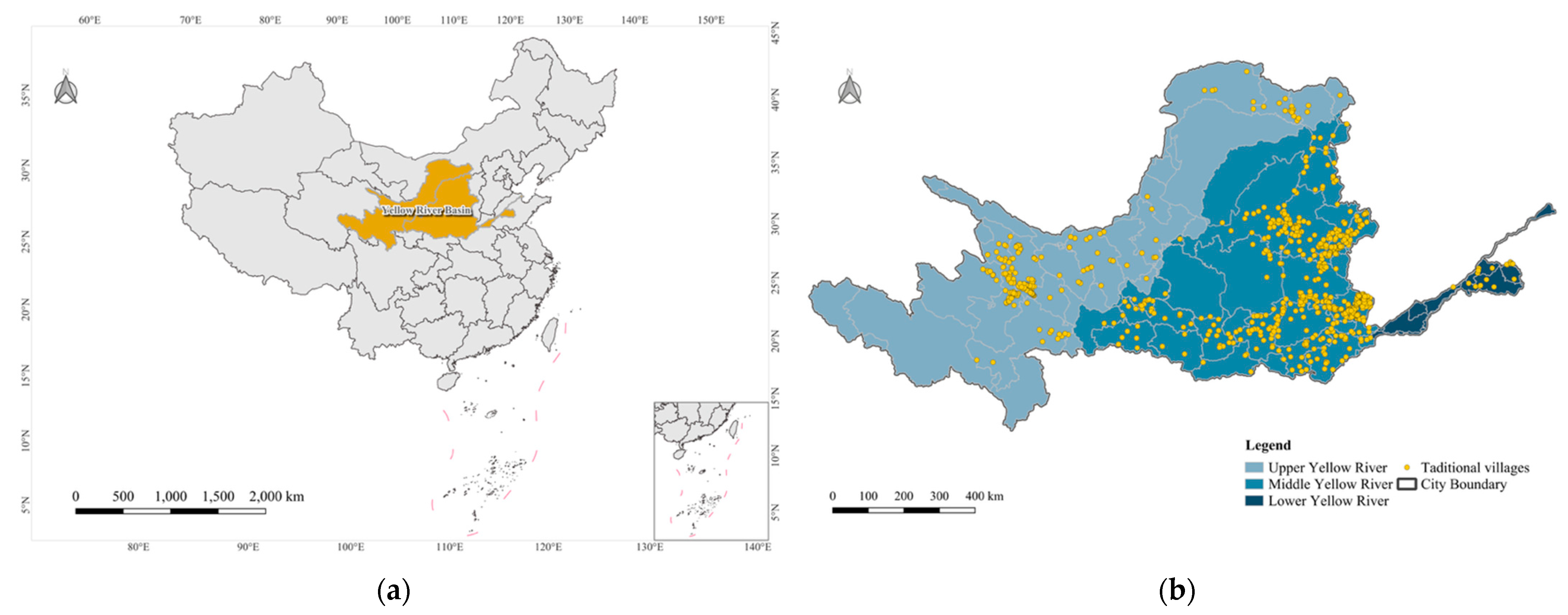
2.1. Study Area
2.2. Data Source
2.3. Research Methods
3. Results
3.1. Spatial Distribution Characteristics
3.1.1. Spatial Distribution Patterns
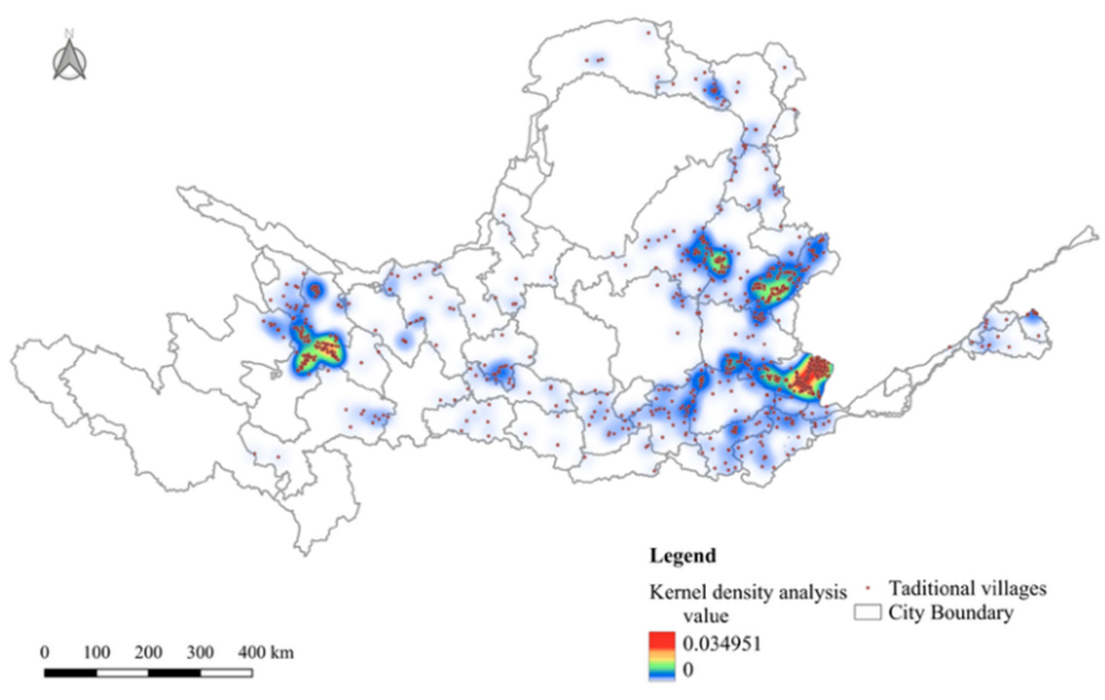
3.1.2. Kernel Density Estimation Analysis
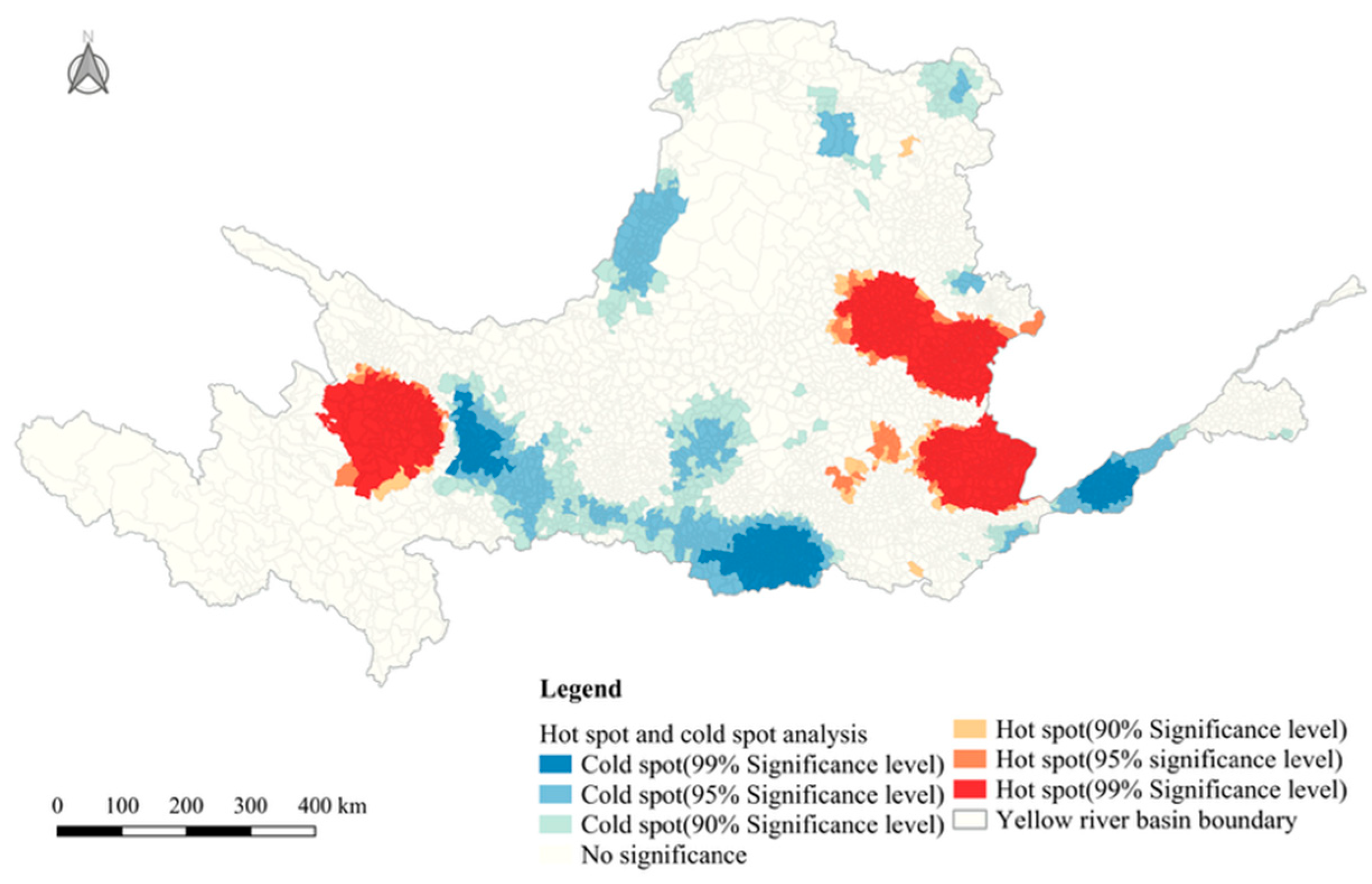
3.1.3. Spatial Autocorrelation Analysis
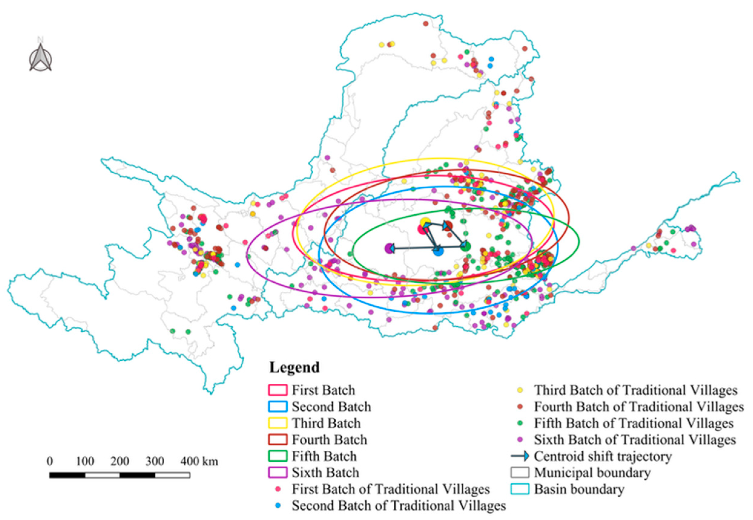
3.1.4. Directional Distribution of Traditional Villages
3.2. Factors Influencing Spatial Distribution
3.2.1. Variable Selection
3.2.2. Results of the Analysis of Influencing Factors
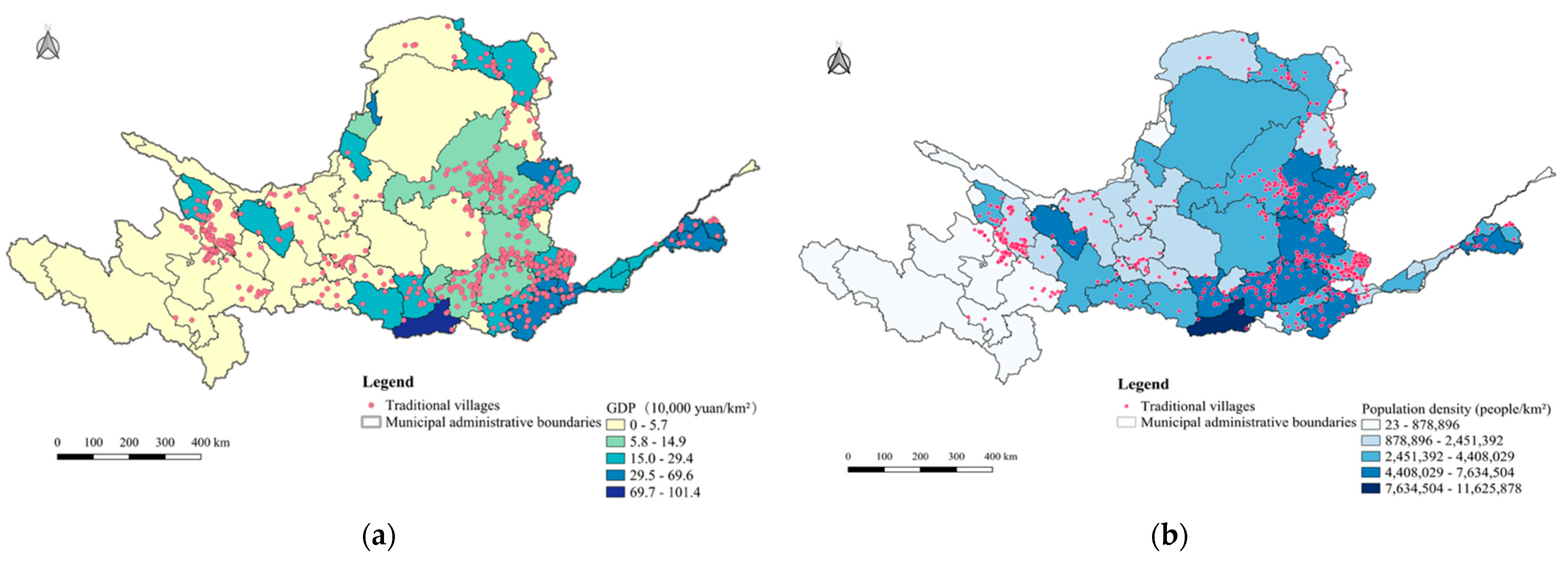
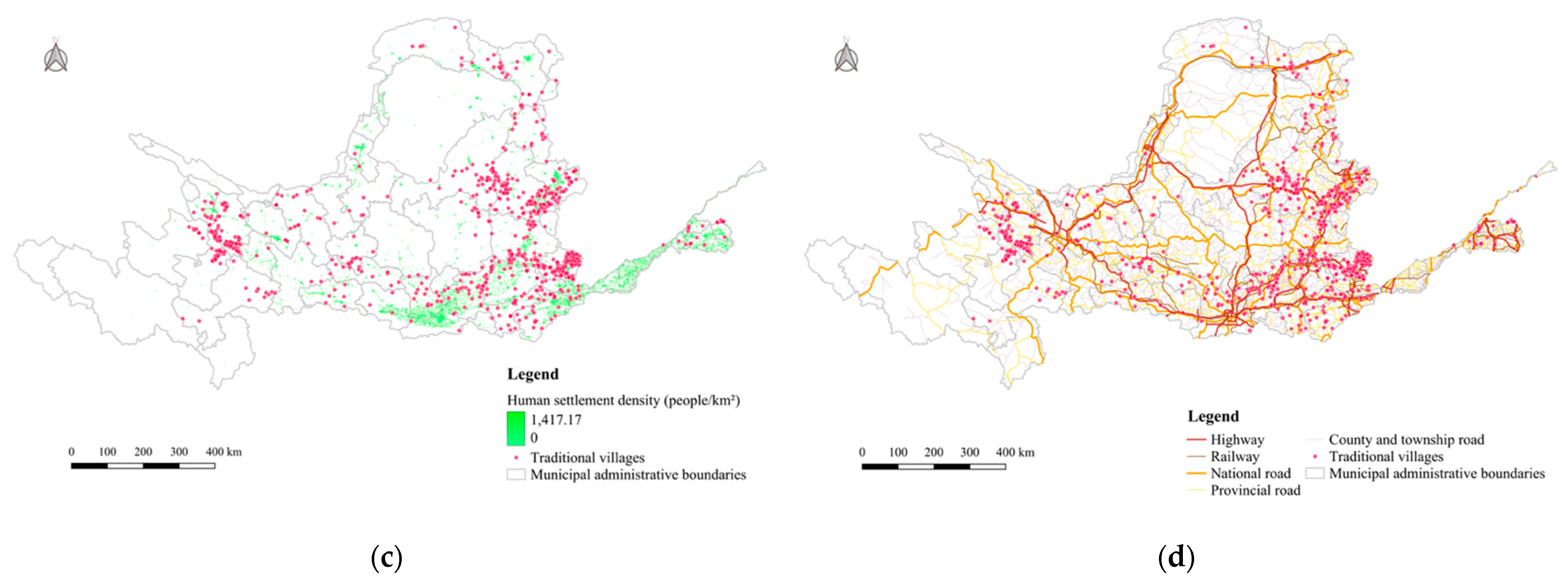
3.3. Spatial Heterogeneity Analysis
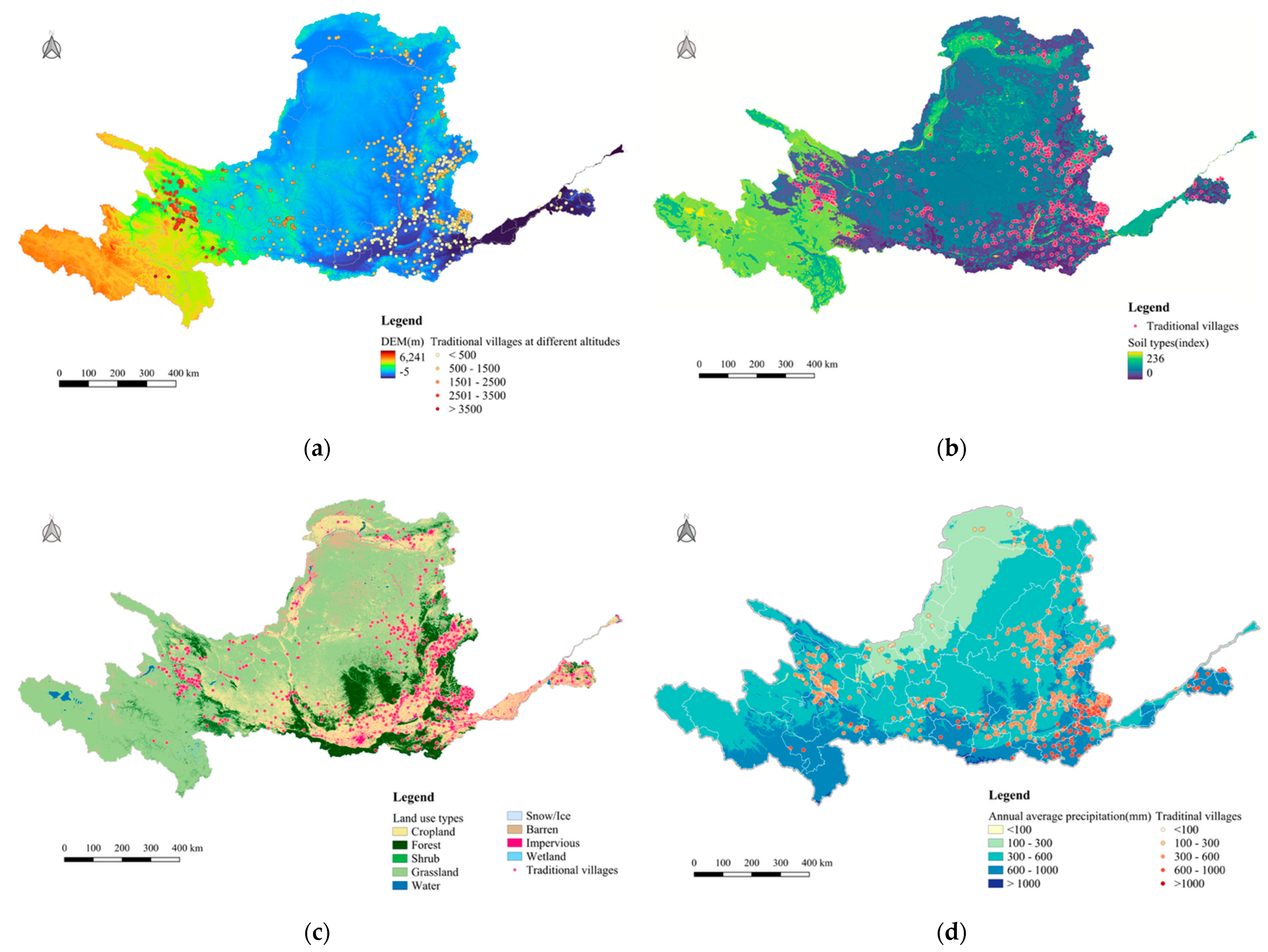
3.3.1. Topography
3.3.2. Climate
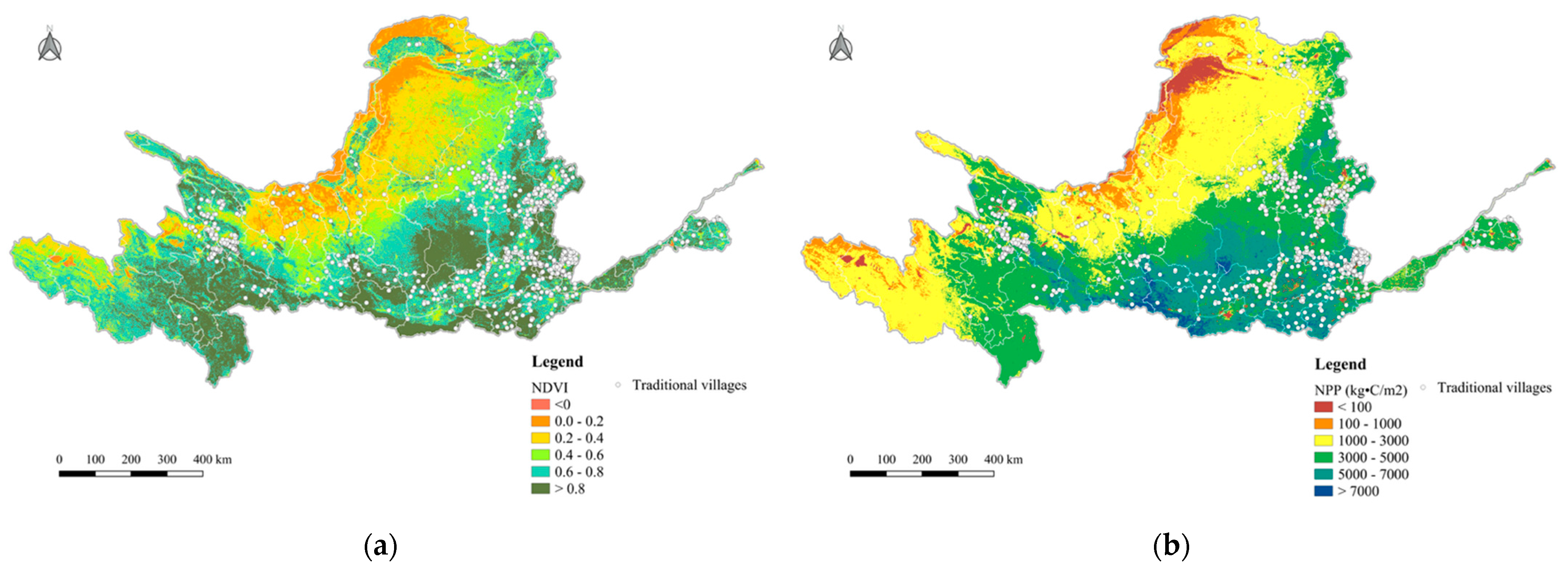
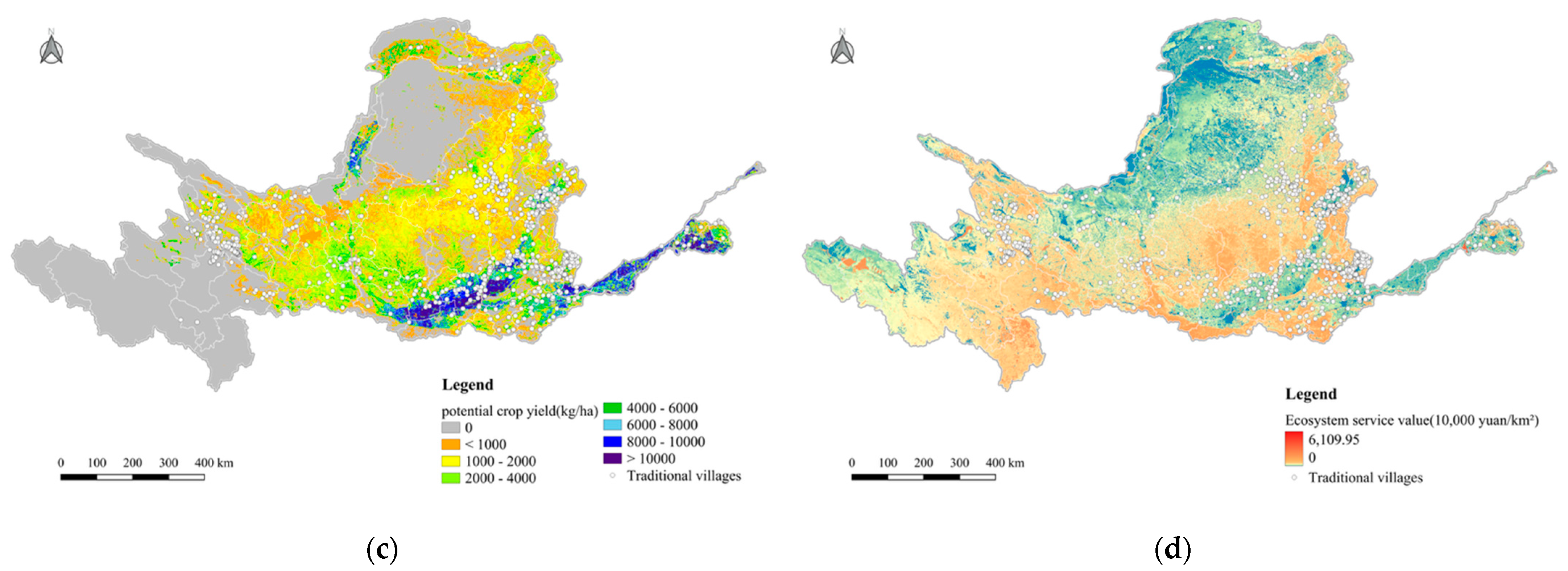
3.3.3. Ecology
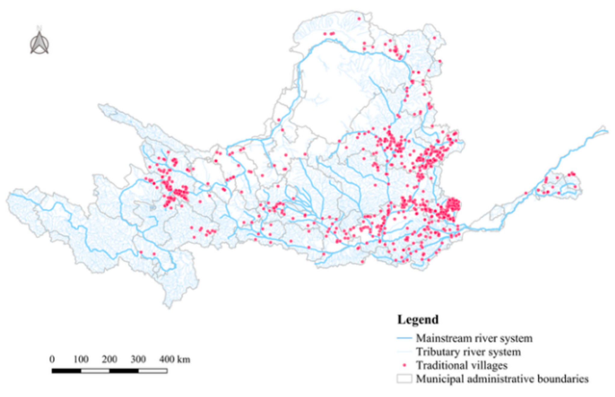
3.3.4. Hydrology
3.3.5. Economy
3.3.6. Population
3.3.7. Transportation
3.3.8. Culture
4. Discussion
5. Conclusions
- The traditional villages in the Yellow River Basin in China exhibit a clustered spatial distribution at the watershed scale, with significant spatial heterogeneity. While the upper and middle reaches show notable clustering, the lower reaches exhibit a more random, dispersed pattern. Kernel Density Estimation and hotspot analysis identify two major core clusters: Jincheng–Jinzhong–Lvliang in Shanxi and Haidong–Huangnan in Qinghai. The hotspot areas contain 63.9% of all traditional villages, forming a hierarchical spatial pattern, with dispersed villages in the upper reaches, dense clusters in the middle, and a lower density downstream.
- The spatial distribution of villages has evolved dynamically in response to the environmental conditions of the river basin. Standard deviation ellipse and centroid migration analyses show a dynamic shift in the distribution centers of the six batches of designated villages, following a “north–south–north–east–south–west” trajectory. The azimuth angle of the traditional village locations remains stable between 86.6° and 88.1°, mirroring the west–east orientation of the Yellow River.
- The analysis of the driving factors indicates that the proximity to county centers, river distance, and agricultural production potential are key determinants of village distribution, reflecting a strong reliance on ecological resources and spatial accessibility. The GWR analysis confirms that both natural and socio-economic factors jointly influence the spatial patterns of traditional villages. In the upper reaches, villages depend more on natural environmental conditions, with elevation and precipitation being particularly influential. In the middle and lower reaches, economic development and transport accessibility dominate village evolution. Factors like road density become more prominent in the middle reaches. Additionally, cultural heritage protection units have a stronger influence in the remote upper reaches, underscoring the role of institutional cultural support in preserving villages’ integrity.
5.1. Managerial Insights
- Develop a multi-center, multi-type protection system to support regionally differentiated governance. Traditional villages in the Yellow River Basin show distinct spatial and ecological characteristics. These differences require tailored protection strategies. In the upper reaches, the villages are mainly located in plateau and river valley areas. These areas face strong ecological constraints and rely heavily on cultural heritage. Efforts here should focus on ecological redline management. Emphasis should be placed on revitalizing cultural heritage in harmony with natural ecosystems to foster cultural and ecological coexistence. In the middle reaches, characterized by dense village clusters and rich cultural assets, strategies should prioritize large-scale, contiguous protection in the core areas. Efforts should integrate intangible cultural heritage resources, support the development of and cultivate distinctive industries, and build a synergistic culture–ecology–economy system. In the lower reaches, villages are more dispersed and subject to both flood risks and urban expansion. Protective strategies should focus on building ecological buffer zones and implementing rational land use planning to contain development boundaries and reduce protection pressure.
- Promote the development of “linear cultural corridors” to enhance spatial connectivity and cultural identity. The spatial distribution of traditional villages closely follows the Yellow River and its major tributaries, demonstrating a natural alignment for integrated cultural and ecological conservation. It is recommended to establish linear cultural corridors along the mainstream of the river and key tributaries, including the Datong River, Tao River, and Geshi River in the upper reaches, and the Fen River, Qin River, Daxiangzang River, and Changyuan River in the middle reaches. These corridors would enhance spatial continuity, reinforce regional cultural identity, and serve as axes for village cluster linkage, facilitating holistic protection and development.
- Establish a cross-regional watershed governance mechanism to enable systematic and coordinated protection. The Yellow River Basin spans multiple provinces and administrative regions, requiring coordinated governance beyond conventional administrative boundaries. A watershed-based governance framework should be adopted to promote cross-jurisdictional collaboration and policy coordination at the sub-basin level. This shift from an “administrative boundary” mindset to an “ecological logic” framework enables differentiated management, that aligns more closely with the natural landscape and supports integrated, multi-scalar conservation.
- Strengthen transportation and policy support to improve village resilience and development capacity. Findings from the GWR analysis indicate that road density and distance to county centers are key factors of traditional village distribution. Targeted infrastructure investment in the underdeveloped central and western regions is essential to improve and enhance external connectivity. At the same time, a robust cultural heritage protection policy framework should be established, supported by dedicated funding mechanisms to attract social capital and encourage sustainable rural revitalization and economic empowerment.
5.2. Future Research
- The current analysis is conducted at the prefecture level, which restricts the ability to capture structural evolution within villages and finer scale spatial heterogeneity. Future research could employ clustering analysis to develop hierarchical conservation frameworks tailored to different village types, ensuring localized and context-sensitive protection measures.
- Socio-psychological and institutional factors such as cultural identity, resident participation, and policy responsiveness were not effectively quantified in this study. Future studies could employ methods such as questionnaire surveys, semi-structured interviews, and text mining to examine villagers’ cultural attitudes, behavioral intentions, and policy acceptance. These approaches would support the development of an integrated “behavior–institution–space” analytical framework, offering a more comprehensive foundation for preserving living heritage and informing policy design.
- This study relies on static data and does not capture the temporal dynamics or future trajectories of traditional village evolution. Future research could incorporate multi-period remote sensing imagery and panel data, applying time series analysis and multi-scale modeling to track dynamic changes and enable more targeted intervention. This would provide stronger support for building resilient and adaptive rural systems.
Author Contributions
Funding
Institutional Review Board Statement
Informed Consent Statement
Data Availability Statement
Conflicts of Interest
References
- Wang, X.; Zhu, Q. Influencing factors of traditional village protection and development from the perspective of resilience theory. Land 2022, 11, 2314. [Google Scholar] [CrossRef]
- Hu, B.; Wu, C. The current situation and development trends of research on Chinese village culture. Sci. Soc. 2014, 6, 99–104. [Google Scholar]
- Zheng, X.; Herman, S.S.B.; Salih, S.A.; Ismail, S.B. Sustainable characteristics of traditional villages: A systematic literature review based on the Four-Pillar theory of sustainable development. Sustainability 2024, 16, 10352. [Google Scholar] [CrossRef]
- Li, F.; Xia, H.; Miao, J.; Yang, J. Changes of the ecological environment status in villages under the background of traditional village preservation: A case study in Enshi Tujia and Miao Autonomous Prefecture. Sci. Rep. 2025, 15, 1504. [Google Scholar] [CrossRef]
- Jiang, Y.; Duan, J.; Zhang, Y. The spontaneous spatial restructuring of traditional village based on an analysis of social relationship: A case in Fuling, Fujian China. Habitat Int. 2025, 157, 103309. [Google Scholar] [CrossRef]
- Widyaswari, M.; Susanto, S.F.; Nusantara, W.; Agustina, I. Integration of Local Wisdom in Sustainable Tourism Development Strategy in the Traditional Village of Ende Tribe. In International Joint Conference on Arts and Humanities 2024 (IJCAH 2024). Atlantis Press 2025, 2, 1675–1694. [Google Scholar]
- Xue, Q.; Huang, Y. The spatial relationship and influence mechanism of traditional villages and intangible cultural heritage: A case study of the upper reaches of the Yellow River Basin. Humanit. Soc. Sci. Commun. 2025, 12, 142. [Google Scholar] [CrossRef]
- Liu, P.L.; Dong, S.S. Study of landscape-image of Chinese ancient village. Geogr. Res. 1998, 17, 31–38. [Google Scholar]
- Song, J.; Wang, M. An analysis of the current situation and problems of the digital protection of Chinese intangible cultural heritage. Cult. Herit. 2015, 6, 1–9. [Google Scholar]
- Yang, L.; Liu, P. The inheritance and its evaluation system of traditional village culture: A case study of traditional village in Hunan province. Econ. Geogr. 2017, 37, 203–210. [Google Scholar]
- Li, B.H.; Luo, Q.; Liu, P.L.; Zhang, J.Q. Knowledge maps analysis of traditional villages research in China based on the Citespace method. Econ. Geogr. 2017, 37, 207–214. [Google Scholar]
- Liu, C.; Xu, M. Characteristics and influencing factors on the hollowing of traditional villages—Taking 2645 villages from the Chinese traditional village catalogue (Batch 5) as an example. Int. J. Environ. Res. Public Health 2021, 18, 12759. [Google Scholar] [CrossRef]
- Ministry of Housing and Urban–Rural Development of China; Ministry of Culture and Tourism of China; National Administration of Cultural Heritage of China; Ministry of Finance of China; Ministry of Natural Resources of China; Ministry of Agriculture and Rural Affairs of China. Notice on Announcing the List of the Sixth Batch of Villages Included in the List of Traditional Villages in China [EB/OL]; Ministry of Housing and Urban–Rural Development of the People’s Republic of China: Beijing, China, 2023. (In Chinese)
- Zuo, Q.; Wu, Q.; Jiang, L.; Zhang, W. Multi-scale regional definition and its application selection in the Yellow River Basin. Hydro Sci. Eng. 2022, 5, 12–20. [Google Scholar] [CrossRef]
- Zhang, J.; Zhang, R.; Li, Q.; Zhang, X.; He, X. Spatial Differentiation and Differentiated Development Paths of Traditional Villages in Yunnan Province. Land 2023, 12, 1663. [Google Scholar] [CrossRef]
- Wang, G.X. New trends in migration and urbanization in China: A preliminary investigation based on the seventh census data. Popul. Econ. 2021, 5, 36–55. [Google Scholar]
- Shao, Y.; Cui, J.Y. Space and landscape evolution mechanism and resource governance characteristics of traditional villages from the perspective of social-ecological system. Landsc. Archit. 2024, 31, 115–124. [Google Scholar] [CrossRef]
- Li, B.H.; Zeng, C.; Dou, Y.D.; Liu, P.; Chen, C. Change of human settlement environment and driving mechanism in traditional villages based on living-production-ecological space: A case study of Lanxi Village, Jiangyong County, Hunan Province. Prog. Geogr. 2018, 37, 677–687. [Google Scholar]
- Li, B.; Zeng, R.; Liu, P. Human settlement evolution of traditional village based on theory of complex adaptive system: A case study of Zhangguying Village. Geogr. Res. 2018, 37, 1982–1996. [Google Scholar]
- Liu, C.; Xu, M.; Liu, P.; Zeng, F. Cultural landscape protection compensation model of traditional villages and its application in Xiangxi. Acta Geogr. Sin. 2020, 75, 382–397. [Google Scholar]
- Gao, C.; Wu, Y.; Bian, C.; Gao, X. Spatial characteristics and influencing factors of Chinese traditional villages in eight provinces the Yellow River flows through. River Res. Appl. 2023, 39, 1255–1269. [Google Scholar] [CrossRef]
- Yang, S.J.; Kim, Y.S.; Park, Y.H. A study on the disposition characteristics of spatial composition elements in traditional Korean villages—Focused on the space syntax analysis. J. Archit. Inst. Korea Plan. Des. 2006, 22, 169–178. [Google Scholar]
- Lee, S.H. Comparative evaluation of gate and wall color in traditional village—A case study of traditional housing on Hahe village in Korea and Makabe-machi in Japan. Arch. Des. Res. 2011, 24, 299–308. [Google Scholar]
- Ali, J.R.; Hill, R.D. Feng Shui and the orientation of traditional villages in the New Territories, Hong Kong, China. J. R. Asiat. Soc. Hong Kong Branch 2005, 45, 27–39. [Google Scholar]
- Li, B.; Liu, P.; Dou, Y.; Zeng, C.; Chen, C. Research progress on transformation development of traditional villages’ human settlement in China. Geogr. Res. 2017, 36, 1886–1900. [Google Scholar]
- Wei, C.; Liu, F.; Yang, C.; Cheng, Y.X.; Shen, J. Challenges and trends in the preservation and utilization of traditional villages in rapidly urbanized area: A case study of the Pearl River Delta. J. Nat. Resour. 2024, 39, 1867–1886. [Google Scholar] [CrossRef]
- Li, M.; Yan, Y.; Ying, Z.; Zhou, L. Measuring villagers’ perceptions of changes in the landscape values of traditional villages. ISPRS Int. J. Geo Inf. 2024, 13, 60. [Google Scholar] [CrossRef]
- Yu, X.; Leng, J.; Zhou, H. Cognitive preferences for architectural renovation strategies in traditional villages combining subjective evaluation and eye tracking. Front. Archit. Res. 2025, 14, 1017–1034. [Google Scholar] [CrossRef]
- Chen, Y.; Li, R. Spatial Distribution and Type Division of Traditional Villages in Zhejiang Province. Sustainability 2024, 16, 5262. [Google Scholar] [CrossRef]
- Byun, K.H.; Kang, E.J.; Lee, J.L.; Kim, K.H. A study on establishments and characteristics of spiritual spaces in a traditional village of Gapa island, Jejudo. J. Archit. Inst. Korea Plan. Des. 2014, 30, 161–168. [Google Scholar] [CrossRef]
- Zhou, M.; Chu, S.; Du, X. Safeguarding traditional villages in China: The role and challenges of rural heritage preservation. Built Herit. 2019, 3, 81–93. [Google Scholar] [CrossRef]
- Xi, J.; Wang, X.; Kong, Q.; Zhang, N. Spatial morphology evolution of rural settlements induced by tourism: A comparative study of three villages in Yesanpo tourism area. J. Geogr. Sci. 2015, 25, 497–511. [Google Scholar] [CrossRef]
- Reza, M.; Noer, M.; Yonariza, A. Agricultural extension planning pattern at level of nagari (Minangkabau traditional village) based on bonding capital in group of farmers in Lima Puluh Kota district, Indonesia. Int. J. Adv. Sci. Eng. Inf. Technol. 2019, 9, 1357–1363. [Google Scholar] [CrossRef]
- Meng, Q.; Wang, C.; Xu, T.; Pi, H.; Wei, Y. Evaluation of the sustainable development of traditional ethnic village tourist destinations: A case study of Jiaju Tibetan Village in Danba county, China. Land 2022, 11, 1008. [Google Scholar] [CrossRef]
- Xu, Y.; Wang, T.; Liu, W.; Zhang, R.; Hu, Y.; Gao, W.; Chen, Y. Rural system sustainability evaluation based on emergy analysis: An empirical study of 321 villages in China. J. Clean. Prod. 2023, 389, 136088. [Google Scholar] [CrossRef]
- Liu, D.; Hu, J.; Chen, J.; Xu, X. The study of spatial distribution pattern of traditional villages in China. China Popul. Resour. Environ. 2014, 24, 157–162. [Google Scholar]
- Gong, S.; Li, Z.; Hu, J.; Wei, Y.H. The spatial distribution and evolution of ancient villages in Shanxi province. Sci. Geogr. Sin. 2017, 37, 416–425. [Google Scholar]
- Yoo, B.H. A study on the design development of rural and traditional village for sightseeing resources. Arch. Des. Res. 2006, 19, 235–242. [Google Scholar]
- Hu, J.L.; Teng, Y.B.; Fan, Y.M.; Li, L.P. Spatial distribution and influencing factors of traditional villages in Guangxi Zhuang autonomous region. J. Guilin Univ. Technol. 2023, 41, 580–588. [Google Scholar]
- Jeong, S.Y.; Yu, I.H.; Yeo, J.T.; Ko, D.W. The perceptions and value attitudes toward becoming tourist destination of traditional folk village. J. Korea Plan. Assoc. 2009, 44, 245–258. [Google Scholar]
- Astuti, K.A.; Darma, G.S. Community-based tourism: Measuring readiness of artificial intelligence on traditional village. Int. J. Soc. Sci. Humanit. 2019, 3, 81–89. [Google Scholar] [CrossRef]
- Xu, Y.; Lu, L. Probing the long-term evolution of traditional village tourism destinations from a glocalisation perspective: A case study of Wuzhen in Zhejiang province, China. Habitat Int. 2024, 148, 103073. [Google Scholar] [CrossRef]
- Wang, S.; Liping, Y.; Arif, M. Evolutionary analysis of ecological-production-living space-carrying capacity in tourism-centric traditional villages in Guangxi, China. J. Environ. Manag. 2025, 375, 124182. [Google Scholar] [CrossRef]
- Cheng, Y.; Fei, X.; Luo, L.; Kong, X.; Zhang, J. Social network analysis of heterogeneous subjects driving spatial commercialization of traditional villages: A case study of Tanka Fishing Village in Lingshui Li Autonomous county, China. Habitat Int. 2025, 155, 103235. [Google Scholar] [CrossRef]
- Zhang, Q.; Kim, E.; Yang, C.; Cao, F. Rural revitalization: Sustainable strategy for the development of cultural landscape of traditional villages through optimized IPA approach. J. Cult. Herit. Manag. Sustain. Dev. 2023, 13, 66–86. [Google Scholar] [CrossRef]
- Li, X.; Zhang, Y. Study on the Genetic Variation Mechanism and Restoration of the Water Village Landscape in Southern Jiangsu. J. South Archit. 2025, 1, 81–92. [Google Scholar] [CrossRef]
- Kong, L.Y.; Xu, X.D.; Liu, K.; Zhang, R. Research on the systematic characteristics and mechanism of the transformation and development of traditional villages in scenic spots from the perspective of ‘production, living and ecology’. Chin. Landsc. Archit. 2023, 39, 111–116. [Google Scholar]
- Chen, H.L.; Xu, J.B.; Yang, W.Y.; Cao, X.S. Study on the spatial correlation between traditional villages and poverty-stricken villages and its influencing factors in China. J. Nat. Resour. 2021, 36, 3156–3169. [Google Scholar] [CrossRef]
- Rui, Y.; Yang, K.; Li, Y.; Lin, J.; Jin, T. Spatio-temporal dynamic characteristics and revitalization strategies of characteristic protection villages in China: Based on the perspective of population ecology. Geogr. Res. 2022, 41, 2203–2220. [Google Scholar]
- Yang, Y.; Hu, J.; Liu, D.J.; Li, Y.J.; Chen, Y.; Hu, S.L. Spatial differentiation of ethnic traditional villages in Guizhou province and the influencing factors. J. Arid. Land Resour. Environ. 2022, 36, 178–185. [Google Scholar]
- He, Y.B.; Zhou, M.H.; Jia, Y.L.; Du, Y.Q.; Ma, Y. Tourism high-quality development of traditional villages based on resilience measurement: A case study of Henan Province. Econ. Geogr. 2022, 42, 222–231. [Google Scholar]
- Liu, W.; Xue, Y.; Shang, C. Spatial distribution analysis and driving factors of traditional villages in Henan province: A comprehensive approach via geospatial techniques and statistical models. Herit. Sci. 2023, 11, 185. [Google Scholar] [CrossRef]
- Huang, Y.; Xue, Q. Spatio-Temporal distribution characteristics and driving factors of traditional villages in the Yellow River Basin. PLoS ONE 2024, 19, e0303396. [Google Scholar] [CrossRef]
- Zhang, Z.C.; Liu, X.Z.; Liu, W. Comprehensive evaluation of the quality improvement of Gaoyi ancient village based on AHP-entropy method. Furnit. Inter. Des. 2023, 30, 124–131. [Google Scholar] [CrossRef]
- Huang, H.J.; Miao, H.; Li, S.; Wang, Y. Spatial Pattern and Influence Mechanism of Traditional Villages in Northwest China. Econ. Geogr. 2021, 41, 233–240. [Google Scholar]
- Xu, X.; Genovese, P.V.; Zhao, Y.; Liu, Y.; Woldesemayat, E.M.; Zoure, A.N. Geographical distribution characteristics of ethnic minority villages in Fujian and their relationship with topographic factors. Sustainability 2022, 14, 7727. [Google Scholar] [CrossRef]
- Zhu, L. Landscape Painting reconstruction in the protection and development of traditional village features: A case study of Taoyuan village in Qimen county, Anhui province. Shanghai Urban Plan. Rev. 2023, 5, 57–64. [Google Scholar]
- Long, T.; Ișık, C.; Yan, J.; Zhong, Q. Promoting the sustainable development of traditional villages: Exploring the comprehensive assessment, spatial and temporal evolution, and internal and external impacts of traditional village human settlements in hunan province. Heliyon 2024, 10, e32439. [Google Scholar] [CrossRef]
- Bi, S.; Du, J.; Tian, Z.; Zhang, Y. Investigating the spatial distribution mechanisms of traditional villages from the human geography region: A case study of Jiangnan, China. Ecol. Inform. 2024, 81, 102649. [Google Scholar] [CrossRef]
- Zhao, X.; Xue, P.; Wang, F.; Qin, Y.; Duan, X.; Yang, Z. How to become one? The modern bond of traditional villages in centralized contiguous protection and utilization areas in China. Habitat Int. 2024, 145, 103018. [Google Scholar] [CrossRef]
- Wu, Y.; Miao, M.; Wu, Y.; Zhu, H.; Li, X.; Candeias, A. The Research on the Construction of Traditional Village Heritage Corridors in the Taihu Lake Region Based on the Current Effective Conductance (CEC) Theory. Buildings 2025, 15, 472. [Google Scholar] [CrossRef]
- Zhao, H.Y.; Li, Y.B.; Che, Y. Assessment of the social values of ecosystem services in traditional villages based on SolVES model: A case study of Jinjiang wooden house village. Chin. Landsc. Archit. 2022, 38, 76–81. [Google Scholar]
- He, Y.; Yin, C.; Mao, X.; Guo, Y. Performance assessment and influencing factors of human settlement improvement in traditional villages based on Balanced Scorecard theory: A case study of Jiaozuo, China. Front. Sustain. Food Syst. 2025, 8, 1538029. [Google Scholar] [CrossRef]
- Kong, D.; Fei, X.; Lu, Z.; Lin, X.; Cai, M.; Chen, Z. Regional Color Study of Traditional Village Based on Random Forest Model: Taking the Minjiang River Basin as an Example. Buildings 2025, 15, 524. [Google Scholar] [CrossRef]
- Lin, Z.; Chen, K.; Jiao, K.; Li, Z. Spatio-temporal characteristics of traditional village landscape pattern and its influencing factors from the perspective of tourism development: A case study of Huangcheng Village, China. J. Asian Archit. Build. Eng. 2024, 24, 1000–1012. [Google Scholar] [CrossRef]
- Feng, X.; Hu, M.; Somenahalli, S.; Zhang, W.; Liu, K.; Li, M.; Zhou, Z.; Li, F. Study on the Spatial Morphology of Ando Tibetan Traditional Villages in China: A Case of Traditional Villages in Huangnan Prefecture. Sustainability 2025, 17, 1353. [Google Scholar] [CrossRef]
- Silverman, B.W. Density Estimation for Statistics and Data Analysis, 1st ed.; Routledge: New York, NY, USA, 1998. [Google Scholar]
- Ord, J.K.; Getis, A. Local spatial autocorrelation statistics: Distributional issues and an application. Geogr. Anal. 1995, 27, 286–306. [Google Scholar] [CrossRef]
- Wang, J.F.; Xu, C.D. Geographical detector: Principles and prospects. Acta Geogr. Sin. 2017, 72, 116–134. [Google Scholar]
- Mu, S.L.; Yuan, Z.H.; Wuritaoketaohu. Spatial differentiation pattern and impacting mechanism of intangible cultural heritages in the Yellow River Basin. J. Desert Res. 2022, 42, 255–265. [Google Scholar]
- Fortheringham, A.S.; Chanrlton, M.; Brunsdon, C. The geographically of parameter space: An investigation of spatial nonstationarity. Int. J. Geogr. Inf. Syst. 1996, 10, 605–627. [Google Scholar] [CrossRef]
- Bian, J.; Chen, W.; Zeng, J. Spatial distribution characteristics and influencing factors of traditional villages in China. Int. J. Environ. Res. Public Health 2022, 19, 4627. [Google Scholar] [CrossRef]
- Ma, Y.; Zhang, Q.; Huang, L. Spatial distribution characteristics and influencing factors of traditional villages in Fujian province, China. Humanit. Soc. Sci. Commun. 2023, 10, 883. [Google Scholar] [CrossRef]
- Jia, A.; Liang, X.; Wen, X.; Yun, X.; Ren, L.; Yun, Y. GIS-Based analysis of the spatial distribution and influencing factors of traditional villages in Hebei province, China. Sustainability 2023, 15, 9089. [Google Scholar] [CrossRef]
- Wu, K.; Su, W.; Ye, S.; Li, W.; Cao, Y.; Jia, Z. Analysis on the geographical pattern and driving force of traditional villages based on GIS and GeoDetector: A Case Study of Guizhou, China. Sci. Rep. 2023, 13, 20659. [Google Scholar] [CrossRef] [PubMed]
- Li, S.; Song, Y.; Xu, H.; Li, Y.; Zhou, S. Spatial distribution characteristics and driving factors for traditional villages in areas of China based on GWR modeling and GeoDetector: A case study of the Awa Mountain area. Sustainability 2023, 15, 3443. [Google Scholar] [CrossRef]
- Wang, Z.; Zhu, J.; Wu, Z. Study on the spatial distribution characteristics of traditional villages and their response to the water network system in the lower Yangtze River Basin. Sci. Rep. 2024, 14, 22586. [Google Scholar] [CrossRef]
- Hu, K.; Lin, W.; Fan, L.; Yang, S.; Zhang, T. Spatial differentiation and influencing factors of traditional villages in Fujian, China: A Watershed Perspective. Sustainability 2024, 16, 4787. [Google Scholar] [CrossRef]
- Luo, L.; Xu, X.; Xi, C. Assessing the impact of urban expansion on potential crop yield in China during 1990–2010. Food Secur. 2015, 1, 33–43. [Google Scholar] [CrossRef]
- Li, T.; Li, C.; Zhang, R.; Cong, Z.; Mao, Y. Spatial heterogeneity and influence factors of traditional villages in the Wuling mountain area, Hunan Province, China based on multiscale geographically weighted regression. Buildings 2023, 13, 294. [Google Scholar] [CrossRef]

| River Basin | Province (Region) | City | Number of Traditional Villages | Proportion (%) |
|---|---|---|---|---|
| Upper Reaches | Qinghai | Haidong, Huangnan, Xining, Hainan | 153 | 17.23% |
| Gansu | Baiyin, Gannan, Lanzhou, Linxia | 35 | 3.94% | |
| Ningxia | Guyuan, Wuzhong, Zhongwei, Yinchuan | 10 | 1.13% | |
| Inner Mongolia | Baotou, Hohhot, Bayannur, Ulanqab | 23 | 2.59% | |
| Middle Reaches | Ningxia | Guyuan, Wuzhong | 16 | 1.80% |
| Inner Mongolia | Hohhot, Ordos | 6 | 0.68% | |
| Shaanxi | Yulin, Weinan, Xianyang, Yan’an, Xi’an, Tongchuan, Baoji | 120 | 13.51% | |
| Gansu | Tianshui, Pingliang, Dingxi, Qingyang | 18 | 2.03% | |
| Henan | Luoyang, Sanmenxia, Jiyuan, Jiaozuo, Zhengzhou | 62 | 6.98% | |
| Shanxi | Jincheng, Luliang, Jincheng, Linfen, Yuncheng, Xinzhou, Taiyuan, Changzhi, Shuozhou | 426 | 47.97% | |
| Lower Reaches | Henan | Puyang | 1 | 0.11% |
| Shandong | Jinan, Taian | 18 | 2.03% | |
| Total Basin | - | - | 888 | 100% |
| Basin Region | ra/km | re/km | R | p-Value | Type |
|---|---|---|---|---|---|
| Upper Reaches | 8.50 | 21.69 | 0.39 | 0.000 | Clustered |
| Middle Reaches | 7.31 | 13.82 | 0.53 | 0.000 | Clustered |
| Lower Reaches | 13.25 | 11.80 | 1.12 | 0.304 | Random |
| Overall | 7.66 | 18.99 | 0.40 | 0.000 | Clustered |
| Batch | Mean Longitude (°) | Mean Latitude (°) | Standard Deviation Along X-Axis (km) | Standard Deviation Along Y-Axis (km) | Eccentricity | Azimuth (°) |
|---|---|---|---|---|---|---|
| 1 | 109.1376 | 36.5129 | 4.15 | 1.35 | 0.946 | 88.1° |
| 2 | 109.6112 | 35.9510 | 3.81 | 1.64 | 0.903 | 88.1° |
| 3 | 109.2033 | 36.6733 | 4.10 | 1.61 | 0.919 | 86.6° |
| 4 | 109.8793 | 36.6048 | 3.89 | 1.40 | 0.933 | 86.9° |
| 5 | 110.4838 | 36.0648 | 3.61 | 0.97 | 0.964 | 87.8° |
| 6 | 108.0534 | 36.0019 | 4.54 | 1.25 | 0.961 | 87.8° |
| Variable | Dimension | Indicator | Calculation Method | Unit |
|---|---|---|---|---|
| Independent variable | traditional village density | Number of traditional villages in each prefecture-level city within the basin | count | |
| Dependent variables | ||||
| Natural environmental factors | topography | elevation (x1) | Average elevation of each prefecture-level city within the basin | m |
| topographic relief (x2) | Elevation height difference between the highest and lowest points of each prefecture-level city within the region | m | ||
| slope (x3) | Average slope of each prefecture-level city’s terrain, representing the inclination of the surface | ° | ||
| aspect (x4) | Average aspect of each prefecture-level city, expressed as the angle between the direction of surface inclination and the true north | ° | ||
| climate | average annual temperature (x5) | Average annual temperature for each prefecture-level city, interpolated from spatial climatic grid data | ℃ | |
| average annual precipitation (x6) | Average annual precipitation for each prefecture-level city, interpolated from spatial climatic grid data | mm | ||
| ecology | normalized difference vegetation index (NDVI) (x7) | Normalized difference vegetation index, using the maximum value composition method | - | |
| net primary productivity (NPP) (x8) | Net primary productivity, carbon storage per unit area | kg·C/m2 | ||
| ecosystem service value (x9) | Total value of four ecosystem services: provisioning, regulating, supporting, and cultural services | 10,000 yuan/km2 | ||
| potential crop yield (x10) | Estimated cropland production potential based on the GAEZ model, considering five major crops: wheat, corn, rice, soybean, and sugarcane | kg/ha | ||
| hydrology | river network density (x11) | Ratio of river length to regional area | km/km2 | |
| distance to river (x12) | Average distance from traditional villages to the nearest river | km | ||
| Social and economic factors | economy | GDP (x13) | GDP per unit area, derived from land use types, nighttime light intensity, and residential density, spatialized into a 1 km spatial grid | 10,000 yuan/km2 |
| population | population density (x14) | Population density per unit area, derived from land use types, nighttime light intensity, and residential density, spatialized into a 1 km grid | people/km2 | |
| transportation | distance to county-level center (x15) | Average distance from traditional villages to the county-level administrative center | km | |
| road density (x16) | Ratio of road length to regional area | km/km2 | ||
| culture | cultural heritage protection unit density (x17) | Number of national and provincial cultural heritage protection units per prefecture-level city | count |
| Variable | Detection Factor | q | p-Value |
|---|---|---|---|
| x1 | elevation | 0.149 | 0.086 * |
| x2 | topographic relief | 0.133 | 0.050 * |
| x3 | slope | 0.148 | 0.016 ** |
| x4 | aspect | 0.108 | 0.183 |
| x5 | average annual temperature | 0.072 | 0.398 |
| x6 | average annual precipitation | 0.102 | 0.200 |
| x7 | normalized difference vegetation index (NDVI) | 0.110 | 0.315 |
| x8 | net primary productivity (NPP) | 0.190 | 0.006 *** |
| x9 | ecosystem service value | 0.047 | 0.518 |
| x10 | potential crop yield | 0.235 | 0.003 *** |
| x11 | river network density | 0.179 | 0.005 *** |
| x12 | distance to river | 0.572 | 0.000 *** |
| x13 | GDP | 0.148 | 0.093 * |
| x14 | population density | 0.042 | 0.561 |
| x15 | distance to county-level center | 0.682 | 0.000 *** |
| x16 | road density | 0.141 | 0.037 ** |
| x17 | cultural heritage protection unit density | 0.106 | 0.027 ** |
| Variable | Upper Reaches | Middle Reaches | Lower Reaches |
|---|---|---|---|
| elevation | 0.348 | 0.394 | 0.173 |
| aspect | 0.212 | −0.001 | 0.038 |
| average annual precipitation | 0.371 | 0.733 | 0.546 |
| normalized difference vegetation index (NDVI) | 0.111 | −0.031 | −0.082 |
| net primary productivity (NPP) | −0.347 | −0.110 | 0.180 |
| potential crop yield | −0.558 | −0.615 | −0.410 |
| river network density | 0.195 | −0.387 | −0.661 |
| distance to river | −0.087 | −0.027 | −0.010 |
| GDP | −0.041 | 0.275 | 0.546 |
| distance to county-level center | −0.128 | −0.407 | −0.499 |
| road density | 0.681 | 0.732 | 0.592 |
| cultural heritage protection unit density | 0.187 | 0.102 | 0.068 |
Disclaimer/Publisher’s Note: The statements, opinions and data contained in all publications are solely those of the individual author(s) and contributor(s) and not of MDPI and/or the editor(s). MDPI and/or the editor(s) disclaim responsibility for any injury to people or property resulting from any ideas, methods, instructions or products referred to in the content. |
© 2025 by the authors. Licensee MDPI, Basel, Switzerland. This article is an open access article distributed under the terms and conditions of the Creative Commons Attribution (CC BY) license (https://creativecommons.org/licenses/by/4.0/).
Share and Cite
Bao, W.; Liu, Y. Spatial Characteristics and Influencing Factors of Traditional Villages Distribution in the Yellow River Basin. Sustainability 2025, 17, 4834. https://doi.org/10.3390/su17114834
Bao W, Liu Y. Spatial Characteristics and Influencing Factors of Traditional Villages Distribution in the Yellow River Basin. Sustainability. 2025; 17(11):4834. https://doi.org/10.3390/su17114834
Chicago/Turabian StyleBao, Wulantuoya, and Yangxuan Liu. 2025. "Spatial Characteristics and Influencing Factors of Traditional Villages Distribution in the Yellow River Basin" Sustainability 17, no. 11: 4834. https://doi.org/10.3390/su17114834
APA StyleBao, W., & Liu, Y. (2025). Spatial Characteristics and Influencing Factors of Traditional Villages Distribution in the Yellow River Basin. Sustainability, 17(11), 4834. https://doi.org/10.3390/su17114834