Review

Top-Down or Bottom-Up? Space Syntax vs. Agent-Based Modelling in Exploring Urban Complexity and Crime Dynamics

by
Federico Mara
* and
Valerio Cutini
Department of Energy, Systems Territory and Construction Engineering, University of Pisa, Largo Lucio Lazzarino, 56122 Pisa, Italy
*
Author to whom correspondence should be addressed.
Sustainability 2025, 17(10), 4682; https://doi.org/10.3390/su17104682
Submission received: 23 April 2025 / Revised: 9 May 2025 / Accepted: 12 May 2025 / Published: 20 May 2025

Abstract

:
Understanding the complexity of urban systems remains a significant challenge for researchers and practitioners in urban planning and governance. Cities function as multifaceted systems composed of interconnected subsystems with nonlinear interactions, making the design of effective interventions to enhance sustainability and liveability particularly challenging. Spatial modelling has gained prominence in recent decades, fuelled by advances in digital technologies and the advent of digital twins as decision support tools. To fully harness these innovations, it is essential to grasp their underlying principles, strengths, and limitations, and to select the most suitable modelling approach for specific applications. This paper examines two contrasting spatial modelling paradigms: top-down and bottom-up. Specifically, it focuses on Space Syntax and Agent-Based Modelling as representative tools of each approach, analyzing their potential applications in urban planning. This discussion delves into the effectiveness of the proposed methodologies in analyzing crime dynamics—selected as a representative application field—at the micro-urban scale. It highlights the insights each approach offers, emphasizing their contributions to understanding the spatial and environmental factors influencing crime patterns. Finally, this paper explores the potential for integrating these methodologies to develop hybrid models that capture both spatial structure and emergent behaviours, offering enhanced support for sustainable urban policies and planning.

1. Introduction

Cities are dynamic and complex systems, shaped by intricate interactions among social, economic, and environmental forces. As urbanization accelerates globally [1], the challenges of managing urban complexity have grown significantly. The development of targeted policies and interventions for enhancing urban sustainability and liveability remains an urgent but elusive goal [2,3]. The dynamic interplay among urban actors, networks, and interactions underscores the necessity for urban planners to engage with cutting-edge tools and theoretical frameworks that capture the systemic behaviours of cities.
Spatial modelling has become a high potential approach in this regard. By integrating and analyzing diverse urban subsystems, spatial models enable the simulation of alternative scenarios, fostering data-driven policymaking and the identification of optimal intervention strategies. Recent advancements in digital twin technologies have further expanded the potential of spatial modelling, though they remain constrained by the inherent inability to fully replicate the complexity of real-world urban systems. As Batty [4] notes, overly detailed models risk replicating the very complexities they seek to simplify, thus resulting basically useless.
These constraints highlight critical methodological questions: What are the most essential elements, relationships, and subsystems to include in a model? To what extent can simplification be employed without compromising the nuanced dynamics of urban systems? Studies by Scolozzi and Poli [5] and Crooks et al. [6] emphasize the trade-offs inherent in model design, particularly in selecting tools that balance theoretical rigour, methodological flexibility, and computational feasibility. For example, while agent-based models (ABMs) excel in capturing emergent behaviours at the micro-scale, they may struggle to incorporate macro-level structural constraints effectively.
Consider, for example, an infrastructural network model designed to assess network quality and identify potential weaknesses for prioritizing interventions. Key components would undoubtedly include the road network, but what additional subsystems might be essential? Should the model also account for land morphology and associated risks [7], disaster resilience [8], dynamic pedestrian and vehicular flows [9,10,11], maintenance costs, or the perceived quality of infrastructure by its users [12,13]. If so, by what metrics can these diverse aspects be translated into meaningful quantitative terms?
Alternatively, consider the challenge of determining the pedestrian movement and preferential routes in the urban environment in order to determine the most travelled areas to optimize services and resources distribution across the city. What is a model that is both simple and sufficiently accurate for understanding these dynamics? Should the model incorporate a pedestrian decision-making framework [14], or would it be enough to approach it as a fluid dynamic system [15], or simply to consider the road network based on configurational logic [16]? Should it include commercial activities, landmarks, and city functions, or can these factors be disregarded? Would weather conditions or the maintenance of streets and buildings in specific areas be significant for understanding this phenomenon? These examples illustrate the importance of creating an accurate, appropriate, and functional model while also highlighting the complexity inherent in modelling even a single aspect—or a limited subset of aspects—within a city. These aspects, being intrinsically and deeply interconnected with many others through complex laws, are challenging to model and interpret effectively.
Given the significance of spatial modelling in urban planning, this paper aims to emphasize the importance of thoroughly understanding the characteristics of different modelling logics and toolkits to develop or select models that align with specific research objectives. In particular, this study contributes to this by focusing on the examination of the strengths and limitations of two contrasting approaches to urban modelling—top-down and bottom-up. By critically evaluating the theoretical, methodological, and operational dimensions of each, the aim is to provide a comparative analysis of two representative tools: Space Syntax (top-down) and Agent-Based Modelling (bottom-up). Through this comparison, this study assesses their respective applications in urban studies—with a particular emphasis on crime dynamics chosen as a representative application field due to their dual spatial and behavioural dimensions, making them particularly suited to illustrate the complementary strengths of both modelling paradigms—and explores how these methods can elucidate urban complexity. As an additional goal, this paper—recognizing the complementary nature of these approaches—concludes with a discussion on the potential integration of Space Syntax and ABM as a hybrid methodology for advancing the understanding of crime dynamics within urban environments, showing once again how a deep understanding of modelling logics and tools can inspire potential advancements.

2. Materials and Methods

This study presents a comprehensive comparison of two distinct spatial modelling approaches: top-down and bottom-up methodologies. Through a semi-systematic literature review [17] and a critical comparison, this paper examines the characteristics and underlying principles of each, thus encouraging a thoughtful and informed application of these tools in urban planning and crime analysis contexts.
To ensure a systematic exploration of the relevant literature, a three-step selection process was employed, iterated multiple times to accommodate emerging themes identified throughout the review. First, (i) a targeted search was conducted using the Scopus search engine, starting from the keywords “top-down urban modelling”, “bottom-up urban modelling”, “Space Syntax”, “Agent-Based Modelling”, and “modelling urban crime dynamics”, limiting the research to peer-reviewed articles. Secondly, (ii) abstracts and conclusions were carefully reviewed to evaluate the relevance of each document, selecting those that substantially contributed to understanding the characteristics and applications of these modelling approaches in urban studies and criminology. Finally, (iii) a snowball sampling technique was applied, where references cited in selected full texts were pursued to further expand the scope of the review and ensure the inclusion of seminal and recent studies on each modelling approach, with particular attention to the literature review of both sides [18,19,20,21,22].
The interpretation of the results followed an exploratory and iterative approach, allowing for a nuanced understanding of the two modelling methodologies. Rather than adhering to a rigid analytical framework, this study adopted a more flexible and reflective process, synthesizing insights as they emerged from the literature.
The evaluation was informed by key themes identified during the review process, including applicability, granularity, scalability, and integration with urban planning tools. These themes were not predefined but evolved organically as the literature was analyzed, enabling a more holistic and context-sensitive interpretation of the results.
This approach allowed the study to account for the diversity and complexity of the models under review, recognizing their strengths and limitations in addressing urban planning challenges and evaluating crime dynamics. By engaging critically with the literature and drawing connections across studies, the interpretation aimed to offer insights that are both comprehensive and adaptable to varied contexts.
Following the foundational review, Section 3 underscores the need for a critical examination of top-down and bottom-up modelling approaches, highlighting the growing significance of urban modelling alongside the relative paucity of research addressing the interplay between these paradigms; Section 4 discusses the top-down modelling approach, tracing its historical development and examining its core characteristics and limitations. This section includes an in-depth look at Space Syntax as a representative top-down methodology, with Section 4.1 covering its theoretical foundations, Section 4.2 exploring its practical applications in urban planning, and Section 4.3 analyzing its utility for modelling crime dynamics at a micro-scale. Section 5 addresses the bottom-up modelling approach, organized similarly for coherence. This section includes a detailed analysis of Agent-Based Modelling (ABM) in Section 5.1, its defining characteristics and potential applications in urban planning in Section 5.2, and a focused discussion on ABM’s application to crime analysis at the micro-scale in Section 5.3. This sets the stage for the comparative discussion between the two approaches, developed in Section 6 through an analysis of Space Syntax and Agent-Based Modelling (ABM). The section emphasizes their respective applications in detecting crime dynamics and identifying high-risk areas, here selected as a representative common ground for application. This section also considers the potential for a hybrid approach that integrates both methodologies to address urban complexity, briefly highlighting possible synergies and new directions. Section 7 concludes by summarizing the main findings, underscoring the complementary strengths of each approach, and proposing directions for future research to advance the understanding and application of these models in urban studies.

3. Research Review

This section presents a targeted literature review to highlight both the growing scholarly interest in urban modelling—used to inform and support decision making and policy development—and the notable absence of integrative frameworks in the scientific literature that systematically address the duality of modelling approaches. In particular, we draw attention to the epistemological and methodological implications embedded in this dichotomy.
Over the past decades, urban modelling has emerged as a pivotal instrument in urban system planning, increasingly recognized for its capacity to inform data-driven and evidence-based decision making [23]. To assess the breadth of this research, a comprehensive Scopus search was conducted using the query “urban” AND (“modelling” OR “modeling” OR “digital twin”) across titles, abstracts, and keywords, up to 15 April 2025. This search yielded 79,016 results, with a steadily rising publication trend since 1961, underscoring the central role that computational and conceptual modelling now occupies in the production of urban knowledge.
However, a more differentiated picture emerges when the modelling paradigms themselves are examined, especially the contrast between top-down and bottom-up approaches—two theoretically divergent yet potentially complementary frameworks for representing urban complexity. A refined search for “urban” AND (“top-down” OR “top down”) AND (“modelling” OR “modeling” OR “digital twin”) returned 355 results, while its bottom-up equivalent yielded 682. When both paradigms are included in the search—“urban” AND (“bottom-up” OR “bottom up”) AND (“top-down” OR “top down”) AND (“modelling” OR “modeling” OR “digital twin”)—the number of results drops markedly to 202. This decline highlights a fragmented treatment of modelling paradigms: although widely acknowledged independently, few studies explore their interactions, tensions, or synergies.
A further filtering of these 202 results for review articles reveals only 16 studies, the bibliographic details of which are summarized in Table 1. These reviews span a range of disciplines; notably, only four are situated within the social sciences, addressing domains such as transport and urban planning, land use modelling, and simulation.
Despite a general consensus among these four sources on the importance of converging top-down and bottom-up approaches, none of them provide a thorough theoretical-ontological analysis of their meaning or implications. Instead, they tend to pursue more narrowly defined objectives. For instance, Nag et al., 2025 [24] offers a review focused exclusively on transport planning. Nochta et al., 2021 [31] interprets bottom-up modelling more as a policy instrument than as a formal modelling approach, contrasting it with top-down methods based on big data analytics. Li et al., 2021 [36] and Wang et al., 2024 [26] contribute important insights into top-down and bottom-up paradigms within land use modelling but stop short of generalizing their findings to broader theoretical or methodological discussions. This gap substantiates the rationale for the present study, which aims to critically examine the duality of urban modelling paradigms.

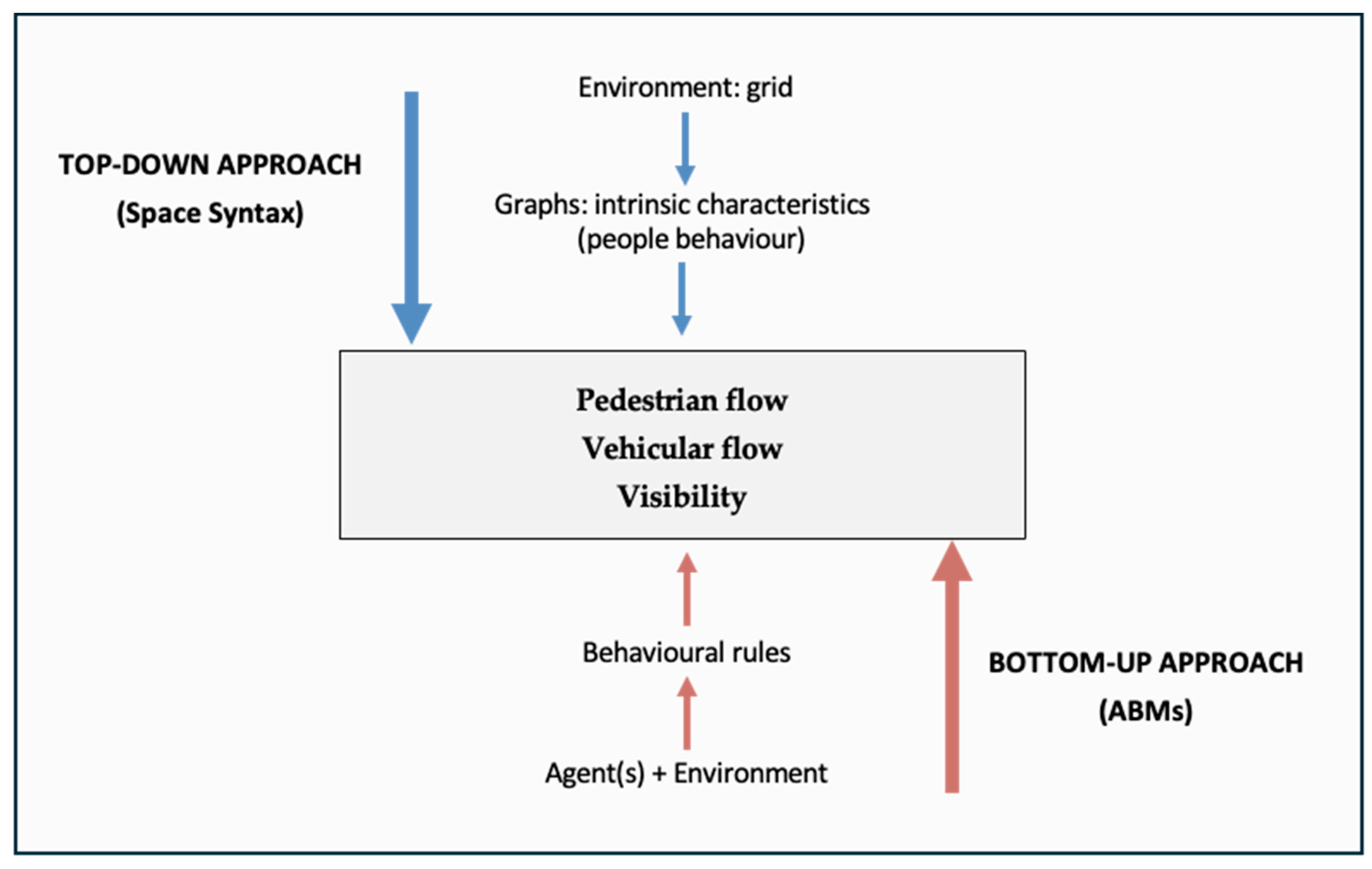
4. Top-Down Modelling Approach

Top-down modelling approaches have a long-standing history in geography, urban planning, and spatial analysis. These models are designed to capture macro-scale urban dynamics by analyzing broad spatial patterns, aggregated data, and global trends, focusing on systemic behaviours and the overall structure of urban environments [40,41]. Such approaches employ significant levels of abstraction and simplification to manage complexity, often utilizing aggregated datasets to identify overarching patterns across urban systems.
The origins of top-down modelling can be traced back to John Snow’s groundbreaking work during the 1854 cholera outbreak in London. By mapping cholera cases and analyzing their spatial distribution, Snow identified contaminated water sources as the root of the epidemic, showcasing the importance of spatial and pattern-based analysis in public health [42]. This foundational example underscores the efficacy of a top-down approach in deriving insights from large-scale spatial data and represents one of the earliest documented uses of spatial modelling in urban research. Over the years, top-down modelling has evolved significantly, particularly with the development of Geographic Information Systems (GISs), which have enhanced the ability to conduct sophisticated analyses of spatial patterns and correlations [43,44]. GIS technology has become integral to top-down modelling, allowing researchers to investigate a range of spatial phenomena and create decision support systems to inform planning and policymaking across various domains, including urban design, transportation planning, environmental management, crime analysis, public health, and disaster response [45,46,47].
Top-down models are particularly effective when applied to systems characterized by a degree of homogeneity, where the behaviour of individual elements can be abstracted to focus on collective trends. This approach works well in scenarios defined by ‘stationary’ conditions—where short-term variability is minimal and interactions among elements are limited or assumed to have a negligible impact on the system’s overall behaviour [6,40,48]. Examples include traffic flow modelling and land use planning, where top-down models identify high-level trends without needing to account for individual agent behaviours, making them ideal for broad spatial analyses that prioritize simplicity and clarity.
The primary advantage of the top-down approach lies in its capacity to provide a macro-level perspective of complex systems. This “big picture” view allows researchers and planners to identify key drivers and critical components, facilitating high-level decision making and prioritization. By abstracting finer details, top-down models simplify analysis and offer a comprehensible framework that is accessible to planners, policymakers, and stakeholders. Additionally, these models are valuable for pinpointing potential system bottlenecks, forecasting long-term trends, and offering insights into broad spatial or temporal patterns [40,41], allowing potential subsequent close-up investigations.
Despite its strengths, top-down modelling has inherent limitations. A significant drawback is its inability to capture micro-level dynamics and emergent phenomena—complex patterns that arise from interactions between individual agents. This emergent behaviour is difficult to model within a top-down framework due to its reliance on aggregated data and static assumptions [6]. Moreover, the top-down approach may overlook the nuanced interactions between individuals and their environment, rendering it less effective for real-time or highly dynamic urban analyses [6,49].
One notable example of a top-down modelling tool is Space Syntax, which will be explored in the following sections through a recognition of its theoretical underpinnings, strengths, limitations, and practical applications, with a particular focus on its relevance for crime dynamics and decision-making processes.

4.1. Extracting Intrinsic Characteristics: The Space Syntax Theory

Space Syntax is a quantitative methodology developed in the early 1980s to study the spatial configuration of urban environments and understand how such layouts influence human behaviour, movement patterns, and social interactions [9,50]. The theory rests on the premise that the spatial structure of a city fundamentally shapes social dynamics, where certain spatial arrangements facilitate or hinder movement and interaction. This relationship between spatial configuration and social outcomes provides urban planners with a powerful analytical tool for assessing and influencing urban spaces.
A core aspect of Space Syntax is its representation of the urban fabric as a network of visual interconnected spaces through the use of sightlines or isovists [51,52]. By breaking down urban environments into nodes and links, Space Syntax—through its theory and extensive set of techniques and measures—enables a systematic analysis of spatial relationships and the extraction of intrinsic information about the environment [9] as well as how people interact within it. These quantitative evaluations are particularly useful for predicting movement patterns and elucidating how spatial configurations influence social behaviour [53].
As a top-down modelling tool, Space Syntax emphasizes the analysis of spatial configurations over variables such as economic activity distribution or individual behavioural traits. This focus is particularly beneficial for examining urban systems at a macro-scale, where large-scale spatial patterns are paramount. The approach has been instrumental in urban design, guiding planners in optimizing layouts to enhance connectivity, accessibility, and social cohesion [9]. Its applications span various domains, including urban planning, transportation studies, and social sciences, providing insights into the spatial determinants of human behaviour [53,54,55].
However, Space Syntax is not without limitations. As it relies primarily on spatial configuration as the main explanatory variable, it can overlook critical socio-economic factors [10], behavioural influences [11,56], temporal dynamics [57], and complexity [58]. Additionally, while abstracting urban environments into simplified graphs is effective for identifying large-scale patterns, it risks oversimplifying the complex interplay of urban dynamics [59,60,61].
The characteristics of Space Syntax underscore its importance in understanding how spatial layouts influence movement and social interactions, aiding planners in optimizing urban design. The following section will delve into specific practical applications of Space Syntax in urban planning, demonstrating its role in improving connectivity, accessibility, and safety in urban environments.

4.2. Space Syntax Impact and Applications in Urban Planning

In the field of urban planning, Space Syntax has proven its utility in analysis and decision support, allowing planners to anticipate the potential impacts of modifications to road networks, public spaces, and building layouts, as well as to understand hidden relationships between different urban phenomena.
With its inherent multiscalarity, Space Syntax has demonstrated effectiveness across various urban scales, from regional and metropolitan levels to micro-urban and local contexts. Its applications are particularly useful for the following:
  • Vehicular flow analysis: At larger scales, Space Syntax helps identify network hierarchies and primary and secondary routes, which are crucial for traffic management and planning. This approach allows planners to design more efficient and resilient transportation systems by detecting potential congestion points and enhancing connectivity [62,63,64]. Insights derived from these analyses can inform strategies to mitigate traffic issues and improve overall network functionality.
  • Risk assessment and emergency planning: Space Syntax can also support risk assessment and emergency planning by cross-referencing flow data with hydrogeological or seismic risk maps, allowing for the categorization of areas based on risk levels. Additionally, this methodology is effective for comparative studies that analyze spatial transformations before and after events, such as natural disasters or urban renovations, to evaluate the impact of these changes on traffic patterns, accessibility, or travel times [65,66].
  • Evolution of urban settlements: By incorporating historical data and reconstructing networks from various periods, Space Syntax supports diachronic analyses of urban settlements [67]. This facilitates the study of evolutionary steps, shifts in centrality, and hidden dynamics, enhancing the depth of analysis of settlement development and transformations over time.
  • Retail distribution analysis: By combining spatial configuration data with additional datasets, Space Syntax models allow planners to understand how urban morphology and spatial configurations influence retail dynamics. This information is valuable for optimizing store placements and designing urban areas that bolster economic sustainability and promote services proximity [68,69,70,71] from the perspective of liveable environments.
  • Pedestrian flow optimization: At smaller urban scales, Space Syntax evaluates spatial configurations to predict pedestrian movement patterns. This type of analysis identifies areas that are naturally visible and surveillable, as well as spaces that are either well integrated or more isolated within the urban network. Such insights are critical for urban design, helping to create safer, more walkable environments that encourage foot traffic and social interaction [72,73].
  • Urban safety enhancement: Space Syntax is also used to enhance urban safety by recommending environmental modifications or optimizing the placement of surveillance systems based on a cost–benefit analysis. By employing axial line maps or visibility graphs and integrating this information with the constitutedness of streets or perceptions of (in)security, planners can prioritize interventions to promote urban safety and liveability [68,74,75,76].
Figure 1 illustrates, in particular, the results of an Angular Segment Analysis (ASA RCL) applied to the road network of Florence, Italy, highlighting the main roads (reddish) over the foreground network (blueish) at a municipal scale, and a Visibility Graph Analysis (VGA) mean depth of the northern part of the historic centre of Pisa, showcasing the most segregated areas (reddish) and more integrated ones (blueish) of the historical centre, related to origin–destination flows. Both of them show the potential of Space Syntax in supporting targeted interventions at different scales.

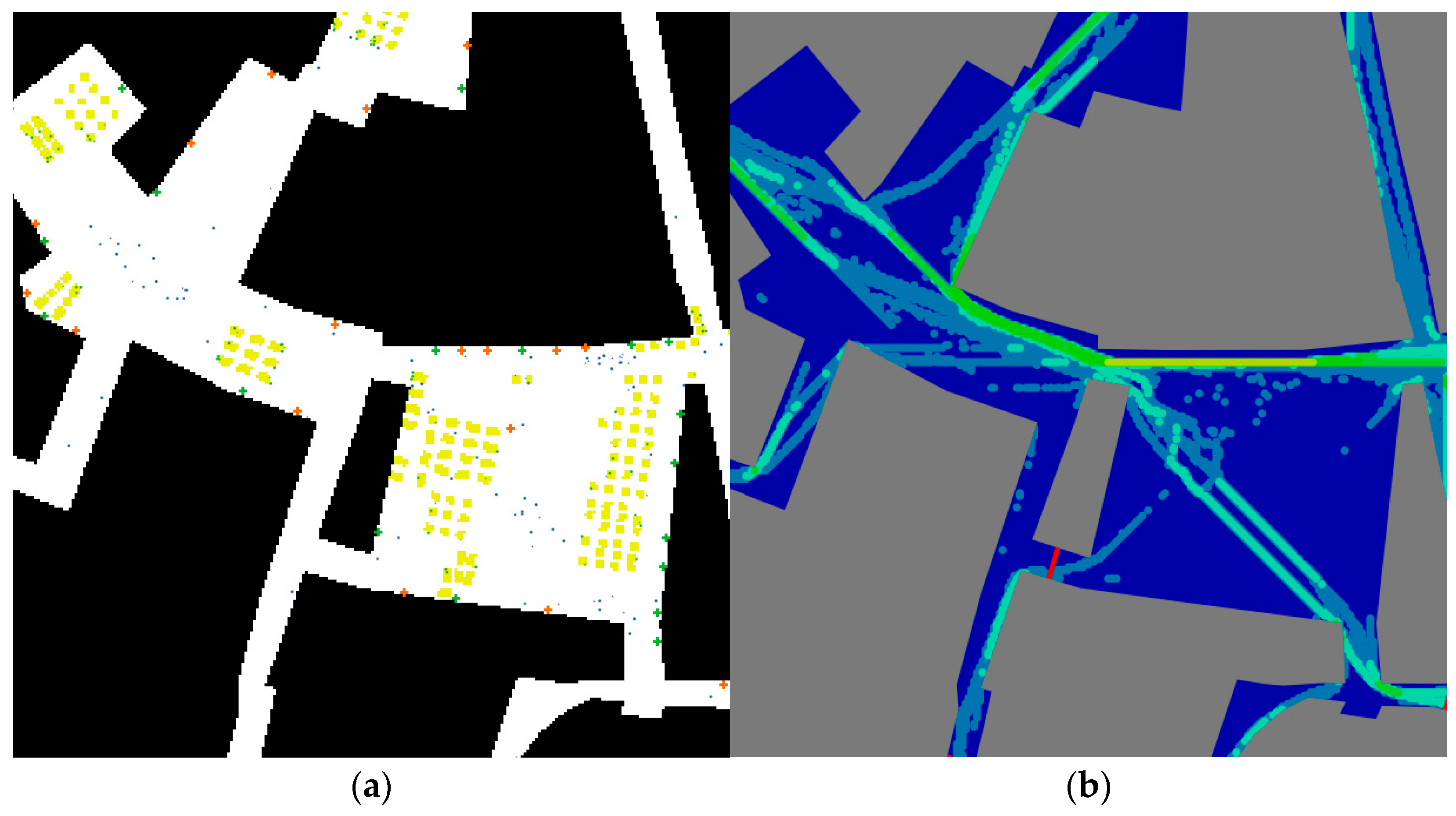
4.3. Space Syntax and Micro-Scale Crime Dynamics

Space Syntax has been extensively applied in crime science since the 1990s, facilitating investigations into the relationships between urban design, crime occurrences, and social behaviour [75,78,79]. Its applicability spans from macro- to micro-urban scales, employing various techniques and metrics that make Space Syntax adaptable for multi-scale investigations with differing levels of granularity. Research has shown correlations between Space Syntax metrics—such as connectivity, integration, and choice—and the incidence of various types of crime [80,81,82]. This body of work underscores the utility of Space Syntax as a tool for interpreting urban social dynamics, particularly in relation to crime [76,83,84].
However, when evaluating crime patterns and crime dynamics, it is crucial to recognize that discussing general crime is not meaningful. Different types of crime follow distinct logics [85]. For example, burglary often occurs in areas with low pedestrian flow, taking advantage of reduced oversight and increased privacy [86,87]. In contrast, pickpocketing thrives in high-flow areas where offenders can blend into crowds and benefit from the copresence of many individuals [88], which decreases visibility and increases the chance of escaping unnoticed. This distinction is essential for accurately interpreting how spatial configurations influence various types of crime.
Mara et al. [76] introduced the concept of spatial crime impedance, building on the idea of spatial impedance inherent in configurational analysis. Spatial crime impedance suggests the existence of an intrinsic spatial characteristic, dictated solely by the configuration of the environment, that can identify areas more or less prone to certain types of crime. This concept aims not to establish simple correlations between space and crime but to explore deeper associations between specific environment-based metrics and crime distribution. It posits that Space Syntax can detect otherwise imperceptible spatial properties that provide valuable clues about environmental aspects facilitating criminal activity.
By defining these spatial characteristics and employing interpretative theories from environmental criminology (see [89,90,91] for a systematic overview), simple models can be constructed to estimate potentially risky areas. This topic will be explored in detail in Section 5 through a close-up investigation comparing Space Syntax and ABM in their ability to extract crime-related metrics.
While Space Syntax proves to be highly effective in understanding crime dynamics, even at micro-scales and with significant granularity, it does have limitations. One notable shortcoming is the lack of a temporal component, which can be particularly significative in exploring crime dynamics. An area’s risk profile can change throughout the day due to factors such as variations in pedestrian traffic or shifts in surveillance levels, as well as depending on many other factors [76]. This temporal inflexibility can impact the interpretation of risk, as areas perceived as safe during one period may become more vulnerable during others.

5. Bottom-Up Modelling Approach

The bottom-up modelling approach is a methodological framework that emphasizes the role of individual-level actions and interactions in shaping larger-scale spatial phenomena. Unlike the top-down approach, which relies on aggregate data and simplified system representations, bottom-up models explore complex systems by simulating the behaviours and decisions of individual agents and observing how these micro-interactions give rise to macro-scale patterns [6]. This approach has become invaluable in geography and urban planning due to its ability to capture intricate human–environment dynamics, social networks, and economic systems, while acknowledging behavioural heterogeneity.
The origins of bottom-up modelling can be traced to microsimulation and spatial interaction models developed between the 1950s and 1970s. Key early contributions include Orcutt’s [92] microsimulation techniques for policy analysis and Tobler’s [93] use of cellular automata (CA) for simulating urban growth and sprawl. Cellular automata gained traction in urban studies due to their simplicity and scalability in modelling spatial processes, further refined by subsequent research [94,95]. The 1990s marked significant progress due to advances in computing power, data storage, and data availability, enabling more sophisticated modelling techniques such as Agent-Based Models (ABMs). ABMs allow multi-scale analysis by integrating individual behaviours as the foundation for understanding emergent, aggregate phenomena [6]. Other notable bottom-up modelling techniques include discrete event simulation (DES) for traffic analysis [96], system dynamics (SD) for evaluating economic or environmental systems [97], and gravity-based spatial interaction models to predict flows like migration and travel demand [98].
Bottom-up approaches are particularly adept at capturing the heterogeneity and diversity of human behaviour. Unlike top-down models, which often generalize behaviours into broad categories, bottom-up models allow for the representation of individual differences, resulting in a more nuanced understanding of spatial processes. This is especially valuable in urban contexts, where diverse interactions among commuters, residents, and tourists can all affect pedestrian flow and congestion in city centres [6,99] or, even more, in exploring micro-scale interactions or social behaviour.
A key advantage of bottom-up models is their ability to simulate emergent phenomena—complex outcomes that arise from interactions at the micro-level but are not predictable by examining individual behaviours alone [100]. Bottom-up modelling enables researchers to observe how simple individual rules can lead to systemic outcomes, and they can provide insights into how micro-scale interactions contribute to macro-scale patterns, making them ideal for scenarios where detailed behavioural data are available [6]. Additionally, these models enable high levels of customization.
Despite their advantages, bottom-up models come with certain challenges. They are often “data-hungry”, requiring detailed, high-quality data on individual agents and their behaviours, which can be both time-consuming and expensive to collect. Lastly, bottom-up models are computationally intensive, especially when large populations or intricate interactions are involved [6,101]. This requirement for significant computational resources has been a barrier to their widespread adoption, though advances in computational power are gradually overcoming these limitations.
Among the various bottom-up modelling tools, Agent-Based Modelling (ABM) stands out as one of the most versatile and widely utilized techniques. ABM represents individuals, or “agents”, as autonomous entities with unique characteristics and behavioural rules, interacting within a simulated environment. These interactions often lead to emergent patterns that mirror real-world phenomena, making ABM especially valuable for studying urban systems, as the following section will explore [6,99].

5.1. Decision-Makers Experiencing the Environment: Agent-Based Modelling

Agent-Based Modelling (ABM) is a computational approach that simulates the actions and interactions of individual agents within a system to explore complex phenomena and emergent behaviours. This method is particularly valuable in fields such as geography and urban planning, where understanding how micro-level decisions shape larger spatial and social patterns is essential [102,103,104]. Each agent in an ABM acts as an autonomous decision-maker with distinct attributes, behaviours, and objectives, enabling the model to capture the complexity of urban systems through dynamic agent interactions and adaptation to their environment.
A defining feature of ABM is its capacity to illustrate the impact of local interactions on broader system dynamics. Unlike top-down models that aggregate behaviour into overarching trends, ABM emphasizes spatial heterogeneity, nonlinear interactions, feedback mechanisms, and complex agent behaviours. This approach is crucial for examining the nuanced dynamics of urban systems, where emergent spatial patterns often result from the diverse actions and interactions of individuals [6]. Due to its flexibility, ABM allows for the inclusion of varied agent attributes and types of interactions, providing a highly granular perspective on how individual actions contribute to emergent spatial patterns.
As a typical bottom-up tool, ABM’s primary strengths lie in its customizability, flexibility, and, like top-down models, its ability to explore alternative scenarios and policy interventions, making it a valuable tool for urban planners and policymakers. By running simulations under various conditions, ABM provides insights into potential outcomes of different strategies.
However, ABM also presents the typical limitations of bottom-up tools: it is computationally demanding, requires extensive datasets to produce accurate results, and depends on theoretical assumptions when designing the environment, agent behaviours, and interactions among agents [73]. Another challenge lies in the calibration and validation of ABMs. Each model’s unique attributes—such as agent behaviour rules, environmental settings, and interaction protocols—complicate the development of standardized design or testing procedures. Although frameworks like the ODD (Overview, Design concepts, and Details) protocol provide guidance, the calibration and validation processes remain complex and requires substantial expertise [48]. This complexity raises concerns about the reliability of ABMs, especially when they are used to inform policy decisions where accuracy is critical [99].
Nevertheless, ABM continues to evolve as a promising method for analyzing and managing urban dynamics. Advances in computational technology, improved data availability, and the development of refined modelling frameworks are progressively addressing many of ABM’s challenges. These improvements are enabling researchers and practitioners to apply ABM to a broader range of urban challenges, which will be further explored in the subsequent section.

5.2. ABM Impact and Applications in Urban Planning

Agent-Based Modelling (ABM) has a wide array of applications in urban planning, providing valuable insights into complex systems where individual decisions collectively influence larger spatial and social patterns. By simulating agents with unique behaviours and observing their interactions over time, ABM allows urban planners to evaluate policy scenarios and make data-driven decisions. The main applications include the following:
  • Traffic flow optimization: ABM helps planners analyze the causes of traffic congestion and explore strategies for improving mobility by simulating the movements of vehicles or pedestrian. For instance, Beuck et al. [105] used ABM to test various traffic management strategies, such as optimizing traffic light timings and adjusting speed limits, to alleviate bottlenecks and enhance overall traffic flow. Similarly, Nagel [106] demonstrated how varying traffic speeds and signal timings can significantly affect congestion, showing that small adjustments at the individual level can lead to citywide improvements in traffic patterns. These applications allow for the simulation of diverse traffic scenarios, supporting the design of more efficient and sustainable urban transportation systems.
  • Land use, urban growth, and environmental planning: ABM is also utilized to model the impacts of land use and urban growth. Parker et al. [107] highlighted, for example, how ABM could simulate land use change based on individual property-owner decisions, revealing the cumulative effects on urban sprawl and land cover transformation. This approach enables planners to visualize the potential outcomes of rezoning or new infrastructure projects on development patterns and resource distribution.
  • Emergency responses: ABM has proven effective for modelling emergency response scenarios, such as disaster evacuations. For example, D’Orazio et al. [108] developed an agent-based model to simulate evacuation behaviours during environmental crises. By representing evacuees as agents with unique behaviours, the model provided insights into evacuation bottlenecks, optimal escape routes, and the efficiency of emergency protocols. These insights are crucial for resilience planning, allowing decision-makers to anticipate and manage sudden large-scale human movements in crisis situations.
  • Social applications and urban liveability: Beyond physical dynamics, ABM is widely applied to study social behaviours in urban settings, particularly at micro-urban scales. ABM can simulate pedestrian movement, crowd dynamics, and visibility within public spaces to assess urban liveability and safety. For instance, Crooks et al. [109] used ABM to analyze pedestrian behaviour and crowd interactions, offering data that help urban designers optimize public spaces for accessibility and comfort. The ability to simulate different design scenarios, such as pedestrian-only zones or street furniture layouts, enhances planners’ capacity to create inviting and functional public environments. Additionally, ABM can integrate environmental factors like pollution monitoring. By linking vehicle movement data with pollution emission rates, models can identify high-risk areas for poor air quality, providing essential input for public health policies and pollution mitigation [110].
  • Public safety: ABM is also used to enhance urban safety by simulating pedestrian movement and visibility to identify high-risk areas for potential criminal activity, as the next section will further explore. This approach can also optimize the placement of surveillance cameras or police patrols, maximizing coverage and deterrence in a cost-effective manner. Unlike static models such as Space Syntax, ABM provides a dynamic perspective that accounts for changes in behaviour over time and under varying conditions (e.g., lighting, weather, weekdays, or weekends) that can impact crime phenomena.
ABM’s versatility lies in its ability to model various agent attributes and interactions, offering a detailed and flexible analysis of how micro-level behaviours contribute to broader spatial phenomena. This is illustrated in Figure 2, where the simulation of pedestrian movement (a) generates flow distribution maps over time as heatmaps (b). This adaptability is particularly relevant in rapidly evolving urban contexts where flexible, adaptive strategies are necessary for sustainable development [6,48]. Researchers and urban planners can now leverage ABM for an expanding range of challenges, including public health interventions, housing market simulations, and comprehensive urban policy testing [6,49,104]. The next section will specifically focus on the use of ABM for crime prevention applications, further illustrating how this bottom-up approach provides critical insights into the spatial and social complexities of urban life.

5.3. ABM and Micro-Scale Crime Dynamics

In the context of urban crime, ABMs simulate dynamic agents representing individuals who interact with each other, perceive their environment, influence one another, and make decisions based on personal needs and changing circumstances, all without centralized control [22,104]. These simulations often result in complex, emergent outcomes derived from simple initial conditions [99]. This feature makes ABM an invaluable tool for understanding crime dynamics at micro-scales, where individual behaviour and interactions play crucial roles in shaping larger patterns.
Unlike the concept of spatial crime impedance used in Space Syntax, ABM emphasizes the agent’s perception of their surroundings, including interactions with other agents and environmental elements. This focus shifts importance from purely spatial properties to the behavioural model underlying agent actions, which determines how they respond to various stimuli. While a deep dive into behavioural modelling extends beyond the scope of this paper, it is essential to acknowledge its impact on the results generated by ABM.
From an interpretative perspective, ABM can be used to investigate crime opportunities by applying theories from environmental criminology. These models facilitate the estimation of metrics related to crime opportunities, such as copresence and surveillability, which will be explored in greater depth in Section 6. By incorporating agents that behave according to criminological principles, ABM can simulate how specific environmental and social factors contribute to the formation of risky areas.
Reflecting the general characteristics of bottom-up approaches, ABMs are highly effective in examining crime dynamics with fine granularity, including temporal variations ([22,111]). This capability allows for the detailed exploration of how crime opportunities change over time [107], considering factors such as peak traffic hours or shifts in environmental lighting. However, the success of ABM relies on carefully calibrated rules governing the environment, the agents’ behaviour, and their interactions [112]. In modelling crime dynamics, even slight variations in agent rules or assumptions can lead to divergent outcomes, necessitating an iterative process with gradual complexity to avoid the “black box” effect [113].
Despite these challenges, ABM has proven capable of estimating certain metrics also identifiable by Space Syntax, albeit through fundamentally different assumptions and processes. This alignment of outputs provides a basis for comparing the two tools. The following section will conduct a close comparative analysis to elucidate the strengths and weaknesses of Space Syntax and ABM in modelling crime dynamics, providing insight into their complementary roles.

6. Discussion: Space Syntax vs. Agent-Based Modelling

At this point, the characteristics and differences between Top-down and Bottom-up approaches have been clearly outlined (Table 2). In particular, Space Syntax and Agent-Based Modelling (ABM) have been closely analyzed as representative tools of both, and previous sections highlighted how they offer distinct yet complementary perspectives on urban modelling, each with its strengths and limitations.
Space Syntax provides insights into movement patterns and social dynamics within urban environments by focusing on the spatial configuration of an area. This method excels at identifying high-traffic areas, evaluating connectivity, and assessing how urban form influences pedestrian flows and social interactions without requiring extensive behavioural data [50]. Space Syntax is particularly useful for static analyses, allowing planners to predict movement trends based solely on spatial layout. However, it lacks the capability to simulate temporal dynamics or to account for emergent behaviours arising from complex, agent-based interactions. Its abstraction into a network of nodes and connections is powerful for assessing spatial relationships but may oversimplify the multifaceted nature of urban life when behavioural or socio-economic variables are essential.
On the other hand, ABM represents a bottom-up approach that simulates the behaviours and interactions of individual agents, allowing for a detailed exploration of emergent phenomena and dynamic processes over time. ABM is particularly effective for modelling scenarios where individual actions contribute significantly to system-wide outcomes, such as pedestrian movement, traffic patterns, and responses to policy changes [6,104]. This approach captures low-level interactions and highlights how micro-scale behaviours aggregate to influence broader spatial and social patterns. However, ABM is data-intensive, requiring detailed information on agent attributes and interactions to yield accurate results. The computational demands of ABM can be significant, and models often require meticulous calibration and validation to ensure reliability [114].
In the existing literature, studies that closely compare top-down and bottom-up modelling approaches in urban planning are rare. While numerous studies analyze or demonstrate the potential of either approach (see [9] for a review of studies on Space Syntax, and [6] for Agent-Based Modelling), comparative analyses or integrations of the two approaches are limited. Notable exceptions include [48,115,116,117,118,119]. Furthermore, many studies address the topic from the perspective of policy strategies instead, often advocating for the integration of top-down and bottom-up planning approaches (e.g., [120,121,122]). However, these discussions fall outside the scope of this paper. In this vein, this paper aims to address the identified gap by providing a close comparison of the different logics and potentialities of these modelling approaches—specifically, Space Syntax (SS) and Agent-Based Modelling (ABM). The objective is to raise awareness among experts and practitioners about the critical importance of developing or selecting appropriate models to better understand urban phenomena and support decision-making processes.
The following section presents a comparative analysis of Space Syntax and ABM as applied to crime dynamics—an exemplary field for exploring their practical deployment. Although environmental approaches to urban security are well represented in the literature, a targeted Scopus search using the keywords “urban” AND ((“bottom-up” OR “bottom up”) OR (“ABM” OR “agent-based”)) AND ((“top-down” OR “top down”) OR (“space syntax”)) AND (“modelling” OR “modeling” OR “digital twin”) AND (“risky area” OR “crime”)—thus representing an expansion of the search illustrated in Section 3—yielded only two relevant sources, of which only one [48] applies a modelling-based approach. This notable scarcity of studies addressing both paradigms in a practical and integrated manner underscores a clear research gap, which this section aims to address through a discussion of the practical—though not yet applied and beyond the scope of this paper—implications of the two modelling approaches in the context of crime dynamics. Accordingly, the analysis focuses on the respective roles of these approaches within environmental criminology, outlining their strengths and limitations in the context of urban crime prevention. This comparison aims to clarify how the two modelling paradigms can be employed—either independently or in combination—to inform more comprehensive urban safety strategies.

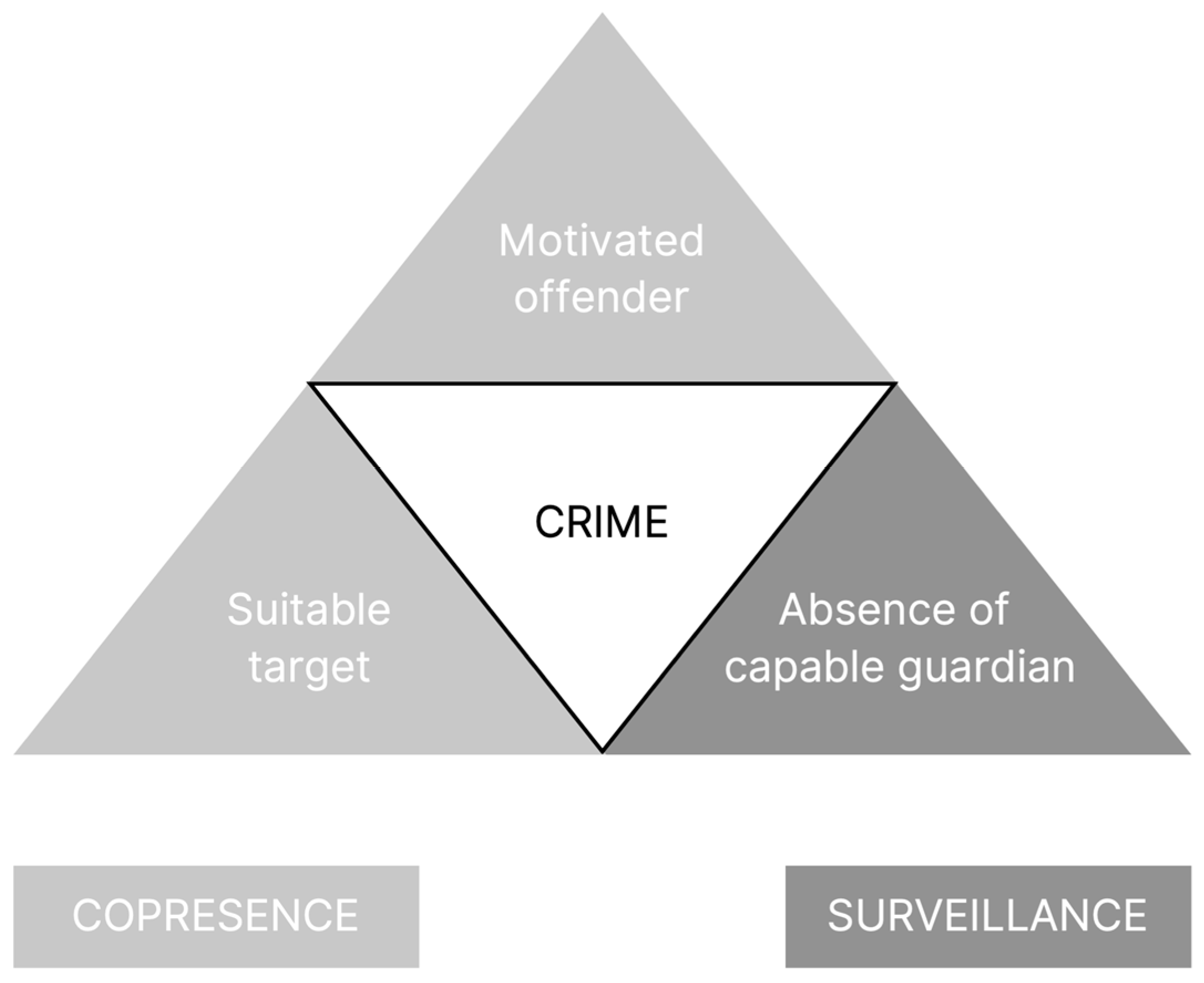
6.1. Challenges in Modelling Crime Dynamics

As discussed in the Introduction, spatial modelling presents significant challenges when applied to road infrastructure analysis or pedestrian movement, underscoring the numerous subsystems that can be included in such models. When it comes to modelling crime dynamics—particularly the relationship between the environment and crime, which is a primary focus in urban planning—the complexity increases, even when the analysis is centred on a specific aspect. This complexity involves understanding the intricate interactions between the physical environment and social behaviours within the context of crime logics [91].
The challenges of modelling crime dynamics are manifold: selecting the appropriate scale of analysis, identifying relevant variables, and accounting for complex interactions and feedback loops. More specifically, questions arise regarding how the environment influences individual behaviour, necessitating robust spatial modelling and the incorporation of behavioural models. This leads to the fundamental question “What influences an individual’s behaviour?”. This question spans multiple disciplines, including sociology, psychology, and criminology, making the development of a comprehensive model particularly challenging.
For the specific purpose of this study, the environmental approach to security can be highly valuable. This approach focuses on the physical and situational characteristics of space that influence crime dynamics and patterns [90]. Within the broad spectrum of environmental criminological theories (see [91]), a specific theoretical framework can be selected to guide modelling choices accordingly. This enables the creation of a simplified representation of reality grounded in well-established criminological frameworks. Depending on the specific research question, modelling requirements will be tailored—such as offender or target perspectives, scale of analysis, granularity, and so forth. Thus, by considering how spatial design and urban configurations affect opportunities for crime, planners and researchers can develop targeted interventions for crime prevention.
The next section will discuss how to construct a ‘good enough’ model to analyze the relationship between space and crime, starting from an environmental criminological framework and selecting the most suitable modelling approach and tool. This exploration aims to show, through a practical example, how model construction is a critical decision that shapes research outcomes and helps identify whether Space Syntax or ABM might be more appropriate for a given objective.

6.2. Unveiling Crime Dynamics at the Micro-Scale: Space Syntax, Agent-Based Modelling, or Both?

To construct a model for understanding crime dynamics, the Rational Choice perspective [123], the Routine Activity Approach [124], and the crime triangle have been adopted as a theoretical framework. This last concept, introduced by Cohen and Felson [124], posits that the conditions for a crime to occur are met when “the convergence in space and time of the three minimal elements of direct-contact predatory violations: (1) motivated offenders; (2) suitable targets; and (3) the absence of capable guardians against a violation” [124], p. 589. This framework, emphasizing the presence of these three elements, can be translated into two core metrics: copresence and surveillance. The simultaneous presence of an offender and a target, alongside the absence of effective surveillance (Figure 3), forms the basis for evaluating crime risk, with these metrics taking on different meanings depending on the type of crime being studied. The question then becomes the following: Is it possible to translate the measures of copresence and surveillance into quantitative metrics? And which of the two approaches is more effective in applying this theoretical model aimed at detecting risky areas?
Space Syntax begins with an analysis of the urban grid and performs graph-based calculations to quantify pedestrian movement and visibility using techniques such as Axial Analysis and Visibility Graph Analysis. These analyses can achieve accuracy levels up to 75% in predicting pedestrian flow [125,126]. Additionally, Space Syntax can hierarchize spaces based on metrics such as visual control and controllability, pinpointing areas that are more observable and identifying vantage points offering comprehensive surveillance of their surroundings [126]. As demonstrated in recent studies [127], VGA can effectively estimate pedestrian flow at a micro-scale, while visual controllability highlights areas’ potential for surveillance, encapsulating what has been termed spatial crime impedance [76]. These spatial metrics, when interpreted within a criminological framework, can create risk indices for crimes such as robbery, pickpocketing, and burglary, guiding strategic interventions. Space Syntax can also evaluate changes in risk indices under different spatial configurations, providing a robust tool for informed urban planning and safety strategies.
Agent-Based Modelling (ABM), on the other hand, simulates agents with unique attributes and behavioural rules, informed by observed data, theories, or contextual variables [48]. ABM can generate pedestrian flows and visibility outcomes akin to those provided by Space Syntax but based on individual behaviour rather than inherent spatial structure. ABM excels at incorporating contextual information, such as commercial activity, social interactions, and environmental conditions like weather, which influence pedestrian behaviour. A major advantage of ABM is its ability to include a temporal component, analyzing how environmental characteristics evolve over time—such as changing light levels and the opening and closing times of businesses—supporting situational interpretations of crime risk [90]. ABM can thus produce dynamic risk maps reflecting both crime types and their temporal aspects, offering predictive insights beyond Space Syntax’s static analysis.
Figure 4 presents a comparison of the key steps and measures provided by Space Syntax (top-down approach) and ABM (bottom-up approach). While Space Syntax relies on graph-based spatial analysis, ABM emerges from the behaviour of individual agents influenced by their interactions and contextual factors.
The question then becomes the following: Which modelling approach is best? The answer, as anticipated, is not straightforward, even after selecting the subsystem and theoretical model underpinning the spatial analysis. Determining the optimal tool depends on various factors:
  • Research question: What specific aspect of crime dynamics is being investigated, and what granularity is expected? Space Syntax is more suitable for analyses that emphasize spatial layout and visibility, while ABM is preferred for studies requiring detailed behavioural modelling and temporal changes.
  • Analysis scale and level of abstraction: Space Syntax is effective for both macro- and micro-level static analyses, leveraging a broad set of techniques. ABM supports dynamic, macro- to micro-level analyses involving complex interactions but requires more detailed agent behaviour modelling.
  • Availability of input data: ABM’s effectiveness depends on detailed input data on agent behaviour and environmental variables, whereas Space Syntax can function with less intensive data requirements.
  • Required accuracy and sensitivity: Depending on the research objectives, one may prioritize a tool that can capture specific behavioural nuances (ABM) or one that offers comprehensive spatial analysis (Space Syntax).
So, again, there is no definitive answer to which tool is superior; the choice is context-dependent. For example, Space Syntax might efficiently highlight high-risk areas based on spatial visibility and connectivity, while ABM can simulate how crime risks change over time and in response to different environmental stimuli. However, it is extremely important to foster a culture of reflection on the model we choose to use or develop for the specific problem we are investigating, before seeking answers.
Moreover, the distinction between top-down and bottom-up approaches is not absolute. Hybrid models that combine elements of both methodologies can offer richer insights. For instance, a model could use Axial Analysis from Space Syntax as an input for ABM simulations or integrate data from Visibility Graph Analysis and Place Syntax [128] to inform agent behaviour. Configurational indices capable of estimating pedestrian flows—such as integration, choice, through vision, point first and second moment [18,53,127]—can provide a solid foundation for driving agent movement in ABM, particularly when enhanced by recent advancements in machine learning-based modelling. Such combinations could leverage Space Syntax’s ability to estimate pedestrian movement as a foundational guide, simplifying the cognitive behavioural model required for agents.
Additionally, appropriate combinations or tailored integrations of Space Syntax and Agent-Based Modelling can help address the respective limitations of each methodology. For instance, incorporating temporally dynamic data—such as diurnal variations in pedestrian flows—or linking models to real-time datasets, as exemplified in recent Place Syntax applications, could mitigate the static nature traditionally associated with Space Syntax. Similarly, advancement in Space Syntax-based ABM [14,117,129,130] (like the ones in Depthmap ambient) may enhance its capacity to represent dynamic urban processes. In parallel, addressing the scalability challenges of agent-based models may require the adoption of alternative data acquisition strategies, including synthetic populations and participatory sensing methods, both of which are increasingly being explored in the literature [131,132,133]. These approaches reduce the high data dependency that often characterizes ABM, making such models more tractable and context-sensitive. This integrated approach has the potential to advance the modelling of urban crime dynamics and support more effective, evidence-based urban planning and design interventions.

7. Conclusions

This study presented a comparative analysis of top-down and bottom-up approaches to spatial and urban modelling, specifically focusing on the applications of Space Syntax and Agent-Based Modelling (ABM). Through this examination, their characteristics, advantages, and limitations, with particular emphasis on their roles in addressing crime dynamics within urban environments, have been highlighted.
Space Syntax, as a top-down approach, demonstrates significant utility in revealing how spatial configurations influence movement and social interactions. Its capacity for conducting multi-scale analyses with a multitude of techniques and metrics has proven valuable for urban planning and crime prevention efforts. The spatial crime impedance has also shown, at least from the theoretical point of view, potential in exploring crime dynamics, which is to be further investigated. However, Space Syntax’s inherent limitation lies in its static nature, which restricts its ability to capture temporal variations and emergent phenomena driven by individual behaviour.
On the other hand, Agent-Based Modelling excels as a bottom-up approach, simulating the behaviour and interactions of individual agents to uncover complex, emergent patterns within urban settings. ABM’s flexibility allows for the inclusion of various contextual and temporal variables, making it highly effective for modelling scenarios where behavioural nuances and dynamic interactions are critical. Nevertheless, its strengths come with challenges, such as high data requirements, intensive computational needs, and the complexity of calibrating agent behaviours.
The main takeaway from this study is the importance of conducting a critical analysis before selecting a modelling approach, emphasizing the alignment of the chosen method with the specific research question and subsystem of interest. The research question itself should guide the selection of initial assumptions, the inclusion or exclusion of components, the scale of analysis, and the type of modelling approach and tool employed. Future developments should conduct a systematic review of different modelling approaches—evaluating topic, purpose, data, scale, granularity, and integration with urban planning tools, thus enabling a more structured and comprehensive comparison of methodologies—and test these approaches across multiple case studies to create more refined guidelines and develop user-friendly, customized tools to be promoted as decision support systems (DSSs) at the municipal level.
Furthermore, although the case study focused on urban crime, the broader contribution of this work lies in demonstrating that, through the construction of an appropriate modelling framework—here grounded in the integration of human behaviour, criminological theories, and modelling metrics—a wide range of urban phenomena can be investigated using either modelling approach, provided that suitable assumptions are made and the research objectives warrant it. Rather than delivering an operational tool for identifying risky areas—an aim beyond the scope of this paper—the practical value of the example is methodological. It underscores the necessity of defining consistent conceptual boundaries and theoretical underpinnings that support the specific modelling strategy. By establishing a shared foundation, this framework facilitates both the comparison and potential integration of top-down and bottom-up approaches across diverse urban contexts, depending on the nature of the data and the research question at hand.
Moreover, a growing recognition of the potential to integrate top-down and bottom-up modelling approaches emerged, indicating that their parallel or combined use could yield a more holistic understanding of urban dynamics. Future studies should explore this integration more thoroughly, focusing on how the structured, spatial insights of Space Syntax could inform agent-based simulations and vice versa. Such models have the potential to significantly enhance urban mobility management and security strategies by capturing both static spatial relationships and dynamic, behavior-driven phenomena, thereby providing effective support to urban planners and policymakers in the design of safer, more resilient, and sustainable cities.

Author Contributions

Conceptualization, F.M. and V.C.; methodology, F.M. and V.C.; software, F.M.; validation, F.M.; investigation, F.M.; data curation, F.M.; writing—original draft preparation, F.M.; writing—review and editing, F.M. and V.C.; visualization, F.M. and V.C.; supervision, V.C. All authors have read and agreed to the published version of the manuscript.

Funding

This research received no external funding.

Conflicts of Interest

The authors declare no conflicts of interest.

References

  1. United Nations. World Urbanization Prospects: The 2018 Revision; Department of Economic and Social Affairs, Population Division: New York, NY, USA, 2019. [Google Scholar]
  2. Batty, M. Fifty years of urban modelling: Macro-statics to micro-dynamics. In The Dynamics of Complex Urban Systems: An Interdisciplinary Approach; Albeverio, S., Andrey, D., Giordano, P., Vancheri, A., Eds.; Physica-Verlag: Heidelberg, Germany, 2008; pp. 1–20. [Google Scholar]
  3. Bettencourt, L.M. The origins of scaling in cities. Science 2013, 340, 1438–1441. [Google Scholar] [CrossRef]
  4. Batty, M. Digital twins. Environ. Plan. B Urban Anal. City Sci. 2018, 45, 817–820. [Google Scholar] [CrossRef]
  5. Scolozzi, R.; Poli, R. System dynamics education: Becoming part of anticipatory systems. Horizon 2015, 23, 107–118. [Google Scholar] [CrossRef]
  6. Crooks, A.; Malleson, N.; Manley, E.; Heppenstall, A. Agent-Based Modelling and Geographical Information Systems: A Practical Primer; Sage: Thousand Oaks, CA, USA, 2018. [Google Scholar]
  7. Cunha, N.S.; Magalhães, M.R.; Domingos, T.; Abreu, M.M.; Küpfer, C. The land morphology approach to flood risk mapping: An application to Portugal. J. Environ. Manag. 2017, 193, 172–187. [Google Scholar] [CrossRef] [PubMed]
  8. Rak, J.; Girão-Silva, R.; Gomes, T.; Ellinas, G.; Kantarci, B.; Tornatore, M. Disaster resilience of optical networks: State of the art, challenges, and opportunities. Opt. Switch. Netw. 2021, 42, 100619. [Google Scholar] [CrossRef]
  9. Van Nes, A.; Yamu, C. Introduction to Space Syntax in Urban Studies; Springer Nature: Cham, Switzerland, 2021; p. 250. [Google Scholar]
  10. Gehl, J. Cities for People; Island Press: Washington, DC, USA, 2010. [Google Scholar]
  11. Jacobs, J. The Death and Life of Great American Cities; Random House: New York, NY, USA, 1961. [Google Scholar]
  12. Shaaban, K.; Shakeel, K.; Rashidi, T.H.; Kim, I. Measuring users’ satisfaction of the road network using structural equation modeling. Int. J. Sustain. Transp. 2022, 16, 792–803. [Google Scholar] [CrossRef]
  13. Bellini, D. Provided and perceived quality for performance-based road management: A comparison model. In Choice for Sustainable Development, Pre-Proceedings of the 23rd PIARC World Road Congress; World Road Association (PIARC): Paris, France, 2007. [Google Scholar]
  14. Penn, A.; Turner, A. Space syntax-based agent simulation. In Pedestrian and Evacuation Dynamics; Springer: Berlin/Heidelberg, Germany, 2002. [Google Scholar]
  15. Helbing, D.; Molnár, P.; Farkas, I.J.; Bolay, K. Self-organizing pedestrian movement. Environ. Plan. B Plan. Des. 2001, 28, 361–383. [Google Scholar] [CrossRef]
  16. Turner, A. Could a road-centre line be an axial line in disguise. In Proceedings of the 5th International Symposium on Space Syntax, Delft, The Netherlands, 13–17 June 2005; Volume 1, pp. 145–159. [Google Scholar]
  17. Snyder, H. Literature review as a research methodology: An overview and guidelines. J. Bus. Res. 2019, 104, 333–339. [Google Scholar] [CrossRef]
  18. Yamu, C.; Van Nes, A.; Garau, C. Bill Hillier’s legacy: Space syntax—A synopsis of basic concepts, measures, and empirical application. Sustainability 2021, 13, 3394. [Google Scholar] [CrossRef]
  19. Sharmin, S.; Kamruzzaman, M. Meta-analysis of the relationships between space syntax measures and pedestrian movement. Transp. Rev. 2018, 38, 524–550. [Google Scholar] [CrossRef]
  20. Barbati, M.; Bruno, G.; Genovese, A. Applications of agent-based models for optimization problems: A literature review. Expert Syst. Appl. 2012, 39, 6020–6028. [Google Scholar] [CrossRef]
  21. Abar, S.; Theodoropoulos, G.K.; Lemarinier, P.; O’Hare, G.M. Agent-based modelling and simulation tools: A review of the state-of-art software. Comput. Sci. Rev. 2017, 24, 13–33. [Google Scholar] [CrossRef]
  22. Groff, E.R.; Johnson, S.D.; Thornton, A. State of the art in agent-based modeling of urban crime: An overview. J. Quant. Criminol. 2019, 35, 155–193. [Google Scholar] [CrossRef]
  23. Wan, L.; Nochta, T.; Tang, J.; Schooling, J. (Eds.) Digital Twins for Smart Cities: Conceptualisation, Challenges and Practices; ICE Publishing: London, UK, 2023. [Google Scholar]
  24. Nag, D.; Brandel-Tanis, F.; Pramestri, Z.A.; Pitera, K.; Frøyen, Y.K. Exploring digital twins for transport planning: A review. Eur. Transp. Res. Rev. 2025, 17, 15. [Google Scholar] [CrossRef]
  25. Adinkrah, J.; Kemausuor, F.; Tchao, E.T.; Nunoo-Mensah, H.; Agbemenu, A.S.; Adu-Poku, A.; Kponyo, J.J. Artificial intelligence-based strategies for sustainable energy planning and electricity demand estimation: A systematic review. Renew. Sustain. Energy Rev. 2025, 210, 115161. [Google Scholar] [CrossRef]
  26. Wang, J.; Li, G.; Lu, H.; Wu, Z. Urban models: Progress and perspective. Sustain. Futures 2024, 7, 100181. [Google Scholar] [CrossRef]
  27. Hu, M.; Ghorbany, S. Building stock models for embodied carbon emissions—A review of a nascent field. Sustainability 2024, 16, 2089. [Google Scholar] [CrossRef]
  28. Guo, Y.; Shi, J.; Guo, T.; Guo, F.; Lu, F.; Su, L. Grey-Box Method for Urban Building Energy Modelling: Advancements and Potentials. Energies 2024, 17, 5463. [Google Scholar] [CrossRef]
  29. Kong, D.; Cheshmehzangi, A.; Zhang, Z.; Ardakani, S.P.; Gu, T. Urban building energy modeling (UBEM): A systematic review of challenges and opportunities. Energy Effic. 2023, 16, 69. [Google Scholar] [CrossRef]
  30. Pielke, R.A., Sr.; Adegoke, J.; Hossain, F.; Niyogi, D. Environmental and social risks to biodiversity and ecosystem health—A bottom-up, resource-focused assessment framework. Earth 2021, 2, 440–456. [Google Scholar] [CrossRef]
  31. Nochta, T.; Wahby, N.; Schooling, J.M. Knowledge politics in the smart city: A case study of strategic urban planning in Cambridge, UK. Data Policy 2021, 3, e31. [Google Scholar] [CrossRef]
  32. Ali, U.; Shamsi, M.H.; Hoare, C.; Mangina, E.; O’Donnell, J. Review of urban building energy modeling (UBEM) approaches, methods and tools using qualitative and quantitative analysis. Energy Build. 2021, 246, 111073. [Google Scholar] [CrossRef]
  33. Li, W.; Zhou, Y.; Cetin, K.; Eom, J.; Wang, Y.; Chen, G.; Zhang, X. Modeling urban building energy use: A review of modeling approaches and procedures. Energy 2017, 141, 2445–2457. [Google Scholar] [CrossRef]
  34. Lim, H.; Zhai, Z.J. Review on stochastic modeling methods for building stock energy prediction. In Building Simulation; Tsinghua University Press: Beijing, China, 2017; Volume 10, pp. 607–624. [Google Scholar]
  35. Gentner, D.R.; Jathar, S.H.; Gordon, T.D.; Bahreini, R.; Day, D.A.; El Haddad, I.; Hayes, P.L.; Pieber, S.M.; Platt, S.M.; de Gouw, J.; et al. Review of urban secondary organic aerosol formation from gasoline and diesel motor vehicle emissions. Environ. Sci. Technol. 2017, 51, 1074–1093. [Google Scholar] [CrossRef]
  36. Li, S.; Liu, X.; Li, X.; Chen, Y. Simulation model of land use dynamics and application: Progress and prospects. J. Remote Sens. 2021, 21, 329–340. [Google Scholar] [CrossRef]
  37. Chen, S.; Chen, B.; Fath, B.D. Urban ecosystem modeling and global change: Potential for rational urban management and emissions mitigation. Environ. Pollut. 2014, 190, 139–149. [Google Scholar] [CrossRef] [PubMed]
  38. Santese, F.E.; Di Sabatino, S.; Solazzo, E.F.; Britter, R. Modelling urban heat island in the context of a Mediterranean city. Dev. Environ. Sci. 2007, 6, 55–63. [Google Scholar]
  39. Stern, R.; Yamartino, R.J.; Graff, A. Analyzing the response of a chemical transport model to emissions reductions utilizing various grid resolutions. Dev. Environ. Sci. 2007, 6, 467–478. [Google Scholar]
  40. Batty, M. The New Science of Cities; MIT Press: Cambridge, MA, USA, 2013. [Google Scholar]
  41. Longley, P.A.; Goodchild, M.F.; Maguire, D.J.; Rhind, D.W. Geographical Information Systems and Science, 2nd ed.; John Wiley & Sons: Hoboken, NJ, USA, 2005. [Google Scholar]
  42. Snow, J. Cholera and the water supply in the south districts of London in 1854. J. Public Health Sanit. Rev. 1856, 2, 239–257. [Google Scholar]
  43. Lombardini, G. Dealing with resilience conceptualisation. Formal ontologies as a tool for implementation of intelligent geographic information systems. TeMA-J. Land Use Mobil. Environ. 2014, 633–644. [Google Scholar] [CrossRef]
  44. Murgante, B.; Borruso, G.; Lapucci, A. Sustainable development: Concepts and methods for its application in urban and environmental planning. In Geocomputation, Sustainability, and Environmental Planning; Springer: Berlin/Heidelberg, Germany, 2011; pp. 1–15. [Google Scholar]
  45. Cova, T.J. GIS in emergency management. In Encyclopedia of Information Systems; Academic Press: Cambridge, MA, USA, 2003; pp. 635–643. [Google Scholar]
  46. Chainey, S.; Ratcliffe, J. GIS and Crime Mapping; John Wiley & Sons: Chichester, UK, 2005. [Google Scholar]
  47. Cromley, E.K.; McLafferty, S.L. GIS and Public Health, 2nd ed.; Guilford Press: New York, NY, USA, 2012. [Google Scholar]
  48. Mara, F.; Altafini, D.; Cutini, V.; Malleson, N. Simulation to forecast crime patterns: Comparing space syntax and agent-based models in exploring pedestrian movement and visibility. Environ. Plan. B Urban Anal. City Sci. 2024, 23998083251324065. [Google Scholar] [CrossRef]
  49. Esposito, D.; Santoro, S.; Camarda, D. Agent-based analysis of urban spaces using space syntax and spatial cognition approaches: A case study in Bari, Italy. Sustainability 2020, 12, 4625. [Google Scholar] [CrossRef]
  50. Hillier, B.; Hanson, J. The Social Logic of Space; Cambridge University Press: Cambridge, UK, 1984. [Google Scholar]
  51. Turner, A.; Doxa, M.; O’Sullivan, D.; Penn, A. From isovists to visibility graphs: A methodology for the analysis of architectural space. Environ. Plan. B Plan. Des. 2001, 28, 103–121. [Google Scholar] [CrossRef]
  52. Mara, F.; Cutini, V. Digital city-surveillance models and urban security: Integrating isovist and space syntax in realising adaptive decision support systems. In International Conference on Computational Science and Its Applications; Springer International Publishing: Cham, Switzerland, 2022; pp. 353–369. [Google Scholar]
  53. Hillier, B.; Penn, A.; Hanson, J.; Grajewski, T.; Xu, J. Natural movement: Or, configuration and attraction in urban pedestrian movement. Environ. Plan. B Plan. Des. 1993, 20, 29–66. [Google Scholar] [CrossRef]
  54. Penn, A.; Hillier, B.; Banister, D.; Xu, J. Configurational modelling of urban movement networks. Environ. Plan. B Plan. Des. 1998, 25, 59–84. [Google Scholar] [CrossRef]
  55. Altafini, D.; Musolino, D.; da Costa Braga, A.; Cutini, V. Spatial configuration and the Messina Strait question: A discussion on Reggio-Calabria and Messina road-networks linkage. Appl. Geogr. 2022, 146, 102750. [Google Scholar] [CrossRef]
  56. Goffman, E. The Presentation of Self in Everyday Life; University of Edinburgh Social Sciences Research Centre: Edinburgh, UK, 1959. [Google Scholar]
  57. Hägerstrand, T. What about people in regional science? Pap. Reg. Sci. 1970, 24, 7–21. [Google Scholar] [CrossRef]
  58. Talen, E. The social goals of new urbanism. J. Urban Des. 2000, 5, 211–230. [Google Scholar] [CrossRef]
  59. Rattenbury, K.; Tschumi, B. The complexity of urban space: A critique of space syntax. Archit. Des. 2006, 76, 54–61. [Google Scholar]
  60. Salingaros, N.A. Space syntax: A critical review. J. Urban Des. 2005, 10, 329–348. [Google Scholar]
  61. Kragh, J. The limits of space syntax: A case study of the urban environment. J. Urban. Int. Res. Placemaking Urban Sustain. 2010, 3, 1–20. [Google Scholar]
  62. Cutini, V. La Rivincita dello Spazio Urbano: L’approccio Configurazionale all’ Analisi e allo Studio dei Centri Abitati; Plus: Dublin, Ireland, 2010. [Google Scholar]
  63. Paul, S. Understanding the influence of roadway configuration on traffic flows through a conventional traffic-assignment model. J. Transp. Lit. 2015, 9, 40–44. [Google Scholar] [CrossRef]
  64. Johnsson, M.; Camporeale, C. Exploring space syntax integration at public transport hubs and public squares using drone footage. Appl. Sci. 2022, 12, 6515. [Google Scholar] [CrossRef]
  65. Pezzica, C.; Valerio, C.; Bleil De Souza, C. Rapid configurational analysis using OSM data: Towards the use of space syntax to orient post-disaster decision making. In Proceedings of the 12th Space Syntax Symposium, Beijing, China, 8–13 July 2019. [Google Scholar]
  66. Tsai, Y.; Chang, Y. Contribution of accessibility to urban resilience and evacuation planning using spatial analysis. Int. J. Environ. Res. Public Health 2023, 20, 2913. [Google Scholar] [CrossRef]
  67. Griffiths, S. The use of space syntax in historical research: Current practice and future possibilities. In Proceedings of the Eighth International Space Syntax Symposium, Santiago, Chile, 3–6 January 2012; Volume 8, pp. 1–26. [Google Scholar]
  68. Yamu, C.; Garau, C. The 15-min city: A configurational approach for understanding the spatial, economic, and cognitive context of walkability in Vienna. In International Conference on Computational Science and Its Applications; Springer International Publishing: Cham, Switzerland, 2022; pp. 387–404. [Google Scholar]
  69. Annunziata, A.; Desogus, G.; Mighela, F.; Garau, C. Health and mobility in the post-pandemic scenario: An analysis of the adaptation of sustainable urban mobility plans in key contexts of Italy. In International Conference on Computational Science and Its Applications; Springer International Publishing: Cham, Switzerland, 2022; pp. 439–456. [Google Scholar]
  70. Murgante, B.; Valluzzi, R.; Annunziata, A. Developing a 15-minute city: Evaluating urban quality using configurational analysis. The case study of Terni and Matera, Italy. Appl. Geogr. 2024, 162, 103171. [Google Scholar] [CrossRef]
  71. Adebayo, A.A.; Greenhalgh, P.; Muldoon-Smith, K.; Oyedokun, T. Towards attaining sustainable retail property locations: The relationships between supply, demand, and accessibility of retail spaces. Sustainability 2022, 14, 3846. [Google Scholar] [CrossRef]
  72. Hacar, Ö.Ö.; Gülgen, F.; Bilgi, S. Evaluation of the space syntax measures affecting pedestrian density through ordinal logistic regression analysis. ISPRS Int. J. Geo-Inf. 2020, 9, 589. [Google Scholar] [CrossRef]
  73. Mara, F. Urban Design and Crime Prevention: Towards an Environmental Approach to Security. Ph.D. Thesis, University of Pisa, Pisa, Italy, 31 March 2024. [Google Scholar]
  74. Van Nes, A.; López, M.J. Micro scale spatial relationships in urban studies: The relationship between private and public space and its impact on street life. In Proceedings of the 6th Space Syntax Symposium (6SSS), Istanbul, Turkey, 12–15 June 2007. [Google Scholar]
  75. Van Nes, A.; López, M.J. Macro and micro scale spatial variables and the distribution of residential burglaries and theft from cars: An investigation of space and crime in the Dutch cities of Alkmaar and Gouda. J. Space Syntax. 2010, 1, 314. [Google Scholar]
  76. Mara, F.; Hacar, Ö.Ö.; Hacar, M.; Altafini, D.; Valerio, C. Exploring Spatial Crime Impedance to Highlight Risky Places: A Space Syntax-Based Environmental Approach to Urban Security. 2024. Available online: https://www.researchgate.net/publication/382002087_Exploring_Spatial_Crime_Impedance_to_highlight_risky_places_A_Space_Syntax-based_environmental_approach_to_urban_security (accessed on 22 April 2025).
  77. Cutini, V. La Forma del Disordine: Tecniche di Analisi e Progetto Urbano ai Tempi Dello Sprawl; Mimesis Edizioni: Sesto San Giovanni, Italy, 2016; pp. 1–226. [Google Scholar]
  78. Hillier, B.; Shu, S. Crime and Urban Layout: The Need for Evidence. 2000. Available online: https://www.semanticscholar.org/paper/Crime-and-urban-layout%3A-the-need-for-evidence-Hillier-Shu/5ff60f19c163eee17b3b6ab7ea8f32a795c7cfa1 (accessed on 22 April 2025).
  79. Hillier, B.; Sahbaz, O. An Evidence-Based Approach to Crime and Urban Design, or, Can We Have Vitality, Sustainability, and Security All at Once? Bartlett School of Graduates Studies, University College London: London, UK, 2008; pp. 1–28. Available online: https://spacesyntax.com/wp-content/uploads/2011/11/Hillier-Sahbaz_An-evidence-based-approach_010408.pdf (accessed on 22 April 2025).
  80. Summers, L.; Johnson, S.D. Does the configuration of the street network influence where outdoor serious violence takes place? Using space syntax to test crime pattern theory. J. Quant. Criminol. 2017, 33, 397–420. [Google Scholar] [CrossRef]
  81. Nubani, L.; Wineman, J. The role of space syntax in identifying the relationship between space and crime. In Proceedings of the 5th Space Syntax Symposium, Delft, The Netherlands, 13–17 June 2005; pp. 13–17. [Google Scholar]
  82. Lopez, M.; Van Nes, A. Space and crime in Dutch built environments. In Proceedings of the 6th International Space Syntax Symposium, Istanbul, Turkey, 12–15 June 2007. [Google Scholar]
  83. Hillier, B.; Sahbaz, O. Safety in numbers: High-resolution analysis of crime in street networks. In The Urban Fabric of Crime and Fear; Springer: Dordrecht, The Netherlands, 2012; pp. 111–137. [Google Scholar]
  84. Van Nes, A.; Lopez, M.; de Bonth, L.; Verhagen, D.; Waaijer, S. Spatial tools for diagnosing the degree of safety and liveability, and to regenerate urban areas in the Netherlands. Res. Urban. Ser. 2016, 4, 139–156. [Google Scholar]
  85. Linning, S.J.; Andresen, M.A.; Brantingham, P.J. Crime seasonality: Examining the temporal fluctuations of property crime in cities with varying climates. Int. J. Offender Ther. Comp. Criminol. 2016, 61, 1866–1891. [Google Scholar] [CrossRef] [PubMed]
  86. Montoya, L.; Junger, M.; Ongena, Y. The relation between residential property and its surroundings and day-and night-time residential burglary. Environ. Behav. 2016, 48, 515–549. [Google Scholar] [CrossRef]
  87. Hoppe, T.; Gerell, M. Near-repeat burglary patterns in Malmö: Stability and change over time. Eur. J. Criminol. 2018, 16, 3–17. [Google Scholar] [CrossRef]
  88. Young, L. The ‘place’ of street children in Kampala, Uganda: Marginalisation, resistance, and acceptance in the urban environment. Environ. Plan. D Soc. Space 2003, 21, 385–401. [Google Scholar] [CrossRef]
  89. Cozens, P.; Love, T. A review and current status of crime prevention through environmental design (CPTED). J. Plan. Lit. 2015, 30, 393–412. [Google Scholar] [CrossRef]
  90. Wortley, R.; Townsley, M. Environmental Criminology and Crime Analysis, 2nd ed.; Routledge: Abingdon, UK, 2017. [Google Scholar]
  91. Mara, F.; Cutini, V. The environmental approach to security: A historical-theoretical literature review on space and crime. Plan. Theory Pract. 2024, 25, 525–547. [Google Scholar] [CrossRef]
  92. Orcutt, G.H. A new type of socio-economic system. Rev. Econ. Stat. 1957, 39, 116–123. [Google Scholar] [CrossRef]
  93. Tobler, W.R. Cellular geography. In Philosophy in Geography; Gale, S., Olsson, G., Eds.; Reidel: Dordrecht, The Netherlands, 1979; pp. 379–386. [Google Scholar]
  94. Al-Ahmadi, K.; See, L.; Heppenstall, A.; Hogg, J. Calibration of a fuzzy cellular automata model of urban dynamics in Arabia. Ecol. Complex. 2009, 6, 80–101. [Google Scholar] [CrossRef]
  95. Cioffi-Revilla, C. Introduction to Computational Social Science: Principles and Applications; Springer: New York, NY, USA, 2014. [Google Scholar]
  96. Espinosa-Aranda, J.L.; García-Ródenas, R. A discrete event-based simulation model for real-time traffic management in railways. J. Intell. Transp. Syst. 2012, 16, 94–107. [Google Scholar] [CrossRef]
  97. Forrester, J.W. Urban Dynamics; MIT Press: Cambridge, MA, USA, 1969. [Google Scholar]
  98. Dennett, A.; Wilson, A. A multilevel spatial interaction modelling framework for estimating interregional migration in Europe. Environ. Plan. A 2013, 44, 1491–1507. [Google Scholar] [CrossRef]
  99. Gilbert, N.; Troitzsch, K.G. Simulation for the Social Scientist, 2nd ed.; Open University Press: Maidenhead, UK, 2005. [Google Scholar]
  100. Hoel, E.P.; Albantakis, L.; Tononi, G. Quantifying causal emergence shows that macro can beat micro. Proc. Natl. Acad. Sci. USA 2013, 110, 19790–19795. [Google Scholar] [CrossRef] [PubMed]
  101. Kumar, A. Multiagent decision making and learning in urban environments. In Proceedings of the Twenty-Eighth International Joint Conference on Artificial Intelligence, Macao, China, 10–16 August 2019; pp. 6398–6402. [Google Scholar] [CrossRef]
  102. Axelrod, R. The Complexity of Cooperation: Agent-Based Models of Competition and Collaboration; Princeton University Press: Princeton, NJ, USA, 1997. [Google Scholar]
  103. Esposito, D.; Abbattista, I.; Camarda, D. A conceptual framework for agent-based modeling of human behavior in spatial design. In Agents and Multi-Agent Systems: Technologies and Applications 2020, Proceedings of the 14th KES International Conference, KES-AMSTA, Split, Croatia, 17–19 June 2020; Springer: Singapore, 2020; pp. 187–198. [Google Scholar]
  104. Bonabeau, E. Agent-based modelling: Methods and techniques for simulating human systems. Proc. Natl. Acad. Sci. USA 2002, 99, 7280–7287. [Google Scholar] [CrossRef]
  105. Beuck, U.; Rieser, M.; Strippgen, D.; Balmer, M.; Nagel, K. Preliminary results of a multi-agent traffic simulation for Berlin. In The Dynamics of Complex Urban Systems, Albeverio, S., Ed.; Physica-Verlag: Heidelberg, Germany, 2008; pp. 75–94. [Google Scholar]
  106. Nagel, K. Traffic networks. In Handbook of Graphs and Networks: From the Genome to the Internet; Bornholdt, S., Schuster, H., Eds.; Wiley-VCH: Weinheim, Germany, 2003; pp. 248–272. [Google Scholar]
  107. Parker, D.C.; Manson, S.M.; Janssen, M.A.; Hoffmann, M.J.; Deadman, P. Multi-agent systems for the simulation of land-use and land-cover change: A review. Ann. Assoc. Am. Geogr. 2003, 93, 314–337. [Google Scholar] [CrossRef]
  108. D’Orazio, M.; Spalazzi, L.; Quagliarini, E.; Bernardini, G. Agent-based model for earthquake pedestrians’ evacuation in urban outdoor scenarios: Behavioural patterns definition and evacuation paths choice. Saf. Sci. 2014, 62, 450–465. [Google Scholar] [CrossRef]
  109. Crooks, A.; Croitoru, A.; Lu, X.; Wise, S.; Irvine, J.M.; Stefanidis, A. Walk this way: Improving pedestrian agent-based models through scene activity analysis. ISPRS Int. J. Geo-Inf. 2015, 4, 1627–1656. [Google Scholar] [CrossRef]
  110. Orii, L.; Alonso, L.; Larson, K. Methodology for establishing well-being urban indicators at the district level to be used on the CityScope platform. Sustainability 2020, 12, 9458. [Google Scholar] [CrossRef]
  111. Weisburd, D.; Braga, A.A.; Groff, E.R.; Wooditch, A. Can hot spots policing reduce crime in urban areas? An agent-based simulation. Criminology 2017, 55, 137–173. [Google Scholar] [CrossRef]
  112. Malleson, N.; Heppenstall, A.; See, L.; Evans, A. Using an agent-based crime simulation to predict the effects of urban regeneration on individual household burglary risk. Environ. Plan. B Plan. Des. 2013, 40, 405–426. [Google Scholar] [CrossRef]
  113. Dyer, J.; Cannon, P.; Farmer, J.D.; Schmon, S.M. Black-box Bayesian inference for agent-based models. J. Econ. Dyn. Control 2024, 161, 104827. [Google Scholar] [CrossRef]
  114. Heppenstall, A.J.; Crooks, A.T.; Batty, M.; See, L.M. Reflections and conclusions: Geographical models to address grand challenges. In Agent-Based Models of Geographical Systems; Springer: Berlin/Heidelberg, Germany, 2012; pp. 739–747. [Google Scholar]
  115. Castella, J.C.; Kam, S.P.; Quang, D.D.; Verburg, P.H.; Hoanh, C.T. Combining top-down and bottom-up modelling approaches of land use/cover change to support public policies: Application to sustainable management of natural resources in northern Vietnam. Land Use Policy 2007, 24, 531–545. [Google Scholar] [CrossRef]
  116. Li, W.; Wu, C.; Zang, S. Modeling urban land use conversion of Daqing City, China: A comparative analysis of “top-down” and “bottom-up” approaches. Stoch. Environ. Res. Risk Assess. 2014, 28, 817–828. [Google Scholar] [CrossRef]
  117. Omer, I.; Kaplan, N. Using space syntax and agent-based approaches for modeling pedestrian volume at the urban scale. Comput. Environ. Urban Syst. 2017, 64, 57–67. [Google Scholar] [CrossRef]
  118. Riu, S.Y.; Kim, J.Y.; Kim, Y.O. Improvements of space syntax based agent simulation for analysing crowd movement. In Proceedings of the 14th International Space Syntax Symposium, Nicosia, Cyprus, 24–28 June 2024. [Google Scholar]
  119. Kim, J.Y.; Kim, Y.O. Analysis of pedestrian behaviors in subway stations using agent-based model: Case of Gangnam Station, Seoul, Korea. Buildings 2023, 13, 537. [Google Scholar] [CrossRef]
  120. Semeraro, T.; Zaccarelli, N.; Lara, A.; Sergi Cucinelli, F.; Aretano, R. A bottom-up and top-down participatory approach to planning and designing local urban development: Evidence from an urban university center. Land 2020, 9, 98. [Google Scholar] [CrossRef]
  121. Pissourios, I. Top-down and bottom-up urban and regional planning: Towards a framework for the use of planning standards. Eur. Spat. Res. Policy 2014, 21, 83–99. [Google Scholar] [CrossRef]
  122. Breuer, J.; Walravens, N.; Ballon, P. Beyond defining the smart city: Meeting top-down and bottom-up approaches in the middle. TeMA-J. Land Use Mobil. Environ. 2014, 153–164. [Google Scholar] [CrossRef]
  123. Clarke, R.V.; Cornish, D.B. Modeling offenders’ decisions: A framework for research and policy. In Crime Opportunity Theories; Routledge: Oxfordshire, UK, 2017; pp. 157–195. [Google Scholar]
  124. Cohen, L.; Felson, M. Social change and crime rate trends: A routine activity approach. Am. Sociol. Rev. 1979, 44, 588–608. [Google Scholar] [CrossRef]
  125. Lerman, Y.; Rofè, Y.; Omer, I. Using space syntax to model pedestrian movement in urban transportation planning. Geogr. Anal. 2014, 45, 392–410. [Google Scholar] [CrossRef]
  126. Mara, F.; Altafini, D.; Cutini, V. Urban design, space syntax and crime: An evidence-based approach to evaluate urban crime geographical displacement and surveillance efficiency. In Proceedings of the 13th International Space Syntax Symposium, Bergen, Norway, 20–24 June 2022. [Google Scholar]
  127. Mara, F.; Öztürk Hacar, O.; Gülgen, F.; Altafini, D. Interpreting the configuration of micro-urban environments: Line-based analyses vs. visibility graph analyses for estimating pedestrian flows. In Proceedings of the 14th International Symposium on Space Syntax, Nicosia, Cyprus, 24–28 June 2024. [Google Scholar]
  128. Ståhle, A.; Marcus, L.; Karlström, A. Place syntax: Geographic accessibility with axial lines in GIS. In Proceedings of the 5th Space Syntax Symposium, Delft, The Netherlands, 13–17 June 2005. [Google Scholar]
  129. Koutsolampros, P.; Varoudis, T. Assisted agent-based simulations: Fusing non-player character movement with space syntax. In Proceedings of the 11th International Space Syntax Symposium, Lisbon, Portugal, 3–7 July 2017; Volume 11, pp. 164.1–164.13. [Google Scholar]
  130. Turner, A. To move through space: Lines of vision and movement. In Proceedings of the 6th International Space Syntax Symposium, Istanbul, Turkey, 12–15 June 2007; pp. 037.001–037.012. [Google Scholar]
  131. An, L.; Grimm, V.; Bai, Y.; Sullivan, A.; Turner, B.L., II; Malleson, N.; Heppenstall, A.; Vincenot, C.; Robinson, D.; Ye, X.; et al. Modeling agent decision and behavior in the light of data science and artificial intelligence. Environ. Model. Softw. 2023, 166, 105713. [Google Scholar] [CrossRef]
  132. Malleson, N.; Birkin, M.; Birks, D.; Ge, J.; Heppenstall, A.; Manley, E.; McCulloch, J.; Ternes, P. Agent-based modelling for Urban Analytics: State of the art and challenges. AI Commun. 2022, 35, 393–406. [Google Scholar] [CrossRef]
  133. Birks, D.; Groff, E.R.; Malleson, N. Agent-Based Modeling in Criminology. Annu. Rev. Criminol. 2025, 8, 75–95. [Google Scholar] [CrossRef]
Figure 1. Road centre line Angular Segment Analysis NACH R10000 of the municipality of Florence, Italy (a), Visibility Graph Analysis mean depth of the northern part of the historical city centre of Pisa (b). Adapted from [73,77].
Sustainability 17 04682 g001
Figure 2. Netlogo simulation: Netlogo platform interface while agents are walking in the environment (a) and overall pedestrian flow along a night in piazza delle Vettovaglie, within the historical city centre of Pisa (b). Adapted from [48].
Sustainability 17 04682 g002
Figure 3. Crime triangle interpretation in terms of behavioural–environmental metrics, elaboration from [73].
Sustainability 17 04682 g003
Figure 4. Scheme of the steps and the measures that Space Syntax and ABMs can extract.
Sustainability 17 04682 g004
Table 1. List of review articles on urban modelling approaches, ordered chronologically, and reporting authors, article title, journal, and disciplinary fields as categorized by Scopus.
AuthorsPaper TitleJournalField
Nag et al., 2025 [24]Exploring digital twins for transport planningEuropean Transport Research ReviewSocial Sciences; Engineering
Adinkrah et al., 2025 [25]AI-based strategies for sustainable energy planningRenewable and Sustainable Energy ReviewsEnergy
Wang et al., 2024 [26]Urban models: Progress and perspectiveSustainable FuturesSocial Sciences; Decision Sciences;
Business, Management and Accounting
Hu & Ghorbany 2024 [27]Building Stock Models for Embodied Carbon EmissionsSustainabilityEnvironmental Science; Energy; Computer Science
Guo et al., 2024 [28]Grey-Box Method for Urban Building Energy ModellingEnergiesEnergy; Engineering; Mathematics
Kong et al., 2023 [29]Urban building energy modeling (UBEM): a systematic review of challenges and opportunitiesEnergy EfficiencyEnergy
Pielke et al., 2021 [30]Environmental and Social Risks to Biodiversity and Ecosystem HealthEarthEnvironmental Science; Earth and Planetary Sciences
Nochta et al., 2021 [31]Knowledge politics in the smart city: Case study of strategic urban planningData and PolicySocial Sciences; Computer Science
Ali et al., 2021 [32]Review of UBEM approaches using qualitative and quantitative analysisEnergy and BuildingsEngineering
Li et al., 2017 [33]Modeling urban building energy use: A review of modeling approaches and proceduresEnergyEnvironmental Science; Energy; Engineering; Mathematics
Lim & Zhai 2017 [34]Review on stochastic modeling methods for building stock energy predictionBuilding SimulationEnergy; Engineering
Gentner et al., 2017 [35]Review of Urban Secondary Organic Aerosol FormationEnvironmental Science and TechnologyEnvironmental Science; Chemistry
Li et al., 2021 [36]Simulation model of land use dynamics: progress and prospectsJournal of Remote SensingSocial Sciences; Earth and Planetary Sciences; Physics and Astronomy
Chen et al., 2014 [37]Urban ecosystem modeling and global changeEnvironmental PollutionEnvironmental Science; Pharmacology, Toxicology and Pharmaceutics
Santese et al., 2007 [38]Modelling urban heat island in the context of a Mediterranean cityDevelopments in Environmental ScienceEnvironmental Science; Earth and Planetary Sciences
Stern et al., 2007 [39]Analyzing chemical transport model responseDevelopments in Environmental ScienceEnvironmental Science; Earth and Planetary Sciences
Table 2. Scheme summarizing peculiarities, strength, and weaknesses of both top-down (Space Syntax) and bottom-up (ABM) approaches.
Top-Down ApproachBottom-Up Approach
Peculiarities
  • Substantial abstraction and simplification
  • System’s macroscopic behaviour
  • Aggregate datasets
  • Able to represent complexity
  • Agents’ definition and interactions (micro)
  • Solid assumptions and large datasets
Highly valuable
when:
  • Sample of highly homogeneous elements
  • ‘Stationary’ conditions
  • Heterogeneous elements
  • ‘Non-stationary’ conditions
Strengths
  • Big picture: identify key drivers
  • Early identification of criticalities
  • Data and computational time
  • Heterogeneity and low-level dynamics
  • Simulation and emergent phenomena
  • Deep understanding of complexities
Weaknesses
  • Low-level dynamics
  • Emergent phenomena
  • Deep understanding of complexities
  • Laws ruling the micro-system
  • Data and computational time
  • Black-box effect
Disclaimer/Publisher’s Note: The statements, opinions and data contained in all publications are solely those of the individual author(s) and contributor(s) and not of MDPI and/or the editor(s). MDPI and/or the editor(s) disclaim responsibility for any injury to people or property resulting from any ideas, methods, instructions or products referred to in the content.

