Abstract
Seagrass beds provide essential ecosystem services, such as habitat for marine life, water quality purification, carbon sequestration, and climate regulation. For the Changshan Archipelago, which relies heavily on marine resources, the growth and development of seagrass beds are key factors affecting aquaculture. This study is based on data collected from a survey conducted in the nearshore waters of the Changshan Archipelago in August 2022, encompassing seagrass distribution and water sample data. The water samples were analyzed for various parameters, including salinity, suspended solids, pH, dissolved oxygen, sea temperature, nitrite-nitrogen, nitrate-nitrogen, and ammonia-nitrogen concentrations. A habitat suitability assessment of the seagrass beds in the Changshan Archipelago was conducted. The study calculated the suitability index for each environmental variable based on the abundance index, and then established a Habitat Suitability Index model using a weighted allocation method. The results indicate that the seagrass bed area in the study region is primarily composed of excellent and suitable habitats. The concentration of inorganic nutrients is a key factor influencing seagrass growth. The HSI model not only identifies the hierarchical distribution of habitats in seagrass areas, but also detects potential suitable habitats for seagrass. This provides scientific reference for future seagrass bed resource protection and artificial cultivation efforts.
1. Introduction
Seagrass beds constitute a vital component of marine ecosystems, serving as habitats, food sources, and breeding grounds for numerous marine organisms. They play a crucial role in maintaining ecological balance, facilitating carbon cycling, and enhancing water quality [1]. In recent years, climate change and anthropogenic activities have resulted in the severe degradation of seagrass beds, adversely affecting marine biodiversity and ecosystem stability. This degradation also presents challenges to the sustainable management of fishery resources and the long-term development of the marine economy.
In recent years, the use of HSI model for seagrass bed restoration has been increasingly studied and applied internationally. The United States Geological Survey (USGS) and the National Oceanic and Atmospheric Administration (NOAA) have jointly conducted several restoration projects, focusing on addressing issues such as sea-level rise and storm impacts [2]. By utilizing HSI models, researchers have been able to accurately identify suitable habitats and optimize measures such as seedling planting and substrate improvement, achieving initial success [3]. In Australia, seagrass restoration efforts in Queensland and New South Wales have also garnered significant attention. Researchers have used HSI models to assess factors such as water quality, nutrient levels, and sediment disturbance, designing adaptive restoration strategies. Recent Australian projects have particularly emphasized water quality improvement and nutrient management, enhancing restoration outcomes through refined management approaches [4]. In Europe, countries such as France, Italy, Spain, and Greece have gradually adopted HSI models for seagrass bed restoration [5]. Italian studies have focused on ecological design, aiming to enhance biodiversity and ecosystem services after restoration. Spain and Greece have combined artificial seeding, seagrass transplantation, and water quality management, effectively guiding restoration measures using HSI models. Overall, HSI models provide a scientific basis for global seagrass bed restoration and have facilitated the application and improvement of restoration techniques.
The Habitat Suitability Index (HSI) is an effective ecological assessment tool that evaluates habitat suitability by comprehensively considering various ecological factors, such as sea temperature, salinity (Sal), light availability, substrate type, and nutrient concentration [6]. The HSI framework helps managers identify and prioritize areas that are critical for the conservation of specific species or ecosystems. Although the protection and restoration of seagrass beds have gained considerable attention globally, research focused on evaluating the habitat suitability of seagrass beds remains relatively limited [7]. The HSI evaluation system for seagrass beds has been progressively refined at the international level; however, a comprehensive framework remains underdeveloped in China. Chinese researchers have conducted ecological surveys and assessments of seagrass beds in regions such as Hainan Island, the Shandong Peninsula, and the Pearl River Delta. As a key seagrass distribution area, restoration efforts in Hainan Island primarily focus on water quality improvement, substrate rehabilitation, and artificial seagrass planting to restore degraded seagrass ecosystems [8]. In the Shandong Peninsula, HSI models have been utilized to evaluate hydrological and climatic factors, integrating water quality management and nutrient regulation to enhance restoration effectiveness. The Pearl River Delta, which experiences considerable pollution and hydrological alterations, has implemented restoration initiatives aimed at reducing pollution sources and protecting habitats to improve environmental conditions. In the Yangtze River Estuary, restoration strategies combine ecological rehabilitation with water quality management, employing HSI models to guide seedling planting and substrate enhancement, thereby promoting the recovery of ecosystem services.
Although these studies investigate the relationship between environmental factors and seagrass growth, they often lack comprehensive habitat quality assessments. Many focus on individual nutrient indicators without accounting for the complexity of nutrient cycling. The absence of unified evaluation standards and systems has resulted in a lack of targeted and scientifically rigorous measures for seagrass conservation across regions. Therefore, conducting surveys of representative seagrass beds and establishing a scientific, comprehensive HSI evaluation system tailored to China’s marine characteristics is critically important. This system can advance the ecological conservation of seagrass beds, promote marine biodiversity protection, maintain ecological balance, and achieve the sustainable use of marine resources.
This study conducted field investigations, data collection, and analysis to gain an in-depth understanding of the distribution characteristics and water environmental status of seagrass beds in the Changshan Islands, a typical seagrass growing area in China. By considering multiple environmental variables and establishing an objective weighting scheme, a seagrass HSI evaluation method tailored to China’s specific conditions was developed. This method will allow for the quantification and assessment of the ecological health status of seagrass growing areas, providing a scientific basis for the formulation of targeted conservation strategies, monitoring ecological restoration effects, and guiding marine ecological restoration projects. This will contribute to the advancement of China’s marine ecological civilization construction [9].
2. Materials and Methods
2.1. Study Area and Data Sources
This study examines a representative seagrass bed habitat in the northern Yellow Sea, specifically in the Changshan Islands, situated off the eastern coast of the Liaodong Peninsula. The study area lies between 122°17′–123°13′ E and 38°55′–39°35′ N (Figure 1). These islands, entirely surrounded by seawater, are geographically positioned to the west across the sea from Dalian City, Jinzhou District, and Pulandian District. Their unique location makes them significant both for marine ecosystem research and for the sustainable development of the marine economy. The survey encompasses the waters surrounding eight islands: Guanglu Island, Dawangshan Island, Haxian Island, Xiaochangshan Island, Haiyang Island, Zhangzi Island, Saili Island, and Shicheng Island.
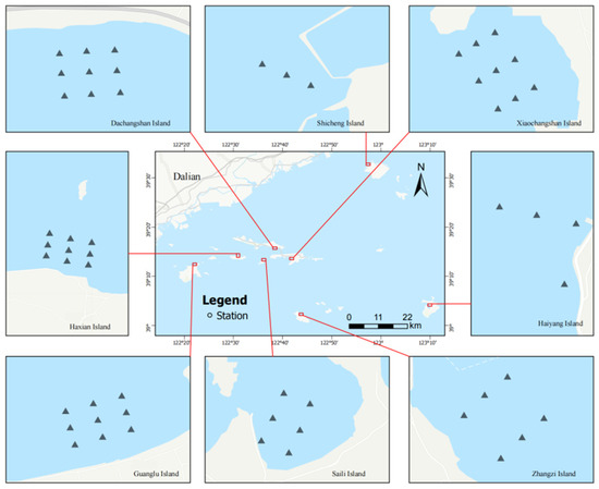
Figure 1.
Overview of sampling locations in the study area.
The distribution and area data of the seagrass beds were obtained through a combination of remote sensing identification and field surveys. The Matrice 350 RTK drone was used to photograph the nearshore waters of the survey area (mainly referring to waters with a depth of less than 6 m at low tide) to determine the boundaries and distribution of the seagrass beds. In cases where the Matrice 350 RTK drone could not complete the survey (e.g., when the seagrass patch area was too large or too far from the shore), high-resolution satellite images from the Gaofen-1 satellite were visually interpreted, and underwater surveys with divers were conducted to confirm the boundaries. Finally, the seagrass bed distribution map was created and the distribution area was determined by integrating the information from underwater verification, drone photography, and Gaofen-1 satellite data.
Seagrass samples were collected by setting a 50 cm × 50 cm quadrat at each survey station. A root sampler with a diameter of 10.00 cm to 25.00 cm was used to collect the seagrass samples to ensure plant integrity. During the collection, canopy cover was estimated for each quadrat. The selected water quality parameters for measurement included salinity (Sal), suspended solids (SS), pH, dissolved oxygen (DO), sea temperature (SST), nitrite nitrogen (NAN), nitrate nitrogen (NN), and ammonium nitrogen (SN), totaling eight indicators. The first three indicators were measured in the field using a portable water quality meter (YSI Professional Pro, Yellow Springs, OH, USA). For the SS indicator, surface seawater samples were first collected using a 10 L water sampler. A 1 L subsample was stored at a low temperature (4 °C) and then brought back to the laboratory for analysis [10].
2.2. Construction of Suitability Index
Previous studies have found that water environmental factors play a significant role in the degradation of seagrass meadows; therefore, this study focuses on the investigation of water-related environmental parameters [11]. The impact of seawater temperature on seagrass has been clearly addressed in previous studies, which indicate that the optimal temperature range for seagrass growth is 15–20 °C, and that temperatures below 25 °C do not adversely affect its development. As field investigations show that water temperatures in the northern Yellow Sea do not exceed 25 °C, this factor was not a primary focus in the present study [12].
The suitability index (SI) for each environmental variable was determined using the abundance index (AI) [13], which characterizes the habitat suitability distribution of seagrass resources. The SI quantifies the influence of each environmental factor on habitat quality. For instance, when evaluating seagrass bed habitats, Sal is considered a critical environmental parameter. The corresponding SI value indicates the degree to which Sal conditions support seagrass growth. An SI value approaching 1 suggests optimal Sal conditions, whereas a value near 0 implies that Sal may be a limiting factor [14]. This quantification enables researchers to compare the relative significance of different environmental factors in shaping habitat quality.
In this study, the standardized resource AI was employed to establish SI relationships for key environmental variables, including Sal, SS, pH, DO, SST, NAN, NN, and SN.
During data processing, statistical techniques such as the Z-score method were first applied to detect and exclude outliers, followed by mean value imputation for missing data. The SI values generally range from 0 to 1, with an SI of 1 indicating the most favorable habitat conditions for seagrass growth, corresponding to the maximum AI. Conversely, when the AI is 0, the habitat is deemed least suitable, and the SI is assigned a value of 0. The formula used for SI calculation is presented in Equation [15].
In the formula:
- SIi,k:
- The suitability index of environmental variable i at the k-th level;
- AIi,k:
- The resource density (g/h) of environmental variable i at the k-th level;
- AIi,min:
- The minimum resource density value of environmental variable i;
- AIi,max:
- The maximum resource density value of environmental variable i.
2.3. Model Construction
Based on the index relationship, the HSI system is constructed using a weight allocation method, with HSI values ranging from 0 (unsuitable) to 1 (most suitable). The SI values are combined to form the HSI. The calculation formula is as follows:
In the formula:
- Wq:
- The value of the i-th evaluation indicator;
- n:
- The total number of monitoring points in the evaluation area;
- Wqi:
- The value of the q-th evaluation indicator at the i-th monitoring point.
3. Results and Analysis
3.1. Characteristics of Seagrass Beds in the Changshan Archipelago
The characteristics of seagrass beds across the eight surveyed zones in the Changshan Islands are summarized in Table 1. The predominant seagrass species in this region belong to the eelgrass genus (Zostera). Among them, Zostera marina (common eelgrass) exhibits the highest occurrence frequency, followed by Zostera japonica (Japanese eelgrass), while Zostera caespitosa (tufted eelgrass) has the lowest occurrence frequency. The respective frequencies of occurrence for these species are 100.0%, 62.5%, and 50.0%. The average stem height of Zostera marina in the Changshan Islands ranges from 295.0 mm to 972.0 mm, with the tallest specimens recorded on Ocean Island and the shortest on Shicheng Island. Specifically, the average stem height on Ocean Island reaches 972.0 mm, whereas on Shicheng Island, it measures only 295.0 mm. The average stem height of Zostera japonica is highest on Ocean Island and Zhangzi Island, exceeding 1000.0 mm and reaching up to 1105.0 mm, while the lowest recorded height is 218.6 mm on Xiaochangshan Island. Only four surveyed zones support the growth of Zostera caespitosa, with the tallest specimens observed on Dazhangshan Island and the shortest on Zhangzi Island. The variation in stem height among the three Zostera species is relatively small, with Zostera caespitosa displaying the smallest height difference. On Zhangzi Island, the average stem height of Zostera caespitosa is 420.0 mm, while on Dazhangshan Island, it reaches 846.7 mm, resulting in a maximum–minimum height difference of 426.7 mm [16], the smallest among the three eelgrass species. The spatial distribution of the surveyed seagrass bed areas is illustrated in Figure 2.

Table 1.
Numerical statistical table of seagrass in the North Yellow Sea in 2022.
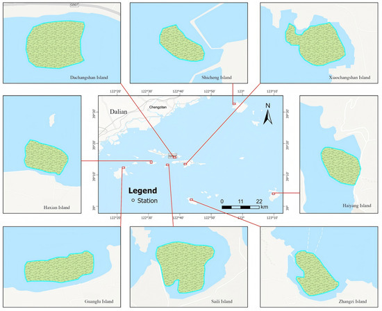
Figure 2.
Map of seagrass bed area.
3.2. Suitability Index and Curve of Environmental Variables
This study uses sea temperature, DO, pH, SS, and nutrients as environmental variables to assess habitat suitability [17]. These indicators are directly related to the physiological and ecological processes of seagrasses, and can comprehensively reflect the health status of seagrass bed ecosystems. Moreover, they are easy to monitor, ensuring the accuracy of the assessment results and the applicability of the methodology. Based on the field survey results, the suitability index for each environmental variable was calculated, summarized in Table 2, and the suitability curves were plotted (Figure 3).
Table 2.
Index table of water environment evaluation factors.
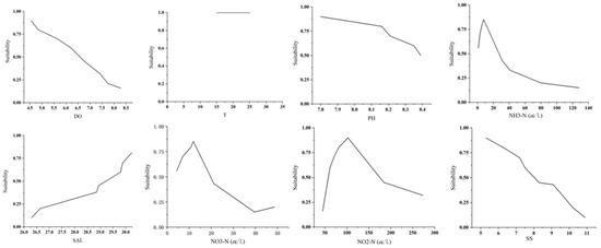
Figure 3.
Suitability curves of habitat factors for each water environment index.
Significant differences in habitat suitability for seagrass can be observed under varying environmental conditions. In northern coastal regions, seagrass beds typically develop within a specific temperature range and are primarily distributed at depths of 0–6 m. Sal plays a crucial role in regulating osmotic pressure in seagrass cells and directly influences photosynthesis [18]. In general, Sal exhibits a positive correlation with seagrass growth and reproduction [19]. The tolerance range for seagrass Sal is approximately 28.25–30.00, with an optimal range of 29.00–30.98. When Sal falls below 29 or exceeds 30.98, the growth rate of seagrass gradually declines as the deviation from the optimal range increases.
SS, pH, and DO all have specific suitability levels for seagrass bed growth. Values that are either too high or too low can inhibit seagrass growth [20]. The most suitable suspended solid concentration for seagrass beds is generally between 10 and 20 mg/L. Within this range, the water transparency is relatively high, allowing sufficient light to penetrate the water column and reach the seagrass leaves, thus meeting the photosynthesis requirements of the seagrass. The optimal SS concentration for eelgrass is below 15 mg/L. According to the survey, the SS concentration generally meets the growth conditions for seagrass beds. An appropriate pH level facilitates the absorption of essential nutrients by seagrass. Within the pH range of 7.5–8.16, seagrass has the highest absorption efficiency for key nutrients such as nitrogen and phosphorus. When the pH value is too high or too low, it may affect the chemical forms and bioavailability of nutrients in seawater, thereby limiting the absorption and utilization by seagrass, ultimately restricting its growth and development [21]. The optimal dissolved oxygen (DO) concentration for seagrass beds is generally between 5 and 8 mg/L. Within this range, seagrass can carry out normal aerobic respiration, providing sufficient energy for growth, reproduction, and maintaining physiological functions [22].
Seagrass beds remain in an open state of nitrogen absorption, with uptake rates increasing alongside nitrogen concentrations. However, excessive nitrogen levels can inhibit growth. The suitable nitrite-nitrogen concentration in seagrass habitats is generally low, with concentrations below 0.1 mg/L considered optimal. Within the range of 48.09–71.41 µg/L, nitrite-nitrogen promotes seagrass growth and reproduction. When the concentration stabilizes around 0.05 mg/L, seagrass growth remains unaffected, with biomass and photosynthetic efficiency sustaining equilibrium. The optimal nitrate-nitrogen concentration for seagrass beds generally falls within 0.1–2.0 mg/L. For instance, eelgrass can efficiently utilize nitrate-nitrogen at concentrations near 2.0 mg/L, maintaining a high growth rate. In contrast, Japanese eelgrass has a lower nitrate-nitrogen requirement and can grow normally in environments where concentrations are approximately 0.1 mg/L; however, slight increases beyond this threshold may result in physiological stress. Eelgrass exhibits limited tolerance to ammonia-nitrogen, with optimal concentrations ranging from 0.02 to 0.045 mg/L. Elevated ammonia-nitrogen concentrations can induce toxicity, adversely affecting photosynthesis and respiration, ultimately leading to inhibited growth or mortality [23].
The actual measurement data in 2022 indicated that the water temperature in the study area remained around 25 °C during the summer. According to the research conclusion of Burnell et al. (2014) [24], this temperature range falls within the suitable survival range of eelgrass (15–25 °C), suggesting that the summer water temperature conditions in the North Yellow Sea would not have a negative impact on the growth of seagrass beds. This result further validates the accuracy of the HSI model in assessing seagrass habitats [24].
3.3. Habitat Suitability Distribution of Seagrass Beds in Changshan Islands
The spatial distribution map of the seagrass HSI was drawn, the distribution of seagrass resource density was compared with the actual observed value, and the distribution differences and changes were discussed (Figure 4).
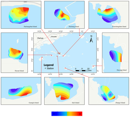
Figure 4.
Habitat situation in seagrass bed area.
In Figure 4, the color range from red to dark blue represents an HSI range from 0 to 1. The red region indicates that the water quality function has degraded, and the ecological environment has been severely damaged, making it unsuitable for seagrass survival. Conversely, the blue region represents areas highly suitable for seagrass growth. The intermediate colors reflect the gradual transition in suitability, as shown in Figure 4 [25]. Based on the analysis of the habitat suitability distribution map of seagrass beds in the study area, significant differences in habitat suitability can be observed among different islands. Overall, except for Haxian Island, most islands exhibit relatively low habitat suitability in their surrounding waters. In particular, coastal areas generally have lower habitat suitability, while suitability improves gradually as the distance from the shore increases.
Dachangshan Island: The habitat suitability in the waters around Dachangshan Island is predominantly represented by red areas, indicating low suitability (0–0.25). This suggests that water quality or environmental factors in this region significantly affect seagrass growth, making it unsuitable. However, as the distance from the shore increases, habitat suitability gradually improves, indicating that offshore areas are more favorable for seagrass growth.
Shicheng Island: The waters around Shicheng Island also exhibit generally low habitat suitability, with a large presence of red and orange areas, suggesting that these locations are not conducive to seagrass growth. Nevertheless, the southeastern and outer areas of the island show improved suitability, with cyan and blue regions indicating better water quality or environmental conditions.
Xiaochangshan Island: A similar trend is observed in the waters around Xiaochangshan Island. Nearshore areas are mainly red and orange, representing low habitat suitability, while offshore regions gradually transition to blue, indicating higher habitat suitability and better conditions for seagrass growth.
Haxian Island: Haxian Island exhibits a unique pattern of habitat suitability, with overall high suitability, especially in the southeastern part of the island, which is almost entirely represented by blue and cyan areas. This suggests that the water quality and environmental conditions in this region are highly favorable for seagrass growth. The island’s special geographical conditions make it an ideal habitat for seagrass.
Guanglu Island: The habitat suitability around Guanglu Island is relatively uniform, mainly represented by orange and cyan areas. This indicates that while the habitat is generally suitable for seagrass growth, some areas still have lower suitability, possibly due to localized water quality or other environmental factors.
Saili Island: Habitat suitability around Saili Island shows a distinct variation, with nearshore areas represented by red and orange, indicating low suitability. However, as the distance from the shore increases, the areas gradually transition to cyan and blue, signifying more favorable conditions for seagrass growth.
Zhangzi Island: Zhangzi Island has the highest habitat suitability among all the islands in the study. In particular, the southwestern part of the island is almost entirely represented by blue, indicating excellent conditions for seagrass growth. Compared to other islands, the waters around Zhangzi Island have superior water quality and ecological conditions, making it an ideal region for seagrass growth.
The Changshan Islands are located in a specific maritime region, with each island differing significantly in terms of geographical environment, oceanographic conditions, and surrounding human activities. These differences profoundly affect the suitability of the seagrass bed for growth, making Xiaochangshan Island the most suitable area for seagrass growth. In contrast, Saer Island and Zhangzi Island are located in an embayment, where the lack of hydrodynamics results in poor water circulation, making these areas unsuitable for seagrass. Other islands are relatively more suitable for seagrass growth.
Xiaochangshan Island is the most suitable for seagrass bed growth for several reasons. Its seawater Sal remains consistently within the optimal range for seagrass growth, providing ideal conditions for maintaining the osmotic pressure and physiological functions of seagrass cells. The suspended matter concentration is low, and the water is clear and transparent, allowing sufficient sunlight to penetrate to the seagrass growth area, which strongly supports photosynthesis. The pH of the water is moderate and generally stable within the optimal range for seagrass growth, which facilitates the absorption and utilization of various nutrients by the seagrass. The dissolved oxygen content is abundant, allowing both the seagrass roots and leaves to efficiently carry out respiration in this environment, providing sufficient energy for seagrass growth, reproduction, and metabolism. The ratios of nitrite nitrogen, nitrate nitrogen, and ammonia nitrogen are well-balanced and within optimal ranges, sufficiently meeting the nutrient requirements of seagrass while preventing ecological issues associated with nutrient overload. Additionally, the waters surrounding Xiaochangshan Island exhibit calm and stable currents, facilitating nutrient transport that is essential for seagrass growth while minimizing the mechanical damage caused by excessive water flow. This hydrodynamic stability provides highly favorable conditions for the sustained development of seagrass beds.
In contrast, Shicheng Island is the least suitable for seagrass bed growth. The surrounding seawater Sal of Shicheng Island fluctuates frequently and with a large amplitude, which poses a significant challenge to the osmotic pressure balance of seagrass cells, severely disrupting the normal physiological processes of the seagrass. The concentration of SS is excessively high, with large amounts of sediments and impurities filling the water, resulting in severe light deficiency. This inhibits seagrass photosynthesis, preventing the synthesis of sufficient organic material needed for growth. The pH often deviates from the suitable range for seagrass growth, either being too acidic or too alkaline, making it difficult for seagrass to effectively absorb nutrients. The efficiency of nutrient uptake and utilization is greatly reduced. Dissolved oxygen levels are relatively low, particularly during the cultivation period, and the hypoxic conditions restrict seagrass respiration, thus affecting its growth rate and overall health. The nutrient content is imbalanced, with some essential nutrients being severely lacking, while others may accumulate in excess, leading to a dual risk of nutrient deficiency and toxicity for seagrass. Additionally, human activities in the waters around Shicheng Island are frequent, such as large-scale port construction and shipping operations, which not only destroy the original habitat of the seagrass beds but also introduce large amounts of pollutants, further deteriorating the seagrass’s living environment. These judgements are based on observations and analyses obtained from the 2022 in situ field survey. The other islands fall between the two extremes and are relatively suitable for seagrass bed growth. Although salinity on these islands fluctuates to some extent, it generally remains within the tolerance range for seagrass, and its physiological impact on seagrass is relatively minor. Environmental factors such as SS concentrations, pH, DO content, and nutrient ratios, while not as ideal as those of Xiaochangshan Island, still largely meet the growth requirements of seagrass. The surrounding water flow conditions are relatively favorable, without excessive mechanical disturbance to seagrass or significant hindrance to nutrient exchange [26]. Although these islands are affected to some degree by human activities, such as moderate fishing and tourism development, the impacts remain within controllable limits through reasonable planning and management [27]. As a result, these influences have not caused catastrophic harm to seagrass bed growth, allowing the seagrass beds on these islands to maintain a certain scale and ecological function.
4. Validation of the HSI Model
The HSI model developed in this study was constructed based on empirical data collected in 2022 from the coastal areas surrounding various islands in the northern Yellow Sea. To evaluate the predictive performance and applicability of the model, a follow-up field investigation was conducted in 2024 in the same regions. Sampling was carried out at identical geographic coordinates, and the same methodology as in 2022 was employed to reassess the distribution and areal extent of the seagrass meadows around the islands. A comprehensive field survey conducted on August 30, 2024 provided an updated assessment of the spatial and temporal patterns of seagrass distribution in the region, revealing consistent spatial trends and dynamic changes in seagrass growth. Subsequently, a comparative analysis was performed between the model predictions derived from the 2022 HSI model and the seagrass coverage data measured in 2024. This analysis effectively validated the model’s predictive accuracy and its reliability for practical application.
By comparing the total island seagrass area measurements between Table 3 (current the survey) and Table 1 (baseline data), we derived the comparative results presented in Table 4.
Table 3.
Numerical statistical table of seagrass in the North Yellow Sea in 2024.
Table 4.
Detailed table of seagrass bed degradation around islands in 2022 and 2024.
In Table 4, the symbol “◯” indicates that based on the on-site investigation results, the seagrass beds have deteriorated in 2024, while the symbol “×” represents that they have not deteriorated but have grown instead.
The survey data from 2024 show that the seagrass beds around Shishangcheng Town, Haixian Island, Zangzi Island, and Sali Island have all experienced varying degrees of degradation. Based on the analysis results of the HSI model shown in Figure 4, the degradation conditions of each island are significantly different.
Due to the long-term presence of large-scale floating raft aquaculture facilities in the waters of Seri Island and Haixian Island, the model prediction as early as 2022 indicated that the seagrass beds in these areas had shown a trend of degradation. In the 2022 assessment of Shishangcheng waters, the areas of suitable and unsuitable zones were basically the same, and no signs of degradation were observed. However, the latest investigation revealed that the area of seagrass beds in this region had decreased by 20.77 hectares, with the most significant degree of degradation. In contrast, according to the on-site observations and model calculations in 2022, the seagrass beds in Zhaosidao remained stable, but this investigation also found signs of degradation. Based on the results of on-site investigation, the degradation of seagrass beds in Zhangzidao sea area is mainly attributed to the construction project of the cross-sea bridge in Changhai County. The construction pollutants generated during the construction process directly affected the growth environment of seagrass in this area, resulting in a significant degradation of the seagrass bed ecosystem. Meanwhile, the degradation of seagrass beds in Shisheng County sea area is even more serious. The main reason for this is the significant increase in the number of floating rafts for aquaculture in this sea area since 2022. The expansion of aquaculture activities has significantly changed the original marine environment, thereby causing a serious impact on the seagrass bed ecosystem.
According to the 2022 HSI model assessment results, the overall survival environment quality of seagrass beds in the waters of Dachangshan Island, Xiaochangshan Island, Haiyang Island, and Guanglu Island is good. The latest on-site investigation data in 2024 further confirmed that the areas of seagrass beds in the above four islands have all shown varying degrees of growth, and the overall ecological environment has maintained stable development.
5. Conclusions
This study comprehensively considered both relatively fixed water environment factors and variable water environment factors such as Sal and inorganic salts, and developed an HSI model to conduct an in-depth investigation of the seagrass bed growth areas in the Changshan Islands. The study found the following:
- (1)
- The water environment features around Xiaochangshan Island, including indicators such as salinity (Sal), suspended solids (SS), pH, dissolved oxygen (DO), sea temperature (SST), nitrite-nitrogen (NAN), nitrate-nitrogen (NN), and ammonia-nitrogen (SN), all fall within highly suitable ranges, perfectly meeting the water environment requirements for seagrass growth [22]. In contrast, Shicheng Island has an excessively high level of inorganic nutrients, resulting in poor seagrass growth. This comparison highlights the significant impact of inorganic nutrients on seagrass growth, where even minor fluctuations can drastically alter the growth conditions of seagrass. The growth conditions on Saeri Island, compared to Xiaochangshan Island, are primarily influenced by hydrodynamics. Saeri Island has relatively low DO levels and a weaker water movement, which results in a lower oxygen content. Additionally, hydrodynamics may also affect the dispersal range and settlement probability of seagrass seeds and reproductive bodies; excessive water flow can prevent seeds from successfully settling. This analysis provides strong empirical evidence and data support for the seagrass growth model constructed for this environment, further validating the scientific and reliable nature of the model, and offering an important reference for seagrass ecological research and conservation in other similar regions.
- (2)
- The water environment sensitive areas in the HSI model of seagrass beds are of vital importance for resource protection. These areas are crucial for maintaining the core populations. The protection of the Haishan Islands’ seagrass beds needs to focus on the prevention of human interference and coordinate the management of surrounding habitats to avoid habitat fragmentation. The 2024 field investigation results show that the sampling point data are highly consistent with the predictions of the HSI model, verifying the reliability of the model. The potential suitable habitats identified by the model not only provide a scientific basis for resource restoration but also offer important guidance for the practice of artificial seagrass restoration. The potential suitable habitat areas identified through this model hold greater practical value for resource restoration, and they significantly contribute to the research on the artificial supplementation and restoration of seagrass resources [28].
- (3)
- Currently, the booming aquaculture industry in the Changshan Archipelago has led to severe water quality pollution issues. Aquaculture waste, drug residues, and biological excrement have made it difficult to maintain an optimal water environment for seagrass beds, resulting in a vicious cycle of seagrass decline and water quality deterioration. To ensure the sustainable development of marine ecosystems, it is essential to control the scale of aquaculture, reduce pollution, continuously monitor water quality, and strengthen the protection of surrounding areas to promote seagrass recovery. Although this study analyzes the seagrass bed habitat in the Changshan Archipelago based on eight water environmental factors using the HSI model, seagrass habitats are regulated by a complex network of factors, with some factors having a profound impact on the seagrass habitat under specific conditions [24]. Future research should further explore potential environmental factors that influence seagrass population growth, reproduction, and migration, in order to enhance the accuracy and applicability of the HSI model, providing a more solid theoretical foundation and practical guidance for the scientific protection and precise restoration of seagrass bed ecosystems.
Author Contributions
Conceptualization, Y.F. and J.S.; methodology, Y.S.; software, Y.S.; validation, Y.F., W.H. and Y.W.; formal analysis, W.H.; investigation, J.Y.; resources, Y.F.; data curation, Y.S.; writing—original draft preparation, Y.S.; writing—review and editing, Y.F.; visualization, J.G.; supervision, Y.W.; project administration, J.S.; funding acquisition, J.Y. All authors have read and agreed to the published version of the manuscript.
Funding
This research was funded by the Scientific Research Project of Education Department of Liaoning Province (LJ212410158037, LJ232410158056); Dalian Science and Technology Innovation Fund (2024JJ11PT007); Dalian Science and Technology Program for Innovation Talents of Dalian (2022RJ06) Science and Technology Plan of Liaoning Province (2024JH2/102400061).
Institutional Review Board Statement
Not applicable.
Informed Consent Statement
Not applicable.
Data Availability Statement
The original contributions presented in this study are included in the article. Further inquiries can be directed to the corresponding author.
Acknowledgments
We thank the Data Support from National Marine Scientific Data Center (Dalian), National Science & Technology Infrastructure of China (http://odc.dlou.edu.cn/) for providing valuable data and information. We also thank the reviewers for carefully reviewing the manuscript and providing valuable comments to help improve this paper.
Conflicts of Interest
The authors declare no conflicts of interest.
References
- Zhou, Y.; Jiang, Z.; Qiu, G.; Zhang, P.; Xu, S.; Zhang, X.; Liu, S.; Li, W.; Wu, Y.; Yue, S.; et al. Current Status of Seagrass Resource Distribution, Causes of Degradation, and Conservation Strategies in China. Ocean. Limnol. 2023, 54, 1248–1257. [Google Scholar]
- Li, R.; Shen, Y.; Shao, Y.; Gao, Y.; Yao, Z.; Liu, Q.; Liu, X.; Shi, G. Measurement Report: Polycyclic aromatic hydrocarbons (PAHs) and their alkylated (RPAHs), nitrated (NPAHs) and oxygenated (OPAHs) derivatives in the global marine atmosphere: Occurrence, spatial variations, and source apportionment. EGUsphere 2025, 2025, 1–22. [Google Scholar]
- Unsworth, R.K.; Nordlund, L.M.; Cullen-Unsworth, L.C. Seagrass meadows support global fisheries production. Conserv. Lett. 2019, 12, e12566. [Google Scholar] [CrossRef]
- Bennett, S.; Wernberg, T.; Connell, S.D.; Hobday, A.J.; Johnson, C.R.; Poloczanska, E.S. The ‘Great Southern Reef’: Social, ecological and economic value of Australia’s neglected kelp forests. Mar. Freshw. Res. 2015, 67, 47–56. [Google Scholar] [CrossRef]
- Zhong, C.; Liao, Y.; Liu, W.; Sui, H.; Chen, Q. Current Status, Threats, and Conservation Recommendations for Seagrass Beds along the Guangdong Coast. Biodiversity 2024, 32, 23201. [Google Scholar]
- Zeng, X.; Zhang, S.; Wang, Z. Habitat Suitability Assessment of Sebasticus marmoratus in the Ma’an Archipelago. Acta Ecol. Sin. 2016, 36, 3765–3774. [Google Scholar]
- Han, Q.; Shi, P. Research Progress in Seagrass Ecology. Acta Ecol. Sin. 2008, 28, 5561–5570. [Google Scholar]
- Pei, P.; Aslam, M.; Yang, C.; Ye, P.; Ke, X.; Liang, Z.; Li, T.; Chen, W.; Du, H. Temporal variations of biological nitrogen fixation and diazotrophic communities associated with artificial seaweed farms. Front. Mar. Sci. 2024, 11, 1408958. [Google Scholar] [CrossRef]
- Shi, H.; Zheng, W.; Ding, D.; Lv, J.; Zhang, X. Assessment of Ecosystem Services Functions and Values in Typical Marine Ecosystems—A Case Study of Sanggou Bay. Mar. Environ. Sci. 2008. [Google Scholar] [CrossRef]
- GB/T12763.8-2007; Specifications for Oceanographic Survey—Part 8: Marine Geology and Geophysics Survey. National Standards of People’s Republic of China: Beijing, China, 2007.
- Orth, R.J.; Carruthers, T.J.; Dennison, W.C.; Duarte, C.M.; Fourqurean, J.W.; Heck, K.L.; Hughes, A.R.; Kendrick, G.A.; Kenworthy, W.J.; Olyarnik, S.; et al. A global crisis for seagrass ecosystems. Bioscience 2006, 56, 987–996. [Google Scholar] [CrossRef]
- Marsh, J.A., Jr.; Dennison, W.C.; Alberte, R.S. Effects of temperature on photosynthesis and respiration in eelgrass (Zostera marina L.). J. Exp. Mar. Biol. Ecol. 1986, 101, 257–267. [Google Scholar] [CrossRef]
- Liu, X.; Gao, C.; Tian, S.; Qin, S.; Ma, J.; Zhao, J. Optimal Habitat Distribution of Larimichthys polyactis in the Southern Offshore Waters of Zhejiang Based on the Habitat Suitability Index. Chin. Fish. Sci. 2020, 27, 1485–1495. [Google Scholar]
- Melo-Merino, S.M.; Reyes-Bonilla, H.; Lira-Noriega, A. Ecological niche models and species distribution models in marine environments: A literature review and spatial analysis of evidence. Ecol. Model. 2020, 415, 108837. [Google Scholar] [CrossRef]
- Rowan, G.S.L.; Kalacska, M. A review of remote sensing of submerged aquatic vegetation for non-specialists. Remote Sens. 2021, 13, 623. [Google Scholar] [CrossRef]
- Zhi, K.; Yang, J.; Yin, Z.; Wang, Y. Distribution Characteristics of Seagrasses, Seaweeds, and Epibiota in the Seagrass Beds of the Changshan Archipelago, Dalian. Mar. Fish. 2024, 46, 297–306. [Google Scholar] [CrossRef]
- Hastings, R.; Cummins, V.; Holloway, P. Assessing the impact of physical and anthropogenic environmental factors in determining the habitat suitability of seagrass ecosystems. Sustainability 2020, 12, 8302. [Google Scholar] [CrossRef]
- Tang, H.-M.; Zhao, L.; Wang, H.-L.; Fang, K.-P.; Wang, H.-W. Early Development Life History And Environmental Factors On The Growth And Development Of Sparlingia Pertusa. Acta Hydrobiol. Sin. 2025, 49, 032507. [Google Scholar]
- Liu, W.; Xin, M.; Zhou, J.; Zhan, D.; Ding, G.; Wu, H. Habitat hierarchy distribution of Smilax glabra based on habitat suitability index model. Chin. J. Appl. Ecol. Xuebao 2021, 32, 1061–1068. [Google Scholar]
- Zheng, X.; Shen, Y. Composition and correlation with environmental factors of benthic seaweed species in the sea area of Dalian. J. Dalian Fish. Univ. 2024, 39, 648–656. [Google Scholar]
- Mulders, Y. Changes in Temperate Seaweed Communities and the Associated Subtidal Reef Ecosystem; The University of Western Australia: Perth, Australia, 2021. [Google Scholar]
- Zhao, J.; Yang, W.; Bai, J. Evaluation system establishment of nursery function for three seagrass beds and their spatial differences in the nearshore Bohai Sea. Haiyang Xuebao 2025, 47, 1–14. [Google Scholar]
- Crooks, S.; Troxler, T.; Windham-Myers, L. A Blue Carbon Primer; CRC Press: Boca Raton, FL, USA, 2018. [Google Scholar]
- Burnell, O.W.; Russell, B.D.; Irving, A.D.; Connell, S.D. Seagrass response to CO2 contingent on epiphyte algae interactions. Mar. Ecol. Prog. Ser. 2014, 500, 97–109. [Google Scholar]
- Guo, M.; Cao, L.; Dong, J.; Bidegain, G.; Yang, X.; Xu, H.; Li, H.; Zhang, X.; Liu, G. An Ensemble Habitat Suitability Model Predicts Distribution and Resiliency of Suaeda Salsa Under Extreme Climate Events. SSRN 2024. [CrossRef]
- Zhang, Z.; Yang, W.; Zhang, Z.; Sun, T. Characteristics of Typical Biological Communities in Seagrass Beds and Identification of Key Environmental Factors in the Xingcheng-Juehua Island Waters of the Bohai Sea. J. Beijing Norm. Univ. Nat. Sci. Ed. 2022, 58, 90–98. [Google Scholar]
- Zhang, J.; Jiang, Z.; Wang, W.; Zhou, J. Spatial and Temporal Distribution of Nutrients in Sanggou Bay and Analysis of Nutrient Limitation. Prog. Fish. Sci. 2010, 16–25. [Google Scholar] [CrossRef]
- Guo, M.; Li, W.; Yang, X.; Zhang, X. Growth Adaptation of Zostera marina in Different Habitats of Swan Lake, Rongcheng. Chin. J. Appl. Ecol. 2017, 28, 1498–1506. [Google Scholar]
Disclaimer/Publisher’s Note: The statements, opinions and data contained in all publications are solely those of the individual author(s) and contributor(s) and not of MDPI and/or the editor(s). MDPI and/or the editor(s) disclaim responsibility for any injury to people or property resulting from any ideas, methods, instructions or products referred to in the content. |
© 2025 by the authors. Licensee MDPI, Basel, Switzerland. This article is an open access article distributed under the terms and conditions of the Creative Commons Attribution (CC BY) license (https://creativecommons.org/licenses/by/4.0/).