1. Introduction
The conservation and rehabilitation of historical irrigation systems play a crucial role in sustainable water management and rural resilience [
1,
2,
3]. Throughout history, traditional water distribution networks have enabled agricultural productivity, fostered community stability, and contributed to the preservation of biodiversity [
4]. However, many of these infrastructures face deterioration due to socio-economic changes, land abandonment, and climate-related challenges [
5,
6]. The Acequia del Diablo (Devil’s Canal), an ancient irrigation canal in Teruel, Spain, exemplifies this reality. As a system of Islamic origin [
7], it is not only a functional component of water distribution, but also a recognized element of cultural and environmental heritage, officially listed in the Aragonese Cultural Heritage Information System (SIPCA) [
8]. SIPCA is a regional database managed by the Regional Government of Aragón that catalogs and safeguards elements of cultural and environmental significance. This inclusion signifies the acequia’s dual role as both a hydraulic infrastructure and a historical asset, underscoring its importance in shaping the cultural landscape of the Olba Valley. Being cataloged in SIPCA not only acknowledges its Islamic origin and centuries-old operation, but also implies that its conservation is a matter of public interest, deserving of institutional protection and prioritization within regional planning and sustainability strategies.
The current precarious state of the Acequia del Diablo results from the combined impact of structural damage due to landslides and the subsequent loss of its water source. In 1992, significant landslides occurred in the Barranco de Linares area, precisely where the spillway of the San Agustín Hydroelectric Canal discharged into the ravine. These mass movements destroyed critical sections of the acequia, particularly the carved conduits that allowed water conveyance along steep slopes, effectively severing the hydraulic continuity of the system. This event rendered the downstream portions inoperative and led to the progressive abandonment of agricultural land historically sustained by this infrastructure.
In an effort to preserve irrigation functionality, a temporary intake was authorized from the hydroelectric canal connected to the Los Toranes reservoir. However, on December 2020, this auxiliary intake was decommissioned following the expiration of Iberdrola’s hydroelectric concession and the Ministry for the Ecological Transition’s (MITECO) decision to initiate the dismantling process of the dam [
9]. This resulted in a complete cessation of water flow through the acequia, leaving the entire system dry. The combined effect of these two events—physical disconnection due to landslides and the elimination of water input—has critically compromised the acequia’s operability, accelerating land abandonment, disrupting ecological connectivity, and increasing wildfire risk in the Olba valley.
In addition to its historical and hydraulic significance, the Acequia del Diablo runs adjacent to a newly constructed pedestrian walkway suspended over the Mijares River gorges, inaugurated in early 2025 near Casa Bolea. This infrastructure not only enhances public access to the dramatic landscape of the Estrechos del Mijares, but also provides a unique opportunity to integrate heritage irrigation systems into the region’s eco-tourism strategy. The proposed rehabilitation of the acequia would restore water flow to areas visible from the walkway, creating a living demonstration of traditional water management practices in their original setting. This synergy between restored hydraulic heritage and sustainable tourism infrastructure can reinforce both cultural appreciation and local economic development, aligning with broader goals of territorial revitalization.
Moreover, the rehabilitation strategy builds upon the methodological framework developed in the European MEMOLA project (Mediterranean Mountainous Landscapes), which focused on the recovery of historic irrigation systems in Andalusia [
10]. MEMOLA demonstrated that successful rehabilitation of traditional acequias requires a transdisciplinary approach that combines hydrological engineering, environmental conservation, and community participation. Drawing directly from this model, the Acequia del Diablo project integrates detailed hydraulic analysis, geomorphological assessment, and stakeholder engagement to ensure both technical feasibility and social legitimacy. As in MEMOLA, the approach here emphasizes not only infrastructure repair, but also the recovery of traditional governance structures and maintenance practices, recognizing acequias as socio-ecological systems that support biodiversity, rural economies, and cultural identity. The Acequia del Diablo rehabilitation thus serves as a concrete case of how MEMOLA’s replicable model can be adapted to the specific conditions of inland Aragón, contributing to the preservation and reactivation of Mediterranean hydraulic heritage in the face of contemporary challenges.
In areas characterized by water scarcity but cultivated since ancient times, remains of historical aqueducts—such as gravity-fed acequias—are often found as enduring evidence of rural hydraulic systems adapted to local environmental conditions. The underlying thesis is that these remains, when properly diagnosed and restored, can be effectively reused for the sustainable development of the territory, contributing to water security, landscape conservation, and socio-economic revitalization. This framing aligns with the case of the Acequia del Diablo in the Olba Valley, where historical irrigation infrastructure is shown to retain both functional and territorial relevance, and where its rehabilitation represents a feasible and low-impact strategy for reactivating traditional agricultural practices.
2. Materials and Methods
2.1. The Water Management System in the Olba Valley (Spain)
The section of the Acequia del Diablo under consideration in this study is in Teruel, Spain, traversing several municipalities (Mora de Rubielos, Rubielos de Mora, San Agustín, and Olba). It originates in the Estrechos del Río Mijares, specifically at the Azud del Puente de la Fonseca, also known as Puente Viejo del Diablo. The acequia extends predominantly through rugged terrain, within an area designated as part of the Red Natura 2000 network [
11] and classified as a Site of Community Importance (LIC ES 2420128). Due to the significant incision of the Mijares River and its pronounced slope, the acequia gradually gains elevation along its course.
The Acequia del Diablo plays a vital role in sustaining the traditional agricultural systems of the highland areas in the Olba Valley, including Masía del Palacio (Casa Sardina) and the cultivated terraces of Casa Bolea, La Verdeja, Las Ventas, and Los Giles. These landscapes depend on the continuous flow of gravity-fed irrigation to maintain soil fertility, support perennial crops, and enable crop diversification on otherwise marginal land. The extension known as the Regadera de los Giles exemplifies this functionality, channeling water to one of the most structurally intact sectors of the historical irrigation network. Both this branch and the main acequia are officially recognized as elements of hydraulic heritage in the catalog maintained by the Confederación Hidrográfica del Júcar (CHJ), reflecting their long-standing agronomic and territorial relevance. Altogether, the network irrigates an estimated 60 hectares of traditional farmland, forming the backbone of a low-input, resilient agricultural system whose sustainability hinges on the preservation and operation of these historic water infrastructures.
Approximately 1.5 km from its starting point, it provides irrigation to the first cultivated fields in the Mas de Palacio area. At 3.6 km, it passes in front of Las Cuevas de la Hoz, supplying water to the small agricultural plots located there. At around 4.3 km, the acequia enters the municipality of Olba, where it continues irrigating numerous properties before reaching its terminus at the Barranco (Ravine) de Alonso, situated 13 km from its point of origin.
The total historical length of the Acequia del Diablo remains uncertain, with archival and topographic evidence suggesting that its original reach may have extended beyond the currently visible terminus at the Barranco de Alonso, potentially irrigating lands in what is now the submerged area of La Puebla de Arenoso. This uncertainty is not merely of historical interest—it holds practical implications for the current rehabilitation project. Understanding the full extent of the acequia’s historical reach could inform decisions on the potential recovery of now-disconnected irrigation sectors, support heritage conservation planning, and guide future expansions of the restoration beyond the 3.3 km currently under consideration. Moreover, reconstructing the acequia’s original layout would help clarify its role in shaping past land use patterns, settlement distribution, and ecological corridors within the valley. Recognizing this broader context reinforces the acequia’s territorial significance and underlines the need to integrate archeological, hydrological, and geomorphological investigations into the rehabilitation strategy.
This study proposes the rehabilitation of a 3327 m section of the Acequia del Diablo, beginning at the Azud (weir) de Fonseca, with the objective of restoring its functionality and preserving its historical significance as an essential irrigation infrastructure. The decision to rehabilitate this section of the Acequia del Diablo was based on a combination of hydraulic, structural, and territorial criteria established through detailed technical field surveys and stakeholder consultations. This stretch—extending from the historical intake at the Azud de Fonseca to the landslide-affected area at the Barranco de Linares—represents the most critical segment for restoring the acequia’s functionality as a gravity-fed irrigation system. It encompasses the primary water source, the most intact historical alignments, and the majority of the agricultural plots still suitable for traditional cultivation. Moreover, this section includes key hydraulic features such as carved conduits and mixed-material channel segments, whose preservation is essential for maintaining the cultural and technical integrity of the infrastructure. Rehabilitating this portion ensures the reconnection of the acequia’s upstream intake with the highland terraces of the Olba Valley, enabling the reactivation of approximately 60 hectares of traditional farmland. It also provides a technically coherent and administratively feasible intervention zone, as it lies entirely within the current concession boundaries and avoids dependencies on decommissioned hydroelectric infrastructure.
Figure 1 shows the location of the Acequia del Diablo in the Olba valley.
2.2. Historical Background
Although there is no precise information regarding the construction date of the Acequia del Diablo, it is generally attributed to Arab origins. This hypothesis is further supported by [
7], who state that the southern half of the province of Teruel, which was sparsely populated during the Caliphate period, saw its first significant settlements flourish under the Taifa kingdoms. They suggest that it was during the 11th century that the first hydraulic infrastructures were likely constructed, marking the beginning of an organized irrigation system in the region.
The development and gradual expansion of the Acequia del Diablo and associated terraced irrigation systems played a decisive role in shaping the territorial structure and enabling sustained population growth in the Olba Valley. When the Town Council of Teruel sold Olba to Pedro Ladrón in 1269, historical evidence suggests that the area was only sparsely inhabited, with limited capacity for intensive agriculture due to the steep topography and arid climate. The introduction of gravity-fed irrigation infrastructure, however, transformed these constraints into opportunities. By enabling the cultivation of terraced slopes and ensuring a reliable water supply, the acequia system facilitated the transition from marginal subsistence to a productive agroecosystem. This shift laid the foundation for demographic expansion: from nine households in 1495 to 200 residents by 1610 and over 650 by the end of the 18th century. The agricultural intensification supported by the acequia reached its apex in the late 19th century, when the population peaked at 2144 inhabitants—a density of 102 inhabitants per square kilometer, unprecedented for a mountainous inland region. This demographic growth was intrinsically tied to the acequia’s role in enabling food security, surplus production, and permanent settlement in an otherwise challenging environment.
The Acequia del Diablo and the terraced agricultural fields of the Estrechos del Mijares (Mijares’ Canyons) and the Olba Valley stand as prime examples of traditional irrigation landscapes and economies. As highlighted by [
12], “the riverine landscape is further enriched by fallen rock formations from the slopes, riparian vegetation, and terraced agricultural fields—both active and abandoned—marked by dry-stone walls and acequias, forming a unique assemblage of natural and cultural heritage”.
The Acequia del Diablo has been in operation for more than 700 years, drawing water from the Mijares River at the Azud de Fonseca, located on its right bank. The characteristics of the Azud de Fonseca are described in Sheet 105, which is included in the Catalog of Hydraulic Heritage of Alto Mijares Turolense [
13]. This system has historically served as a critical irrigation infrastructure, ensuring the distribution of water to agricultural lands in the Olba Valley.
The operation of the Acequia del Diablo has historically been governed by a formal water use concession granted by the Confederación Hidrográfica del Júcar (CHJ), which legally authorizes the Community of Irrigators of Olba to divert a defined volume of water—specifically 280,599 m3 per year—from the Mijares River. In practical terms, this concession establishes both the maximum annual volume and the associated irrigable area, which is officially recognized as 48.656 hectares. This regulatory framework ensures that water extraction remains within sustainable hydrological limits while providing legal security to the irrigators for long-term planning and infrastructure investment. The concession also serves as the basis for prioritizing water allocation, maintaining historical rights, and defining the administrative boundaries within which rehabilitation and maintenance works must be executed. Importantly, because the concession is tied to the original intake at the Azud de Fonseca, its restoration not only aligns with legal obligations, but also allows the acequia to operate autonomously, without relying on external infrastructure such as hydroelectric canals or pumping systems.
Figure 2 shows the current state of the Azud de Fonseca, which used to be the starting section of the Acequia del Diablo.
The acequia extends approximately 3.3 km, traversing a combination of earthen channels, concrete-reinforced sections, and ancient excavated conduits. It reaches the Barranco de Linares, located at the head of the Olba Valley, where it historically crossed the ravine via a carved-out hydraulic passage along its walls. Over the centuries, the acequia was maintained through a community-based system, where local officials known as “mayordomos” and “oficiales acequieros” oversaw its upkeep [
7]. The residents participated voluntarily, but out of their own interest, as they depended on their orchards either for self-sufficiency or for commercial purposes. They were paid what was known as “Jornales de la Acequia” (irrigation wages), and due to its length and complex topography, this irrigation channel even had its own management syndicate within the Irrigation Community. This syndicate was composed of the residents themselves from all the upper neighborhoods. During the 20th century, this role was increasingly undertaken by residents and irrigators, who performed necessary inspections and repairs in exchange for wages.
The 1992 landslides in the Barranco de Linares had severe and lasting impacts on both the structural integrity of the Acequia del Diablo and the ecological stability of the surrounding area. Triggered in part by concentrated discharges from the spillway of the San Agustín Hydroelectric Canal, which released excess water over a steep escarpment, these mass movements destroyed a critical segment of the acequia carved into the ravine walls. As a result, the hydraulic continuity of the system was abruptly severed, halting water distribution to downstream sections. Beyond the immediate functional disruption, the landslides altered the geomorphological dynamics of the barranco, contributing to slope destabilization and vegetation loss. The absence of flowing water in the damaged acequia has further exacerbated erosion processes and interrupted the formation of microhabitats previously sustained by irrigation seepage. Over time, these changes have likely diminished the valley’s ecological resilience, reduced the natural regulation of surface runoff, and compromised the connectivity of semi-aquatic and riparian ecosystems in this protected Natura 2000 area. The rehabilitation of the acequia, therefore, is not only a technical restoration, but also an ecological intervention aimed at mitigating the long-term environmental degradation set in motion by the 1992 event.
Following administrative procedures with the CHJ, the Community of Irrigators of Olba obtained approval to relocate the intake point, allowing water to be drawn from the hydraulic canal spillway instead. This modification temporarily restored irrigation to Casa Bolea and the highland settlements of Olba, though it left the original segment from the Azud de Fonseca to the Barranco de Linares abandoned. As a result, the 3.3 km stretch of the Estrecho de Mijares remained non-operational, further degrading over time.
On 2 December 2020, the spillway intake that had temporarily supplied the Acequia del Diablo with water since the 1992 landslides was officially decommissioned. This decision followed the expiration of Iberdrola’s concession for the Toranes–San Agustín hydroelectric infrastructure and was executed by the Spanish Ministry for the Ecological Transition and the Demographic Challenge (MITECO) as part of a broader strategy to phase out obsolete or underperforming hydraulic works. The decommissioning process was guided by national river basin management objectives, which prioritize the ecological restoration of rivers and the removal or transformation of non-essential barriers. However, the implementation of this policy did not fully account for the dependency that local traditional irrigation systems—such as the Acequia del Diablo—had developed on these infrastructures during the interim decades.
The immediate consequence of this administrative action was the complete cessation of water flow to the acequia, as the original intake at the Azud de Fonseca had remained inoperative since the 1992 landslides. This abrupt loss of irrigation water triggered widespread agricultural abandonment, particularly in the highland terraces of Olba, where cultivation is only viable under gravity-fed irrigation. In the short term, this led to the drying out of soils, desiccation of riparian vegetation, and the collapse of local agroecological practices. In the long term, the absence of irrigation flow has compromised microclimate regulation, reduced groundwater recharge in shallow perched aquifers, and increased the valley’s vulnerability to wildfires due to the accumulation of dry biomass. Furthermore, it severed a key ecological corridor previously sustained by the acequia’s seepage and overflows, thereby degrading the habitat quality for amphibians, pollinators, and other species. The decommissioning thus underscores the unintended consequences of infrastructure withdrawal in areas where traditional systems have become reliant on secondary sources, and it highlights the urgency of restoring autonomous and historically consistent water intake points.
Figure 3 shows a picture of the current state of Los Toranes reservoir.
2.3. Territorial, Demographic, and Cultural Impacts Resulting from the Discontinuation of the Acequia del Diablo: Land Use Change, Wildfire Risk, and Heritage Degradation
The cessation of operation of the Acequia del Diablo has triggered profound territorial and land use impacts, affecting agricultural productivity, demographic dynamics, wildfire risk, ecological connectivity, and cultural heritage. The absence of irrigation has led to a cascade of consequences that threaten the socio-environmental stability of the region.
One of the most immediate and far-reaching consequences of the acequia’s discontinuation is the abandonment of self-sufficient agriculture and the progressive degradation of cultivated land. Deprived of a reliable water supply, local farmers have been compelled to halt traditional irrigation-based practices that historically sustained household economies and supported a diversified agroecosystem. This disruption undermines more than just food production—it dismantles a resilient and low-external-input economic model rooted in circular resource use, intergenerational knowledge, and territorial stewardship. Such models offer long-term stability, buffer communities against market volatility, and reduce dependence on fossil fuel-based inputs and global supply chains. Their collapse results in the erosion of agroecological capital, a loss of seed diversity, and the disappearance of traditional labor structures, all of which are difficult to recover. Furthermore, the decline of irrigated landscapes has discouraged recent efforts toward rural repopulation. Families and individuals seeking to establish agroecological initiatives or engage in land-based livelihoods now encounter an environment unable to support basic productive functions. The interruption of the Acequia del Diablo has therefore not only triggered land abandonment, but also critically weakened the region’s capacity to maintain alternative development models centered on sustainability, food sovereignty, and local autonomy—accelerating depopulation trends common across inland Spain.
Another critical consequence is the increased vulnerability to wildfires. The Olba Valley, classified as a Site of Community Importance (SCI) under the Red Natura 2000 network, is an area of high ecological value. The abandonment of irrigation not only reduces water availability for fire control, but also contributes to the accumulation of dry vegetation, increasing the likelihood and intensity of wildfires. Without irrigation infrastructure, the community is left defenseless against forest fires, lacking even the most basic means to manage fire outbreaks before emergency brigades arrive. The devastating forest fire of 23 March 2023 severely affected the Alto Mijares region and the Olba valley [
14]. This fire, which advanced to just 1.5 km from the Olba valley and the upper neighborhoods, forced the evacuation of numerous communities. Before the evacuation, residents were instructed to overflow the irrigation channels to create moisture barriers and hinder the fire’s spread. However, the Diablo irrigation channel, which runs along the eastern and southeastern perimeter of the valley, was unable to serve as a natural firebreak due to its current partial functionality. This situation highlights the importance of conserving and maintaining historical irrigation infrastructure, not only for water management but also as a key element in wildfire prevention in rural and forested areas.
The discontinuation of the acequia has also resulted in the loss of a critical biological corridor. The canal previously served as an ecological connector, linking habitats, supporting biodiversity, and fostering the development of microclimates and essential microbial ecosystems. With the loss of water flow, the acequia no longer provides access to water for wildlife, further fragmenting the landscape and reducing the region’s ecological resilience.
Beyond environmental and demographic consequences, the cultural and historical significance of the Acequia del Diablo is at risk. This centuries-old infrastructure is an integral part of Aragón’s cultural and landscape heritage, recognized in official inventories. However, without active conservation efforts, hydraulic heritage is subject to progressive deterioration, compromising its structural integrity and historical value. The acequia has been a defining element of local identity, shaping the way of life in the highland communities of Olba. The loss of this infrastructure erodes the authenticity and originality of the region, threatening its intangible cultural legacy. Restoring and maintaining the Acequia del Diablo is not merely a matter of historical preservation, but a necessary intervention to revitalize rural territories, support sustainable agriculture, and protect ecological integrity. The longer the abandonment persists, the more costly and complex its rehabilitation becomes, amplifying the long-term losses in environmental, economic, and cultural terms. The rehabilitation of this acequia represents an opportunity to revive traditional water management practices, enhance rural resilience, and ensure that future generations inherit a landscape that continues to function as a harmonious integration of human and natural systems.
2.4. Field Works
The selection of technically viable alternatives for the rehabilitation of the Acequia del Diablo was based on two field visits conducted by the technical team from the Universitat Politècnica de València (UPV) to the intervention site. The first visit took place on 23 March 2021, and the second on 14 July 2021. During these fieldwork campaigns, the UPV team carried out an exhaustive technical field survey and assessment of the Acequia del Diablo, documenting its current state and identifying the necessary actions for its restoration. Starting from the Azud de Fonseca, the team performed the necessary work to fully map the canal’s layout and its conservation status. This process enabled a detailed diagnosis of the acequia’s deterioration, and the definition of the interventions required to restore its functionality. Additionally, a drone survey was conducted, capturing high-resolution photographs and videos that provided a precise visual record of the landslides and structural damage observed at both the Azud de Fonseca and the Barranco de Linares.
Figure 4 shows the location of the Toranes Reservoir, the Azud de Fonseca, and the Barranco de Linares, along with the exact route of the Acequia del Diablo obtained from the field survey. The complete information on this route, along with various additional data, can be found in the
Supplementary Materials provided with this article.
The field data collected, combined with further analysis and processing, yielded the following key outputs:
- -
Detailed cartography of the Acequia del Diablo’s layout.
- -
Segment-by-segment assessment of the acequia’s conservation status between recorded waypoints.
- -
Technical specifications for the necessary construction works to reactivate the water intake at the Azud de Fonseca.
- -
Technical specifications for the interventions required to restore the acequia’s continuity at the Barranco de Linares.
- -
Preliminary economic evaluation of the rehabilitation works needed for the studied section of the acequia.
Annexed documentation accompanying this study includes photographs, and cartographic materials, compiled during the second field visit on 14 July 2021. These resources provide a comprehensive overview of the acequia’s current condition and serve as a reference for designing and implementing the proposed rehabilitation measures. As an example,
Figure 5 shows the current state of the Acequia del Diablo in Waypoints 26 and 39 (see
Supplementary Materials).
3. Results
Following the two field visits conducted in the study area and based on the information gathered from the reviewed documentation, several alternative solutions can be proposed to ensure the water supply demands of the Community of Irrigators of Olba, in accordance with the water concession regulations established by the CHJ. These alternatives can be classified into three main groups, depending on the source from which water is derived or pumped from the Mijares River:
- -
Group 1—water intake from the Los Toranes reservoir: this alternative involves capturing water directly from the Los Toranes reservoir, utilizing its storage capacity and existing hydraulic infrastructure to regulate the supply.
- -
Group 2—water intake from the Azud de Fonseca: this approach proposes restoring the original intake point at the Azud de Fonseca, historically the designated water source for the Acequia del Diablo, ensuring continuity with the traditional irrigation system.
- -
Group 3—water intake from the Mijares River at the San Agustín Hydroelectric Plant, with a connection to the Acequia del Diablo: this alternative considers diverting water from the Mijares River at the San Agustín Hydroelectric Plant and establishing a direct connection to the Acequia del Diablo, thereby integrating existing infrastructure into the rehabilitation plan.
Each of these options presents technical, environmental, and economic implications that must be evaluated comprehensively to determine the most feasible and sustainable solution for ensuring the long-term viability of irrigation in the Olba Valley.
3.1. Group 1: Water Intake from the Los Toranes Reservoir
Any alternative that considers water intake from the Mijares River at the Los Toranes reservoir is specifically designed to continue utilizing the existing hydroelectric canal as a conduit to transfer water flows to the spillway at the Barranco de Linares. However, given that the MITECO is currently processing the termination of the hydroelectric concession for Los Toranes–San Agustín, it is essential to account for the possibility that, as a result of this administrative process, the Los Toranes dam may either be demolished or maintained under specific conditions.
It is important to emphasize that the proposed rehabilitation of the Acequia del Diablo is a technically and physically independent project that does not rely on the continued existence of the Los Toranes dam or its associated hydroelectric infrastructure. While some alternatives in Group 1 propose using the existing hydroelectric canal system as a water conveyance route, the core rehabilitation strategy—based on restoring the historical intake at the Azud de Fonseca and reactivating the original gravity-fed alignment—is entirely decoupled from the dam’s operational status. This means that, regardless of whether the dam is ultimately maintained, partially modified, or fully demolished as part of MITECO’s river restoration strategy, the rehabilitation of the acequia can proceed without interruption. This autonomy provides critical legal and administrative advantages, eliminating delays associated with pending concessions or infrastructure decommissioning procedures, and ensures the long-term viability of the irrigation system through a self-sufficient and historically coherent water management solution.
Under these circumstances, four possible alternatives arise, accounting or not for the demolition of Los Toranes Dam:
- -
Alternative 1.1—water intake at Los Toranes if the dam is demolished
- ○
Alternative 1.1.1: construction of a canal section from the Mijares River to discharge into the existing hydroelectric canal.
- ○
Alternative 1.1.2: installation of a pumping system to transfer water from the Mijares River to the hydroelectric canal.
- -
Alternative 1.2—water intake at Los Toranes if the dam is maintained
- ○
Alternative 1.2.1: construction of a canal section from the Mijares River to discharge into the existing hydroelectric canal.
- ○
Alternative 1.2.2: installation of a pumping system to transfer water from the Mijares River to the hydroelectric canal.
Regarding Alternative 1.1, which assumes the demolition of the Los Toranes Dam, a fundamental question arises: is it realistic to consider the demolition of the dam while retaining the hydroelectric canal, even if only as a service channel for conveying water to the Acequia del Diablo? If this option were viable, significant challenges related to the maintenance of the canal must be considered. The hydroelectric canal extends several kilometers and is entirely constructed as a closed-section tunnel, which complicates its long-term operability.
Conversely, in Alternative 1.2, where the Los Toranes dam remains, the feasibility of using the reservoir as an intake point depends largely on the operating rules that would be established for its continued use. Similarly to Alternative 1.1, the final decision will depend on the outcome of the ongoing administrative process concerning the hydroelectric concession. Furthermore, all considerations mentioned regarding the use of the hydroelectric canal for conveying water to the Barranco de Linares spillway remain applicable in this scenario.
The four alternatives outlined in Groups 1.1 and 1.2 share a set of significant challenges that must be addressed to ensure their feasibility. A fundamental requirement is that the hydroelectric canal must remain operational and accessible, as its functionality is essential for conveying water. Additionally, the Community of Irrigators would have to assume the full maintenance costs of the hydroelectric canal, a financial burden that must be carefully evaluated.
It is also necessary to ensure the continued operation of the existing spillway infrastructure at the Barranco de Linares, as its proper functioning is critical for water distribution. To achieve this, a detailed analysis is required to determine the minimum flow rates that must be diverted from the Mijares River at the Los Toranes Reservoir to guarantee that the spillway operates correctly. This assessment must consider that the spillway was originally designed to handle flow rates associated with the operation of the San Agustín Hydroelectric Plant (
Figure 6), and it remains uncertain whether it can function effectively with the significantly lower water volumes allocated to the Community of Irrigators of Olba.
Another important consideration is whether the hydroelectric canal can be used as an open-channel waterway or if it requires the installation of a pipeline to transport the necessary flows. If the canal were to function as an open-channel system, it would be necessary to quantify and justify potential water losses due to infiltration. Conversely, if a pipeline were installed within the canal, its gravity-fed hydraulic design would need to be carefully calculated, considering the canal’s considerable length and the technical constraints associated with such an installation.
Moreover, since the existing water concession is currently granted at the Azud de Fonseca, a formal request to change the intake point would be required, relocating it to the selected site near the Los Toranes reservoir. However, this administrative process cannot begin until the resolution regarding the termination of the Los Toranes–San Agustín hydroelectric concession is finalized. The complexities surrounding these challenges highlight the legal, technical, and financial uncertainties associated with these alternatives, necessitating further evaluation before a final decision can be made. Another drawback of this group of solutions is that the Acequia would become dependent on subsequent policies and directives governing dams, linking the fate of the irrigation canal to the fate of the dam and its concessions.
3.2. Group 2: Water Intake at the Azud de Fonseca
Any alternative that considers water intake from the Mijares River at the Azud de Fonseca is specifically designed to continue utilizing the Acequia del Diablo as the primary conduit for transferring these flows to the spillway at the Barranco de Linares, operating under a gravity-fed system (
Figure 7). However, at the Barranco de Linares, a critical issue must be addressed: the Acequia del Diablo was destroyed by landslides in 1992, making it necessary to develop a solution that connects the last intact section of the acequia (Waypoint 50a, as identified in the attached maps and survey reports) with the point where the acequia resumes its operational state (Waypoint 60).
One significant advantage of the alternatives within Group 2 is that no administrative procedures are required to modify the intake location, since the Azud de Fonseca is already designated as the authorized intake point under the CHJ’s concession. Furthermore, the implementation of these alternatives is completely independent of the final outcome of the ongoing administrative process regarding the termination of the Los Toranes–San Agustín hydroelectric concession. This independence means that no delays are necessary while awaiting the resolution of that administrative process, allowing for an immediate project implementation once technical and financial aspects are addressed.
Another key challenge associated with this alternative group arises from landslides that occurred at the Azud de Fonseca intake point, which rendered the historical water intake nonfunctional. Consequently, all Group 2 solutions must incorporate measures to restore or reconstruct the intake structure to ensure its long-term operability.
Under these circumstances, four specific alternatives emerge:
- -
Alternative 2.1—comprehensive rehabilitation of the Acequia del Diablo
- ○
Alternative 2.1.1—full restoration of the Acequia del Diablo, reconstruction of the intake at the Azud de Fonseca, and reestablishment of the acequia at the Barranco de Linares by installing a pipeline anchored to the vertical slope.
- ○
Alternative 2.1.2—full restoration of the Acequia del Diablo, reconstruction of the intake at the Azud de Fonseca, and installation of a siphon system to bypass the Barranco de Linares.
- -
Alternative 2.2—use of the Acequia del Diablo’s existing alignment as a service corridor for a pressurized pipeline
- ○
Alternative 2.2.1—installation of a pipeline along the entire route, incorporating a siphon intake at the Azud de Fonseca and anchoring the pipeline to the vertical slope at the Barranco de Linares.
- ○
Alternative 2.2.2—installation of a pipeline along the entire route, with a siphon intake at the Azud de Fonseca and a fully siphonic system to traverse the Barranco de Linares.
Among all the alternatives within Group 2, the only ones that truly enable the recovery of the Acequia del Diablo as an integral component of hydraulic heritage are Alternatives 2.1.1 and 2.1.2. This constitutes a key argument in favor of these options, positioning them as the most suitable solutions for the current case.
Both Alternative 2.1.1 and Alternative 2.1.2 are aligned with the conservation of Aragón’s hydraulic heritage, ensuring not only the restoration, but also the long-term maintenance of this historical infrastructure. Their implementation guarantees that the Acequia del Diablo will remain operational, preserving its centuries-old function while integrating modern rehabilitation techniques that respect its cultural and environmental significance.
Given the current condition of the Barranco de Linares, which is completely covered by large boulders resulting from previous landslides, implementing a siphon system to bypass it is not advisable. Instead, it is more appropriate to anchor the pipeline to the vertical slope, supported by a metallic structure that ensures its stability and secure attachment. Based on the available field data and mapped information (see attached plans), the length of the siphon system would be comparable to the length of the anchored pipeline, making the installation costs similar. However, the anchored pipeline offers greater durability and a lower risk of failure, justifying its selection over the siphon alternative. The total length of the anchored pipeline section is 215 m, and it must have a sufficient diameter to prevent clogging under any operational conditions.
Alternatives 2.2.1 and 2.2.2 propose using the Acequia del Diablo’s existing route as a service corridor, installing a gravity-fed pipeline directly on the terrain. However, this pipeline cannot be placed directly onto the ground; it would first require land preparation and conditioning to ensure proper hydraulic function. Implementing any of the alternatives within Group 2.2 would require covering the entire 3.3 km length of the acequia’s route with a pipeline. This investment would only be economically feasible if the pipeline diameter remains relatively small (approximately 150 mm or less). However, a pipeline of such a reduced diameter would be susceptible to clogging, leading to operational inefficiencies over time.
Between the two options in Group 2.2, the most viable alternative is Alternative 2.2.1, which involves anchoring the pipeline to the vertical slope of the Barranco de Linares. This approach avoids the challenges and risks associated with the siphon system, particularly given the poor stability of the Barranco de Linares’ floor, which remains covered by large boulders from previous landslides. It is important to note that the hydraulic operation of a siphon inherently requires pressurized flow, at least within the siphon section. This pressurization introduces additional risks, making it less desirable compared to solutions that allow for gravity-driven operation, such as Alternative 2.1.1, which ensures a more stable and reliable long-term solution.
Therefore, Alternative 2.1.1 possesses several characteristics that make it the optimal solution among the options within Group 2. One of its primary advantages is its independence from the administrative process regarding the termination of the Los Toranes–San Agustín hydroelectric concession, allowing for its immediate implementation without waiting for the completion of that procedure. Additionally, it remains viable regardless of the final outcome of the concession process, as the proposed solution functions whether the Los Toranes dam remains in place or is ultimately demolished.
Another significant advantage of this alternative is that it does not require a change in the water intake point, as it includes the rehabilitation of the original intake at the Azud de Fonseca, which is already authorized under the existing concession. Furthermore, it ensures that the length of the pipeline section is kept to a minimum, reducing construction complexity and environmental impact. Unlike other alternatives, it does not require the pressurization of the pipeline, allowing for a gravity-fed system that enhances reliability and long-term sustainability.
In terms of maintenance, Alternative 2.1.1 minimizes operational costs, requiring only routine monitoring and periodic cleaning of the Acequia from the Azud de Fonseca. Beyond its functional and economic benefits, this alternative also supports the full restoration of the Acequia del Diablo, recognizing its cultural and historical significance as a vital component of Aragón’s hydraulic heritage. By preserving and maintaining this infrastructure, it contributes to the protection of an essential element of the region’s water management history, ensuring its continued role in the local irrigation system.
3.3. Group 3: Water Intake from the Mijares River at the San Agustín Hydroelectric Plant and Connection to the Acequia del Diablo
This group of solutions includes all alternatives that propose the implementation of pumping systems to extract water from the Mijares River at the San Agustín Hydroelectric Plant and subsequently connect it to the Acequia del Diablo at a point closer to the town of Olba.
The Community of Irrigators of Olba has provided access to previous feasibility studies regarding the installation of solar-powered pumping systems. These studies concluded that, among the available options utilizing this technology, the most optimal alternative is the one that installs the solar-powered pumping system at the hydroelectric plant and connects it to the Acequia del Diablo at the Camino Molino.
Similarly, additional pumping alternatives could be considered at the same location but using electricity from the grid or diesel-powered systems instead of solar energy. Based on these considerations, three specific alternatives emerge:
- -
Alternative 3.1—pumping installations
- ○
Alternative 3.1.1—electrically powered pumping installations
- ○
Alternative 3.1.2—diesel-powered pumping installations
- ○
Alternative 3.1.3—solar-powered pumping installations
All the alternatives considered in Group 3 share several significant disadvantages, which are already well known to the Community of Irrigators of Olba. One of the main challenges is the high annual maintenance cost associated with the pumping installations, which must be fully assumed by the community. Additionally, the construction of a covered regulation reservoir is required, adding further financial and logistical burdens. The implementation of these alternatives also necessitates significant civil engineering works related to the installation of the pumping infrastructure.
For the electrically powered pumping system (Alternative 3.1.1), the associated costs include both the connection to the electrical grid and the continuous expenses for electricity consumption. Similarly, the diesel-powered pumping system (Alternative 3.1.2) requires covering the ongoing fuel consumption costs, which may fluctuate based on market prices and supply availability.
In the case of the solar-powered pumping system (Alternative 3.1.3), the installation requires a structural support system for the photovoltaic modules, as well as their procurement and placement. Additionally, this type of pumping system operates only during daylight hours, significantly restricting the availability of water for irrigation and limiting service accessibility for users. This is the reason why it was voted against by the irrigation community during the August 2021 assembly. The community itself rejects this option due to the multiple uncertainties it entails on a functional level rather than a theoretical one.
Another critical aspect affecting all three alternatives in Group 3 is the need to modify the existing water concession. Since the current authorization is granted for the Azud de Fonseca, implementing any of these alternatives would require an official request to relocate the intake point to the selected site near the San Agustín Hydroelectric Plant. This administrative process adds further complexity and potential delays to the execution of these solutions.
4. Discussion
4.1. Analysis of Alternatives and Justification of the Adopted Solution
According to the analysis presented earlier, 11 technically viable design alternatives have been considered, grouped into three categories based on the location of the intake point for water withdrawals from the Mijares River. To compare these alternatives, a quantitative method was applied, using weighted criteria (Cj) assigned specific weights (Wj) to ensure an objective evaluation.
The selection of criteria for the multi-criteria analysis was guided by the need to evaluate the proposed alternatives from a holistic perspective that integrates technical, economic, environmental, administrative, and cultural dimensions. The three most heavily weighted criteria—construction costs (C1), maintenance costs (C2), and operating costs (C3)—were chosen to reflect the primary financial constraints faced by the Community of Irrigators, whose ability to sustain long-term operation depends on minimizing both upfront and recurrent expenditures. Independence from external administrative procedures (C4) was included to capture the potential delays and uncertainties associated with pending concessions, particularly those related to the Los Toranes hydroelectric infrastructure. The consistency of the supplied flow rate (C5) was deemed essential from an operational standpoint, as intermittent or unreliable irrigation would jeopardize the viability of traditional agriculture in the region. The criterion related to the need to process an intake point modification (C6) was included to differentiate between alternatives that could be implemented immediately and those requiring complex legal revisions. Environmental sustainability was represented through the carbon footprint criterion (C7), which assessed the energy dependency and emissions associated with each option. Finally, the conservation of hydraulic heritage (C8) was incorporated to ensure that the cultural and historical significance of the Acequia del Diablo was preserved. While other potential criteria—such as social acceptance or ecosystem services—were considered during initial scoping, they were excluded to maintain analytical clarity and avoid redundancy, as many are indirectly captured through the selected indicators.
The selection of weights was carried out carefully, as this is a fundamental aspect of the multi-criteria analysis. Ensuring the lowest economic cost—both in construction and in the maintenance and operation of the infrastructure—was essential. Therefore, the highest weights (W = 0.2) were assigned to these three criteria. The construction and commissioning schedule of the canal largely depended on the speed of the administrative procedures before the water authority (in this case, the Júcar River Basin Authority). For this reason, a weight of W = 0.1 was assigned to this criterion. Ensuring a constant supply flow was also assigned the same weight. Finally, three additional criteria were considered: the conservation of hydraulic heritage, the need to process the intake point change, and the carbon footprint. This weight distribution was presented and agreed upon both with the end users of the Acequia del Diablo and with the water authorities.
Table 1 presents the eight evaluation criteria used in the assessment along with their respective weights, providing a structured framework for the comparative analysis of the proposed alternatives.
The weight distribution prioritizes economic sustainability (criteria C1 to C3), while still incorporating technical–operational feasibility (criteria C4 to C6) and environmental–cultural considerations (criteria C7 to C8) to support a holistic and pragmatic decision-making process. This allocation ensures that the selected alternative is not only cost-effective, but also administratively viable, environmentally responsible, and respectful of existing infrastructure and heritage.
The evaluation procedure for each alternative involves assigning a quantitative score to each criterion Cj, using a scale from 0 to 100. This scoring system allows for an objective comparison of the alternatives based on their performance across multiple factors.
A low score (ranging from 0 to 25) indicates that the given alternative is less favorable when assessed against a specific criterion, suggesting that it presents significant technical, economic, or environmental disadvantages in that aspect. Conversely, a high score (ranging from 75 to 100) reflects that the alternative performs well in relation to the evaluated criterion, demonstrating clear advantages that enhance its feasibility, efficiency, or sustainability. This quantitative approach provides a structured framework for decision-making, ensuring that the selected solution aligns with both technical and practical requirements while maximizing long-term benefits.
The scores assigned to each alternative according to each criterion were determined based on the following aspects:
- -
C1 (construction costs): this criterion considers the costs associated with the construction of the necessary infrastructure to implement each alternative, compared to the other options. Higher scores correspond to alternatives with lower construction costs, while lower scores are assigned to alternatives with higher estimated construction expenses.
- -
C2 (maintenance costs): this criterion evaluates the costs related to maintaining the infrastructure required for each alternative, including cleaning, conservation, and repairs, as well as personnel costs associated with these activities. Higher scores are given to alternatives with lower maintenance expenses, while lower scores indicate alternatives with higher estimated maintenance costs.
- -
C3 (operating costs): this criterion assesses the costs associated with the operation of the infrastructure in each alternative, including fuel consumption and estimated energy expenditures. Higher scores reflect alternatives with lower operating costs, while lower scores correspond to alternatives with higher projected expenses for energy and fuel consumption.
- -
C4 (independence from other administrative proceedings): this criterion considers whether the implementation of an alternative is subject to delays due to its dependency on other administrative processes before the CHJ or MITECO, such as the resolution of the hydroelectric concession termination for Los Toranes–San Agustín. Alternatives that can be implemented immediately without waiting for the resolution of these proceedings receive higher scores, while lower scores are assigned to those that require the completion of such administrative processes before implementation.
- -
C5 (consistency of supplied flow rate): this criterion evaluates whether the water supply to the Community of Irrigators of Olba remains stable over time, as flow consistency is a crucial factor for the irrigators. Higher scores correspond to alternatives that ensure a continuous and reliable flow throughout the year and across daily usage periods. Lower scores indicate alternatives unable to maintain a constant water supply over time.
- -
C6 (need to process the intake point change): some alternatives require not only waiting for the resolution of other administrative processes, but also processing a change in the authorized water intake location from the Mijares River, which could extend the timeline for implementation. Higher scores are given to alternatives that maintain the intake at the currently authorized location (Azud de La Fonseca), while lower scores are assigned to alternatives requiring a change in the intake point.
- -
C7 (carbon footprint): this criterion considers the environmental impact of each alternative in terms of carbon footprint, atmospheric emissions, and greenhouse gas emissions associated with infrastructure operation. Higher scores are assigned to alternatives that allow gravity-fed water flow or solar-powered pumping, while lower scores are given to alternatives relying on electric- or diesel-powered pumping due to their greater environmental impact.
- -
C8 (conservation of hydraulic heritage): this criterion assesses the extent to which each alternative contributes to the preservation of Aragón’s hydraulic heritage, ensuring the operation of historically significant infrastructure. Higher scores are assigned to alternatives that include the rehabilitation, reactivation, and long-term conservation of the Acequia del Diablo, maintaining its function as it has operated for centuries. Lower scores are given to alternatives that, despite being technologically feasible, do not incorporate heritage conservation measures.
In this manner, the final score assigned to each alternative is determined by summing the individual scores obtained across the eight evaluated criteria, while incorporating the corresponding weight of each criterion, as shown in Equation (1). This approach ensures a comprehensive assessment that reflects the relative importance of each factor in the decision-making process. By applying this weighted scoring method, the final evaluation for each alternative is obtained, providing a standardized value within the range of 0 to 100. This final score facilitates an objective comparison between the alternatives, ensuring that the selected solution aligns with technical, economic, environmental, and operational considerations.
Table 2 summarizes the conclusions of the alternative analysis conducted. After presenting the advantages and disadvantages of each of the 11 analyzed alternatives and performing a comparative assessment using the weighted quantitative evaluation method, the results clearly indicate that the optimal alternative is Alternative 2.1.1.
One of the decisive advantages of Group 2 alternatives—those that propose restoring the original intake at the Azud de Fonseca—is their exemption from administrative procedures related to modifying the authorized water intake location. This factor was explicitly incorporated into the multi-criteria decision-making framework under criterion C6 (“need to process the intake point change”), which was assigned a non-negligible weight (W = 0.05). While this criterion held less weight than economic costs or hydraulic performance, it was strategically important in distinguishing between alternatives that could be implemented immediately and those that required complex regulatory modifications and prolonged authorizations from the Confederación Hidrográfica del Júcar. Alternatives within Group 2 scored highest in this category, as they comply with the existing water concession framework and are not contingent on the uncertain outcome of the Los Toranes–San Agustín concession process. When considered alongside criteria related to construction cost, heritage conservation, and operational independence, this procedural advantage significantly strengthened the case for selecting Alternative 2.1.1 as the optimal and most feasible solution. However, as evidenced in
Table 2, the evaluation scores of Alternatives 2.1.1 and 2.1.2 are nearly equivalent, indicating limited discriminative capacity of the current decision-making approach. This outcome suggests the need for the application of more advanced and robust multi-criteria decision-making techniques in future research, particularly those capable of addressing uncertainty, incorporating expert judgment, and managing closely ranked alternatives [
15,
16,
17].
In addition to the quantitative results of the multi-criteria analysis, the final selection of Alternative 2.1.1 was also informed by qualitative criteria, particularly the degree of community support and local feasibility. After completing the technical assessment, the results were presented to residents and stakeholders of the Olba Valley during a public meeting held in Los Giles on 12 September 2021. This session, led by the coauthors of the study, provided an opportunity to explain the comparative analysis, discuss practical implications of each alternative, and gather feedback from the irrigation community and local inhabitants. Alternative 2.1.1—based on restoring the original intake at the Azud de Fonseca and rehabilitating the acequia’s gravity-fed alignment—emerged as the most widely accepted solution. Participants emphasized its compatibility with traditional practices, its low operational complexity, and its independence from external infrastructure. This consensus reinforced the technical recommendation, demonstrating that the preferred solution not only optimizes hydraulic performance and cost-efficiency, but also aligns with the values, expectations, and capacities of the local population. Incorporating this qualitative dimension was essential to ensure long-term viability, ownership, and maintenance of the restored system.
4.2. Hydraulic Description of the Adopted Solution
The selected alternative involves the comprehensive rehabilitation of the Acequia del Diablo, including restoring the water intake at the Azud de Fonseca and reconstructing a damaged section in the Barranco de Linares, allowing the system to function entirely by gravity. The technical and economic evaluation is based on field visits, documentation from the Community of Irrigators of Olba, and scientific literature recognizing the cultural value of the infrastructure [
9]. The acequia has been divided into three sections based on their structural condition, each requiring specific restoration actions.
Table 3 summarizes the characteristics and proposed interventions for each section, supporting a systematic and sustainable rehabilitation plan.
The full implementation of all three rehabilitation interventions is essential to meet the project’s objectives. These works can be carried out simultaneously, minimizing restoration time and ensuring efficient reactivation of the intake at the Azud de Fonseca, the conveyance system, and its connection downstream of the Barranco de Linares. Detailed graphical documentation is provided in the
Supplementary Materials.
The intervention is designed as an irrigation system supplying 100 L/s, with an annual volume of 3,153,600 m3, covering 60 hectares of agricultural land. The water source is the Mijares River, with the intake located at UTM coordinates (X: 694,553, Y: 4,445,670). The system is managed by the Community of Irrigators of Mijares de Olba, who hold the water use concession. The design balances operational efficiency with the conservation of the acequia’s historical and hydraulic heritage.
4.2.1. Intervention 1: Execution of the Necessary Works to Ensure the Restoration of the Intake from the Mijares River at the Azud de Fonseca
Intervention 1 consists of executing the necessary works to ensure the restoration and reactivation of the Acequia del Diablo intake from the Mijares River at the Azud de Fonseca. The Azud de la Acequia del Diablo (Azud de Fonseca) is located northwest of the San Agustín municipality, near its border with Rubielos de Mora, within the Mijares Gorge leading towards Olba, just a few meters downstream from the medieval bridge of La Fonseca.
This intervention is crucial to restoring the original function of the Acequia del Diablo, ensuring that it regains its role as a vital irrigation infrastructure within the region.
4.2.2. Intervention 2: Cleaning, Repair, Rehabilitation, and Restoration of the Acequia del Diablo Along Its Entire Route, from the Azud de Fonseca to the Barranco de Linares
Intervention 2 consists of executing the necessary works to ensure the cleaning, repair, rehabilitation, and restoration of the Acequia del Diablo along its entire route, from the Azud de Fonseca to the Barranco de Linares.
The current condition of the Acequia del Diablo has been analyzed and classified by sections, based on specific waypoints that define their boundaries. Each segment has been characterized according to its structural and functional state, using the following classification criteria:
- -
State A: represents a good or very good condition.
- -
State B: represents a moderate condition.
- -
State C: corresponds to areas that require repair work due to damaged sections that could not be physically inspected during field visits, as they are currently inaccessible.
- -
State D: includes sections with severe structural damage requiring specialized repair operations.
- -
State T (tunnel): this category includes all enclosed sections of the Acequia del Diablo, such as underground passages, tunnels, and covered conduits, which may require unique conservation measures to ensure structural stability and long-term functionality.
As a result of the field reconnaissance survey, the Acequia del Diablo has been divided into 54 sections, ordered from upstream to downstream, following the hydraulic flow direction. Each section has been classified based on the specific restoration interventions required to rehabilitate and restore the full functionality of the acequia.
The total length of the analyzed sections consists of four main segments and a tunnel section. Section A is the longest, measuring 1742.25 m, followed by Section B at 1043.13 m. Section C and Section D have lengths of 151.42 m and 314.38 m, respectively. Additionally, the tunnel section spans 75.51 m, contributing to the overall infrastructure layout.
4.2.3. Intervention 3: Execution of the Necessary Works to Ensure the Complete Restoration of the Acequia del Diablo in the Barranco de Linares
The complete restoration of the Acequia del Diablo in the Barranco de Linares must be carried out in a manner that ensures the proper hydraulic functioning of the flow transfer infrastructure. To achieve this, the proposed infrastructure consists of a closed-section pipeline that will connect to the Acequia del Diablo at Waypoint W50a, facilitating the transport of the design flow (100 L/s) to the connection point with the existing section of the Acequia del Diablo at Waypoint W60.
Figure 8 shows a general view of the section of the Acequia del Diablo to be restored, between Waypoints W50a and W60.
According to the available information, the total length of this segment is 215.78 m. However, the elevation difference between the inlet and outlet sections has not yet been determined, requiring a detailed analysis as part of the preliminary technical studies preceding the drafting of the construction technical project.
Based on the available information from the field visits, and in the absence of a detailed topographic study to determine the longitudinal profile of the Acequia del Diablo and the characteristics of its variable cross-section, the following parameters are considered representative for estimating the maximum flow capacity once the proposed rehabilitation is completed:
- -
Cross-section: rectangular
- -
Width: 0.9 m
- -
Height: 0.8 m (including a 20 cm freeboard)
- -
Longitudinal slope: 0.003
- -
Roughness coefficient (n): 0.020
Under these conditions, the maximum estimated flow capacity of the Acequia del Diablo is 860 L/s. This flow rate is significantly higher than the design flow rate (100 L/s), so the proposed design alternative can be considered valid. These calculations pertain to the sizing of the pipeline that will restore the Acequia del Diablo in the Barranco de Linares section, which was affected by landslides.
Calculations performed using Manning’s formula [
18] indicate that a conduit with an internal diameter of 500 mm, partially filled up to half of its cross-section, can convey a flow rate of 112 L/s (exceeding the design flow) at a velocity of 1.14 m/s, thereby maintaining free surface flow conditions. These results demonstrate that the hydraulic design is adequate. The 500 mm diameter pipe can convey the design flow (100 L/s) at a velocity of 1.1 m/s with a flow depth of 0.234 m, ensuring the maintenance of free surface flow conditions within the conduit.
4.3. Constructive Description of the Proposed Solution
The greatest challenge of the proposed intervention lies in supporting the pipeline on the nearly vertical slopes of the Barranco de Linares. The final adopted solution can only be justified after conducting the necessary detailed technical studies, which must be completed before drafting the construction technical project to be submitted for approval to the CHJ.
The structural design of the suspended pipeline section in the Barranco de Linares was carried out by considering the most unfavorable load combination, in accordance with established engineering standards for safety and reliability in exposed infrastructure. This hypothesis was determined based on the combination of actions that induces the maximum internal stresses and deformation in the support system. Specifically, the following loads were considered: (i) the self-weight of the pipeline, (ii) the weight of the water when the conduit is operating at full capacity, (iii) the weight of the supporting metallic structure, (iv) snow accumulation loads (as per climatic data for the Sierra de Gúdar region), (v) dynamic effects due to non-uniform fluid motion, particularly at bends or transitions, and (vi) lateral forces from wind pressure and, where applicable, seismic actions. This load combination aligns with the guidance provided in the Spanish structural codes for ultimate limit state design of linear infrastructure on unstable slopes. By applying this conservative hypothesis, the design ensures structural stability under both routine and extreme environmental conditions, accounting for the site’s complex topography and exposure to external loads.
Thus, the design of the support structure elements must be carried out after evaluating these six factors in accordance with the applicable structural design standards.
It is proposed that each support on the slope consists of two IPN 120 profiles, welded in situ and anchored to plates fixed to the slope. Thus, the following number of structural elements is required:
- -
Total length of the section = 215.78 m
- -
Number of self-supporting structures = 36
- -
Number of slope supports = 72
- -
Number of anchor plates = 144
Figure 9 presents a cross-section of the proposed solution. Given that the length of the ductile iron pipes is 6 m, it is proposed that the length of the self-supporting structure also be 6 m, with pipeline supports placed inside the self-supporting structure at intervals of 3 m.
4.4. Benefits and Impact of the Selected Alternative
The rehabilitation of the Acequia del Diablo, specifically through the implementation of the selected alternative described above—taking water from the Azud de Fonseca and conveying it by gravity to cross the Barranco de Linares, as was performed until 1990—brings significant benefits to the environment, the community, and the overall territory.
4.4.1. Territorial Cohesion and Population Retention
The availability of irrigation water is an essential resource for new settlers seeking self-sufficiency in rural areas as an alternative to the urban model. This emphasis on self-sufficiency and small-scale agricultural economies aligns with the objectives of the 2030 Agenda. Following [
19], “By 2030, double agricultural productivity and the incomes of small-scale food producers through secure and equitable access to land and other productive resources and inputs”.
The Acequia del Diablo had traditionally ensured access to an equitable distribution of irrigation water, a crucial factor in sustaining rural livelihoods. Like many rural and inland areas of Spain, the Olba Valley experienced a drastic population decline during the 1970s and 1980s due to industrialization and urban employment opportunities. However, since 2010, the municipality’s census has been steadily growing as families and individuals choose to return to rural areas for autonomy and access to natural resources. Without water in the irrigation channels, sustaining this demographic trend in the medium and long term will be extremely difficult.
4.4.2. Territorial Sovereignty
The selected alternative for rehabilitating the Acequia del Diablo supports the restoration of local hydrological and cultural heritage while encouraging the participation of both residents and specialists. The communal management of this irrigation system fosters dialog-based solutions for the common good, preserving cultural identity and strengthening community cohesion.
Furthermore, the proposed rehabilitation ensures independent water sovereignty, as the operation of the acequia will not depend—unlike after 1992—on external infrastructure governed by various regulations, such as hydroelectric facilities. Instead, it reinstates the original water concession, allowing direct extraction from the Mijares River at the Azud de Fonseca.
Additionally, the recommended alternative is fully compatible with existing hydroelectric infrastructure, ensuring harmonious coexistence.
4.4.3. Job Creation
In Olba alone, approximately 40–60 km of traditional irrigation canals (“three-wall” or open channels) exist, yet only 5% remain in use due to economic and political neglect. Maintenance of these canals has been left to financially weak irrigation communities and volunteers. Historically, the roles of acequia managers (“cuarteleros”, “oficiales”, or “mayordomos”) ensured the upkeep of irrigation channels. These roles have gradually disappeared due to shifts toward PVC-based irrigation systems and the lack of formal employment opportunities in this sector.
Revitalizing employment opportunities related to water resource management could be integrated into local territorial policies, similar to forest rangers or municipal officers. The selected alternative fosters sustainable employment, avoiding the high annual costs of maintaining solar pumps, reservoirs, siphons, and external hydroelectric dependencies while ensuring that the generated wealth remains within the territory.
4.4.4. Tourism Development and Local Economic Opportunities
Restoring the Acequia del Diablo along its original route in the Estrechos del Mijares will revitalize the area. Currently, walking trails are abandoned, and the building constructed for the Expo 2008 as a regional interpretation center—located near the Fonseca weir—has never been utilized. The proposed multidisciplinary approach would integrate experts in heritage conservation, cultural landscapes, river restoration, and sustainable trail design. It will also repurpose the Expo building for irrigation system maintenance and educational purposes.
Recognized as one of Aragón’s most spectacular routes, the rehabilitation of the Acequia del Diablo will undoubtedly encourage the creation and maintenance of a trail system for acequia access and conservation. Unlike mass tourism, this project promotes responsible and sustainable tourism, fostering deep connections between visitors and the region. It also explores sponsorship and patronage models, enabling continued economic support even during periods of restricted mobility. This approach ensures that tourism leaves a positive legacy, contributing not just financially, but also in terms of conservation and vigilance.
4.4.5. Micro-Ecosystem Restoration
Traditional three-wall open acequias serve as biological corridors, fostering microclimates and micro-ecosystems along their paths, benefiting both flora and fauna. They provide vital water sources for animals and help maintain humidity levels in agricultural and forested landscapes, which in turn replenish dried-out springs and historical washhouses.
4.4.6. Wildfire Prevention
Open irrigation channels provide an effective fire prevention measure, enabling local communities to keep fires at manageable levels before they escalate into large-scale wildfires. This has been demonstrated multiple times in the recent history of the Olba Valley.
Moreover, productive, irrigated farmland does not contribute to wildfire risks through neglect and abandonment. By maintaining traditional irrigation systems, the region can reduce fire hazards while supporting agriculture.
4.4.7. A Decarbonized and Circular Alternative
A three-wall acequia, such as the Acequia del Diablo, represents a fully decarbonized irrigation system. Its ecological impact on river flows is minimal, as it does not require large-scale infrastructure or additional weirs since the Azud de Fonseca already exists, ensuring no further disruption to aquatic life.
This alternative operates solely by gravity, eliminating the need for pumps, electricity, or petroleum-derived materials (except for certain limited sections requiring specific piping, as outlined in the technical report). The European Green Deal [
20], announced in December 2019, establishes a roadmap toward climate-neutral and circular economies. The Spanish Circular Economy Strategy [
21] aligns with EU action plans [
22].
5. Conclusions
This study presents a comprehensive and operationally detailed model for the rehabilitation of the Acequia del Diablo, a historical gravity-fed irrigation system located in the highlands of Teruel, Spain. Far from being a merely symbolic intervention, the proposed project addresses the technical, hydraulic, legal, and territorial dimensions of water infrastructure recovery in depopulated rural landscapes. One of the main achievements of the study is the rigorous evaluation of 11 technically viable alternatives through a multi-criteria analysis that integrates construction and maintenance costs, operational feasibility, heritage conservation, carbon footprint, and legal–administrative complexity. Among these, Alternative 2.1.1—based on restoring the original intake at the Azud de Fonseca and rehabilitating the acequia along its historical route—was identified as the optimal solution, providing a gravity-fed, low-carbon, and heritage-compatible irrigation system.
The technical contribution of the study lies not only in the design and hydraulic validation of this solution—including hydraulic capacity estimations, structural support design for landslide-affected segments, and alignment mapping—but also in the integration of local knowledge, community acceptance, and administrative feasibility. The selected alternative requires no modification of the existing water concession, minimizes dependency on obsolete or external infrastructure (such as the Los Toranes hydroelectric canal), and can be implemented independently of ongoing concession termination processes. Furthermore, this intervention preserves and enhances approximately 60 hectares of traditional agricultural land, enabling the reactivation of self-sufficient and low-input farming systems that are critical to the valley’s socio-economic resilience.
Another key achievement of the study is the incorporation of field-based diagnostics, waypoint mapping, and terrain modeling, to define a 3327 m priority section for phased restoration. This stretch includes key hydraulic features such as carved conduits and historic diversion points, and traverses sensitive areas within the Red Natura 2000 ecological network. The design prioritizes ecological compatibility, aiming to restore microclimatic conditions, promote groundwater recharge through seepage, and re-establish biodiversity corridors that had previously relied on the acequia’s continuous flow.
On the governance side, the project exemplifies how participatory planning and stakeholder engagement can strengthen water governance in fragile rural territories. The public presentation of the alternatives in Los Giles on 12 September 2021, and the subsequent community endorsement of the selected solution, demonstrate the value of socially anchored decision-making in infrastructure rehabilitation. This approach enhances long-term project viability by ensuring that future maintenance is grounded in community support and local stewardship.
Importantly, the study shows how historic irrigation infrastructures can be adapted to contemporary environmental policy frameworks, including the European Green Deal, the Spanish Circular Economy Strategy, and national wildfire prevention plans. By relying exclusively on gravity, avoiding pressurization and pumping systems, and limiting artificial materials to structurally critical segments, the project achieves a low carbon footprint while restoring an infrastructure that also functions as firebreak and ecological corridor.
Ultimately, the Acequia del Diablo rehabilitation effort provides a replicable model for other Mediterranean and semi-arid regions facing similar challenges of land abandonment, infrastructure obsolescence, and ecological degradation. It demonstrates how multidisciplinary approaches—combining civil engineering, historical hydrology, geomorphology, and socio-environmental planning—can yield technically robust and culturally meaningful solutions. Beyond irrigation, this initiative affirms the strategic role of traditional water infrastructures in supporting sustainable rural development, ecosystem connectivity, and territorial cohesion in the 21st century.


 ,
, 


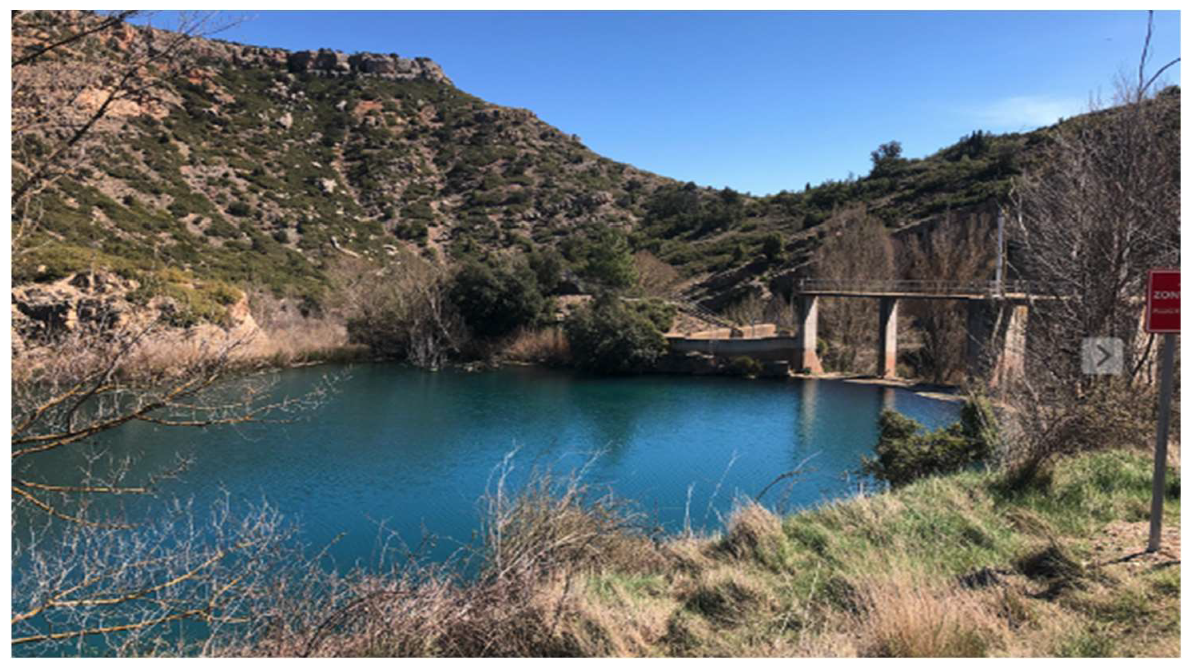
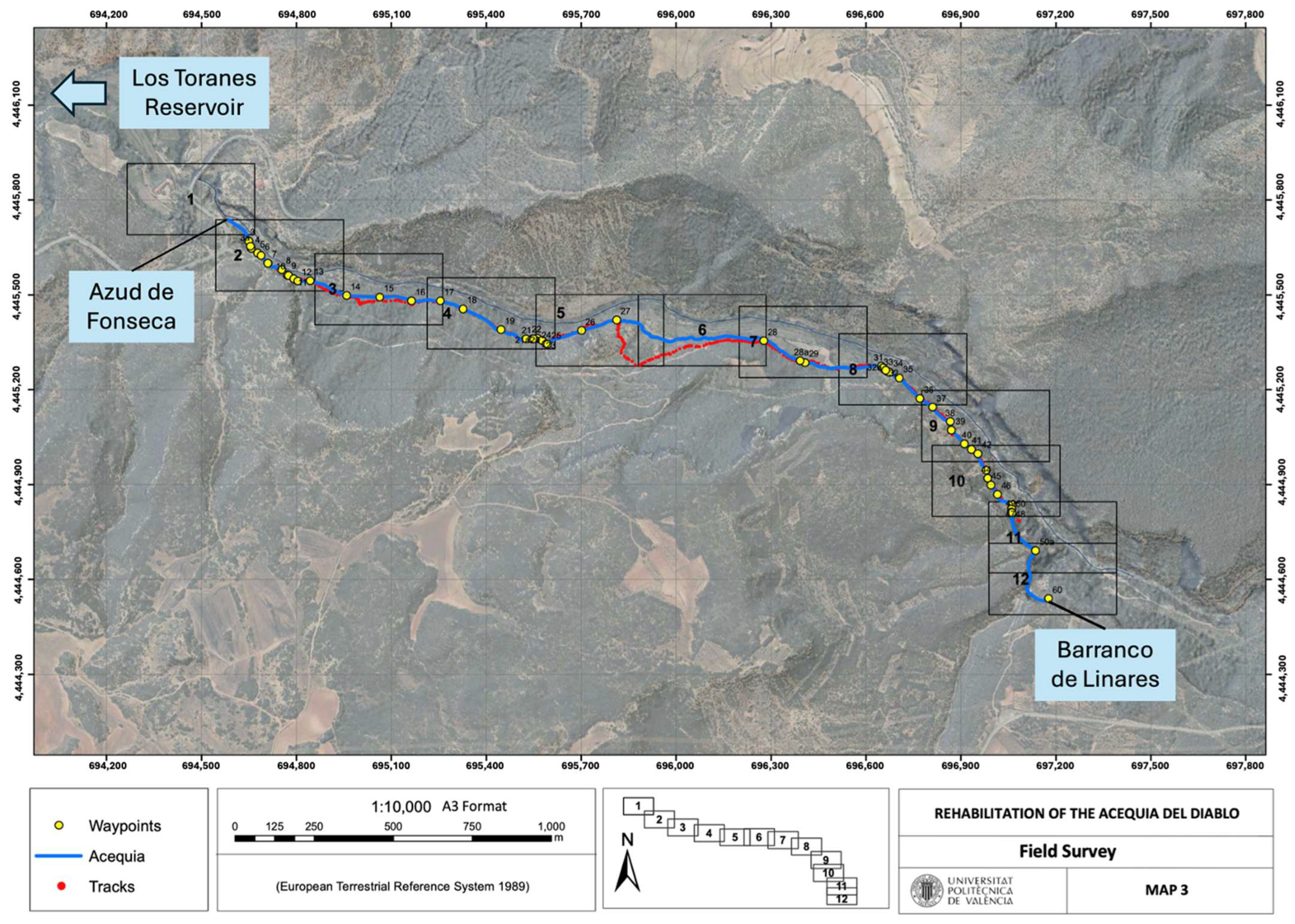
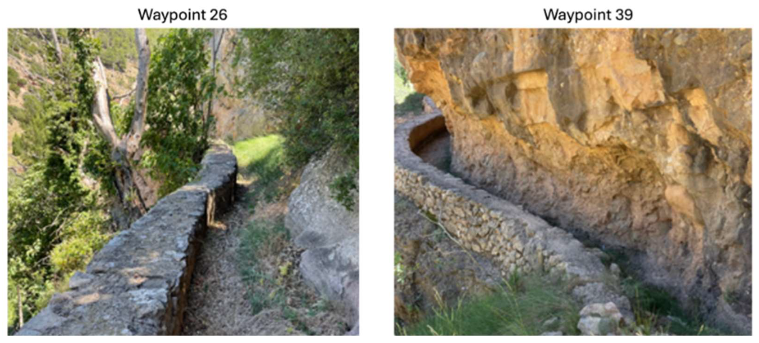
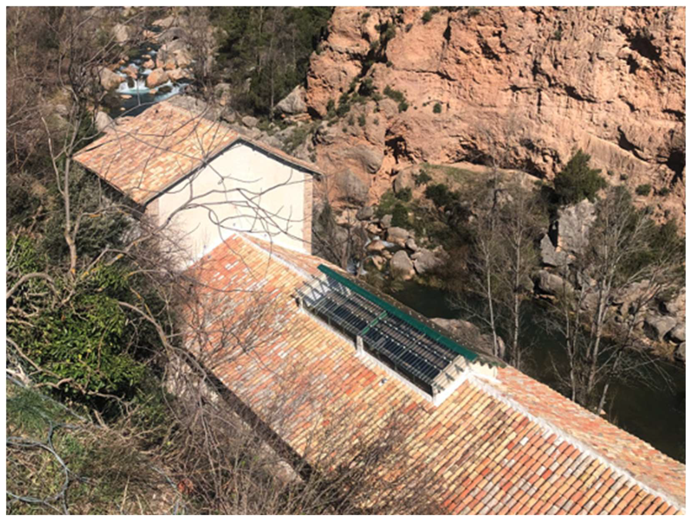

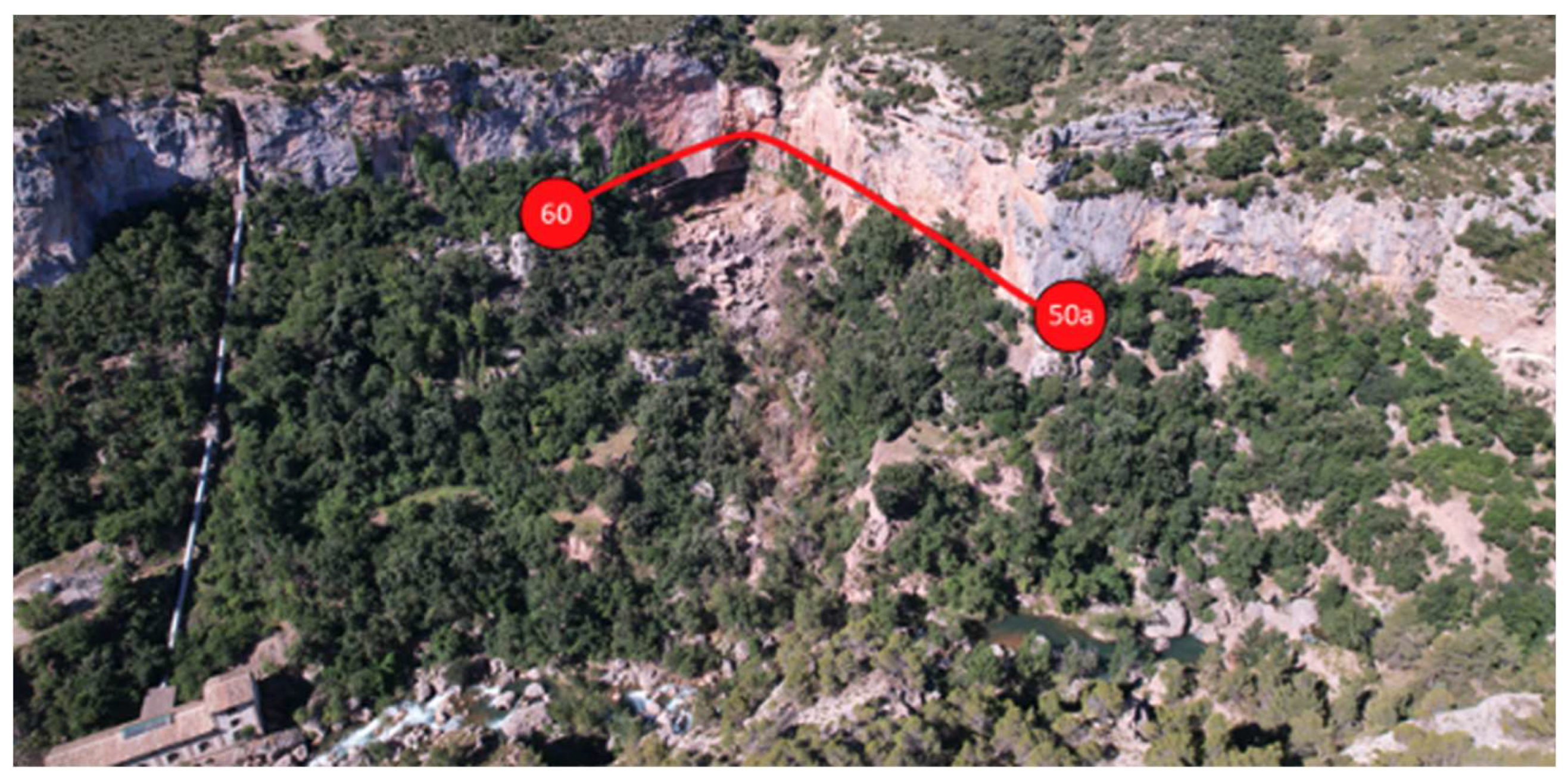
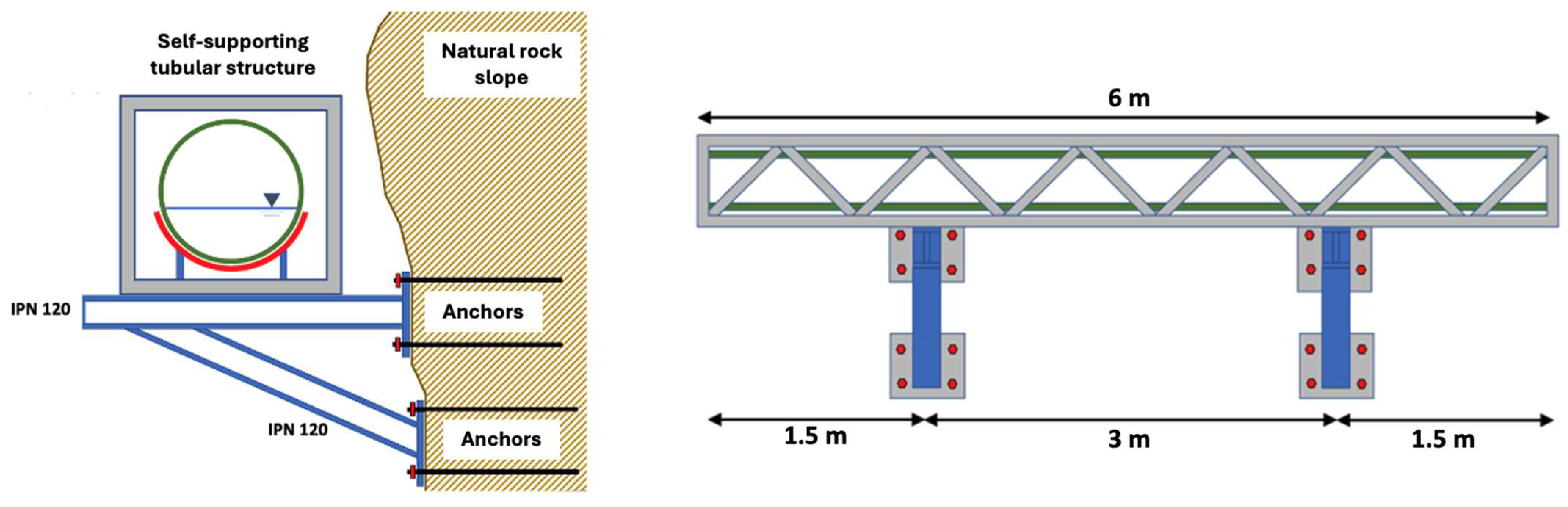
