1. Introduction
With the accelerating urbanization and industrialization in China, traditional villages—a spatial form that carries agricultural civilization and regional culture—are facing severe challenges. According to statistics, the number of natural villages decreased by 1.41 million between 1990 and 2020 [
1], including many traditional villages. Traditional villages not only embody rich historical, cultural, scientific, artistic, social, and economic values, but also hold unique potential for development as tourist destinations [
2,
3]. To protect and revitalize this resource, the Chinese government has implemented policies including the Beautiful Rural Construction and the Rural Revitalization Strategy. These policies aim to promote development through conservation, facilitating the sustainable utilization of villages’ traditional culture, natural landscape, and folk resources, transform them into “amenities” that can satisfy the diversified needs of tourists and enhance their experiences, and stimulate the economic potential and social vitality of villages. As things, environments, facilities, or services that can meet the diverse needs of tourists, amenities are an important part of the attractiveness of a place [
4], which is directly related to the overall tourism experience of tourists in traditional villages. Therefore, studying traditional village amenities from the perspective of tourists’ perception is of great significance to satisfy tourists’ needs and improve the quality of traditional village tourism and the sustainable development of traditional villages. “Tourist perception” refers to the subjective feelings and evaluations of tourists on all kinds of resources of traditional villages in the process of tourism, which is formed in the process of interaction between tourists and traditional villages, and not only reflects the objective existence of tourism resources, but also reflects the subjective preferences and needs of tourists.
The concept of rural amenities was born in the 1960s and 1970s: as the production value of the western countryside weakened, consumer values of aesthetics, leisure, and entertainment became prominent, and urban populations migrated to resource-rich and facility-convenient countryside for their living [
5,
6]. It not only refers to the quality, characteristics, goods, and services that can attract people to work and live [
7], but also covers the value development of rural ecology, production, life, culture, society, etc., emphasizing the importance of the countryside in the aesthetics, residence, leisure, recreation, and other consumer functions [
8], and can reflect the social, cultural, political, and economic phenomena of specific regions [
9]. Development based on rural amenities plays a significant role in promoting service industries such as tourism, pension, leisure, recreation, and health care [
10] and rural development [
11]. Its indicator evaluation system has become an important tool for enhancing the attractiveness and competitiveness of rural areas because it can effectively measure, compare, and analyze the level of systematic amenities and then explore the relationship between rural amenities and phenomena such as population mobility, well-being, and residents’ income. The rural amenities indicator evaluation system is mostly constructed from the perspective of single and comprehensive indicators [
12]. Single indicators: selecting a specific indicator to refer to rural amenities, such as Carlino [
13] and Roback [
14], taking sunshine as a characterization of rural amenities; comprehensive indicators: weighting multiple indicators to form an index of amenities, mainly focusing on nature, recreation, society, cultural, etc. [
4], e.g., Geo and Green divided 32 indicators into five amenities factors: climate, land area, watershed, outdoor recreation and history and culture [
7]. The construction of the above-mentioned indicator evaluation system primarily focuses on a Western context, emphasizing environmental protection and improvements in quality of life. However, given the differences between traditional Chinese villages and Western societies in terms of social structures, cultural backgrounds, and geographical environments, these evaluation index systems may not be fully applicable. Insufficient attention has been paid to the cultural–ecological–industrial–talent–organizational multidimensional amenity characteristics of traditional Chinese villages, which constrains the formulation of localized development strategies. The development of amenities in traditional Chinese villages not only pursues ecological and economic benefits but also seeks to integrate cultural heritage preservation, while emphasizing local factors such as organizational governance and talent cultivation. Therefore, to more accurately respond to the actual situation of Chinese rural villages and to fully take into account the rural revitalization and Chinese cultural context, there is an urgent need to construct a localized evaluation index system of amenities to reflect better the perceptions and needs of tourists in traditional villages, and thus to provide powerful support and guidance for the development of Chinese traditional villages.
In recent years, significant progress has been made in international research on rural amenities, particularly in improving the attractiveness and quality of life in rural areas in developed countries such as Europe, the United States and Australia. For example, Cortes Vazquez and Jose A explored the role of amenities in balancing community development and environmental protection in nature reserves during the economic crisis and the post-crisis period [
5]. Argent et al. further point out that amenities play a crucial role in enhancing regional competitiveness and attracting new populations during Australia’s rural regeneration process [
6]. As an interdisciplinary field of research, rural amenities research involves geography, sociology, economics, and other disciplines. The research theme focuses on population migration [
15,
16], rural development [
17,
18], quality of life [
19,
20], etc., and the research on the spatial distribution of rural amenities involves less research, which is specifically aimed at the spatial distribution of amenities of traditional villages in the perspective of tourists’ perceptions. There is even a lack of research on the spatial distribution of amenities in traditional villages from the perspective of tourist perception. In fact, the study of spatial distribution of amenities in traditional villages from the perspective of tourist perception can integrate the resources of amenities in traditional villages, improve the satisfaction of tourists in traditional villages, and provide a theoretical basis for promoting the development of tourism in traditional villages. Regarding the spatial distribution of amenities, existing research demonstrates notable limitations in both study subjects and scale. From the perspective of research objects, the focus is mainly on the spatial distribution of single amenities such as entertainment amenities, and community amenities. Östh et al. [
21] used spatial distribution data of recreational facilities to reveal that natural amenities exhibited greater attractiveness to tourists than cultural ones during the COVID-19 pandemic; Chin et al. [
22] employed community-level amenities to delineate urban functional zones. In terms of research scales, studies at the level of large regions such as countries and cities are predominant. Hu Shuang [
23] revealed the spatial heterogeneity and evolutionary patterns of urban amenities development in Chinese cities, identifying significant spatial autocorrelation characteristics. Ma Ling et al. [
24] evaluated the amenities index in major populated Chinese cities, revealing an uneven developmental pattern characterized by structural disparities among urban amenities. Naldi et al. [
25] combined the spatial distribution of natural and cultural amenities and found that amenities are a key determinant of the important factor in the rate of new business formation in rural and rural–remote areas in Sweden. Through a review of the literature, it is evident that rural tourism experiences are comprehensive and multidimensional [
26]. Analysis based on a single amenity may fail to comprehensively reflect the integrated amenity conditions of rural areas [
27]. To more accurately present the resource characteristics of traditional villages from the perspective of tourist perceptions, it is necessary to adopt multiple amenity indicators as research subjects and systematically explore their interrelationships as well as the spatial agglomeration characteristics. Moreover, since Chinese traditional villages are an important part of the rural revitalization strategy [
28], research on traditional villages from small regions can deepen the understanding of practical problems in rural development, such as rural quality of life, cultural preservation, industrial development, and ecological construction, which can help achieve the goals of the rural revitalization strategy and also complement the research on the national, urban, and other large-area levels [
2]. Based on this, this research takes 51 traditional villages in Jiaozuo City as the basic spatial unit. First, the Octopus software (v8. 7. 7. 032811) is used to collect the text of online travelogues about the 51 traditional villages in Jiaozuo City posted by tourists on Microblog and Douyin; second, the grounded theory method is used to construct a system of evaluation indexes of rural amenities in five dimensions of traditional villages, namely culture, ecology, industry, talent and organization, with a background of rural revitalization and Chinese culture; third, the location entropy and the spatial autocorrelation method are used to measure the spatial agglomeration and spatial agglomeration correlation of traditional villages amenities from the perspective of tourists’ perception; finally, gray correlation analysis is used to analyze the influence of factors including altitude, slope, distribution of water system, gross regional product, population density, distance to the county center, traffic conditions, and distance to scenic spots of grade 3A and above on the spatial agglomeration of amenities in traditional villages from tourists’ perceptual perspectives. Unlike previous studies that primarily focused on single-dimensional amenities and relied on traditional expert scoring methods, this research constructs a multi-dimensional amenity evaluation system from the perspective of tourist perception, aiming to better accommodate the unique needs of visitors towards traditional Chinese villages. Social media data can authentically reflect tourists’ perceived value of a place [
29]. This theoretical system not only focuses on ecological and economic benefits, but also emphasizes the key roles of cultural heritage, community vitality and talents in village development, which is particularly in line with the policy context of China’s rural revitalization. The results of the study not only provide countermeasure suggestions for resource planning, tourism development and social practices of traditional villages in Jiaozuo City, but also provide references for other similar traditional villages around the globe, and ultimately help to enhance the tourism attractiveness of traditional villages and tourist satisfaction.
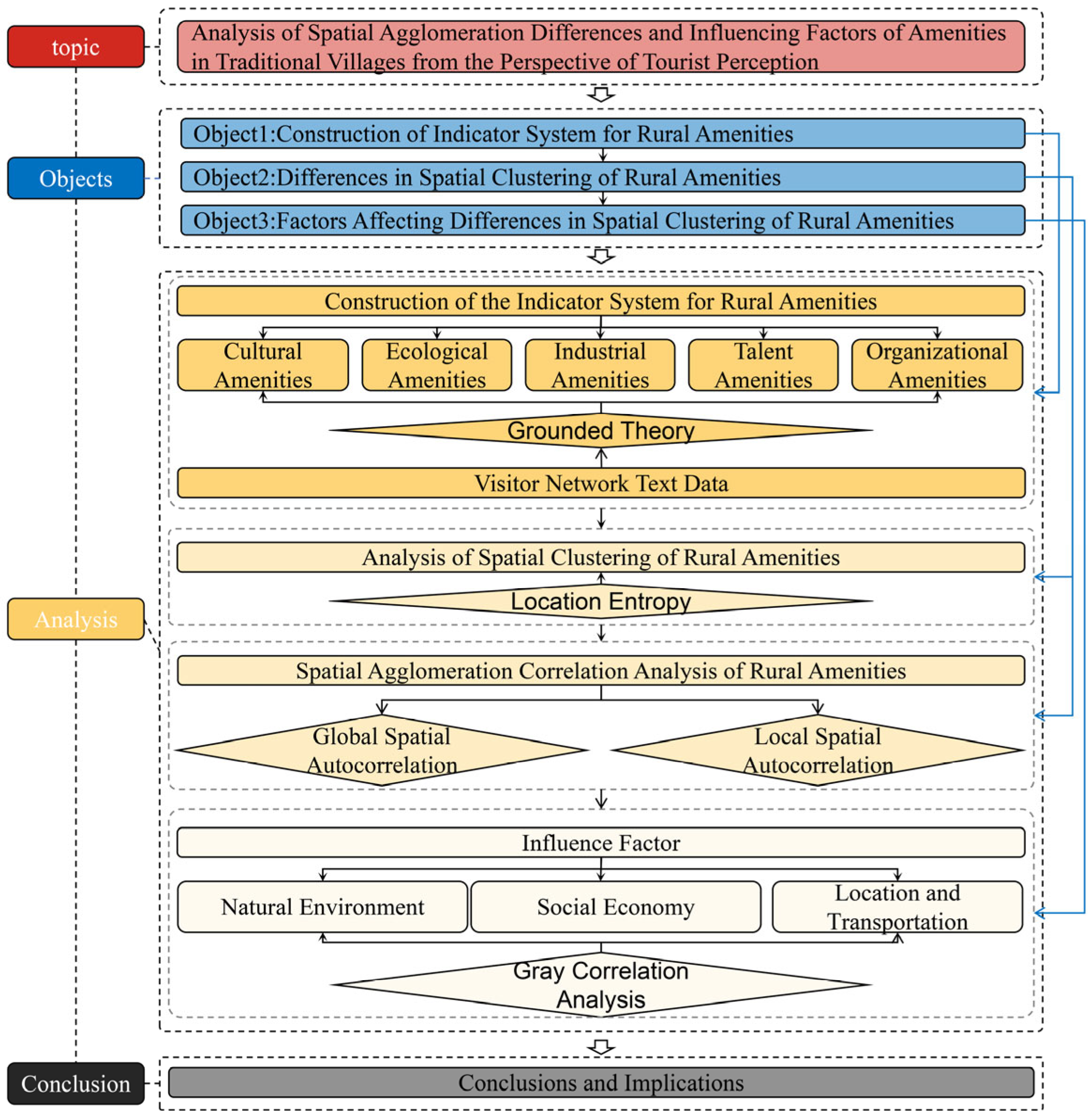
2. Materials and Methods
This study is based on the network text data of 51 traditional villages in Jiaozuo City, draws on the coding process of grounded theory to construct the evaluation index system of traditional village amenities, adopts location entropy, spatial autocorrelation, and gray correlation analysis to measure the differences in spatial agglomeration of traditional village amenities, synergistic effects, and their influencing factors, and provides countermeasures and suggestions for the tourism development of the traditional villages in Jiaozuo City based on the spatial agglomeration differences of traditional village amenities in the perspective of tourists’ perceptions. The research methods and ideas of this paper are shown in
Figure 1.
2.1. Study Area
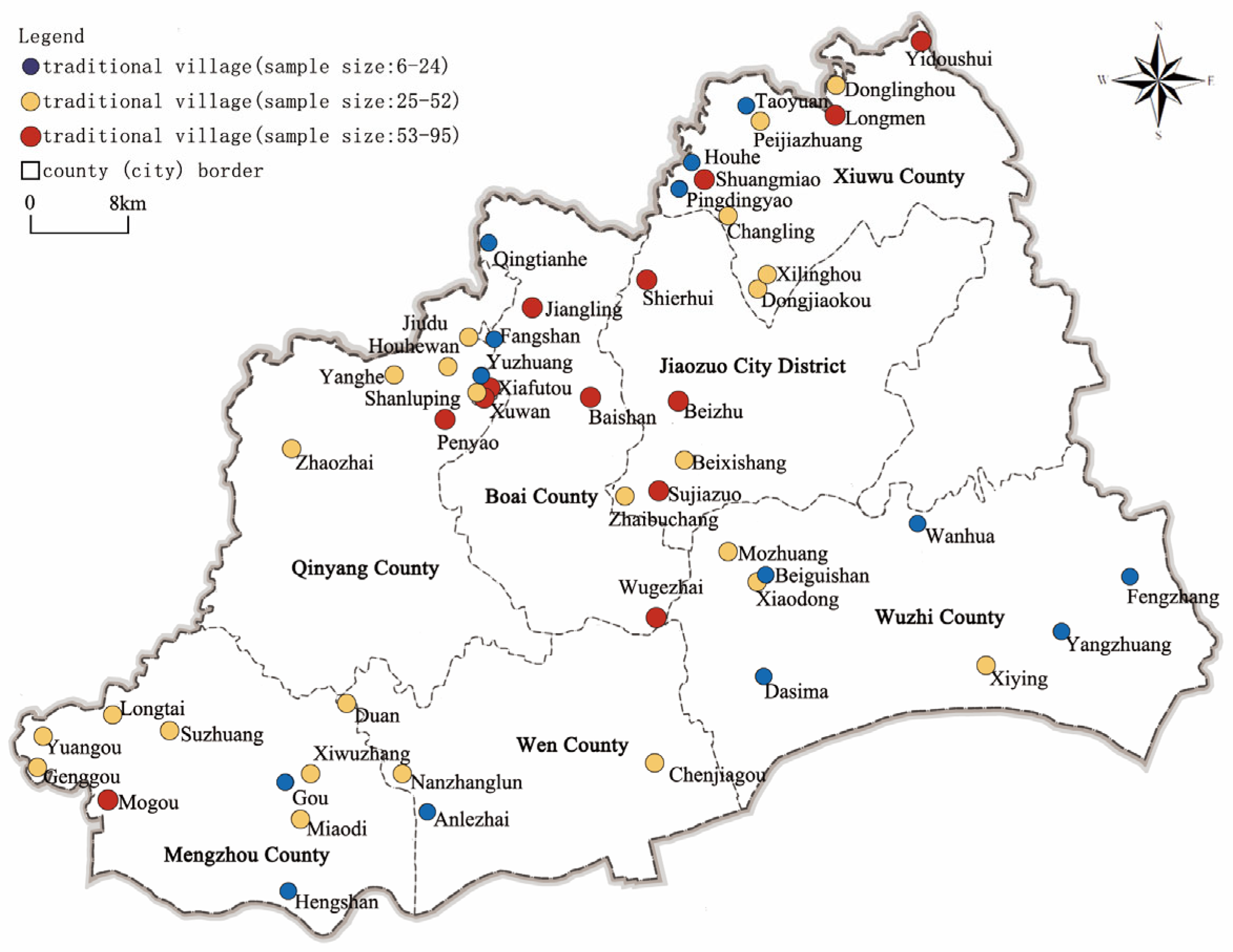
Jiaozuo City is located in the northwestern part of China’s Henan Province, with the Taihang Mountains in the north and the Yellow River in the south, and boasting abundant natural and cultural resources. As of 2022, there are 51 provincial-level traditional villages in Jiaozuo City, of which 11 are national-level traditional villages (
Figure 2). There are four main reasons for choosing Jiaozuo City as the study area: (1) Jiaozuo City is one of the important birthplaces of China’s Yellow River culture, and Wuzhi County within its borders, known as “the hometown of China’s Yellow River culture”, possesses profound Yellow River cultural deposits, and in-depth excavation of the value of the traditional villages in Jiaozuo City is of great significance to the promotion of high-quality development of the Yellow River Basin [
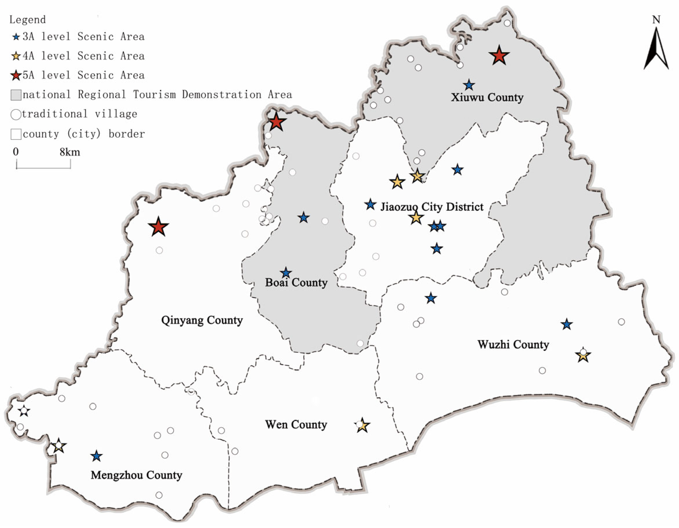
30]. (2) The magnificent natural landscape of the Taihang Mountainous Region and the long history and civilization of the Yellow River Basin provide rich rural tourism resources for the traditional villages in Jiaozuo City. At present, there are 2 traditional villages in Jiaozuo City which are rated as national 4A level scenic spots, 1 national 3A level scenic spot, 1 national 2A level scenic spot, 2 national key villages for rural tourism, 18 provincial rural tourism characteristic villages, 4 provincial rural recreation tourism demonstration villages, and another 9 traditional villages are located in national 5A level scenic spots, 19 are distributed in the national Regional Tourism Demonstration Area, and 16 are located in the Characteristic Eco-tourism Demonstration Towns of Henan Province, which fully reflect their advantages in tourism development and have high potential for tourism development (
Figure 3). (3) The traditional villages in Jiaozuo City fundamentally differ from rural communities in Europe and America in terms of cultural typology, developmental stages, and industrial integration models. They represent a complex synthesis of residential spaces, agricultural civilization, clan systems, and localized cultural sedimentation over extended periods. While western villages primarily emphasize natural landscapes and agrarian culture, Jiaozuo’s traditional villages integrate not only natural scenery but also a wealth of historical–cultural elements and industrial heritage. (4) The traditional villages in Jiaozuo City are a model of diversified rural tourism development, representing the tourism value and protection situation of many traditional villages. In recent years, with the similarity of tourism development positioning, random tourism development, and lack of scientific theoretical guidance, the traditional villages in Jiaozuo City are facing the problems of cultural inheritance rupture and ecological environment destruction, which are also common in the tourism development of other traditional villages.
2.2. Data Sources
The data of this study mainly include tourists’ online text data on Microblog and Douyin about the 51 traditional villages in Jiaozuo City, geospatial data, and socioeconomic data of Jiaozuo City. (1) Network text data. The Octopus tool was used to collect network text data about the 51 traditional villages in Jiaozuo City posted by tourists on Microblog and Douyin platforms, and after screening and organizing the data, excluding official releases, irrelevant to the research topic, and without substantive content, 2068 valid data points were finally collected, and the deadline for data collection was 14 February 2022. For the saturation of valid data, an additional 200 web texts published after 14 February 2022 were collected for validation. Microblog is one of China’s largest social media platforms with a broad user base, where users typically record travel experiences through images, text, and other forms. Douyin is China’s leading short video platform where users share travel experiences through videos, images, and text. These two platforms have the characteristics of extensiveness (massive user base), representativeness (mainstream tourists), and authenticity (spontaneously published content). Octopus Collector is a graphical web data collection tool that supports visual configuration of crawling paths, node recognition, pagination recognition, and other functions, suitable for complex webpage structures like Microblog and Douyin. The collection process includes entering keywords, setting page scrolling rules, identifying main text, and batch exporting to structured text formats. The reason for choosing online text data from Microblog and Douyin as sources of tourist perception data is mainly because such data can authentically record tourists’ first-hand travel experiences, with high spontaneity and subjectivity, effectively reflecting their genuine feelings when visiting traditional villages. Compared to traditional questionnaires or interviews, online text data has the advantages of large sample size, wide coverage, and diverse content, enabling the capture of subtle differences in tourist perceptions and compensating for sample limitations. (2) Geospatial data. The latitude and longitude coordinates of traditional villages were mainly obtained by using the Baidu map pickup coordinate system tool; the elevation and slope of Jiaozuo City were obtained from the geospatial data cloud; the distribution of the water system, the traffic conditions, the distance to the center of the county, and the distance to scenic spots of grade 3A and above (According to the attractiveness of tourist resources, the quality of tourist facilities and services, and the environment of scenic spots, China divides scenic spots into 5A, 4A, 3A, 2A and 1A grades. Grade 3A is the medium and above level of China’s tourist scenic spots. Distance to 3A and above scenic spots include 5A, 4A and 3A scenic spots, which have a more mature tourist reception capacity and a certain degree of tourist attractiveness compared to 2A and 1A scenic spots, and play an important role in the regional tourism market) were obtained from the National Center for Basic Geographic Information (NCBGI). (3) Socio-economic data. The gross regional product is from the 2015–2021 Jiaozuo City Statistical Yearbook, and the population density is from the 2022 China Population Census data.
2.3. Research Methodology
2.3.1. Grounded Theory
Grounded theory is a qualitative research method through systematic collection and analysis of information [
31]. It enables researchers to think and explore the interrelationships between things and their essential laws with a broader vision. The core lies in distilling theory from data, where continuous comparison and analysis progressively build explanatory concepts and theoretical frameworks. Given the current lack of mature indicator systems in the research field of traditional village amenities. In this paper, when constructing the evaluation system of traditional village amenities indicators from the perspective of tourists’ perception, we refer to the process of coding of grounded theory, including three key stages: open coding, axial coding, and selective coding [
32]. The rationale for grounded theory lies in its capacity to extract representative conceptual structures from complex, multidimensional perceptual data, thereby ensuring tight coupling between theoretically generated indicator systems and practical applications. It is particularly suitable for exploratory research in relatively new fields [
33].
2.3.2. Location Entropy
Location entropy is a method used to measure the distribution characteristics and degree of agglomeration of elements in space in a certain region, which can respond to the status and role of an element in a high-level region, etc. [
34]. This study primarily utilizes the frequency of amenities (reference points) to measure the spatial agglomeration characteristics of various amenities in Jiaozuo’s traditional villages from tourists’ perception perspectives, as well as to identify dominant amenities in specific villages. The main reason for choosing the locational entropy method is that it can effectively reveal the relative concentration of different amenities resources within the region, thus providing a quantitative basis for identifying the types of amenities with characteristics or potentials in traditional villages. Meanwhile, compared with other spatial analysis methods, the location entropy index is easy to calculate and intuitive to interpret, which is suitable for this study to characterize the distribution of amenities based on the perceived frequency of tourists. The calculation formula is as follows:
LQij is the value of locational entropy of class
i amenities in village
j,
Sij denotes the frequency of class
i amenities in village
j,
Sj denotes the total frequency of all amenities in village
j,
Si denotes the total frequency of class
i amenities in Jiaozuo City, and
S denotes the total frequency of all amenities in Jiaozuo City. When
LQij > 1, it represents that the
i amenities of village
j show agglomeration in Jiaozuo City and have a high dominance among the
i amenities of traditional villages in Jiaozuo City, and vice versa when
LQij < 1 [
35].
2.3.3. Global Spatial Autocorrelation
Global spatial autocorrelation is a method used to describe the spatial correlation of attribute values, which can be analyzed to determine whether they are clustered globally [
36]. This study employed the global Moran’s I index to measure the spatial agglomeration correlation of amenities in traditional villages in Jiaozuo City. The rationale for selecting this method lies in Jiaozuo’s numerous traditional villages exhibiting distinct spatial distribution patterns. Applying Global Moran’s I enables comprehensive characterization of amenity spatial distribution patterns across villages. The calculation formula is as follows:
xi and
xj are the entropy values of the location of traditional village amenities for
i and
j,
n is the number of study units,
wij is the spatial weight matrix, and
xy is the mean value of the location entropy of traditional village amenities. Moran’s I takes a value between [−1, 1]; if Moran’s I > 0, it indicates a positive spatial correlation, and the larger the value is, the more obvious the spatial correlation is; if Moran’s I < 0, it indicates a negative spatial correlation, and the smaller the value is, the larger the spatial difference is; if the index is close to 0, it indicates that an observation belongs to a random distribution spatially [
37].
2.3.4. Local Spatial Autocorrelation
Local spatial autocorrelation is a method that can solve the problem of global Moran’s I index, which is unable to explain the differences within the spatial autocorrelation of traditional village amenities [
38]. In this study, local spatial autocorrelation is used to analyze the correlation and similarity between local observations of cultural, ecological, industrial, talent, and organizational amenities and their neighboring observations from the perspective of tourists’ perception. The selection of this method is primarily based on two considerations. First, traditional villages exhibit strong spatial heterogeneity in their geographical distribution, resource endowments, and development levels, making global statistical methods inadequate for revealing amenity clustering and dispersion phenomena at micro scales. Second, from the perspective of tourist perception, local differences often have a more direct impact on visitor experiences, thus necessitating fine-grained spatial analysis methods for investigation. The calculation formula is as follows:
In Equation, If Ii > 0, it means that the local cells are spatially positively correlated; if Ii < 0, it means that the local cells are spatially negatively correlated.
2.3.5. Gray Correlation Analysis
Gray correlation is a multifactor statistical analysis method for data with small and irregular sample sizes [
39]. It is used to determine the strength and order of association between factors by comparing the degree of similarity between factors in a system and to find the important factors that affect the target. Tourists’ perception of the spatial agglomeration of traditional village amenities is affected by various factors and has complexity. Therefore, the gray correlation analysis method was selected to explore the relationship between the influencing factors and the spatial agglomeration degree of traditional village amenities from the perspective of tourists’ perception.
Step 1: Dimensionless processing. Standardize the reference and comparison series by applying the mean value method, noting
x0(
k) as the reference series and
xi(
k) as the comparison series.
Step 2: Calculate the gray correlation coefficient.
In the formula: ρ is the resolution factor, generally taken as 0.5.
Step 3: Calculate the gray correlation.
In the formula, ri is the gray correlation between the comparison sequence and the reference sequence, according to the correlation of the influencing factors for the size of the order, the larger the gray correlation, indicating that the higher the correlation between the two factors of the comparison sequence and the reference sequence.
4. Discussion
4.1. Reasons for Spatial Agglomeration of Amenities in Traditional Villages
The spatial agglomeration correlation analysis of traditional village amenities based on locational entropy reveals significant spatial autocorrelations among cultural, ecological, industrial, talent, and organizational amenities. This demonstrates strong clustering effects of these five dimensions of amenities at the traditional village level in Jiaozuo City, a phenomenon closely associated with China’s Rural Revitalization Strategy implementation. The strategy emphasizes an integrated development approach for traditional villages, requiring “connecting points into lines and expanding lines into clusters”. The traditional villages in Jiaozuo City have taken advantage of their geographic proximity, cultural commonalities, and industrial similarities to build a framework for overall development. In this process, these villages have not only demonstrated the characteristic “proximity-interactivity” relationship [
49], but have also developed a trend of “collaborative resource-sharing”, thereby achieving deep alignment with the objectives of the Rural Revitalization Strategy. For example, the traditional villages in Xiuwu County usually take advantage of the tourism resources of the Yuntai Mountain Scenic Area to promote the development of tourism industry; the traditional villages in Qinyang City and Boai County make use of the advantages of geographic resources to implement the overall planning and mutual sharing of resources; the Mogou Village in Mengzhou City builds a kiln culture and eco-tourism destination based on the characteristics of kiln caves; and the Chenjiagou Village in Wen County gives full play to its own unique charms in the culture of tai chi boxing, and builds a comprehensive tourism industry chain, covering tai chi boxing culture, and a comprehensive tourism industry chain. Chenjiagou Village in Wenxian County has built a comprehensive tourism industry chain covering taijiquan education and training, cultural tourism, health and wellness, etc. The traditional villages in Wuzhi County, based on their rich cultural heritage, promote the inheritance and development of the local culture by organizing various cultural and artistic activities. This development strategy not only improves the quality of life in the villages, but also contributes to the comprehensive promotion of the rural revitalization strategy, showing the vitality and charm of the traditional villages in Jiaozuo City in the context of the new era.
4.2. Suggestions for the Development of Traditional Villages
Research on the differences in spatial agglomeration of rural amenities in traditional villages from the perspective of tourist perception and the factors affecting the formation of differences can effectively provide a basis for decision-making on the development of tourism and resource integration in traditional villages in Jiaozuo City, and improve the attractiveness of traditional villages and tourist satisfaction. The study found that the spatial agglomeration correlation of rural amenities cultural, ecological, industrial, talent, and organizational amenities from the perspective of tourists’ perceptions were all characterized by spatial agglomeration, but the spatial autocorrelation of the non-significant type of traditional villages was more, so it is necessary to strengthen the spatial agglomeration characteristics of traditional villages’ amenities from the perspective of tourists’ perceptions. Firstly, to give full play to the synergy between the spatial agglomeration of ecological amenities and industrial amenities, it is recommended that, in formulating the development strategy for villages, the development of industries related to them should be enhanced through the protection and rational development of natural resources. At the same time, emphasis should be placed on supporting those villages with unique ecological resources, combining their ecological advantages with industrial development to form competitive specialty tourism products. This will not only help improve the overall attractiveness of the villages, but also help achieve sustainable growth of the village economy. Secondly, to strengthen the supporting role of organizational amenities, it is recommended to strengthen the organizational construction of traditional villages and enhance the capacity of traditional village governance and resource coordination. By guiding and supporting organizational construction in policy, traditional village organizations are given more resource management and coordination functions, thus enhancing the overall social cohesion and development efficiency of villages. Based on the results of the spatial agglomeration differences of traditional villages’ amenities from the perspective of tourists’ perceptions, this study proposes countermeasures to promote the development of traditional villages’ tourism and social practices from the perspectives of exerting agglomeration and radiation effects, synergistically promoting villages’ development, constructing the memory symbol system, and integrating the resource structural system as follows:
(1) Exerting agglomeration and radiation effects. Traditional villages with HH-type spatial agglomeration relevance of culture, ecology, industry, talents, and organizational amenities from the perspective of tourists’ perception have a certain foundation for tourism development. This type of traditional village should enhance the development of regional traditional villages according to their own conditions by strengthening infrastructure construction, traditional culture inheritance, and specialty industry development. At the same time, emphasis should be placed on distilling representative regional symbolic features to enhance cultural identity and tourism appeal. The radiation effect of the agglomeration area should be utilized to drive the development of the surrounding traditional villages, improve the scope of radiation, and form a contiguous protection and development trend.
(2) Synergistically promoting villages’ development. From the perspective of tourists’ perception, traditional villages with HL-type spatial agglomeration relevance of culture, ecology, industry, talents, and organizational amenities are mainly distributed around HH-type traditional villages. This type of traditional village should be combined with the strategic development direction of the agglomeration area, rationally adjust the development planning. Focus on establishing internal and external linkages with core area villages. While preserving their inherent advantages, these villages should explore and cultivate unique regional symbolic features, strengthen village branding and differentiated competitiveness, and collaboratively promote the integrated development of traditional villages within the region.
(3) Highlighting regional characteristics. From the perspective of tourist perception, traditional villages with LL-type spatial agglomeration of cultural, ecological, industrial, talent and organizational amenities show a contiguous distribution trend. These villages should leverage their geographical location and resource endowments to enhance their advantages and promote integrated development with other villages sharing similar characteristics. By establishing a regional memory symbol system with strong recognition and emotional value, they can strengthen cluster effects and enhance overall visibility and tourist appeal. Meanwhile, each village should be encouraged to develop distinctive local symbols based on its own features, rather than pursuing homogeneous development. This approach helps create complementary yet diversified tourism experiences within the contiguous development zone, achieving a balance between regional integration and preservation of village-specific characteristics.
(4) Integrating the resource structural system. From the perspective of tourists’ perception, the spatial agglomeration correlation of cultural, ecological, industrial, talent, and organizational amenities is NS-type and randomly distributed. These villages have the potential to optimize amenity allocation and enhance tourism experiences through resource integration. However, whether to pursue systematic development should be determined flexibly based on the village’s own resource conditions, community development aspirations, and relevant policy orientations. For villages with certain resource advantages and development willingness, measures such as optimizing amenity configuration, strengthening regional characteristics, and improving comprehensive service capabilities can be adopted to enhance visitor experiences and tourism competitiveness. For villages with limited resource endowments or high conservation value, priority should be given to non-development paths such as ecological protection and cultural preservation, avoiding the resource damage and cultural alienation caused by blind development. Meanwhile, NS-type villages, due to their lack of obvious spatial agglomeration phenomena, possess greater autonomy and flexibility in development. This provides local governments with more possibilities for differentiated development when implementing classified policies and place-specific rural revitalization strategies. The relatively independent spatial distribution characteristics of these villages offer more options for exploring diversified development models in the process of rural revitalization.
4.3. Contributions to Research, Limitations and Future Work
Compared with existing studies, the findings of this research demonstrate distinctiveness and innovation, which are reflected in both theoretical and practical contributions. Theoretical contributions: (1) A system of indicators for evaluating traditional amenities with rural revitalization and Chinese cultural background is constructed that is more in line with the actual situation of traditional villages in China. While international policies tend to emphasize environmental protection and quality of life, [
17,
20], China’s rural amenities policy focuses on the dual objectives of cultural and natural protection and economic development [
50]. Based on the research studies conducted in the West on the construction of amenities from the natural, social, and cultural perspectives [
4,
44], this article incorporates the “organizational amenities” and “talent amenities” contributed by the dual objectives into the assessment framework. This evaluation index system enriches the evaluation index system of rural amenities, and also provides a strong support for assessing and comparing the level of amenities in different rural areas. This responds to the call for multi-stakeholder participation in advancing sustainable development in rural areas [
51]. (2) Amenities. Existing studies have mainly focused on the spatial distribution of a single amenity or the spatial distribution of a particular amenity at the national or city level, such as public amenities, recreational amenities, urban amenities, etc. [
21,
22]. This study refines the clustering effect of amenities, explores the spatial distribution characteristics of multiple amenity indicators from the research scale of traditional villages. The study demonstrates a pronounced synergistic effect in the spatial agglomeration of ecological and industrial amenities, which resonates with the “industry-ecology symbiosis” framework established by Ren et al. (2024) [
52]. This research further delineate the specific manifestations and operational mechanisms of this synergy within the context of traditional Chinese villages, and explains the relationship between these dimensions of amenities spatially and the natural environment, socio-economics, and location and transportation from the perspective of tourists’ perceptions, which provides a more comprehensive perspective for understanding the distribution of rural amenities in traditional villages. Practical Contributions: (1) From a managerial perspective, this study proposes differentiated management and coordinated development strategies for traditional villages. Existing research has predominantly focused on holistic tourism resource development or single-factor improvements, with limited attention to tailored management approaches based on distinct spatial agglomeration patterns. By analyzing the spatial heterogeneity of amenity agglomeration under tourist perception, this study explicitly advocates for differentiated governance models aligned with specific agglomeration types (e.g., high–high, low–low, low–high, non-significant clusters). These findings not only enrich the theoretical framework for traditional village tourism resource management but also provide actionable insights for policymakers and local administrators in formulating rural revitalization and tourism development strategies. (2) From a practitioner perspective, this study offers strategies for optimizing products and services based on tourist perceptions. The ultimate goal of tourism experiences is the pursuit of happiness [
33]. Practitioners should thoroughly understand tourists’ perceptual preferences toward different types of amenities (cultural, ecological, industrial, talent, and organizational) [
53] and adopt location-specific approaches in product design and service innovation to create more compelling attractions [
54]. Additionally, emphasis should be placed on resident training and community participation to enhance rural hospitality services and tourism environment quality. By analyzing tourist perception data, practitioners can more accurately identify evolving demands, improve visitor satisfaction and destination competitiveness, and foster the sustainable development of traditional village tourism.
Although the article has achieved the above contributions, it also has the following limitations: (1) Diversity of influencing factors. Due to the availability of data, this study only explores the influencing factors of three dimensions: natural environment, location and transportation, and social economy. Although climate and policy may affect amenity agglomeration, these factors were not included in the current study due to the following considerations: (1) The regional scope of Jiaozuo is relatively small, with limited overall variation in climatic conditions, making it difficult to precisely match climate data to individual village-level scales. Future research could incorporate these variables at larger scales or with different data sources. (2) Policy factors (e.g., tourism support policies, traditional village conservation policies) are challenging to quantify and exhibit insignificant variation across the study area; in exploring the influence of gross regional product and population density on the spatial agglomeration of amenities in traditional villages, it only takes the GDP of counties in the period of 2015–2021 as the GDP of the village and the population density of the townships in 2022 as the population density of the village, lacking research on the individual gross regional products and population densities of the villages; tourists’ perception of traditional village amenities is also affected by multiple factors, such as tourists’ purpose of play, individual personality preferences and the spatial distribution of traditional villages in Jiaozuo City, and future research needs to improve and update these influencing factors. (2) Spatiotemporal dynamics of tourists’ perception. Tourists’ perception of traditional village amenities is a local spatiotemporal dynamic development process; future research should choose research samples with time series and analyze the spatiotemporal characteristics of traditional village amenities from the perspective of tourists’ perceptions from both temporal and spatial perspectives, synthesizing qualitative and quantitative analytical methods, to guide better the development of tourism in Jiaozuo City’s traditional villages. (3) Limitations of data sources. Social media data have problems such as unclear discussion topics and unclear tourist perception characteristics, and the data mainly reflect the perceived preferences of Chinese tourists and do not yet cover the perspectives of international tourists. There may be significant differences in the perception of traditional villages among different groups of tourists. In the future, we should expand the data sources, combine questionnaires, in-depth interviews, focus groups and other supplemental data to obtain more hierarchical and explanatory perceptual information, and introduce the analysis of tourists’ portraits, such as national boundaries, age, gender, and travel purpose, to further analyze the differences in perception and compare the cognitive differences among different groups of tourists in depth, so as to enhance the universality of the study and application value. (4) Limitations of research methods. Grounded theory heavily relies on subjective coding, potentially introducing researcher bias. Location quotient analysis, as a static method, cannot directly capture the dynamic processes of amenity agglomeration. Spatial autocorrelation analysis suffers from “edge effects”, potentially compromising the accuracy of spatial relationships for peripheral villages. Gray correlation analysis offers limited explanatory power for causality, merely indicating correlation strength.
5. Conclusions
This study takes the 51 traditional villages in Jiaozuo City as the research object, and relies on the basis of the concepts and classifications of amenities of scholars at home and abroad to further interpret the conceptual connotation of traditional village amenities. Firstly, we refer to the coding process of grounded theory to code the network text data of 51 traditional villages in Jiaozuo City on Microblog and Douyin, and construct the evaluation index system of traditional village amenities based on the five dimensions of culture, ecology, industry, talent, and organization of traditional villages under the perspective of tourists’ perception; secondly, we use location entropy and spatial autocorrelation to measure the degree of amenities concentration and spatial concentration correlation of traditional villages in Jiaozuo City from the perspective of tourists’ perceptions; lastly, we adopt the gray correlation degree analysis method to explore the factors affecting the spatial agglomeration of amenities in traditional villages from the perspective of tourists’ perception. The conclusions of the study are as follows:
(1) The differences in the locational entropy of the four types of amenities, namely, culture, ecology, industry, and organization, from the perspective of tourists’ perceptions are small, and the spatial distribution of the traditional villages in Jiaozuo City is more uniform, while the differences in the locational entropy values of talent amenities are large, and their spatial distribution is more concentrated in the traditional villages of Jiaozuo City.
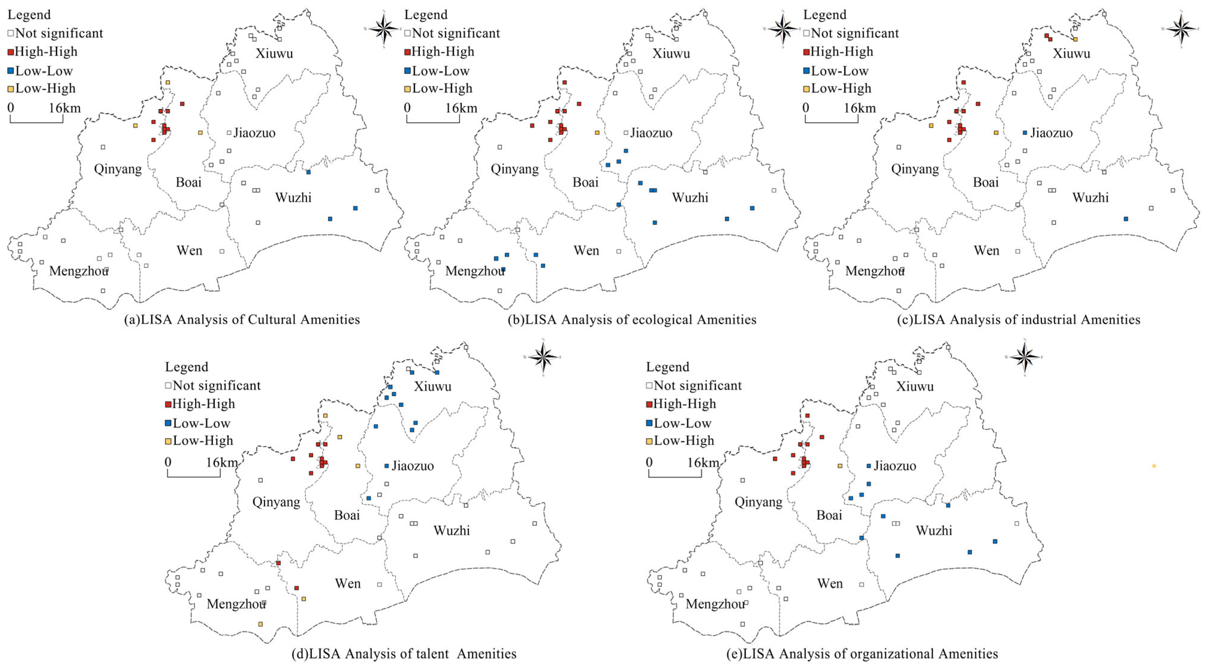
(2) Culture, ecology, industry, talent, and organizational amenities have strong positive spatial correlations from the perspective of tourists’ perceptions. The high–high type of culture, ecology, industry, talent, and organization amenities are distributed in a cluster, concentrated in Qinyang City and Boai County along the Danhe Canyon; the low–low type amenities tend to be distributed in a continuous manner, with the cultural amenities of low–low type mainly distributed in Mengzhou City, ecological amenities of low–low type mainly distributed in Wuzhi County, Jiaozuo Municipal Jurisdiction of Mengzhou City, and Wen County; the talents amenities of low-low type mainly distributed in Xiuwu County, and the organization amenities of low–low type mainly distributed in traditional villages in Jiaozuo Municipal Jurisdiction and Wen County. The low–low type of traditional villages is mainly distributed in Jiaozuo City District and Wen County; the low–high type is less distributed, mainly around the high–high type of traditional villages; there is a significant correlation between all the traditional village amenities spatial agglomeration, a significant synergy between ecological and industrial amenities spatial agglomeration, and organizations have a supportive role in promoting cultural, ecological, ecological and talent amenities spatial agglomeration.
(3) There are similarities and differences in the main factors affecting the spatial agglomeration of amenities in traditional villages from the perspective of tourists’ perceptions. Overall, gross regional product, slope, and distance to 3A and above scenic spots all play an important role in influencing the spatial agglomeration of amenities in traditional villages from the perspective of tourists’ perception.


