Article

Spatiotemporal Differentiation Characteristics and Zoning of Cultivated Land System Resilience in the Songnen Plain

1
Department of Land Resources Management, Northeast Agricultural University, Harbin 150030, China
2
Department of Computer Science and Technology, Northeast Agricultural University, Harbin 150030, China
*
Author to whom correspondence should be addressed.
Sustainability 2025, 17(10), 4314; https://doi.org/10.3390/su17104314
Submission received: 24 March 2025 / Revised: 6 May 2025 / Accepted: 7 May 2025 / Published: 9 May 2025
(This article belongs to the Special Issue Land Use Strategies for Sustainable Development)

Abstract

:
Enhancing cultivated land system resilience is a fundamental prerequisite for improving land use efficiency and thus addressing climate change. Taking the Songnen Plain—a major grain production area in China—as the study region, this study constructs a definition of cultivated land system resilience from three dimensions (“resistance–adaptability–reconstruction”). An index system for resilience evaluation is established, and methods such as three-dimensional Euclidean distance and K-means clustering are employed to investigate the spatiotemporal differentiation characteristics of cultivated land resilience in the Songnen Plain from 2001 to 2021. Based on the findings, zoning is performed and corresponding management strategies are proposed: (1) Overall resilience in the Songnen Plain increased from 0.4450 in 2001 to 0.7469 in 2021; enhanced resistance played the most significant role in promoting this increase. (2) The Songnen Plain exhibited pronounced spatial differentiation in cultivated land resilience, characterized by higher resilience in the eastern region and weaker resilience in the central and western regions. (3) The zoning results reveal significant disparities in resilience levels within the study area; targeted measures are thus required to address key problems in each zone. This study provides theoretical insights and empirical conclusions for formulating differentiated protection policies for cultivated land systems, thereby ensuring the sustainable development of the Songnen Plain’s cultivated land system.

1. Introduction

In the 21st century, intensified climate change and human activities have reshaped global cultivated land systems, leading to unprecedented pressures and challenges [1]. Studies have shown that problems such as soil quality degradation and biodiversity loss are becoming increasingly severe, posing serious threats to global food security and ecosystem services [2,3]. External disturbances, including extreme weather events and unsustainable land use practices, further exacerbate the vulnerability of cultivated land systems [4,5]. Traditional approaches to cultivated land management mainly target single issues—such as improving soil quality or mitigating land degradation—yet have proved insufficient in confronting the increasingly complex, dynamic, and multi-dimensional external disturbances. To address these challenges, the concept of resilience has emerged as a key framework for understanding how cultivated land systems resist external disturbances, adapt to environmental changes, and achieve a new equilibrium through transformation [6,7,8]. Resilience provides a fresh perspective on how land systems endure external pressures and maintain long-term productivity in the face of climate change and anthropogenic stress [9,10]. Consequently, resilience has gradually been acknowledged by the global scientific community and policymakers as a critical indicator for sustainable land management.
Located in Northeast China, the Songnen Plain is one of the country’s key agricultural production areas. However, it faces multiple challenges—including intensified climate change, land degradation, and urbanization pressures—which threaten the sustainability of agricultural production [11,12]. Hence, there is an urgent need for sustainable land management strategies and adaptive agricultural practices to bolster the resilience of farmland systems in this region and mitigate the pressures imposed by external disturbances.
Building on the above discussion and incorporating the processes that constitute resilience, this study examines cultivated land system resilience from the three dimensions of resistance, adaptability, and reconstruction. Using the Songnen Plain as a case study, we construct an evaluation index system for cultivated land system resilience, analyzing the system’s spatiotemporal evolution and regional differentiation in 2001, 2011, and 2021. This study aims to explore the impacts of modern economic and technological inputs on farmland utilization, offering fresh insights into how external risks can be managed and providing valuable references for sustainable farmland development. Such research is crucial for formulating effective management strategies, restoring and enhancing resilience, strengthening the capacity to withstand disturbances, and achieving the sustainable use of farmland resources—thereby ensuring the long-term sustainability of agricultural productivity, ecological stability, and land resources in the Songnen Plain.

2. The Evolution and Functional Mechanisms of Cultivated Land System Resilience

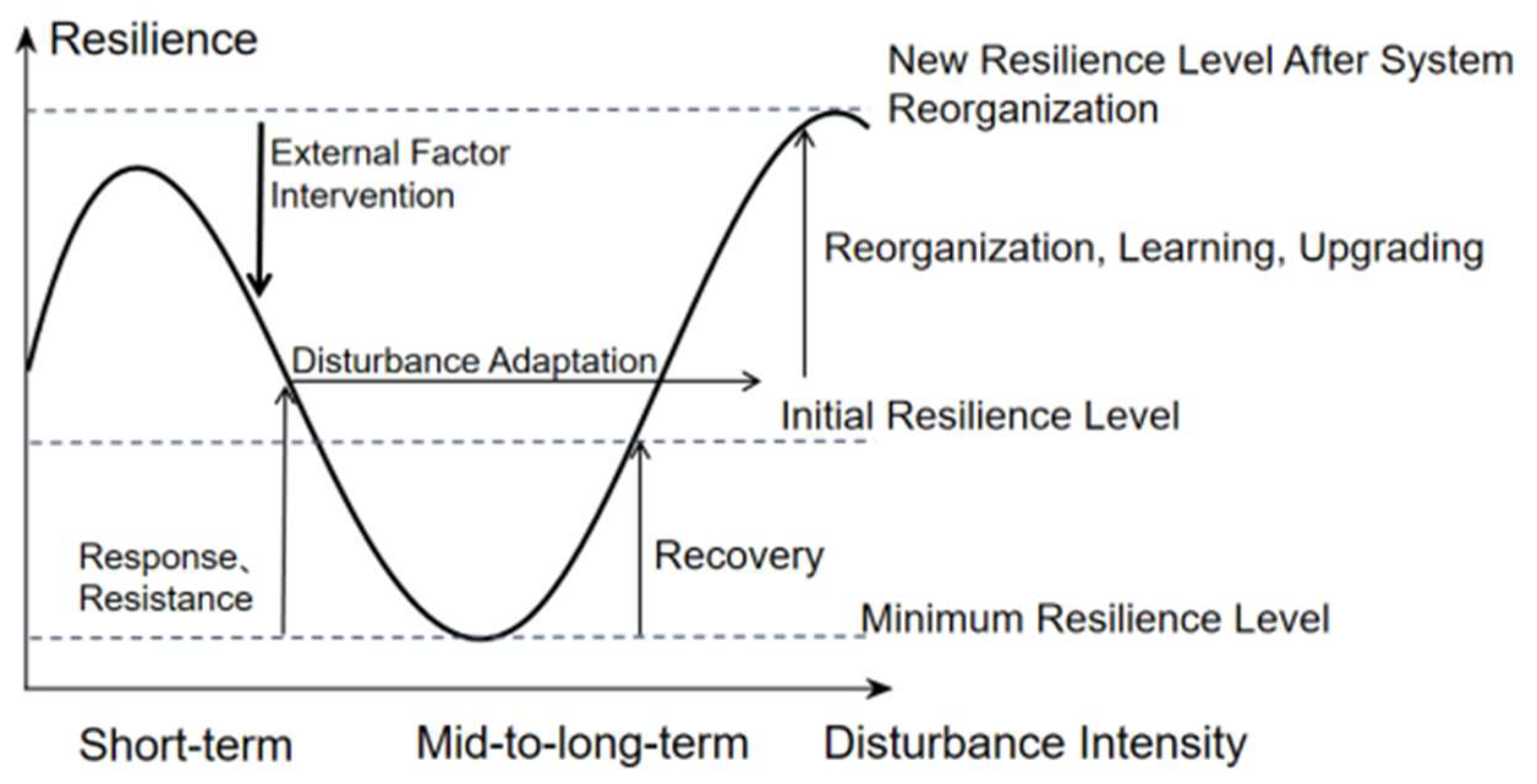
2.1. The Evolution of Cultivated Land System Resilience

Resilience theory has broadly undergone three developmental stages: engineering resilience (prior to 1973) [13,14], ecological resilience (from 1973 to the early 21st century) [15], and socio-ecological system (SES) resilience (from the early 21st century to the present) [16,17]. From the perspective of its origin, Holling [15] was the first to introduce the concept of “resilience” into the field of ecology in 1973, gradually shifting the focus toward the functional dynamics of ecosystems. In recent years, under the dual context of global climate change and sustainable development, resilience has evolved significantly and is increasingly recognized as a key attribute that enables systems to effectively respond to future uncertainties and potential shocks by adopting adaptive strategies. This evolution has integrated perspectives from ecology, economics, sociology, and other disciplines. The shift toward systems thinking and holistic analyses has not only deepened the theoretical understanding of resilience but also broadened its practical applications across various fields.
Currently, the incorporation of resilience theory into cultivated land system research remains limited. Existing studies on cultivated land—both domestic and international—have primarily focused on farmland quality [18,19,20], ecological security [21,22,23], and land use efficiency [24,25,26], emphasizing the external drivers of land system change, such as land use transition and climate impacts. However, they often overlook the self-regulating and disturbance-resistant capacities that farmland systems exhibit throughout their evolution [27,28]. In 2012, Zhao Huafu et al. [29] first introduced the concept of resilience into cultivated land research, highlighting the land system as an elastic body with self-organizing characteristics. In recent years, the number of studies on cultivated land use system resilience has gradually increased [30], though there is still no widely accepted or unified definition of its core connotation. From a methodological perspective, the main assessment approaches include the key variable method, composite index method, and participatory assessment [31,32]. Among them, the composite index method can be further classified into three categories: frameworks based on resilience functions [33], research subjects [34], and processes through which resilience occurs [35]. Regarding its core functional dimensions, beyond traditional functional analysis, recent research has expanded to cover the resource resilience, production resilience (PR), ecological resilience (ER), and structural resilience of cultivated land scale [30], as well as economic resilience (CR) [10]. The key roles of cultivated land system resilience lie in maintaining agricultural productivity, preserving ecological functions, coping with external disturbances, and enhancing long-term system stability and sustainability [36,37]. The evolution of cultivated land resilience theory—grounded in both resilience and sustainability science—has followed a trajectory from a single equilibrium to multi-feedback loops and adaptive cycles. It has since been widely extended to studies on ecosystem security [38], land security and thresholds [39], and agricultural resilience mechanisms [40], giving rise to derivative concepts such as agricultural resilience, land–ecology–economy resilience, and resilience indices [41,42]. Regarding indicator systems, scholars widely agree that the natural attributes of cultivated land, farming behaviors, and agricultural pollution all affect the use and protection of cultivated land [43,44]. Accordingly, multi-dimensional indicator systems based on the pressure–state–response (PSR) framework have been developed to evaluate cultivated land system resilience from multiple perspectives, such as the “functional structure–stability–redundancy–adaptive cycle” and “productivity–health–farming–use” [45,46].
Compared with the advances made in other fields, existing studies on cultivated land use system resilience lack analytical frameworks from a process-based perspective. Most resilience research has been conducted at the provincial [47] or municipal [48] scale, with relatively few studies focusing on the county-level, micro-scale units that are essential for the refined management and zoned regulation of cultivated land [49]. Moreover, there is a shortage of comprehensive studies that integrate resistance, adaptability, and reconstruction as internal dimensions of farmland system resilience. In regions subject to complex agricultural pressures—such as soil erosion, fertility loss, and socio-economic constraints—analyzing the resilience of the system is crucial for the formulation of effective land management strategies. To date, resilience research in fields such as engineering [50,51], urban systems [52,53], and ecosystems [54,55] has achieved substantial progress, offering valuable theoretical support for understanding and enhancing the resilience of farmland systems.

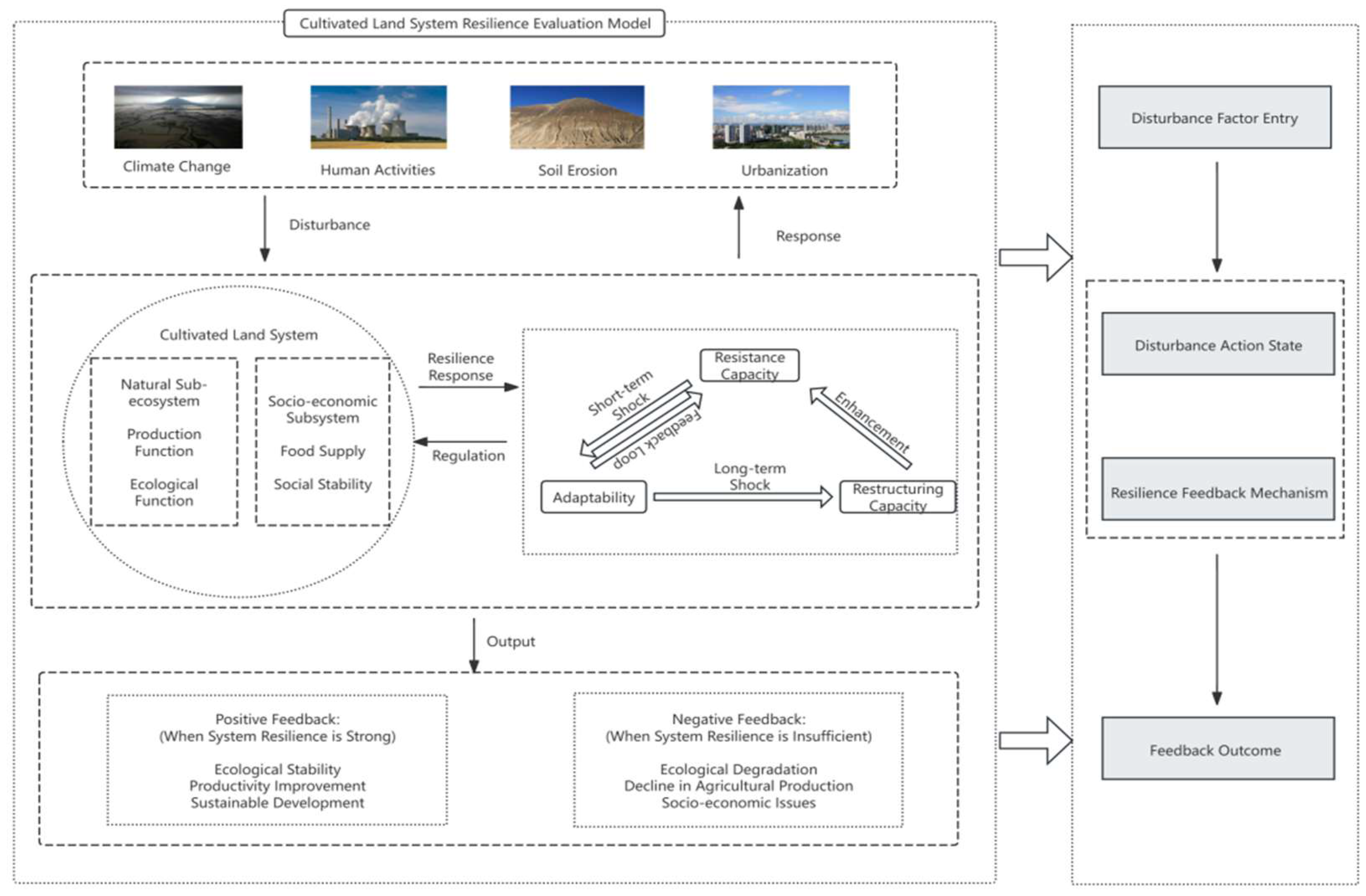
2.2. The Connotation and Mechanisms of Cultivated Land System Resilience

The cultivated land system is a semi-natural, human-modified system formed by human intervention in natural ecosystems to meet societal needs. It relies on land resources and utilizes crop growth and reproduction to produce agricultural products [56]. The use of cultivated land has evolved from traditional extensive agriculture, which heavily depended on natural resources, to a more technology-driven stage characterized by increased yields and environmental sustainability during the Green Revolution. This evolution reflects humanity’s ongoing exploration and improvement of agricultural production methods and land management concepts. Throughout this dynamic process, the cultivated land system itself has undergone structural adjustments to continually adapt to pressures arising from environmental, social, and economic changes, demonstrating its resilience.
By integrating theories from various disciplines, the resilience of a cultivated land system can be understood as its capacity to maintain core functions, recover quickly, and adapt to changes when facing natural, economic, or social disturbances. Applying resilience theory to cultivated land systems facilitates an analysis of their resilience evolution under external disturbances (Figure 1). When external disturbances such as climate change, human activities, and soil erosion occur, they directly or indirectly affect both the natural ecological and socio-economic subsystems. The core of the cultivated land system lies in the tight interconnection between its ecological and socio-economic components. The ecological system provides resources and ecosystem services that sustain food production and social stability, while external shocks disrupt these resources and functions, threatening system stability. To maintain stability and functionality, the system relies on three core resilience mechanisms: resistance, adaptability, and reconstruction.
Resistance refers to the system’s ability to withstand initial disturbances or pressures, preventing structural disorder and functional degradation [57]. This inherent capacity forms the foundation of cultivated land resilience. When the system faces long-term environmental or socio-economic pressures, adaptability comes into play. Through adjustments in management practices or production methods, the system can restore or enhance its functions. Adaptability thus supports and drives resilience; in the face of significant changes, the system may undergo deeper structural and functional transformations, leading to a new stable state in response to altered environmental conditions. This process, known as reconstruction, ensures the system’s resilience can be renewed and upgraded. These three mechanisms—resistance, adaptability, and reconstruction—interact within the system (Figure 2). When resistance is insufficient to withstand prolonged or severe impacts, the adaptability mechanism is triggered. By optimizing resource management or adjusting production methods, the system adapts to the changing environment, preserving functionality and even enhancing future resistance. If adaptability proves inadequate in response to strong disturbances, the system must undergo deeper reconstruction. Through this process, the system acquires new structures and functions, enhancing future resilience through positive feedback loops. However, frequent reconstructions may lead to increased vulnerability, creating negative feedback effects.

3. Materials and Methods

3.1. Overview of the Study Area

The Songnen Plain (119°52′–132°31′ E, 41°42′–51°38′ N) is located in Northeast China (see Figure 3) and comprises 64 counties (cities/districts), making it one of the largest plains in China. Renowned for its black soil resources, it is also a major production area for staple crops such as corn, rice, and soybeans. According to 2023 grain production data released by the National Bureau of Statistics, the Songnen Plain accounts for about 22.9% of China’s total grain output. Characterized by a temperate continental monsoon climate, the region has an annual average temperature ranging from 0 °C to 4 °C and an average annual precipitation of about 400–600 mm. Its terrain is generally flat, and the soil is highly fertile. The study area covers approximately 1.57 × 10⁴ km2 in total, with cultivated land amounting to 8.31 × 10⁴ km2—about 52.83% of the total area—encompassing the western hilly region, central lowlands, and eastern piedmont plain.

3.2. Data Sources

The socio-economic data utilized in this study were derived from statistical yearbooks and bulletins of Heilongjiang Province, Jilin Province, Harbin City, Daqing City, Qiqihar City, Suihua City, Heihe City, Changchun City, Baicheng City, Jilin City, and Songyuan City for the years 2001, 2011, and 2021. The land use data were obtained from the Resource and Environment Science Data Center of the Chinese Academy of Sciences (https://www.resdc.cn/DOI/ (accessed on 18 April 2025)). The net primary productivity (NPP) data were acquired from the MOD17A3HGF.006 dataset and aggregated spatially by county, based on the 2021 administrative division of China, using the mean value for statistical purposes. A 30-m Digital Elevation Model (DEM) was sourced from the ASTER Global Digital Elevation Model V003 dataset. The meteorological data were collected from the National Earth System Science Data Center, specifically the China Temperature and Precipitation Dataset with a 1 km spatial resolution covering 2000–2020 (http://www.geodata.cn/ (accessed on 18 April 2025)) (Table 1). To address adjustments made to certain county or district names, this study standardized the county/district names from 2010 to match those of 2021 based on administrative boundaries and name-change references, facilitating a comparative analysis. To ensure data integrity, district-level administrative units within each prefecture-level city were merged. Missing values for specific years or regions were filled using adjacent values or linear interpolation methods.

3.3. Research Methods

3.3.1. Development of the Cultivated Land System Resilience Evaluation Framework

To effectively measure the resilience of cultivated land systems, this study constructs a comprehensive indicator system that integrates multiple dimensions, including economic, technological, productive, and ecological factors. Resistance is evaluated through environmental indicators such as precipitation and net primary productivity (NPP), adaptability is measured using socio-economic variables such as agricultural output, and reconstruction is quantified by technical and structural indicators such as vegetation cover and mechanization level. This multi-dimensional approach reflects the inherent complexity of resilience and provides a framework to better understand how cultivated land systems respond to dynamic pressures (Table 2).
In addition, the Stata 15.0 software platform was used to standardize the raw data to eliminate differences in measurement units and ensure that all indicators could be compared and weighted on a common scale. Since the traditional entropy weight method may produce biased results when the entropy value approaches 1—leading to disproportionately small weights for certain indicators with low variation—this study applies an improved entropy weighting method (see Equations (1)–(7)) to calculate the weight coefficients shown in Table 1, resulting in a more reasonable and scientifically grounded distribution of weights. This modification makes the weight distribution more reasonable and avoids distortion under specific conditions, thereby ensuring that the weight coefficients are more accurate and scientifically grounded. The final indicator weights used in the evaluation are presented in Table 1. This framework facilitates a robust and integrated assessment of the overall resilience of the cultivated land system.

3.3.2. Improved Entropy Weight Method

To scientifically and objectively determine the weights of each indicator, this study employs the entropy weight method as a weighting tool. By standardizing the raw data, the information entropy and redundancy for each indicator can be calculated, thus reflecting the indicator’s importance in the comprehensive assessment. Additionally, to address the distortion in weight allocation that arises when the entropy value is close to 1 in the conventional entropy weight method, this study introduces an improved formula to optimize weight allocation, making the results more reasonable and accurate [58].
Q ij = x i j min ( x i j ) max ( x i j ) min ( x i j )
Q ij = max ( x i j ) x i j max ( x i j ) min ( x i j )
P i j = x i j i = 1 n x i j
e i = l ln n i = 1 n P i j ln P i j
f i = 1 e i
W i j = f i j = 1 m f i
where Qij represents the standardized values derived from the original data; the maximum value of the original data is denoted by max(x1j, x2j, x3j, …, xnj); t represents the number of years; n indicates the number of counties (or districts); m is the number of evaluation indicators; xij represents the numerical value of the jth evaluation indicator for the ith county (or district) (i = 1, 2, …, n; j = 1, 2, …, m); and Wij denotes the weights of indicators.
However, determining indicator weights using Equation (6) presents certain limitations: when the entropy ei approaches 1, even slight differences can significantly alter the indicator weight Wi [59]. Examples illustrating the limitations of the traditional entropy weight method are shown in Table 3.
W i j = ( 1 e ¯ 35.35 ) f i i = 1 m f i + e ¯ 35.35 1 + e ¯ e j k = 1 , e k 1 m ( 1 + e ¯ e k )                         e j < 1 0                         e j = 1
where e ¯ denotes the average of all entropy values that are not equal to 1.

3.3.3. Three-Dimensional Euclidean Distance

Three-dimensional Euclidean distance is a commonly used spatial distance measure in multivariate analysis [60]. It requires converting observations into standardized three-dimensional coordinates. By combining the values of the “resistance–adaptability–reconstruction” dimensions into a single distance measure, it comprehensively assesses and quantifies differences in resilience among regions, reflecting the temporal and spatial changes across all dimensions and helping reveal the overall dynamic evolution of resilience. The strength of cultivated land system resilience is therefore characterized using three-dimensional Euclidean distance. The cultivated land system resilience measurement model is expressed as follows:
l = W * Q
V = ( l 1 2 + l 2 2 + l 3 2 )
where V represents the resilience value of the cultivated land system, and l1, l2, and l3 represent resistance, adaptability, and reconstruction values, respectively.

3.3.4. Kernel Density Estimation

Kernel density estimation is a commonly used non-parametric method for estimating the density function of data points [61]. In this study, kernel density estimation is applied to identify temporal distribution patterns of cultivated land system resilience in the Songnen Plain. By calculating the density of points in different regions, the temporal evolution of resilience can be visualized more intuitively. The kernel density function is expressed as follows:
f ( x ) = 1 n h i = 1 n K ( x x i h )
where f(x) represents the kernel density estimate at point x; n represents the number of samples; h is the bandwidth (smoothing parameter), determining the width of the kernel function; K denotes the kernel function; and xi is the ith sample point.

3.3.5. K-Means Clustering

K-means clustering is a widely used unsupervised learning algorithm that divides datasets into k distinct clusters [62]. Data points within each cluster are highly similar to each other and exhibit notable differences from points in other clusters. The algorithm classifies data by minimizing the distance between the data points and their corresponding cluster centroids. By grouping counties based on their resilience characteristics, the algorithm helps identify regions with similar resilience patterns and highlight key areas for targeted management and intervention. This approach enables a more nuanced understanding of regional variations in cultivated land resilience and supports the development of tailored strategies for sustainable land use.
s ( c , m 1 , m 2 , m 3 . . m p ) = z = 1 p x z m c ( p ) 2
c i = a r g m i n j e ( 1 , 2 j ) x i m i , i N n
m p = 1 n p c ( i ) = p x i , p N p
x y = i = 1 q ( x i y i ) 2
where z denotes the index of a data point; p represents the total number of clusters (the K-value); Xz indicates the zth data point; mc(p) denotes the centroid of the pth cluster; x and y represent two data points; q refers to the dimension of the data; xi and yi are the coordinates of the ith dimension; Ci denotes the cluster number to which the ith data point belongs; “argmin” represents finding the index that minimizes the objective function; specifically, each data point xi is assigned to its nearest centroid mj, where j is the cluster number (from 1 to j); N denotes the set of all data points within the dataset; np indicates the total number of data points belonging to the pth cluster (cluster size); c(i) refers to data points belonging to the pth cluster; pi represents the coordinate values of each data point in the pth cluster; and Np denotes the set of all clusters.

4. Results

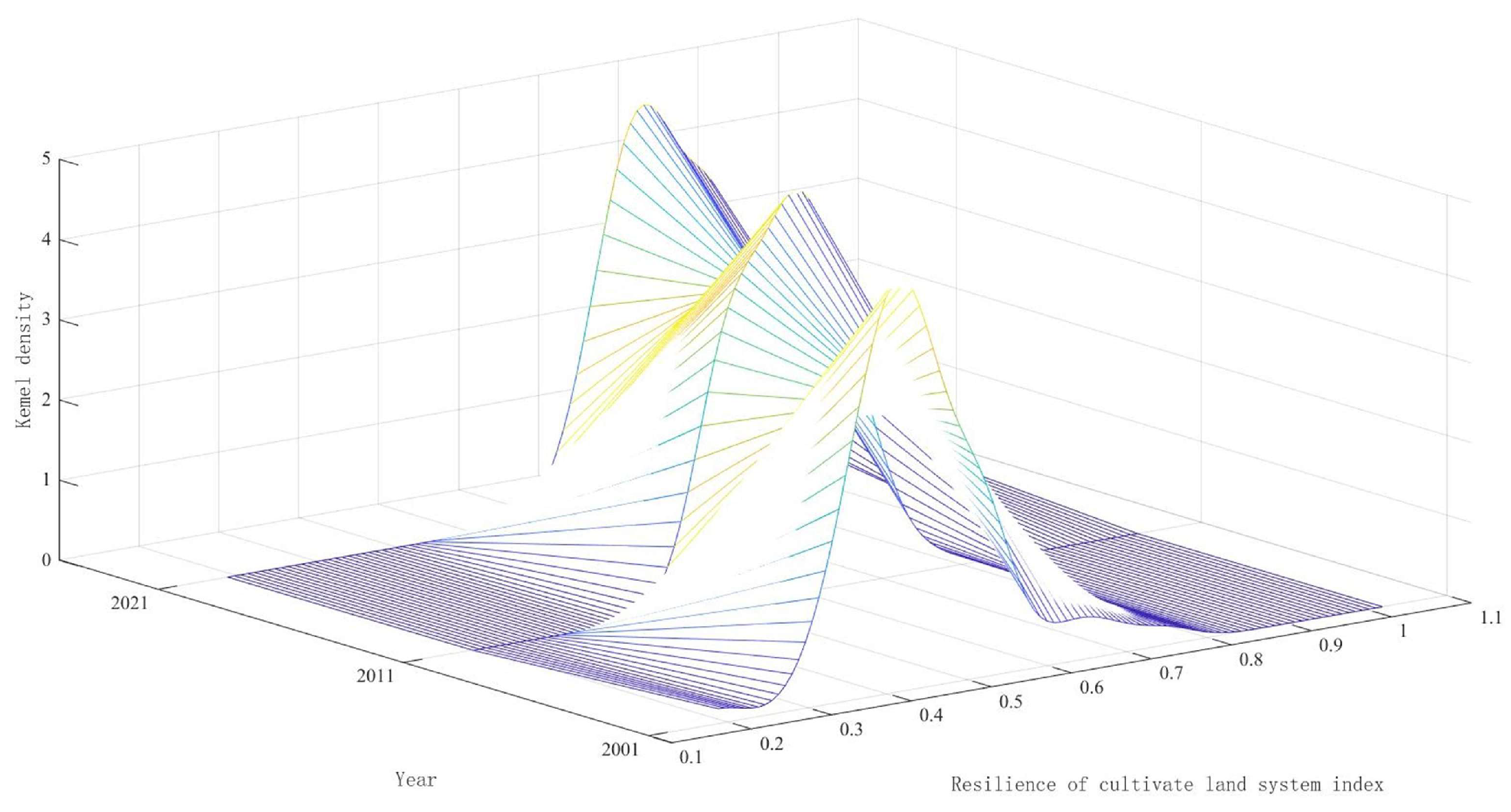
4.1. Spatiotemporal Differentiation Characteristics of Overall Cultivated Land System Resilience in the Study Area

Overall, the cultivated land system resilience in the study area exhibited a significant upward trend from 2001 to 2021. The resilience improved by 0.027 more notably during the period from 2011 to 2021 compared with from 2001 to 2011. However, the overall resilience level was moderate to high, indicating room for further improvement. A comparison between the resilience indices from 2001 to 2011 and from 2011 to 2021 reveals that resilience enhancement was more pronounced in the latter decade (Figure 4).
Analyzed using different dimensions, the resistance, adaptability, and reconstruction of the cultivated land system in the Songnen Plain all demonstrated varying degrees of enhancement between 2001 and 2021. Ranked by their intensity of contribution from lowest to highest, the dimensions were adaptability (0.1525–0.2427), reconstruction (0.2627–0.3297), and resistance (0.2968–0.3828). Ranked by their magnitude of increase from highest to lowest, they were resistance (0.2652), adaptability (0.1331), and reconstruction (0.1112).
These findings indicate that the study area’s cultivated land possesses a relatively strong natural baseline and favorable external conditions, enabling the system to remain stable and effectively resist environmental pressures and external shocks. The adaptability indicator exhibited a steady upward trend but with a relatively small increase, suggesting weaker socio-economic influence, insufficient agricultural management capacity, and limited ecological recovery ability, resulting in lower resilience to environmental dynamics and slower recovery after disturbances. Notably, enhanced resistance was identified as the primary contributor to improvements in cultivated land system resilience, followed by adaptability and reconstruction.
Using the natural breaks method in ArcGIS 10.8, cultivated land resilience was classified into five levels: low, relatively low, medium, relatively high, and high. To clearly illustrate temporal changes in cultivated land system resilience across the Songnen Plain, kernel density curves were employed. The cultivated land system in the Songnen Plain exhibited significant changes over time: In 2001, most regions had medium resilience or below, with low and relatively low resilience concentrated primarily in the central and southern regions. By 2011, the overall resilience level improved notably, with the proportion of areas classified as low and relatively low resilience, decreasing from 92% to 35%, while areas with medium and relatively high resilience expanded from 8% to 65%, indicating substantial improvements in the central and northern regions. By 2021, low and relatively low resilience levels were observed only in a few counties, signifying a significant improvement in cultivated land resilience across most of the study area. Medium and relatively high resilience became predominant, especially in the central and northern regions, reflecting sustained progress in agricultural management, technological application, and ecological restoration. Additionally, some regions attained high resilience levels.
As shown in Figure 5, the kernel density distribution for the entire Songnen Plain shifted rightward, suggesting an overall slow upward trend in resilience. The kernel density curve’s width expanded from the range of 0.2–0.6 in 2001 to 0.5–0.9 in 2021, indicating an increasingly concentrated distribution of resilience levels and reflecting the overall enhancement in resilience. However, differences in resilience levels between regions also intensified, highlighting increasing unevenness and spatial differentiation. Peaks continually shifted to the right, regional differences became more pronounced, and resilience distributions became more uniform.
Specifically, in 2001, the resilience index distribution was relatively concentrated within a lower resilience range (0.3–0.5), indicating weak resistance, adaptability, and reconstruction capacities. By 2011, the region with higher kernel density values expanded toward higher resilience values (0.5–0.7), peaking around 0.6. This improvement signifies that agricultural management practices and policies effectively enhanced the adaptability and reconstruction capabilities of the cultivated land system. In 2021, high-density values further shifted toward the range of 0.6–0.8, although the peak height decreased slightly, suggesting a slowdown in resilience improvement. This slowdown aligns with new challenges and increased environmental pressures associated with recent economic development in the Songnen Plain.

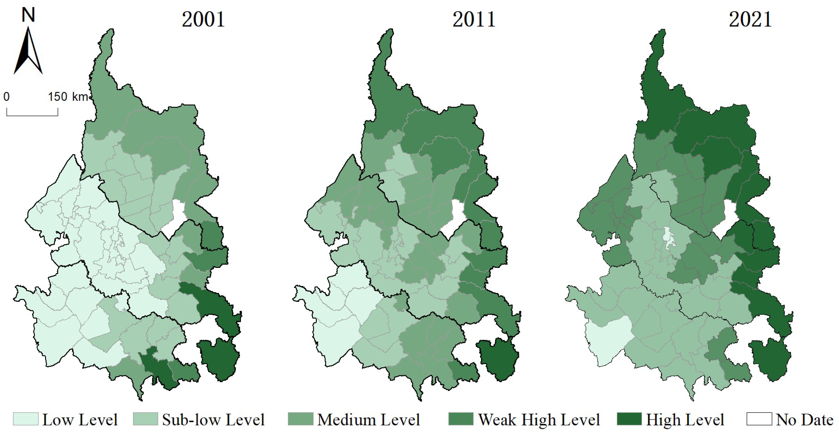
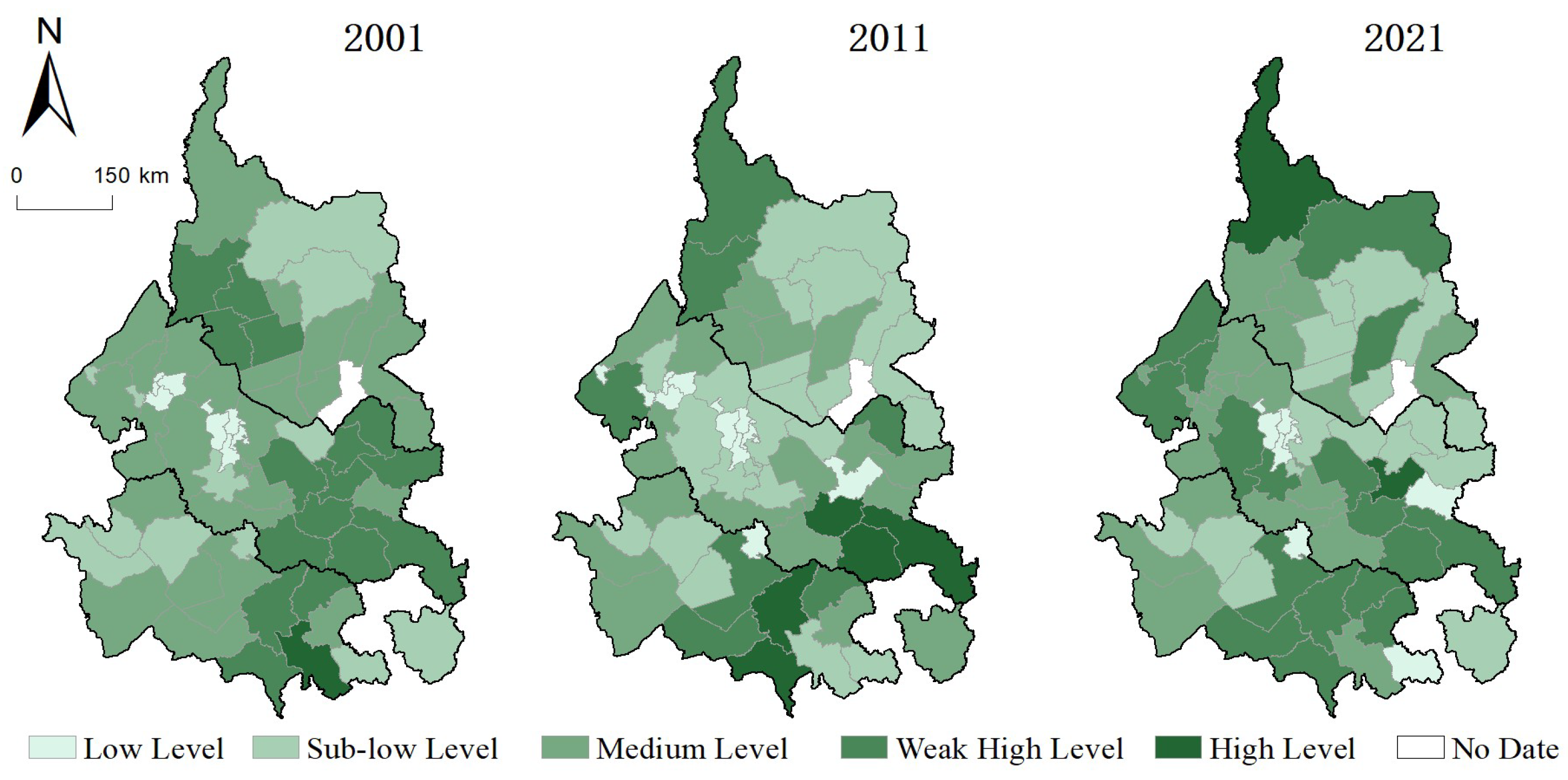
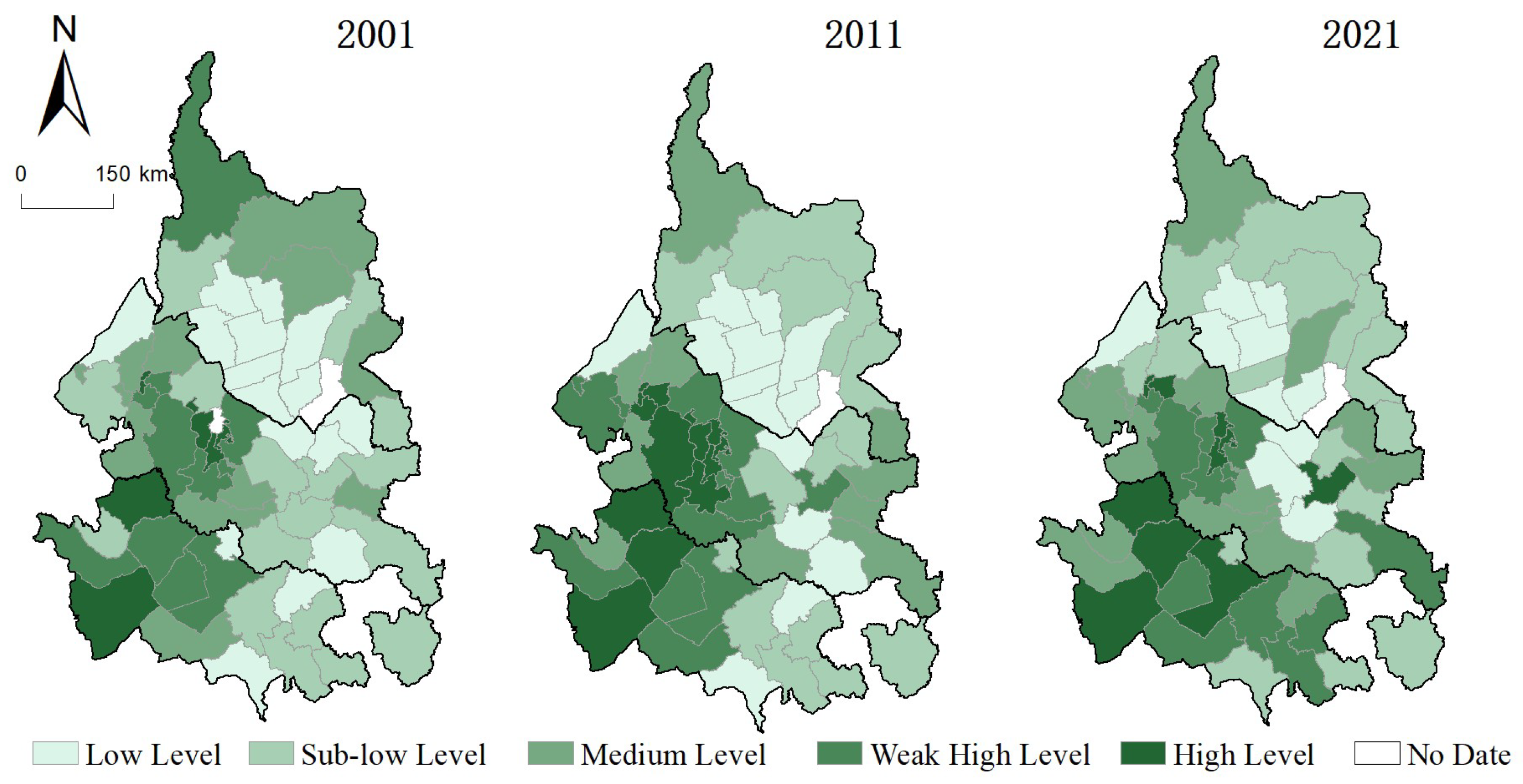
4.2. Spatiotemporal Differentiation of Cultivated Land System Resilience at the County Level

By comparing the dynamic changes in resistance, adaptability, reconstruction, and overall cultivated land system resilience across counties in the study area during the three periods (2001, 2011, and 2021), the resilience levels and characteristics of each county can be clearly identified (Figure 6).
From the perspective of resilience levels, Wuchang City consistently maintained high cultivated land system resilience from 2001 to 2021. Specifically, Wuchang ranked fourth (0.6405) in 2001, first (0.7582) in 2011, and third (0.9389) in 2021, making it the county-level city with the highest overall resilience. This superior resilience primarily stems from its advantageous geographic location, characterized by a mild climate and fertile black soil, which significantly promotes agricultural productivity. Additionally, during the study period, Wuchang City actively integrated agriculture with technological innovation, promoted technological advancements in agriculture, expanded green and organic crop cultivation, implemented black soil conservation practices, encouraged eco-friendly and sustainable circular agriculture, and developed demonstration bases for standardized agricultural production. These modern practices greatly enhanced the city’s ability to resist environmental disturbances, adapt effectively to external changes, and reconstruct its cultivated land system after experiencing disturbances.
In contrast, Ningjiang District exhibited consistently low resilience throughout the study period, ranking at the lowest resilience level in all evaluated years. Ningjiang District is located in the transitional zone between semi-arid and semi-humid climates, marked by unique climatic conditions and pronounced topographical differences caused by neotectonic movements and erosion from the Songhua River. Additionally, due to atmospheric pressure patterns and wind-tunnel effects from the terrain of the Songliao Plain, the region frequently experiences strong southwest winds, resulting in severe soil erosion. These natural factors weaken the district’s resistance, making its cultivated land system particularly vulnerable to external disturbances. Furthermore, the adverse environmental conditions restrict socio-economic development, thereby limiting Ningjiang District’s adaptability to disturbances. Problems such as ecological vulnerability and economic underdevelopment have further impeded the district’s transition toward modern, sustainable agriculture.
From the perspective of different dimensions, cultivated land system resilience across counties in the study area generally exhibited an increasing trend. Among them, Nenjiang City and Harbin urban districts showed the most significant fluctuations, particularly notable improvements in adaptability and reconstruction. With the exceptions of Jiutai District (−0.2292), Ningjiang District (−0.0359), Jiaohe City (−0.0038), and Bei’an City (−0.01569) during 2001–2011, which experienced reductions in resilience primarily due to declining resistance, the resilience of cultivated land systems in other areas showed widespread improvement.
Specifically, resistance in most counties demonstrated an overall upward trend (Figure 7), except for Changchun urban districts, which experienced a decline (−0.0363). The most significant improvements in resistance occurred in Changjiang County, Nianzishan District, and Fulaerji District, while adaptability consistently increased during the 20-year period, with Nenjiang City exhibiting the most pronounced enhancement. Conversely, Changchun urban districts experienced the largest decline in adaptability (−0.1700) (Figure 8). Regarding reconstruction, all counties showed an increasing trend, except for Honggang District, which saw a decline (−0.0816). Harbin urban districts, Nong’an County, and Jiutai District experienced particularly notable increases in reconstruction capacity (Figure 9).
Notably, accelerated urbanization in the Changchun urban area led to gradual degradation in multiple ecological functions of cultivated land, characterized by reduced farmland area, declining soil fertility, and weakened agricultural ecological services, presenting substantial challenges to regional ecological conditions and sustainable agricultural development. Meanwhile, between 2001 and 2021, agricultural subsidies, government-supported projects, and technical training facilitated increased agricultural investment, enhanced production efficiency, the promotion of efficient water-saving irrigation technologies, and agricultural mechanization. These measures, coupled with recent initiatives like black soil conservation projects and high-standard farmland construction, steadily strengthened the resilience of cultivated land systems in the study area. Overall, the region’s cultivated land systems demonstrated progressively enhanced capacity to cope with external disturbances, reflecting substantial achievements in farmland protection and sustainability.

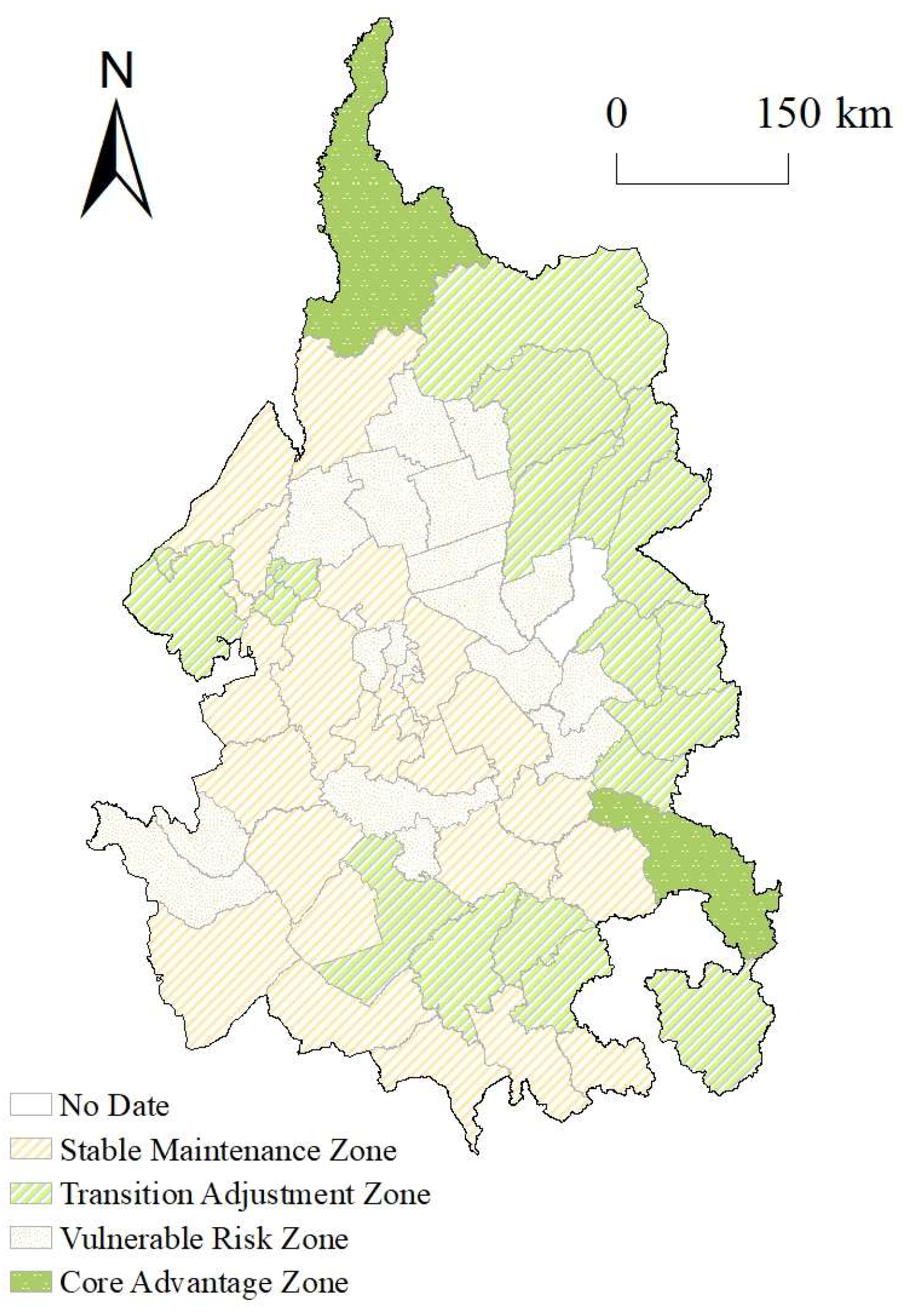
4.3. Analysis of Zoning Results for Cultivated Land System Resilience

Using the MATLAB R2022b software program, K-means clustering was applied to classify cultivated land system resilience across counties in the Songnen Plain. The study area was divided into four zones based on three resilience dimensions (resistance, adaptability, and reconstruction): the core advantage zone, the stable maintenance zone, the transition adjustment zone, and the vulnerable risk zone (Figure 10). The distinct characteristics of these zones highlight significant differences in agricultural production, ecosystem stability, and the ability to respond to external disturbances, providing a scientific basis for the precise management and sustainable development of cultivated land systems in the Songnen Plain (Table 4).
(1)
Core Advantage Zone. This zone exhibits the highest resilience level, primarily ecompassing Wuchang City and Nenjiang City, accounting for a relatively small proportion of the total area. It has advantageous natural resources, well-developed agricultural infrastructure, and advanced modern agricultural technologies, resulting in outstanding agricultural productivity and ecosystem stability. Wuchang City is renowned for its high-quality rice production, supported by abundant water resources, fertile black soil, and advanced agricultural mechanization and technological innovation. Nenjiang City similarly features high agricultural mechanization, high productivity, strong ecosystem recovery capacity, and diversified economic structures that ensure regional economic stability. Due to their strong resource management and adaptability to external changes, these areas serve as core demonstration regions for agricultural and resource management in the Songnen Plain. Policies should therefore consolidate their leading roles in modern agriculture, resource management, and ecological protection.
(2)
Stable Maintenance Zone. This zone is located in the central and northern regions of the Songnen Plain, comprising 23 counties and accounting for 36.51% of the study area. Agricultural production here remains relatively stable, characterized by limited changes in cultivated land area, moderate levels of agricultural mechanization, and medium values of cropping intensity and net primary productivity. Ecosystems in this zone recover gradually after disturbances but less efficiently than those in the core advantage zone. The stable maintenance zone demonstrates moderate adaptability and resistance but has limited resilience against extreme climate events or economic fluctuations. The primary sector dominates local economies, and while rural populations are sufficient, low skill levels and insufficient agricultural innovation limit agricultural productivity improvements. Counties such as Hulan District and Yi’an County exemplify this zone, having solid agricultural foundations but significant potential for enhancing mechanization and agricultural modernization. Policy recommendations include improving agricultural technology, optimizing resource management, and promoting economic diversification to strengthen regional adaptability and stability.
(3)
Transition Adjustment Zone. Primarily distributed in the northeastern fringe and southern areas of the Songnen Plain, this zone includes 20 counties, covering 30.16% of the study area. Agricultural practices remain traditional, with low mechanization, low cropping intensity, and limited ecosystem recovery capacity. Production efficiency is significantly constrained by natural conditions. This region suffers from moderate vegetation cover, fragmented landscapes, weak soil and water conservation, and high vulnerability to climate change and extreme weather events. The rural economy depends heavily on agriculture with a single-industry structure, lacking technological support and innovation. Typical counties include Wudalianchi City and Jiaohe City, characterized by low agricultural productivity, fragile ecosystems, and outdated water and soil management practices. Enhancing productivity and ecological stability in this zone thus requires strengthening water and soil resource management, developing irrigation infrastructure, and introducing modern agricultural technologies to enhance ecosystem restoration capacity.
(4)
Vulnerable Risk Zone. This zone is located in the central–western areas of the Songnen Plain, comprising 18 counties and accounting for 28.57% of the study area. It exhibits low agricultural productivity and weak ecosystem resilience, with significantly lower cropping intensity and production efficiency. Agricultural production is highly dependent on natural conditions, yet the region demonstrates limited resilience against extreme weather events. Declining soil fertility, severe soil erosion, and weak ecosystem recovery capacity exacerbate vulnerability. The rural economy is simplistic, with limited economic activities beyond agriculture, and suffers from severe labor migration and aging populations, further constraining agricultural productivity. Counties like Mingshui County and areas surrounding Harbin illustrate traditional agricultural practices with low mechanization and limited technology adoption, facing ecosystem degradation pressures. Priority policy support is necessary, particularly through ecological restoration, infrastructure development, and agricultural technology dissemination, enhancing the adaptability and stability of agricultural systems.
Overall, the cluster analysis highlights significant regional differentiation in agricultural productivity, ecological resilience, and resource management within the Songnen Plain. The core advantage zone should reinforce its demonstration role in advancing modern agricultural technology and optimized resource management. The stable maintenance zone should focus on technological improvement and economic restructuring, while the transition adjustment and vulnerable risk zones require targeted policy support, technology promotion, and ecological conservation measures to enhance their agricultural and ecological resilience.

5. Discussion

5.1. Spatiotemporal Differentiation and Zoning of Cultivated Land System Resilience

The results indicate that cultivated land system resilience in the Songnen Plain showed an upward trend from 2001 to 2021, accompanied by significant spatial heterogeneity among different regions. Human intervention positively influenced resilience enhancement. Although previous studies specifically on cultivated land system resilience in the Songnen Plain are limited, similar research supports these findings. Song et al. [11] analyzed the spatiotemporal changes and driving mechanisms of ecological vulnerability in the Songnen Plain from 1980 to 2020, demonstrating an overall decreasing vulnerability, indirectly indicating an upward trend in resilience over the past 40 years. Wu et al. [12] observed significant spatial differentiation and agglomeration of agricultural regional functions, characterized by higher resilience in eastern regions and lower resilience in western regions, aligning with the results of this study. Qin et al. [63] reported notable improvements in the Songnen Plain cultivated land system over the past two decades, reflected in improved soil quality, ecosystem service restoration, and increased agricultural productivity, thus indirectly supporting the observed resilience enhancement.
While the cultivated land system resilience in the Songnen Plain has shown an overall upward trend, this improvement is also reflected in the simultaneous enhancement of its three functional dimensions. The increase in resistance can be attributed primarily to rising net primary productivity (NPP), precipitation, and accumulated temperature. Li et al.’s [64] study indicated that from 2001 to 2020, the NPP of cultivated land in the study area demonstrated a consistent growth trend, accompanied by increased precipitation levels. Similarly, research by Lv et al. [65] revealed a rise in active accumulated temperature between 1993 and 2017, with projections suggesting continued growth across most of the region from 2017 to 2027. These climatic improvements lend credibility to the observed enhancement in the resistance dimension of cultivated land resilience. The enhancement of adaptability is closely linked to the increase in per capita cultivated land area and the growth of primary industry output. Statistical data show a negative population growth trend in the region, which has resulted in greater per capita land availability. As a major grain-producing area dominated by crop farming, the Songnen Plain has experienced increases in planting income, which contributed significantly to the growth of the primary industry output. These increases can be attributed to adjustments in cropping structure, increased agricultural inputs, and policy interventions. According to Du et al. [66], driven by economic incentives, the region witnessed an expansion of maize and rice cultivation and a decline in soybean production between 2000 and 2020. This shift in cropping pattern led to higher yields and, consequently, increased farmer income. Additionally, research by Zhang et al. [67] further corroborates that increased inputs, government subsidies, and farmland protection policies have enhanced land use efficiency and planting income in the region. Regarding reconstruction, total agricultural machinery power, vegetation cover, and landscape evenness have played pivotal roles in strengthening system resilience. The rise in total machinery power indicates a transition in agricultural operations from small-scale, labor-intensive practices to large-scale, mechanized production. Meanwhile, ecological spatial indicators such as vegetation cover, landscape evenness, and patch density have all shown positive trends, indicating an enhanced capacity of the cultivated land system to respond to environmental and socio-economic changes. The synergistic enhancement of resistance, adaptability, and reconstruction dimensions has collectively facilitated a regional-scale transformation of cultivated land system resilience in the Songnen Plain over the past two decades. Changes in climatic conditions and cropping regimes have improved land productivity, while the continued implementation of policies such as the “High-Standard Farmland Construction” and the “Black Soil Protection Project” have significantly improved land fertility and infrastructure conditions. Simultaneously, ecological policies like “Returning Farmland to Wetland” and the delineation of “Ecological Protection Red Lines for Wetlands” have contributed to the restoration of ecological functions. These multi-dimensional driving forces—including national farmland protection policies, agricultural modernization investments, and ecological restoration initiatives—have jointly propelled the system from a low-resilience, vulnerable state toward one with a medium-to-high resilience, robust status.
In addition, changes in major crop types provide insights into how adjustments in cropping structure may influence the evolution of cultivated land system resilience. According to the findings of Chen et al. [68] and Ma et al. [66], the maize-based cropping system in the Songnen Plain has undergone significant expansion, while the rice system has remained relatively stable, with a slight increase. In contrast, soybean cultivation has gradually become marginalized [69]. The expansion of maize cultivation has contributed to the growth of primary industry output and increased agricultural mechanization, which in turn positively affects resilience in terms of adaptability and reconstruction. However, the intensification of maize production is often accompanied by higher fertilizer input, which may impose ecological pressure on the system. In comparison, the relatively stable rice areas benefit from sufficient precipitation and strong ecological foundations, with favorable performance in indicators such as vegetation cover and landscape evenness, which support the ecological regulation capacity of the system. On the other hand, crops such as soybeans—characterized by lower economic returns and higher ecological dependency—have declined in proportion, reflecting a trade-off between economic efficiency and ecological function under current agricultural development pathways. Overall, changes in the spatial distribution of cropping zones indirectly contribute to the dynamic evolution of cultivated land system resilience by affecting agricultural output, input structures, and ecological restoration capacity.
The analysis of resilience indicators identified northern and central regions, exemplified by Wuchang City and Nenjiang City, as areas with higher resilience. Similar regional studies support these findings, with Zhang et al. [70] and Lei et al. [71] noting that Wuchang City’s sustained high resilience is primarily attributable to innovative agricultural management systems, enabling efficient utilization of production factors and improved resistance to external disturbances. Dai et al. [72] and Wang et al. [73] found that Nenjiang City’s strong resilience stems from its abundant natural resources, high agricultural mechanization, and effective policy support, enhancing agricultural productivity and ecological restoration capacity. These core advantage zones, such as Wuchang and Nenjiang, provide models for agricultural innovation and resource management that can further promote resilience and sustainability.
In contrast, transitional adjustment zones and vulnerable risk zones, mainly located in peripheral and central–western areas of the Songnen Plain, exhibit lower adaptability and recovery capacities due to constraints from natural conditions (e.g., insufficient rainfall and soil degradation) and socio-economic factors (e.g., inadequate infrastructure and limited technology dissemination).

5.2. Innovations

This study explores the spatiotemporal differentiation and zoning patterns of cultivated land resilience in the Songnen Plain, providing significant insights for sustainable land use, food security assurance, and social development needs. Similarly to previous resilience studies, this research interprets resilience as an interaction among the “resistance–adaptability–reconstruction” dimensions, positing that systems undergo adaptive cycles when faced with disturbances, leading to internal reorganization and upgrading. While international research predominantly focuses on theoretical frameworks, there are few studies explicitly adopting a “resistance–adaptability–reconstruction” perspective. Instead, many emphasize socio-economic, socio-ecological, or structural scales for evaluation. For instance, Huang et al. [74] developed evaluation indicators from natural suitability and socio-economic benefits for land consolidation, while Lv et al. [75] assessed resilience through dimensions such as production, ecology, form, and quality resilience or from perspectives of green agricultural transformation. This study introduces a novel resilience evaluation framework based on “resistance–adaptability–reconstruction”, providing a comprehensive perspective to assess cultivated land system responses to complex environmental and socio-economic challenges, thus informing targeted regional agricultural policies and land management strategies.
This research highlights the complexity and multi-dimensional nature of cultivated land systems by integrating climate conditions, socio-economic contexts, agricultural management capacity, and ecological restoration abilities. Temporal and spatial analyses, exemplified by Wuchang City, reveal regional differentiation and provide targeted recommendations for enhancing resilience in specific zones.
In summary, this study employs resilience theory to develop an innovative cultivated land resilience evaluation framework at the county scale. By adopting the “resistance–adaptability–reconstruction” framework, it enriches the existing literature on cultivated land resilience, facilitating effective regional spatiotemporal analysis and zoning. The research outcomes are crucial for ensuring sustainable land use, food security, adaptive transformation of farmland systems, and sustainable development.

5.3. Policy Recommendations

From the perspective of farmland protection policies and implementation, the pressures on cultivated land systems have been partially alleviated. However, given the region’s unique geographic, climatic, and spatial characteristics, further efforts are required to improve resilience. Based on these factors, this study proposes the following recommendations:
(1)
Enhance agricultural technology, and establish a robust disaster early warning system. Given the temperate continental monsoon climate of the Songnen Plain, characterized by warm, humid summers and cold, dry winters, it is essential to select and breed crop varieties that are drought-tolerant, cold-resistant, and pest-resistant, all suited to local climatic conditions and geared toward improving crop resilience. Additionally, adopting precision agriculture technologies—such as drone-based remote sensing, smart irrigation systems, and precise fertilization methods—can further strengthen agricultural resilience. This study found that natural factors, including precipitation and sunlight duration, influence farmland system resilience, so improving disaster early warning systems and enhancing meteorological monitoring to issue timely warnings will therefore help farmers prepare better and mitigate potential income losses from natural disasters. Furthermore, providing subsidized agricultural insurance can encourage greater participation from farmers. In core advantage regions of the southern and central areas (e.g., Wuchang City and Shuangcheng District), government-funded smart agriculture initiatives can introduce technologies like drone monitoring, soil sensors, and precision irrigation for more targeted management. For example, installing soil moisture sensors can enable real-time monitoring for precise irrigation and fertilization. As these technologies evolve, their expansion into areas with moderate adaptability can serve as a model to enhance production efficiency and resource conservation.
(2)
Strengthen land management and protection; complement ecological conservation and restoration. Preventing the conversion of farmland into non-agricultural or non-grain uses is crucial. Strict enforcement of farmland protection policies can curb illegal occupation and excessive development, thereby stabilizing farmland areas. Equally important is preserving the natural environment of the Songnen Plain to maintain ecological balance and prevent over-exploitation or ecological degradation. As a major production base for crops such as corn, soybeans, and rice, the black soil region of the Songnen Plain has increasingly been prioritized by China’s farmland protection initiatives in recent years. With programs such as high-standard farmland construction, land consolidation, and ecological restoration, the resilience of farmland systems has improved. As China transitions to high-quality development, refining farmland management mechanisms becomes even more critical. Ensuring no net reduction in farmland area, guaranteeing quality and quantity, optimizing land use structures, and enhancing land use efficiency are all necessary measures. These actions will not only promote economic development and sustainable agriculture but also protect ecosystems and reinforce the Songnen Plain’s role as a critical grain production base for China.
(3)
Adopt region-specific strategies based on zoning outcomes. Based on the zoning results, distinct strategies should be implemented for each zone according to its specific characteristics. In core advantage zones, focus should be placed on high-efficiency agriculture, the promotion of precision farming technologies, and green agricultural development, while establishing demonstration bases for the coordinated advancement of agriculture and ecology. In stable maintenance zones, optimizing crop structures, diversifying operational models, enhancing soil and water conservation, and improving soil quality through policy support and technology adoption can increase regional adaptability. In low-resilience zones, priorities should include soil improvement and ecological restoration projects, optimizing irrigation and drainage systems, developing climate-resilient specialty crops, and minimizing overdevelopment. In ecologically sensitive zones, strict ecological protection lines should be established, promoting ecological farming practices and intensifying efforts to restore wetlands and forests, ensuring the recovery and stability of regional ecosystems. Ultimately, these zoned management practices will support the sustainable use of farmland resources while promoting coordinated regional economic development.

5.4. Limitations and Outlook

5.4.1. Study Limitations

Despite the relatively comprehensive analytical framework constructed in this study, several limitations still warrant acknowledgment: First, this study adopts county-level administrative units as the basic scale of analysis, which facilitates overall comparative analysis at the regional scale. However, due to the relatively large spatial scale, it may obscure fine-grained spatial heterogeneity within cultivated land systems at the plot, village, or township levels. This limitation may lead to insufficient capture of important characteristics such as localized variations in farmland resilience, thereby affecting the precision of spatial differentiation results. Second, although this study integrates multiple datasets, due to the vast spatial extent of the study area and the relatively small size of research units, certain key socio-economic and ecological indicators (e.g., rural infrastructure levels and soil quality indicators) were unavailable during the data collection process, thereby limiting the depth and comprehensiveness of the analysis. Third, the selected study period (2001–2021) facilitates the understanding of historical trends in farmland resilience. However, with the intensification of global climate change, the acceleration of agricultural restructuring, and dramatic changes in rural socio-economic environments, it is difficult to comprehensively predict the evolution of farmland system resilience under different future scenarios based solely on past data, thus restricting reliable future trajectory predictions. Fourth, the four-zone classification method adopted in this study effectively reflects the spatial differences in farmland resilience across the Songnen Plain. However, compared to the internationally adopted hierarchical protection models, such as the UNESCO Biosphere Reserve zoning framework (core areas, buffer zones, and transition zones) [76], it remains relatively coarse. This discrepancy may limit the applicability and scalability of the study results in multi-scale land management practices.

5.4.2. Outlook and Future Work

Moving forward, advancing the research on farmland system resilience requires interdisciplinary collaboration across fields such as ecology, socio-economics, and agricultural sciences. The introduction of higher-resolution spatial data will contribute to more precise identification of local differences in farmland resilience, thereby improving the granularity and accuracy of spatial analysis. Future research should also focus on the spatiotemporal evolution of specific cropping systems and their dynamic coupling with resilience mechanisms. In addition, the establishment of long-term monitoring networks is crucial for systematically tracking changes in farmland resilience and evaluating the actual effectiveness of technological innovations and policy interventions. Finally, continuous evaluation and refinement of farmland policy mechanisms will be critical to further improving the resilience, sustainability, and productivity of farmland systems. Through the construction of a comprehensive and integrated research framework, the Songnen Plain is expected to achieve sustainable agricultural development while contributing to national food security and ecological integrity.

6. Conclusions

Drawing upon resilience theory, this study evaluates the cultivated land system resilience in the Songnen Plain by developing an indicator system for resilience assessment. Utilizing multi-source data—including remote sensing, meteorological records, land use information, and socio-economic statistics—and employing three-dimensional Euclidean distance, GIS spatial analysis, and other methods, we quantitatively characterize the spatiotemporal evolution of the cultivated land system in the Songnen Plain over three time points (2001, 2011, and 2021). We further reveal how both natural and anthropogenic factors contribute to spatial heterogeneity in cultivated land resilience. The key findings are as follows:
(1)
Overall Upward Trend in Resilience
Between 2001 and 2021, the cultivated land system resilience of the Songnen Plain showed a clear upward trend. This improvement is closely related to agricultural technological advancements and the optimization of land use structures, which collectively enhance the system’s resistance, adaptability, and reconstruction capacity. Spatially, resilience was higher in the eastern regions and relatively lower in the western and central regions. Areas such as Wuchang City and Nenjiang City consistently maintained higher resilience over the past two decades, whereas places like Ningjiang District and Jiaohe City saw comparatively modest improvements. Additionally, the finding that improvements in resistance contribute most to resilience enhancement—followed by adaptability and reconstruction—offers quantitative guidance for balancing agricultural productivity with ecological sustainability. By establishing a three-dimensional resilience framework that integrates resistance, adaptability, and reconstruction, we provide a unified basis for identifying vulnerability and assessing recovery capacity under complex external pressures.
(2)
Kernel Density Analysis
Kernel density estimation effectively mitigates noise in the data and reveals authentic distribution trends, identifying hotspots and distribution patterns of cultivated land system resilience. The results indicate that resilience values have grown increasingly concentrated over time, shifting steadily to the right on the value axis. Peak values initially increased and then decreased slightly, while the differences among regions have gradually intensified. Additionally, it is important to note that a Kernel Density Analysis (KDA), while effective in identifying the spatial distribution trends of resilience, does not independently explain the underlying mechanisms driving resilience changes. Therefore, this study complemented KDA with three-dimensional Euclidean distance measurements and K-means clustering analyses to provide a more comprehensive interpretation of cultivated land system resilience dynamics.
(3)
Zoning Results
According to the clustering-based zoning, transition adjustment areas and vulnerable risk areas face substantial ecological and economic challenges, characterized by lower adaptability and resource-use efficiency. These areas urgently require policy support, resource allocation, and technological intervention to bolster resilience. Stable maintenance areas display a certain capacity for adaptation and resistance to external pressures, albeit with a limited ability to respond to abrupt environmental changes. In comparison, core advantage areas exhibit strong agricultural productivity and resource management capabilities, effectively coping with external changes while sustaining ecosystem health and productivity. The zoning approach thus provides a powerful tool for evaluating farmland resilience and yields operational tools for differentiated land consolidation and ecological restoration. It enables more precise, region-specific strategies for farmland management in the Songnen Plain, thereby supporting the achievement of sustainable development goals.
In summary, to address the increasing vulnerability of cultivated land systems under climate change, land degradation, and socio-economic pressures, this study proposes targeted solutions through the construction of a comprehensive resilience evaluation framework. By quantifying resilience characteristics across resistance, adaptability, and reconstruction dimensions, revealing spatial heterogeneity using three-dimensional Euclidean distance, and implementing regional zoning through K-means clustering, this study provides practical tools for enhancing farmland stability, promoting adaptive agricultural practices, and guiding ecological restoration efforts. These findings offer a scientific basis for formulating integrated, multi-dimensional land management strategies, thereby facilitating the sustainable development of agricultural production and ecosystem services under dynamic environmental conditions.

Author Contributions

Conceptualization, supervision, and project administration, Y.H.; study design, methodology, data curation, validation, and original draft preparation, X.L. (Xue Lu); formal analysis, methodology, X.L. (Xiaoming Li). All authors have read and agreed to the published version of the manuscript.

Funding

This research was funded by the “National Key Research and Development Program of China”, grant number “2021YFD1500104-2”.

Institutional Review Board Statement

Not applicable.

Informed Consent Statement

Not applicable.

Data Availability Statement

The data published in this study are available from the corresponding author on request. The data are not publicly available due to the policy of the research project.

Acknowledgments

We sincerely appreciate the reviewers for their valuable comments and constructive suggestions, which greatly helped to improve the quality of this manuscript.

Conflicts of Interest

The authors declare no conflicts of interest.

References

  1. Lal, R. Soil carbon sequestration to mitigate climate change. Geoderma 2004, 123, 1–22. [Google Scholar] [CrossRef]
  2. Turner, B.L., 2nd; Lambin, E.F.; Reenberg, A. The emergence of land change science for global environmental change and sustainability. Proc. Natl. Acad. Sci. USA 2007, 104, 20666–20671. [Google Scholar] [CrossRef]
  3. Zhao, Z.; Lei, M.; Wen, L.; Xie, E.; Kong, X. Research status, development trends, and the prospects of cultivated land risk. Front. Environ. Sci. 2023, 11, 1175239. [Google Scholar] [CrossRef]
  4. Reid, W.V.; Mooney, H.A.; Cropper, A.; Capistrano, D.; Carpenter, S.R.; Chopra, K.; Dasgupta, P.; Dietz, T.; Duraiappah, A.K.; Hassan, R. Ecosystems and Human Well-Being-Synthesis: A Report of the Millennium Ecosystem Assessment; Island Press: Washington, DC, USA, 2005. [Google Scholar]
  5. Metzger, M.J.; Rounsevell, M.D.A.; Acosta-Michlik, L.; Leemans, R.; Schröter, D. The vulnerability of ecosystem services to land use change. Agric. Ecosyst. Environ. 2006, 114, 69–85. [Google Scholar] [CrossRef]
  6. Folke, C. Resilience: The emergence of a perspective for social–ecological systems analyses. Glob. Environ. Chang. 2006, 16, 253–267. [Google Scholar] [CrossRef]
  7. Carpenter, S.; Walker, B.; Anderies, J.M.; Abel, N. From Metaphor to Measurement: Resilience of What to What? Ecosystems 2014, 4, 765–781. [Google Scholar] [CrossRef]
  8. Walker, B.; Salt, D. Resilience Thinking: Sustaining Ecosystems and People in a Changing World; Island Press: Washington, DC, USA, 2012. [Google Scholar]
  9. Gallopín, G.C. Linkages between vulnerability, resilience, and adaptive capacity. Glob. Environ. Change 2006, 16, 293–303. [Google Scholar] [CrossRef]
  10. Xu, W.; Jin, X.; Liu, J.; Li, H.; Zhang, X.; Zhou, Y. Spatiotemporal evolution and the detection of key drivers in the resilience of cultivated land system in major grain-producing regions of China. Land Degrad. Dev. 2023, 34, 4712–4727. [Google Scholar] [CrossRef]
  11. Song, C.; Xiang, H.; Chen, M.; Du, H. Spatiotemporal differentiation of ecological vulnerability in the Songnen Plain from 1980 to 2020. Bull. Soil Water Conserv. 2023, 43, 366–374. [Google Scholar] [CrossRef]
  12. Wu, Y. Spatiotemporal Evolution Characteristics and Influencing Factors of Agricultural Regional Functions in the Songnen Plain. Master’s Thesis, Northeast Normal University, Changchun, China, 2022. [Google Scholar]
  13. Cimellaro, G.P.; Reinhorn, A.M.; Bruneau, M. Framework for analytical quantification of disaster resilience. Eng. Struct. 2010, 32, 3639–3649. [Google Scholar] [CrossRef]
  14. Alexander, D.E. Resilience and disaster risk reduction: An etymological journey. Nat. Hazards Earth Syst. Sci. 2013, 13, 2707–2716. [Google Scholar] [CrossRef]
  15. Holling, C.S. Resilience and stability of ecological systems. In International Institute for Applied Systems Analysis Laxenburg; Cambridge University Press: Cambridge, UK, 1973. [Google Scholar]
  16. Adger, W.N. Social and ecological resilience: Are they related? Prog. Hum. Geogr. 2000, 24, 347–364. [Google Scholar] [CrossRef]
  17. Folke, C.; Carpenter, S.R.; Walker, B.; Scheffer, M.; Chapin, T.; Rockström, J. Resilience thinking: Integrating resilience, adaptability and transformability. Ecol. Soc. 2010, 15, 4. Available online: https://www.jstor.org/stable/26268226 (accessed on 6 May 2025).
  18. Xie, H. Study on the impact of cultivated land quality improvement strategies on the yield of major grain crops. Seed Sci. Technol. 2025, 43, 207–209. [Google Scholar] [CrossRef]
  19. Chen, M.; Lv, J. Evaluation of cultivated land ecological security and obstacle factor diagnosis in the upper reaches of the Yellow River based on the entropy weight–TOPSIS method. J. Yunnan Agric. Univ. 2024, 18, 72–80. [Google Scholar] [CrossRef]
  20. Lee, C.-C.; Qian, A. Regional differences, dynamic evolution, and obstacle factors of cultivated land ecological security in China. Socio-Econ. Plan. Sci. 2024, 94, 101970. [Google Scholar] [CrossRef]
  21. Gong, P.; Ren, Y. Spatiotemporal evolution of cultivated land ecosystem resilience in Inner Mongolia from a social–ecological perspective. J. Arid. Land Resour. Environ. 2025, 39, 84–93. Available online: https://kns.cnki.net/kcms2/article/abstract?v=RNPVX-4KY7iW5GLMWRD10hjw16DGywnIVvkMU5efsH1BUUAQQIV1bN9Bcnw9CVU7TPhyy9ts9-e_0nbSryqSUvwgpEItzgigozX190TsEqNA_Ytflfo_vso6CdnxWqEOjuiHfir8E2cLaTIJUW6ChpCsN_Frbllax_8G6dweEWmx7RwGmesmo08SABGQcC9ZbMa-dxP20tY=&uniplatform=NZKPT (accessed on 6 May 2025).
  22. Chen, L.; Zhao, N.; Zhang, Z.; Zhang, Y.; Zuo, W.; Wang, Y.; Wu, B.; Stanny, M.; Li, Y.; Du, G. Population Shrinkage and Spatio-Temporal Changes in Cultivated Land Use Efficiency in China’s Agro-Pastoral Ecotone. Land 2025, 14, 63. [Google Scholar] [CrossRef]
  23. Zhang, H.; Zhu, C.; Jiao, T.; Luo, K.; Ma, X.; Wang, M. Analysis of the Trends and Driving Factors of Cultivated Land Utilization Efficiency in Henan Province from 2000 to 2020. Land 2024, 13, 2109. [Google Scholar] [CrossRef]
  24. Ma, M.; Guo, H.; Li, J.; Song, Y. Spatiotemporal evolution and interactive response of cultivated land multifunctionality and use efficiency: A case study of Guangdong Province. J. Shandong Inst. Agric. Eng. 2024, 41, 25–36. [Google Scholar] [CrossRef]
  25. Yin, Z. Spatiotemporal variation of land use patterns and their relationship with climatic factors in the Songnen Plain. Environ. Impact Assess. 2023, 45, 63–71. [Google Scholar] [CrossRef]
  26. Zhang, X.; Cen, Y.; Gao, Z.; Li, Y.; Sun, G.; Liu, W. Response of ecological environmental quality to climate and land use change on the Loess Plateau from 2001 to 2020. Bull. Soil Water Conserv. 2023, 43, 234–244. [Google Scholar] [CrossRef]
  27. Cai, B.; Xie, M.; Liu, Y.; Liu, Y.; Feng, Q. Availability-based engineering resilience metric and its corresponding evaluation methodology. Reliab. Eng. Syst. Saf. 2018, 172, 216–224. [Google Scholar] [CrossRef]
  28. Lei, S.; Zhao, W.; Lei, Y. Research on the improvement of engineering resilience in urban underground space. Tunn. Constr. 2023, 43, 1627–1636. Available online: https://kns.cnki.net/kcms2/article/abstract?v=RNPVX-4KY7hCUZdaZq3GjmQm2xOPaOVlqKcuLUp5gksAkHsaEPG4ARv7yUej0s-InrQ1LvcPwmePPE4_HB35m0hCn19_mC0J7eIqDbshKZcMkF_W0UqyZBGoC2zaOJMmhFuRlyacgqSwmStluuE4bht1-D2xqcAIPc74nBPAOq3TyElIYRuGy9-joT-JSY3KatJLfT_olc8=&uniplatform=NZKPT (accessed on 6 May 2025).
  29. Zhao, H.; Qu, X.; Feng, X.; Wu, K.; Huang, Q. Theoretical and empirical study on the elastic deformation of cultivated land. Areal Res. Dev. 2012, 31, 73–77. [Google Scholar]
  30. Lyu, X.; Wang, Y.; Niu, S.; Peng, W. Spatio-Temporal Pattern and Influence Mechanism of Cultivated Land System Resilience: Case from China. Land 2021, 11, 11. [Google Scholar] [CrossRef]
  31. Fang, Y.; Wang, Q.; Huang, Z.; Wu, Y. Spatiotemporal evolution and influencing mechanisms of tourism economic resilience in China. Prog. Geogr. 2023, 42, 417–427. Available online: https://kns.cnki.net/kcms2/article/abstract?v=RNPVX-4KY7hvvRmkT3Z3YM7NfdqGuwi-SvBkTKkiMPTa_pZ49gQkaaDraP1kTKqLnx85vUW5BiylMdtY1MwJ_UUyLKj6BtCiEC5kLKWa2ql9-V1kqyQsOEbqh_yRQNjsK5HfmroENLCtUQ7mn_qlfnvtqxSfpbU2jbhCM67YfR2ey5HD-m5bzPIWZrT7kbfvlJkXqA9OjTY=&uniplatform=NZKPT (accessed on 6 May 2025). [CrossRef]
  32. Paas, W.; San Martín, C.; Soriano, B.; van Ittersum, M.K.; Meuwissen, M.P.M.; Reidsma, P. Assessing future sustainability and resilience of farming systems with a participatory method: A case study on extensive sheep farming in Huesca, Spain. Ecol. Indic. 2021, 132, 108236. [Google Scholar] [CrossRef]
  33. Li, L.; Zhang, Y.; Fu, B.; Song, X.; Zhang, Y. Evaluation and spatial differentiation of cultivated land resilience in Kunming City. Sci. Technol. Eng. 2021, 21, 4848–4855. [Google Scholar]
  34. Zhang, Y.; Zhou, D.; Li, Z.; Qi, L. Spatial and temporal dynamics of social-ecological resilience in Nepal from 2000 to 2015. Phys. Chem. Earth Parts A/B/C 2020, 120, 102894. [Google Scholar] [CrossRef]
  35. Jiao, L.; Deng, J.; Wu, Y.; Huo, X. Evaluation of urban resilience level based on the PSR–cloud model. Ecol. Econ. 2022, 38, 114–120. [Google Scholar]
  36. Yin, X.; Li, Z.; Xu, G.; Wan, C. Integrating Resilience Theory into a Cultivated Land System: Empirical Insights from China’s Key Grain-Producing Regions. Land Degrad. Dev. 2024, 35, 5425–5438. [Google Scholar] [CrossRef]
  37. Miao, X.; Li, Z.; Wang, M.; Mei, J.; Chen, J. Measurement of cultivated land ecosystem resilience in black soil region of Northeast China under the background of cultivated land protection policy in China: Case study of Qiqihar City. J. Clean. Prod. 2024, 434, 140141. [Google Scholar] [CrossRef]
  38. Zhu, Q.; Cai, Y. Impacts of ecological risk and ecosystem health on ecosystem services. Acta Geogr. Sin. 2024, 79, 1303–1317. [Google Scholar]
  39. Bush, J.; Doyon, A. Building urban resilience with nature-based solutions: How can urban planning contribute? Cities 2019, 95, 102483. [Google Scholar] [CrossRef]
  40. Cai, X.; Wu, Y.; Zou, X. Formation mechanism of resilience networks in alternative agricultural production from a social–ecological system perspective: A case study of Guangzhou. Sci. Geogr. Sin. 2024, 44, 1524–1533. [Google Scholar] [CrossRef]
  41. Zhou, K.; Liu, B.; Fan, J. Measurement of economic resilience and recovery efficiency in the worst-hit areas of the Wenchuan Ms 8.0 earthquake. Acta Geogr. Sin. 2019, 74, 2078–2091. [Google Scholar]
  42. Sun, Y.; Zhang, L.; Yao, S. Evaluation of urban resilience in prefecture-level cities of the Yangtze River Delta from a social–ecological system perspective. China Popul. Resour. Environ. 2017, 27, 151–158. [Google Scholar]
  43. Liu, Y.; Qiao, L. Cultivated land protection system and policy innovation under the new-type urbanization in China. Econ. Geogr. 2014, 34, 1–6. [Google Scholar] [CrossRef]
  44. Long, H.; Qu, Y. Land use transitions and land management: A mutual feedback perspective. Land Use Policy 2018, 74, 111–120. [Google Scholar] [CrossRef]
  45. Li, Y.; Huang, H.; Guo, T.; Du, G. Cultivated land resilience under multiple pressure stress in the black soil region of Northeast China: A case study of Baiquan County, Heilongjiang Province. China Land Sci. 2022, 36, 71–79. [Google Scholar] [CrossRef]
  46. Liang, X.; Jin, X.; Sun, R.; Han, B.; Ren, J.; Zhou, Y. Resilient spatial potential of cultivated land protection under bottom-line constraints of food security in multiple scenarios in China. Acta Geogr. Sin. 2022, 77, 697–713. Available online: https://kns.cnki.net/kcms2/article/abstract?v=RNPVX-4KY7iLl_f4xA_dbk--TIproYOyicLe9sWvb3abj31mDdqmRq2GtOFczHpsB8GODdqgB6iUyQcvDKSR2FdPj_ncg2ha9AOs-I0ioa2LTUuYwbJjqPWQk8IPctqIqLhIAYq60pxo9Vc4ZNvXuhn6uEGWinBRk0y2tWUpp8eJ8GSLk23hyoI4h5673LGlbMqsMdrXq-k=&uniplatform=NZKPT (accessed on 6 May 2025).
  47. Lü, T.; Chen, A.; Fu, S.; Zhao, Q.; Liang, H. Spatiotemporal evolution and influencing factors of cultivated land system resilience under the green transformation of agriculture in China. Acta Ecol. Sin. 2025, 45, 2891–2904. [Google Scholar] [CrossRef]
  48. Ji, Z.; Wang, P. Measurement and dynamic evolution of cultivated land system resilience in arid regions: A case study of Xinjiang. J. Agric. Resour. Environ. 2024, 1–14. Available online: https://kns.cnki.net/kcms2/article/abstract?v=RNPVX-4KY7jLRHsF8AvgoBvRPxB5BaSa3xFAOCsRm3vNRKkFUvwSrXFfKEPAjLfo4Dz6IyTHTuUmyOIX1V06J2e0jbN7stiqVHq0sK-hC-jjwVXqW3KmFmYka-Q4dxqjuTI7MpqEGtmby0pj10HMiOIbapnvCbafU04sDoX8BrE8ux59qJOmumR8dNuhF9N1o6AxeRs1l6c=&uniplatform=NZKPT (accessed on 6 May 2025).
  49. Liu, W.; Song, G.; Gao, J.; Sui, H.; Wang, Q. Spatiotemporal differentiation of cultivated land system resilience in typical areas of the Lower Liaohe Plain. Trans. Chin. Soc. Agric. Eng. 2023, 39, 252–260. Available online: https://kns.cnki.net/kcms2/article/abstract?v=RNPVX-4KY7g8MWR0A33IjLSA4TyqmosNJ_r-3vwfifQoQvm7IhPOJ_8SRdRVWl6vCUeVW_lHyk5FaVMIp8rnGgiGNCa0fQME6nU-KVAJ_ki8bgJS_8MpiwzH6mYJDShSAzhrS1bX-9YZbeR4VHlA-JzBXX-lkY6LtWD30UvHcF4sxUikcTvvuDqaFXfaIw--mNBGBSv3KAY=&uniplatform=NZKPT (accessed on 6 May 2025).
  50. Zhang, Y.; Fang, S. Urban lifeline construction and enterprise strategic planning under resilience thinking: An observation based on urban drainage systems. China Emerg. Manag. Sci. 2025, 3, 111–123. [Google Scholar]
  51. Cao, S.; Li, Y.; Zhang, G.; Jiao, C.; Li, A. High-Performance Scientific Facilities Empower Engineering Resilience: Development and Practice of the Large-Scale Multi-Functional Earthquake Simulation System. Exp. Technol. Manag. 2025, 1–10, early access. Available online: http://kns.cnki.net/kcms/detail/11.2034.T.20250314.1706.006.html (accessed on 6 May 2025).
  52. Meerow, S.; Newell, J.P.; Stults, M. Defining urban resilience: A review. Landsc. Urban Plan. 2016, 147, 38–49. [Google Scholar] [CrossRef]
  53. Leichenko, R. Climate change and urban resilience. Curr. Opin. Environ. Sustain. 2011, 3, 164–168. [Google Scholar] [CrossRef]
  54. Sasaki, T.; Furukawa, T.; Iwasaki, Y.; Seto, M.; Mori, A.S. Perspectives for ecosystem management based on ecosystem resilience and ecological thresholds against multiple and stochastic disturbances. Ecol. Indic. 2015, 57, 395–408. [Google Scholar] [CrossRef]
  55. Yi, C.; Jackson, N. A review of measuring ecosystem resilience to disturbance. Environ. Res. Lett. 2021, 16, 21–32. [Google Scholar] [CrossRef]
  56. Zhou, Y.; Li, X.; Liu, Y. Cultivated land protection and rational use in China. Land Use Policy 2021, 106, 105454. [Google Scholar] [CrossRef]
  57. Zimmerman, J.K.; Willig, M.R.; Hernández-Delgado, E.A. Resistance, resilience, and vulnerability of social-ecological systems to hurricanes in Puerto Rico. Ecosphere 2020, 11, 105454. [Google Scholar] [CrossRef]
  58. Hu, J.; Bumeiremu, K.; Muhetar, A. Application of the entropy weight method in the balance between ecological protection and economic development in agricultural production. Res. Land Nat. Resour. 2025, 3, 55–58. [Google Scholar] [CrossRef]
  59. Li, D.; Jiang, N.; Tian, X.; Shi, Q.; Ni, P.; Dong, H. Agricultural water rights allocation in irrigation districts based on an improved entropy weight method. Water Conserv. Sci. Technol. Econ. 2023, 29, 17–21. [Google Scholar] [CrossRef]
  60. Shih, F.Y.; Wu, Y.-T. Three-dimensional Euclidean distance transformation and its application to shortest path planning. Pattern Recognit. 2004, 37, 79–92. [Google Scholar] [CrossRef]
  61. Węglarczyk, S. Kernel density estimation and its application. In Proceedings of the XLVIII Seminar of Applied Mathematics 2018, Wroclaw, Poland, 9–11 September 2018; p. 37. [Google Scholar]
  62. Na, S.; Xumin, L.; Yong, G. Research on k-means clustering algorithm: An improved k-means clustering algorithm. In Proceedings of the 2010 Third International Symposium on Intelligent Information Technology and Security Informatics, Ji’an, China, 2–4 April 2010; pp. 63–67. [Google Scholar]
  63. Qin, S.; Sun, J.; Chang, K.; Xu, Y.; Wang, J. Spatiotemporal variation of soil organic matter content and its influencing factors in the black soil region of the Songnen Plain. J. Agric. Resour. Environ. 2025, 42, 120–129. [Google Scholar] [CrossRef]
  64. Lin, N.; Li, J.; Jiang, R.; Li, X.; Liu, S. Quantifying the Spatiotemporal Variation of NPP of Different Land Cover Types and the Contribution of Its Associated Factors in the Songnen Plain. Forests 2023, 14, 1841. [Google Scholar] [CrossRef]
  65. Lin, N.; Jiang, R.; Liu, Q.; Yang, H.; Liu, H.; Yang, Q. Quantifying the Spatiotemporal Variation of Evapotranspiration of Different Land Cover Types and the Contribution of Its Associated Factors in the Xiliao River Plain. Remote Sens. 2022, 14, 252. [Google Scholar] [CrossRef]
  66. Guoming, D.U.; Mengqi, M.A.; Rui, Z.; Zhengjia, L.I.U. Change of maize-soybean cropping patterns and its link with climate warming in Northeast China between 2000 and 2020. Resour. Sci. 2024, 46, 2251–2262. [Google Scholar] [CrossRef]
  67. Zhang, H.; He, Z.H.; Zhang, L.W.; Wei, W.T.; Wang, S.Y.; Ma, Q.X. Spatiotemporal evolution and influencing factors of low-carbon utilization efficiency of cultivated land in the Songnen Plain, Heilongjiang Province from 2005 to 2020. Bull. Soil Water Conserv. 2024, 44, 335–346. Available online: https://kns.cnki.net/kcms2/article/abstract?v=RNPVX-4KY7jcltgLrX6PYLmTVZHhGA3CeHljFwSO3LPy4A1cLVMLJjSOSBDJ_4Y9gCXThrLAJ4mMADDt4bbBlxdx4mnsmoKFsQJbuAup7qVdRnZykbej2SEENtJegYdq5xjy33PDtXz4mWJ18995Rc8LE2bFRGKg3bEvMHAmnfWjalhuNjua4GVxf3lRJISZ8RT5yyyKNFU=&uniplatform=NZKPT (accessed on 6 May 2025).
  68. Chen, L.; Chen, X.; Pan, W.; Wang, Y.; An, Y.; Gu, Y.; Liu, H.; Yang, F. Assessing Rural Production Space Quality and Influencing Factors in Typical Grain-Producing Areas of Northeastern China. Sustainability 2023, 15, 14286. [Google Scholar] [CrossRef]
  69. Du, G.; Yao, X.; Zang, L. Evolution of Tillage Systems and Its Influencing Factors in the Black Soil Region of Northeast China. Chin. J. Eco-Agric. (Biling. Ed.) 2025, 33, 646–655. Available online: https://kns.cnki.net/kcms2/article/abstract?v=RNPVX-4KY7hN5GaguyKqm91H_uFkDgzmab-lCEvYBwNOnBOkkdI2vcIkz-IMInhGTOd22Qda43XkFwE47tNf_op8GZLsCNGZIviZv1NP5_hu6_HORvSZZ3VmUDcUbuaGsypnnrljqWA6mHH5x8Zt9cidVjgkFAF2n8eCo6HezQCFLpzr3bI1NK01np1I8zLM&uniplatform=NZKPT (accessed on 6 May 2025).
  70. Zhang, C.P.; Liu, F.; Yun, W.J. Investigation on the ecological protection and restoration of cultivated land in Heilongjiang. China Land 2021, 12, 26–28. [Google Scholar] [CrossRef]
  71. Lei, P.; Zhan, H. Food security and innovation in agricultural management systems: A case study of Wuchang City. Seek. Truth 2017, 2, 74–83. [Google Scholar]
  72. Dai, J.; Peng, W.; Lian, L.; Li, Z. Cultivated land use efficiency in the black soil region of Northeast China based on DEA: A case study of Nenjiang County. J. Arid. Land Resour. Environ. 2017, 31, 38–43. [Google Scholar] [CrossRef]
  73. Wang, L. Investigation on the protection and utilization of black soil in Nenjiang County. Contemp. Rural. Financ. Econ. 2018, 1, 58–59. [Google Scholar]
  74. Huang, X. Theoretical Basis and Index System of Cultivated Land Consolidation Potential Evaluation. Eurasia J. Sci. Technol. 2024, 6, 30–36. [Google Scholar] [CrossRef]
  75. Lv, J.; Jiang, W.; Ma, L.; Xu, H.; Li, Q. Resilience evaluation of cultivated land systems in the Taihang Mountains and piedmont plain: A case study of Shijiazhuang City. Geogr. Geo-Inf. Sci. 2024, 40, 110–117. [Google Scholar] [CrossRef]
  76. Ishwaran, N.; Persic, A.; Tri, N.H. Concept and Practice: The Case of UNESCO Biosphere Reserves. Int. J. Environ. Sustain. Dev. 2008, 7, 118–131. [Google Scholar] [CrossRef]
Figure 1. Evolutionary process of cultivated land system resilience.
Sustainability 17 04314 g001
Figure 2. Process of Cultivated Land System Functioning.
Sustainability 17 04314 g002
Figure 3. Overview of the study area and current land use map.
Sustainability 17 04314 g003
Figure 4. Measurement results of cultivated land system resilience in the study area from 2001 to 2021.
Sustainability 17 04314 g004
Figure 5. Kernel density distribution of cultivated land system resilience in the study area.
Sustainability 17 04314 g005
Figure 6. Spatial distribution of cultivated land system resilience in the study area.
Sustainability 17 04314 g006
Figure 7. Spatiotemporal distribution of resistance in cultivated land use systems.
Sustainability 17 04314 g007
Figure 8. Spatiotemporal distribution of adaptability in cultivated land use systems.
Sustainability 17 04314 g008
Figure 9. Spatiotemporal distribution of reconstruction in cultivated land use systems.
Sustainability 17 04314 g009
Figure 10. Zoning map of the study area.
Sustainability 17 04314 g010
Table 1. Data sources.
DataTypeSource
Land Use DataRaster DataData Center for Resources and Environmental Sciences, Chinese Academy of Sciences
NPPRaster DataMOD17A3HGF.006 Data
DEMRaster DataASTER GDEM Digital Elevation Model
Meteorological DataRaster DataNational Earth System Science Data Center
Administrative BoundariesVector DataData Center for Resources and Environmental Sciences, Chinese Academy of Sciences
Socio-economic DataStatistical DataStatistical Yearbooks of Various Provinces and Cities
Table 2. Evaluation index system for cultivated land system resilience in the study area.
Criteria LayerIndicatorIndicator DefinitionAttributeWeight
Primary LevelSecondary Level
ResistanceCultivated Land Production SustainabilityCultivated Land Area Change Rate(Calculated as cultivated land area in the previous year/current cultivated land area/spatial unit) × 100; higher values indicate greater land fluctuation, negatively affecting system stability and resilience0.0166
Multiple Cropping IndexMeasurement of land use efficiency; reflects the degree to which cultivated land in the study area is effectively used within a year, calculated as follows: Total Sown Area/Total Cultivated Land Area × 100%+0.1597
Net Primary ProductivityIndicates productivity fluctuation; higher NPP reflects stronger ecosystem function and agricultural potential+0.2774
Climate ConditionsAnnual PrecipitationConsiders the impact of natural baseline factors on the resistance of cultivated land+0.3522
Sunshine HoursIndicates solar radiation intensity; more sunlight supports photosynthesis and longer growing periods, enhancing productivity and climate adaptability+0.1941
AdaptabilitySocio-Economic ConditionsPrimary Industry Output ValueMeasurement of social state changes; reflects the economic benefits of cultivated land+0.5125
Proportion of Rural PopulationHigher proportion of rural population; cultivated land with a higher rural population proportion has a stronger response to various changes+0.1700
Patch Cohesion IndexHigher cohesion index; indicates a stronger ability to adapt to disturbances+0.0272
Per Capita Cultivated Land AreaMore cultivated land per capita indicates lower land pressure and better resource availability, supporting sustainable management+0.2903
ReconstructionAgricultural Management CapacityTotal Agricultural Machinery PowerThe level of agricultural machinery reflects the agricultural technological level within the region+0.3207
Amount of Fertilizer AppliedThe capacity to respond to cultivated land that has been subjected to human disturbances exceeding a threshold0.0382
Ecological Restoration CapacityFractional Vegetation CoverReflects the ecological condition of cultivated land; higher coverage indicates better ecological restoration, soil, and water conservation and stronger risk resistance+0.0545
Landscape EvennessHigher landscape evenness indicates a more uniform distribution of landscape types, which enhances the cultivated land system’s ability to reconstruct itself+0.1668
Patch DensityGreater patch density suggests a stronger ability to learn and reconstruct in response to external disturbances+0.4197
Note: “+” indicates a positive indicator attribute, while “−” indicates a negative indicator attribute.
Table 3. Examples showing limitations of the traditional entropy weight method.
Entropy ValueEntropy Weight
e1e2e3W1W2W3
0.99990.99980.99970.16670.33330.5
Table 4. Characteristics of each zone in the study area.
TypeQuantityCharacteristics
Core Advantage Zones2High agricultural productivity, ecological stability, diversified economy, and strong risk resilience.
Stable Maintenance Zones23Moderate production and ecological recovery capacity, and agriculture dependence, with limited pressure resistance.
Transition Adjustment Zones20Traditional production methods, strong resource dependence, and weaker adaptability.
Vulnerable Risk Zones18Low productivity, ecological fragility, economic monoculture, and high susceptibility to external shocks.
Disclaimer/Publisher’s Note: The statements, opinions and data contained in all publications are solely those of the individual author(s) and contributor(s) and not of MDPI and/or the editor(s). MDPI and/or the editor(s) disclaim responsibility for any injury to people or property resulting from any ideas, methods, instructions or products referred to in the content.

