Article

Advancing Urban Healthcare Equity Analysis: Integrating Public Participation GIS with Fuzzy Best–Worst Decision-Making


1
Department of Geospatial Information Systems, Faculty of Geodesy and Geomatics Engineering, K. N. Toosi University of Technology, Tehran 19967-15433, Iran
2
Department of Remote Sensing and Geospatial Information System, Faculty of Geography, University of Tehran, Tehran 14174-66191, Iran
3
Department of Biomedical Engineering, University of Calgary, Calgary, AB T2N 1N4, Canada
4
Department of Geomatics Engineering, University of Calgary, Calgary, AB T2N 1N4, Canada
5
Department of Pathology, Microbiology, and Immunology, School of Veterinary Medicine, University of California, Davis, CA 95616, USA
6
Department of Civil, Environmental Engineering and Architecture (DICAAR), University of Cagliari, 09123 Cagliari, Italy
*
Author to whom correspondence should be addressed.
Sustainability 2024, 16(5), 1745; https://doi.org/10.3390/su16051745
Submission received: 20 December 2023 / Revised: 2 February 2024 / Accepted: 15 February 2024 / Published: 20 February 2024

Abstract

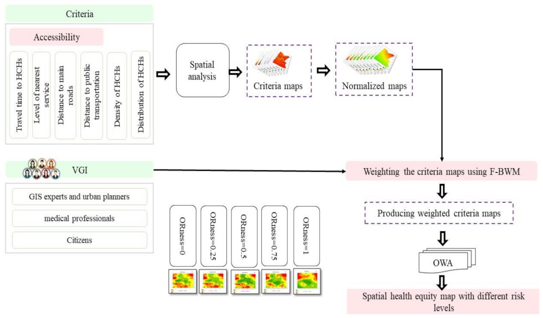
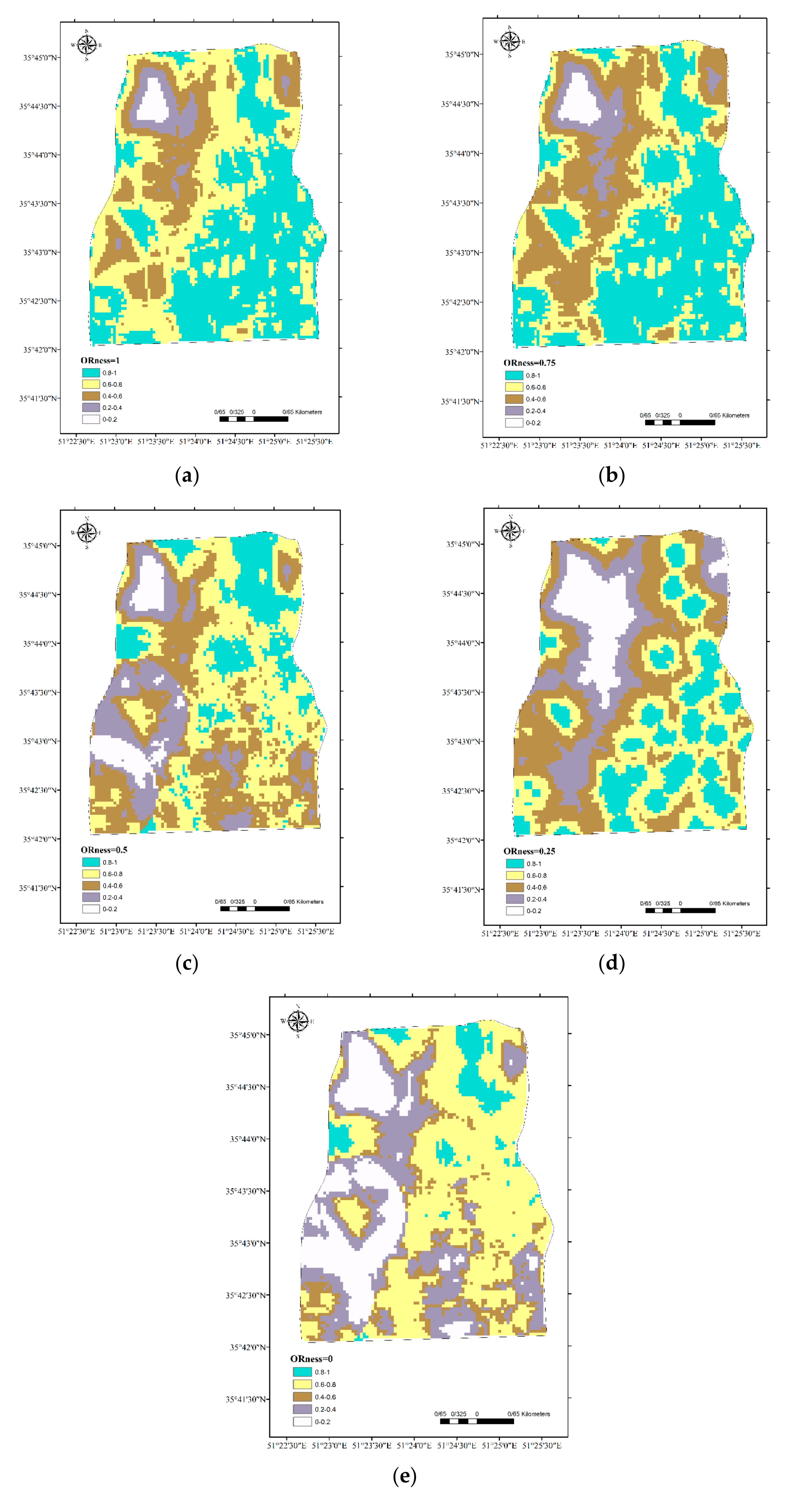
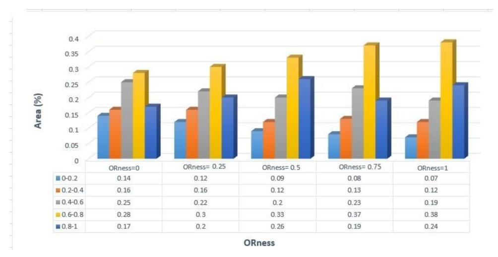
This study provides an innovative collaborative spatial decision support system (SDSS) that aims to ensure an equitable spatial distribution of healthcare services. Evaluating the equality of access to health services across different geographical areas is important, as it requires the analysis of various criteria such as the proximity of health centres and hospitals (HCHs), the quality of services offered, connectivity to primary roads, the availability of public transportation hubs, and the density and distribution patterns of HCHs. This purpose is accomplished via the use of geographic information systems (GIS) and multi-criteria decision analysis (MCDA) methods. The proposed model includes the weights of the criteria, which are determined through the ordered weighted average (OWA) and evaluated based on their ORness, which ranges from 0 to 1. Furthermore, this model is improved by the best–worst fuzzy method (F-BWM). This approach produces a spatial map that clearly shows the equity of healthcare systems in urban environments. The findings show that the maximum score observed in this study was 0.38% (with an ORness value of 1), whilst the minimum score recorded was 0.28%. In the most severe scenario (ORness = 0), over 70% of the region shows different degrees of fairness, ranging from moderate to suitable and very suitable conditions. Governments and health authorities can use this information strategically to allocate resources and address inequities in access to healthcare facilities.
Keywords: volunteered geographic information; healthcare accessibility; spatial decision support system; spatial inequalities; spatial distribution; spatial pattern volunteered geographic information; healthcare accessibility; spatial decision support system; spatial inequalities; spatial distribution; spatial pattern