Article

The Implementation of Integrated Coastal Management in the Development of Sustainability-Based Geotourism: A Case Study of Olele, Indonesia

by
Yohanes Sulistyadi
1,
Ramang H. Demolingo
2,
B. Syarifuddin Latif
2,
Titus Indrajaya
3,
Putu Pramania Adnyana
4 and
Kadek Wiweka
1,5,*
1
Tourism Department, Tourism Polytechnic of Sahid, Jakarta 10220, Indonesia
2
Faculty of Economy dan Business, Universitas Nasional, Jakarta 12520, Indonesia
3
Faculty Management & Business, University of Respati Indonesia, Jakarta 10330, Indonesia
4
Fakultas Ilmu Budaya, Universitas Indonesia, Depok 16424, Indonesia
5
École Doctorale Sociétés, Temps, Territoires (EDSTT) Tourisme, Université Angers, 49100 Angers, France
*
Author to whom correspondence should be addressed.
Sustainability 2024, 16(3), 1272; https://doi.org/10.3390/su16031272
Submission received: 23 October 2023 / Revised: 14 January 2024 / Accepted: 17 January 2024 / Published: 2 February 2024

Abstract

:
The objective of this study is to examine the key determinants involved in formulating a sustainable plan for marine tourist development in the Olele Marine Park region with a specific focus on geotourism, guided by the principles of integrated coastal management (ICM). The current investigation employed descriptive analytical methodologies, utilizing interpretative structural modeling (ISM) as the selected analytical tool. The current research effectively accomplished the development of a spatial use zoning map inside the Olele Marine Park region with a specific focus on its use in the context of geotourism. This study posits that the incorporation of utilization zones, in addition to the existing core zones and sustainable fisheries, is vital for effective design. In addition, the findings of the ISM analysis also indicate that the development of the Olele Marine Park area encompasses a minimum of five elements. These elements consist of primary sub-elements and supporting sub-elements, which were deemed to be independent and exert significant driving forces. The findings of this study have practical implications for the government in formulating sustainable marine tourist development plans. These recommendations primarily focus on the concepts of ICM and are aimed at promoting geotourism.

1. Introduction

Indonesia holds the distinction of being the most extensive archipelagic nation globally. Hence, water resources assume a pivotal function in fostering the economic development of Indonesia. In addition to the utilization of marine resources, a significant number of marine regions in Indonesia have the potential for development as tourism destinations. The marine parks in Indonesia are renowned globally for their exceptional underwater biodiversity, making them very distinguished [1].
The establishment and management of marine park areas necessitate careful consideration, particularly in order to mitigate any potential adverse effects that may arise. In his seminal work, Clark (2018) outlined a comprehensive framework consisting of 15 fundamental principles for effectively managing coastal and marine areas [2,3,4]. These principles encompass various aspects, such as resource systems, the pivotal role of integration, the establishment of a focal point, the delineation of the coastal zone boundary, the conservation of common property resources, addressing the degradation of conservation efforts, the inclusion of all levels of government, understanding the character and dynamics of nature, recognizing the economic benefits, prioritizing conservation as the primary objective, adopting a multiple-use management approach, promoting the utilization of multiple uses, acknowledging traditional management practices, and conducting thorough environmental impact analyses [5,6].
In addition to this, the management of coastal and marine areas must also adhere to the principles of sustainable development as outlined in The Rio Declaration on Environment and Development. The agreement outlined in this document establishes seven key principles that aim to promote sustainable development. These principles encompass the notions of interrelationship and integration, inter- and intra-generational equity, the right to develop with environmental safeguards, the precautionary principle, the polluter-pays principle, transparency, and other process-oriented principles [6,7,8]. Implementing these guidelines is crucial for the destination to maintain long-term viability.
One undersea potential now under development in Indonesia is Olele Marine Park, located in Gorontalo Province. The region in question is renowned for its inherent aquatic attributes and forms an integral component of the geopark development zone. One of the primary obstacles encountered in the advancement of geotourism in areas with delicate ecosystems is the imperative to ensure the long-term viability and preservation of natural resources [9,10]. In addition to the aforementioned considerations, it is imperative for this growth to provide advantages for local communities, encompassing both immediate and enduring timeframes [11,12,13].
The Regional Tourist Development Master Plan (RIPPDA) for Bone Bolango Regency 2011–2031 incorporates the objective of creating a prioritization framework for regional tourist development that safeguards regional attributes and maximizes the sustainable utilization of natural and cultural resources. The Olele Marine Park region encompasses both coastal and marine environments, necessitating a management framework that integrates several sectors and is underpinned by ecological, economic, and social considerations. This approach is commonly referred to as ICM [4,12,13]. The implementation of this particular plan is anticipated to effectively address the prevailing challenges encountered within the Olele Marine Park area. In addition, the implementation of integrated coastal management (ICM) can enhance the empowerment of local residents in coastal areas, an issue often overlooked in development endeavors [14,15]. These challenges mostly pertain to the minimal economic contributions made by community groups responsible for managing tourist attractions in the area. According to Wijaya [13], the occurrence of this phenomenon can be attributed to a deficiency in knowledge and awareness within the community, leading to a limited level of community engagement in regional development.
For scholars and researchers in the field of tourism, this phenomenon serves as a motivation to actively engage in regional development initiatives. Hence, the researchers in the current study employed participatory action research (PAR) methodology [14,15,16], which entailed conducting research activities in a participatory manner within a specific community, namely Olele Village. The aim of this approach was to foster transformative actions, particularly in the development of coastal areas within the village, with the objective of improving living conditions. An obstacle in executing this approach was the inherent tendency of small communities to be insular. Nevertheless, by enlisting the assistance of a local expert in this research, the level of communication with the community was significantly improved, leading to more receptiveness towards this study. The local government also played a crucial role in persuading rural people about the advantages of this study.
This study’s authors endeavored to formulate a strategic plan for the development of the Olele Marine Park region as a geotourism destination, utilizing the principles of ICM. There has been little implementation of the integrated coastal management (ICM) approach in coastal area management or geotourism, as indicated by certain works in the literature [17,18,19]. Nevertheless, this concept has demonstrated considerable success in other instances in other countries [4,20,21]. In addition to the aforementioned objective, this study’s authors also sought to delineate the potential and zoning of the Olele Marine Park region as a geotourism site, utilizing an ICM approach. The researchers aimed to provide priority recommendations that can be implemented by several stakeholders, including local governments as policymakers, industry representatives as partners, and local communities as subjects of development.

2. Literature Review

2.1. Geotourism

According to Newsome and Dowling, the prefix “geo-” in the term geotourism pertains to the study of geology, geomorphology, and the natural resources associated with landscapes, landforms, fossil beds, rocks, and minerals [22,23]. The primary focus is on developing an appreciation for the processes responsible for the formation and existence of these characteristics. The definition provided by those two experts places greater emphasis on the term “geology.” On the other hand, Tourtelott provided a definition of geotourism as a form of tourism that contributes to the preservation and enhancement of the distinctive geographical attributes of the destinations it encompasses. This includes considerations of the environment, cultural aspects, aesthetic qualities, heritage, and the overall well-being of local inhabitants [17,18,19].
In contrast, Dowling [20] provided a definition of geotourism as a form of sustainable tourism that places significant emphasis on the study of the Earth’s development and geological characteristics. This approach aims to foster environmental and cultural comprehension, appreciation, and preservation while also yielding advantages for local communities [19,20,21]. Additionally, the aforementioned resource states geotourism principles, as outlined by Dowling [23], which encompass geologically based, sustainable, geologically instructive, and locally beneficial principles, as well as tourist satisfaction.
This study classified the Olele Marine Park area as a geotourism destination, taking into account these notions and its potential. Geotourism is considered a valuable instrument in achieving sustainable development [24]. Multiple research projects have additionally discovered that this strategy has the capability to offer additional benefits within an economic and social framework [14,15]. Subsequently, this concept will serve as a point of reference in formulating management strategies.

2.2. Integrated Coastal Management (ICM) and Indicators of Sustainable Development in Coastal Areas

The implementation of integrated coastal management, as outlined in Chapter 17 of Agenda 21, emphasizes the significance of the marine environment as a crucial element of the global life support system. This strategy involves the spatial design of marine regions to facilitate the integrated management of both marine and coastal areas. The ongoing population growth and exploitation of endangered natural resources have led to the necessity of managing and protecting marine and coastal areas, as well as developing them in a manner that aligns with their intended purposes. This is crucial for ensuring the sustainability of natural resources with the aim of preserving them for future generations [25,26].
ICM refers to the strategic approach employed in the governance of natural resources and environmental services within coastal and marine regions. This approach entails undertaking a thorough evaluation of the available natural resources and environmental services [4,12]. In addition to this, the management process involves the identification of usage goals and targets, followed by the formulation and execution of plans to effectively manage all utilization activities, with the ultimate aim of attaining optimal and sustainable development [24].
The primary objective of ICM is to attain sustainable development within marine environments through the mitigation of adverse impacts on coastal and marine resources, as well as residential areas [27]. In addition, the maintenance of ecological life and the preservation of the carrying capacity of life-supporting systems for biodiversity in coastal and marine areas are anticipated to be achieved through the implementation of spatial planning strategies for marine areas [28,29,30].
In their study, White et al. [12] identified ten key factors that can be employed to effectively achieve ICM. These factors encompass various aspects, including the connection between management and biophysical changes, the involvement of stakeholders in the decision-making process of ICM, the enhancement of economic returns and income generation, the establishment of a legal and policy framework, the capacity for law enforcement, the maintenance of institutional continuity amidst change, the inclusion of the private sector, the implementation of a successful project exit strategy, the promotion of education and awareness, and the recognition of traditional marine tenure [27].

3. Methods

This study employed a descriptive analytical approach that aimed to address contemporary and practical issues. Descriptive research is the process of describing and presenting an overview of the item under study through the collection of data or samples. This research approach refrains from conducting analysis to draw findings that could be generalized to the broader population [4,14]. The selection of this approach was based on a careful consideration of the specific attributes of the case study and the research context that was chosen. Data accessibility in the majority of rural regions in Indonesia remains highly challenging, with limited availability from the government or other entities. Hence, it is imperative to gather data directly from sources. In addition, those with limited educational attainment may not comprehend the contextual complexities of the topic under discussion.

3.1. Research Location

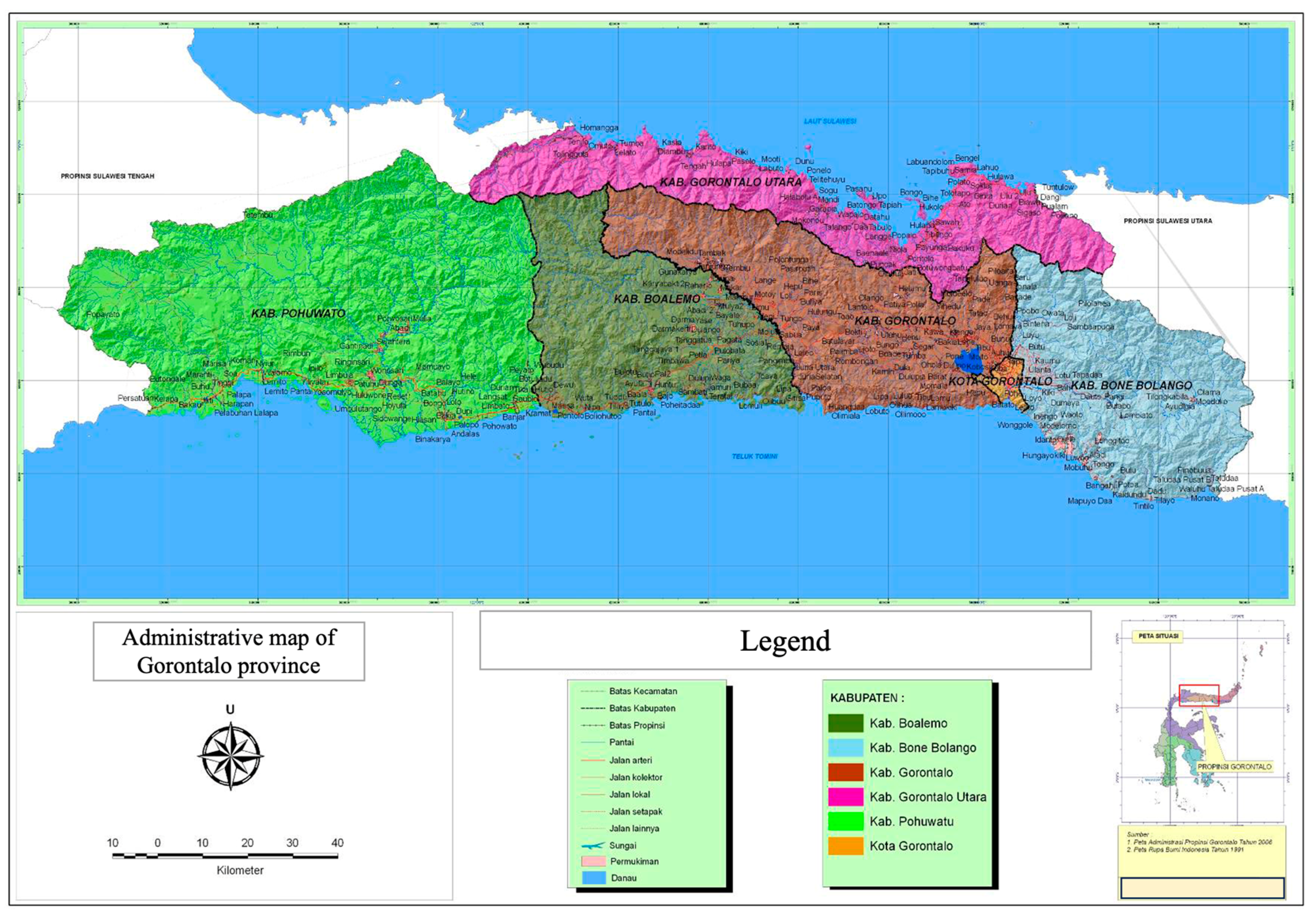
The data collection was conducted in Olele Village, located in the Bone Bolango Regency, over the period spanning from October 2021 to February 2022. The selection of the research location was determined according to the geographical position of the regional government’s geotourism and geopark development initiative, specifically in the Bone Bolango Regency of Gorontalo Province (Figure 1).
From a geographical perspective, Bone Bolango Regency encompasses an expanse of 1984.58 square kilometers, which is divided into 17 sub-districts and 1 preparation sub-district. Bone Bolango Regency accounts for approximately 16.24% of the total area of Gorontalo Province. The topography of this regency is predominantly characterized by elevated terrain, consisting largely of hilly areas. The topographic conditions of the Bone Bolango Regency area can be classified into three categories: land with a plateau (mountainous) surface or a slope greater than 40%, land with hilly (wavy) relief and a moderate morphological texture, and land with a low-relief surface. The area is distributed across the Tapa, Suwawa, and Kabila Districts.
One of the factors determining the selection of this research location was the widespread recognition of this marine park, referred to as “The Hidden Paradise in Sulawesi.” In addition, the marine park is currently in the process of being explored. As a result, the Gorontalo provincial government officially declared it as a regional marine conservation area (RMCA) in 2005.

3.2. Research Participants and Data Collection Techniques

The data-gathering process involved the utilization of focus group discussions (FGDs) [14,15,24] and in-depth interviews [31,32,33], employing structured questionnaires that were developed using ISM, as proposed by Saaty [34,35,36]. This stage was not solely dependent on the number of participants; rather, it placed greater emphasis on the diverse viewpoints and ideas of the participants. In addition, the participants’ perspectives and arguments were individually assessed through interviews to ensure that data saturation was achieved, enhancing confidence.
Table 1 demonstrates that this study aimed to engage all individuals who comprehend the matter of establishing Olele Marine Park as a geopark. The primary objective of disseminating this survey was to gather data from professionals concerning the contextual correlation of each component associated with geotourism development based on ICM in the Olele Marine Park area [4,12]. This research method yields research outcomes in the form of qualitative interpretative analysis, encompassing all the findings and data obtained. The data analysis methodologies and procedures employed in this study were intended to streamline the acquired data, organize it in a systematic manner, and afterwards analyze, evaluate, and derive meaning from it [14,33].
According to Aggarwal et al. & Dhankher [33,36], the process of ISM involves collaborative learning, wherein participants develop structural models to enhance their understanding of intricate aspects of a system program. This is achieved through the deliberate utilization of well-designed visual representations and narratives. The utilization of the ISM technique offers a foundation for conducting program analysis, yielding valuable information that may be effectively utilized in the development of policies and the formulation of strategic plans.
ISM is a modeling technique developed for strategic policy-planning. ISM was first created by Warfield in 1973 [37]; he defined ISM as a computer-assisted learning process that allows individuals or groups to develop maps of complex relationships between various elements involved in complex situations [24,34]. ISM is a sophisticated planning methodology used to identify and conclude various relationships between factors in a particular problem or issue [35,38].
The data collection method known as the ISM methodology employs a specialized questionnaire that is administered to respondents who possess expertise in diverse fields of relevance within the scientific domain. Implementing this approach is crucial, particularly because not all local individuals comprehend the discussed situation. The key informants played vital roles in comprehending the problem and identifying prioritized solutions that could be implemented in this case study. In addition to possessing a high level of competence, an expert must fulfill certain prerequisites.
  • Individuals possessing expertise, discernment, practical know-how, specialized methodologies, and problem-solving capabilities, such as an academic instructor, a consultant, a corporate executive, a government representative, a tourism sector participant, or a local administrative officer.
  • In order to become an expert and effectively complete the questionnaire, it is essential to possess relevant experience and an appropriate educational background and to engage in volunteer activities.
  • According to Eriyatno [39,40], it is important for everyone involved in the study to refrain from having any personal biases or undisclosed motivations related to the subject matter.
Meanwhile, the steps in the ISM Software professional 2.0 are as follows [1,41]:
  • Elucidate the process of program planning.
  • Decompose the software into multiple sub-elements.
  • Establish contextual linkages among the sub-elements within each element.
  • In order to examine the contextual links between sub-elements, experts are required to develop a structural self-interaction matrix (SSIM) for each element. This matrix is filled in by the experts using the symbols V, A, X, and O.
    • V: The sub-element i has an impact on the sub-element j.
    • A: The sub-element i is impacted by the sub-element j.
    • X: There exists a reciprocal relationship between the sub-elements i and j.
    • O: There is no discernible relationship between the sub-elements.
  • Construct a reachability matrix (RM) for each individual element.
    • Once the structural self-interaction matrix (SSIM) has been generated, a reachability matrix table is constructed by assigning the values of 0 or 1 to the letters V, A, X, and O.
    • V: Eij = 1 and Eji = 0.
    • A: Eij = 0 and Eji = 1.
    • X: Eij = 1 and Eji = 1.
    • O: Eij = 0 and Eji = 0.
  • The subsequent analysis of the RM involves identifying level-division choices in accordance with transitivity principles. The process of tabulation involves completing a predetermined format, and it can be facilitated through software.
  • Transform the RM into a cone matrix, undertaking a conversion process.
  • The task at hand involves creating a digraph that reflects the relationship established in the RM and subsequently adjusting the transitive link inside this digraph.
  • Transform the resulting digraph into an ISM model; the element codes should be substituted with corresponding statements.
The objective of the ISM technique is to identify the key aspects that should be examined in the development of the ICM-based geotourism program in the Olele Marine Park area.
The respondents were supposed to utilize the instrument to offer recommendations concerning the priority concerns that necessitate discussion for the purpose of formulating solutions. The process of studying each element involved the subdivision of said element into several sub-elements. This subdivision was informed by input from experts, who provided insights into the contextual links between these sub-elements, thus enabling a more focused and specialized approach.
In the context of formulating the ICM-based geotourism development program in the Olele Marine Park area, the researchers employed a set of five capacity factors, as previously stated:
  • The affected sectors of society.
  • Program needs.
  • The main obstacle.
  • Program objectives.
  • The institutions involved in implementing the program.
The composition of each element within the context of geotourism development based on integrated coastal management (ICM) in the Olele Marine Park area was determined via the interrelationship between its sub-elements (Table 2).
The provided table (Table 3) presents the data utilized in the ISM method, specifically the expert opinions on the contextual relationships between sub-elements within each element of geotourism development based on ICM in the Olele Marine Park area, Bone Bolango Regency. As individuals with specialized knowledge and professional experience, experts provided responses that were anticipated to provide valuable insights and suggestions based on their particular areas of expertise.
This development program has an impact on five sub-elements of the community sector. These sub-elements were identified during the formulation of the program via an FGD. Consequently, the participants were anticipated to express their viewpoints regarding the contextual associations (role levels) among the sub-elements through the completion of the contextual relationship matrix cells for program objectives.
Based on Table 3, the participants were instructed to provide responses similar to the following exemplified instance.
If the program had an impact on the sub-elements of the community sector, specifically fishing operations and the fishermen involved, it was expected that there would be an influence on the livelihoods of the village community. In light of this, the respondent would proceed to complete the matrix cells in the following manner (Table 4).
This procedure was conducted on either all or a set of five predetermined items. In this study, the methods employed to communicate the outcomes of data analysis involved the utilization of descriptive, interpretive, and explanatory approaches to elucidate the obtained data. The methodology employed in this study for presenting the findings of data analysis encompassed either an informal or formal approach.

4. Results and Data Analysis

4.1. The Prospective Cartography and Zoning of the Olele Marine Park Area as a Geotourism Destination Applying Integrated Coastal Management (ICM)

The examination of spatial utilization within the Olele Marine Park region for the purpose of geotourism could be investigated by employing a conservation area zoning framework [20,21]. This approach serves as a method for delineating tourism assets and determining the maximum sustainable visitor load. The proper management of marine ecosystems necessitates the establishment of zoning measures to effectively regulate both aquatic resources and ecological systems. According to the Minister of Maritime Affairs and Fisheries Regulation (PER.30/MEN/2010), which pertains to the Management and Zoning Plans for Marine Protected Areas, the classification of zoning within marine conservation areas can be categorized into a minimum of four zones [4].
The core zone is characterized by its preservation of original natural conditions, encompassing both biotic and physical elements. This particular area remains unaffected or undisturbed by human activities. Hence, it can be concluded that this particular area is fully safeguarded, serving the purpose of preserving the distinct and exclusive biodiversity representation inside the zone. Marine parks typically constitute a central area. The sustainable fisheries zone can be described as a zone that bears a resemblance to the core zone. In this particular area, human intervention, particularly by local residents, has become evident. Within this particular region, a variety of fish species that have not yet reached a state of rarity can still be captured while concurrently upholding the ecological sustainability of the environment. Nevertheless, the exploration and exploitation of fish species and other marine residents is not feasible. Marine parks are typically situated inside areas designated as sustainable fishery zones.
In contrast, the utilization zone refers to a specific area that possesses favorable attributes such as geographical positioning, location, environmental conditions, and inherent potential, rendering it suitable for the development of tourism activities, particularly those centered around natural attractions and other related environmental services. The establishment of utilization zones is vital in order to create employment prospects for local people and enhance their economic success. In addition, several zones are delineated based on specific criteria, thus enabling their utilization for pressing exigencies or for the betterment of the collective [42].
According to the findings derived from interviews conducted with members of the dive club, the topic of discussion revolved around the potential for development and the necessary zoning measures that should be implemented within the Olele Marine Park area in Bone Bolango Regency with the aim of transforming it into a prominent tourist destination. The participants expressed that the area in question had been designated into three distinct zones, namely the core zone, buffer zone, and limited-deployment zone. In addition to this, a community organization dedicated to the oversight and enforcement of regulations had been established. Within the designated buffer zone, it is mandatory for each individual tourist to contribute a donation of 10,000 units of currency. However, the company is unable to furnish this levy due to the village’s inability to produce substantiating evidence of a ticket. According to a dive club business actor (2021), the present region boasts an estimated total of 38 diving destinations.
Conversely, the findings from observational studies assessing the efficacy of marine parks, together with interviews conducted with tourists, revealed that the scenic vistas of sunsets and verdant hills were seen as offering captivating experiences by visitors who accessed these areas by land. Hence, the optimal urban planning model presents a formidable task in preserving the inherent environmental capacity, particularly in mitigating the proliferation of permanent high-rise structures.
The findings from interviews conducted with the tourism office indicate a number of obstacles encountered in the process of establishing zones that may be effectively exploited to address pressing requirements or cater to the community’s interests. Notably, a significant proportion of the community (75%) expressed their unwillingness to undergo relocation as part of the efforts to rejuvenate the area. According to the Tourism Service (2021), one of the primary determinants was the occupation of these individuals as fishermen who rely on marine resources as their principal means of livelihood on a daily basis. Additionally, individuals lack the necessary abilities to swiftly transition between occupations.
However, the Provincial Geopark Team asserted that effective community engagement is crucial for the successful implementation of the zoning plan aimed at transforming the park area into a tourism destination. According to their statement, there is currently a widespread awareness among the general population regarding the importance of environmental conservation. In addition, members of the local community have begun to eschew conventional explosive devices in favor of other methods for procuring fish. One of the factors contributing to the appeal of diving, according to Provincial Geopark Team, is the recognition of and appreciation for the aesthetic allure inherent in the underwater realm, which has the capacity to captivate the interest of divers.
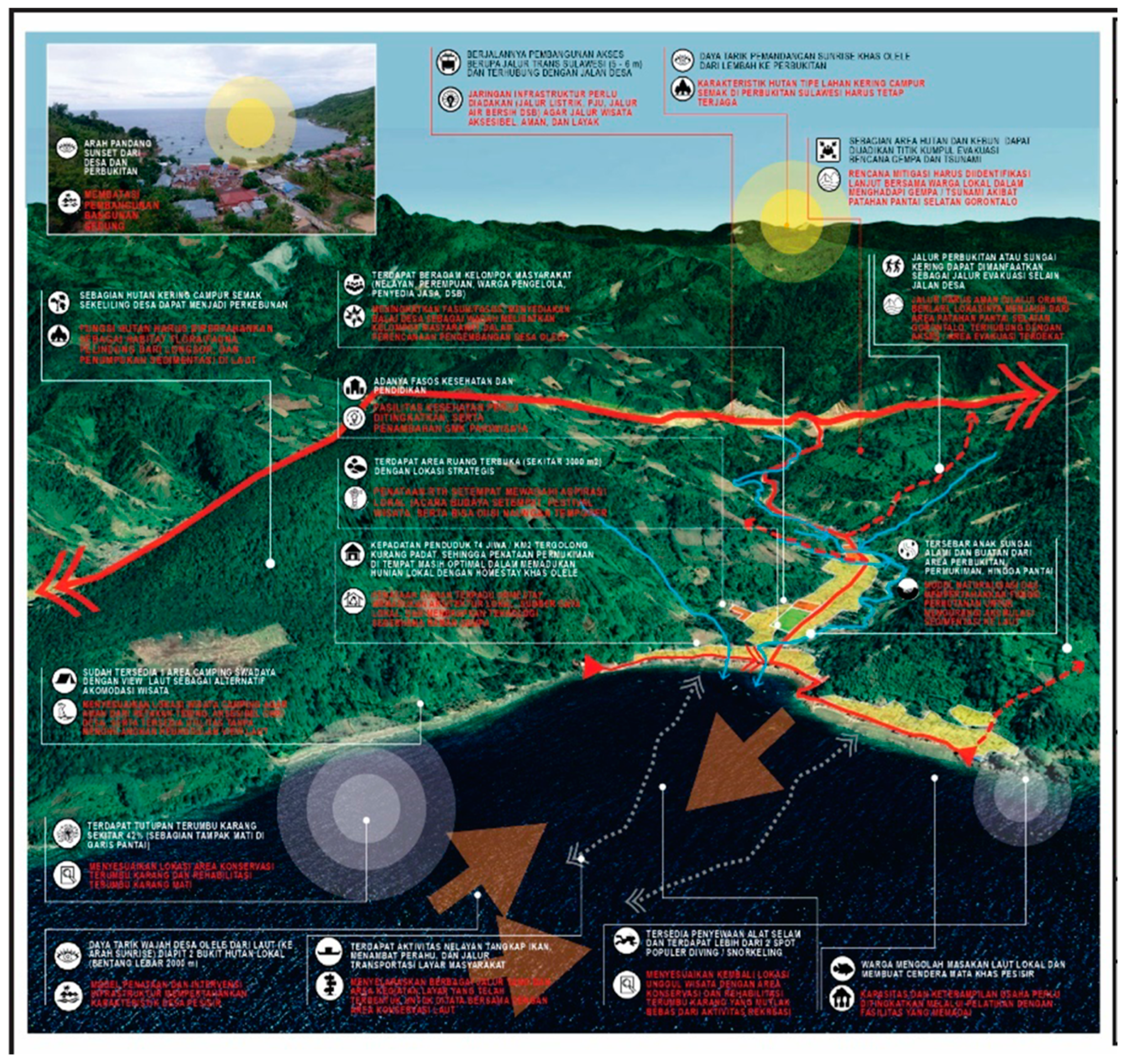
Based on the findings derived from interviews and FGDs, this study reveals that the core zone is a designated area established by the government with the explicit purpose of conserving coral reefs and fish populations while also serving as a dedicated research site. Currently, the core zone exhibits a reasonably high level of maintenance due to the predominant engagement of visitors in estuarine snorkeling activities. In contrast, the core zone is situated at a depth that is quite inaccessible. In addition, the government has undertaken the task of delineating sustainable fishing zones that remain open for fishing operations while adhering to environmentally friendly practices. Furthermore, measures have been implemented to ensure that human activities, such as the operation of fishing vessels and the actions of fishermen, are conducted in a manner that minimizes the contamination of seawater. This study utilizes data analysis techniques to develop an integrated zoning design, as follows (Figure 2).
In addition to prioritizing core areas and sustainable fisheries, this study proposes the identification of maritime tourism zones in regions where fishing activities are still permitted by the government. This area is frequently utilized by several established maritime tourism activities, thus necessitating the necessity for its preservation. In addition to this, it is imperative to incorporate local residents in the planning and organization of this area, particularly to ensure seamless integration with tourist destinations.
In addition to the aforementioned, this study further proposes the development of camping and natural tourism zones situated in elevated regions, wherein pre-existing camping sites are already established. The present area serves as a supplementary component to the maritime tourist sector and has the potential to be further developed into a coastal tourism destination in Olele Village [43,44]. The plantation agricultural zone exhibits significant potential for development within the forested vicinity of the settlement. The proportion of this zone does not exert a dominant influence on the overall forest area, as its purpose is to preserve the integrity of the original forest ecosystem. This preservation effort is expected to have subsequent implications for the process of seawater sedimentation. The zoning plan also takes into consideration the establishment of tourist village settlements, which are designed for low-density structures, including homes for local residents, as well as numerous accompanying tourist amenities. The settlement arrangement focuses on the establishment of guest houses or homestays that are jointly maintained with locals, incorporating earthquake-resistant technology. The designated area is intended to be situated on the northern side of the village road in order to minimize the potential disruption to areas of naturalization and water sources in the foreseeable future.
In addition to this, the present study delineated the naturalization zones inside the river basins adjacent to the site’s river. The optimization of these regions can be achieved through the implementation of green spaces and open areas devoid of buildings. The utilization of this expansive area can be strategically oriented towards the riverside, thus incorporating the presence of coastal rivers into the future advancement of tourist communities. In coastal regions, native forest conservation zones refer to designated areas that actively preserve the presence of indigenous woods. This region holds significant ecological value, as it serves as a habitat for indigenous plant and animal species. Consequently, it can be utilized for the purposes of coastal ecotourism and scientific research [45,46].
In contrast, the village evacuation area encompasses multiple geographical locations. The region in question is geographically linked via a topographically undulating pathway, and it serves as a designated location for the purpose of evacuating individuals onto the Trans Sulawesi Route. The positioning of this region is oriented away from the fault area along the southern shore, with a minimum of two regions located on the northern and southern peripheries of the hamlet. Additionally, this region has the potential to establish connections with undulating pathways leading to the closest rural settlement.
In practical application, it is necessary to modify the zoning of the Olele Marine Park region to align with the principles of ICM and geotourism while also taking into consideration local wisdom and cultural values. This necessitates the translation of global concepts into local languages to facilitate comprehension and implementation among local populations. One strategy that might be considered to be highly effective in elucidating the principles of “glocalization” is the implementation of Tri Hita Karana (THK) in Bali [47,48] and Memayung Hayuni Bawana (MHB) in Java [49,50]. The indigenous knowledge embedded in this local community effectively incorporates global sustainability ideas, employing a straightforward vernacular that is accessible to the local populace. When implementing ICM, it is crucial to consider the distinct characteristics of the Bone Bolango Regency.

4.2. Sustainable Marine Tourism Development Model Based on an Interpretive Structural Modeling (ISM) Approach in Olele Geotourism

Following the findings from the FGD on the prioritization of the ICM-based geotourism development model in the Olele Marine Park area, the researchers proceeded to conduct an ISM analysis [51]. These data were further corroborated by observational findings and several secondary data sources, including government laws at both the central and regional levels.
Empirical observations conducted in the field revealed that the development of this particular area is confronted with a multitude of problems, resulting in a deviation from the anticipated trajectory of advancement. Hence, the outcomes of the FGD led to the development of a strategic plan comprising five key components, namely (i) affected sectors of society, (ii) program needs, (iii) program objectives, (iv) the main obstacle, and (v) the institutions involved in implementing the program.
This research incorporated various development elements, which were further divided into sub-elements. These sub-elements were derived from expert consultations involving six key stakeholders: the Regency Regional Planning Agency, the Provincial Tourism Office, the Gorontalo Province Economic Study, the Development & Empowerment Center, the media, and the Marine Geology Research Center of the Ministry of Energy and Mineral Resources. Additionally, local communities, particularly those engaged in geotourism development, were also involved in the study’s discussions. The findings of this analysis can be characterized in the order that follows.

4.2.1. Affected Sectors of Society

The community sector has been influenced by the development of the Olele Marine Park Area Development Strategy, which is based on Geotourism and Integrated Coastal Management (ICM) principles. This impact may be observed through the presence of five sub-elements. These sub-elements include:
  • A1: Village community livelihoods.
  • A2: Fishing activities (fishermen).
  • A3: Marine tourism activities (diving, snorkeling, and other water sports).
  • A4: Village facilities and infrastructure and the surrounding environment.
  • A5: Business actors (MSMEs) or tourism services.
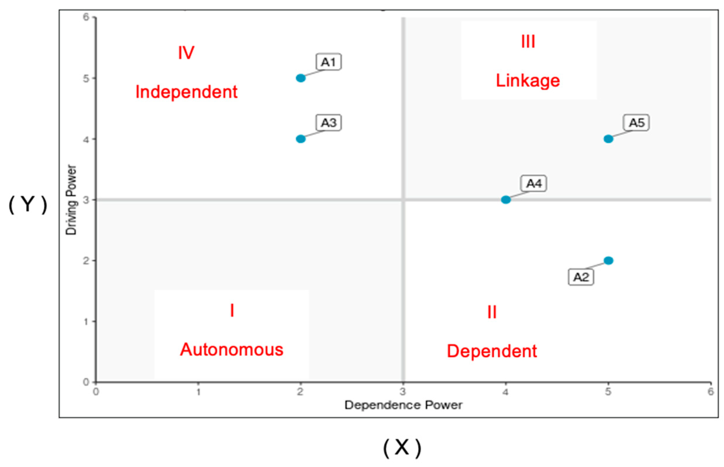
The findings derived from the examination of the data indicate that A1 exhibited the highest level of driver power (5) and the lowest level of dependence (2). This implies that sub-element A1, which pertains to village community livelihoods, exerted a significant influence as a major sub-element. It possessed the largest driver power among the sub-elements, hence exerting a considerable impact on them. Furthermore, sub-element A1 exhibited the lowest level of dependence on the other sub-elements. A3 exhibited the second-highest driving power (4) and the lowest level of reliance (2). This implies that sub-element A3, which encompassed maritime tourism activities such as diving, snorkeling, and other water sports, held the second-most-significant position in terms of its influence on other sub-elements. Additionally, it possessed a relatively high driver power compared to the other sub-elements and exhibited the lowest level of dependence on the other sub-elements.
The driver power with the lowest value (2) and the highest level of dependence (5) was denoted as A2. This implies that sub-element A2, which pertained to fishing operations carried out by fishermen, exhibited the lowest driver power and the highest level of dependence on the other sub-elements. Consequently, all the other sub-elements would have had an impact on A2. The sub-elements A5 and A4, which pertained to business actors (MSMEs)/tourism services and village infrastructure and the surrounding environment, served as linkage components that established connections between these sub-elements, as well as with essential sub-elements in order to affect A2. Figure 3 illustrates the contextual quadrant of the community sectors influenced by development.
The analysis of development’s impact on the community sector revealed the presence of power dynamics and interdependence within the contextual quadrant. This quadrant encompassed two sub-elements, specifically A1 (pertaining to the livelihoods of the village community) and A3 (related to marine tourism activities, such as diving and snorkeling). Both these sub-elements were classified under quadrant IV, denoting their independent nature. In quadrant II, sub-element A2, which pertained to fishing operations carried out by fishermen, was classified as dependent. Sub-elements A5 and A4, which referred to business actors (namely micro, small, and medium enterprises in the tourism sector) and village facilities and infrastructure, as well as the surrounding environment, were categorized inside quadrant III or classified as connections. The hierarchical arrangement of the community sectors influenced by development is depicted in Figure 4, which pertains to the contextual quadrant.
The hierarchical structure image shows that the livelihoods of village communities were the main community sector affected by the development of the Olele Marine Park area as a geotourism destination based on ICM principles. Apart from the livelihoods of village communities that are affected by development, there was a marine tourism activity sector related to business actors (MSMEs)/tourism services. Sub-elements of village infrastructure and the surrounding environment were included in the linkage sub-elements whose roles influenced fishing activities (fishermen).

4.2.2. Program Needs

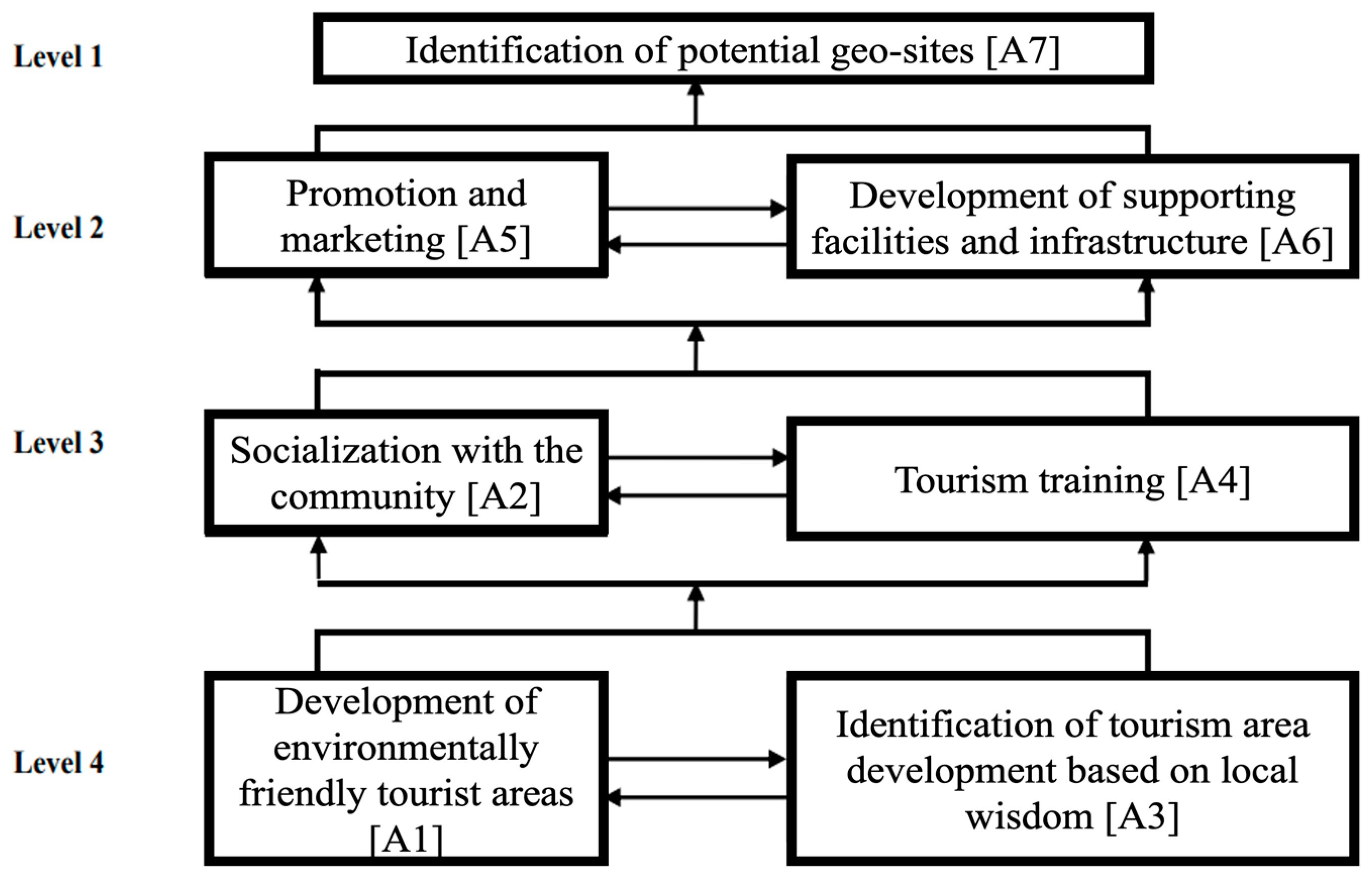
The program criteria encompassed many aspects that pertained to the strategy for the development of the Olele Marine Park region as a geotourism destination, with a foundation rooted in integrated coastal management (ICM) principles. These elements can be further categorized into seven sub-parts, as follows:
  • A1: The development of environmentally friendly tourist areas.
  • A2: Socialization with local communities.
  • A3: The identification of the development of tourist areas based on local wisdom.
  • A4: Tourism training.
  • A5: Promotion and marketing.
  • A6: The development of supporting facilities and infrastructure.
  • A7: The identification of potential geosites.
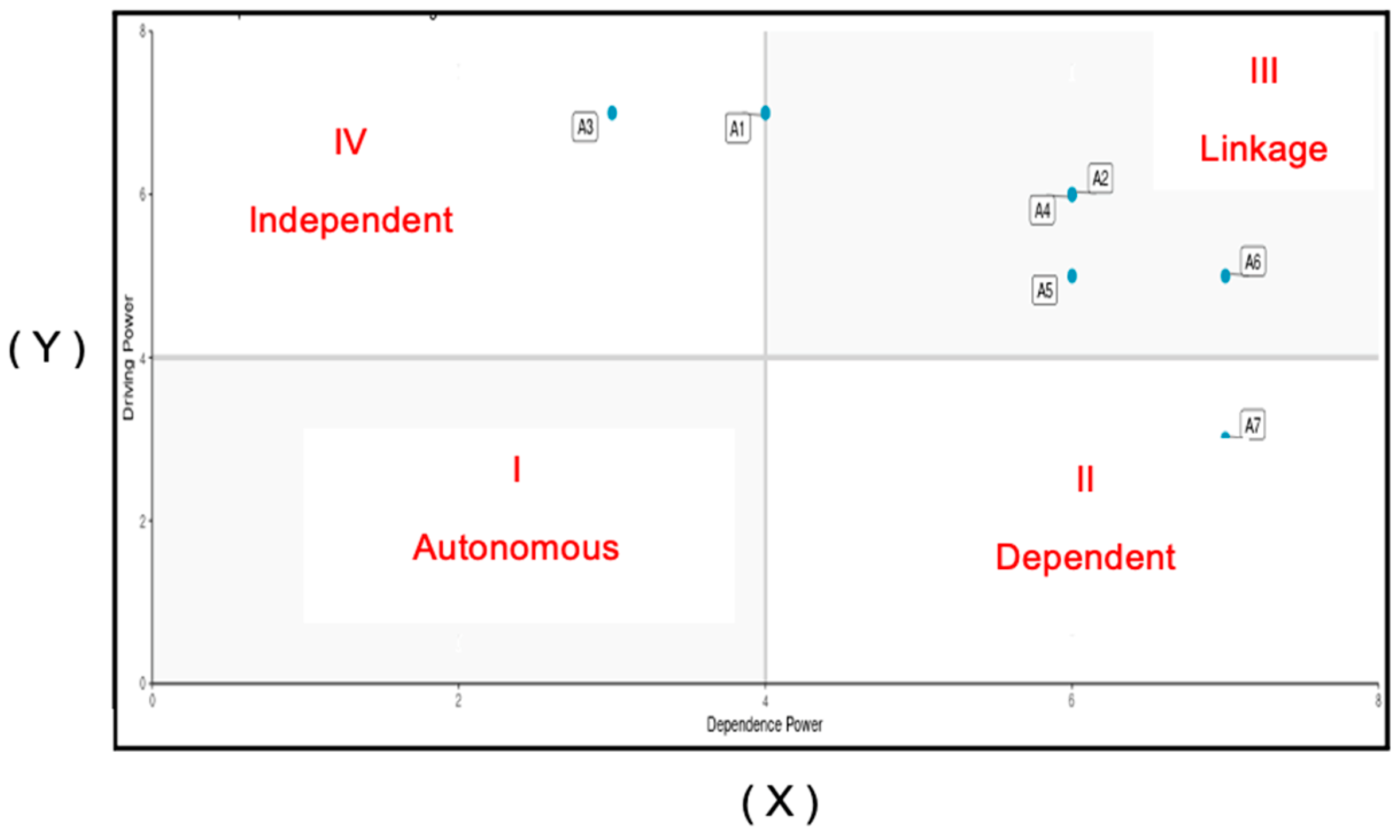
The findings derived from the analysis of the data indicated that A3 exhibited the greatest driver power score of 7, coupled with the lowest level of reliance at 3. Similarly, A1 had the highest driver power score of 7 alongside the second-lowest level of dependence at 4. This implies that sub-elements A3 (the identification of tourism area development based on local wisdom) and A1 (the development of environmentally friendly tourist areas) were crucial sub-elements that exhibited the highest driver power, providing support to the other sub-elements while having the least reliance on them.
The driver power with the lowest value (3) and the highest level of dependence (7) was denoted as A7. This implies that sub-element A7, which pertained to the identification of geosite potential, exhibited the lowest driving power and the highest level of dependence on the other sub-elements. Consequently, all the sub-elements were expected to provide support to A7. The sub-elements A2, A4, A5, and A6, namely socialization with local populations, tourism training, promotion and marketing, and the development of supporting facilities and infrastructure, served as linkage components that established connections between the sub-elements themselves and with essential sub-elements in order to provide support for A7. Figure 5 illustrates the contextual quadrant of community sectors influenced by development.
The program demands could be categorized into several quadrants, depending on their contextual characteristics. In this case, the power and dependence drivers fell under quadrant IV, which was characterized by independence. This quadrant consisted of two sub-elements, namely A3 (the identification of local-wisdom-based tourism area development) and A1 (the development of environmentally friendly tourist areas). In the context of potential geosite identification, sub-element A7 was categorized as being in quadrant II, which was commonly referred to as the dependent quadrant. The sub-elements A2, A4, A5, and A6, namely socialization with local populations, tourism training, promotion and marketing, and the development of supporting facilities and infrastructure, fell within quadrant III, constituting connections. Figure 6 presents a hierarchical arrangement of program demands within the contextual quadrant.
The hierarchical structure diagram illustrates that the primary program requirement for establishing the Olele Marine Park area as a geotourism destination, based on integrated coastal management (ICM) principles, is the identification of tourist places that include local expertise and promote ecologically friendly practices. One of the sub-elements that could be identified within this context was the process of socializing with local populations. This involves engaging with the residents of a particular destination, understanding their culture, customs, and traditions, and fostering positive relationships. Another sub-element is tourism training, which encompasses the development of knowledge and skills necessary for individuals involved in the tourism industry to effectively carry out their roles and responsibilities. Finally, promotion and marketing formed another sub-element, which involved the strategic dissemination of information, and the integration of supporting facilities and infrastructure was encompassed within the interrelated sub-elements (linkages) that connected the establishment of local-wisdom-driven tourism area development and the creation of sustainable tourism areas in order to facilitate the identification of geosite potential.

4.2.3. Program Objectives

The program objective elements of the Olele Marine Park Area Development Strategy, which is based on geotourism and integrated coastal management (ICM) principles, encompass eight sub-elements. These sub-elements are as follows:
  • A1: The promotion of integrated regional development.
  • A2: The protection or conservation of aquatic ecosystems.
  • A3: The encouragement of income-generating activities for local communities and regional governments.
  • A4: Increasing local community participation/involvement.
  • A5: Connecting with the aspiring Gorontalo geopark.
  • A6: Developing or encouraging a sustainable management model for tourism potential.
  • A7: Opportunities to invest in the tourism sector.
  • A8: Becoming a special-interest tourist attraction.
The findings derived from the examination of the data indicated that A1 exhibited the highest level of driver power, scoring 8, while simultaneously displaying the lowest level of reliance, scoring 2. This implies that sub-element A1, which pertained to the promotion of integrated regional development, exerted the highest driver power among the sub-elements. It played a significant role in facilitating the achievement of goals associated with the other sub-elements while exhibiting the lowest level of dependence on these other sub-elements. A4 was identified as the driver with the second-highest power (7) and the second-lowest level of dependence (4). This implies that sub-element A4, which pertained to the increase of local community participation and involvement, exerted the second-most-significant driver power among the major sub-elements. It played a crucial role in the attainment of goals associated with other sub-elements and exhibited a relatively low level of dependence on the other sub-elements, ranking second in terms of this attribute.
The driver power with the lowest value (3) and the highest level of dependence (8) was denoted as A8. This implies that sub-element A8, which pertained to being a tourist attraction of exceptional interest, had the lowest level of driving power and the highest level of interdependence with the other sub-elements. Consequently, all the sub-elements were expected to contribute towards the attainment of aim A8. A6 was identified as having the second-lowest driving power (7) and the second-highest dependence (4). This implies that sub-element A6, which pertained to the establishment and promotion of a sustainable governance model for tourist potential, was the second sub-element that contributed to the attainment of program objectives in conjunction with the other sub-elements.
The sub-elements A2, A3, A5, and A7, namely the protection and conservation of aquatic ecosystems, the encouragement of income-generating activities for local communities and regional governments, the connection with the aspiring Gorontalo geopark, and opportunities to invest in the tourism sector, served as connecting elements or linkages. These linkages connected sub-element 1 with other sub-elements and key sub-elements, thereby contributing to the achievement of the A8 objectives. Figure 7 illustrates the contextual quadrant of community sectors affected by development.
The program objectives could be analyzed within the contextual quadrant framework, revealing the presence of power and dependence drivers. These drivers were further categorized into two sub-elements, specifically A1 (promote integrated regional development) and A4 (increase the participation/involvement of local communities). Both sub-elements fell into quadrant IV, demonstrating their independence. In the present context, sub-elements A8, which pertained to the development of a particular interest tourist attraction, and A6, which concerned the establishment or promotion of a sustainable tourism potential governance model, could be classified as falling under quadrant II or the dependent quadrant. The sub-elements A2, A3, A5, and A7, which pertained to the protection and maintenance of aquatic habitats, the promotion of income-generating activities for local communities and regional governments, the establishment of connections with the prospective Gorontalo geopark, and the identification of opportunities for investment in the tourism industry, were classified within quadrant III, also known as the connectivity quadrant. Figure 8 presents a hierarchical arrangement of program objectives within the contextual quadrant.
The hierarchical structure diagram illustrates that the primary program objective was the promotion of integrated development within the area. Additionally, it highlights the objective of increasing participation and involvement for local communities, which played a significant role in achieving the overall goal of developing the Olele Marine Park area as a geotourism destination based on integrated coastal management (ICM) principles. The sub-element pertained to the protection and maintenance of aquatic habitats, as well as the promotion of income-generating activities among local communities and regional governments. The connection between the aspiring Gorontalo geopark and opportunities for investment in the tourism sector could be observed through the sub-element linkage. This linkage encompassed the promotion of integrated regional development and the increase in community participation and involvement at the local level. These efforts aimed to support the geopark in becoming a special-interest tourist attraction and to establish a sustainable governance model for its tourism potential.

4.2.4. The Main Obstacle

The primary limiting factors of the Olele Marine Park Area Development Strategy, which is based on geotourism and follows integrated coastal management (ICM) principles, encompassed seven sub-elements. These sub-elements were responsible for causing certain effects or conditions within the strategy.
  • A1: The budget for developing tourist destinations and attractions.
  • A2: The awareness of village communities and stakeholders.
  • A3: Regulations.
  • A4: The sustainable management of post-development tourist destinations.
  • A5: The impact of tourism on the environment.
  • A6: Low community participation.
  • A7: A lack of collaboration with universities and research institutions.
The findings derived from the examination of the data indicated that A1 exhibited the highest driving power (8) and the lowest level of dependence (2). This implies that sub-element A1, which pertained to the budget allocated for the development of tourist sites and attractions, was the primary limiting factor, having the greatest influence on the other sub-elements while also exhibiting the least reliance on the other sub-elements. The drivers labeled A3 corresponded to the second-highest power (6) and the second-lowest dependence (2). This implies that sub-element A3 (regulation) was the second primary limiting factor sub-element, possessing the second-highest influential driver, which influenced the other sub-elements and exhibited the second-lowest interdependence with them. Driver A2 was classified as the third-highest in terms of power (5) and the third-lowest in terms of reliance (3). This implies that sub-element A2, which pertained to the awareness of village communities and stakeholders, constituted the third crucial sub-element within the primary obstacle. It was driven by the third high-power factor, resulting in the influence of the other sub-elements, while exhibiting a low dependence on the other sub-elements.
A7 exhibited the lowest driver power (2) and the highest level of dependence (7). This implies that sub-element A7, which pertained to the lack of interaction with universities and research institutions, exhibited the lowest driver power and demonstrated the largest level of dependence on the other sub-elements. Consequently, all the sub-elements had the potential to contribute to the occurrence of A7. A6 was characterized by the second-lowest driver power (2) and the second-highest dependence (6). This implies that sub-element A6, namely low community participation, was the second sub-element that arose as a result of constraints associated with earlier sub-elements. The A5 driver was ranked as the third-lowest in terms of power (3) and the second-highest in terms of reliance (5). This implies that sub-element A5, which pertained to the impact of tourism on the environment, was the third sub-element resulting from the primary restrictions alongside the remaining sub-elements.
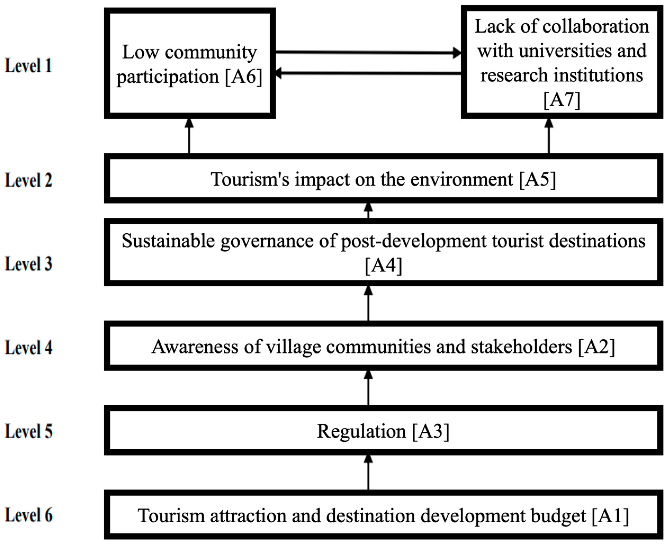
Sub-element A4, which pertained to the sustainable governance of post-development tourist locations, served as a connecting element or linkage that established connections between the other sub-elements, as well as with crucial sub-elements, hence influencing the occurrence of sub-elements A7, A6, and A5. The primary hindrance within the contextual quadrant is depicted in Figure 9.
According to the contextual quadrant analysis, the primary factors that impose limitations are the drivers of power and reliance. These drivers consist of three sub-elements, specifically A1 (the allocation of funds for the development of tourism destinations and attractions), A3 (regulatory measures), and A2 (awareness among village populations and stakeholders). These sub-elements were categorized in quadrant IV, denoting their independence. In quadrant II, subcomponents A7 (insufficient partnerships with universities and research institutes), A6 (limited community participation), and A5 (the environmental impact of tourism) were categorized as dependent. Sub-element A4, which pertained to the sustainable governance of post-development tourist locations, fell within quadrant III, sometimes known as the linking quadrant. Figure 10 presents a hierarchical arrangement of program limitations within the contextual quadrant.
The hierarchical structure diagram illustrates that the primary limitation in establishing the Olele Marine Park region as a geotourism destination based on integrated coastal management (ICM) principles was the funding allocated for the development of tourist destinations and attractions. This was followed by regulatory limits and the level of knowledge among village residents and stakeholders involved in the development process. The post-development sustainable management of tourist destinations encompasses various sub-elements that are interconnected. These sub-elements include linkages, which connect key sub-elements, main constraints, and budget allocations for developing tourist destinations, and factors that contribute to obstacles, such as the lack of collaboration with universities and research institutions.

4.2.5. Institutions Involved in Implementing the Program

The significance of several actors in the development of the Olele Marine Park area as a geotourism destination cannot be overstated. The Provincial Geopark Team posited that the cooperation of both government and community is crucial for the successful development of this area. The policies of this regional development strategy encompass nine sub-elements that pertain to institutional aspects. These sub-elements include the following:
  • A1: The village community.
  • A2: Business actors or tourism services.
  • A3: The regional government.
  • A4: The village government.
  • A5: The private sector.
  • A6: Academics.
  • A7: Non-governmental organizations (NGOs).
  • A8: Local community groups activating MSMEs.
  • A9: The organization of marine tourism enthusiasts.
The findings derived from the examination of the data indicated that A1 exhibited the highest level of driver power, scoring 9, and the lowest level of reliance, scoring 1. This implies that sub-element A1, referred to as the village community, held a significant position within the institution engaged in policy-making. It possessed the largest driver power among all the sub-elements, indicating its influential role in supporting the other sub-elements. Furthermore, it exhibited the lowest level of dependence on the other sub-elements. The driving power of A8 was the lowest at 2.5, but its reliance was the highest at 9. This implies that sub-element A8, which pertained to local community groups for MSME mobilization, exhibited the lowest driver power and the highest dependence on the other sub-elements. Consequently, all the other sub-elements were expected to provide support to A8.
The sub-elements A7, A9, A2, A3, A4, A6, and A5, which represented NGOs, marine tourism enthusiast organizations, tourism businesses/services, the regional government, the village government, academics, and the private sector, served as the connecting institutions that established linkages between sub-elements and key sub-elements in order to provide support for A8. The primary hindrance within the contextual quadrant is depicted in Figure 11.
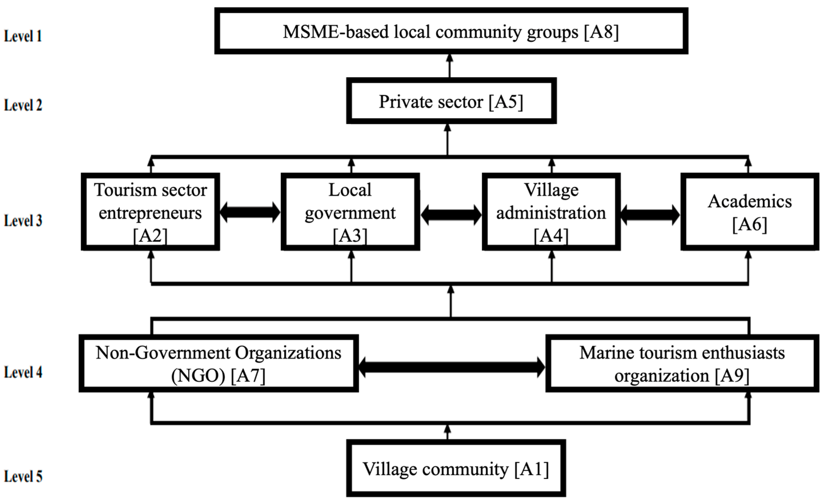
The program needs, as determined via the contextual quadrant analysis, exhibited power and dependence drivers with one specific sub-element, referred to as A1 (the village community), falling under quadrant IV, denoting an independent status. In the present context, sub-element A8, which pertained to the activation of micro, small, and medium enterprises (MSMEs) by local community groups, was classified within quadrant II, denoting a state of dependency. Sub-elements A7, A9, A2, A3, A4, A6, and A5, which represented NGOs, marine tourism enthusiast organizations, tourism businesses/services, the regional government, the village government, academia, and the private sector, respectively, were classified as belonging to quadrant III or constituting connections. The hierarchical arrangement of institutions participating in policy-making is depicted in Figure 12, particularly within the contextual quadrant.
The hierarchical structure diagram illustrates that the village community served as the primary institution responsible for facilitating participation in the policy-making process for the development of the Olele Marine Park area as a geotourism destination, guided by the principles of integrated coastal management (ICM). The sub-elements encompassing NGOs, marine tourism organizations, tourism businesses/services, the local government, the village government, academics, and the private sector were integral components that connected key sub-elements within village communities. These sub-elements played a crucial role in supporting local community groups and MSME activators.

5. Discussion

The Proposed Strategy for the Advancement of the Olele Marine Protected Area as a Geotourism Destination, Grounded in the Principles of Integrated Coastal Management (ICM)

The findings of the ISM analysis indicated that the development of the Olele Marine Park area as a geotourism destination, based on ICM principles, comprised five distinct elements. These elements consisted of primary sub-elements and supporting sub-elements, which were deemed to be independent and possessed significant driver power. Several sub-element conclusions could be drawn from the examination of the ISM.
  • Affected sectors of society:
    • A1 (village livelihood).
    • A3 (marine tourism activities (diving, snorkeling, etc.)).
  • Program needs:
    • A3 (the identification of tourism area development based on local wisdom).
    • A1 (the development of environmentally friendly tourist areas).
  • Program objectives:
    • A1 (the promotion of integrated regional development).
    • A4 (increasing local community participation/involvement).
  • The main obstacle:
    • A1 (the budget for developing tourist destinations and attractions).
    • A3 (regulation).
    • A2 (village community and stakeholder awareness).
  • The institutions involved in implementing the program:
    • A1 (the village community).
The primary sub-components or key elements were derived from the results of the ISM analysis, which included the final reachability matrix, contextual relationship quadrants, and hierarchical elements. The primary components of the community sector affected by development encompassed the sustenance of rural communities and the engagement in marine tourist endeavors, such as diving, snorkeling, and various aquatic recreational activities.
According to Yulianda [27,37,43], the notion of marine tourism encompasses a range of activities that can be potentially developed:
  • Recreation both at the beach and at sea.
  • Diving tourism in seawater and snorkeling tourism.
  • Lodging locations, such as resorts and hotels.
  • Glass boats, submarines, surfing, jet skis, and banana boats.
  • Ecosystem tourism with fishermen’s tourist boats, island tourism, educational tourism, and fishing tourism.
  • Animal tourism, such as seeing turtles, dugongs, whales, dolphins, birds, mammals, and crocodiles.
According to Government Regulation no. 60 of 2007, which pertains to the conservation of fish resources, the interdependence of marine tourism and marine parks with marine conservation zones is emphasized [52,53,54]. Water and marine conservation areas can be characterized as bodies of water that are afforded protection and managed through the implementation of zoning system management criteria. These areas are particularly valuable for their contribution to fish resource management and their role in preserving a sustainable environment. Hence, it is imperative to establish zones dedicated to efficient water conservation. The objective is to offer advantages, encompassing social, cultural, and economic aspects, to the community residing in the vicinity.
Conversely, the primary constituent components of program needs encompass the discernment of tourism area development rooted in local wisdom, as well as the advancement of tourism areas that prioritize environmental sustainability. The primary sub-elements encompassed within the program objectives include the facilitation of integrated regional development and the enhancement of engagement and involvement among local communities. The primary limiting factors are the financial resources allocated for the development of tourist destinations and attractions, as well as the regulatory framework and the level of knowledge and involvement among village residents and stakeholders. Village communities constitute the primary sub-elements of institutions engaged in policy formulation and implementation.
The aforementioned sub-elements serve as a point of reference for the thoughtful formulation of a plan aimed at the development of the Olele Marine Park area as a geotourism destination, in accordance with the principles of ICM. This research aimed to develop a strategy for the Olele Marine Park area’s geotourism based on ICM principles. The strategy was formulated by considering the outcomes of the ISM and the analysis of Regional Tourism Development (RIPPDA) for Bone Bolango Regency from 2011 to 2031. Additionally, the master plan for the Olele Marine Park area and expert opinions were taken into account during the strategy formulation process [43,44].

6. Conclusions and Implications

The present work effectively developed a spatial use zoning map within the Olele Marine Park area with a focus on its potential for geotourism. This study posits that the incorporation of utilization zones, in addition to the existing core zones and sustainable fisheries, is crucial to the design process. The use category encompasses many zones, such as maritime tourism zones, camping and natural tourism zones, plantation agriculture zones, tourist village residential zones, naturalization zones for watersheds, native forest protection zones, and village evacuation zones. In practical terms, it is necessary to adapt the zoning of the Olele Marine Park area as an ICM-based geotourism site to align with local wisdom and cultural values. Consequently, it is imperative to effectively communicate and adapt the overarching global ideas into local languages, thereby facilitating comprehension and successful implementation with local groups. One strategy that can be considered highly effective is the comprehensive exploration and elucidation of the principles and significance of “glocalization.” The indigenous knowledge system effectively incorporates universal sustainability concepts through the use of accessible language that is readily comprehensible to the local populace. When implementing ICM, it is crucial to consider the distinctiveness of Bone Bolango Regency. In addition, the findings of the ISM analysis also indicate that the development of the Olele Marine Park area as a geotourism destination, based on ICM principles, encompasses a minimum of five elements. These elements consist of primary sub-elements and supporting sub-elements, which were deemed to be independent and to exert significant driving forces. The two components that fell under the category of community sectors affected by development were village community livelihoods and maritime tourism activities. In addition to the aforementioned points, it is imperative to identify several programmatic demands, such as the establishment of tourism regions that are rooted in local expertise and the creation of environmentally sustainable tourist destinations. However, it is crucial to prioritize a number of program objectives, such as the promotion of integrated regional development and the enhancement of local community participation and involvement. Several key challenges have been highlighted, namely budgetary considerations, regulatory constraints, and limited knowledge among village communities and stakeholders. This study additionally discovered that village communities play a significant role in formulating development policies. The findings of this study offer potential value for various stakeholders, with particular relevance to the government. These findings can serve as valuable recommendations for the formulation of sustainable marine tourist development strategies in the Olele Marine Park region with a specific focus on geotourism concepts rooted in ICM. One potential restriction of this study is its exclusive reliance on the ISM approach for data analysis. Hence, it is anticipated that forthcoming studies will be able to use diverse analytical methodologies in a more complete fashion, for instance, an AHP approach or any qualitative technique.
The findings of this research have substantial practical implications for the local government’s efforts to develop the Olele Marine Park area into a sustainable tourist destination. Hence, the suggestions derived from this study will serve as the foundation for evaluations by all parties involved in order to ascertain the suitable course of action for development.

Author Contributions

Conceptualization, Y.S.; Methodology, K.W.; Validation, B.S.L.; Formal analysis, T.I.; Investigation, R.H.D.; Writing—review & editing, P.P.A. All authors have read and agreed to the published version of the manuscript.

Funding

This research received no external funding.

Institutional Review Board Statement

Not applicable.

Informed Consent Statement

Not applicable.

Data Availability Statement

No new data were created or analyzed in this study. Data sharing is not applicable to this article.

Conflicts of Interest

The authors declare no conflicts of interest. The funders played no role in the design of the study, in the collection, analyses, or interpretation of data, in the writing of the manuscript, or in the decision to publish the results.

References

  1. Demolingo, R.H.; Lanya, I.; Paturusi, S.A.; Sunarta, I.N.; Wiweka, K. Strategy for icm-based geotourism development: Case study of the olele marine protected area, indonesia. J. Southwest Jiaotong Univ. 2022, 57, 5. [Google Scholar] [CrossRef]
  2. Clark, J.R. Coastal Zone Management Handbook; CRC Press: Boca Raton, FL, USA, 2018. [Google Scholar]
  3. Clark, J.R. Coastal zone management for the new century. Ocean Coast. Manag. 1997, 37, 191–216. [Google Scholar] [CrossRef]
  4. Fang, Q.; Ma, D.; Zhang, L.; Zhu, S. Marine functional zoning: A practical approach for integrated coastal management (ICM) in Xiamen. Ocean Coast. Manag. 2021, 207, 104433. [Google Scholar] [CrossRef]
  5. Atzori, R.; Fyall, A.; Miller, G. Tourist responses to climate change: Potential impacts and adaptation in Florida’s coastal destinations. Tour. Manag. 2018, 69, 12–22. [Google Scholar] [CrossRef]
  6. Cicin-Sain, B. Sustainable development and integrated coastal management. Ocean Coast. Manag. 1993, 21, 11–43. [Google Scholar] [CrossRef]
  7. Cicin-Sain, B.; Knecht, R.W.; Jang, D.; Fisk, G.W. Integrated Coastal and Ocean Management: Concepts and Practices; Island Press: Washington, DC, USA, 1998. [Google Scholar]
  8. Setiawan, B.; Wiweka, K. A study of the tourism area life cycle in Dieng Kulon village. Pertanika J. Soc. Sci. Humanit. 2018, 26, 271–278. [Google Scholar]
  9. Boley, B.; Nickerson, N.; Bosak, K. A Critical Examination Exploring the Differences between Geotourism and Ecotourism. 2016. Available online: https://scholarworks.umass.edu/ttra/2009/Abstracts/1/ (accessed on 15 May 2023).
  10. Ernawati, N.M.; Sitawati, A.A.R.; Muliati, N.K. Batur toward sustainable tourism development-a community-based geotourism case from Bali in Indonesia. J. Environ. Manag. Tour. 2018, 9, 291–297. [Google Scholar] [CrossRef]
  11. Wijaya, R. Meningkatkan Peranserta Masyarakat Desa Olele Dalam Upaya Mendukung Pengembangan Wisata Perdesaan. academia.edu. 2012. Available online: https://d1wqtxts1xzle7.cloudfront.net/38390185/Artikel-libre.pdf?1438784938=&response-content-disposition=inline%3B+filename%3DMeningkatkan_Peranserta_Masyarakat_Desa.pdf&Expires=1705829471&Signature=QdQj3IFNEyMKfk2mg2x6CT-4YX1Cb0-mJOxFVK4DbeS9gj~eG6ud5SSknR4EErGkSBF5Uy3Uh5qAWaEus09WFnIfrDT-t7eZHadegz9Al~~374~ApNNHoBFIj7zNeUns-EZ8CxdHKMVYSD-a-uabNLTjt5xxBWVp6IzGHKajP6l0bNkYxOZzXbhPdgsJRSnhXBP3aZ8Cdk3MkS0ZMHJxQk7h4HMCi7sA8l1rNDw1OB9BPaOkOLYSdAFknodXzq57k3w18G48xHfu3dh7W9irVMkvjt~8xaBRCKnghXLljAHGL0h8EfQAdmNYmWjaW9RQqn3525v8dvR2GSOjTU01og__&Key-Pair-Id=APKAJLOHF5GGSLRBV4ZA (accessed on 20 June 2023).
  12. White, A.T.; Christie, P.; D’Agnes, H.; Lowry, K.; Milne, N. Designing ICM projects for sustainability: Lessons from the Philippines and Indonesia. Ocean Coast. Manag. 2005, 48, 271–296. [Google Scholar] [CrossRef]
  13. Wijaya, P.; Kawiana, I.; Suasih, N.; Hartati, P.; Sumadi, N. SWOT and MICMAC analysis to determine the development strategy and sustainability of the Bongkasa Pertiwi Tourism Village, Bali Province, Indonesia. Decis. Sci. Lett. 2020, 9, 439–452. [Google Scholar] [CrossRef]
  14. Scheelbeek, P.F.D.; Hamza, Y.A.; Schellenberg, J.; Hill, Z. Improving the use of focus group discussions in low income settings. BMC Med. Res. Methodol. 2020, 20, 287. [Google Scholar] [CrossRef]
  15. Zacharia, B.; Pai, P.K.; Paul, M. Focus Group Discussion as a Tool to Assess Patient-Based Outcomes, Practical Tips for Conducting Focus Group Discussion for Medical Students—Learning with an Example. J. Patient Exp. 2021, 8, 237437352110342. [Google Scholar] [CrossRef] [PubMed]
  16. Jonker, J.; Pennink, B. The Essence of Research Methodology: A Concise Guide for Master and Ph.D. Students in Management Science; Springer: Berlin/Heidelberg, Germany, 2010. [Google Scholar]
  17. Nugraha, A. Integrated coastal management in the current regional autonomy law regime in Indonesia: Context of community engagement. Aust. J. Marit. Ocean Aff. 2023, 1–20. [Google Scholar] [CrossRef]
  18. Wijayanti, H.; Marfai, M.A.; Mei, E.T.W. Collaboration practice on ecosystem-based disaster risk reduction in the coastal area of Semarang City, Indonesia. In Proceedings of the Sixth International Symposium on LAPAN-IPB Satellite, Bogor, Indonesia, 17–18 September 2019; pp. 469–476. Available online: https://www.spiedigitallibrary.org/conference-proceedings-of-spie/11372/113721F/Collaboration-practice-on-ecosystem-based-disaster-risk-reduction-in-the/10.1117/12.2539059.short (accessed on 25 December 2023).
  19. Damar, A.; Solihin, A.; Kurniawan, F.; Al Amin, M.A. Effectiveness of ICM system and its contribution to local capacity development: Case study in West Papua Province. IOP Conf. Ser. Earth Environ. Sci. 2023, 1260, 012043. Available online: https://iopscience.iop.org/article/10.1088/1755-1315/1260/1/012043/meta (accessed on 25 December 2023).
  20. Gillgren, C.; Støttrup, J.G.; Schumacher, J.; Dinesen, G.E. Working together: Collaborative decision making for sustainable Integrated Coastal Management (ICM). J. Coast. Conserv. 2019, 23, 959–968. [Google Scholar] [CrossRef]
  21. Gumede, M. Integrated Coastal Management (ICM) Governance and its Implementation in South Africa. Afr. J. Bus. Econ. Res. 2022, 17, 237–253. [Google Scholar] [CrossRef]
  22. Braun, V.; Clarke, V.; Boulton, E.; Davey, L.; McEvoy, C. The online survey as a qualitative research tool. Int. J. Soc. Res. Methodol. 2021, 24, 641–654. [Google Scholar] [CrossRef]
  23. Cipta, H. Completion of Matrix Inversions Using Elementary Matrix Inverse Multiplication Method. Int. J. Sci. Technol. Manag. 2020, 1, 37–45. [Google Scholar] [CrossRef]
  24. Yulianti, T.; Sulistyawati, A. Online Focus Group Discussion (OFGD) Model Design in Learning. 2021. Available online: https://books.google.com/books?hl=id&lr=&id=6Hg6EAAAQBAJ&oi=fnd&pg=PA226&dq=how+to+conduct+Focus+Group+Discussions+(FGDs)&ots=-eneo1CRpv&sig=yl20aePpcLWstEhyJI1lB0Wxrew (accessed on 25 December 2023). [CrossRef]
  25. Dowling, R.K.; Newsome, D. Geotourism; Routledge: London, UK, 2006. [Google Scholar]
  26. Dowling, R.; Newsome, D. Geotourism a global activity. Glob. Geotourism Perspect. 2010, 1–17. [Google Scholar] [CrossRef]
  27. Martini, G.; Alcalá, L.; Brilha, J.B.; Lantria, L.; Sá, A.; Tourtellot, J. Reflections About the Geotourism Concept; Associação Geoparque Arouca (AGA): Arouca, Portugal, 2012. [Google Scholar]
  28. Newsome, D.; Dowling, R. The Scope and Nature of Geotourism. In Geotourism; Routledge: London, UK, 2006; pp. 3–25. [Google Scholar]
  29. Tourtellot, J.B. The Geotourism Approach: An overview of implications and potential effects. Pagine Risposte Tur. 2016, 1–24. Available online: https://www.assoporti.it/sites/www.assoporti.it/files/documenti/Le%20Pagine%20di%20Risposte%20e%20Turismo%202.pdf (accessed on 11 July 2023).
  30. Butler, R.W. Tourism carrying capacity research: A perspective article. Tour. Rev. 2019, 75, 207–211. [Google Scholar] [CrossRef]
  31. Rutakumwa, R.; Mugisha, J.O.; Bernays, S.; Kabunga, E.; Tumwekwase, G.; Mbonye, M.; Seeley, J. Conducting in-depth interviews with and without voice recorders: A comparative analysis. Qual. Res. 2020, 20, 565–581. [Google Scholar] [CrossRef] [PubMed]
  32. Deterding, N.M.; Waters, M.C. Flexible Coding of In-depth Interviews: A Twenty-first-century Approach. Sociol. Methods Res. 2021, 50, 708–739. [Google Scholar] [CrossRef]
  33. Aggarwal, G.; Jain, V.; Ajmera, P.; Garza-Reyes, J.A. Modeling and analysing the barriers to the acceptance of energy-efficient appliances using an ISM-DEMATEL approach. J. Model. Manag. 2022, 18, 1809–1833. Available online: https://www.emerald.com/insight/content/doi/10.1108/JM2-02-2022-0064/full/html (accessed on 6 October 2023). [CrossRef]
  34. Ariyani, N.; Fauzi, A. Pathways toward the Transformation of Sustainable Rural Tourism Management in Central Java, Indonesia. Sustainability 2023, 15, 2592. [Google Scholar] [CrossRef]
  35. Sunyowati, D. Integrated Coastal Management: Kajian Hukum untuk Pengelolaan Wilayah Pesisir Berkelanjutan di Indonesia; Airlangga University Press: Surabaya, Indonesia, 2020. [Google Scholar]
  36. Dhankher, G.; Ratna, S.; Akhil, D.; Vishwakarma, P.N.; Phanden, R.K.; Singh, M. Impediments to Environmental Sustainability Adoption within Supply Chain of an Indian Nickeling SMEs—An ISM and MICMAC Analysis. In Advances in Industrial and Production Engineering; Lecture Notes in Mechanical Engineering; Phanden, R.K., Kumar, R., Pandey, P.M., Chakraborty, A., Eds.; Springer Nature Singapore: Singapore, 2023; pp. 45–53. Available online: https://link.springer.com/10.1007/978-981-99-1328-2_5 (accessed on 6 October 2023).
  37. Amini, A.; Alimohammadlou, M. Toward equation structural modeling: An integration of interpretive structural modeling and structural equation modeling. J. Manag. Anal. 2021, 8, 693–714. [Google Scholar] [CrossRef]
  38. Setiawan, B.; Arief, M.; Hamsal, M.; Furinto, A.; Wiweka, K. The effect of integrated marketing communication on visitor value and its impact on intention to revisit tourist villages: The moderating effect of propensity to travel. Calitatea 2023, 24, 319–332. [Google Scholar]
  39. Budiasa, I.W.; Santosa, I.G.N.; Ambarawati, I.G.A.A.; Suada, I.K.; Sunarta, I.N.; Shchegolkova, N. Feasibility study and carrying capacity of Lake Batur ecosystem to preserve tilapia fish farming in Bali, Indonesia. Biodivers. J. Biol. Divers. 2018, 19, 563–570. [Google Scholar] [CrossRef]
  40. Khan, S.N. Qualitative research method-phenomenology. Asian Soc. Sci. 2014, 10, 298. [Google Scholar] [CrossRef]
  41. Hidayat, S.W.; Cahyanto, C. Shipment industry development strategy with interpretative structural modeling (ism) approaches. J. ASRO 2019, 10, 167–171. [Google Scholar] [CrossRef]
  42. Setyawati, I.; Molina; Muhani; Karyatun, S.; Dipa, T.; Awaludin; Wiweka, K. Stability and Resilience of Islamic Banking System: A Closer Look at The Macroeconomic Effects. Qual. Access Success 2022, 23, 295–304. [Google Scholar] [CrossRef]
  43. Hamzah, S.N.; Paruntu, C.P.; Mingkid, W.M.; Rembet, U.N.; Tumbol, R.A.; Lasabuda, R. Reef fishes community performances in Olele marine tourism area, Bone Bolango Regency, Indonesia. Aquac. Aquar. Conserv. Legis. 2020, 13, 597–604. [Google Scholar]
  44. Reza, A.; Sancayaningsih, R.P. Diversity, Distribution and Abundance of Scleractinian Coral in District-based Marine Protected Area Olele, Bone Bolango, Gorontalo-Indonesia. KnE Life Sci. 2017, 3, 14–27. [Google Scholar] [CrossRef]
  45. Halim, H.S. Scrutinizing coastal ecotourism in Gili trawangan, Indonesia. Int. J. Mar. Sci. 2017, 7, 247–259. [Google Scholar] [CrossRef]
  46. Syahfriliani, L.R.; Sunarsi, D. Perlindungan hukum terhadap perdagangan satwa liar jenis ikan hiu di Indonesia. SUPREMASI J. Huk. 2020, 3, 76–85. [Google Scholar] [CrossRef]
  47. Papilo, P.; Marimin, M.; Hambali, E.; Sitanggang, I.S. Institutional analysis on palm oil-based bioenergy for rural community electricity development in Indonesia: A hybrid of soft system and hard system approach. Period. Polytech. Soc. Manag. Sci. 2021, 29, 40–63. [Google Scholar] [CrossRef]
  48. Adityanandana, M.; Gerber, J.-F. Post-growth in the tropics? Contestations over Tri Hita Karana and a tourism megaproject in Bali. J. Sustain. Tour. 2019, 27, 1839–1856. [Google Scholar] [CrossRef]
  49. Warfield, J.N. Binary matrices in system modeling. IEEE Trans. Syst. Man Cybern. 1973, SMC-3, 441–449. [Google Scholar] [CrossRef]
  50. Endraswara, S. Memayu Hayuning Bawana: Laku Menuju Keselamatan dan Kebahagiaan Hidup Orang Jawa; Narasi: Yogyakarta, Indonesia, 2013; ISBN 9789791683159. [Google Scholar]
  51. Attri, R.; Ashishpal, N.A.; Khan, N.Z.; Siddiquee, A.N.; Khan, Z.A. ISM-MICMAC approach for evaluating the critical success factors of 5S implementation in manufacturing organisations. Int. J. Bus. Excell. 2020, 20, 521. [Google Scholar] [CrossRef]
  52. Sorooshian, S.; Tavana, M.; Ribeiro-Navarrete, S. From classical interpretive structural modeling to total interpretive structural modeling and beyond: A half-century of business research. J. Bus. Res. 2023, 157, 113642. [Google Scholar] [CrossRef]
  53. Susanti, P.H.; Budiarsa, M.; Wiranatha, A.S. Development Strategy of Budakeling Tourism Village as a Spiritual Tourism Attraction in Karangasem Regency, Bali, Indonesia. J. Tour. Hosp. Manag. 2019, 7, 48–55. [Google Scholar] [CrossRef]
  54. Rustandi, A.V. Ulasan Peraturan: Peraturan Menteri Kelautan dan Perikanan No. 3/PERMEN-KP/2018 tentang Tata Cara Perubahan Peruntukan dan Fungsi Zona Inti pada Kawasan Konservasi di Wilayah Pesisir dan Pulau-pulau Kecil untuk Eksploitasi. J. Huk. Lingkung. Indones. 2019, 5, 271–279. [Google Scholar] [CrossRef]
Figure 1. Map of Gorontalo Province. Source: authors’ design, 2023.
Sustainability 16 01272 g001
Figure 2. Zoning design of the Olele Marine Park area as a geotourism destination based on integrated coastal management (ICM). Source: primary data, 2023.
Sustainability 16 01272 g002
Figure 3. Contextual quadrant of community sectors affected by development. Source: primary data, 2023.
Sustainability 16 01272 g003
Figure 4. Hierarchical structure of community sectors affected by development. Source: primary data, 2023.
Sustainability 16 01272 g004
Figure 5. Contextual quadrant of program needs. Source: primary data, 2023.
Sustainability 16 01272 g005
Figure 6. Hierarchical structure of program needs. Source: primary data, 2023.
Sustainability 16 01272 g006
Figure 7. Contextual quadrant of program objectives. Source: primary data, 2023.
Sustainability 16 01272 g007
Figure 8. Hierarchical structure of program objectives. Source: primary data, 2023.
Sustainability 16 01272 g008
Figure 9. Main-obstacle contextual quadrant. Source: primary data, 2023.
Sustainability 16 01272 g009
Figure 10. Main-obstacle hierarchy structure. Source: primary data, 2023.
Sustainability 16 01272 g010
Figure 11. Organizations involved in performing the programme. Source: primary data, 2023.
Sustainability 16 01272 g011
Figure 12. The hierarchical structure of the institutions involved in implementing the program. Source: primary data, 2023.
Sustainability 16 01272 g012
Table 1. The informants involved in this research.
No.InformantMethod of Collecting DataNumber of Informants
FGDInterview
1Regional revenue agency2
2District tourism office1
3Provincial tourism office1
4Tourism group2
5Tourism Village Association2
6Local entrepreneurs2
7Local community3
8Media1
9Researchers/academics/NGO representatives (involved in geopark development)3
10Association of The Indonesian Tours and Travel Agencies (ASITA)1
Table 2. Contextual relationships between elements.
ElementsContextual Relationships
Affected sectors of society (A1)
Program needs (A2)
Program objectives (A3)
The main obstacle (A4)
The institutions involved in implementing the program (A5)
A1i influenced A1j
A2i supported A2j
A3i contributed to the achievement of A3j
A4i caused A4j
A5i played a supporting role in A5j
i,j = 1,2, 3, … (i,j ≤ 10).
Table 3. Interpretation of relationship symbols and contextual definitions between ISM–VAXO elements.
Symbol of a Contextual Relationship between Elements i and j (eij)Definition of Contextual Relationships between Elements (eij)
V:The (i) sub-element of the community sector element affected by its role influenced the (j) sub-element of the community sector element affected by the program.
A:The (j) sub-element of the community sector element affected by the program’s role influenced the (i) sub-element of the program sector.
X:The roles of the (i) sub-element, the jth sub-element, and the (j) sub-element of the community sector elements affected by the program mutually influenced each other in the program.
O:The (i) and (j) sub-elements of the community sector elements affected by the program did not support each other in the program.
Table 4. ISM matrix filling simulation.
Sub-Element of the (j) Program Objective
Sub-Element of the (i) Program Objective
1.
Village community livelihoods
2.
Fishing activities (fishermen)
1.
Village community livelihoods
V
2.
Fishing activities (fishermen)
Disclaimer/Publisher’s Note: The statements, opinions and data contained in all publications are solely those of the individual author(s) and contributor(s) and not of MDPI and/or the editor(s). MDPI and/or the editor(s) disclaim responsibility for any injury to people or property resulting from any ideas, methods, instructions or products referred to in the content.