1. Introduction and Background
The rapid economic growth observed globally over the past few decades has been accompanied by substantial urban and industrial development, particularly in emerging economies [
1,
2]. This swift expansion has brought about significant challenges, including resource depletion, loss of agricultural land, environmental degradation, and the exacerbation of regional disparities [
3,
4]. These issues have become critical concerns for governments and policymakers worldwide, prompting the exploration of sustainable development models that balance economic growth with environmental conservation [
5,
6]. The growing conflicts between these objectives have highlighted the need for more integrated and adaptive approaches that can address both economic and environmental challenges, making sustainable land use an urgent global priority [
7,
8].
One such model is the concept of Production–Living–Ecological Spaces (PLES), which has gained prominence as a comprehensive framework for urban and regional development [
9]. PLES is a spatial framework commonly employed in land use planning and environmental management [
10,
11]. It categorizes land into three functional zones. Production spaces are designated for agricultural, industrial, or other economic activities aimed at supporting economic growth and enhancing productivity. Living spaces are allocated for residential and urban development, including housing, infrastructure, and services that meet the needs of human habitation. Ecological spaces are preserved or restored to maintain ecological balance and biodiversity, often encompassing forests, wetlands, and other natural reserves. The PLES framework seeks to balance economic development, human living conditions, and ecological preservation, thereby optimizing land use while promoting sustainable development and environmental resilience [
12].
The importance of PLES extends beyond its theoretical foundation; it is increasingly recognized in national policies and planning initiatives across various countries. For example, the European Union has adopted integrated spatial planning approaches that align with the principles of PLES to address urban sprawl and environmental degradation [
13,
14]. Similarly, the United States has implemented the ‘Smart Growth’ initiative, which parallels the PLES framework by promoting sustainable land use patterns and enhancing the livability of urban areas [
15].
Similarly, the ‘Smart and Sustainable City’ movement globally brought technocentric actions to improve Sustainable Development Goals (SDGs) in PLES and cities. In other parts of the world, such as India and Brazil, the PLES framework has been adapted to address specific regional challenges, including rural–urban migration and the preservation of biodiversity [
16,
17]. In the context of China, the PLES concept has been particularly influential in shaping national policies. The 18th, 19th, and 20th National Congresses of China emphasized the need to optimize the development pattern of PLES and ensure the efficient utilization of national territorial space, highlighting its role as a strategic tool in fostering sustainable and equitable regional development [
18,
19,
20].
Given the global relevance of PLES, it is essential to understand its spatiotemporal evolution and the factors driving these changes [
21]. The evolution of PLES is fundamentally shaped by the ongoing contradictions between human activities and land use [
22]. As urbanization and industrialization progress, the demand for living and production spaces increases, often at the expense of ecological areas [
23,
24]. This dynamic leads to continuous changes in the distribution and interaction of PLES categories, necessitating a deeper exploration of their spatiotemporal patterns and driving mechanisms. Furthermore, understanding these changes is crucial for developing adaptive land use strategies that can mitigate negative impacts while fostering sustainable urban and regional development and achieving the United Nations’ SDGs [
25,
26].
Academic research on PLES has grown in recent years, with scholars increasingly focusing on its classification, spatial dynamics, and functional optimization to address sustainable development goals. Jiang and Liu [
9] provided foundational insights into the conceptual framework of PLES, emphasizing the importance of clearly defining spatial boundaries and functions. Several studies have extended this work by applying PLES analysis to specific regions, such as Sichuan Province [
11], the central urban area of Wuhan [
27], and the Indochina Peninsula [
28].
These studies have identified the main functions of PLES and provided guidance on optimizing land use for sustainability. In terms of spatial dynamics, Xi et al. [
7] examined PLES conflicts and patterns in the Yellow River Basin, while Zhang et al. [
21] analyzed its evolution in the Chaohu Lake Basin. Liu et al. [
8] added to the discourse by investigating the environmental impacts of PLES pattern changes on land surface temperature. Additionally, the impact of urban form and PLES on ecosystem services has been explored in the context of smart cities, such as Durgapur in Eastern India [
29]. These efforts contribute valuable insights into balancing human activities with ecological conservation, particularly in rapidly urbanizing and resource-constrained regions.
Despite the growing body of research, significant gaps remain in the literature. While a number of studies have explored the spatiotemporal evolution of PLES from multiple perspectives [
30,
31,
32], there is a relative scarcity of research on the quantitative analysis of the driving mechanisms behind these changes. Additionally, most studies have focused on urban agglomerations, regions, and rural areas [
33,
34,
35], with relatively few examining PLES at the provincial level, especially in agricultural and major grain-producing regions. Henan Province in China, with its large population and significant role in national grain production, exemplifies the challenges related to the conflicts between human activities and land use. The rapid regional economic development in Henan Province has led to an increasing demand for land resources, exacerbating the imbalance in PLES structure [
36]. As a result, there is an urgent need to explore how to effectively, rationally, and sustainably utilize land resources, providing a model that could be applied to regions facing similar challenges [
37].
To address these acknowledged gaps, this study investigates the spatiotemporal evolution patterns and driving mechanisms of PLES in Henan Province, guided by the following research questions and objectives.
The key research questions are as follows:
- ▪
How do PLES dynamics reflect sustainable development trends, and what are the implications for achieving SDGs 11, 12, and 15?
- ▪
What socio-economic and environmental drivers influence PLES transformation, and how can these be managed for sustainable land use?
- ▪
What global insights can be drawn from Henan’s PLES evolution to guide sustainable land use in other urbanizing regions?
The main research objectives of this study are as follows:
- ▪
To analyze PLES evolution in relation to SDGs 11, 12, and 15, providing insights for broader global applications.
- ▪
To identify key drivers of PLES changes and assess their impact on sustainable land use practices.
- ▪
To derive globally relevant strategies from Henan’s PLES evolution for sustainable development in similar regions.
The rationale of this study is justified as follows: There are a number of studies examining land use changes and their implications in Henan Province, each contributing invaluable insights into urbanization, urban expansion, and land use dynamics. For example, Gao et al. have explored the driving mechanisms of urban expansion, focusing on urban interactions and ecological constraints through the Future Land Use Simulation model [
38]. Jiao et al. have examined the synergy between urbanization and economic, social, and environmental systems, often relying on quantitative analyses [
39]. Additionally, Chen et al. have investigated the relationship between urbanization, economic development, and ecological environments using statistical models applied to provincial panel data [
40]. There are also studies that focus on the spatial heterogeneity of land use changes and the driving mechanisms, focusing on ecological and constructive land [
41].
While these studies provide important contributions, they share several key limitations that restrict their ability to fully capture the complexity of land use dynamics in rapidly urbanizing regions like Henan Province.
- ▪
First, many of these studies focus predominantly on urban expansion or urbanization, neglecting a more comprehensive view that incorporates the interactions between production, living, and ecological spaces [
38,
39,
40]. This narrow focus limits their ability to analyze the complex trade-offs between economic, residential, and environmental land uses.
- ▪
Second, the land use classification systems used in these studies often oversimplify land categories, typically dividing land into broad types such as ecological or artificial land, without further distinguishing between critical land use functions such as production and living spaces [
38,
41]. This lack of differentiation reduces the studies’ capacity to address the specific land use needs of agriculture, industry, and residential development.
- ▪
Third, many studies rely heavily on short timeframes—often 10 years or less—which prevents them from capturing long-term trends and undermines the reliability of their findings when predicting future land use scenarios [
38,
39].
- ▪
Finally, several studies primarily employ mathematical quantitative analysis without incorporating spatial heterogeneity or using high-resolution data, leading to a lack of spatial detail in their assessments [
39,
40].
This study seeks to address these limitations by introducing several novel features that distinguish it from previous research.
- ▪
First, unlike other studies that focus primarily on urban expansion or urbanization, this research applies the PLES framework, which offers a more comprehensive and integrated approach by examining the dynamic interactions between production, living, and ecological spaces. This framework allows for a detailed classification of land use types, capturing the distinct roles of production and living spaces—an aspect that previous studies failed to address. This refined classification system enables a deeper understanding of the specific land use needs related to agriculture, industry, residential development, and ecological conservation, providing more targeted insights for sustainable planning.
- ▪
Second, this study extends its analysis across a 30-year period (1990–2020), offering a long-term temporal scope that provides greater reliability and a more robust understanding of land use changes compared to earlier studies, which often only analyzed short periods. The use of high-resolution Landsat remote sensing data and advanced spatial and statistical analysis techniques, such as land use transition matrices, dynamic degree analysis, principal component analysis, and linear regression models, further distinguishes this study by offering greater spatial detail and precision than studies relying solely on mathematical quantitative analysis. These methods, along with Sankey diagrams, allow for a more nuanced visualization of land use transitions, enabling the observation of how production, living, and ecological spaces interact and shift over time—something previous studies with less spatial focus did not capture.
- ▪
Lastly, this study makes a significant contribution by providing practical policy recommendations aimed at balancing the needs of industry, agriculture, residence, and ecological conservation. These recommendations are not only relevant to Henan Province but also align with the United Nations SDGs, offering a framework that can be applied globally to other regions undergoing rapid urbanization and industrialization. This study contributes to achieving several SDGs by providing insights into sustainable land use practices. In relation to SDG 11: Sustainable Cities and Communities, the research examines how the evolution of PLES can guide urban expansion while improving living conditions and enhancing resilience in rapidly urbanizing regions. For SDG 12: Responsible Consumption and Production, this study analyzes land use changes to promote balanced and sustainable production practices ensuring the efficient use of agricultural, industrial, and residential areas. Additionally, this research supports SDG 15: Life on Land by assessing the preservation and restoration of ecological spaces, which is critical for maintaining biodiversity and promoting long-term sustainable land use. Overall, this study offers practical recommendations that can help align land use policies with these global sustainability objectives. The global relevance of this framework is another exceptional feature of this study, as it extends beyond regional analysis to provide actionable strategies for sustainable development in various contexts.
Following this introduction and background, the remainder of the paper is organized as follows:
Section 2 outlines the research design, followed by the presentation of the analysis results in
Section 3.
Section 4 provides a discussion of the key findings, and finally,
Section 5 offers concluding remarks.
3. Results and Analysis
3.1. Area Evolution Characteristics of PLES
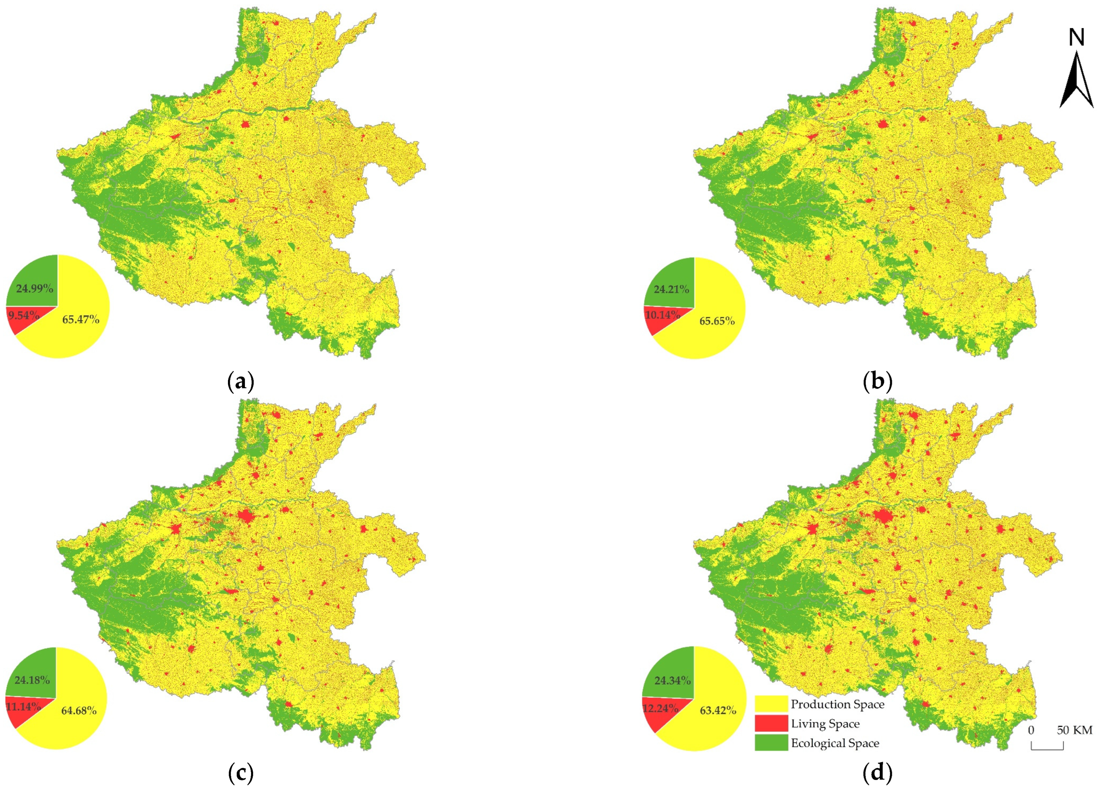
As illustrated in
Figure 3, the spatial distribution pattern of Henan Province’s PLES has remained relatively stable from 1990 to 2020, with distinct regional differences in the proportions of production, living, and ecological spaces. Production spaces dominate the Eastern and central regions, while living spaces, though scattered, are increasingly encroaching upon these areas. Ecological spaces are predominantly located in the Western and Southern regions. The pie chart in
Figure 3 reveals that production space consistently constituted the largest proportion of land use throughout this study period, followed by ecological space, with living space occupying the smallest proportion. Despite this, a notable shift in land use patterns is observed, particularly in the expansion of living spaces. From 1990 to 2020, the proportion of living space increased markedly from 9.54% to 12.24%, reflecting an accelerating trend: 0.6% during 1990–2000, 1% during 2000–2010, and 1.1% during 2010–2020. This growth suggests an intensifying demand for residential areas amidst ongoing urbanization. Conversely, ecological spaces experienced a reduction of 0.78% from 1990 to 2000, a marginal decline of 0.03% during 2000–2010, and a slight recovery of 0.16% between 2010 and 2020. This fluctuation indicates potential pressures on natural environments due to expanding human activities. Meanwhile, production space initially expanded slightly from 1990 to 2000 but then contracted significantly by nearly 1% during 2000–2010 and by 1.26% from 2010 to 2020, suggesting a shift in land use priorities possibly linked to policy changes or economic shifts. Overall, these trends underscore the dynamic nature of land use in Henan Province, with living spaces encroaching upon production and ecological spaces, reflecting broader socio-economic transformations over the three decades.
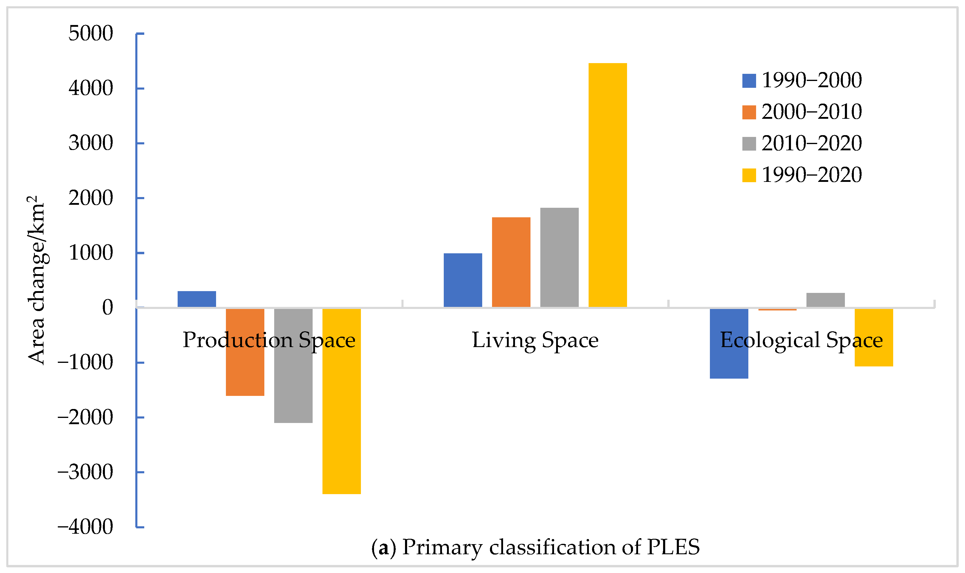
As illustrated in
Figure 4a, the period from 1990 to 2020 saw substantial shifts in the areas of PLES categories across Henan Province. The trends observed reveal a dynamic and complex evolution of land use, with significant changes in production, living, and ecological spaces.
Production Spaces: The area of production spaces followed an “increase–decrease–decrease” trajectory over the three decades. Initially, there was a modest increase of 302.92 km² between 1990 and 2000, likely driven by economic growth and industrial expansion. However, this was followed by a sharp decline, with reductions of 1600.83 km2 from 2000 to 2010 and 2096.71 km2 from 2010 to 2020. Overall, production spaces contracted by 3394.62 km2, representing a 3.13% decrease from 1990 levels. This reduction can be attributed to the shift from industrial production to urbanization, reflecting broader economic transformations in the region.
Living Spaces: In contrast, living spaces exhibited consistent growth, expanding by 4459.41 km2 over this study period, marking a significant 28.22% increase. This trend, particularly pronounced during the last decade (2010–2020), with an increase of 1822.59 km2, underscores the rapid urbanization and population growth in Henan Province. The expansion of urban and rural living areas highlights the increasing demand for residential land, driven by economic development and improved living standards.
Ecological Spaces: The area of ecological spaces followed a “decrease–decrease–increase” pattern. The most significant reduction occurred between 1990 and 2000, with a loss of 1289.26 km2, likely due to the encroachment of agricultural and urban land uses. A minor decrease of 45.16 km2 was observed from 2000 to 2010, followed by a slight recovery of 266.92 km² between 2010 and 2020. Despite this late-stage increase, ecological spaces overall decreased by 1067.43 km2, a 2.58% decline from 1990 levels, reflecting the ongoing pressures on natural habitats from expanding human activities.
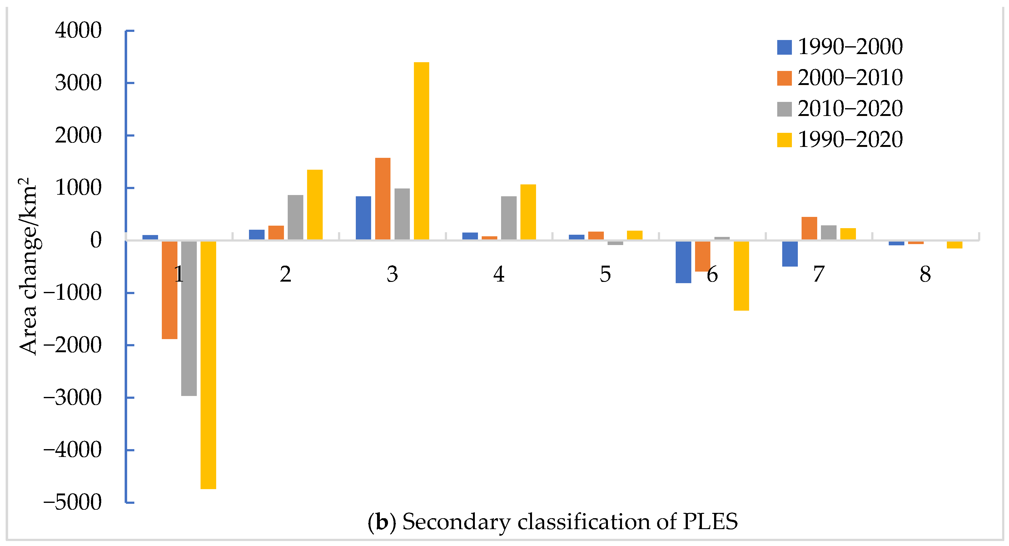
Secondary Classification Insights:
Figure 4b further dissects these changes, revealing that agricultural production land, grasslands, and other ecological lands faced significant reductions over the 30-year period. Agricultural land decreased by 4740.67 km
2, grasslands by 1338.19 km
2, and other ecological lands by 150.20 km
2. Conversely, there was a modest increase in forest lands (186.59 km
2) and water bodies (234.31 km
2), suggesting some efforts at ecological restoration or conservation. Simultaneously, areas designated for industrial production and urban and rural living experienced substantial growth, with increases of 1346.40 km
2, 3394.19 km
2, and 1065.22 km
2, respectively. This shift indicates a significant encroachment of urban and industrial activities into agricultural and ecological lands, driven by the demands of urban expansion and economic development.
The results highlight the profound impact of urbanization and industrialization on land use patterns in Henan Province. The expansion of urban and rural living spaces and industrial production areas at the expense of agricultural and ecological lands poses challenges for sustainable development. The ongoing reduction in ecological spaces, despite slight recent gains, raises concerns about the long-term environmental sustainability of the region. The data underscores the need for balanced land use planning that considers both economic development and environmental conservation.
3.2. Mutual Conversion Evolution Characteristics of PLES
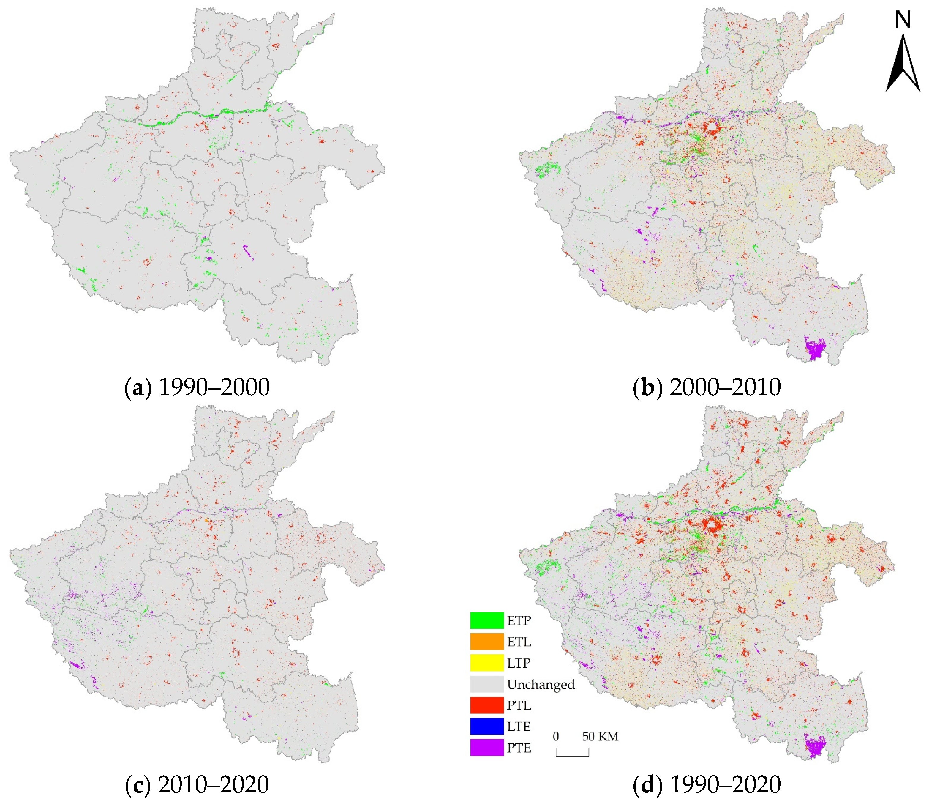
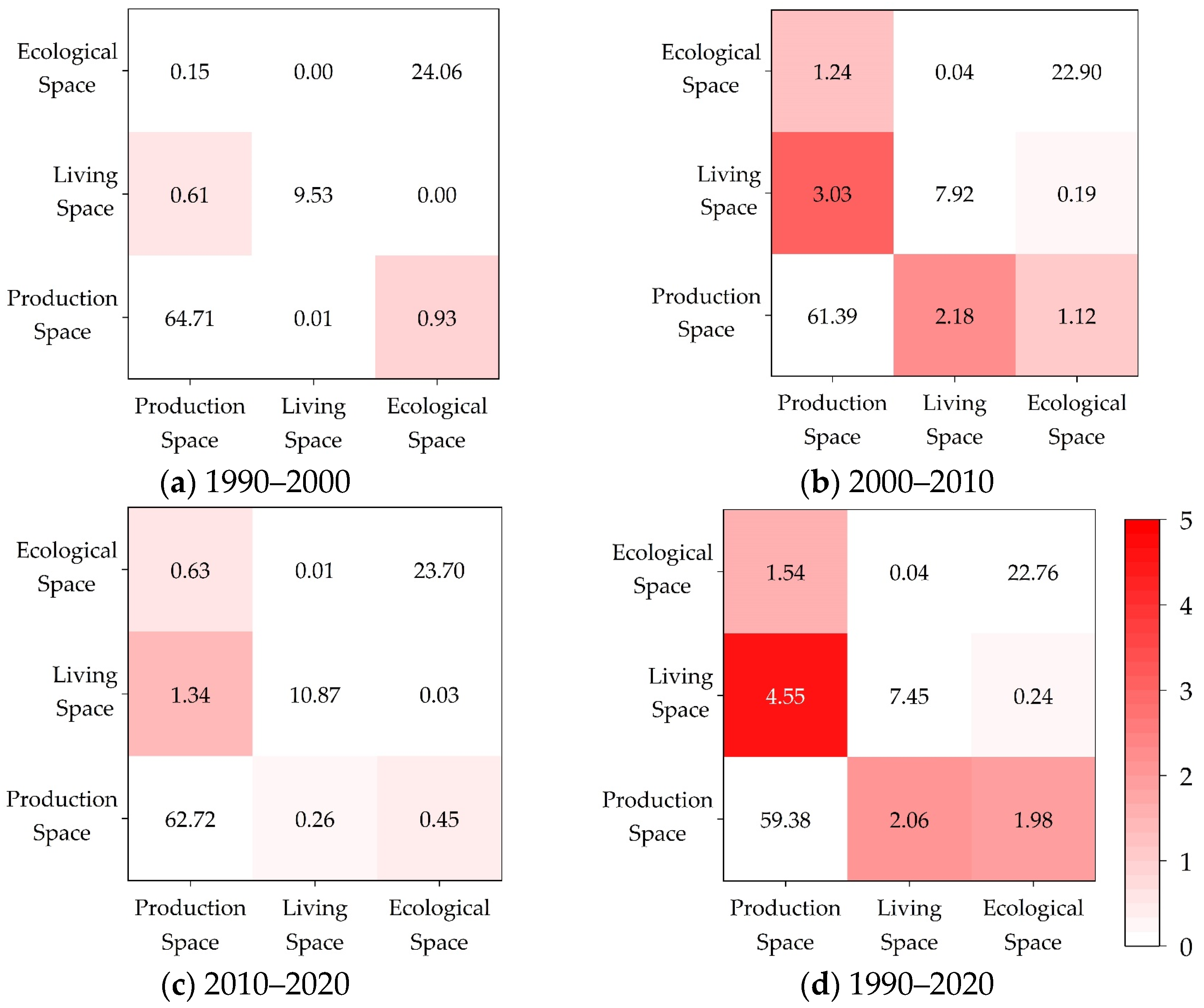
As depicted in
Figure 5 and
Figure 6, significant land use transitions occurred across Henan Province between 1990 and 2020, with distinct regional patterns emerging. The central-Eastern area of the province primarily experienced shifts between production and living spaces, reflecting the region’s rapid urbanization and industrial development. In contrast, the Western and Southern regions, along with the Yellow River basin, witnessed more pronounced conversions between production and ecological spaces, indicating ongoing pressures on natural habitats and the expansion of agricultural activities.
1990–2000: During this decade, the most notable transitions involved the conversion of ecological space to production space, particularly in the Yellow River basin and Southern regions of Henan Province. These transitions were concentrated at the junctions between Nanyang and Pingdingshan, Nanyang and Zhumadian, and within the cities of Nanyang and Xinyang. This period saw a 0.93% change in the total PLES area, reflecting the increasing demand for agricultural and industrial land driven by population growth and economic development. Additionally, there was a significant transition from production space to living space in various cities, accounting for a 0.61% change, highlighting the early stages of urban expansion in the province.
2000–2010: The decade from 2000 to 2010 was marked by more dynamic and widespread land use transitions. The most significant change was the shift from production space to living space, which accounted for a 3.03% change in the total area. This transition was particularly evident in Zhengzhou and nearby cities, where rapid urbanization led to the conversion of vast areas of agricultural land into residential and commercial spaces. Simultaneously, there were notable transitions from production space to ecological space (1.24%) and from living space (2.18%) and ecological space (1.12%) to production space, reflecting the ongoing competition for land between urban expansion and ecological conservation. The transitions from ecological space to production space were concentrated in Zhengzhou and its surrounding areas, as well as in the mountainous regions of Western Henan. The reverse transition, from production to ecological space, occurred primarily in the Yellow River basin and in the Southern cities of Nanyang and Xinyang.
2010–2020: The period from 2010 to 2020 continued to witness significant land use transitions, although at a slightly reduced scale compared to the previous decade. The transition from production space to living space remained noticeable, particularly in the cities of Henan, but accounted for a smaller proportion of the total area change (1.34%). This suggests a stabilization of urban expansion as the region approaches the limits of its available land resources. Exchanges between production (0.63%) and ecological (0.45%) spaces were concentrated in Southern Henan, indicating ongoing adjustments in land use to balance the needs of agricultural production with ecological preservation.
These land use transitions reveal a complex interplay between urbanization, industrialization, and ecological conservation across Henan Province. The central-Eastern regions, driven by economic growth, have seen a significant encroachment of living spaces into production areas, while the Western and Southern regions have faced pressures on ecological spaces due to agricultural expansion. The disparities in land use changes across different regions of Henan underscore the challenges of managing sustainable development in a rapidly urbanizing landscape. The ongoing transitions between production and ecological spaces, particularly in environmentally sensitive areas like the Yellow River basin, highlight the need for targeted land use policies that prioritize both economic development and environmental sustainability.
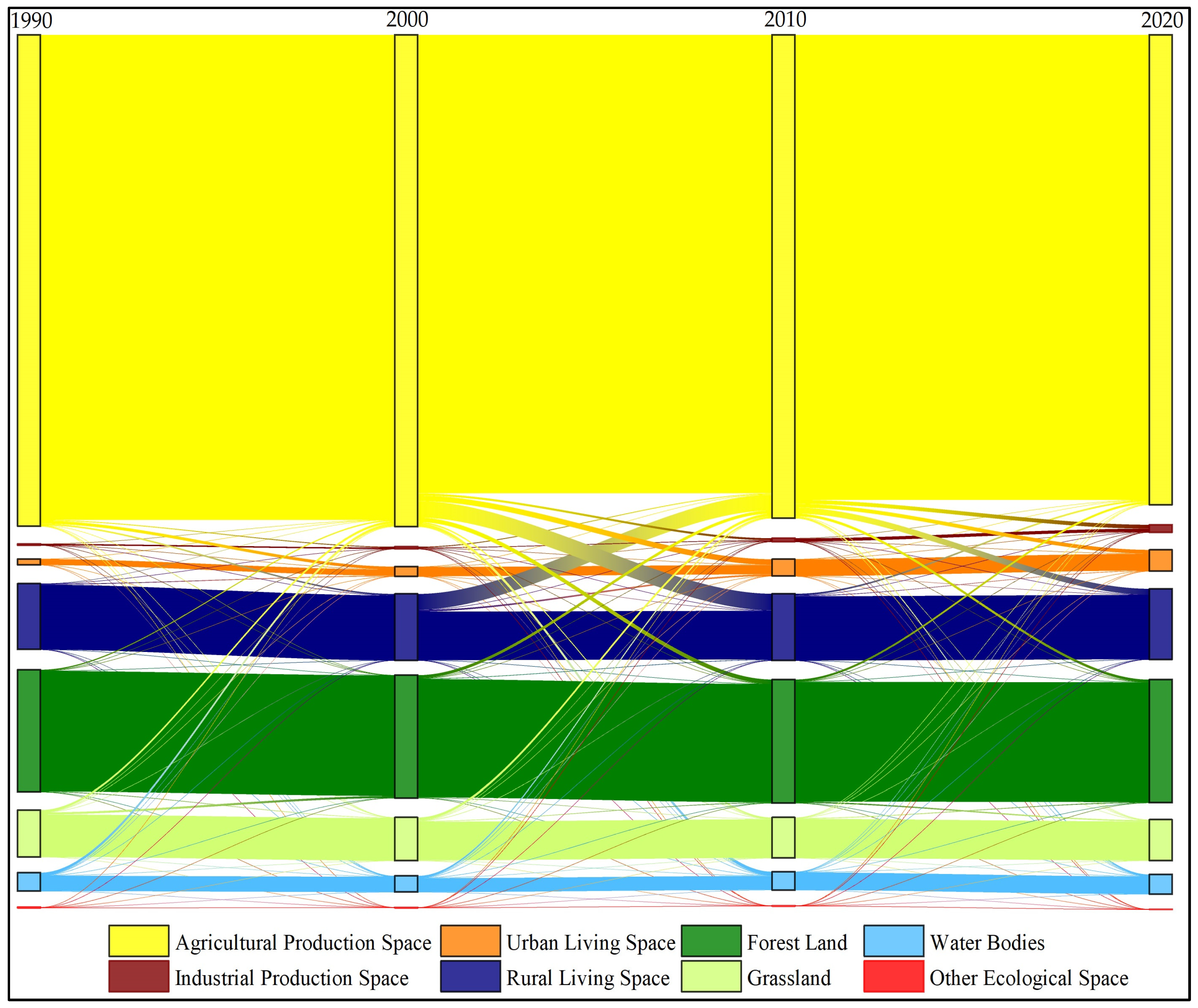
The analysis of land use changes through secondary classification, as depicted in
Figure 7 and detailed in
Table 3, reveals significant shifts in Henan Province’s landscape between 1990 and 2020. These transitions reflect the interplay between urbanization, agricultural expansion, and ecological conservation efforts, driven by regional development policies.
1990–2000: During this decade, the most prominent land use transitions were from ecological space to agricultural production space, particularly involving the conversion of water bodies (636.21 km2), grasslands (509.44 km2), and forest land (266.82 km2). These changes highlight the aggressive land reclamation practices and urbanization initiatives that encroached upon vital water resources from the Yellow River and natural habitats in hilly and mountainous areas. Concurrently, significant portions of agricultural production space were converted into urban (647.24 km2) and rural (342.88 km2) living areas, indicating the early stages of urban expansion at the expense of agricultural land.
2000–2010: The following decade witnessed a substantial acceleration in the conversion of production space to living space, driven by the rapid expansion of urban (1211.36 km2) and rural (1327.82 km2) areas into agricultural land. This period also saw pronounced exchanges between production and ecological spaces, as illustrated by the transition of agricultural production space into forest land (968.33 km2) and water bodies (743.90 km2). Simultaneously, forest land (677.90 km2), grasslands (592.13 km2), and water bodies (400.12 km2) were converted back into agricultural production space, reflecting the dual pressures of land reclamation and conservation efforts such as the “Grain for Green” initiative and measures to protect the Yellow River. Notably, the transition from rural living areas (3472.90 km2) back to agricultural production space underscores the impact of policies aimed at returning residents to agriculture, reversing some of the earlier urban expansion.
2010–2020: The decade from 2010 to 2020 continued the trend of transforming agricultural production space into urban (838.82 km2) and rural (1327.82 km2) living areas, further intensifying the shift from production space to living space. Additionally, 581.80 km2 of agricultural production space was converted into forest land and 336.73 km2 into water bodies, reflecting ongoing ecological restoration efforts. However, the concurrent conversion of 475.79 km2 of forest land back into agricultural production space indicates the persistent demand for agricultural land, driven by population growth and food security concerns.
Overall Trends (1990–2020): Over the entire study period, agricultural production space underwent significant transformations, primarily being converted into urban (2744.56 km2) and rural (4671.60 km2) living areas, as well as into forest land (1364.37 km2), industrial production space (1250.20 km2), and water bodies (812.64 km2). These changes reflect the broader trends of urbanization, industrialization, and ecological conservation in Henan Province. Simultaneously, substantial areas of forest land (1155.52 km2), grasslands (1079.29 km2), and water bodies (685.31 km2) were converted into agricultural production space, highlighting the ongoing tensions between land development and environmental protection.
The land use transitions observed from 1990 to 2020 underscore the complex dynamics of regional development in Henan Province. The aggressive expansion of living and industrial spaces at the expense of ecological and agricultural lands reflects the challenges of balancing economic growth with environmental sustainability. The data suggest that while efforts have been made to restore ecological spaces, the persistent conversion of natural lands into agricultural production spaces remains a significant issue. This ongoing transformation has profound implications for the region’s environmental health and the long-term viability of its natural resources.
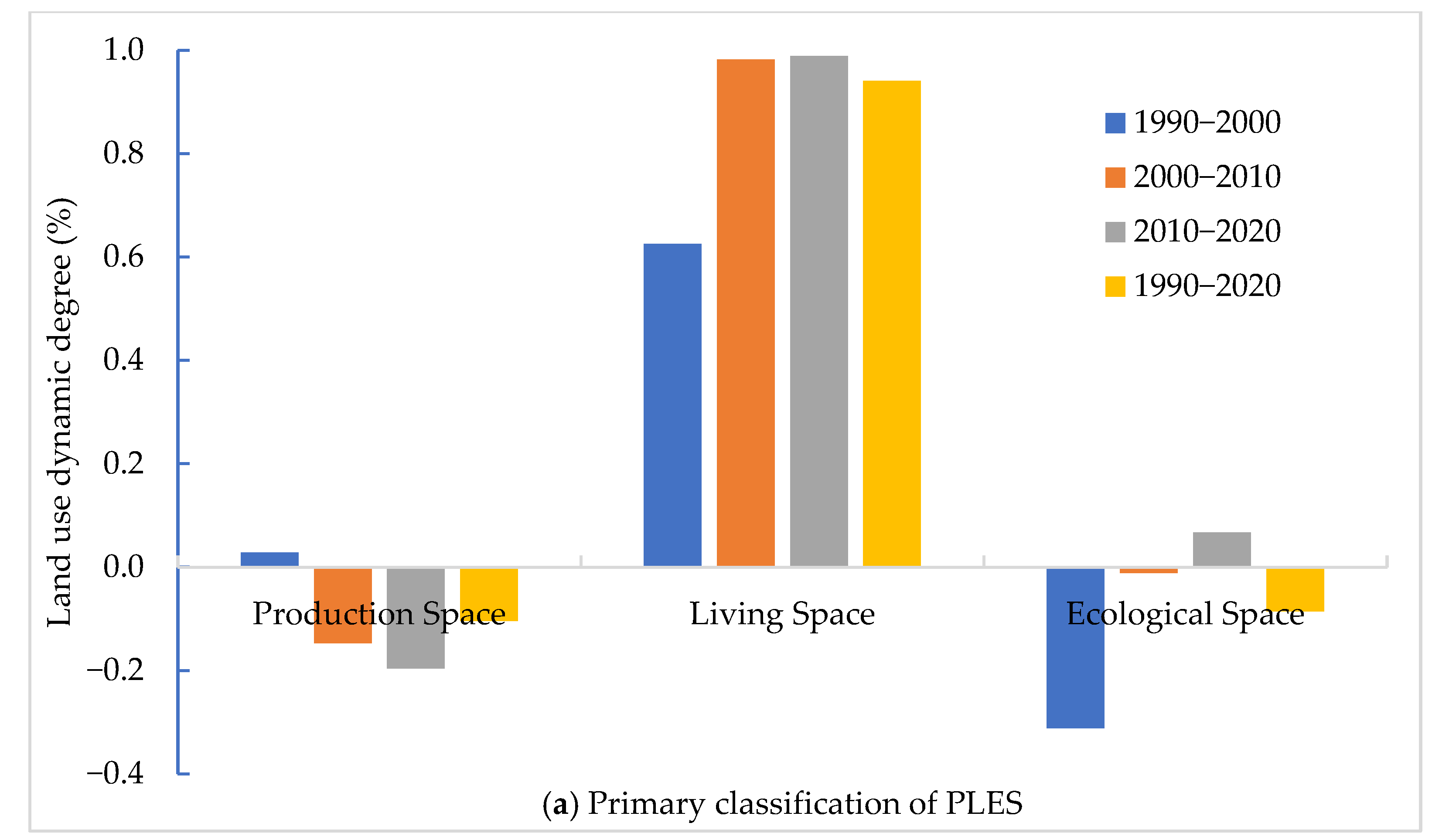
3.3. Evolutionary Characteristics of Land Use Dynamic Degree Within PLES
The land use dynamics of PLES primary classifications in Henan Province, as depicted in
Figure 8a, remained relatively low in intensity and speed over the 30-year period from 1990 to 2020. The trends observed in production space, living space, and ecological space reflect distinct patterns of change, each with different implications for regional development and environmental sustainability.
Production Space: Over the three decades, the dynamic degree for production space showed an “initial slight increase followed by a consistent decrease”, with overall dynamic rates of 0.03% (1990–2000), −0.15% (2000–2010), and −0.20% (2010–2020). This indicates that while there was a modest expansion in production space during the 1990s, the following decades saw a continuous and accelerating decline. The downward trend suggests a gradual shift away from agricultural and industrial production areas, likely due to urbanization pressures and changes in land use policies favoring residential and ecological spaces.
Living Space: In contrast, living space exhibited a “consistent increase” throughout this study period, with dynamic rates of 0.63% (1990–2000), 0.98% (2000–2010), and 0.99% (2010–2020). These consistently positive values indicate a steady and accelerating expansion of residential areas, reflecting the ongoing urbanization and population growth in Henan Province. The increasing intensity and speed of this growth highlight the challenges of managing urban sprawl and ensuring sustainable development in rapidly growing urban centers.
Ecological Space: The dynamics of ecological space showed a more complex pattern, described as a “decelerating decrease followed by a slight increase”. The dynamic rates for ecological space were −0.31% (1990–2000), −0.01% (2000–2010), and 0.07% (2010–2020). This trajectory reflects an initial period of rapid decline in ecological areas during the 1990s, likely due to land reclamation and urban expansion. However, the rate of decline slowed significantly in the 2000s, and by the 2010s, there was a modest recovery. This suggests that conservation efforts and policies such as reforestation and wetland protection may have started to take effect, contributing to the stabilization and slight increase of ecological spaces in the region.
The contrasting dynamics of production, living, and ecological spaces reveal the shifting priorities in land use in Henan Province over the past 30 years. The decline in production space, coupled with the rapid expansion of living spaces, underscores the impact of urbanization and economic development on traditional agricultural and industrial areas. Meanwhile, the initial loss and subsequent stabilization of ecological spaces highlight the ongoing tension between development and environmental conservation. These trends have significant implications for land use planning, indicating the need for balanced policies that support urban growth while preserving essential ecological areas and sustaining agricultural productivity.
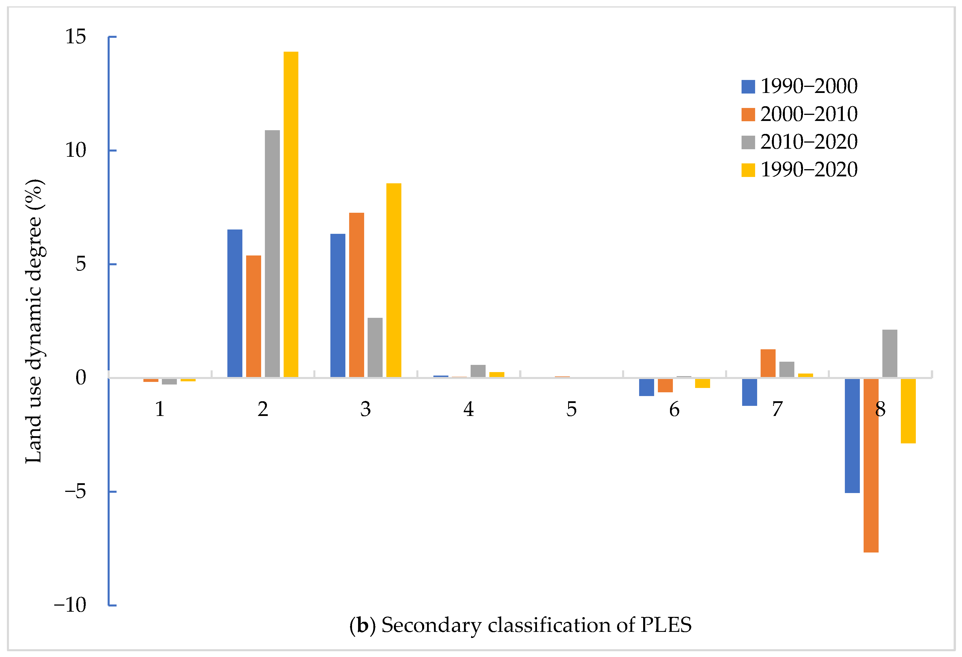
The analysis of secondary classifications from 1990 to 2020, as illustrated in
Figure 8b, reveals distinct patterns in the land use dynamics across Henan Province, driven largely by rapid urbanization and industrial development. Industrial production land experienced the most significant growth, with consistently positive land use dynamics throughout the 30-year period. The overall dynamic degree was 14.35%, reflecting the intense industrialization in the region. During the 1990–2000 and 2000–2010 periods, the dynamic degrees were relatively stable at 6.52% and 5.38%, respectively. However, the pace of industrial expansion accelerated dramatically during 2010–2020, with the dynamic degree rising to 10.88%. This trend underscores the region’s increasing focus on industrial development, driven by economic policies that prioritize manufacturing and infrastructure projects. Urban living areas also saw substantial growth, with an overall dynamic degree of 8.55%. The periods 1990–2000 and 2000–2010 showed robust growth with dynamic degrees of 6.34% and 7.26%, respectively. However, the rate of growth slowed considerably between 2010 and 2020, with the dynamic degree dropping to 2.64%. This deceleration may reflect the maturation of urban areas, where the pace of expansion slows as available land becomes more limited and urban planning becomes more focused on densification rather than outward growth. Among the land use types, other ecological lands were the only category to experience significant decreases over this study period, with dynamic degrees of −5.06% for 1990–2000 and −7.67% for 2000–2010. However, during 2010–2020, this trend reversed, and the dynamic degree turned positive at 2.12%, resulting in an overall dynamic degree of −2.87% for the 30-year period. This shift suggests a growing recognition of the importance of ecological conservation in the later years, possibly due to policy interventions aimed at reversing environmental degradation. Grasslands and water bodies exhibited relatively modest land use dynamics compared to other categories. Grasslands consistently declined between 1990 and 2010, with negative dynamic rates of −0.79% and −0.63%. Although there was a slight recovery between 2010 and 2020, with a dynamic rate of 0.07%, this growth was minimal, indicating that the intensity and speed of grassland restoration efforts were limited. Water bodies, on the other hand, had a negative dynamic degree of −1.22% during 1990–2000 but showed positive growth in subsequent decades, with dynamic degrees of 1.25% and 0.72% for 2000–2010 and 2010–2020, respectively. This improvement may reflect efforts to restore and protect water resources in the region. Despite substantial absolute transitions in agricultural production land and forests, their land use dynamics were not as pronounced as in other categories. The relative stability of these areas suggests that while there were significant land use changes, they did not occur with the same intensity or speed as the more rapidly changing industrial and urban areas.
The rapid expansion of industrial production land and urban living areas highlights the region’s economic growth, while the fluctuations in ecological land and the modest recovery of grasslands and water bodies suggest ongoing challenges in balancing development with environmental sustainability. The slowdown in urban living area growth and the positive shift in ecological land dynamics in the last decade indicate a potential shift towards more sustainable land use practices. However, the overall trends underscore the need for continued attention to land use planning and environmental management to ensure that economic development does not come at the expense of ecological health.
3.4. Driving Force Analysis
The changes in Henan Province’s ‘PLES’ dynamics are influenced by multiple factors. Existing research suggests that socio-economic and demographic factors are among the primary influences on these changes in Henan Province. Therefore, this study selected seven indicators: Gross Domestic Product (GDP) (X1), Secondary Sector GDP (X2), Tertiary Sector GDP (X3), Local Fiscal Revenue (X4), Local Fiscal Expenditure (X5), Year-end Total Population (X6), and Green Space in Built-Up Areas (X7) to explore the driving mechanisms behind the changes in Henan’s ‘PLES’ dynamics.
Initially, SPSS 29 was employed to normalize all variables. The linearity between each independent variable and the dependent variable was then verified. Results indicated significant correlations between each independent variable and the dependent variable, with all R-values exceeding 0.6 and all p-values equal to 0.01, making them suitable for multiple linear regression analysis. A multicollinearity test was performed on all independent variables, revealing that the variance inflation factor (VIF) for all exceeded 10, suggesting significant multicollinearity among the variables. Therefore, PCA was employed to eliminate multicollinearity among independent variables. The Kaiser–Meyer–Olkin (KMO) measure and Bartlett’s test of sphericity were applied, showing a KMO value of 0.710 and a significance p-value of 0.000, meeting the criteria for PCA (a required KMO value > 0.5 and significance p-value < 0.05). Therefore, PCA was utilized on the standardized influencing factors. The results were deduced by combining eigenvalues and the component matrix.
Using PCA, a primary component
Z was extracted, as shown in Formula (4). This component represents the key socio-economic factors influencing the changes in Henan Province’s PLES dynamics. These socio-economic factors were then incorporated into a linear regression model, where the dependent variable Y represents the changed areas of PLES. The resulting regression equation is provided in Formula (5). Finally, by substituting the original independent variables
X back into the model, the relationship between the PLES dynamic changes
Y and each of the socio-economic variables
X is presented in Formula (6) [
45].
From the results of the regression analysis, it can be observed that the coefficients of all seven variables are positive. This indicates that all seven variables have a positive influence on the changes in the PLES dynamics of Henan Province. The degree of impact in decreasing order is as follows: Tertiary Sector GDP > GDP > Local Fiscal Revenue > Secondary Sector GDP > Green Space in Built-Up Areas > Local Fiscal Expenditure > Year-end Total Population. These seven variables can be roughly categorized into 4 groups: socio-economic factors (GDP, Local Fiscal Revenue, Local Fiscal Expenditure), demographic factors (Year-end Total Population), industrial structure factors (Secondary Sector GDP, Tertiary Sector GDP), and ecological factors (Green Space in Built-Up Areas). Each of these factors is explored in relation to their impact on the changes in the PLES dynamics of Henan Province.
Socio-economic Factors. These factors are one of the key driving forces behind the PLES dynamic evolutions. Local fiscal revenue and expenditure as well as the GDP are crucial indicators at the economic level. GDP measures the overall economic development of a region. A high GDP indicates rapid urban development. Meanwhile, local fiscal revenue and expenditure are key indicators that influence urban infrastructure construction, like roads, and are integral to the city’s development. The rapid economic growth has a significant impact on the changes in Henan’s PLES dynamics. Firstly, agricultural production provides a foundation and security for economic development, and industrial production powers the economy. Economic development is inseparable from the expansion of productive space and the enhancement of production efficiency. Secondly, rapid economic growth influences the distribution pattern of the PLES dynamics and can accelerate changes in urban spatial structures, especially with investments and development in industries like real estate, which expand the scope of living spaces. At the same time, the rapid economic growth has accelerated the urbanization process in Henan Province, facilitating the land use structure evolutions and the transformation of the PLES dynamics.
Population Factors. Henan Province has a large population. As of 2020, the permanent resident population of Henan Province reached 99.366 million, representing 7.04% of the total population of China, ranking third in the country. Moreover, Henan’s population growth rate is rapid. Compared to the sixth national census in 2010, the population increased by 5.342 million, an increase of 5.68%, with a yearly increase rate of 0.55% on average. Within the land use system, humans are organizers, participants, and users of the system’s output products. They are the direct constructors and participants of the PLES dynamics. On the one hand, population growth inevitably increases the demand for living space, including the demand for housing and public infrastructure such as supermarkets, hospitals, parks, and roads, which in turn promotes the rapid expansion of living spaces. On the other hand, an increase in population results in a surge in demand for agricultural and sideline products, which subsequently affect changes in the production space and enhance production efficiency.
Industrial Structure Factors. Changes in the spatial dynamics of PLES are influenced by the evolution and refinement of industrial structures. Distinct industries exhibit varied requirements for land regarding its distribution, volume, and quality. Consequently, as industries evolve and restructure, there necessitates a parallel realignment in PLES distribution. Concurrently, the enhancement and progression of industrial frameworks propel economic growth, which in turn impacts the interconversion of PLES types. Additionally, the accelerated growth in secondary and tertiary sectors creates numerous job opportunities, attracts population influx, and consequently amplifies the need for spaces dedicated to production and living.
Ecological Factors. Due to urbanization, human damage to nature is becoming increasingly severe. Coupled with the continuously rising demands for a better living environment and quality of life, higher standards are set for urban construction. Urban greening areas, as one of the essential indicators for measuring the quality of the urban living environment, have been increasingly receiving attention and importance from urban residents in recent years. Concepts such as the “Garden City” more clearly express the direction of harmonious coexistence between humans and nature and people’s keen expectations for “urban greening”. Ecological factors are profoundly affecting people’s production and living methods from concept to practice, from ideas to realization. Increasing the green area in built-up areas is one of the essential measures to enhance urban living comfort and improve urban ecological functions. Ecological environment protection is the foundational condition affecting the changes in PLES. A good ecological environment is the basis for development and is the prerequisite for promoting green production and green living. In the planning pattern of the distribution of PLES in Henan Province, the concept of “ecological civilization” should always be implemented, emphasizing coordinating the relationships among “ecology,” “living,” and “production” to ensure the relative balance of PLES and guarantee the balanced changes of PLES in Henan Province.
4. Findings and Discussion
Regions undergoing rapid economic expansion often face a delicate balancing act between maintaining agricultural production, accommodating the needs of growing urban populations, and preserving ecological spaces. The shifts between these spaces mirror broader global patterns of resource competition, as the demands of economic growth drive urbanization while creating pressures on finite land and environmental resources. The intricate interaction between production, living, and ecological spaces highlights a universal challenge that underscores the need for strategic regional planning. This study delves into these dynamics, illustrating the critical importance of an integrated approach to managing land use that aligns economic priorities with environmental conservation.
4.1. Global Implications of Findings
In the context of Henan Province, a major grain-producing region in China, the transformation marked by the continuous decrease in agricultural space and the increase in living space is especially critical, given Henan’s key role in ensuring national food security. Henan’s agricultural land, primarily used for grain production, has faced increasing pressure from urban expansion driven by rapid industrialization and population growth. As a result, production spaces have been converted into living and industrial spaces, reducing the land available for agriculture. This reduction has significant implications for China’s food security policies, especially as Henan is a vital part of the nation’s grain production strategy. From a social perspective, the migration of rural populations to urban centers in search of better economic opportunities has contributed to the decline in agricultural labor. The urbanization drive, coupled with policies promoting urban development, has altered land use priorities. Younger generations, attracted by jobs in the manufacturing and service sectors, have increasingly abandoned farming, reducing the workforce available for agriculture and accelerating the conversion of agricultural land. Politically, China’s central government has implemented various policies to balance urban development and agricultural preservation, but tensions remain. The National Land Use Planning Outline and the Basic Farmland Protection Policy are key government measures aimed at safeguarding agricultural land. However, local governments in regions like Henan, driven by the need for economic growth, often prioritize urban and industrial development over agricultural preservation. This results in competing priorities between agricultural preservation and local economic interests. Moreover, fiscal policies provide incentives for local governments to promote land conversion for non-agricultural purposes. The revenue generated from land development, particularly for urban expansion, plays an important role in supporting local budgets. This creates a political and economic dynamic where urban growth becomes financially beneficial for local authorities, even though it sometimes comes at the expense of agricultural production land. These political and social dynamics underscore the complexity of land use transformations in Henan. The region’s role in ensuring national food security means that its agricultural land is of strategic importance. However, the pressures of urbanization, migration, and economic policies challenge the preservation of these production spaces. Effective management of these competing priorities requires coordinated policy interventions that not only promote sustainable urban growth but also protect critical agricultural resources.
The transformation of production spaces, traditionally dominated by agriculture, is emblematic of a global trend where urbanization disrupts traditional economic foundations, particularly in rural areas. This phenomenon, where the rapid expansion of urban areas leads to the reallocation of land previously used for agriculture, is not confined to any one country but represents a global shift. Many developing nations, especially those experiencing a population boom, find themselves reallocating agricultural land for residential, industrial, and commercial use, resulting in strain on food security, local economies, and the environment. A notable case study is India, where rapid urbanization in cities like Delhi and Mumbai has resulted in significant land use transformations [
46,
47]. Agricultural lands on the outskirts of these cities have been increasingly converted to urban residential and industrial spaces, similar to the trends observed in Henan. This has led to significant challenges in managing food security as shrinking agricultural spaces struggle to meet the needs of growing urban populations. In response, India has initiated sustainable land use policies such as the National Mission for Sustainable Agriculture (NMSA), aiming to balance agricultural preservation with urban development.
In Brazil, particularly around São Paulo [
48], the expansion of industrial zones has mirrored the findings in Henan, where production spaces for agriculture have been overtaken by industrial activities. The Brazilian government has introduced policies like the National Green Growth program designed to protect ecological and agricultural areas from urban sprawl. Similar to the ecological recovery efforts observed in Henan during 2010–2020, Brazil has focused on reforestation and the protection of its rich biodiversity, particularly in the Amazon region. In Africa, countries like Nigeria (Lagos) and Kenya (Nairobi) also face rapid urbanization that threatens ecological and agricultural spaces [
49,
50]. Like Henan, these regions are experiencing significant land use transitions, where agricultural and ecological lands are being converted into urban and industrial spaces. In response, both Nigeria and Kenya have adopted integrated land use plans similar to China’s PLES framework to mitigate these impacts. In Nigeria, the Lagos State Government has emphasized the development of eco-industrial parks to curb the negative effects of industrialization on natural habitats.
These examples demonstrate that the challenges Henan faces are not unique but are part of a broader, global trend of urbanization. As urban areas continue to expand, the demand for residential and industrial space grows, often at the expense of agricultural and ecological lands. The global relevance of the PLES framework lies in its capacity to guide land use strategies that balance economic growth with environmental conservation. By examining the trends in Henan and drawing from international examples, this study provides critical insights for regions worldwide. The implementation of adaptive land use strategies, as demonstrated in Henan, offers a pathway for sustainable urbanization that can be applied across various contexts globally.
4.2. Environmental Challenges and Sustainable Development
The environmental challenges posed by land use changes, particularly the expansion of urban and industrial areas at the expense of ecological lands, highlight a global issue: the struggle to balance economic growth with ecological sustainability [
51,
52]. These changes are exacerbated by increasing populations and industrialization, both of which place heavy demands on natural ecosystems. Urban sprawl often leads to habitat loss, reduced biodiversity, and the degradation of vital ecosystem services such as air and water purification, flood control, and carbon sequestration. Moreover, the intensification of land use frequently results in fragmented ecological spaces, disrupting wildlife corridors, and diminishing the ecological resilience of entire regions. As environmental pressures mount globally, the findings of this study emphasize the need for comprehensive land use policies that promote compact, resource-efficient urbanization. Regions can mitigate environmental harm by adopting smart growth policies that integrate green infrastructure, protect critical natural areas, and enhance the ecological functionality of urban spaces.
4.3. Contribution to Global Policy and Practice
The development trajectory identified in this study provides significant implications for global policy and practice, particularly in the context of the Sustainable Development Goals (SDGs) [
53,
54]. The transformation of PLES aligns directly with several key SDGs, emphasizing the necessity of sustainable urban planning that considers long-term environmental and social impacts [
55,
56]. This study’s findings suggest that achieving SDG targets such as sustainable cities (SDG 11), responsible consumption (SDG 12), and Life on Land (SDG 15) requires a more holistic view of land use, integrating socio-economic and ecological dimensions. As cities expand, land consumption should be minimized by encouraging vertical growth and optimizing existing urban spaces. In parallel, efforts must focus on enhancing public green spaces, preserving biodiversity, and supporting climate resilience through adaptive land management practices. The global applicability of these strategies lies in their capacity to be tailored to the specific economic, social, and environmental contexts of regions around the world, reinforcing the universal nature of the SDGs.
4.4. Towards a Balanced Approach in Regional Development
The results exemplify the broader global challenge of balancing economic growth with ecological preservation, especially during periods of rapid urbanization. This challenge is particularly pressing in regions where economic growth is seen as the primary means of improving living standards. Yet, the prioritization of short-term economic gains at the expense of environmental integrity leads to long-term consequences that are far more difficult—and costly—to reverse [
52]. Ecosystem degradation, loss of biodiversity, and the reduction of essential ecosystem services all contribute to a decline in quality of life and increase vulnerability to climate change impacts. This study reinforces the need for regional development strategies that do not merely accommodate growth but actively seek to sustain the ecological health of urban and rural areas. Planners must balance the immediate needs of expanding populations with the long-term imperative to conserve natural resources, ensuring that development today does not come at the cost of future generations’ ability to thrive.
4.5. Policy Recommendations and Global Relevance
The findings from Henan’s PLES evolution provide valuable insights that can inform sustainable development strategies for similar rapidly urbanizing regions globally, particularly in Asia, Africa, and Latin America, as well as developed regions in Europe, North America, and Australia. These strategies must prioritize integrated land use planning, balancing the expansion of urban and industrial areas with the protection of agricultural and ecological spaces [
57,
58]. For instance, in Asia (such as India’s Delhi and Bangladesh’s Dhaka), Africa (such as Nigeria’s Lagos and Kenya’s Nairobi), and Latin America (such as Brazil’s São Paulo and Mexico’s Mexico City), spatial zoning can be used to clearly define production, living, and ecological spaces, preventing urban sprawl from encroaching on vital agricultural lands that ensure food security. In these rapidly industrializing regions, the establishment of eco-industrial parks and the adoption of cleaner production technologies can minimize environmental degradation while sustaining economic growth. In developed regions such as Germany’s Hamburg, the United States’ Atlanta, and Australia’s Perth, these eco-industrial parks can help manage the environmental impacts of ongoing industrial activities. Additionally, the restoration and conservation of ecological spaces, through reforestation programs and conservation incentives like payments for ecosystem services, are critical for preserving biodiversity and mitigating climate change impacts in regions like Brazil’s Amazon basin and Australia’s arid regions. In Europe and North America (e.g., the UK’s London, the US’s Los Angeles, and Canada’s Toronto), real-time monitoring systems using high-resolution satellite data, as demonstrated in Henan, allow for continuous tracking of land use changes, enabling dynamic policy adjustments that respond to emerging pressures on land resources. Furthermore, engaging local communities in land use planning ensures that these strategies are socially and culturally appropriate, particularly in regions where land holds significant cultural value, such as in African and Latin American indigenous communities. By applying these adaptive strategies globally, from developing regions in Asia, Africa, and Latin America to developed regions in Europe, North America, and Australia, countries can align their land use policies with the United Nations Sustainable Development Goals (SDGs), particularly SDG 11 (Sustainable Cities and Communities), SDG 12 (Responsible Consumption and Production), and SDG 15 (Life on Land), ensuring that economic development proceeds without compromising ecological sustainability [
59].
4.6. Addressing Limitations and Future Directions
While this study provides significant insights, several limitations must be acknowledged. The data span from 1990 to 2020, which may not fully capture recent trends or the effects of newer policies aimed at sustainable urbanization [
60]. Although the focus on a particular region offers valuable insights, the findings might be less generalizable to regions with different socio-economic or environmental contexts. Furthermore, the reliance on land use change as a proxy for broader socio-economic and environmental transformations may overlook other critical factors such as technological advancements or shifts in policy. Future research could expand on this study by incorporating more recent data and applying similar methodologies to other regions, both within China and internationally, to identify broader patterns. Integrating qualitative data, such as stakeholder interviews or policy analysis, could also provide a richer understanding of the socio-political drivers behind land use changes. Additionally, exploring the long-term impacts of these trends on public health, biodiversity, and economic resilience would contribute to the development of more robust and sustainable policy frameworks. Further analysis focusing on the spatial correlations of land use evolution within different regions of Henan Province would also enhance the understanding of regional dynamics. By examining the spatial-temporal evolution and dynamic changes in surrounding areas affected by rapid urbanization, it becomes possible to identify intrinsic drivers that shape the transformation of PLES. Such insights would contribute to a more nuanced framework for sustainable land management, offering valuable implications for land use strategies under varying socio-economic and environmental conditions. Our prospective studies will focus on addressing these limitations along with undertaking robust correlation analysis of land use evolution across different regions.
5. Conclusions
The rapid pace of urbanization and population growth in many regions worldwide has led to profound shifts in land use patterns, with increasing demand for living space encroaching on agricultural and ecological lands. This study provides a detailed analysis of the spatiotemporal evolution of Production–Living–Ecological Spaces (PLES) in Henan Province, China, from 1990 to 2020. The findings reveal significant changes in land use, primarily driven by economic growth, urban expansion, and fiscal policies.
This study’s results demonstrate a notable reduction in production spaces, particularly in agricultural areas, alongside the expansion of living spaces in both urban and rural settings. Ecological spaces exhibit fluctuating trends, with periods of sharp decline followed by modest recovery. The mutual transitions between different land use types—especially between production and living spaces and between production and ecological spaces—highlight the complex trade-offs between development and environmental conservation. Socioeconomic factors, particularly growth in the tertiary sector, local fiscal revenue, and population increases, emerge as the key drivers behind these changes. This underscores the critical need for integrating economic and environmental policies to promote sustainable land use and regional development.
The findings carry significant global implications for achieving the Sustainable Development Goals (SDGs), particularly in regions experiencing rapid urbanization, where balancing economic growth with environmental sustainability is essential. The observed shifts in land use emphasize the need for integrated planning that prioritizes ecological preservation alongside economic development, thus contributing to the SDGs. Policymakers are encouraged to adopt sustainable economic policies, strengthen environmental protections, and ensure continuous monitoring and adaptive management to address the dynamic impacts of urbanization. International collaboration and knowledge exchange will be crucial in developing adaptable best practices across diverse regional contexts.
Nevertheless, this study has certain limitations, such as its reliance on remote sensing data, which may not capture all nuances of land use dynamics, and potential oversimplification of socio-economic factors. Future research should incorporate more comprehensive data sources and examine the long-term impacts of land use changes on public health, biodiversity, and economic resilience. Understanding the evolution of PLES provides critical insights for land use planning and can guide broader strategies to balance economic growth with environmental sustainability. This study establishes a solid framework for future research and policymaking, stressing the need for integrated approaches to managing land resources in rapidly urbanizing regions globally.
In conclusion, this study highlights the importance of analyzing the evolution of PLES to guide sustainable land use and regional planning. Through examining a 30-year transformation in Henan Province, the findings reveal critical trends, such as a significant shift from production to living spaces and complex interactions with ecological spaces. These patterns underscore the urgent need for sustainable policies that balance urban expansion with ecological preservation, especially in rapidly urbanizing regions. The insights gained from this study contribute to achieving SDGs by providing actionable strategies adaptable across diverse regional contexts. Future research should conduct robust correlation analyses across various regions to better understand the drivers behind land use changes and to support policy frameworks that promote resilience and ecological sustainability in the face of urban growth.


