1. Introduction
In the context of globalization, the escalating issues of climate change and environmental degradation have driven the international community toward a consensus on the importance of a low-carbon economy and sustainable development. People have begun to reassess traditional, high-carbon transportation modes and are shifting towards more environmentally friendly alternatives [
1].Slow-moving systems, such as walking and cycling, offer low-carbon alternatives to urban transportation systems, particularly for short-distance travel. The design and management of these systems must consider safety, convenience, comfort, and environmental sustainability to promote healthy lifestyles, improve urban living quality, and reduce transportation-related carbon emissions.
Higher education campuses face numerous challenges in managing slow-moving systems due to their unique spatial layouts and high staff densities. Meng Dan [
2] noted that as campus size expands and student numbers increase, the original walking and cycling paths often fail to meet the growing demand, leading to frequent human–vehicle conflicts. Luo Bingjun [
3] argued that the increase in private cars has also exacerbated traffic congestion and environmental pollution on campus. Cao Yuwen [
4] observed that certain areas of the campus lack adequate slow-moving infrastructure, such as dedicated bicycle lanes and pedestrian paths. This deficiency not only affects the walking and cycling experience of students and faculty but also raises the risk of pedestrian injuries and fatalities.
The importance of safety in university campus slow-moving systems cannot be overstated. Elżbieta Macioszek [
5] noted that the risk of pedestrian fatalities in traffic accidents is influenced by various factors, including driver behavior, vehicle type, and the accident environment. These factors highlight the need to prioritize pedestrian safety in designing slow-moving systems, particularly on campuses where design and management deficiencies can further elevate risks.
In this context, optimizing slow-moving systems on college campuses is both necessary and important. Qin Xi [
6] argues that enhancing the slow-moving transportation environment can effectively reduce motor vehicle use and carbon emissions, aligning with global low-carbon development trends. Yang Yannan [
7] suggests that optimizing the slow-moving system improves transportation efficiency and safety on campus, enhancing the travel experience for teachers and students. Yang Ding-hai [
8] contends that optimizing the slow-moving system fosters green travel habits among teachers and students, promoting a healthier lifestyle.
Regarding research methodology and case studies, Yin Yishu [
9] analyzed the current state of slow-moving traffic at the Ripu Campus of Southwest Jiaotong University and assessed the impact of shared bicycles using the PLPS survey and statistical analysis methods, proposing optimization strategies. Qin Xi [
6] developed a slow-moving system planning strategy based on green transportation concepts, considering factors such as neighborhood scale, slow-moving networks, public transportation connectivity, and facility landscape design. Chen Lu [
10] used the Fengqiu Education Park as a case study to propose slow-moving system planning strategies based on green transportation concepts, focusing on planning strategies at the point, line, and surface levels.
Zhang Xu Hao [
11] approached transportation planning and design on university campuses from a “people-oriented” sustainable development perspective, proposing methods based on green transportation concepts. Zhou Yuan [
12] applied the “people-oriented” concept in designing a slow-moving system for the Handan Campus of Fudan University, proposing a slow-moving system planning strategy. The case study of Fudan University’s Handan Campus demonstrates an overall traffic organization scheme based on slow-moving priority zones, addressing the differentiated traffic demands within the campus.
Andrea Scagni’s [
13] data-driven approach offers new insights into optimizing transportation systems on Italian university campuses, promoting a shift from automobiles to more sustainable transportation modes. Giulio Mario Cappelletti [
14] employs the Life Cycle Assessment (LCA) methodology by calculating Sustainable Mobility Indicators (SMIs) to optimize campus transportation systems, providing an assessment and benchmarking tool to help campus administrators better understand and improve the environmental performance of their systems.Stephen M. Posner [
15] proposed a systems thinking framework that identifies and leverages interactions both within and between campuses, as well as their relationships with environmental and social contexts, to evaluate and optimize campus sustainability efforts, thereby promoting a sustainable campus transportation system. Haoxuan Li [
16] analyzed the relationship between student behaviors and energy and carbon consumption levels, offering a new perspective on campus carbon reduction.
This paper aims to identify and address the shortcomings of the existing slow-moving system regarding safety, convenience, and comfort through an in-depth analysis of the slow-moving system on the Huangjiahu Campus of Wuhan University of Science and Technology (WUST), followed by a series of proposed optimization strategies. The article first introduces the concept of the slow-moving system and its importance in campus transportation, emphasizing its role in promoting a healthy lifestyle and reducing transportation-related carbon emissions. This paper then provides a detailed analysis of the current situation of the slow-moving system on the Huangjiahu Campus of Wuhan University of Science and Technology, including road usage, spatial quality, and overall satisfaction. A substantial amount of data were collected through field research and questionnaires, providing a robust foundation for subsequent analysis and optimization. Based on the analysis of the current situation, the article applies IPA to evaluate user satisfaction with the slow-moving system and identifies key areas for improvement. Finally, a series of targeted optimization strategies are proposed, including adjustments to road scale, improvements in traffic signage and lighting facilities, the expansion of the slow-moving network, the optimization of public transport connections, and enhancements to environmental design and accessibility facilities. These strategies aim to enhance the efficiency of campus transportation, improve environmental quality, and increase the vitality and attractiveness of campus space, while addressing the global trend in low-carbon development [
17].
2. An Overview of the Campus Slow-Moving System
The campus slow-moving system is a non-motorized transportation system designed to enhance walking and bicycling on university campuses, aiming to create a safe, comfortable, and continuous environment that promotes students’ physical health, socialization, and campus culture. As a key component of the campus transportation system, the slow-moving system significantly impacts the daily travel of students and faculty, as well as the environment and overall quality of campus life. In the design, three dimensions—safety, convenience, and comfort—must be considered.
Safety is the fundamental element in the design of the campus slow-moving system. Proper road dimensions, clear planning, and comprehensive transportation facilities form the foundation of safety. The design of spacious sidewalks and bicycle lanes ensures that pedestrians and cyclists have adequate space, thereby effectively reducing the risk of traffic congestion and potential conflicts. Campus roads should be designed to separate pedestrians from vehicles, minimize the number of intersections, reduce the likelihood of traffic accidents, and accommodate the needs of emergency vehicles. Additionally, clear road hierarchies can enhance traffic efficiency and safety in key areas. Clear traffic signs and adequate nighttime lighting improve the legibility of the slow-moving system and ensure necessary safety for pedestrians, particularly at night and during adverse weather conditions.
Convenience is a critical indicator of the effectiveness of a slow-moving system. An efficient slow-moving system should feature strong road connectivity, linking all buildings and facilities through direct and clear paths, reducing detours and waiting times. Comprehensive coverage of the slow-moving network, including main roads and secondary routes, offers a variety of options for different travel needs. To further enhance convenience, the slow-moving system should be seamlessly integrated with the public transportation systems both within and outside the campus, offering convenient transfer facilities, such as bicycle parking and bus stops, to facilitate smooth transitions between different modes of transportation for students and faculty.
Comfort is a crucial consideration in designing the campus slow-moving system. Well-designed greening, landscaping, and art installations not only enhance the visual appeal of the environment but also create a pleasant walking and cycling experience. Comprehensive facilities, such as bicycle parking spots, rest areas, and water points, meet users’ needs for rest and replenishment while moving slowly. Additionally, the campus slow-moving system should incorporate barrier-free designs, such as ramps and tactile paths, ensuring that all users can access the system conveniently and safely.
Considering safety, convenience, and comfort, the campus slow-moving system provides a safe, convenient, and comfortable travel environment for students and faculty, significantly enhancing the overall quality of campus life.
3. An Analysis of the Current Situation of the Slow-Walking System in Huangjiahu Campus
3.1. Research Objects
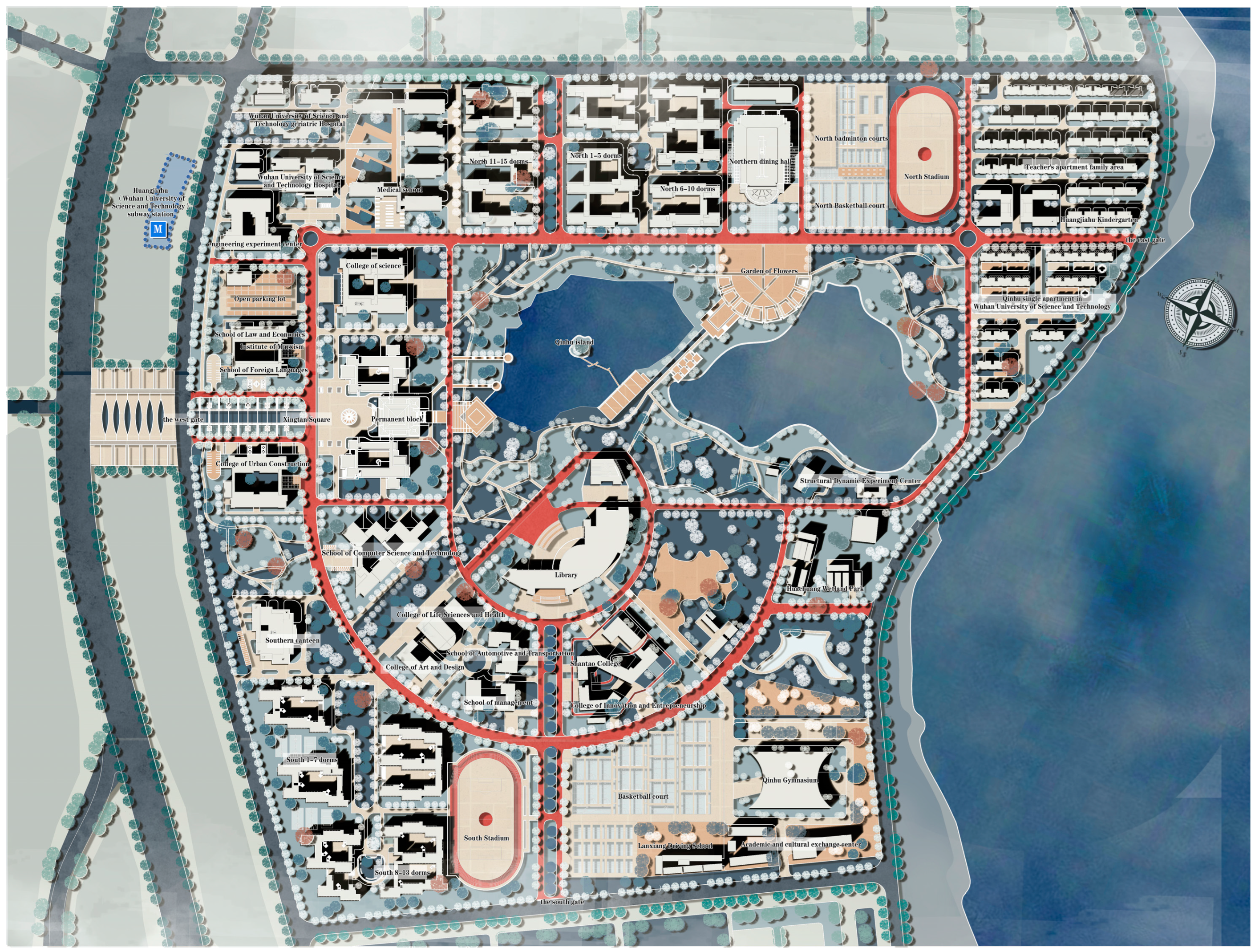
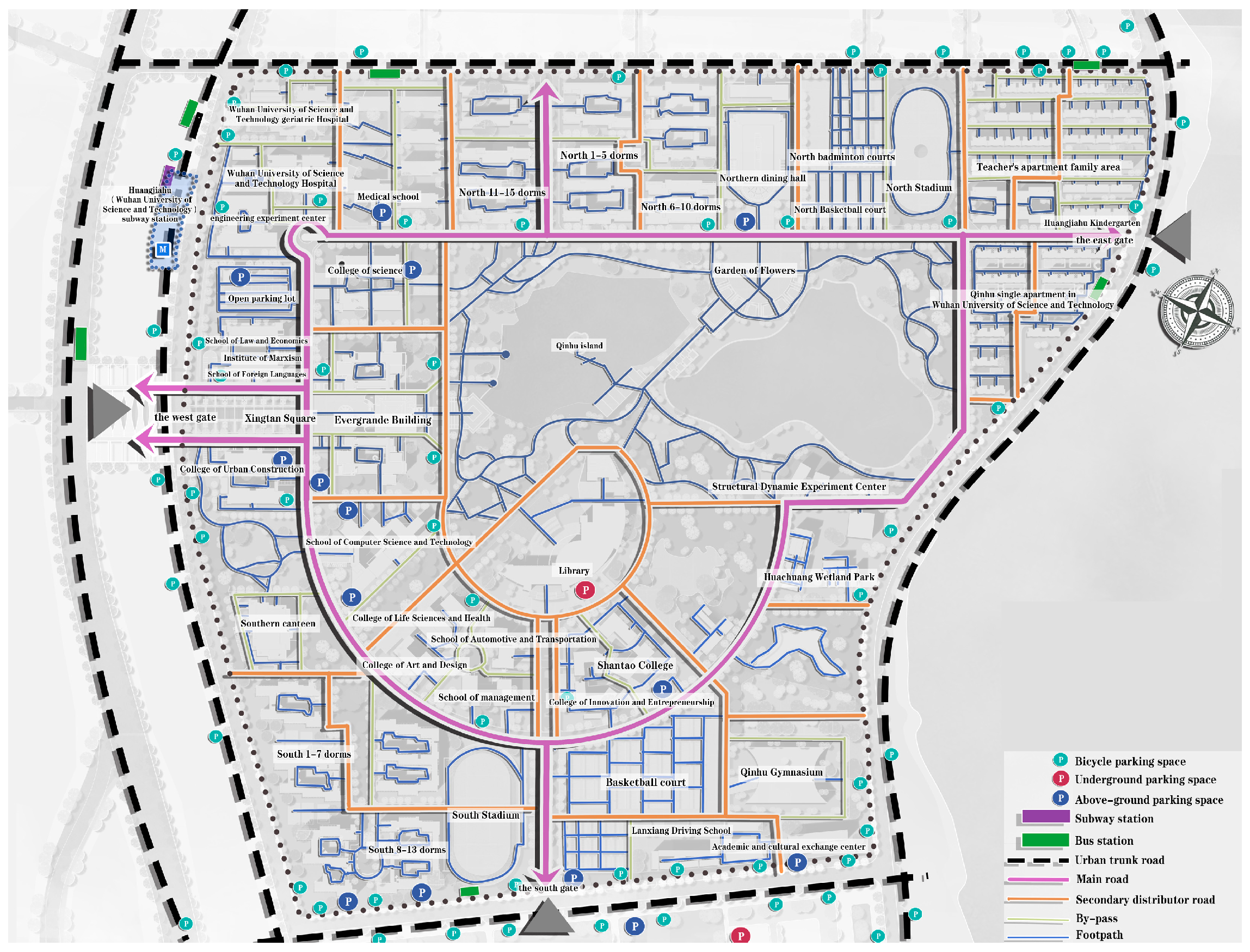
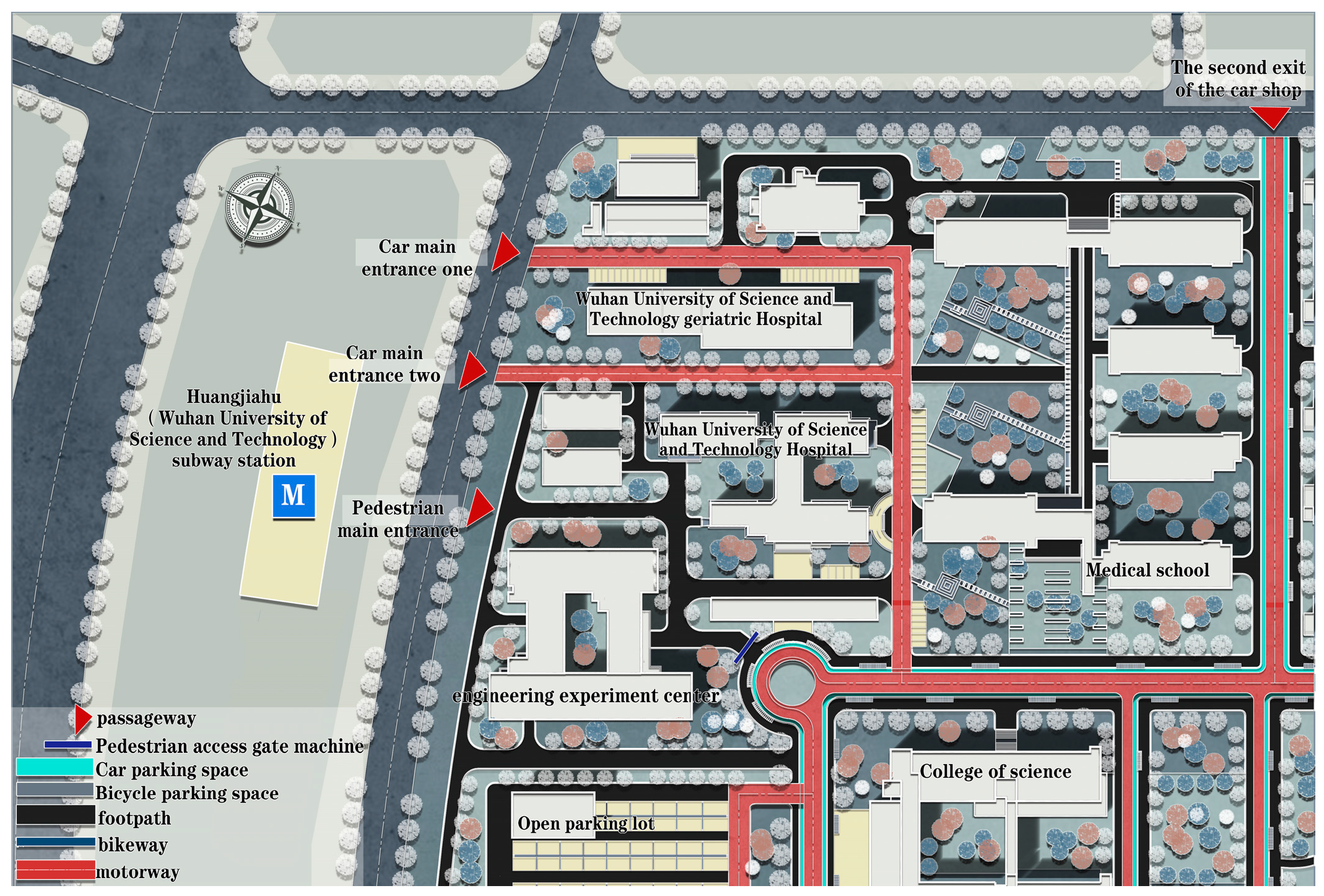
After conducting an in-depth study of the slow-moving transportation system on the Huangjiahu Campus of Wuhan University of Science and Technology, we identified several issues that need to be addressed. Since its completion in September 2005, the campus has provided a place for nearly 22,000 students to study and live, with its expansive area of 1.8 km
2. As shown in
Figure 1, the traffic system design of the campus is mainly centered on the artificial lake and the teaching area, forming a pattern with a circular main road as the main axis, supplemented by radial secondary roads and a square grid of side roads. While this design has successfully optimized motor vehicle flow, the planning for slow-moving traffic remains inadequate.
Currently, the slow road on campus is mostly shared with motorized roads, and this design restricts the space for pedestrians to a certain extent, and there are irregularities in parking management, resulting in frequent occupation of non-motorized roads. Together, these factors not only affect the planning and design of the slow-moving system, but also lack careful consideration and humanistic care for the slow-moving transportation needs of the campus. According to the 2023 Campus Transportation Survey, over 60% of students and faculty experience inconvenience when walking or cycling on campus, with 45% of respondents identifying discontinuous slow-moving paths and parking issues as primary concerns. Results of the 2023 Campus Transportation Survey show that more than 60% of students and faculty feel inconvenienced when walking or cycling on campus.
As schools grow in size and student enrollment increases, the issue of pedestrian–vehicle conflicts is becoming more pronounced. The Spring 2024 Campus Safety Report indicated a 17% increase in slow-moving-related accidents compared to the same period last year. In addition, the beautiful natural environment on campus is not being fully utilized, which not only affects the efficiency of transportation on campus, but also diminishes the vitality and attractiveness of the campus.
In view of the above problems, we propose to optimize the design of the campus slow-moving system. Through measures such as re-planning the road layout, improving parking management, adding slow-moving transportation facilities, enhancing the environmental design of the campus, strengthening safety education and publicity, as well as conducting regular traffic surveys, the traffic efficiency and environmental quality of the campus can be significantly improved, while the vitality and attractiveness of the campus can be enhanced at the same time.
3.2. Research Method
The PLPS (Public Life–Public Space) research [
18] method was created by Professor Jan Gehl, a famous Danish urban planner, and is a research method which specifically focuses on the spatial environment of walking and cycling transportation and facilities. This method not only examines slow transportation itself but also considers the relationship between slow transportation and other modes of transport, as well as the impact of the travel environment on slow transportation. Through multi-level and comprehensive consideration, the PLPS research method can provide a deeper understanding of the current situation and problems of the slow transportation system, and then provide a scientific basis for the planning and design of slow transportation.
3.3. Research Content and Analysis Results
3.3.1. Usage of Slow-Moving Roads
Pedestrian flow and traffic flow statistics [
19]: The method of roadside manual observation was mainly adopted, which was carried out throughout the day and over different time periods, similar to the use of motor vehicle cross-section flow statistics. Pedestrian flow was mainly used to identify the high-frequency areas and peak hours of pedestrian walking trips within the Huangjiahu Campus, and to assess the carrying capacity of the existing campus slow-moving system (a schematic of the existing slow-moving system is shown in
Figure 2). It was also used in conjunction with vehicle flow statistics to analyze potential areas and time periods for pedestrian–vehicle conflicts.
Stopping activity statistics [
19]: These were used mainly to reveal the stopping behavior of students and faculty within the campus; the analysis depicts the changing usage patterns of pedestrians on streets, plazas, landscape nodes, etc., over a 24 h period, which provides a basis for improving public space and the slow-moving environment. From the results of the stay activity statistics of Huangjiahu Campus, it can be seen that the outdoor stay activities inside the campus are mostly sports behaviors, and the stay time for the main landscape and traffic nodes inside the campus is generally shorter, which leads to a good ecological environment and the outdoor public space of the campus not being effectively developed.
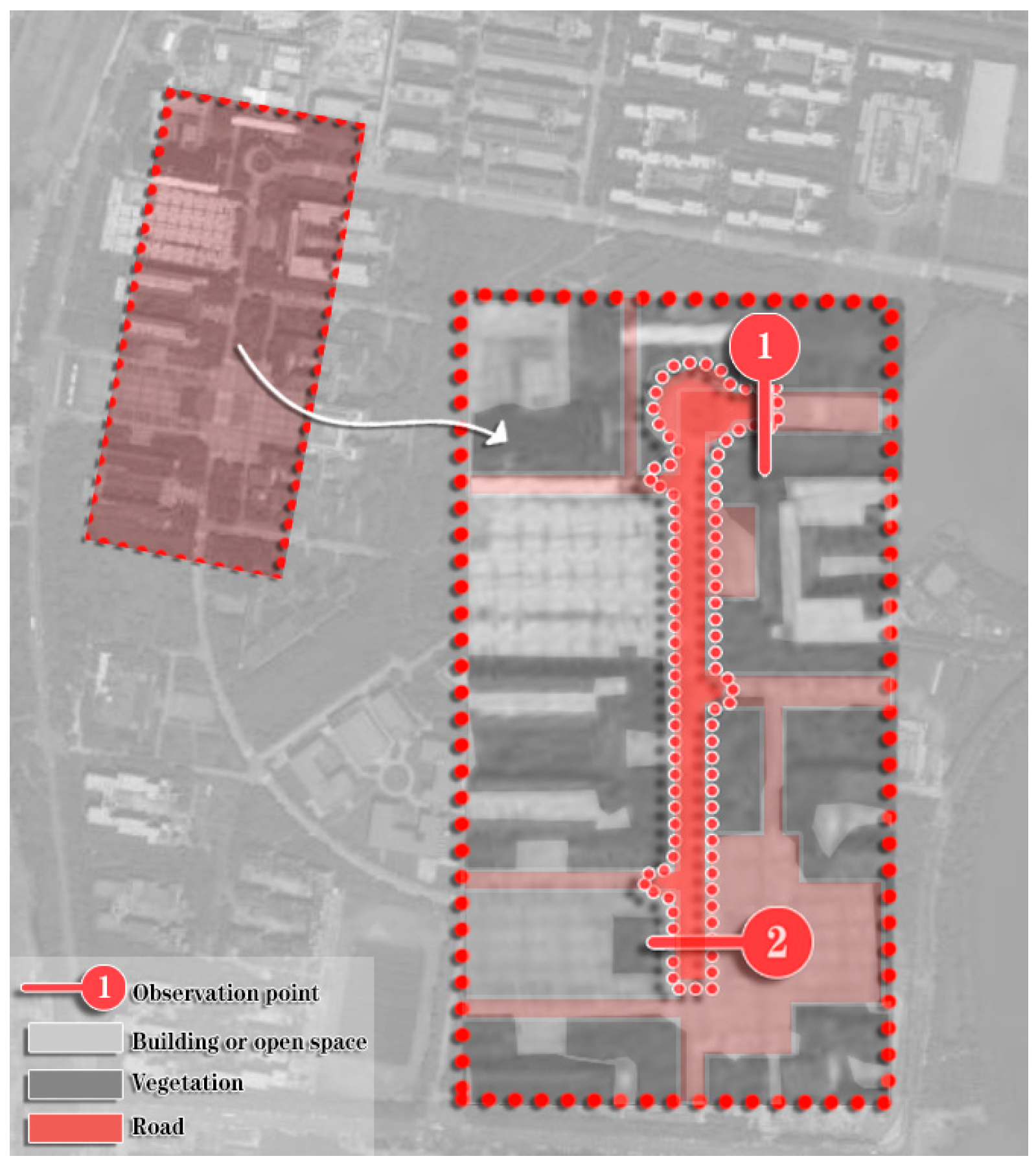
The specific method of the research was as follows: in the weekdays and weekends, a day with good weather was chosen to conduct research, to ensure that the research results were typical. The research example is shown in
Figure 3. Generally, for each research point, a group of three people carried out fixed-point research, over the time range of 8:00–22:00; for each hour, data were gathered successively for the first 30 min for pedestrians, bicycles, and motor vehicles, and traffic flow statistics were taken every 10 min. Every two hours, some of the remaining time was used for other statistical activities. The necessary research materials are illustrated in
Figure 4 and
Figure 5.
3.3.2. Spatial Quality of Slow Roads
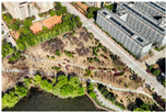
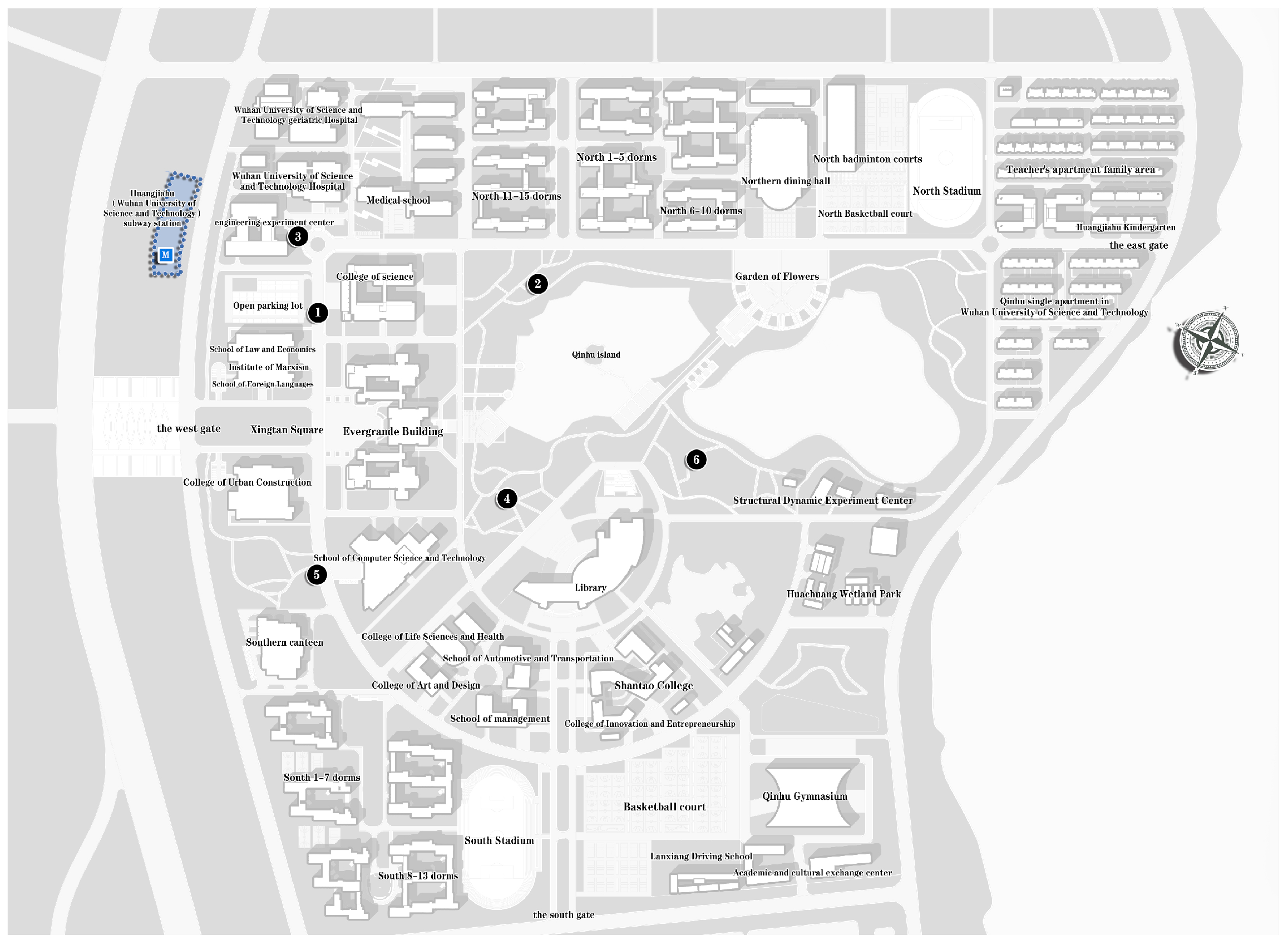
The slow road system at the Huangjiahu Campus is broadly categorized into two types: the slow roads running parallel to motor vehicle roads, serving as the primary routes connecting the teaching and living areas, and the landscaped paths surrounding the campus center, primarily catering to the daily recreational and relaxation needs of students and faculty. This section presents a comprehensive quality assessment of these slow-moving spaces (specific observation locations for the assessment are shown in
Figure 6), analyzing them in depth from three perspectives: safety, convenience, and comfort (specific issues analyzed as shown in
Table 1).
- (1)
Safety: The design of the campus’s main arterial roads complies with the specific requirements of the Urban Road Engineering Design Code (CJJ 37-2012), configured with two-way lanes, and bicycle lanes and elevated sidewalks are set on both sides, which provide a safer passage experience for pedestrians. Although the distribution of street lights is relatively uniform, the lighting quality is suboptimal, especially at corners and intersections, where some lights flicker or provide insufficient illumination, posing safety risks for nighttime slow-moving transportation. Additionally, the landscape layout of the slow-moving roads lacks proper traffic signs and lighting facilities, failing to ensure a safe walking experience during non-peak hours, leaving these areas largely unoccupied at night.
- (2)
Convenience: The campus main road network is complete, effectively connecting the main buildings and public service facilities, but there is a lack of connectivity with off-campus urban public transportation, which is manifested in the fact that the campus entrance and exit to the subway station are equipped with gates for pedestrians only, which is inconvenient for the students who are going to and from the campus with bulky baggage and bicycles and affects the efficiency of the passage. In addition, most of the slow roads arranged with the landscape are distributed irregularly, failing to form a complete network, and the width of the road is not standardized, affecting the consistency of the slow walk.
- (3)
Comfort: While green plants are arranged along both sides of the campus’s main roads, they reduce the available walking space. Additionally, the landscape layout lacks sufficient rest areas and seating, and there are no prominent landscape nodes to guide the design, resulting in disorganized and lengthy pathways that diminish the walking experience.
4. Analysis and Evaluation of Overall Satisfaction of Slow-Walking System
4.1. Selection of Slow-Walking System Satisfaction Indicators
To develop a highly feasible low-carbon evaluation index system for the campus slow-moving system, this study was based on theories related to low-carbon cities and slow-moving systems. This was achieved through the expert consultation method, analysis, the induction method, and the above field research data; referring to the relevant construction standards at home and abroad, the existing low-carbon transportation evaluation indexes, and the evaluation indexes of the slow-moving system [
20]; and with the goal of promoting the low-carbon travel behavior of campus teachers and students and improving the sustainability of the campus environment [
21]. The first step was to divide the campus area according to pedestrian and vehicular traffic flow and the quality of slow-moving roads, and then initially come up with six first-level factors affecting slow-moving transportation. Then, we screened 41 specific evaluation indexes of campus slow-moving traffic satisfaction by combining the multi-dimensional theories of safety, convenience, and comfort (secondary factors), and finally distributed the questionnaires [
22], as shown in
Table 2.
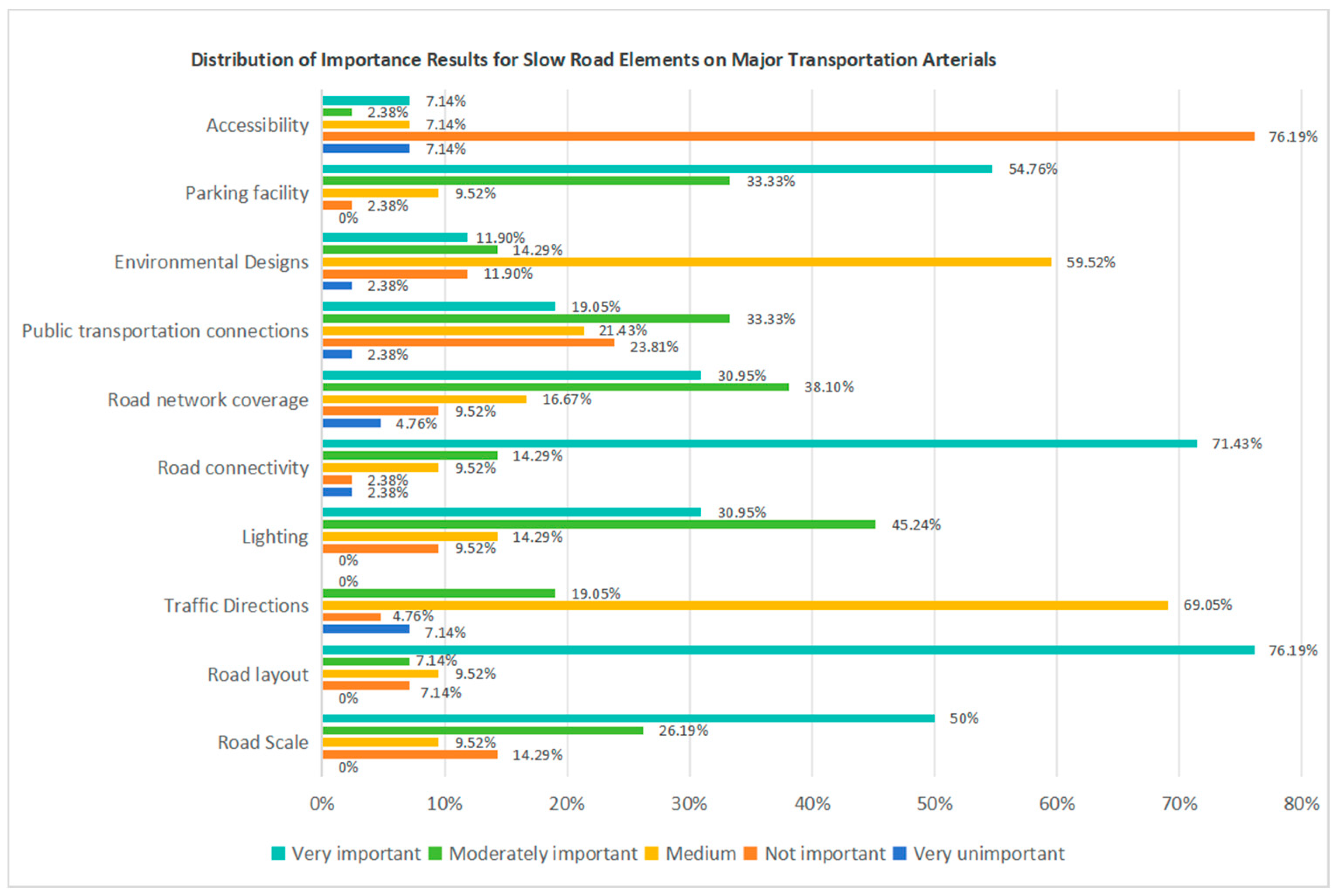
In this study, the quantitative analysis of importance indicators was conducted using the Likert Scale method (Likert Scale). By setting five levels of judgment criteria, i.e., very unimportant (1), unimportant (2), average (3), relatively important (4), and very important (5), the importance scores of 41 indicators in the questionnaire were collected and sorted out from six levels, as shown in
Table 2, and the data distribution charts shown in
Figure 7 were drawn for the results of importance at each level. Finally, by calculating the collected indicator scores, a total sum of 153.825 and an average score of 3.752 were obtained, indicating the overall satisfaction level. Further, 26 indicators with scores higher than the average were extracted as key indicators for the implementation of the later satisfaction research.
4.2. Satisfaction Survey Implementation
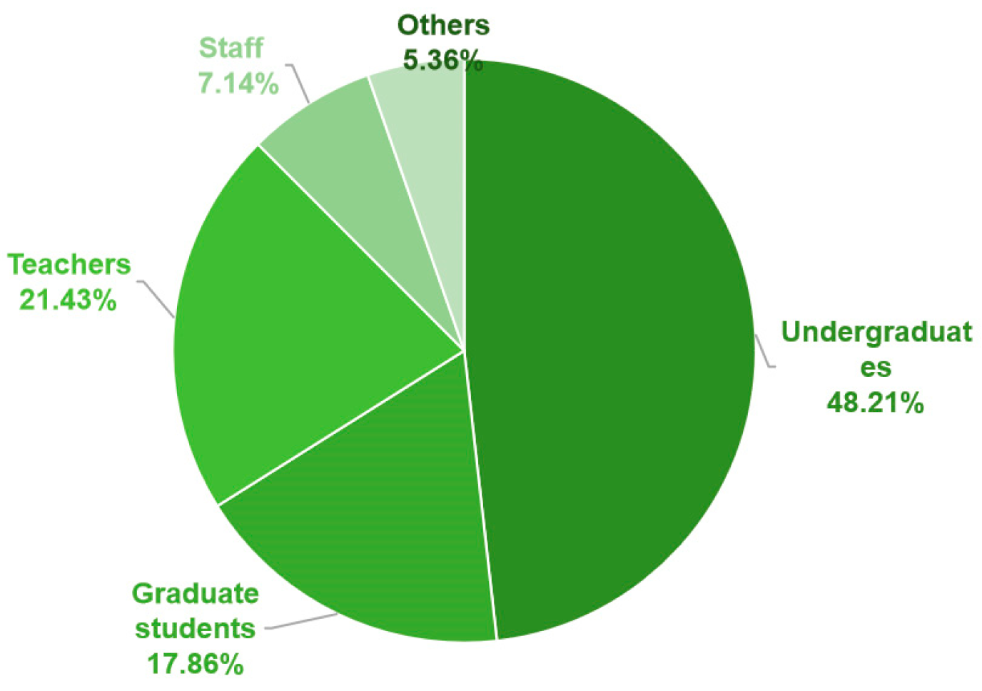
The respondents of this satisfaction survey included students, faculty, and staff from Huangjiahu Campus of Wuhan University of Science and Technology (Examples of specific percentages of respondents and gender ratios are shown in
Figure 8 and
Figure 9). The survey, conducted in June 2024, utilized a combination of online questionnaires and on-site distribution. A total of 115 questionnaires were distributed, of which 112 were validly completed, resulting in an effective recovery rate of 97.39%. The participants were 52.68% male and 47.32% female, reflecting a relatively balanced gender ratio.
4.3. Satisfaction Evaluation of Campus Slow-Walking System
4.3.1. Methods of Analysis
Importance–Performance Analysis (IPA) [
23] is a tool used to evaluate the importance of various attributes in a service or product and the corresponding customer satisfaction with those attributes. Originally proposed by Martilla and James, this method divides a two-dimensional matrix into four quadrants, with importance as the horizontal axis and perceived performance (i.e., satisfaction) as the vertical axis, using the overall averages of importance and perceived performance as the cutoff points. The second quadrant, where importance is high but satisfaction is low, represents the key area for improvement.
This approach allows for the effective identification and prioritization of key issues within the slow-moving system, thereby enhancing both the overall quality of the campus environment and user satisfaction. The data obtained from the questionnaire were analyzed using the IPA formula, yielding quantitative results for the importance and satisfaction of each indicator. The formula is as follows:
where
IPAI is the Importance–Performance Analysis Index (i.e., short for IPA Index);
I is importance;
P is satisfaction.
4.3.2. Descriptive Results Analysis
The specific results of the evaluation of satisfaction and importance in the 112 valid questionnaires are shown in
Table 3 below.
The evaluation results reveal that the importance scores range from 2.125 to 4.575, with an overall mean of 3.735. This indicates a high perception of the importance of the slow transportation system indicators among respondents, with most indicators rated as “important” or “relatively important”. Specifically, “Slow-moving road planning for major traffic arteries”, “Slow-moving road public transportation connections for major traffic arteries”, “Slow-moving road parking facilities in dormitory areas”, “Slow-moving road parking facilities in academic areas”, and “Slow-moving road gate entrance and exit scales at subway connections” received high importance ratings. This suggests that these aspects are particularly crucial for users of the campus slow-moving system. Conversely, the importance ratings for “design of slow-moving road environment in teaching areas”, “scale of slow-moving road in landscaped areas”, and “degree of improvement of overall slow-moving road facilities” are relatively low. This suggests that these aspects are considered lower priorities by users of the campus slow-moving system.
The overall mean satisfaction value for the slow-moving system is 2.625, indicating that users’ satisfaction with the current system needs improvement, with the overall satisfaction level falling between “not very satisfied” and “satisfied”. Specifically, users are satisfied with “slow-moving road lighting facilities on major traffic arteries”, “slow-moving road connectivity in dormitory areas”, “slow-moving road lighting facilities in teaching areas”, and “overall slow-moving road lighting facilities”. “Overall slow-moving road network coverage” is also rated higher, indicating better performance in this area and greater user satisfaction. However, satisfaction ratings for indicators such as “scale of slow-moving roads on major transportation arteries”, “environmental design of slow-moving roads on major transportation arteries”, “parking facilities on slow-moving roads in dormitory areas”, and “planning for slow-moving roads at metro connections” indicate significant room for improvement. Addressing these areas is crucial for enhancing overall user satisfaction and the performance of the campus slow-moving system.
4.3.3. Analysis of IPA Model Results
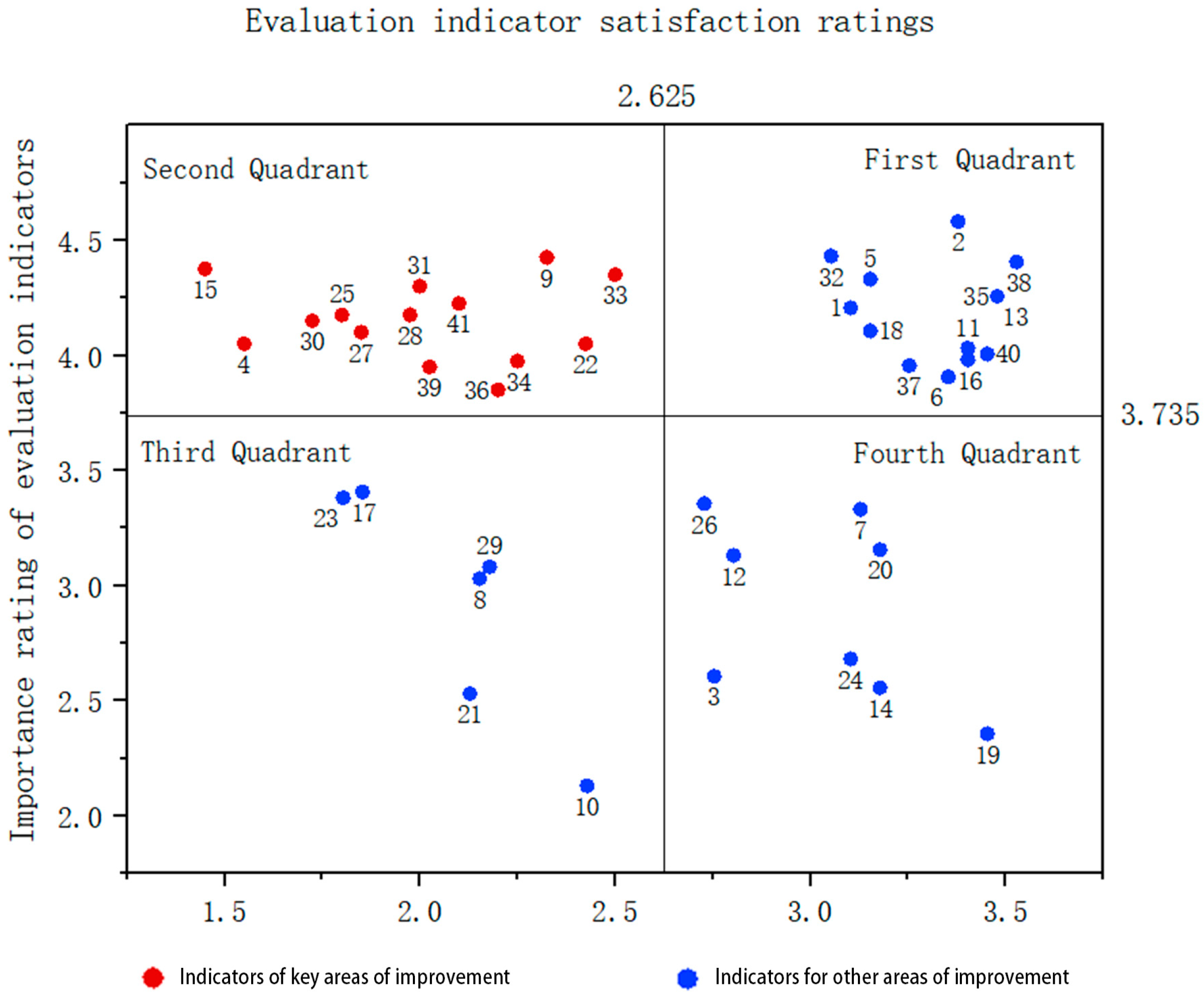
This study identifies key areas for improvement in the campus slow-moving system through IPA modeling analysis. The model was constructed using the mean values of user ratings for importance and satisfaction for each indicator (
Figure 10), with the horizontal axis representing satisfaction and the vertical axis representing importance. Data analysis yielded an overall mean of 3.735 for importance and 2.625 for satisfaction. The identified intersection (2.625, 3.735) delineated the four quadrants of the IPA model, leading to a paired-sample analysis of metrics within these quadrants and revealing varying user perceptions of the importance and satisfaction of these metrics.
Quadrant 1: represents indicators of high importance and high satisfaction, reflecting the core strengths of the campus slow-moving system.
Quadrant 2: highlights metrics that are highly important but have low satisfaction, identifying key areas for improvement to enhance system performance.
Quadrant 3: includes indicators of low importance and low satisfaction, contributing minimally to overall improvement.
Quadrant 4: contains metrics of low importance but high user satisfaction, indicating that performance exceeds user expectations.
The study will focus on Quadrant II metrics (i.e., the points marked in red in
Figure 10), as optimizing these is crucial for improving user satisfaction and system performance. Improvement measures will be developed for these indicators to ensure the ongoing enhancement of services and facilities.
4.3.4. Satisfaction Findings
Through IPA, from the point of view of slow-moving area zoning, the satisfaction level of slow-moving traffic in the main landscape area and the subway connection is low; from the point of view of the overall slow-moving traffic, there are four serious problems in the overall road planning of the campus, the hierarchical division, the public transportation connection, and the slow-moving facilities, which are the key parts to be improved, and the corresponding improvement strategies need to be put forward.
After the above research and evaluation, the main problems of the current slow-moving transportation system of Huangjiahu Campus of Wuhan University of Science and Technology are as follows: (1) the road sections near the teaching area are often congested during the peak hours, which affects the smoothness of the traffic; (2) some of the roads are improperly planned and divided into levels, which leads to the need for detours for the students and the staff; (3) the main traffic arteries in the campus are not smoothly connected with the urban public transportation, which restricts the traffic connection between the campus and the outside world; (4) the use rate of some sidewalks is not high, and the phenomenon of pedestrian–vehicle mixing is common, which is a potential safety hazard; (5) there are insufficient non-motorized parking facilities on campus, which leads to the occupation of part of the walking space; (6) the design of some slow-moving facilities, such as lighting facilities and recreational facilities, is not reasonable enough and needs to be optimized; and (7) the overall slow-moving traffic safety, comfort, and convenience need to be upgraded.
5. Strategies for Optimizing the Campus Slow-Moving Transportation System
The principle of optimizing the campus slow-moving transportation system is to ensure its safety, convenience, comfort, and sustainability, thereby promoting the harmonious development of the campus environment and enhancing the quality of campus life for teachers and students.
5.1. Overall Optimization of Campus Slow-Moving Transportation System
5.1.1. Safety
- (1)
Road scale: In accordance with the “Urban Road Engineering Design Code”, this study refines the design of campus slow-moving roads, ensuring that the minimum width of sidewalks and bicycle lanes exceeds 1.5 m, thereby providing adequate space for pedestrians and cyclists. Simultaneously, the turning radius is adjusted to decrease vehicle turning speeds and reduce the risk of traffic accidents. Additionally, in the road cross-section design, a separated layout [
24] is employed to clearly distinguish between slow-moving areas and motorized vehicles, enhancing safety through green belts or physical isolation facilities.
- (2)
Road planning and hierarchical division: This study reassesses and adjusts campus road planning to ensure the continuity and logic of the slow-moving transportation network [
25]. Slow-moving priority zones are established during peak hours and in high pedestrian and vehicular traffic areas, with traffic control measures implemented to reduce the impact of motorized vehicles on pedestrians. Adjustments to the road network layout include a hierarchical and rationalized design of the motorized road system, downgrading main roads within the campus to secondary roads arranged in a circular pattern along the campus perimeter. By establishing different levels of roads, the relationship between slow and motorized travel is coordinated, promoting slow travel in line with low-carbon principles.
- (3)
Traffic indication and lighting facilities: This study enhances the visibility and recognition of traffic signs and pavement markings on campus through updates and additions. It also includes the addition and upgrading of lighting facilities at campus intersections, corners, and pedestrian crossings to ensure safety for slow-moving traffic at night and in adverse weather conditions. Specific requirements follow the Urban Road Lighting Design Standards to ensure optimized lighting layout and brightness, reducing dead zones and improving visibility in slow-moving areas.
5.1.2. Convenience
- (1)
Road connectivity: This study proposes the addition of a slow-moving corridor that directly connects to the core campus areas, aiming to shorten walking and cycling paths for students and faculty and improve access efficiency [
26]. By optimizing traffic signals at key intersections and prioritizing slow-moving traffic, combined with an intelligent traffic monitoring system that dynamically adjusts signals to real-time demand, the flow of slow-moving traffic is ensured.
- (2)
Network coverage: This study advocates the development of auxiliary slow-moving paths and the utilization of campus green spaces and undeveloped areas to create a dense slow-moving network. This approach aims to improve campus accessibility, offer diversified travel options, and enrich the slow-walking experience for both students and faculty.
- (3)
Public transportation feeder: This study suggests establishing a clear wayfinding system at major public transportation hubs around the campus to quickly guide students and faculty to feeder points, ensuring a seamless connection with the campus slow-moving paths. Through collaboration with the city transportation department, campus bus services should be adjusted according to the travel patterns of students and faculty, enhancing the timeliness and coverage of the service. Additionally, adding bicycle parking facilities at feeder points is recommended to encourage bicycle use as a feeder mode, promote multi-modal transportation integration [
27], and enhance the overall efficiency and convenience of the campus transportation system.
5.1.3. Comfort
- (1)
Environmental design: This study emphasizes the strategic planning of green spaces [
28], aiming for a harmonious integration of ecological esthetics and spatial efficiency. Through the comprehensive design and planning of campus greenery and landscapes, the study aims to establish a cohesive green network, ensuring both the adequacy and continuity of walking spaces. The green space configuration will consider pedestrian needs and visual appeal, avoiding the overuse of slow-moving areas, and ensuring that teachers and students can enjoy the environment while experiencing a spacious and comfortable walk.
- (2)
Improvement of facilities: The study aims to optimize signage within landscape areas, adding clear signs and maps to effectively guide students and faculty to key landscape nodes, thereby enhancing campus navigation. The plan includes adding leisure seats, pavilions, and viewing platforms to offer teachers and students diverse spaces for rest and socialization, encouraging them to linger and interact in the scenic environment. Additionally, bicycle parking facilities will be enhanced, including additional racks and parking shelters, to ensure the convenience and comfort of the slow-moving network, allowing teachers and students to relax and enjoy the campus scenery.
- (3)
Accessible design: This study is dedicated to creating a slow-moving system that is accessible and inclusive for all users, including those with mobility challenges. The focus is on optimizing barrier-free access in key areas, such as installing ramps and tactile pathways at major building entrances, slow-moving paths, and landscape nodes, ensuring that all new or renovated slow-moving facilities meet accessibility standards to enhance campus inclusivity.
5.2. Core Area and Major Node Improvements
5.2.1. Improvement of Seeking Knowledge Road
- (1)
Importance discussion:
Seeking Knowledge Road plays a crucial role in the campus transportation network, connecting the North Dormitory and Teachers’ Apartments to the main teaching area (Heng Building), thereby providing a convenient route for both teachers and students. Additionally, this road serves as a vital route for motor vehicles accessing the main underground parking lot, playing an irreplaceable role in maintaining the normal operation of campus infrastructure.
- (2)
Analysis of the current situation and problems:
The slow-moving system on this road section faces several issues, primarily manifested in the severe pedestrian–vehicle mixing during peak hours, inefficient space utilization due to the mixed arrangement of motorized vehicles, non-motorized vehicles, and sidewalks, as well as the non-motorized parking area directly on the roadway, which increases the risk of traffic accidents. These problems not only impact the efficiency of campus traffic but also pose significant safety risks to students and faculty.
- (3)
Solution:
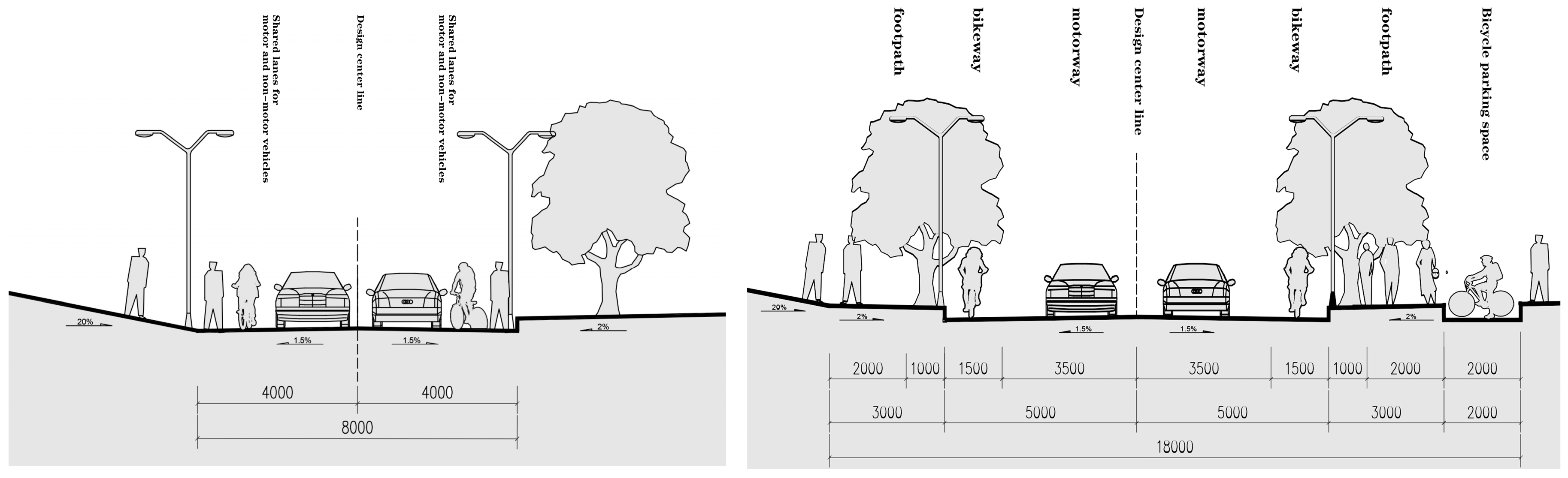
As illustrated in
Figure 11, the improved design of Seeking Knowledge Road’s cross-section focuses on the following aspects [
24]. First, the sidewalk area is elevated, and the space created by the green setback is used for planning the non-motorized parking area. Simultaneously, a dedicated bicycle lane and motor vehicle lane are established to achieve spatial separation and functional division. Additionally, by simplifying the traffic signal and signage system, clear communication of traffic rules is ensured. An intelligent monitoring system is also introduced to improve traffic signals, enhancing the safety and efficiency of campus slow-moving traffic [
29].
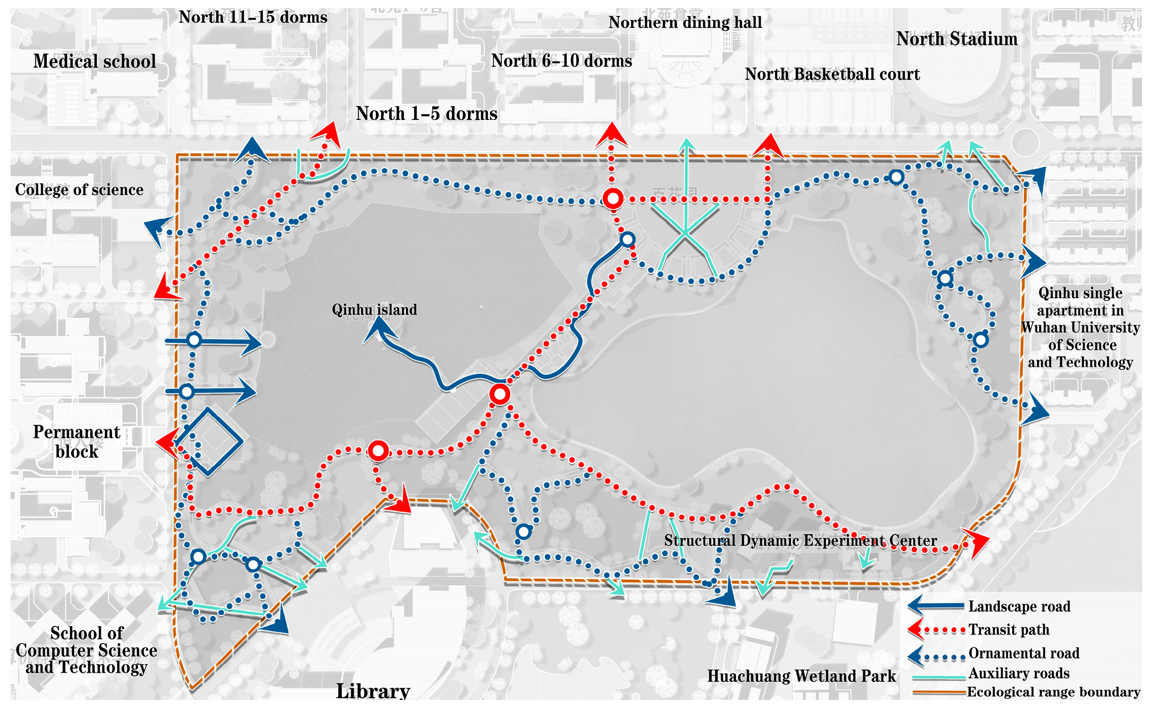
5.2.2. The Improvement of Slow Roads in the Main Landscape Area (Qinhu)
- (1)
Importance discussion:
As the center section of campus planning, Qinhu area is adjacent to key functional areas such as the dormitory area, teaching area, and library, constituting the main axis of campus daily activities. Additionally, the area boasts high-quality ecological resources with significant environmental value and landscape potential, yet it remains underdeveloped and underutilized.
- (2)
An analysis of the current situation and problems:
The slow-moving system in this area faces a series of issues, including inconsistent road widths, disorganized layouts, and a lack of effective guidance, lighting, and recreational facilities. These issues not only impact the efficiency and safety of slow-moving traffic but also restrict the area’s potential to serve as a cultural and recreational space on campus.
- (3)
Solution:
Based on preliminary research findings, this study proposes a comprehensive improvement strategy, as detailed in
Table 4, aiming to enhance the passability and recreation of this road section to meet the needs of different user groups [
30]. The specific improvement plan is illustrated in
Figure 12.
5.2.3. Improvement of Slow Road at Connection with Metro
- (1)
Importance discussion:
This section of the road holds a strategic position in the campus transportation network, serving as a key route connecting the North District dormitory area, the teachers’ apartments, and the subway station. It is particularly crucial during weekends and vacations when it accommodates a high volume of students transporting luggage. The layout of the two entrances and exits in this area is crucial: one is the internal pedestrian entrance to the campus, equipped with gates, and the other is the open entrance to the outside world, where there is currently a mix of pedestrian and vehicular traffic. The campus hospital is located in the middle of these two entrances and exits, which not only serves the internal campus, but is also open to the public, making it an important access point for students and staff to seek quick medical treatment in case of emergency.
- (2)
An Analysis of the current situation and problems:
Analyzed from the layout point of view, there are several problems with the slow-moving system in this section. In the entrance part that is open to the inside, the gate design restricts the passage efficiency of people carrying baggage, there are a lot of non-motorized vehicle parking problems in the no-parking area of the traffic circle, and the unreasonable layout of the greenery restricts the space for pedestrians. The mixed arrangement of vehicular and pedestrian entrances and exits in the external section leads to the mixing of people and vehicles, which increases the potential traffic safety hazards. The middle section has a certain slope and is equipped with speed bumps, which impedes the smooth passage of pedestrians to a certain extent.
- (3)
Solution:
To address the issues identified in the slow-moving system along this road section, this study proposes improvement strategies based on the analysis of the current layout at the subway connection. These strategies, detailed in
Table 5, aim to enhance overall access efficiency and safety, meeting the needs of students, faculty, staff, and visitors. The improved layout is illustrated in
Figure 13.
5.3. Preliminary Evaluation of Improvement Effect
Through the series of systematic improvement measures for slow-moving traffic outlined in
Section 4.2, this study employs capacity and time cost as evaluation indices to perform a preliminary assessment of the design outcomes post-improvement [
31].
- (1)
Capacity evaluation: We expect a significant increase in the capacity of the main thoroughfares on campus after the improvements. This improvement is accomplished by widening sidewalks and bike paths, introducing traffic islands and safety zones, and refining the layout of intersections, thus ensuring the smooth movement of pedestrians and cyclists. A comparative analysis of road capacity before and after the improvements is provided in
Table 6. It is evident that a significant capacity increase has been achieved through macro-level planning and micro-level modifications of the slow traffic network.
- (2)
Time cost evaluation: In this study, ArcGIS was employed to classify the land characteristics of the case area, dividing it into multiple transportation subdivisions. Using land use data, slow-moving travel rates, per capita trip numbers, and other relevant parameters, TransCAD (Version 9.0) software was applied to estimate the attraction potential of slow-moving transportation modes within each subdivision and to calculate the shortest time costs for slow-moving traffic between them.
The results demonstrate that by introducing direct pathways, optimizing signal timing, and enhancing road connectivity, the time costs for all slow-moving routes are significantly reduced following design optimization, with reductions ranging from 12.72% to 19.18%. The systematic improvements have proven to be both effective and convenient.
In summary, the improved design of the slow-moving traffic system at the Huangjiahu Campus of Wuhan University of Science and Technology has led to substantial improvements in both capacity and time cost reductions. These improvements not only enhance the travel experience for faculty and students but also provide strong support for the sustainable development of campus transportation.
6. Conclusions
This study focuses on the Huangjiahu Campus of Wuhan University of Science and Technology as the research subject. Based on the principles of low-carbon and sustainable development, the PLPS research method and questionnaire analysis were employed to comprehensively evaluate the campus slow-moving system. The study found that the campus slow-moving system is deficient in safety, convenience, and comfort, particularly regarding the sharing of slow-moving roads with motorized traffic, insufficient nighttime lighting, and a lack of parking facilities. Through IPA, we identified key factors contributing to low user satisfaction, including the irrational planning of slow-moving roads, inadequate public transportation connections, and unsatisfactory design of slow-moving environments.
To address these issues, this study proposes a series of optimization strategies aimed at enhancing the safety, convenience, and comfort of the campus slow-moving system. The proposed optimization measures primarily include the following:
- (1)
Safety enhancement: the safety of pedestrians and cyclists is improved through adjustments to road scale, the re-planning of road design, and the installation of additional lighting and traffic signage.
- (2)
Convenience enhancement: the slow-moving network has been optimized, with additional passages leading directly to the campus core and improved connections to urban public transportation, enhancing travel efficiency for students and faculty.
- (3)
Comfort improvement: improvements in environmental design and barrier-free facilities provide a more comfortable and enjoyable slow-moving experience for students and faculty.
These optimization measures are expected to significantly enhance the capacity of major arterial roads on campus, such as a 35.57% increase in the capacity of the western section of Zhixing Road, while reducing the time cost of slow-moving paths by an average of 12.72% to 19.18%. By reducing students’ and faculty members’ dependence on motorized vehicles, these measures also contribute to reducing campus carbon emissions and promoting a healthy lifestyle.
The optimization strategies presented in this study not only offer theoretical support and practical solutions for improving the slow-moving system on the Huangjiahu Campus but also serve as a reference for optimizing slow-moving systems at other universities. In the future, it is recommended to further explore strategies for integrating multi-modal transportation [
27], employ intelligent management technologies to enhance system efficiency, and conduct in-depth analyses of user behavior to better meet the travel needs of faculty and students. Through these measures, the sustainable development of the campus transportation system can be effectively promoted [
32], addressing the global trend in low-carbon development and making a positive contribution to the creation of a green, healthy, and vibrant campus environment.
Author Contributions
Conceptualization, H.Y.; methodology, H.Y.; formal analysis, H.Y.; investigation, H.Y. and Y.Q.; resources, X.X. and T.L.; data curation, H.Y.; writing—original draft preparation, H.Y.; writing—review and editing, H.Y. and X.X.; visualization, X.X., H.Y., and Y.Q.; supervision, X.X.; project administration, X.X. and H.Y.; funding acquisition, X.X. and T.L. All authors have read and agreed to the published version of the manuscript.
Funding
This research was funded by the National Natural Science Foundation of China, grant number 42401568. Project title: Simulation and Optimization of Electric Vehicle Public Charging Station Layout Based on Behavior Mining and Intelligent Body Modeling. Project leader: Xiaotang Xia.
Institutional Review Board Statement
Ethical review and approval were waived for this study due to the absence of a local specialized ethics review body. The college institution conducted the ethical review on behalf of the participants. It confirmed that the research design and protocol were scientifically sound, rational, fair, and free from bias, ensuring no harm or risk to participants. Recruitment was based on voluntary and informed consent, with rights and privacy protections in place. The study was devoid of conflicts of interest and complied with ethical and legal standards. Consequently, the university institution formally granted an ethics review waiver, rendering further ethical review and approval unnecessary for this study.
Informed Consent Statement
Not applicable.
Data Availability Statement
The original contributions presented in the study are included in the article, further inquiries can be directed to the corresponding author.
Conflicts of Interest
The authors declare no conflicts of interest.
References
- Zhang, Y. Reflections on the Development of Slow Traffic Systems. Sci. Technol. Innov. Appl. 2012, 23, 329. [Google Scholar]
- Meng, D. Research on the Design of the Slow Traffic System in the Campus of Dalian University of Technology. Doctoral Dissertation, Dalian University of Technology, Dalian, China, 2015. [Google Scholar]
- Luo, B.J. Optimization of University Campus Road Traffic Systems. Doctoral Dissertation, Chongqing Jiaotong University, Chongqing, China, 2009. [Google Scholar]
- Cao, Y.W. Landscape Research on the Slow Traffic System in University Campuses in Fuzhou City. Doctoral Dissertation, Fujian Agriculture and Forestry University, Fuzhou, China, 2016. [Google Scholar]
- Macioszek, E.; Granà, A.; Krawiec, S. Identification of factors increasing the risk of pedestrian death in road accidents involving a pedestrian with a motor vehicle. Arch. Transp. 2023, 65, 7–25. [Google Scholar] [CrossRef]
- Qin, Q.; Yuan, Z.Z.; Tian, J.F. Research on Planning Methods of Slow Traffic Systems under the Concept of Green Traffic. Planner 2012, 28 (Suppl. S2), 5–10. [Google Scholar]
- Yang, Y.N. Research on the Design of Slow Traffic Systems in Campus Environments. Doctoral Dissertation, Hubei University of Technology, Wuhan, China, 2021. [Google Scholar] [CrossRef]
- Ma, L.; Yang, D. Approach to the Slow-Paced Landscape System in Campus. J. Fujian For. Sci. Technol. 2013, 2, 166–170. [Google Scholar]
- Yin, Y.S. Optimization Research on Slow Traffic in New University Campuses under the Background of Shared Bicycles. Shanxi Archit. 2019, 45, 27–28. [Google Scholar] [CrossRef]
- Chen, L.; Wang, W.; Liu, B.G. Research on the Design of Slow Traffic Systems in Educational Parks Based on the Concept of Green Traffic: A Case Study of Fengqiu Education Park. For. Inventory Plan. 2022, 47, 87–93. [Google Scholar]
- Zhang, X.H. Research on the Planning and Design Methods of University Campus Traffic Based on the Concept of Green Traffic. Doctoral Dissertation, Tianjin University, Tianjin, China, 2017. [Google Scholar]
- Zhou, Y. Traffic Organization Strategies and Practices in Old Campus Areas of Colleges and Universities Based on Slow Priority Areas. Transp. Transp. 2020, 36, 9–12. [Google Scholar]
- Scagni, A.; Maggiolini, M. Data-Based Understanding and Optimization of Sustainability of University Mobility: Two Case Studies. IOP Conf. Ser. Earth Environ. Sci. 2023, 1194, 012009. [Google Scholar] [CrossRef]
- Cappelletti, G.M.; Grilli, L.; Russo, C.; Santoro, D. Benchmarking Sustainable Mobility in Higher Education. Sustainability 2023, 15, 5190. [Google Scholar] [CrossRef]
- Posner, S.M.; Stuart, R. Understanding and Advancing Campus Sustainability Using a Systems Framework. Int. J. Sustain. High. Educ. 2013, 14, 264–277. [Google Scholar] [CrossRef]
- Li, H.; Huang, Y.; Zhong, H.; Wang, G.; Xu, W.; Xue, P.; Xiang, Y. Energy-Carbon-Behavior Nexus: A Campus Case. In Proceedings of the 2023 Panda Forum on Power and Energy (PandaFPE), Chengdu, China, 27–30 April 2023; IEEE: Piscataway, NJ, USA, 2023; pp. 1011–1017. [Google Scholar]
- Sukor, N.S.A.; Hassan, S.A. Analysis of Transportation Energy Consumption: En Route Towards Carbon Reduction for Sustainable Campus. IOP Conf. Ser. Mater. Sci. Eng. 2017, 226, 012055. [Google Scholar] [CrossRef]
- Jiang, Y.; Wang, Y.; Yu, J.; Hu, H.; Villadsen, K.S. Planning and Design Evaluation of Pedestrian and Bicycle Traffic Based on PLPS Survey Method. Urban Transp. China 2011, 9, 28–38. [Google Scholar] [CrossRef]
- Liu, C.Y.; Li, J.; Hui, Y. Design and Planning for Improving Slow Traffic in Suburban University Campuses to Enhance Vitality: A Case Study of Jiading Campus of Tongji University. Compr. Transp. 2017, 39, 50–58. [Google Scholar]
- He, H.C. Evaluation and Optimization of Campus Slow Traffic Systems under the Guidance of Healthy City Orientation. Doctoral Dissertation, Jiangxi Normal University, Nanchang, China, 2023. [Google Scholar] [CrossRef]
- Beringer, A. The Lüneburg Sustainable University Project in International Comparison: An Assessment against North American Peers. Int. J. Sustain. High. Educ. 2007, 8, 446–461. [Google Scholar] [CrossRef]
- Han, Y.N. Research on the Renewal Design of Streets Surrounding Beijing Colleges and Universities under the Guidance of the Slow Traffic System. Doctoral Dissertation, Beijing Jiaotong University, Beijing, China, 2021. [Google Scholar] [CrossRef]
- Sheng, B.W.; Wu, A.Q.; Wang, Y.X.; Guo, Q.L. Research on Satisfaction Survey and Optimization Strategy of Slow Traffic in College Campuses. Traffic Sci. Technol. Manag. 2021, 20, 51–55. [Google Scholar]
- Zhang, Y.; Xia, Y.C. Research on the Construction of University Campus Slow Traffic Space Based on Travel Characteristics: A Case Study of Xihu Campus of Southwest Jiaotong University. City Archit. 2021, 18, 137–139. [Google Scholar] [CrossRef]
- Liu, M.F.; Xiong, S.W. The Properties of Campus Road Traffic Networks. In Proceedings of the 2016 International Conference on Information System and Artificial Intelligence (ISAI), Hong Kong, China, 24–26 June 2016; pp. 603–607. [Google Scholar] [CrossRef]
- Romanowska, A.; Okraszewska, R.; Jamroz, K. A Study of Transport Behavior of Academic Communities. Sustainability 2019, 11, 3519. [Google Scholar] [CrossRef]
- Toor, W.; Havlick, S.W. Transportation and Sustainable Campus Communities: Issues, Examples, Solutions; Island Press: Washington, DC, USA, 2004. [Google Scholar]
- Xu, W.H. Urban “Slow Space” and Greenway Construction. Landsc. Archit. 2012, 06, 155–156. [Google Scholar] [CrossRef]
- Steiner, R.L.; Bejleri, I.; Wheelock, J.L.; Boles, G.; Cahill, M.; Perez, B.O. Understanding and Mapping Institutional Impediments to Walking and Bicycling to School: A Case Study of Hillsborough County, Florida. Transp. Res. Rec. 2008, 2074, 3–11. [Google Scholar] [CrossRef]
- Guan, B.H. A Brief Analysis of the Construction of Campus Slow Traffic Systems under the Background of “Double First-Class” University Construction. Sichuan Archit. 2017, 37, 8–10. [Google Scholar]
- Okraszewska, R.; Romanowska, A.; Wołek, M.; Oskarbski, J.; Birr, K.; Jamroz, K. Integration of a Multilevel Transport System Model into Sustainable Urban Mobility Planning. Sustainability 2018, 10, 479. [Google Scholar] [CrossRef]
- Hancock, L.; Nuttman, S. Engaging Higher Education Institutions in the Challenge of Sustainability: Sustainable Transport as a Catalyst for Action. J. Clean. Prod. 2014, 62, 62–71. [Google Scholar] [CrossRef]
Figure 1.
A general plan of the Huangjiahu Campus.
Figure 1.
A general plan of the Huangjiahu Campus.
Figure 2.
A schematic diagram of the slow-moving pedestrian system at the Huangjiahu Campus.
Figure 2.
A schematic diagram of the slow-moving pedestrian system at the Huangjiahu Campus.
Figure 3.
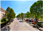
A schematic diagram of observation points for the road usage study.
Figure 3.
A schematic diagram of observation points for the road usage study.
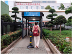
Figure 4.
Research counter.
Figure 4.
Research counter.
Figure 5.
Example chart of observation form.
Figure 5.
Example chart of observation form.
Figure 6.
Schematic diagram of slow-moving system observation nodes in Huangjiahu Campus.
Figure 6.
Schematic diagram of slow-moving system observation nodes in Huangjiahu Campus.
Figure 7.
Distribution of importance results for slow road elements on major transportation arterials.
Figure 7.
Distribution of importance results for slow road elements on major transportation arterials.
Figure 8.
Proportion of respondents in satisfaction questionnaire.
Figure 8.
Proportion of respondents in satisfaction questionnaire.
Figure 9.
Proportion of men and women in satisfaction questionnaire.
Figure 9.
Proportion of men and women in satisfaction questionnaire.
Figure 10.
Overall IPA quadrant analysis of campus slow-moving transportation.
Figure 10.
Overall IPA quadrant analysis of campus slow-moving transportation.
Figure 11.
Comparison of before and after roadway cross-section improvements on Seeking Knowledge Road.
Figure 11.
Comparison of before and after roadway cross-section improvements on Seeking Knowledge Road.
Figure 12.
Schematic of slow-moving path improvements in main landscape area (Qinhu).
Figure 12.
Schematic of slow-moving path improvements in main landscape area (Qinhu).
Figure 13.
Map of slow road improvement at the connection with the subway.
Figure 13.
Map of slow road improvement at the connection with the subway.
Table 1.
Assessment of slow road spatial quality problems.
Table 2.
Slow transportation system satisfaction questionnaire and results.
Table 2.
Slow transportation system satisfaction questionnaire and results.
| Primary Factor | Secondary Factor | Tertiary Factor |
|---|
| Slow-moving roads on main traffic arteries of the university | Security | 1: road scale, 2: road planning, 3: traffic directions, 4: lighting facilities |
| Convenience | 5: road connectivity, 6: road network coverage, 7: public transportation connections |
| Comfort | 8: environmental design, 9: parking facilities, 10: accessibility |
| Dormitory and living service area-related slow-moving traffic | Security | 11: road scale, 12: lighting facilities |
| Convenience | 13: roadway connectivity |
| Comfort | 14: environmental design, 15: parking facilities |
| Slow traffic in teaching area | Security | 16: roadway scale, 17: lighting facilities |
| Convenience | 18: parking facilities |
| Comfort | 19: environmental design, 20: accessibility |
| Slow traffic related to the main landscape area (Qinhu) | Security | 21: roadway scale, 22: roadway planning, 23: traffic directions, 24: lighting facilities |
| Convenience | 25: roadway connectivity |
| Comfort | 26: environmental design, 27: recreational facilities |
| Slow traffic at the connection with the subway | Security | 28: gate entrance/exit roadway scale, 29: traffic direction |
| Convenience | 30: road planning |
| Comfort | 31: parking facilities |
| Slow traffic in the whole school | Security | 32: road scale, 33: road planning, 34: road hierarchy, 35: traffic directions, 36: lighting facilities |
| Convenience | 37: road connectivity, 38: road network coverage, 39: public transportation connections |
| Comfort | 40: environmental design, 41: facility improvement |
Table 3.
The results of the evaluation of the satisfaction and importance of the slow transportation system.
Table 3.
The results of the evaluation of the satisfaction and importance of the slow transportation system.
| Indicators | Importance | Satisfaction |
|---|
| No. | Name | Mean | Standard Deviation | Mean | Standard Deviation |
|---|
| 1 | Slow-moving road scale for major traffic arteries | 4.2 | 0.84 | 2.6 | 0.96 |
| 2 | Slow-moving road planning for major traffic arteries | 4.575 | 1.01 | 3.375 | 0.93 |
| 3 | Slow-moving road traffic signs for major traffic arteries | 2.6 | 0.84 | 2.75 | 1.02 |
| 4 | Slow-moving road lighting for major traffic arteries | 4.05 | 1.05 | 1.55 | 0.78 |
| 5 | Major traffic arterial slow-moving road connectivity | 4.325 | 0.91 | 3.15 | 0.84 |
| 6 | Coverage of slow-moving road network of major traffic arteries | 3.9 | 0.93 | 3.35 | 0.90 |
| 7 | Public transportation connection of slow-moving roads on major traffic arteries | 3.325 | 0.86 | 3.125 | 0.89 |
| 8 | Environmental design of slow-moving roads on major transportation arteries | 3.025 | 1.07 | 2.15 | 0.92 |
| 9 | Parking facilities on slow-moving roads of major transportation arteries | 4.425 | 1.12 | 2.325 | 1.02 |
| 10 | Barrier-free facilities for slow-moving roads on major traffic arteries | 2.125 | 0.86 | 2.425 | 0.93 |
| 11 | Dormitory area slow-moving road scale | 4.025 | 0.82 | 3.4 | 0.85 |
| 12 | Dormitory area slow-moving road lighting | 3.125 | 0.98 | 2.8 | 0.86 |
| 13 | Dormitory area slow-moving road connectivity | 4.25 | 0.94 | 3.475 | 0.94 |
| 14 | Dormitory area slow-moving road environment design | 2.55 | 1.07 | 3.175 | 1.12 |
| 15 | Parking facilities for dormitory area slow-moving roads | 4.375 | 0.93 | 1.45 | 0.86 |
| 16 | Scale of slow-moving road in teaching area | 3.975 | 0.88 | 3.4 | 0.86 |
| 17 | Slow-moving road lighting in teaching area | 3.4 | 0.87 | 1.85 | 0.93 |
| 18 | Parking facilities for slow-moving roads in teaching areas | 4.1 | 0.95 | 3.15 | 0.98 |
| 19 | Slow-moving road environment design for teaching area | 2.35 | 0.84 | 3.45 | 0.79 |
| 20 | Slow-moving road accessibility in teaching area | 3.15 | 0.98 | 3.175 | 1.12 |
| 21 | Scale of slow-moving road in landscape area | 2.525 | 0.93 | 2.125 | 0.86 |
| 22 | Landscape slow-moving road planning | 4.05 | 0.87 | 2.425 | 0.91 |
| 23 | Slow-moving road traffic indication in landscape area | 3.375 | 1.01 | 1.8 | 0.88 |
| 24 | Landscape slow-moving road lighting | 2.675 | 0.92 | 3.1 | 0.97 |
| 25 | Landscape slow-moving road connectivity | 4.175 | 0.86 | 1.8 | 1.06 |
| 26 | Landscape slow-moving road environment design | 3.35 | 0.92 | 2.725 | 0.82 |
| 27 | Landscape slow-moving road leisure facilities | 4.1 | 0.93 | 1.85 | 0.94 |
| 28 | Slow-moving road gate entrance and exit scale at the metro connection | 4.175 | 0.94 | 1.975 | 1.01 |
| 29 | Slow-moving road traffic indication at metro connection | 3.075 | 1.01 | 2.175 | 0.94 |
| 30 | Slow-moving road planning for metro connection | 4.15 | 0.86 | 1.725 | 1.13 |
| 31 | Slow-moving road parking facilities at the metro connection | 4.3 | 0.87 | 2 | 0.96 |
| 32 | Overall slow road scale | 4.425 | 0.82 | 3.05 | 1.06 |
| 33 | Overall slow road planning | 4.35 | 1.01 | 2.5 | 0.95 |
| 34 | Overall slow road hierarchy | 3.975 | 0.86 | 2.25 | 0.87 |
| 35 | Overall slow road traffic indication | 4.25 | 0.89 | 3.475 | 0.86 |
| 36 | Overall slow road lighting | 3.85 | 0.95 | 2.2 | 0.95 |
| 37 | Overall slow-moving road connectivity | 3.95 | 0.87 | 3.25 | 0.77 |
| 38 | Overall slow-moving road network coverage | 4.4 | 0.76 | 3.525 | 0.89 |
| 39 | Overall slow-moving road public transportation connection | 3.95 | 1.01 | 2.025 | 1.08 |
| 40 | Overall slow-moving road environment design | 4 | 0.95 | 3.45 | 0.91 |
| 41 | Overall slow-moving road facility improvement | 4.225 | 0.87 | 2.1 | 0.93 |
Table 4.
Improvement strategies for slow-moving roads in major landscape areas (Qinhu).
Table 4.
Improvement strategies for slow-moving roads in major landscape areas (Qinhu).
| Improvement Road | Current Problems | Improvement Angle | Improvement Solution |
|---|
| Main landscape area (Qinhu) slow road | Roads of varying widths and disorganized layout | passability | Unify road dimensions and reduce road twists and turns |
| recreational | Provide road nodes at major landscape nodes and extend outwards to form an orderly road network |
| Lack of effective guidance, lighting, and recreational facilities | passability | Improve lighting and directional facilities to improve nighttime experience and orientation. |
| recreational | Provision of recreational facilities such as pavilions/seats and waterfront platforms at road or landscape nodes |
| Slow-moving traffic efficiency and safety are affected | passability | Setback of green areas near external primary and secondary roads to allow for pedestrian space and additional non-motorized parking spaces |
| recreational | Improve roadway paving |
Table 5.
Strategies for improving slow-moving roadways at connections to the subway.
Table 5.
Strategies for improving slow-moving roadways at connections to the subway.
| Improvement Road | Layout Angle | Current Problems | Improvement Program |
|---|
| Slow road at the connection with the subway | Internal entrance and exit | Inefficient passage of persons with luggage | Change of gate type gates with face recognition technology |
| Traffic circle section next to the internal entrance | Problems with non-motorized parking in no-parking areas of traffic circles | Spatial reconfiguration, set back from the greenbelt with a non-motorized parking area |
| Middle road | The road has a certain gradient and is equipped with speed bumps | Moderate slope adjustment;
improvement in speed bump design |
| Outside entrance | Pedestrian–vehicle mixing problem, increasing traffic safety hazards | Human–vehicle diversion design;
installation of additional traffic signs and guidance facilities |
Table 6.
Comparison of capacity of major arterials before and after improvements.
Table 6.
Comparison of capacity of major arterials before and after improvements.
| Road Section | Existing Capacity
(person/h) | Capacity after Improvement (person/h) | Upgrading Ratio
(%) |
|---|
| West Zhixing Road | 7862 | 10659 | 35.60 |
| Zhixing Road South | 7276 | 9307 | 27.91 |
| Zhijin Road | 7185 | 9548 | 32.89 |
| Jiuji Road West | 5831 | 8262 | 41.69 |
| South Zhuozhi Road | 5259 | 6375 | 21.22 |
| Qinhu Road | 4079 | 4825 | 18.29 |
| Zhixian Road | 4211 | 5130 | 21.82 |
| Disclaimer/Publisher’s Note: The statements, opinions and data contained in all publications are solely those of the individual author(s) and contributor(s) and not of MDPI and/or the editor(s). MDPI and/or the editor(s) disclaim responsibility for any injury to people or property resulting from any ideas, methods, instructions or products referred to in the content. |
© 2024 by the authors. Licensee MDPI, Basel, Switzerland. This article is an open access article distributed under the terms and conditions of the Creative Commons Attribution (CC BY) license (https://creativecommons.org/licenses/by/4.0/).


