
Between Meteorite, Glacier and Rivers—Towards Geotourism Development in Diverse Landscape


Abstract
1. Introduction
2. Materials and Methods
2.1. Data Collection and Processing Methods
2.2. Investigation Objectives
- Which geosites in the diverse landscape of the Poznań area are potentially of greatest importance for geotourism development?
- What are the strengths, weaknesses and challenges of geotourism development in the Poznań region?
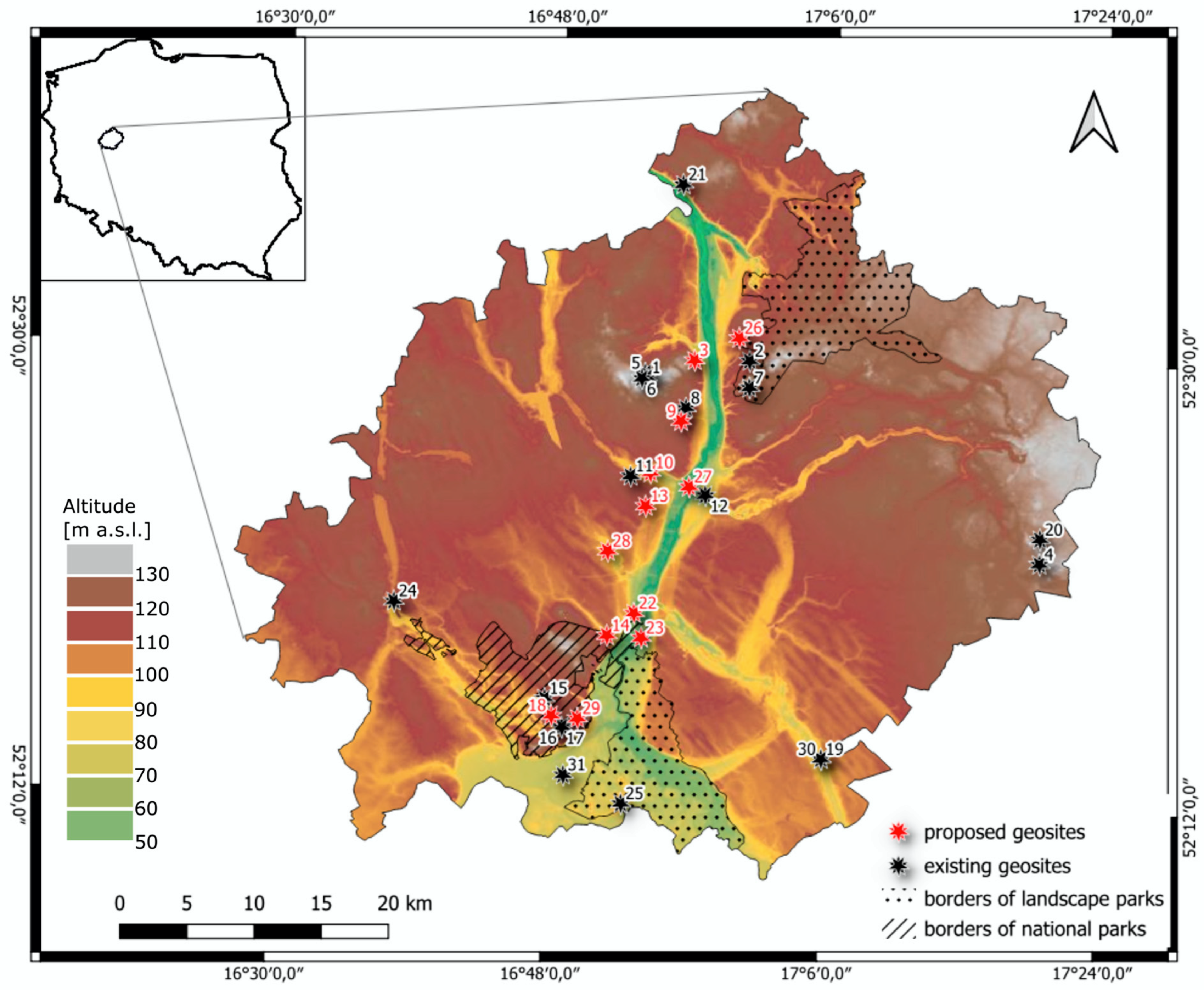
2.3. Study Area—Landscape Diversity in the Region of Poznań (Poland)
3. Results
4. Conclusions
Author Contributions
Funding
Institutional Review Board Statement
Informed Consent Statement
Data Availability Statement
Acknowledgments
Conflicts of Interest
References
- Dowling, R.; Newsome, D. Geotourism. The Tourism of Geology and Landscape; Goodfellow Publishers Ltd.: Oxford, UK, 2010. [Google Scholar]
- Tukiainen, H.; Toivanen, M.; Maliniemi, T. Geodiversity and Biodiversity. In Visages of Geodiversity and Geoheritage; Kubalíková, L., Coratza, P., Pál, M., Zwoliński, Z., Irapta, P.N., van Wyk de Vries, B., Eds.; Geological Society: London, UK, 2022; Volume 530, pp. 31–47. [Google Scholar]
- Rutherford, J.; Newsome, D.; Kobryn, H.T. Interpretation as a Vital Ingredient of Geotourism in Coastal Environments: The Geology of Sea Level Change, Rottnest Island, Western Australia. Tour. Mar. Environ. 2015, 11, 55–72. [Google Scholar] [CrossRef]
- Morante-Carballo, F.; Domínguez-Cuesta, M.J.; Paz-Salas, N.; Malavé-Hernández, J.; Dueñas-Tovar, J.; Carrión-Mero, P. Evaluation of the potential of coastal cliffs as geosites for the promotion of geotourism. Geogr. Sustain. 2023, 4, 356–371. [Google Scholar] [CrossRef]
- Cappadonia, C.; Coratza, P.; Agnesi, V.; Soldati, M. Malta and Sicily Joined by Geoheritage Enhancement and Geotourism within the Framework of Land Management and Development. Geosciences 2018, 8, 253. [Google Scholar] [CrossRef]
- Drinia, H.; Tsipra, T.; Panagiaris, G.; Patsoules, M.; Papantoniou, C.; Magganas, A. Geological Heritage of Syros Island, Cyclades Complex, Greece: An Assessment and Geotourism Perspectives. Geosciences 2021, 11, 138. [Google Scholar] [CrossRef]
- Spyrou, E.; Triantaphyllou, M.V.; Tsourou, T.; Vassilakis, E.; Asimakopoulos, C.; Konsolaki, A.; Markakis, D.; Marketou-Galari, D.; Skentos, A. Assessment of Geological Heritage Sites and Their Significance for Geotouristic Exploitation: The Case of Lefkas, Meganisi, Kefalonia and Ithaki Islands, Ionian Sea, Greece. Geosciences 2022, 12, 55. [Google Scholar] [CrossRef]
- Zangmo, G.; Quesada-Román, A. Geomorphosites inventory in the Eboga Volcano (Cameroon): Contribution for geotourism promotion. Géomorphologie Relief Process. Environ. 2022, 26, 19–33. [Google Scholar]
- Dóniz-Páez, J.; Becerra-Ramírez, R.; Németh, K.; Gosálvez, R.U.; Lahoz, E. Geomorfositios de interés geoturístico del volcán monogenético Tajogaite, erupción de 2021 (La Palma, Islas Canarias, España). Geofísica Int. 2024, 63, 731–748. [Google Scholar] [CrossRef]
- Serrano, E.; González Trueba, J.J. Environmental education and landscape leisure. Geotourist map and geomorphosites in the Picos de Europa National Park. GeoJ. Tour. Geosites 2011, 2, 295–308. [Google Scholar]
- Filocamo, F.; Rosskopf, C.M.; Amato, V.A. Contribution to the Understanding of the Apennine Landscapes: The Potential Role of Molise Geosites. Geoheritage 2019, 11, 1667–1688. [Google Scholar] [CrossRef]
- Rypl, J.; Havlíček, M.; Dostál, I. Geotourism Potential Assessment: A Case Study of the Czech-Austrian cross-border area. Geoheritage 2021, 13, 1. [Google Scholar] [CrossRef]
- Petrović, M.D.; Lukić, D.M.; Radovanović, M.; Vujko, A.; Gajić, T.; Vuković, D. “Urban geosites” as an alternative ge-otourism destination—Evidence from Belgrade. Open Geosci. 2017, 9, 442–456. [Google Scholar] [CrossRef]
- Hernández, W.; Dóniz-Páez, J.; Pérez, N.M. Urban Geotourism in La Palma, Canary Islands, Spain. Land 2022, 11, 1337. [Google Scholar] [CrossRef]
- Salim, E.; Gauchon, C.; Ravanel, L. Seeing the Ice. An Overview of Alpine Glacier Tourism Sites, Between Post- and Hyper-Modernity. J. Alp. Res. 2021, 109. [Google Scholar] [CrossRef]
- Jamorska, I.; Sobiech, M.; Karaskiewicz, T.; Tylmann, K. Geoheritage of Postglacial Areas in Northern Poland—Prospects for Geotourism. Geoheritage 2020, 12, 12. [Google Scholar] [CrossRef]
- Coronato, A.; Schwarz, S.; Flores Barrera, F. Glacial Landforms as Geodiversity Resources for Geotourism in Tierra del Fuego, Argentina. Quaest. Geogr. 2022, 41, 5–24. [Google Scholar] [CrossRef]
- Szczuciński, W.; Muszyński, A. Meteoryty, kratery uderzeniowe i inne ślady kosmicznej katastrofy w rejonie Moraska pod Poznaniem. Przegląd Geol. 2020, 68, 637–644. [Google Scholar]
- Zwoliński, Z.; Jasiewicz, J.; Mazurek, M.; Hildebrandt-Radke, I.; Makohonienko, M. Geohazards and Geomorphologi-cal Setting in Poznań Urban Area, Poland. J. Maps 2021, 17, 202–214. [Google Scholar] [CrossRef]
- Kubalíková, L. Geomorphosite assessment for geotourism purposes. Czech J. Tour. 2013, 2, 80–104. [Google Scholar] [CrossRef]
- Kubalíková, L. Assessing Geotourism Resources on a Local Level: A Case Study from Southern Moravia (Czech Republic). Resources 2019, 8, 150. [Google Scholar] [CrossRef]
- Geostanowiska, Polski Instytut Geologiczny. Available online: https://geologia.pgi.gov.pl/geostanowiska/ (accessed on 30 May 2024).
- Kubalíková, L.; Kirchner, K. Geosite and Geomorphosite Assessment as a Toolfor Geoconservation and Geotourism Purposes: A Case Studyfrom Vizovická vrchovina Highland (Eastern Part of the Czech Republic). Geoheritage 2016, 8, 5–14. [Google Scholar] [CrossRef]
- Kirchner, K.; Kubalíková, L.; Bajer, A. Local geoheritage: Its importance and potential for geoturist and recreational activities (a case study from Lomnicko area). In Proceedings of the Public Recreation and Landscape Protection—With Nature Hand in Hand? Brno, Czech Republic, 1–3 May 2017. [Google Scholar]
- Kubalíková, L.; Kirchner, K.; Bajer, A. Secondary geodiversity and its potential for urban geotourism: A case study from Brno city, Czech Republic. Quaest. Geogr. 2017, 36, 63–73. [Google Scholar] [CrossRef]
- Serrano Cañadas, E.; Gonzáles-Trueba, J.J. Assessment of geomorphosites in natural protected areas: The Picos de Europa National Park (Spain). Géomorphologie Relief Process. Environ. 2005, 1, 197–208. [Google Scholar] [CrossRef]
- Reynard, E.; Fontana, G.; Kozlik, L.; Scapozza, C. A method for assessing the scientific and additional values of geomorphosites. Geogr. Helv. 2007, 62, 148–158. [Google Scholar] [CrossRef]
- Dóniz-Páez, J.; Pérez, N.M. El Hierro Island Global Geopark. Diversity of Volcanic Heritage for Geotourism; Springer: Cham, Switzerland, 2023. [Google Scholar]
- Višnić, T.; Spasojević, B.; Vujičić, M. The Potential for Geotourism Development on the Srem Loess Plateau Based on a Preliminary Geosite Assessment Model (GAM). Geoheritage 2015, 8, 173–180. [Google Scholar] [CrossRef]
- Ewertowski, M.; Rzeszewski, M.; Szuman, I. Zróżnicowanie form i osadów marginalnych fazy poznańskiej ostatniego zlodowacenia w okolicach Poznania—Wyniki wstępnych badań geomorfologicznych. In Przemiany Środowiska Geograficznego Polski Północno-Zachodniej; Kostrzewski, A., Czerniawska, J., Eds.; Bogucki Wydawnictwo Naukowe: Poznań, Poland, 2006; pp. 25–36. [Google Scholar]
- Stankowski, W. Morasko Meteorite. A Curiosity of the Poznań Region; Wydawnictwo Naukowe UAM: Poznań, Poland, 2008. [Google Scholar]
- Zwoliński, Z.; Hildebrandt-Radke, I.; Mazurek, M.; Makohonienko, M. Existing and proposed urban geosites values resulting from geodiversity of Poznań city. Quaest. Geogr. 2017, 36, 125–149. [Google Scholar] [CrossRef]
- Troć, M.; Milecka, K. Wiek osadów aluwialnych doliny Warty oraz doliny Cybiny-Bogdanki w rejonie śródmieścia w Poznaniu. Badania Fizjogr. Ser. A 2008, 59, 145–159. [Google Scholar]
- Bartkowski, T. Rozwój polodowcowej sieci hydrograficznej w Wielkopolsce środkowej. Zesz. Nauk. UAM Geogr. 1957, 1, 3–79. [Google Scholar]
- Dymek, D. Miejskie tereny nadrzeczne rzeki Warty w Poznaniu—Potencjał i ograniczenia. Badania Fizjogr. Ser. A 2014, 65, 113–128. [Google Scholar]
- Rogowski, M. Geopark Morasko jako potencjalny produkt turystyczny. Stud. Perieget. 2015, 1, 215–230. [Google Scholar]
- Witczak, Ł.; Macias, A. Wpływ człowieka na tereny biologicznie czynne w mieście na przykładzie klinów zieleni w Poznaniu. Badania Fizjogr. Ser. A 2016, 67, 271–288. [Google Scholar]
- Mazurek, M.; Abramowicz, D. Środowisko Geograficzne Zlewni Junikowskiego Strumienia; Bogucki Wydawnictwo Naukowe: Poznań, Poland, 2022. [Google Scholar]
- Stępniewska, M.; Sobczak, U. Assessing the synergies and trade-offs between ecosystem services provided by urban floodplains: The case of the Warta River Valley in Poznań, Poland. Land Use Policy 2017, 69, 238–246. [Google Scholar] [CrossRef]
- Wilkaniec, A.; Urbański, P. Twierdza Poznań w krajobrazie na przestrzeni XIX i XX wieku—Od krajobrazu rolniczego po zurbanizowany. Acta Sci. Pol. Adm. Locorum 2010, 9, 147–158. [Google Scholar]
- Abramowicz, D.; Stępniewska, M. Public investment policy as a driver of change in the ecosystem services delivery by an urban green infrastructure. Quaest. Geogr. 2020, 39, 5–18. [Google Scholar] [CrossRef]
- Stryjakiewicz, T.; Kaniecki, A.; Sosiński, P. Zmiany krajobrazu, zagospodarowania przestrzennego i funkcji Ostrowa Tumskiego. In Ostrów Tumski w Poznaniu w Perspektywie Geograficznej; Stryjakiewicz, T., Ed.; Wydawnictwo Naukowe UAM: Poznań, Poland, 2016; pp. 11–32. [Google Scholar]
- Muszyński, A.; Stankowski, W.; Szczuciński, W. Field excursion to the “Morasko Meteorite” Reserve. In Proceedings of the Conference MPSE 2014: Mars—Connecting Planetary Scientists in Europe, Poznań, Poland, 3–5 June 2014. [Google Scholar]
- Stankowski, W. The geology and morphology of the natural reserve “Meteoryt Morasko”. Planet. Space Sci. 2001, 49, 749–753. [Google Scholar] [CrossRef]
- Zwoliński, Z.; Hildebrandt-Radke, I.; Mazurek, M.; Makohonienko, M. Anthropogeomorphological Metamorphosis of an Urban Area in the Postglacial Landscape: A Case Study of Poznań City. In Urban Geo-Morphology; Thornbush, M.J., Allen, C.D., Eds.; Elsevier: Amsterdam, The Netherlands, 2018; pp. 55–77. [Google Scholar]
- Widera, M.; Chomiak, L. Various Genetic Types of End Moraines in the City of Poznań and Its Close Vicinity, Central-Western Poland. Civ. Environ. Eng. Rep. 2019, 29, 218–227. [Google Scholar] [CrossRef]
- Górska-Zabielska, M. Ogródek petrograficzny Wielkopolskiego Parku Narodowego. In Wielkopolski Park Narodowy w Badaniach Przyrodniczych; Walna, B., Kaczmarek, L., Lorenc, M., Dondajewska, R., Eds.; Uniwersytet im. Adama Mickiewicza: Poznań, Poland, 2009; pp. 225–235. [Google Scholar]
- Górska-Zabielska, M. The most valuable erratic boulders in the Wielkopolska region of Western Poland and their potential to promote geotourism. GeoJ. Tour. Geosites 2020, 29, 694–714. [Google Scholar] [CrossRef]
- Dudzińska, A.; Szpakowska, B. Ocena dostępności zieleni dla mieszkańców Poznania—Porównanie stanów z lat 1940 i 2012. Stud. Perieget. 2023, 39, 57–72. [Google Scholar] [CrossRef]
- Raszeja, E.; Gałecka-Drozda, A. Współczesna interpretacja idei poznańskiego systemu zieleni miejskiej w kontekście strategii miasta zrównoważonego. Stud. Miej. 2015, 19, 75–86. [Google Scholar]
- Salee, A.; Rasoolimanesh, M.; Kusumo, C. Tourism Impacts on Destinations: Insights from a Systematic Review of Literature. Asia-Pac. J. Innov. Hosp. Tour. 2022, 11, 121–148. [Google Scholar]
- Garau-Vadell, J.; Díaz-Armas, R.; Gutierrez-Taño, D. Residents’ perceptions of tourism impacts on island destinations: A comparative analysis. Int. J. Tour. Res. 2014, 16, 578–585. [Google Scholar] [CrossRef]

| Dominant Origin | Geosite Number | Geosite | Brief Description |
|---|---|---|---|
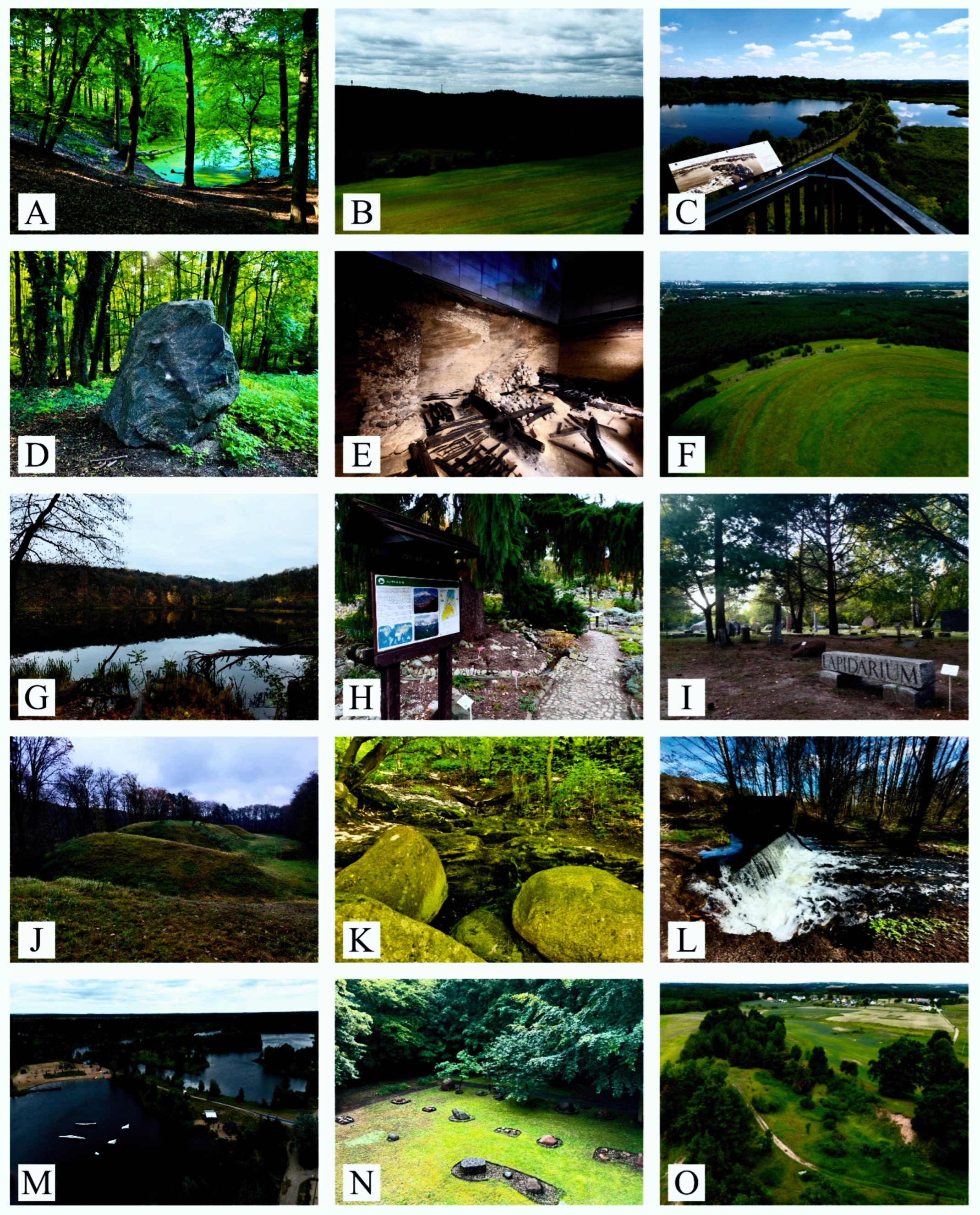
| Meteorite impact | 1 | Morasko Meteorite Reserve * | Six meteorite craters ranging from 20 to 90 m in diameter with a depth of 2 to 11.5 m. The craters are filled with water to form meteorite lakes. |
| Glacial activity | 2 | Exposure of Pleistocene sediments in Annowo * | Artificial exposure of sediments formed in various sedimentary environments, especially glacial and fluvio-glacial. The sediments are sandy formations (especially sands and gravels), as well as sandy clays. |
| 3 | Kokoryczowe Hill | An elevation of moraine character covered with forest, within which there are historical objects—a palace, ruins and a historic cemetery. The hill is built of glacial sands and gravels, with boulders in places. | |
| 4 | Rural Botanical Garden Elżbietówka in Brzeźno * | The site of the occurrence of interesting rocks from the Precambrian. Among them you can see granites, sandstones and gneisses, which are characterized by a peculiar relief of the surface, bearing traces of the corrasion and erosive activity of the ice sheet. | |
| 5 | An erratic boulder in the Morasko Meteorite Reserve * | Gneiss originating from the Precambrian, transported to the Greather Poland region by the ice sheet. The perimeter of the boulder is 6 m, and the weight exceeds 10 tons. | |
| 6 | Morasko Hill * | An example of an elevation—a terminal moraine built of clays, sands and gravels of moraines, largely covered with forest and meadow vegetation. In places, there are lake sediments—sandy silt of drainless depressions. There are meteorite craters within the hill. | |
| 7 | Dziewicza Hill * | An example of an elevation—a moraine built of clays, sands and gravels of moraines, largely covered with forest vegetation. In places there are lake sediments—peats. | |
| 8 | Petrographic lapidarium of the Adam Mickiewicz University in Poznań * | The site of the occurrence of interesting rocks, mainly magmatic rocks formed in the Paleozoic era, including Aland rapakivi, Karlshamn granite and Kalmar sandstone. The erratic boulders bear traces of transport and destructive glacial activity. Within the site, there are examples of utilitarian use of stone. | |
| 9 | Tunnel valley in the Żurawiniec Reserve | A form resulting from glacial activity, now constituting a drainless depression in which a transitional peatland has formed. Wetland area surrounded by forest. | |
| 10 | Bogdanka–Cybina tunnel valley | It is characterized by interesting landforms, the result of glacial activity and its transformation by human activity. The bottom of this tunnel valley is uneven, characterized by slopes, sills and depressions, as well as anthropogenic objects, including water reservoirs. | |
| 11 | Alpinarium at the AMU Botanical Garden | The site of interesting rocks, mainly magmatic rocks formed in the Precambrian and early Paleozoic, including granites, gneisses and sandstone. The largest has a circumference of 12 m. The erratic boulders bear traces of transport and destructive glacial activity. The surface of some boulders shows signs of corrasion. | |
| 12 | The erratic boulders in the Tysiąclecia Park | The site of interesting rocks, mainly volcanic and metamorphic, formed especially in the Precambrian era. Among them are Karlshamn granite, Smaland granites Dalarna sandstone. Transported by the ice sheet during the Pleistocene glaciation. The erratic boulders bear traces of transport and destructive glacial activity, such as visible glacial cracks. | |
| 13 | Alpinarium in Wilson Park | A publicly accessible site for the occurrence of interesting rocks of average and small size, prepared to represent the character of rocks and mountain vegetation. It is located in the center of the historic district of Poznań. | |
| 14 | Wirynka tunnel valley | The tunnel is made of sands and sandy silts, carried by the Wirynka River, which from the village of Wiry to its mouth has developed interesting fluvial forms. There is a small waterfall on the river near Łęczyca. | |
| 15 | Petrographic lapidarium in Jeziory * | Gathered examples of the most common erratic boulders in Greater Poland transported by the ice sheet from northern Europe during the Leyssinian phase of the North-Polish glaciation (20,000 years ago). Among them, you can see basalts, granites, gneisses and sandstones originating mainly from the Precambrian and Paleozoic. | |
| 16 | Bukowsko–Mosiński esker, Szwedzkie Hills * | Esker is built of sands and gravels and is the longest of its kind in Poland. “Swedish Hills” is the final part of it. It is a dike with a base width of up to 100 m and a ridge line of up to 10 m, and its height reaches up to 15 m | |
| 17 | Boulder of Prof. A. Wodziczka * | A granite boulder dating back to the Precambrian. Its circumference is more than 4.5 m. It was brought by the ice sheet from an outcrop in Smaland in southeastern Sweden. | |
| 18 | Lakes of the Górecko–Budzyńska tunnel valley | The tunnel valley is the deepest of the four in the Wielkopolski National Park. It cuts in at a depth of 30 m. The trough was carved by the meltwater of the northern Polish ice sheet during the Leszno phase. | |
| 19 | Tunnel valley of Kórnik–Zaniemyśl lakes * | The subglacial tunnel valley is located within the flat ground moraine. The tunnel was carved out by the meltwater of the North-Polish ice sheet during the Leszno phase. | |
| 20 | Frontal moraine in Brzeźno * | A series of moraines, the form of which is clearly marked in the relief of the area, and its foreland shows a drainage system in the form of shallow valley forms. The moraine is composed of sands, gravels and moraine clay. | |
| Fluvial activity | 21 | Valley in the Śnieżycowy Jar reserve | The moraine upland was developed during the Vistula glaciation. Later, the Poznański Przełom Warty was formed and a very deep valley was cut. Numerous small valley forms developed in the edge of the upland thus formed. |
| 22 | Oxbows lakes Kocie Doły and Kocie Dołki | Oxbows lakes formed as a result of cutting off the river bend of the Warta River. Periodically fed by flowing waters at high levels of the Warta River. | |
| 23 | Paleomeanders and an oxbow lake of the Warta River east of the village of Łęczyca | Paleomeanders are a remnant of the former bends of the Warta River. Together with the oxbow lakes, they constitute an area waterlogged during river floods. The area is also valuable for its plant communities and numerous animal species. | |
| 24 | Żarnowiec Spring * | The only karst spring in Greater Poland. It is characterized by a fairly high yield. The water here flows naturally and spontaneously to the surface at the foot of a 10 m slope of the Bukowsko–Mosiński esker. | |
| 25 | Parabolic dune and paleochannels of the rift river in Żabinko * | The wall of the exploited dune exposure shows sands and gravels with interbeds of silts and peats with plant remains. Paleochannels of the rift river are clearly visible to the east and south of the dune. | |
| Human activity | 26 | Post-mining ponds in Owińska | An example of the recultivation of areas after the end of gravel mining. The layout of the water reservoirs, the presence of dikes and artificially shaped banks testify to historical industrial activity. |
| 27 | Genius Loci and Ostrów Tumski | Exposure of a 10th-century Poznań fortified rampart in the form of a cross-section of layers up to 6 m deep. The cross-section shows the effects of human activity in the river valley over the last 1000 years. | |
| 28 | Post-mining area Szachty | A post-mining area where spontaneous renaturalization occurred after mining activities ended. Numerous water-filled post-mining depressions are present in the area, as well as dikes and steep banks testifying to historical mining activity. | |
| 29 | Post-mining ponds in Pożegowo | A water-filled pit after clay mining, located near the highest elevation of the Wielkopolski National Park—Osowa Góra. | |
| 30 | Conical mound in Bnin * | The bases of the invisible wooden structures of the concave mound lie about 2.5 m below the current level of Lake Bnin, proving its lower level at the time of the mound’s operation, some 2500–2900 years ago. | |
| 31 | Gravel pit Krosno * | The site is located within the latitudinally oriented Obra Proglacial Valley. Within the excavation site there is a significant accumulation of fossil faunal remains from the Late Glacial and Holocene in sandy and gravelly fluvial-glacial and fluvial deposits. |
| Geosite Type | Geosite Number | Integrity | Representativeness | Rareness | Paleogeographical Interest | Total Scientific Values | Ecological | Aesthetical | Cultural | Total Added Values | Protection Status | Threats | Accessibility | Security | Site Context | Tourist Infrastructure | Interpretive Facilities | Educational Interest | Total Use Characteristics | Geosite Score |
|---|---|---|---|---|---|---|---|---|---|---|---|---|---|---|---|---|---|---|---|---|
| Meteorite | 1 | 1 | 1 | 1 | 1 | 1.00 | 1 | 1 | 0.25 | 0.75 | 1 | 0.75 | 1 | 1 | 0 | 0.75 | 0.75 | 1 | 0.78 | 0.84 |
| Glacial | 2 | 0.75 | 0.75 | 0.5 | 1 | 0.75 | 0 | 0.5 | 0 | 0.17 | 0 | 0.5 | 0 | 0.5 | 0 | 0 | 0 | 0.25 | 0.16 | 0.36 |
| 3 | 0.75 | 0.5 | 0.5 | 1 | 0.69 | 0.5 | 0.5 | 1 | 0.67 | 1 | 0.75 | 0.75 | 0.75 | 0 | 0.75 | 0 | 0.25 | 0.53 | 0.63 | |
| 4 | 0.75 | 1 | 0.25 | 1 | 0.75 | 0 | 0.75 | 0 | 0.25 | 0 | 0.75 | 0.5 | 1 | 0 | 0.5 | 0.25 | 0.75 | 0.47 | 0.49 | |
| 5 | 1 | 1 | 0.75 | 1 | 0.94 | 0 | 1 | 0.75 | 0.58 | 1 | 1 | 1 | 1 | 0 | 0.75 | 0.25 | 1 | 0.75 | 0.76 | |
| 6 | 1 | 1 | 0.25 | 1 | 0.81 | 1 | 0.75 | 0.25 | 0.67 | 1 | 0.75 | 1 | 0.5 | 0 | 0.75 | 0 | 0.25 | 0.53 | 0.67 | |
| 7 | 1 | 1 | 0.25 | 1 | 0.81 | 1 | 1 | 1 | 1.00 | 1 | 0.75 | 1 | 0.5 | 0 | 1 | 0.5 | 1 | 0.72 | 0.84 | |
| 8 | 1 | 1 | 0.75 | 1 | 0.94 | 0 | 0 | 1 | 0.33 | 1 | 1 | 0.75 | 1 | 0 | 0.25 | 0.5 | 1 | 0.69 | 0.65 | |
| 9 | 0.75 | 1 | 0.5 | 0.5 | 0.69 | 1 | 0.5 | 0.5 | 0.67 | 1 | 0.25 | 0.75 | 1 | 0 | 0.5 | 0.25 | 0.25 | 0.50 | 0.62 | |
| 10 | 0.5 | 0.75 | 0.5 | 0.75 | 0.63 | 1 | 0.75 | 0.75 | 0.83 | 1 | 0.5 | 1 | 0.75 | 0 | 1 | 0.25 | 1 | 0.69 | 0.72 | |
| 11 | 1 | 0.75 | 0.75 | 1 | 0.88 | 0 | 1 | 0.5 | 0.50 | 1 | 1 | 0.75 | 1 | 0 | 0.75 | 0.25 | 0.75 | 0.69 | 0.69 | |
| 12 | 0.75 | 1 | 0.75 | 1 | 0.88 | 0 | 0.25 | 0.75 | 0.33 | 0 | 0.75 | 1 | 1 | 0 | 0.5 | 0.25 | 0.25 | 0.47 | 0.56 | |
| 13 | 0.5 | 0 | 0.5 | 0.25 | 0.31 | 0 | 1 | 0.5 | 0.50 | 0 | 0.5 | 1 | 1 | 0 | 0.75 | 0 | 0.25 | 0.44 | 0.42 | |
| 14 | 1 | 0.75 | 0.75 | 0.75 | 0.81 | 1 | 0.5 | 0.25 | 0.58 | 1 | 0.75 | 0.5 | 0.5 | 0 | 0.25 | 0 | 0.25 | 0.41 | 0.60 | |
| 15 | 0.5 | 1 | 0.25 | 1 | 0.69 | 0 | 0.5 | 0 | 0.17 | 1 | 1 | 0.5 | 1 | 0 | 1 | 0.25 | 1 | 0.72 | 0.52 | |
| 16 | 0.75 | 1 | 0.25 | 1 | 0.75 | 0.25 | 0.75 | 0.5 | 0.50 | 1 | 1 | 0.5 | 1 | 0 | 0.75 | 0.25 | 1 | 0.69 | 0.65 | |
| 17 | 1 | 1 | 0.25 | 0.75 | 0.75 | 0 | 0.5 | 0 | 0.17 | 1 | 1 | 0.5 | 1 | 0 | 0.75 | 0.25 | 0.75 | 0.66 | 0.52 | |
| 18 | 0.75 | 0.75 | 0.75 | 1 | 0.81 | 1 | 0.75 | 0.25 | 0.67 | 1 | 0.5 | 0.5 | 0.75 | 0 | 0.75 | 0.25 | 1 | 0.59 | 0.69 | |
| 19 | 0.75 | 1 | 0.75 | 1 | 0.88 | 1 | 0.75 | 0 | 0.58 | 1 | 0.75 | 1 | 0.75 | 0.25 | 1 | 0.25 | 0.75 | 0.72 | 0.73 | |
| 20 | 0.75 | 1 | 0.5 | 0.75 | 0.75 | 0.25 | 0.25 | 0 | 0.17 | 0 | 0.75 | 0.5 | 1 | 0 | 0 | 0 | 0.5 | 0.34 | 0.42 | |
| Fluvial | 21 | 0.75 | 0.75 | 0.5 | 1 | 0.75 | 1 | 0.5 | 0.25 | 0.58 | 1 | 0.75 | 0.5 | 0.75 | 0 | 0.5 | 0.25 | 0.5 | 0.53 | 0.62 |
| 22 | 0.5 | 0.5 | 0.25 | 0.5 | 0.44 | 0.75 | 0.75 | 0 | 0.50 | 0 | 0.25 | 1 | 0.75 | 0.25 | 0.5 | 0.25 | 0.25 | 0.41 | 0.45 | |
| 23 | 1 | 0.75 | 0.25 | 0.75 | 0.69 | 1 | 0.5 | 0.75 | 0.75 | 1 | 1 | 0.5 | 1 | 0 | 0.5 | 0.25 | 1 | 0.66 | 0.70 | |
| 24 | 1 | 1 | 1 | 0.75 | 0.94 | 0 | 0.75 | 0 | 0.25 | 1 | 1 | 0.5 | 1 | 0 | 0.75 | 0.25 | 0.75 | 0.66 | 0.61 | |
| 25 | 0.5 | 1 | 0.75 | 1 | 0.81 | 0 | 0 | 0 | 0.00 | 0 | 0.25 | 0.5 | 0 | 1 | 0 | 0 | 1 | 0.34 | 0.39 | |
| Anthropogenic | 26 | 0.5 | 0.75 | 0.5 | 0 | 0.44 | 0.25 | 1 | 1 | 0.75 | 0 | 0.5 | 0.75 | 0.5 | 0.25 | 1 | 0.5 | 0.75 | 0.53 | 0.57 |
| 27 | 0.5 | 1 | 1 | 1 | 0.88 | 0 | 1 | 1 | 0.67 | 0 | 0.75 | 1 | 1 | 0 | 0.75 | 0.75 | 1 | 0.66 | 0.73 | |
| 28 | 0.5 | 1 | 0.75 | 0.5 | 0.69 | 1 | 1 | 1 | 1.00 | 0 | 0.5 | 1 | 0.75 | 0.25 | 0.5 | 0.75 | 1 | 0.59 | 0.76 | |
| 29 | 0.75 | 0.5 | 0.5 | 0.25 | 0.50 | 0.75 | 0.75 | 0.5 | 0.67 | 0 | 0.5 | 0.5 | 0.75 | 0.25 | 0.75 | 0.25 | 0.25 | 0.41 | 0.52 | |
| 30 | 0.5 | 1 | 0.75 | 0.5 | 0.69 | 0 | 0.5 | 1 | 0.50 | 0 | 1 | 0.5 | 1 | 0 | 0.25 | 0.25 | 1 | 0.50 | 0.56 | |
| 31 | 0.25 | 1 | 1 | 1 | 0.81 | 0 | 0 | 0 | 0.00 | 0 | 0.25 | 0.5 | 0 | 1 | 0 | 0 | 0.5 | 0.28 | 0.36 | |
| Average | 0.74 | 0.85 | 0.58 | 0.81 | 0.75 | 0.44 | 0.61 | 0.44 | 0.50 | 0.52 | 0.7 | 0.7 | 0.79 | 0.1 | 0.59 | 0.26 | 0.69 | 0.54 | 0.60 | |
| Geosite | Number | Type | Score |
|---|---|---|---|
| Morasko Meteorite Reserve * | 1 | Meteorite | 0.84 |
| Dziewicza Hill * | 7 | Glacial | 0.84 |
| Post-mining area Szachty | 28 | Anthropogenic | 0.76 |
| An erratic boulder in the Morasko Meteorite Reserve * | 5 | Glacial | 0.76 |
| Genius Loci and Ostrów Tumski | 27 | Anthropogenic | 0.73 |
| Tunnel valley of Kórnik–Zaniemyśl lakes * | 19 | Glacial | 0.73 |
| Bogdanka–Cybina tunnel valley | 10 | Glacial | 0.72 |
| Paleomeanders and an oxbow lake of the Warta River east of the village of Łęczyca | 23 | Fluvial | 0.70 |
| Lakes of the Górecko–Budzyńska tunnel valley | 18 | Glacial | 0.69 |
| Alpinarium at the AMU Botanical Garden | 11 | Glacial | 0.69 |
| Morasko Hill * | 6 | Glacial | 0.67 |
| Petrographic lapidarium of the Adam Mickiewicz University in Poznań * | 8 | Glacial | 0.65 |
| Bukowsko-Mosiński esker, Szwedzkie Hills * | 16 | Glacial | 0.65 |
| Kokoryczowe Hill | 3 | Glacial | 0.63 |
| Valley in the Śnieżycowy Jar reserve | 21 | Fluvial | 0.62 |
| Tunnel valley in the Żurawiniec Reserve | 9 | Glacial | 0.62 |
| Żarnowiec Spring * | 24 | Fluvial | 0.61 |
| Wirynka tunnel valley | 14 | Glacial | 0.60 |
| Post-mining ponds in Owińska | 26 | Anthropogenic | 0.57 |
| Conical mound in Bnin * | 30 | Anthropogenic | 0.56 |
| Positive Factors | Negative Factors | |
|---|---|---|
| Internal factors | Strengths
| Weaknessess
|
| External factors | Opportunities
| Threats
|
Disclaimer/Publisher’s Note: The statements, opinions and data contained in all publications are solely those of the individual author(s) and contributor(s) and not of MDPI and/or the editor(s). MDPI and/or the editor(s) disclaim responsibility for any injury to people or property resulting from any ideas, methods, instructions or products referred to in the content. |
© 2024 by the authors. Licensee MDPI, Basel, Switzerland. This article is an open access article distributed under the terms and conditions of the Creative Commons Attribution (CC BY) license (https://creativecommons.org/licenses/by/4.0/).
Share and Cite
Abramowicz, D.; Tritt, R. Between Meteorite, Glacier and Rivers—Towards Geotourism Development in Diverse Landscape. Sustainability 2024, 16, 8119. https://doi.org/10.3390/su16188119
Abramowicz D, Tritt R. Between Meteorite, Glacier and Rivers—Towards Geotourism Development in Diverse Landscape. Sustainability. 2024; 16(18):8119. https://doi.org/10.3390/su16188119
Chicago/Turabian StyleAbramowicz, Dawid, and Remigiusz Tritt. 2024. "Between Meteorite, Glacier and Rivers—Towards Geotourism Development in Diverse Landscape" Sustainability 16, no. 18: 8119. https://doi.org/10.3390/su16188119
APA StyleAbramowicz, D., & Tritt, R. (2024). Between Meteorite, Glacier and Rivers—Towards Geotourism Development in Diverse Landscape. Sustainability, 16(18), 8119. https://doi.org/10.3390/su16188119