1. Introduction
The themes of climate-adaptive design through nature-based solutions (NbS) and green or blue infrastructure have been extensively explored concerning urban regeneration at different scales in recent years. This approach involves a conscious and ethically responsible strategy for planning and design, emphasizing principles of recovery, reuse, and recycling within a framework of city–nature regeneration [
1].
Within this frame, and reflecting on the role of streets and citizens in transforming cities and re-appropriating collective spaces (from the early reflections by Jane Jacobs’ works) [
2], this paper aims to also consider the new implications of recent and urgent transitions. Streetscapes are, in fact, a physical and mental trace that fosters encounters and exchanges. They are places of trans-activities where dwelling adheres to its founding contract of coexistence, and where the reality of living is experienced, and solutions for reconciling interior and exterior spaces are worked out in a tangible context and present time. Moreover, streets and their streetscapes reconnect suburbs and marginalized, degraded areas to the urban body, therefore re-appropriating the trajectory on which to base urban regeneration as a permanent laboratory for ecological transition.
Urban regeneration is, therefore, a culture that must be disseminated through experimental research-action planning. For this reason, through a system of conscious and ethically responsible design actions of “doing-by-thinking-and-creating”, we rely on the idea of city–nature at various scales of intervention [
1]. In doing so, we challenge the contemporary notion of cities that reflect the “age of technical reproducibility”, which has now reached its crisis peak [
3]. This never-ending city is, in fact, characterized by a disconnection from the land, as well as disappearing community spaces, fewer livable areas, the loss of cultural heritage and natural renewal, together with a decline in rich cultural interactions.
However, on the other hand, many transformation processes today open up the possibility of new projects, often because of traumatic events such as reconstruction after a catastrophe or the need to recover disused or abandoned places. Nevertheless, crises can constitute crucial opportunities for the regeneration of the contemporary city, emerging phenomenologically from the constructive themes of intervention in urbanized areas. Furthermore, through the lens of the green city model [
4], the nature-based regeneration of streetscapes has been investigated from various perspectives and disciplinary fields. Among them, we reckon that in the past 20 years, there has been a growing interest in infrastructural space regeneration from a design-oriented perspective, aiming to reduce stormwater runoff [
5] and improve air quality. The widespread and varied nature of infrastructural systems presents opportunities for rebalancing the unequal distribution of green open spaces. This approach focuses on improving the quality of spaces where people spend significant amounts of time each day. This interest raises questions about how nature-based designs of streetscapes can contribute to creating more sustainable environments [
6,
7]. Johansson [
8] emphasizes the importance of integrating sustainable streetscape designs at the local level through nature-based solutions (NbS). Implementing NbS for the green regeneration of urban infrastructures offers numerous benefits, including economic, social, and ecological advantages, while simultaneously enhancing the quality of public spaces and aiding cities in adapting to climate change. However, it also addresses challenges and concerns, highlighted by Raffa [
9], regarding the climate-resilient, nature-based regeneration of streetscapes from a design perspective.
The present contribution, which is supported by two pieces of EU-funded research, aims to advance design research and mainstream design-driven climate-adaptive nature-based regeneration of streetscapes. By doing so, the paper explores the implications of these themes and their interconnectedness through the different aspects and roles of design. Thus, supporting the transformation of collective street spaces into multifunctional, climate-adaptive nature-based streetscapes would contribute to addressing both global and local challenges related to climate, environment, and society.
By examining the relationships among these crucial themes, we aim to answer the main research question: How can the green regeneration of infrastructural spaces be leveraged from a design perspective to create climate-adaptive, nature-based streetscapes?
2. State of the Art
To explore the current state of the art concerning the interplay between climate adaptation and nature-based regeneration of streetscapes from a spatial design perspective, a comprehensive literature review was conducted using Scopus and Google Scholar databases, as well as open-source reports from international organizations and city authority planning documents.
Within this context, Urban experimentations have demonstrated that the multiple benefits provided by Nature-based solutions (NbS) design and implementation can contribute significantly to addressing climate, environmental, social, and economic justice in the city. Nature-based solutions, according to one of its most recent definitions, are conceived as «actions to protect, conserve, restore, sustainably use and manage natural or modified ecosystems […] which address social, economic and environmental challenges effectively and adaptively, while simultaneously providing human well-being, ecosystem services and resilience and biodiversity benefits [
10].
In climate-adaptive pioneering cities, monofunctional, car-centric, and anonymous roadways have already been redesigned through the implementation of NbS, transforming them into new commons that enhance slow mobility and create spaces for social interactions. It is, for example, the case of the New York City Greenstreet program (developed in 1996)—today part of the City’s green infrastructure [
11]—where green regeneration urban initiatives have evolved and multiplied, embracing new challenges, such as climate change. Similarly, the city of Boston has continued its efforts, resulting in the elaboration, among others, of the Urban Forest Plan [
12] from its first report, Climate Ready [
13].
In this case, natural mechanisms are re-elaborated to address environmental, social, ecological, and economic challenges, turning streets into performative, multifunctional spaces [
14,
15,
16] that improve urban biodiversity [
17] and well-being while connecting people with nature through public spaces.
Moreover, the concept of urban regeneration, which has evolved over the past 30 years, is characterized by its flexibility and capacity to address global urban challenges [
18]. Reformulating the definitions provided by Paul Hawken [
19] and Roberts [
20], urban regeneration is conceived here as an integrative and comprehensive approach to addressing the climate crisis. It intertwines justice, climate resilience, biodiversity, and human well-being through spatial strategies and actions, therefore opening pathways to sustainable development. According to UN-Habitat (2023), “Urban regeneration brings back underutilized assets and redistributes opportunities, increasing urban prosperity and quality of life. […] urban regeneration ensures affordability, access to services and involvement of local residents to promote local economic development, […] [enhance] public space […] [as] a key element of interventions, and […] reduce environmental impact and GHG emissions” [
21]. Streetscapes are among the most underutilized and accessible public resources in cities [
22]. The concept of streetscapes encompasses “the natural and built fabric of the street and is defined by the design quality of the street and its visual effect. It includes buildings, the street surface, and the fixtures and fittings that facilitate its use” [
23], as well as its socio-ecological dynamics. Recently, alongside the evolution of urban regeneration as a means to create more climate-resilient, just, and inclusive urban environments, streetscapes have been recognized as hotspots for climate change inequality [
24]. However, due to their pervasive presence within the urban fabric [
25], they also present opportunities to simultaneously address climate change effects, local inequalities, and their complex interconnections, therefore enhancing well-being and spatial quality.
2.1. Addressing Climate and Nature-Related Issue through Design Framework
The research conducted through Scopus and Google Scholar has identified a wide variety of results referring to different knowledge fields. While searching for (design) framework, the majority of identified contributions develop design frameworks and guidelines through an analytical-comparative approach [
26] across case studies or through experimental design [
27] in specific cities and/or street typologies or by combining both methods. For instance, Cabanek et al. [
28] developed a biophilic design framework for the green regeneration of streets via nature-based solutions, applying it to four prototypical street sections in the EU, US, and Australia. Similarly, Klemm et al. [
29] formulated design guidelines for urban green infrastructure aimed at climate adaptation, working at the city, park, and neighborhood street levels through a mixed-method analysis that integrates micrometeorology and landscape architecture procedures. Furchtlener et al. [
30], within a landscape design-led multidisciplinary research project, provided qualitative-quantitative guidelines for transforming Vienna’s streets into sustainable, climate-resilient elements of the city’s green infrastructure. Additionally, Tamminga et al. [
31] argued that “convivial green streets” could be a source of climate adaptation. They extracted Nature-based solutions and devices from ten European case studies, implemented them in specific street sections, generalized them according to typological criteria, and translated them into simple visualizations to support future community engagement activities. Another significant group of studies focused on experimental design processes and outputs that, despite their specificity, hold general value. For example, Lotfata et al. [
32] employed a research-through-design methodology to test the feasibility of nature-based solutions in various street sections within an informal neighborhood in Cairo. Furthermore, Moscatelli & Raffa [
33] explored the interconnections between neighborhood streetscape green regeneration, energy transition, and climate change through nature-based solutions design in arid climates using design-driven research. Hagen et al. [
34], within an interdisciplinary project and through a living lab approach, introduced processes and actions for the co-design of greener and climate-adaptive regeneration of streetscapes in a dense neighborhood in Vienna. Through a collaborative process, replicable design solutions were developed, and tactical urbanism actions were implemented to raise awareness among residents. This body of research underscores the importance of integrating Nature-based solutions into streetscape design to address climate, environmental, social, and economic challenges effectively. The varied methodologies and interdisciplinary approaches highlighted in these studies provide valuable insights for the development of climate-adaptive nature-based streetscape design methodologies and tools, but more design research is needed. Investigation among city authority planning documents and reports has been conducted. In particular, two have been critical for the purpose of this research.
The first experience, regarding the Los Angeles street network, has been developed by an interdisciplinary consortium, the Urban Forest Equity Collective (UFEC), which has landscape firm STOSS Landscape Urbanism among its consultants. The efforts of UFEC resulted in the LA Urban Forest Equity Street Guidebook [
35] and other documents that address specific LA neighborhoods. Streets are envisioned as spaces of possibility to tackle climate change and the structural asymmetric distribution of green spaces which affects especially the most vulnerable neighborhood. Recognizing that each street, neighborhood, and community in Los Angeles embodies a unique set of social, economic, environmental, ecological, and infrastructural dynamics, the guidebook built up a multilevel and multitemporal model able to provide a straightforward and adaptable framework for prioritizing interventions and devising a street-space reforestation and NbS implementation strategy which encompass both the neighborhood and the city scale. This strategic document also addresses the challenge of operationalizing urban forests and ensuring effective and sustainable implementation at the neighborhood level. The UEFC developed a framework that includes practical tools to prioritize and plan for increased green spaces and nature-based solutions (NbS) in urban areas. It provides decision-making support, strategies for community engagement, and visions for neighborhoods in Los Angeles, illustrating a compelling and feasible path toward a greener future. This framework follows a three-tiered approach [
36]: implementation of green spaces and tree canopy within the streetscape is categorized into three levels of intervention—low, medium, and high intensity.
The second example is New Space For Living: Design Guidelines for Public Spaces [
37], developed by the landscape architecture firm Felixx for the City of Groningen in the Netherlands. This guideline employs a typological approach to deconstruct the urban infrastructural system. Nature-based solutions are strategically integrated to enhance spatial quality, tailored to the specific conditions and constraints of streetscapes, and visualized through cross-sectional perspectives. The urban transformations of streetscapes are then assessed based on a comprehensive set of 10 criteria, including mobility, safety, accessibility, health, social aspects, economic impact, experiential qualities, ecological considerations, climate adaptation strategies, and local identity. These evaluations are conducted both before and after proposed implementations, presented through scenario-based cross-sections, and structured around a phased design methodology. The guidelines conclude by synthesizing and testing street solutions within three distinct neighborhoods in Groningen, demonstrating a nuanced, context-specific approach to addressing urban complexity.
Compared to other fields, design discipline research has made relatively modest contributions to the topic. Among scientific research co-authored by multidisciplinary teams, design disciplines are notably less frequent. This has led to lower spatial quality in visualizations accompanying experimental studies, which tend to prioritize the implementation and performance evaluation of Nature-based solutions over their spatial implications. In addition to our primary objective of the literature review, other considerations have emerged that have shaped the current research. First, there are geographical asymmetries. Certain urban contexts, particularly in the US and Northern and Central Europe, are leading in addressing contemporary challenges by recognizing the urban significance of infrastructural spaces to strengthen green infrastructure and enhance the city’s adaptive capacity. These regions are advancing in design research and urban experiments aimed at revitalizing infrastructural spaces into dynamic and adaptive streetscapes through the implementation of Nature-based solutions (NbS). However, design research and implementation efforts in Southern Europe and Mediterranean urban areas remain limited. Nevertheless, especially in the Spanish peninsula, it is possible to recognize noticeable efforts to embrace climate adaptation strategies and tackle the challenges posed by climate change. For example, Barcelona has developed its Green Infrastructure and Biodiversity Plan [
38], which later supported the climate emergency action plan for 2030 [
39], promoting solutions such as green corridors and expanding urban green spaces through the Superblock model [
40] to enhance ecological resilience and mitigate heat island effects, through streets and public spaces regeneration. As well as Barcelona, cities like Valencia and Madrid, but also Lisbon and Porto, are developing planning tools and adaptation plans to integrate climate adaptation with different layers of infrastructure, and develop urban solutions. However, only a few studies and urban experiments focusing on these geographical, climatic, and socio-cultural contexts have been developed, although the Mediterranean region has already experienced significant impacts from climate change extremes and stresses. Second, there is a disparity in the size of urban environments. While large urban areas worldwide are pioneering climate-adaptive nature-based regeneration, medium and small-sized cities and urban environments often face structural gaps that prevent them from capitalizing on the potential benefits of transforming infrastructural spaces into climate-adaptive nature-based streetscapes.
2.2. Problematic Framework and Research Questions
From the literature review, three main issues are evident. First, the spatial implication of nature-based regeneration of infrastructural spaces is significantly underestimated in current urban climate adaptation and green infrastructure strategies and actions. Second, the role of design research in climate-adaptive nature-based regeneration of infrastructural spaces remains inadequately explored within current predominantly functionalist and sectoral practices. This research hypothesizes that a transdisciplinary approach involving architecture and design-related disciplines could address the complexity of this issue and offer innovative solutions, therefore enhancing space quality and urban livability. However, there is insufficient knowledge regarding design principles and methodologies to effectively operationalize the regenerative potential of climate-adaptive nature-based infrastructural regeneration. Thirdly, while design research has limited impact on innovating current practices, it can guide and influence practice through a continuous learning process. Bridging the gap between design research and practical implementation is crucial, particularly in geographical contexts and urban environments where such initiatives are lacking. There is a critical need to connect design research with real-world outcomes, using experimental design studies as a pivotal link between theoretical insights and effective urban transformations. Design, as a transformative discipline, employs methods and tools that can foster stakeholder awareness, understanding, and consensus-building.
Within this framework, the following research questions arise:
How can green regeneration of infrastructural spaces be leveraged from a design perspective to create climate-adaptive nature-based streetscapes?
What design methodologies and tools can be employed to activate the potential of streetscapes at the neighborhood level, supporting climate adaptation in medium and small cities while enhancing their green infrastructure?
How can these approaches be effectively applied within a Mediterranean, specifically Southern Italian, urban context?
3. Methodology of the Research
Through the definition of a research methodology capable of merging different fields, types, and scales of knowledge, it is possible to balance design and research processes, exploring the potentialities of both and defining their limits. In dealing with the uncertainty of climate-adaptive processes and other complex environmental challenges, it is crucial to support and focus on a reflexive approach with multiple feedback loops, as well as strive for an answer that can no longer be certain [
41]. Thus, through the comparison of methodological approaches that look for a relation between theory and practice, research and design, such as the one developed by Frayling [
42], Hauberg [
43], and Schreurs [
44,
45], a three-phase methodology has been elaborated, aiming at merging research and design through a replicable and informed way. The proposed methodology is divided into (1) Research about design, (2) Research by or through design, and (3) Research for design. The first phase, which aims to define rules and procedures, examines models and similar studies and, as intended by Findeli [
46], documents objects, phenomena, and the history of design so as to contribute to a scientific discipline through (its) design [
47]. The second phase, which introduces two different points of view, explores how design, in its different forms and meanings, is shaped to produce a new level of shared knowledge. With this object in mind, a Research-through-Design (RtD) approach means to relate to material-based research, development works, and action research, through practical experiments in laboratories, resulting in reports [
43] targeted for societal change [
48,
49,
50]. In addition, RtD supports a (artifact) design process based on trial and error to better tackle complex design problems [
51]. Alternatively, the point of view that this research would adopt is mainly related to the Research by design, where “concordance is sought between the methods of research and a form-giving, experimental design practice” [
43]: this approach, in fact, produces knowledge through the design’s tool and methods, in a direct relationship between analyzing and proposing solutions. Finally, the Research-by-design phase develops complex design proposals where the previously acquired knowledge is embodied in the artifact [
52].
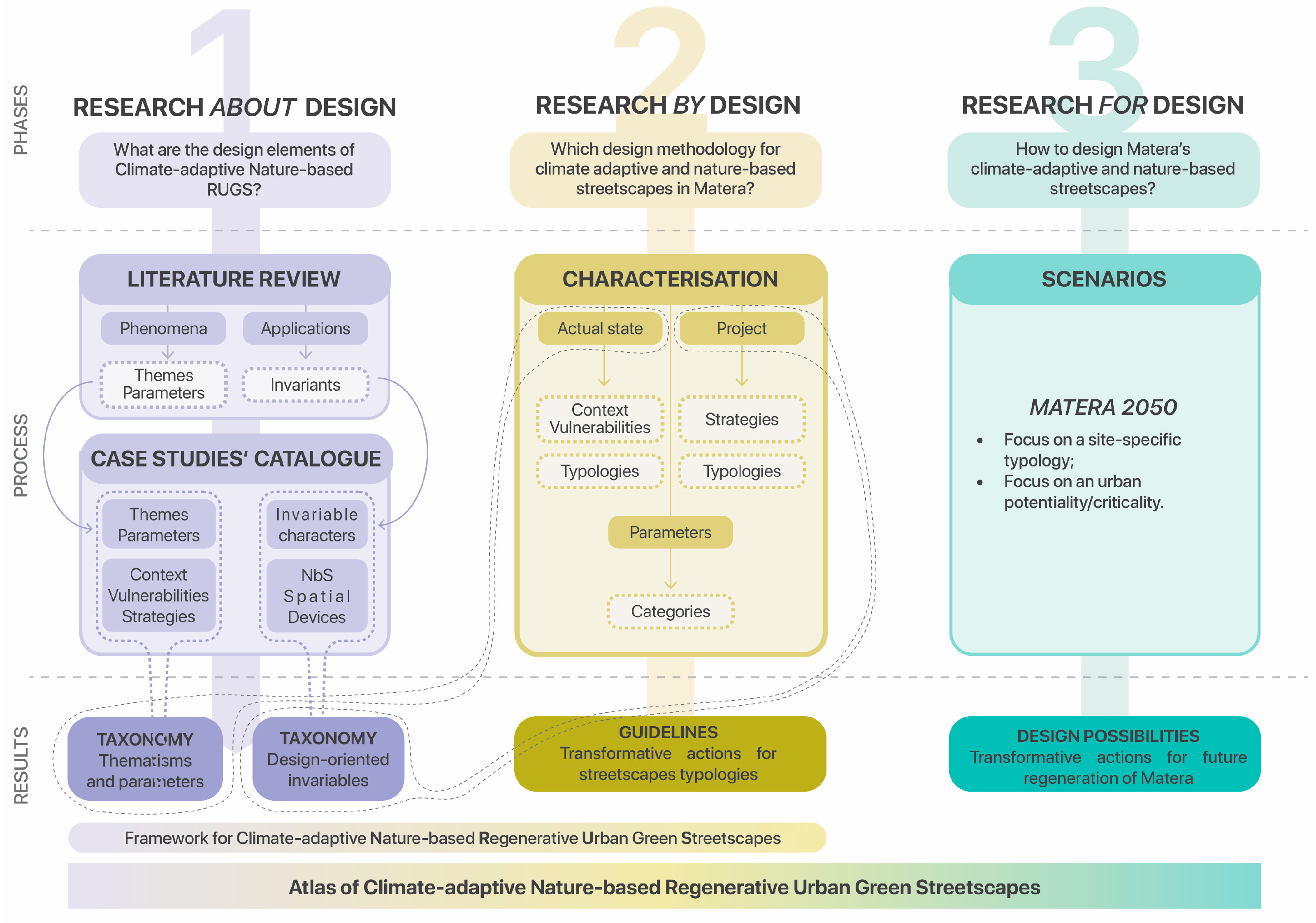
Based on this structure, the research discussed here is structured into these three phases, each one exploring a section of the research question and informing and verifying the others in a continuous feedback loop (
Figure 1).
The first phase of “Research about Design” combines two separate moments of (a) literature review and (b) case study catalog and analysis. Through the characterization of the specific but multidisciplinary literature review, which explores similar research that has investigated the theme of climate-adaptive streetscapes from a design-driven perspective, this phase defines themes, parameters, and invariant design character. They will then be explored more in-depth through the selected case studies, aiming at developing different levels of knowledge, from the general context information to the specific design-oriented characterization. The projects inform and verify the literature review’s results in a continuous feedback loop. Finally, the Research about Design phase would result in the elaboration of two taxonomies: (1) related to the recurrent themes of the investigated approach and (2) focused on the invariant peculiarity of the architectural project.
The results of the first part would then inform the second phase of Research by Design to resonate on the possibility of defining the characterization of streetscapes specifically for the application case of the city of Matera. In this phase, design and research will be highly interconnected to produce knowledge through the design itself, thus generating desirable, perhaps unexpected, urban perspectives in place of probable but less desirable urban developments [
53]. The second phase would then be divided into a first section of research on the actual context, which would be analyzed and described through its specific features. A second section would then elaborate a focus point on the city through a typological study of the urban built environment. Through a process that indicates vulnerabilities and defines transformative strategies, some neighborhoods of the city would be explored through their streetscape typology, and climate-adaptive and nature-based design solutions would be suggested. The goal of this phase would then be the elaboration of Design Guidelines for supporting the urban transformation of urban streetscapes.
By intertwining the Research about and by Design phases, it would be possible to elaborate a framework for climate-adaptive nature-based Regenerative Urban Green Streetscapes (R.U.G.S), supporting both conceptual and operational insight for the development of future streetscapes.
Finally, the guidelines will inform and be verified by the third phase of “Research for Design”, which aims to explore urban transformation scenarios for the future of Matera, answering site-specific vulnerabilities through a design-driven approach projected to the near future.
In the following paragraphs, the paper will discuss in more detail the first phase of the methodology through ongoing insights into the research, focusing on its role in contributing to the definition of the design framework.
3.1. Research about Design: The Structure
The selected projects are then analyzed through a process divided into two sections (
Figure 2):
Section 1 “Analyze”: Analysis of the selected projects through three phases;
Section 2 “Comparison”: Comparison between the selected projects through three phases.
The first section, “Analyze”, relates to the first level of understanding and decomposition of the cases and is divided into:
Part 1, “Context”, delves into the contextual analysis of the projects, focusing on climatic, social, economic, and infrastructural aspects. This phase also points to the vulnerability the projects aim to solve and the corresponding strategies put in place;
Part 2, “Design procedures”, delves into the specific climate-adaptive strategies and Nature-based solutions implemented in the projects, assessing their role in the design process and their impact on the site’s social, environmental, and economic dimensions.
Part 3, “Design principles”, explores the invariant design characters of each project.
This initial phase of analysis leads then to the second section, “Comparison”, in which the projects are progressively put in relation to each other. Following a structure similar to
Section 1, a three-part comparison is developed:
Part 1, “Context”, compares contextual information about the projects to point out initial insight about the relationship between geographical and climatic placement;
Part 2, “Design procedures”, shows the frequency and the specificity of the nature-based solutions recognizable in the project involved.
Part 3, “Design principles”, compares the frequency and specificity of the invariant design characters to point out the most common elements that fuel climate-adaptive and nature-based projects for the streetscape.
3.2. Themes and Parameters
From the analysis and comparison of frameworks and guidelines designed in scientific papers, reports, and documents from cities at the forefront of street climate-adaptive and nature-based regeneration, a set of themes and associated parameters has been defined (
Table 1). In the first phase of the research, themes and parameters are used in the analysis of case studies to evaluate how the climate-adaptive nature-based regenerative strategies cope with existing vulnerabilities. They were also used in the second phase of the research and in the experimental design experiences for characterizing the streetscape, between present vulnerabilities and future opportunities.
3.3. Selecting the Case Studies
Within the frame of the research methodology and through the analysis of the selected case studies, a catalog of climate-adaptive nature-based projects is developed. The catalog aims to provide design-oriented insights that could support informed, future-proof adaptive projects. The selected projects of the catalog all respond to a specific list of requirements that contextualize them according to matters of scale, time, space, and peculiarities. In the multitude of projects, built or designed, which are explicitly facing climatic issues through a legitimating lens of nature-related solutions, the catalog explores those with a strong design-driven process, which put in practice a multilevel and multi-scalar approach to face multiple issues. Lastly, all the selected projects have drawn attention to the adoption of NbS, contributing, therefore, to climatic, environmental, social, and economic benefits (
Table 2).
The selection criteria are divided into three parts: (a) general, (b) scale, and (c) design features. The first section, “General”, describes the geographical, chronological, and specialistic characteristics of the project: it should be in countries that have explored climate adaptation for a long time through spatial design, referring thus mostly to Northern European countries. Also, the selected project should provide strong and impactful urban or landscape spatial transformation design, designed or realized since the 2000s, so that the relation to climate change and climate emergency could be explicit.
The second category of criteria concerns the concept of scale and refers to two sub-categories, (d) system and place, (e) which host four criteria: (d1) territorial, (d2) urban, (e1) neighborhood, and (e2) public space. At different scales, these criteria require the project to be involved or to have an active role in the activation of regenerative processes based on climate-adaptive strategies, which could then include and involve different actors and strategies. At the territorial scale, it is required that the project be developed in places that have adopted (climate-adaptive) urban planning frameworks or where local regulations addressing climate adaptation for Green and Blue Infrastructures are followed. If such a context is provided, the project will engage regenerative (urban) transformation by addressing climate adaptation through the lens of equitable design. Therefore, the project would have a spatial impact also at the neighborhood scale, soliciting, at the same time, community engagement and social awareness of the topic of climate-adaptive policies. Finally, the project would relate to the neighborhood’s collective, shared (public) spaces, which have the potential to define a network of Green and Blue Infrastructure by enhancing ecological, social, and economic entanglements with the surroundings.
Lastly, the third section concerns descriptive design features, such as (f) status and (g) site, indicating that the project could be investigated in different phases (built, under construction, tender, design proposal, masterplan, research output, etc.) and would involve an abandoned, underused or degraded urban space or infrastructure. Furthermore, it includes the presence of (h) NbSs as a necessary condition to pursue ecological, social, and economic regeneration through spatial transformation.
3.4. Comparing the Case Studies
The catalog of projects that feeds and informs the framework includes projects related to different scales and specific geographies, which explore the theme of urban regeneration through climate-adaptive and nature-based solutions. By collecting and analyzing these exemplary case studies, we aim to identify design principles and procedures that facilitate the integration of climate resilience considerations into streetscape regenerative processes.
The research has so far collected around 60 projects, 40 of which are here shown and compared, taking into account their contextual positioning (as can be seen in
Table 3 and
Table 4) and the recurrency and specificity of the nature-based solutions involved (as it can be seen in
Figure 3 and
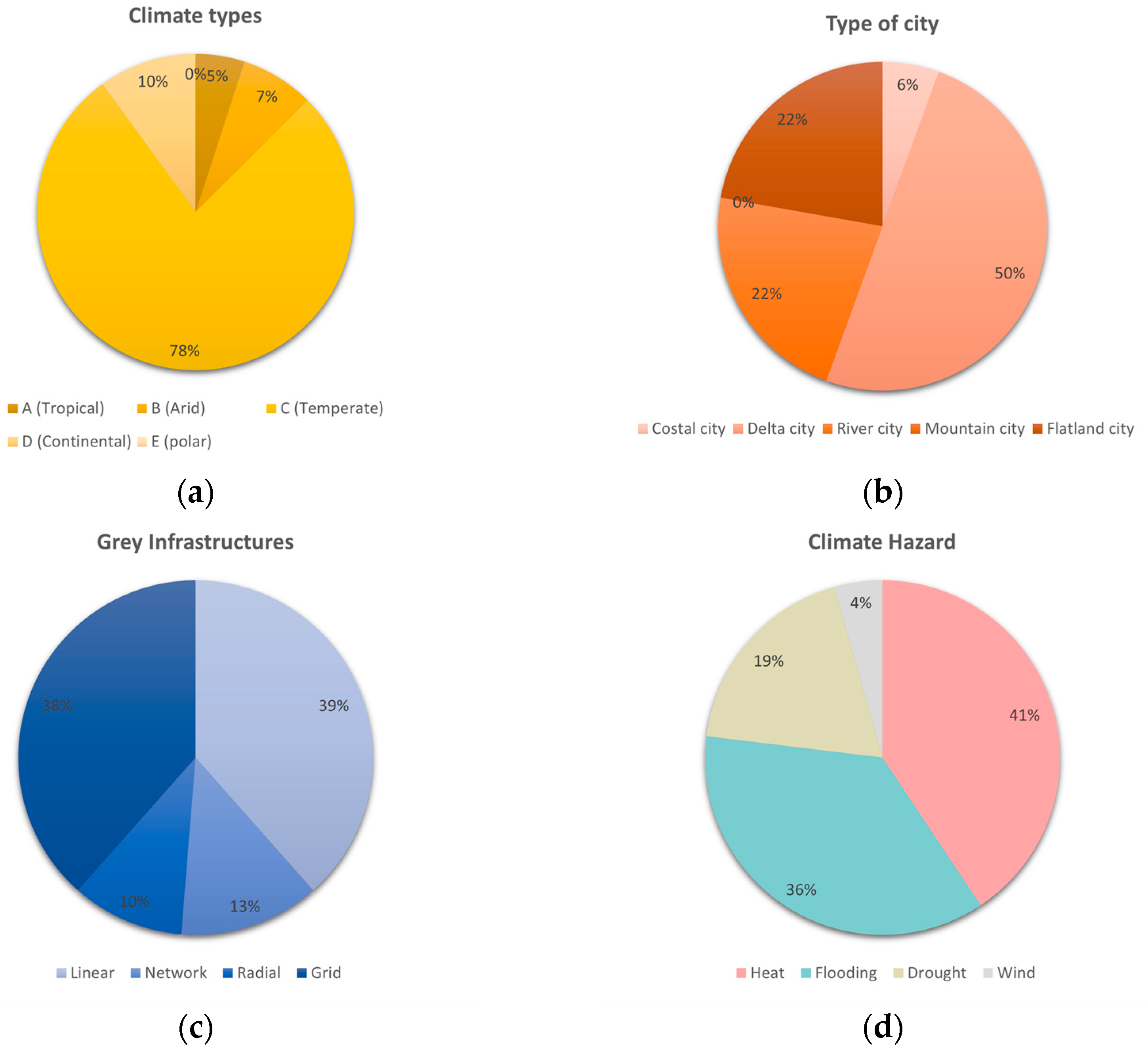
Figure 4). Related to geographical areas chosen in the selection phase and referred to the US and Northern Europe, these projects highlight their transformation potential by dealing with climate hazards, mainly with heat stress and flooding in different types of gray infrastructures, regardless of the climatic types or morphology.
It can be noticed, in fact, that while only two cases refer to the climatic type (according to the Koppen classification) A (tropical), three to the type B (arid), four cases refer to the type D (continental), and the majority of them (31) refers to the type C (temperate), there is an inhomogeneous predisposition of the project in dealing with the same climatic hazards. In fact, six cases are related to only one climatic hazard, 20 cases to two climatic hazards, 11 to three climatic hazards, and three to four climatic hazards, where heating and flooding are predominant. The reason for this diversity can be related to the heterogeneity of the gray infrastructures they explore or even to the type of cities analyzed (see
Figure 3a–d). In fact, from the comparisons of the two tables, we can observe that (1) 15 cases refer to the linear [L] type, six cases refer to the network [N] type, four cases refer to the radial type [R], and 14 cases refer to the grid [G] type; (2) six cases refer to the coastal [C] type of city, 12 cases refer to the delta [D] type of city, 15 cases refer to the river [R] type of city, zero cases refer to the mountain [M] type of city, seven cases refer to the flatland [F] type of city.
At the same time, the research has compared the type and frequency of Nature-based solutions in the selected projects (
Figure 4 and
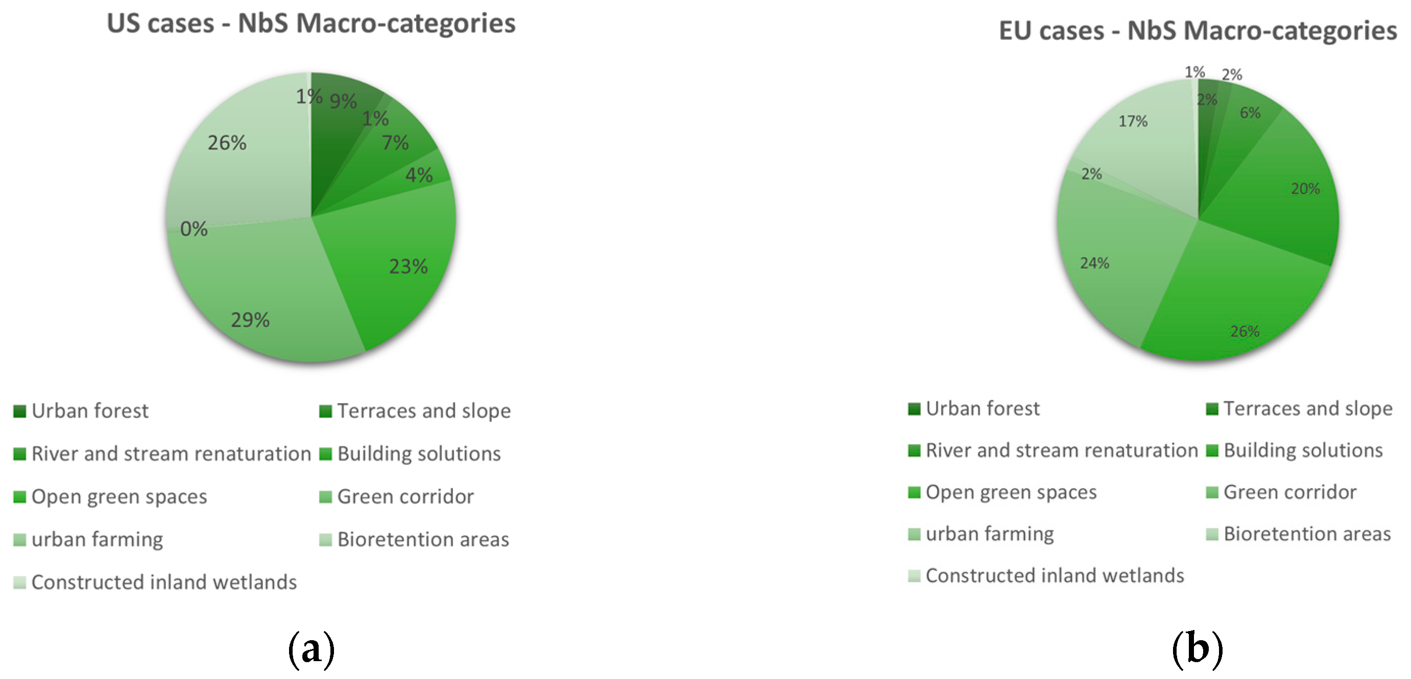
Figure 5) to highlight similarities and differences in their approach to urban regeneration. The comparison uses the classification of NbS developed by the design studio Felixx together with the World Bank (2021) [
54], which divides the NbSs into macro-categories (or Families) and Categories (or Technologies). Among the ones considered, we can observe that there is not a sole dominant Macro-category: in the US cases, green corridors and bioretention areas prevail (with 29% and 26% frequency), while in the EU case, open green spaces and green corridors (with 26% and 24%). In addition, there is a large use of NbSs related to retention areas in the US cases, up to 26%, while the EU cases show a large interest in building solutions, up to 20% (
Figure 6a,b). Therefore, a distinctive focus can be observed in the detailed methodologies and specific NbS applications. US projects, with their emphasis on multifunctional urban spaces and extensive use of green infrastructure, aim for broader community engagement and environmental resilience. In contrast, European projects often prioritize water management and ecological connectivity, adapting urban environments to their unique regional needs and challenges. The selected project, thus, reflects a growing trend toward reimagining urban landscapes to address contemporary environmental challenges while enhancing the quality of life for urban residents.
4. Application
For a cultural and academic institution as a university to initiate a research-action process it means to develop and share knowledge packages to the whole society and territory. Within this frame, “FareStrada” is the name for the urban action research unit conceived at the University of Basilicata for the construction of an international network of studies within the research lab of NatureCityLAB (DiCEM, University of Basilicata, founded by Armando Sichenze in 2000). Our work explores the concept of the nature-city, focusing on the ecological transformation of cities through the regeneration of streetscapes. The many projects developed in the years aim at defining a narrative representation that shifts the center of the action from the city to the urban landscape. Although located in different geographies, these projects highlight the core idea of a composition of site-specific designs, as in the case of the project developed for the municipality of Guanzhou (in collaboration with A. Sichenze in 2009–2010), where the attention is drawn to the livability of the streetscapes. This nature-city project in Guangzhou integrates various infrastructures, including narrative ones, and aims to create regenerative textures that reflect the city’s multifaceted identity, balancing new developments and renovations. In other projects by NatureCityLAB, the relationship between Requalification and Regeneration is crucial. For instance, the GreenWay of Potenza (by A. Sichenze and I. Macaione, 2008–2009) envisions a system of reconnecting green areas, transforming the city into a park that promotes urban regeneration and values nature-city concepts (
Figure 7). Another example is Alétheia-Forenza (by A. Sichenze in 2002–2005), a masterplan applying ecological conversion models to rural village streetscapes. In Matera, a feasibility study was conducted for the creation of the Demoetnoantropological Museum Park for the Sasso Caveoso [
55]; moreover, the GreenWay for Tricarico (Mt), Milo torrent valley’s environmental restoration and valorization project, and later Altamura, Sannicandro, and Santeramo (by I. Macaione 2020–2023), the design interventions aim to regain a space of shared interests as well as new connections between public and private dimensions. In this way, the design contributes to finding a new system of opportunities, completeness, skills, and answers related to a whole urban intervention strategy. Moreover, these design occasions allow the exploration of the territories through the lens of nature, focusing on the 10 fundamental city conditions of domesticity, naturality, insularity, centrality, topicity, coexistentiality, temporality, initiality, landscapes, and representativeness [
56,
57]. These conditions of phenomenic appearance of what makes the city great, define the recognizable connecting richness as an urban quality factor, showing the opportunities that climate-adaptive nature-based streetscapes regeneration can open.
In more recent times, in fact, NatureCityLAB has embraced these contemporary design themes, developing a methodology for the research and application of good practices to urban landscapes, benefitting from emblematic design experiences worldwide. The two experiences of Piccianello and Martella introduced here—the modern expansion of the center area of the city of Matera—fit into this framework and contribute to its development. They exploit the aforementioned design and research methodology but delve into the research-driven design and research-by-design phases in different ways. In fact, in Piccianello, the lack of green spaces and climate change adaptation is addressed from an equity perspective, integrating data-driven methodologies and community outreach to go beyond socio-ecological vulnerabilities. On the other hand, the area of La Martella develops typological research of the streetscape of the suburban district, with the scope of defining climate-adaptive and nature-based transformation operational insights.
5. Climate-Adaptive, Equitable, and Nature-Based Streetscape: A Design-Driven Experiment in the Vulnerable Neighborhood of Piccianello
Piccianello, one of Matera’s historical neighborhoods, lies on the outskirts of the ancient Sassi area. It encompasses neighborhoods with diverse characteristics, including the first modern residential complex (1935) and the Spine Bianche neighborhood (1965), recognized by urban and architectonic critics as a model of modern social housing in Italy. The neighborhood’s urban fabric reflects the impacts of contemporary urban deregulation and recent low-quality expansions. As the northern gateway to Matera, Piccianello houses significant urban services and exhibits a multifaceted streetscape marked by ecological, social, and economic vulnerabilities, which are likely to be exacerbated by climate change. The critical nature of this neighborhood makes it an ideal subject for experimental urban resilience methodologies. The design-based experience has an experimental value and aims to verify and refine principles and test procedures that have emerged in the previous research phases. It has been conceived as a two-year urban living lab that will elaborate on a design methodology that, in the future, will contribute to informing the Matera climate-adaptive, equitable, regenerative streetscape guidelines. The design-driven research has been organized into three complementary phases: neighborhood analysis, streetscape characterization, and co-design. Although the scope of this experimentation is design-oriented, it has assumed as critical a trans-disciplinarity approach to knowledge; different expertise from landscape architecture, environmental and climate science, social sciences, hydraulic engineering, and agronomy had been integrated, and local knowledge.
5.1. Neighborhood-Scale Analysis and Priority Areas
This comprehensive approach allowed for a detailed mapping of climatic and socio-ecological vulnerabilities, inequalities, and adaptation opportunities with a focus on infrastructural spaces for the whole neighborhood. A landscape-based layer methodology decomposed Piccianello’s complexity and made it more approachable (
Figure 8), facilitating the integration of diverse data sources and analytical frameworks. Layers have been later recomposed to provide a detailed assessment of the neighborhood’s asymmetries, needs, and opportunities and support the prioritization of areas.
Climatic and Socio-Ecological Vulnerabilities: Current climate conditions, including temperature variations and precipitation patterns, were spatially represented. Future climate scenarios, particularly concerning heat stress and drought, were projected using climatological models, enabling proactive planning and intervention strategies. These data were spatialized using geographic information systems (GIS), facilitating the identification of high-risk areas and prioritization of interventions. Multiple layers represented different aspects of vulnerabilities, including areas susceptible to extreme heat and drought, and socio-economic disparities. Vulnerable populations such as low-income households, elderly residents, and children were also mapped. Tree canopy cover in relation to socio-economic and environmental factors was assessed, identifying areas with low canopy cover and high need for greening, guiding the implementation of green infrastructure and nature-based solutions (NbS).
Adaptation Opportunities: In addition to pinpointing vulnerabilities, the analysis identified areas ripe for adaptation and improvement. This included mapping green spaces, underutilized areas, and existing infrastructure that could be optimized to enhance climate resilience. The aim was to strike a balance between addressing immediate needs and planning for long-term resilience. In particular, the analysis focused on existing green spaces, underutilized spaces, and gray infrastructures. (i) Existing green spaces were assessed for their current ecological benefits and potential for enhancement. The analysis looked at how these areas could be expanded or improved with additional vegetation, water-management features, and recreational facilities to serve as vital cooling zones and social hubs during extreme heat events. (ii) Underutilized spaces, such as vacant lots and derelict spaces, were identified as prime candidates for redevelopment. These spaces present opportunities to introduce new green infrastructure and nature-based solutions that can contribute to urban cooling, stormwater management, and community cohesion. Transforming these areas can also help alleviate social inequalities by providing new amenities and improving the overall quality of life for residents. (iii) Existing Infrastructure: The assessment included a detailed examination of existing infrastructure, such as roads, sidewalks, and public buildings, to determine how they could be retrofitted or repurposed to support climate resilience.
Streetscape Network Characterization: Parallel to the vulnerability and opportunity mapping, the neighborhood’s streetscape network was classified based on typological criteria. The streetscape network was classified through a typological approach: (i) Residential streets: Typically characterized by lower traffic volumes and a higher proportion of pedestrian activities, offering more space for potential green interventions; (ii) Commercial corridors: These areas face unique challenges due to higher footfall and business activities, necessitating a balance between green infrastructure and commercial use; (iii) Arterial roads: Major thoroughfares that require specific strategies to manage high traffic volumes while enhancing green cover and resilience; (iv) Mixed-use streets: These streets serve various functions and require adaptable solutions to accommodate diverse activities.
Prioritization areas inside the neighborhood informed by the comprehensive analysis of vulnerabilities and opportunities, specific areas within Piccianello were prioritized for intervention. This prioritization was based on a combination of climatic, socio-ecological, and infrastructural layers to ensure that resources were directed towards the areas of greatest need and potential impact.
5.2. Proximity Scale Analysis and Critical Streetscape Selection
The first neighborhood of Piccianello, built in 1935, is among the most social-ecological and climatic vulnerable areas. This area also houses a network of residential, commercial, and mixed-used streets recurrent inside the entire neighborhood, as well as underutilized spaces and micro-green areas. Here also, flooding phenomena and drought-period effects are visible much more than in other areas. Around this modern neighborhood, an urban-regeneration process will occur in the future and offer possibilities to become the first climate-proof neighborhood of Matera. Its streetscape had been further analyzed at a scale of greater proximity, which also facilitates community engagement and empowerment during the whole process, ensuring the process and the foreseen interventions would effectively address local vulnerabilities and promote equitable outcomes. The analytical framework at the local scale encompasses the following steps: (i) Vulnerability assessment: Streetscapes were assessed for their vulnerability to climate impacts such as heat stress and flooding; (ii) Equity considerations: Green equity consideration analysis was conducted at a more proximity scale, also evaluating green space health; (iii) Community input: Insights gathered through community meetings, workshops, and surveys provided critical qualitative data on local priorities, concerns, and aspirations. This participatory approach ensured that choices aligned with community needs and preferences, fostering a sense of ownership and engagement among residents; (iv) Functional analysis: Functional considerations, including pedestrian and vehicular traffic patterns, were integrated into the process. The aim was to optimize the usability and accessibility of streetscapes while enhancing their environmental performance and aesthetic appeal; (v) Physical and morphological characteristics. Each streetscape was evaluated from a morphological perspective, considering factors such as street width, building density, existing green infrastructure, constraints, and opportunities for integration. This detailed assessment guided the design of tailored interventions that harmonized with the neighborhood’s built environment; (vi) Streetscape transect analysis and generative section. Transect analysis was employed to provide a comprehensive, cross-sectional understanding of the urban landscape of the neighborhood. This methodological tool helped identify and address climatic and socio-ecological vulnerabilities, inequalities, and opportunities through a spatial lens. Among the different sections through which the neighborhood streetscape was analyzed, some of them were selected and became the generative section on which the co-design phase was carried.
5.3. Co-Desing Process for Streetscapes Transformation
Co-design approach. Themes and parameters of climate-adaptive nature-based RUGS were used to evaluate generative sections and propose possible design solutions coherent with local opportunities and constraints. They were also used to qualitatively measure streetscape improvements before and after the design outcomes. For each streetscape, three optional design diagrams incorporating nature-based solutions (NbS) were elaborated for each generative section and verified through iterative workshop activities with residents. The work conducted with local residents was also an opportunity to spread knowledge about the benefits of the implementation of nature-based solutions, shed light and/or change people’s perception of these techniques and choose them in a context-sensitive way. The co-design approach allowed for the progressive refinement of shared solutions, ensuring that the final design was well-rounded and comprehensive. Each section also presents additional layers for understanding the foreseen transformation: (i) Design actions and nature-based spatial solutions: Specific design actions that incorporate NbS spatial solutions were defined; (ii) NbS families and techniques, process and benefits: according to the Felixx classification [
54] different NbS families and techniques were identified. This classification helped in selecting appropriate NbS for each context, ensuring that the solutions were effective and feasible. The possible processes and benefits derived from implementing these solutions were also highlighted (
Figure 9).
Three-tier method and implementation phases: Each section was conceived to integrate the three-tier method [
35,
58,
59]. This method involves breaking down the intervention into different phases of implementation based on their complexity and economic feasibility, and different levels of community participation. Actions were categorized into: (i) Immediate actions: Simple, cost-effective measures that can be implemented quickly to provide immediate benefits and with the support of the local community in order to empower them and create a sense of belonging; (ii) Intermediate actions: More complex interventions that require moderate investment and time to implement; (iii) Long-term actions: Projects that may require significant investment and time but offer substantial long-term benefits. This phased approach not only helps manage financial and logistical constraints but also accommodates uncertainties in the design process. By anticipating and allowing for shifting conditions that could impact the project in the future, the design remains flexible and adaptive. The co-design approach, combined with the three-tier method, ensures that the proposed streetscape transformations are both visionary and practical. By integrating community feedback and expert knowledge, the final designs are more likely to succeed and endure. The process enhances ecological connectivity, improves adaptive capacity, and promotes social equity and inclusivity. Moreover, the emphasis on NbS supports biodiversity and fosters a healthier, more resilient urban environment.
6. Climate-Adaptive and Nature-Based Streetscape Typology for La Martella
La Martella is an exemplary emblematic suburban post-war settlement, located around 7 km far from Matera and built between 1952 and 1954 to experiment with new architectural typologies and define a new idea of community-based process. Initiated after the relocation law for the inhabitants of the Sassi district in Matera and in continuity with the land reform program for the South of Italy, the new village was built upon the idea of creating a shared community for peasants, as suggested by Adriano Olivetti, promoter of territorial planning based on the model of the pre-war American experiences [
60,
61]. Adriano Olivetti was at the time president of INU (Istituto Nazionale di Urbanistica, National Institut of Urbanism) and vice-president of the U.N.R.R.A. Casas committee (United Relief and Rehabilitation Administration—Comitato Amministrativo Soccorso Senza Tetto). He benefitted from his experience of research in the United States and tried to apply a North American model derived from the experiences of the New Deal, developed, in particular, with the Tennessee Valley Authority in Norris Town [
6]. He was then also the coordinator of the Committee for the Study of the City and the Countryside of Matera (Commissione per lo Studio della Città e dell’Agro di Matera) to examine different aspects of the physical and social organization of the Sassi and to develop guidelines for new housing projects on the outskirts of Matera [
7].
The first plan for La Martella village was designed by the Italian architect Ettore Stella, replaced after his death by a group of architects related to the Centro Studi per l’Abitazione, led by architect Ludovico Quaroni (together with, among the others, Federico Gorio, Luigi Agati, P.M. Lugli, and Michele Valori). The project explored a closer relationship between the built and the natural environment, with the settlement following the orography of the site, re-interpreting, as far as possible, the local vernacular idea of housing. Therefore, the urban layout puts the collective services at the core of the hill, with the dominant church, the civic center, and the houses arranged along the streets that follow the orography of the place, resulting in a rich articulation of the neighborhood spaces.
The original plan, which was not entirely completed (on the contrary, lots of inhabitants squatted in pertinent spaces behind the houses, which were originally meant for cultivation [
6]), was later integrated with two new residential complex districts, separately designed and built in the 1990s, namely the Ecopolis and the Europan areas. Furthermore, connected by only a rural road on the northern side of the village, an industrial area of about 300 hectares was built between the 1970s and the 1990s, mainly connected to the other industrial areas of the city (PAIP 1 and PAIP 2).
6.1. Vulnerabilities and Potentialities
Today, La Martella is meant as the ensemble of the suburban neighborhood district and the industrial area, showing a high level of abandonment of the common spaces and a progressive degrowth of the population since 2019. In fact, as from the latest ISTAT (Istituto Nazionale di Statistica, the National Statistical Institute) census of 2021, the population of La Martella has 59,748 inhabitants, with a decrease of 1.1% compared to 2019. Up to 2019, and since 1951, the local population has always grown, from 30,390 inhabitants in 1951 to 60,530 in 2019 [
62]. Moreover, placed as part of the Bradano catchment and bordered by the Gravina stream, in the proximity of the Natural Reserve and Lake San Giuliano, the area suffers from episodes of runoff toward the southeast to the Gravina stream, in the occasion of heavy but short-term rains. These vulnerabilities, together with social, economic, and climatic ones, amplify the necessity for a regeneration strategy for the neighborhood, investing in both the residential and the industrial areas, exploring and deepening the potentialities of the spatial transformation of RUGS through a climate-adaptive and nature-based approach of the pilot site of La Martella. As the result of two distinct-development processes, the two areas present a wide variety of streets and built tissues, some referring to a grid type (as in the industrial part) or a network one (as in the residential areas), as in
Figure 10. Following the research-by-design phase, the initial vulnerabilities and types of the actual state would highlight the possibility for a regeneration project, which focuses on the potentialities of the streetscapes as crucial places for urban regeneration. Furthermore, this pilot case benefits from a trans-disciplinarity approach to knowledge, thanks to the close collaboration with different expertise from landscape architecture, climate science, social sciences, hydraulic engineering, and agronomy.
6.2. Understanding the Geographical and Urban Context
By defining the streetscape typology, we aim then to develop a transformative strategy that would take into account the site-specific characteristics of the places, together with the social, environmental, climatic, and economic implications of adopting nature-based solutions as a design tool for regeneration. This characterization phase would thus define design guidelines to develop a wide-range strategic plan for the entire area. Finally, in the research-for-design phase, a detailed transformative scenario would be developed, by exploring and deepening site-specific solutions. Streetscape types are defined based on the sequence of elements that constitute the cross-section, e.g., fences, sidewalks, private-roads, traffic islands, and so on. In addition, types could also be defined by the width of the elements, which is usually related to the type of street considered. Following this structure, we have defined a 13-streetscape typology (
Figure 11), thus analyzed by their plan, cross-section, and three-dimensional aspects (
Figure 12).
7. Discussions
The experimentation conducted in the modern neighborhoods of Piccianello and La Martella illustrates a step further towards developing a climate-adaptive, nature-based streetscape design-led methodology that will inform future guidelines for Matera’s modern and contemporary neighborhoods. The design-driven experiments provide critical insights into the spatial implications of climate-adaptive, nature-based streetscape regenerative design. While the objective is common, the two case studies address different urban conditions. Piccianello is an urban expansion of the historic city, while La Martella was designed as a suburban settlement detached from the city center. This choice makes it possible to approach the streetscape-regeneration complexity within the modern expansions of the city with a good degree of approximation. This discussion focuses on the methodological-operational outcomes of these experiments, comparing their logic and the “designedly way of knowing”. Both design experimentations share a common goal for climate-adaptive nature-based regeneration and a propensity towards transdisciplinary, multi-methods integration and phased implementations. They diverge in their approaches, methodologies, and contextual considerations. Concerning the methodological focus, Piccianello emphasizes a participatory, iterative design process that actively involves the community in shaping the streetscape transformations. Through workshops, surveys, and feedback loops, residents contribute to the design, ensuring that solutions are contextually relevant and aligned with local preferences. This iterative approach allows for continuous refinement based on community input. In contrast, La Martella’s methodology is more focused on detailed typological and morphological analyses. Like in the Felixx framework for Groningen [
37], this approach involves defining specific streetscape typologies, assessing their spatial and functional characteristics, and developing tailored interventions that harmonize with the existing urban fabric. Furthermore, the approaches displayed in Piccianello and La Martella reflect their distinct urban contexts. Piccianello, characterized by its diverse and vulnerable socio-ecological landscape, integrates immediate and long-term interventions to address pressing needs while enhancing overall resilience. The focus is on localizing solutions and improving social equity alongside environmental outcomes, translating and adapting the UFEC design methodology for vulnerable neighborhoods in Los Angeles [
35]. La Martella, with its mix of residential and industrial areas, employs a more detailed analysis of the streetscape typology and urban morphology. This approach addresses the specific characteristics of its built environment to develop context-sensitive streetscape-regeneration strategies. Concerning spatial analysis, Piccianello integrates geographic information systems multi-layered spatial analysis with local knowledge, mapping at different scales climatic and socio-ecological vulnerabilities to prioritize interventions. This approach provides a comprehensive understanding of high-risk areas and supports targeted actions. In contrast, La Martella’s spatial analysis is more focused on defining and evaluating the streetscape types, considering elements like street width, building density, and existing green infrastructure. This typological and three-dimensional analysis aids in creating scalable solutions that are adaptable to various urban contexts.
8. Results
From the comparative analysis of the two design experiments, we can define some operational principles and procedures that could inform future research advancements for Matera’s modern neighborhood streetscapes and aim to impact the city’s public space design and planning in the future.
(a) Transdisciplinary integration. The integration of various disciplines, such as urban planning, landscape architecture, environmental and social sciences, and infrastructural and hydrological engineering, is crucial. However, this integration can also lead to misaligned objectives if not managed properly. Developing a standardized framework for interdisciplinary collaboration, including integrated tools and common terminologies, can enhance coherence and streamline the process. This structured approach to transdisciplinary integration is rarely seen in everyday design practices, where misaligned objectives often hinder effective collaboration. This framework’s novelty lies in its potential to unify diverse expertise into a cohesive strategy, facilitating more effective design and implementation processes.
(b) Comprehensive spatial analysis. Utilizing geographic information systems (GIS) and other spatial tools to map climatic and socio-ecological vulnerabilities is essential. In particular, tree canopy cover in relation to socio-economic and environmental factors has been analyzed. Comprehensive spatial analysis allows for the identification of high-risk areas and the prioritization of interventions, ensuring that resources are directed towards the areas of greatest need and potential impact. This level of detailed, multi-layered spatial analysis is often not applied in everyday design and planning practices, which typically focus on more isolated or less integrated data sets. This method helps in creating a resilient urban environment that can better withstand the effects of climate change.
(c) Typological and three-dimensional analysis. Defining streetscape typologies based on cross-sectional elements and conducting three-dimensional analyses are vital for ensuring spatial coherence and integration into the urban landscape. This approach sustains the replicability of the solutions adopted. By understanding the physical and morphological characteristics of each streetscape, tailored interventions can be designed to harmonize with the existing urban fabric, enhancing both functionality and aesthetics. Such detailed typological and three-dimensional analyses are often overlooked in everyday design processes, which may not focus on spatial quality; their integration also aims to facilitate the replicability and adaptability of solutions to different urban contexts.
(d) Participatory co-design. Engaging local communities throughout the design process is crucial for gathering qualitative data on spatial vulnerabilities, priorities, and preferences, but also to raise awareness of streetscape-regeneration opportunities. Iterative feedback loops allow for the refinement of spatial designs based on community input, fostering a sense of ownership and ensuring that the interventions align with local needs. Participatory co-design not only empowers residents but also enhances the effectiveness and acceptance of the implemented solutions. This approach helps bridge the gap between technical expertise and local knowledge, resulting in more context-sensitive and sustainable outcomes. In Matera, such a deep, iterative engagement is rarely implemented in everyday design practices, where community involvement is often limited to initial consultation phases. It was not applied in the design and planning activities for adaptation and for the streetscapes.
(e) Scenario planning. Incorporating scenario planning allows for the envisioning of multiple possible futures, which can be discussed and refined through the iterative co-design process. Scenario planning helps anticipate and prepare for a range of potential outcomes, ensuring that the design is flexible and adaptable. By considering various scenarios, designers can develop robust strategies that remain effective under different conditions, enhancing the resilience of the urban environment. This forward-thinking approach is essential for addressing the uncertainties associated with climate change and urban development. Everyday design practices in Matera to date lack this forward-thinking approach, focusing more on current conditions without extensively planning for multiple future scenarios.
(f) Phased implementation. Adopting a phased approach to spatial interventions, categorizing actions into immediate, intermediate, and long-term phases, ensures flexibility and adaptability in the design process. The three-tier approach allows for incremental improvements, addressing urgent needs while also laying the groundwork for long-term resilience. This method helps manage financial and logistical constraints, ensuring that the design remains feasible and sustainable over time. Phased implementation also allows for continuous monitoring and adjustment, improving the effectiveness and longevity of the interventions. The novelty lies in the structured, incremental improvements that address urgent needs while laying the groundwork for long-term resilience, which is currently lacking.
(g) Balancing immediate needs with long-term goals. Immediate needs often take precedence over long-term planning, potentially leading to short-term solutions that may not align with strategic resilience goals. Integrating a clear prioritization of actions that align short-term interventions with long-term goals is essential. This balance ensures that immediate challenges are addressed without compromising the overall vision for a resilient and sustainable urban environment. By aligning short-term actions with long-term objectives, the interventions can achieve both immediate benefits and enduring resilience. Such alignment of short-term actions with long-term objectives is lacking in everyday design and planning practices, which focus more on immediate solutions without a strategic long-term vision.
(h) Scalability and transferability. Solutions tailored for one neighborhood may not be directly applicable to other neighborhoods or cities with different socio-ecological contexts. The uniqueness of each urban area requires customized analysis and solutions. Developing adaptable frameworks that allow for local customization can improve scalability. Conducting pilot projects in diverse settings can help refine and validate the methodology’s transferability. This approach ensures that the solutions can be effectively applied in various contexts, enhancing their overall impact and sustainability. The innovative aspect is the emphasis on developing solutions that are both scalable and transferable, ensuring their effectiveness across various contexts. Everyday design practices often lack this level of adaptability, focusing instead on more context-specific solutions without considering broader applicability.
9. Conclusions
Streetscapes, due to their pervasiveness in the urban fabric, offer regenerative opportunities to make cities more adaptive and greener, enhancing space quality and well-being in the face of the climate crisis. Streetscapes, according to their characteristics, could increase urban resilience, making room for nature-based solutions that can contribute to adapting to the effects of climate change while enhancing space quality and urban living conditions. The spatial dimension is crucial to addressing these challenges and to overcome present theoretical and operational limitations. The design-driven experiments conducted in the Piccianello and La Martella neighborhoods provide valuable insights into the integration of various disciplines and methodologies for urban resilience. This research offers a promising outlook for developing guidelines for climate-adaptive, nature-based streetscape regeneration through interdisciplinary approaches and participatory methodologies. However, it is essential to acknowledge and critically assess the inherent limitations of this study. The scope of data and methodological constraints present significant challenges. Incomplete climatic data integration, due to the limitations in the accuracy and resolution of climatic projections, may not fully capture local microclimates and extreme weather events, potentially leading to adaptation strategies that are not entirely accurate or sufficient for all extreme scenarios. Limited socio-ecological mapping, constrained by available data, might not fully account for nuanced local conditions, leading to an incomplete understanding of local needs. Additionally, the transdisciplinary integration of expertise from diverse fields encountered challenges, including misalignments in terminology, objectives, and methodologies, which could hinder the coherence and efficiency of the research process. Contextual and practical limitations also impact the study’s applicability and effectiveness. The variability in neighborhood characteristics poses challenges for uniform intervention strategies, potentially leading to uneven impacts and benefits across different areas. Community engagement, while inclusive, might not have fully captured diverse community perspectives, particularly from marginalized or less vocal groups, risking that final design solutions may not fully address the needs of underrepresented populations. The scalability and transferability of the solutions raise concerns about their applicability to other neighborhoods or cities with different socio-ecological contexts. The uniqueness of each urban area necessitates customized approaches, and the transferability requires further validation and adaptation. Addressing these limitations through broader contextual research, enhanced community participation, and strategies to overcome implementation barriers is crucial for advancing the field. However, understanding how the resulting design principles translate into guidelines and practical applications requires more investigation. Further investigation should focus on (i) the evaluation of the design principles, i.e., their comprehensibility and accessibility to practitioners, designers, and stakeholders and concerning practical challenges for their implementation in the design-led process, and (ii) refining findings through their design-driven applications in other neighborhoods of Matera and other analogous contexts.


