Article

Identification of Priority Areas for Ecological Restoration in Coal Mining Areas with a High Groundwater Table Based on Ecological Security Pattern and Ecological Vulnerability

1
School of Energy and Mining Engineering, China University of Mining and Technology (Beijing), Beijing 100083, China
2
College of Geoscience and Surveying Engineering, China University of Mining and Technology (Beijing), Beijing 100083, China
*
Author to whom correspondence should be addressed.
Sustainability 2024, 16(1), 159; https://doi.org/10.3390/su16010159
Submission received: 12 November 2023 / Revised: 15 December 2023 / Accepted: 20 December 2023 / Published: 22 December 2023

Abstract

:
Resource exploitation and rapid urbanization in coal mining areas with a high groundwater table (CMA-HGT) have created double pressure on regional ecological security and increased the vulnerability of the ecological environment. Ecological restoration should be carried out to balance the relationship between economic development and ecological and environmental protection. An ecological security pattern (ESP) can identify key locations that are critical to maintaining ecosystem service stability and landscape connectivity, with territories displaying relatively high vulnerability identified as priority areas for ecological restoration. The Jining planning area (JPA), a typical representative of CMA-HGT, was taken as the study area. To construct the integrated ESP, ecological sources were identified by measuring the importance of multiple ecosystem services and landscape connectivity. Then, the ecological resistance surface was constructed, and the ecological corridors, pinch points, and barriers were determined using circuit theory. Ecological vulnerability (EV) evaluation was performed from the perspectives of natural factors and human activities. The study results showed that the spatial superposition of ESP and EV can effectively identify priority areas for ecological restoration. The ecological restoration priority areas for ecological sources, ecological corridors, and ecological pinch points were 44.56 km2, 11.7 km2, and 9.96 km2, respectively, and corresponding restoration strategies were proposed. Some valuable references were provided for the identification and restoration of priority areas for ecological restoration in CMA-HGT.

1. Introduction

It is well known that China is a country rich in coal, poor in oil, and even less substantially endowed with gas [1]. The rapid development of the economy has increased the demand for energy, and coal resources are playing a vital role in accelerating the industrial process [2,3]. In 2022, China’s coal consumption accounted for 56.2% of its total primary energy consumption (“China Mineral Resources 2023”). However, the coal mining industry is a typical area combining ecological vulnerability (EV) and mineral resource extraction, and as such is under the dual pressure of rapid urbanization and high-intensity resource exploitation. On the one hand, rapid urbanization has brought convenience to human life. However, it has also caused serious ecological pressure, threatening the structure and function of ecosystems [4]; on the other hand, mining activities can lead to serious losses to the ecological environment, such as air pollution, water pollution, water loss, soil erosion, and landscape destruction, etc. [5,6].
More than 90% of China’s coal is obtained via underground mining methods [7]. The centralized mining of underground resources leads to the generation of mined-out areas, followed by surface subsidence [8,9], which is a global problem [10]. In the USA [11], Germany [12], Australia [13], and India [14], the exploitation of underground coal resources has caused varying degrees of surface subsidence, which will inevitably affect the integrity of coal mine ecological zones [15,16]. The eastern mining area of China, including Hebei, Shandong, Henan, Jiangsu, and Anhui provinces, is representative of coal mining areas with a high groundwater table (CMA-HGT) [8,17,18]. In such locations, long-term coal mining leads to ground collapse. In particular, due to the higher groundwater table, deeper ground subsidence will expose groundwater to surface water, forming a large number of subsidence wetlands (SWs) [19,20,21,22].
It is necessary to implement ecological restoration of CMA-HGT. However, this constitutes a relatively expensive and long-term task, with a large number of degraded ecosystems and only limited funds [23,24]. There is an urgent need to find a suitable method for determining the recovery focus of CMA-HGT, which is of great significance to improving the ecological security of the area. Therefore, a method of identifying the ecological restoration priority areas should be used to ensure that limited funds can be invested in more critical areas and that the ecological restoration is orderly and efficient [25,26,27]. At present, the research into CMA-HGT mainly focuses on ecosystem services [18,28], ground subsidence prediction [7], and the extraction of water accumulation range [21], and insufficient consideration is given to priority areas for ecological restoration.
Most studies now identify areas that need to be protected or restored by establishing an ecological security pattern (ESP). For example, Li Zixuan et al. [29] identified the key areas for ecological restoration and protection in Huaibei City based on ESP, including ecological pinch points, barriers, and fracture points; Yang Kai et al. [30] took the Pingshuo open-cast mining area as the study area, and determined restoration areas according to the ESP, protecting regional ecological sustainability; and Zhai Tianlin et al. [31] focused on the pinch points and barriers of ESP included in the priority areas for protection and restoration in the Shandong Peninsula urban agglomeration, etc. These studies are crucial for maintaining ecological security and ensuring regional sustainable development. Nevertheless, the ESP cannot determine the restoration order of these protected or restored areas, nor can it determine the priority areas for implementing restoration projects. Some scholars have combined the ESP with landscape elements [32], EV [33], and human disturbance [34] to identify priority areas for ecological restoration. In particular, EV takes into account both natural factors and human activities, being more fully able to reflect the ecological situation than landscape elements and human disturbance. Therefore, the priority areas for ecological restoration in CMA-HGT are identified by combining ESP with EV in this paper, providing a reference for subsequent specific policy formulation.
Ecological security is usually defined as a complete, healthy, and stable state of ecosystem structure and function [35,36], capable of protecting the habitat of species and humans, protecting the migration of wildlife, and providing sufficient ecological services for human life and socio-economic activities [37,38]. Via the identification of key areas of ecological restoration, a regional ESP can maintain regional ecological security and guarantee the full play of ecosystem functions [39,40,41]. Currently, ESP has gradually developed into a general paradigm of “ecological sources—ecological resistance surface—ecological corridors” [30,42].
(1)
Identify ecological sources. Ecological sources play vital roles in ecosystem health and ecological processes [43]. Ecological sources are identified via two principal methods. One, which directly utilizes nature reserves, parks, waters, or other ecological areas as ecological sources [44,45,46], is the direct identification method. However, this method both lacks objectivity and ignores environmental diversity and landscape connectivity, which are serious disadvantages of this technique. The other is the indirect identification method, which mainly includes morphological spatial pattern analysis (MSPA) [44,47], landscape connectivity analysis [43,48,49], ecosystem service value (ESV) calculation [50,51], and ecosystem service functions [52,53]. This method can reduce human subjectivity to a certain extent. Therefore, this study superimposed ESV and four ecosystem service functions to identify the importance of ecosystem services, and additionally determined ecological sources via MSPA and landscape connectivity analysis, for the purpose of improving the accuracy of ecological source identification.
(2)
Construct an ecological resistance surface. The resistance surface refers to the resistance or difficulty faced by a species when passing through different landscape units during migration from the source of the population [43]. The most common objective method is to determine corresponding resistance values based on the influence of natural factors; however, the resistance surface is often affected by human activities. In order to accurately reflect landscape diversity, some human activities were used to modify the resistance surface [54]. Operating according to the characteristics of the study area, the coal mine boundary was used to modify the resistance surface.
(3)
Extract ecological corridors. The minimum cumulative resistance (MCR) model, due to its ability to quickly indicate the optimal path of ecological flow [44,55,56], is widely used. However, this model cannot clarify the specific scope and key nodes of ecological corridors [57,58], while circuit theory [45,59,60,61] can make up for this deficiency. Therefore, circuit theory was used in this paper to identify ecological corridors and key nodes. In particular, the Linkage Mapper toolkit can be used to extract ecological corridors with width information [62].
The EV refers to the degree to which an ecosystem is vulnerable, i.e., the sensitivity and self-recovery ability in relation to the adverse effects of external disturbances [63,64]. EV is a comprehensive manifestation of many factors [65], including natural factors and human activities [64,65,66,67]; it not only ensures the rational implementation of ecological restoration measures but also establishes a solid scientific foundation for sustainable development [68].
This paper takes the Jining planning area (JPA) as the study area, which is a typical example of CMA-HGT. This work aimed to (1) Build ESP by extracting ecological sources, ecological corridors, pinch points, and barriers; (2) Identify EV by establishing an evaluation system; and (3) Identify the ecological restoration priority areas via spatial overlaying of ESP and EV and put forward strategies for ecological restoration.

2. Study Area and Data Sources

2.1. Study Area

Jining City is located in the southwest of Shandong Province (34°25′–35°55′ N, 115°54′–117°06′ E), as shown in Figure 1, which is one of the 14 large coal bases in China. There are 15 billion tons of coal reserves in Jining City, accounting for 53.8% of the amount available in Shandong Province. Mineable coal seams mainly occur in the Paleozoic Carboniferous–Permian Taiyuan Formation and Shanxi Formation, most of which are between 3–8 m thick and belong to thick coal seams. The occurrence of coal seams is generally stable. However, coal mining has formed a large area prone to ground subsidence while promoting economic development. According to “Guiding Opinions on the Identification of Coal Mining Subsidence Areas in Shandong Province”, the range in which the settlement value is greater than 10 mm is recognized as a coal mining subsidence area. In terms of the “Comprehensive Management Plan for Coal Mining Subsidence in Jining City (2021–2030)”, the area of coal mining subsidence in Jining City was 523.11 km2 by the end of 2020, of which the historical coal mining subsidence area was 83.76 km2. At present, the subsidence area of Jining City is developing at a rate of more than 20 km2 per year. Most of the subsidence areas are concentrated in the JPA-delineated “Jining City Master Plan (2014–2030)”. Therefore, this paper takes the JPA as the study area, with an area of 3519 km2, including a total of 63 towns and streets. This territory contains 26 coal mines, among which 16 coal mines are involved in production (all underground mining) and 10 closed.

2.2. Data Sources

In this paper, the data included the following: (1) The Landsat image for the year 2021 (Landsat8 OLI_TIRS), acquired from the Geospatial Data Cloud website (http://www.gscloud.cn/, accessed on 9 July 2023). The methods of maximum likelihood and Envi 5.3 software were used for classification, the results of which contained seven categories: cultivated land (CL), forest land (FL), grassland (GL), waters (WA), subsidence wetland (SW), construction land (CO), and bare land (BL), with a spatial resolution of 30 m. (2) In 2021, normalized difference vegetation index (NDVI) (1 km × 1 km) data were obtained from remote sensing data. (3) A digital elevation model (DEM) (30 m × 30 m) was obtained from the Geospatial Data Cloud website (http://www.gscloud.cn/, accessed on 18 July 2023) and the slope was then calculated from this using ArcGIS 10.8. (4) Soil data, obtained from the World Soil Database (HWSD, http://www.fao.org/, accessed on 19 July 2023). (5) Meteorological data were taken from the National Qinghai Tibet Plateau Scientific Data Center (https://data.tpdc.ac.cn/home, accessed on 29 July 2023). (6) The roads and waters were extracted from OpenStreetMap (https://www.openstreetmap.org/, accessed on 18 July 2023). (7) Population density (2021) was derived from the WorldPop dataset (https://www.worldpop.org/, accessed on 19 July 2023). (8) GDP, administrative division, and coal mine location were supplied by the Resource and Environmental Science and Data Center of the Chinese Academy of Sciences (https://www.resdc.cn/, accessed on 30 June 2023). All data used the same projected coordinate system (WGS_1984_Albers_Equal_Area_Conic) and spatial resolution (30 m × 30 m).

3. Research Methodology

We constructed a comprehensive framework (Figure 2). First, the ESP was built based on the paradigm of “ecological sources—ecological resistance surface—ecological corridors”. Second, EV was identified using both natural factors and human activities. Finally, priority areas for ecological restoration were identified by spatially overlaying the ESP and EV, and corresponding restoration strategies were proposed.

3.1. Identification of Ecological Sources

3.1.1. Quantification of the Ecosystem Services

Ecosystem services refer to the environmental conditions and public facilities necessary for human survival and development, which are formed and maintained by the ecosystems [69]. The ESV and four ecosystem service functions, which were identified as global key conservation priorities by the first five targets of Sustainable Development Goal 15 (life on land) proposed by the United Nations in 2015, including water yield (WY), carbon storage (CS), soil retention (SR), and habitat quality (HQ), were selected to represent the characteristics of ecosystem services in the study area. The evaluation methods of various ecosystem services are shown in Table 1.
There are differences between ESV, WY, CS, SR, and HQ values, both in terms of units and orders of magnitude. Therefore, in order to integrate them into a comprehensive index with a limited range of values, the linear function of fuzzy membership degree in ArcGIS was used to process each index as 0–1. When superimposing five single indicators, the weight of all indicators was 1 on account of their irreplaceable role in explaining ecosystem services from different perspectives. The superposition results were divided into five levels in order to obtain the importance of ecosystem services in terms of the natural breakpoint method.

3.1.2. Extraction of Ecological Sources

MSPA is an image processing method [73,74], implemented using Guidos toolbox software 3.0, and can help researchers to identify patches which play an important role in pixel-level landscape connectivity [47,75]. The patches with relatively high and high importance of ecosystem services were selected as the foreground of the Guidos toolbox software, and the rest were used as the background. In this study, the eight-neighborhood analysis method was used to obtain seven mutually exclusive categories (core, bridge, edge, islet, perforation, loop, and branch) with the default parameter (EdgeWidth = 1). The top 50 patches by area in the core were selected as the initial ecological sources. Their connectivity was calculated in Conefor2.6 software using the probability index of connectivity (dPC), expressed as follows [49]:
PC = i = 1 n j = 1 n a i × a j × P ij A L 2 ,   ( 0   <   PC   <   1 )
dPC = PC PC remove PC × 100 %
where PC represents the possible connectivity index between patches; dPC is the importance index of patches; n is the total number of patches; ai and aj denote the area of patches i and j; Pij is the maximum distance of species spread between patches; A L is the total area of the included landscape; and PCremove is the connectivity index value after removing patches.
The ecological sources with dPC > 1 were extracted as the final ecological sources.

3.2. Construction and Modification of Resistance Surface

The higher the resistance value is, the more difficult migration and diffusion of species will be to achieve. Taking into account the existing data and the situation of the study area, we selected the land use type, elevation, and slope as the resistance factors. The weight and resistance value of each factor were determined by referring to previous studies [33,76], as shown in Table 2. In CMA-HGT, the micro-geomorphology is deformed due to long-term and high-intensity mining, and a local internal circulation ecosystem is formed because of ground subsidence and water accumulation. The ecological sources are separated and the corridors are cut off to some extent, which affects the communication between organisms [77]. Additionally, the destruction of the ecological environment, caused by air pollution, water pollution, solid waste, noise, geological disasters, etc., induced by coal mining, not only occurs during the coal mine production period. Rather some coal mines continue to affect the local ecological environment after several years of closure, and so the coal mine boundary was selected to modify the spatial resistance surface of JPA. The resistance value was set at 10 inside the coal mine boundary and 0 outside to better reveal the spatial diversity of ecological resistance.

3.3. Identification of Ecological Corridors, Pinch Points and Barriers

At present, circuit theory provides an effective method for constructing ESP as ecological flow can be simulated by current according to the characteristics of the random swimming of species [61].

3.3.1. Identification of Ecological Corridors

Ecological corridors are key to connecting ecological sources and stabilizing regional ecological security, usually being established to improve the ecological connectivity between ecological patches. Corridor width is closely related to ecological function [78]. Although the widening of corridors can provide species with more spatial path choices when migrating, wider corridors also require higher construction and maintenance costs and may even encroach on more CO, thus affecting the urban economy. With previous research methods [29], we calculated the growth slope k of the overlapping area between the corridor and the CO to determine the width of the ecological corridor as the truncation threshold increased from 1000 to 10,000.

3.3.2. Identification of Pinch Points and Barriers

Some key nodes are included in the ecological corridors, such as pinch points and barriers. Ecological pinch points, where the corridor range is relatively narrow, are often formed due to higher resistance values in the surrounding area. As a result, pinch points often face a high risk of ecological degradation while undertaking important connectivity functions [60]. Ecological barriers, which should be the priority for ecological restoration, can lower ecological resistance and significantly raise the landscape connectivity between the sources after restoration, obviously improving regional ecological security. Ecological pinch points and barriers were identified based on the Circuitscape open-source program 6.2.6 of circuit theory.

3.4. EV Evaluation

A total of eight parameters from natural factors and human activities were selected for EV evaluation in this study (Table 3). Because the dimensions of each index are different, they cannot be directly superimposed, but instead need to be normalized. In this paper, the eight indexes were divided into positive indexes and negative indexes, and the range method [79] was used to classify each index value into 0–1. The analytic hierarchy process was used to calculate the weight.

3.5. Identification of Priority Areas for Ecological Restoration

The integrity and stability of ESP are closely related to EV, which is related to the health of ecosystems and the security of regional ecology. In view of this, ESP and EV were superposed in this paper, and the key areas with relatively high and high vulnerability in ESP were identified as priority areas for ecological restoration, as shown in Table 4.

4. Results

4.1. Construction of ESP

Ecological sources, ecological corridors, and key nodes (ecological pinch points and barriers) together form the ESP of JPA.

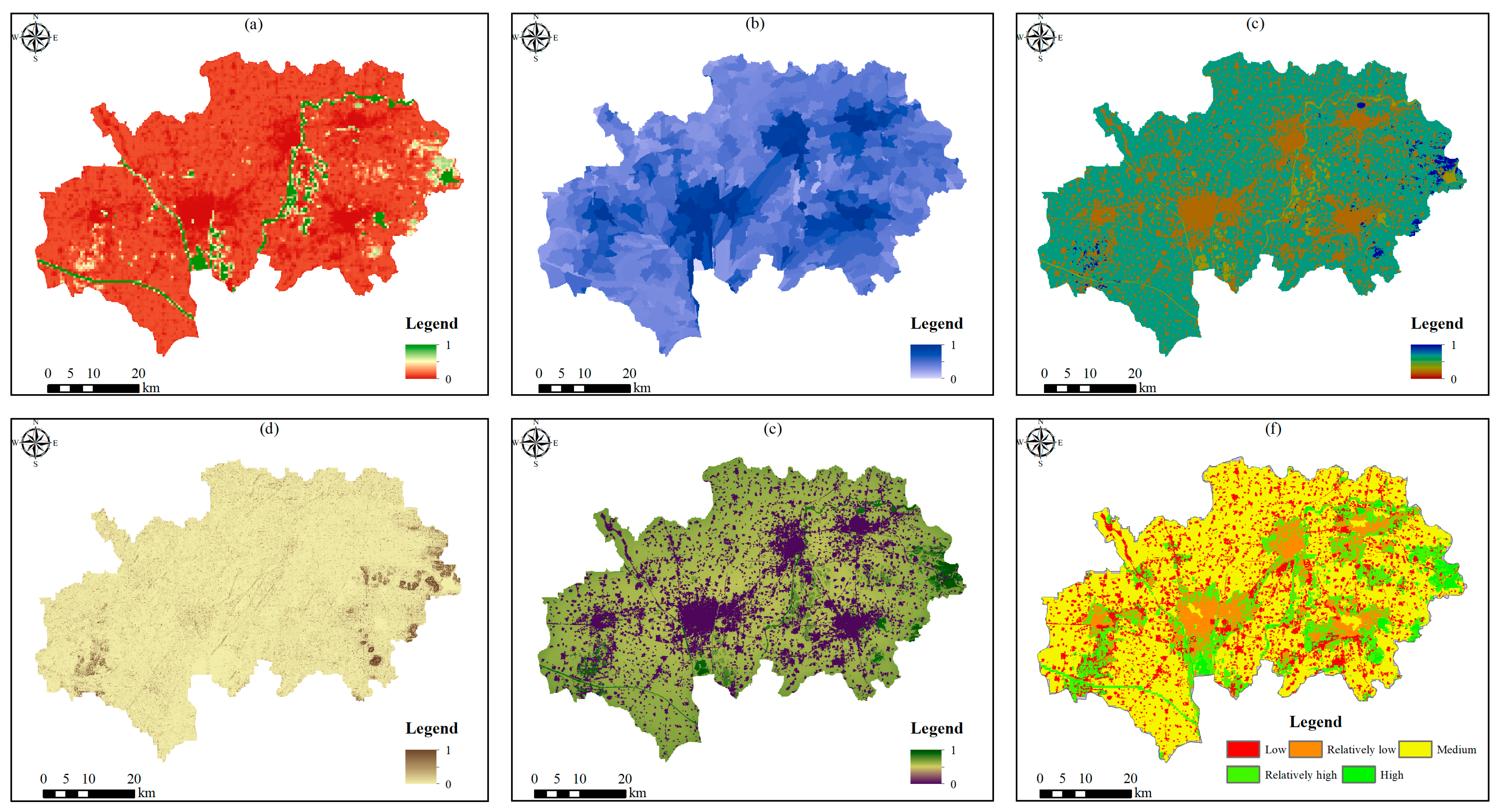
4.1.1. Ecosystem Services Importance

As shown in Figure 3a–e, the ESV and four ecosystem service functions have different spatial distribution characteristics in JPA. The high-value area of ESV is primarily distributed along the Zhuzhaoxin River, Beijing–Hangzhou Canal, Sihe River, Baima River, Taibai Lake, Nishan Reservoir, Xiwei Reservoir and other WA, Yishan National Forest Park, Qingshan, and other vegetation-rich areas. It is worth noting that the SW is also a high-value area of ESV, which is the same as in the previous research [24]. The WY of FL and GL is lower than that for other land use types because of the higher water storage capacity. The low-value area of CS is distributed in the urban area, and the high-value area is located in the FL and GL with high vegetation coverage. The overall SR capacity is relatively low, and the high-value areas are distributed in FL and GL in the southwest and east of the region, where the altitude is higher, and the slope is larger. The distribution of HQ and CS is similar, i.e., the high-quality areas are mainly distributed in FL and GL in the southwest and east. One interesting finding is that the HQ of coal mining SW is also high, as Aleš [80] pointed out that SWs are often high-quality habitats, not ecological traps.
In ArcGIS 10.8 software, the superposition results of the above five evaluations were divided into five levels via the natural breakpoint method (Figure 3f). The areas with high and relatively high importance of ecosystem services are 85.31 km2 and 507.18 km2, accounting for 2.42% and 14.41% of the total area, respectively, which are mainly distributed in rivers, reservoirs, mountains, and coal mining SWs. The area of medium importance is 2027.21 km2, accounting for 57.60% of the area, including most of the CL. In addition, the regions of relatively low and low importance possess areas of 339.30 km2 and 560.63 km2, respectively, accounting for 9.64% and 15.93% of the territory, mainly comprising CO with low vegetation coverage.

4.1.2. Ecological Source Extraction

Based on Guidos toolbox software, seven different types of landscapes were obtained (Figure 4a), of which the areas of core, bridge, edge, and islet are 430.82 km2, 5.49 km2, 109.27 km2, and 16.1 km2, accounting for 72.71%, 0.93%, 18.44%, and 2.72% of the ecological space, respectively. Among the other landscape types, the perforation area is 5.89 km2, the loop 1.73 km2, and the branch 23.19 km2. Through the analysis of the MSPA model, the top 50 with the largest areas were selected as initial ecological sources. Operating according to previous studies [29], Conefor2.6 software was used to select 2.5 km as the distance threshold for the connectivity evaluation of initial ecological sources, with a connectivity probability of 0.5, and 35 patches with dPC > 1 were selected as the final ecological sources (Figure 4b). The area of ecological sources was 227.73 km2, accounting for 6.47% of the total area of JPA, showing a pattern of “dense in the east and sparse in the west” and almost excluding CO and BL. The land use type and area of the ecological sources are shown in Table 5.

4.1.3. Ecological Resistance Surface Analysis

In terms of the method in Section 3.2, the basic resistance surface was established on the basis of land use type, elevation, and slope, and modified by the boundary of coal mines. Then, the comprehensive ecological resistance surface of JPA was obtained. The average value of the comprehensive resistance surface was 48.8 and the basic resistance surface 45.9. The basic and comprehensive ecological resistance surfaces are shown in Figure 5. The resistance distribution of the comprehensive resistance surface and the basic resistance surface is roughly similar, while the resistance value in coal mining areas is greater in the former. The high resistance values are mainly distributed in the urban areas of Qufu City, Zoucheng City, Jiaxiang County, Rencheng District, and Yanzhou District, and the principal land type is CO. The medium resistance values account for the largest range, primarily CL, seen throughout the JPA. The low resistance values are primarily found in Zhuzhaoxin River, Beijing–Hangzhou Canal, Sihe River, Nishan Reservoir, Xiwei Reservoir, Taibai Lake, and SWs, as well as FL and GL in the east and southwest. The most interesting finding is that, although coal mining has inflicted a series of problems on the environment, the ecological resistance value of the SW formed by underground mining is lower than that of surrounding areas in CMA-HGT.

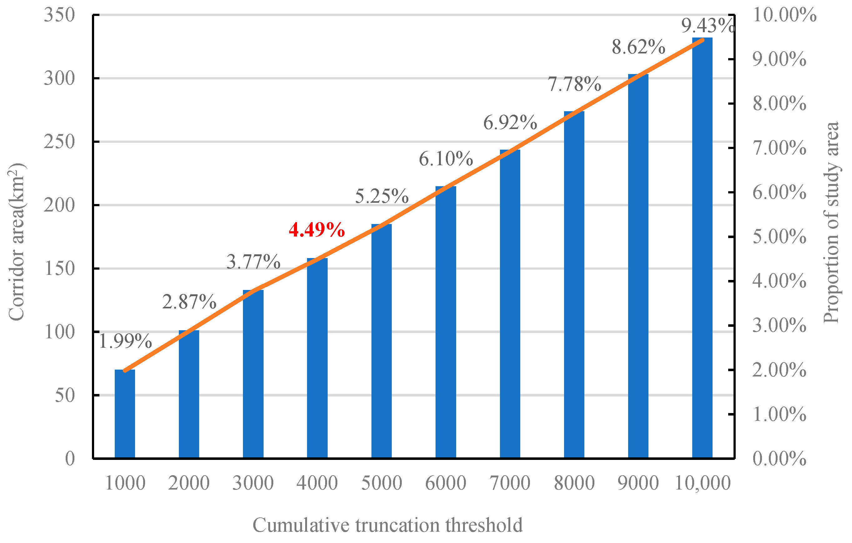
4.1.4. Ecological Corridors Identification

As shown in Figure 6a–j, the truncation threshold was increased from 1000 to 10,000, with an increment of 1000, to determine the scope of the ecological corridor. The results showed that the width of the corridor increased with the increase in the threshold, but there was no significant change in the overall spatial layout, and the area of the ecological corridor increased from 69.96 km2 to 332.05 km2 (Figure 7). Statistical comparisons of the overlapping areas of the CO and the ecological corridor (Figure 8) revealed that, in the range of 1000–10,000, the threshold of 4000 possessed the smallest growth slope, indicating that the area increased by the CO was the smallest from 3000 to 4000. Therefore, we chose 4000 as the truncation threshold with which to determine the width of the corridor.
There are 66 ecological corridors in JPA, ranging in length from 0.07 km to 31.11 km, and the total length is 377.55 km. The total area of the corridors is 158.11 km2, accounting for 4.49% of the study area. The corridors in the east are more numerous, densely distributed, and shorter; meanwhile, those in the west are sparsely distributed and distinctly linear. The ecological corridors are mainly distributed along the water system and arranged in a spider web shape in the east. Furthermore, the ecological corridors pass through the SWs in the coal mining area, which provides an important guarantee for the integrity and connectivity of ESP. As a whole, the spatial pattern of corridors is “concentrated in the east and sparse in the west” (Figure 9a).

4.1.5. Ecological Pinch Points and Barriers Identification

As a high cumulative current area, the ecological pinch point is a priority area for regional ecological protection. The current density generated by the Pinchpoint Mapper module was divided into five levels via the natural breakpoint method, and the relatively high and high-density areas were selected as ecological pinch points. See Figure 9b, 92 ecological pinch points were identified, possessing a total area of 14.96 km2 and mainly distributed in Rencheng District. A total of 41 pinch points are located on the key river corridors with an area of 6.69 km2, and the rest are distributed at the intersections of the sources and corridors.
The ecological restoration of ecological barriers, which are regarded as priority areas for ecological improvement, can significantly improve the connectivity of ecological sources. The current density generated by the Barrier Mapper module was divided into five levels by the natural breakpoint method, and the relatively high and high-density areas were selected as ecological barriers. Figure 9c shows how 80 ecological barriers were identified, with an area of 11.7 km2. The principal land use type is CO, and more than 90% of the barriers are located on ecological corridors.

4.2. EV Evaluation

The eight factors of selected natural factors and human activities were normalized, as shown in Figure 10a–h. According to the weight determined via the analytic hierarchy process, the final EV was obtained using weighted superposition with the grid calculator of ArcGIS 10.8, and the results were divided into five grades (Figure 10i). The obvious finding from the analysis is that the overall EV shows a core–periphery decreasing trend from high to low, with relatively high EV dominating and an area of 1088.35 km2, accounting for 30.92% of the total area; this is followed by areas of medium vulnerability, with a territory of 1029.01 km2 accounting for 29.24%. Both are primarily CL and coal mining areas around the urban area. In addition, the low and relatively low EV possess areas of 268.66 km2 and 592.84 km2, respectively, accounting for 7.63% and 16.84% of the study area, and they are primarily found in the eastern and western mountainous areas. The high EV areas, with an area of 540.79 km2, are mainly concentrated in the urban areas of Rencheng District, Yanzhou District, and Zoucheng City. Low vegetation coverage, high population density and GDP, and proximity to coal mines are important factors that contribute to the high EV in these areas. In particular, the high EV in the northern part of the region can be primarily explained by the dense road networks near the coal mines and away from the WA. The area of each grade is shown in Table 6.

4.3. Identification of Priority Areas for Ecological Restoration

The ecological sources located in the relatively high and high EV areas were identified as priority areas for ecological restoration, with areas of 33.16 km2 and 11.4 km2, accounting for 14.56% and 5.00% of the ecological sources, respectively, and existing mainly within the coal mine boundary and at the edge of the urban areas.
Removing ecological barriers in corridors can improve the connection quality of ecological corridors and enhance the overall ecosystem connectivity. The barriers with an area of 11.7 km2 were identified as the priority areas for ecological restoration of the corridors. On the whole, priority areas for corridor restoration are mostly located at the junctions of ecological sources and corridors.
An ecological pinch point Is a key node of high flow in the ecological process, being both irreplaceable and important in landscape connectivity [60]. The degradation or damage of pinch points will greatly weaken the connectivity of the ecological network. The ecological pinch points with relatively high and high EV were regarded as the priority areas for ecological restoration, which are mainly distributed at the boundary of coal mines, with a total area of 9.96 km2 accounting for 66.58% of the total area of ecological pinch points.
The specific locations of priority areas for ecological restoration of ecological sources, ecological corridors, and ecological pinch points are shown in Table 7 and Figure 11.

4.4. Ecological Restoration Strategies

The priority areas for ecological restoration were superimposed onto the current land use, and the restoration strategies were formulated according to the land use type and spatial distribution. The restoration of priority areas can not only improve the landscape components such as ecological sources, corridors, and nodes, but also has the potential to enhance the connection and interaction between ecosystems, form an integrated ecological function network, and achieve the goal of system restoration and comprehensive management.
(1)
The “surface”-level strategy of priority areas for ecological source restoration
As the core component involved in maintaining the stability of the ecosystem, the ecological sources should be an absolute protected area. It is necessary to protect and restore the regional ecosystem with high EV owing to its fragility and ease of degradation. According to the principle of “who damages, who reclaims” in the “Land Reclamation Regulations”, the priority areas for ecological source restoration within the boundary of coal mines should be protected and repaired by mining enterprises. In the process of mining, the negative impact on the ecological environment should be minimized. The “Green Mine Construction Specification for Coal Industry” issued in 2018 can play a guiding and restraining role. To address the ground subsidence caused by coal mining, land reclamation can be carried out by means of land leveling, filling, deep digging, and shallow filling, while the permanent water accumulation area deeper than 3 m can be repaired as SW [20]. It is particularly important that, if the priority area for ecological source restoration coincides with the predicted mining subsidence area, in order to ensure that the ecological source is not damaged it is necessary to implement concurrent mining and reclamation [81]. The treatment of the priority area for ecological source restoration outside the boundary of coal mines should improve the quality of CL, strengthen the protection of FL, improve the hydrological conditions of WA and SWs, and prevent pollution.
(2)
The “line”-level strategy of priority areas for ecological corridor restoration
Different restoration measures were proposed according to the types of ecological barriers. Most of the barriers are CO and CL, accounting for 42.90% and 39.74% of the total area of barriers, respectively. Given that in 2016, the Ministry of Natural Resources decided to reduce the CL index for coal mining subsidence in Jining by 114 km2, implementing the Grain for Green project can be considered for low-quality CL. If the CO area is large and seriously damaged, especially in the overlapping area with the predicted coal mining subsidence, buildings can be demolished and converted into other types of landscape features. When comprehensively considering important factors such as the local economy, the buildings cannot be converted into other landscape types, which can be altered by reserving animal migration channels around the CO. Some of the ecological barriers are FL, WA, and SW. These have low resistance values but high resistance values, which is mainly because they are close to coal mining areas. The restoration of both vegetation and the mine’s ecological environment must be taken into account in the corresponding ecological restoration.
(3)
The “point”-level strategy of priority areas for ecological pinch point restoration
In the restoration of the ecological pinch points located along rivers and in wetlands, river buffer zones should be built, suitable tree species should be planted along the river shoreline, pollutant emissions during mining and planting should be strictly controlled, the restoration and management of water bodies should be strengthened, and the management system should be perfected to improve water quality. For the ecological pinch points dominated by CL and FL, FL cultivation and the reversion of farmland to forest and grass should be carried out to minimize disturbance from human activities. In the restoration of the ecological pinch points located in the traffic network, the green belt on both sides of the road should be widened, and warning signs should be erected to reduce the speed of vehicles and weaken the influence of noise, dust, and exhaust gas on the habitat. If the pinch points are located in CO, relevant improvement facilities should be established where conditions permit, such as special channels, overpasses, or tunnels for wildlife migration.

5. Discussion

5.1. Ecological Impact of Coal Mining in CMA-HGT

The impact of coal mining on the environment is very complex in CMA-HGT [81,82]. On the one hand, the economic development brought by mining has accelerated the process of urbanization, and underground mining has seriously disturbed the surface, resulting in large-scale land subsidence and farmland degradation [7,19,83]. In particular, from 2003 to 2012, China’s coal industry experienced a “golden” decade, which led to the rapid expansion of CO and land subsidence in the study area, both of which exert pressure on regional ecological security. On the other hand, the exploitation of underground coal has created new wetlands in CMA-HGT [84]. In the absence of long-term disturbance and restoration, the post-mining landscape in many areas has formed a new core area with high ecological value, providing habitat for many species and even endangered species [85,86], and becoming an important composition of ecological sources. In the study area, biological species, such as Aythya baeri (one of the world’s critically endangered species) and reed parrotbill (world endangered species), were discovered settling in coal mining SWs. In addition, according to a survey conducted in 2020, there are 6 species from 4 families of amphibians, 7 species from 5 families of reptiles, and 24 species from 11 families of fish in Taiping National Wetland Park with predecessors in coal mining SWs in the study area, and the number of plants has grown from less than 200 to 400, while the number of bird species has increased from 75 to 167, including 13 rare bird species under national second-level protection and 7 endangered bird species. SWs possess strong development potential in future ecological restoration [21].

5.2. Advantages of Research Methods

Ecological restoration priority areas can highlight the focus of ecological protection and restoration and provide an important scientific basis for the establishment and improvement of ecological protection and restoration policies. The identification of key areas for ecological restoration based on ecological processes and landscape patterns according to the ESP [60], although considering the overall protection and system restoration, is limited by the resistance surface and cannot fully consider the impact of factors such as human activities on the ecological environment. Meanwhile, ESP cannot determine the restoration order of key ecological restoration areas, i.e., the priority areas of ecological restoration, in order to maximize restoration funds. However, EV can be achieved by constructing a multi-angle evaluation system, comprehensively analyzing the changes in the ecological environment caused by the combined effects of natural and human factors. Therefore, the key areas with high EV can be identified as priority areas for ecological restoration, which can make up for the lack of funds. Hence, it is possible to see that ESP and EV complement each other perfectly. In view of this, this paper combined ESP with EV to identify the ecologically vulnerable areas in the key areas of ecological restoration and use them as priority areas to guide the corresponding ecological restoration projects under limited funds.

5.3. Limitations and Directions for Future Research

First of all, the data used in this study are from 2021. In fact, however, the regional ecosystem changes as time progresses, and coal mines evolve faster in the process of mining and reclamation. Therefore, in future studies, long-term time series data and the prediction of land subsidence and land use types should be given sufficient consideration. Secondly, when establishing the EV, only the negative impacts of human activities on the ecosystem were considered, and the positive impacts such as environmental protection investment were ignored, which needs to be further improved in subsequent studies. Finally, some ecological restoration strategies were put forward in this paper, but the specific restoration measures, such as the optimization scale of the patch area, the establishment standard of the ecological channel, and so on, may incur errors with the actual landscape pattern, resulting in uncertainty in the actual restoration operation. It is necessary to conduct further research in combination with practice in the future.

6. Conclusions

The identification of ecological restoration priority areas can maximize the ecological restoration benefits of limited funds in areas that require large-scale ecological restoration. We proposed a method combining ESP with EV to identify priority areas for ecological restoration, which can make up for the lack of consideration of the order of restoration in the existing ecological restoration research. This method can locate the areas that need priority restoration in order to carry out land space planning and implement ecological restoration measures. JPA, a typical coal mining area with a high groundwater table, was chosen as the study area, and the findings will provide a scientific reference for the identification and restoration of priority areas for ecological restoration in CMA-HGT, such as the Huainan coal mining area and Huaibei coal mining area in Anhui Province, the Peibei coal mining area and Jiawang coal mining area in Jiangsu Province, etc.
In this paper, the priority areas for ecological restoration in JPA were identified based on ESP and EV, and the results showed that: (1) In JPA, there were 35 ecological sources with an area of 227.73 km2 and 66 ecological corridors with a total area of 158.11 km2 and a total length of 377.55 km. There were 92 ecological pinch points, and 80 ecological barriers were found. (2) The overall EV showed a core–periphery decreasing trend from high to low, and medium and relatively high EV together accounted for 60.16% of the total area. The role of coal mines and transportation networks in enhancing vulnerability cannot be ignored. (3) The priority areas for ecological restoration of ecological sources, ecological corridors, and ecological pinch points were 44.56 km2, 11.7 km2, and 9.96 km2, respectively. Combined with the spatial distribution and typical problems of each ecological restoration priority area, ecological restoration strategies of “surface line point” were proposed.
Undoubtedly, this study has deepened the understanding of the relationship between ESP and EV. In addition to exploration, this paper provides a new perspective for the formulation and implementation of regional ecological restoration planning. The most important is that the identification of ecological restoration priority areas based on ESP and EV provides a reliable method and a valuable direction for the investment of ecological restoration funds.

Author Contributions

Conceptualization, Y.H. and L.D.; methodology, L.D.; software, L.D. and S.Z.; validation, L.D., Y.H. and K.Q.; formal analysis, S.Z.; investigation, L.D. and K.Q.; resources, L.D.; writing—original draft preparation, L.D., Y.H. and S.Z.; writing—review and editing, Y.H.; supervision, Y.H.; project administration, S.Z.; funding acquisition, S.Z. All authors have read and agreed to the published version of the manuscript.

Funding

This research was funded by the National Key Research and Development Plan (Grant no. 2017YFC1503103).

Institutional Review Board Statement

Not applicable.

Informed Consent Statement

Informed consent was obtained from all subjects involved in the study.

Data Availability Statement

The data presented in this study are available on request from the corresponding author. The data are not publicly available due to privacy.

Conflicts of Interest

The authors declare no conflicts of interest.

References

  1. Rong, H.; Cheng, T. Research and Control of Underground Pressure Law of Coal Mining Face in Soft Rock Strata Based on Neural Network under the Background of Wireless Network Communication. Mob. Inf. Syst. 2021, 2021, 6560713. [Google Scholar] [CrossRef]
  2. He, G.; Yu, B.; Li, S.; Zhu, Y. Comprehensive evaluation of ecological security in mining area based on PSR-ANP-GRAY. Environ. Technol. 2018, 39, 3013–3019. [Google Scholar] [CrossRef]
  3. Li, S.; Zhao, Y.; Xiao, W.; Yue, W.; Wu, T. Optimizing ecological security pattern in the coal resource-based city: A case study in Shuozhou City, China. Ecol. Indic. 2021, 130, 108026. [Google Scholar] [CrossRef]
  4. Fan, F.; Wen, X.; Feng, Z.; Gao, Y.; Li, W. Optimizing urban ecological space based on the scenario of ecological security patterns: The case of central Wuhan, China. Appl. Geogr. 2022, 138, 102619. [Google Scholar] [CrossRef]
  5. Farrington, J.D. The Impact of Mining Activities on Mongolia’s Protected Areas: A Status Report with Policy Recommendations. Integr. Environ. Assess. Manag. 2005, 1, 283–289. [Google Scholar] [CrossRef]
  6. Li, S.; Xiao, W.; Zhao, Y.; Lv, X. Incorporating ecological risk index in the multi-process MCRE model to optimize the ecological security pattern in a semi-arid area with intensive coal mining: A case study in northern China. J. Clean. Prod. 2020, 247, 119143. [Google Scholar] [CrossRef]
  7. Xiao, W.; Hu, Z.; Chugh, Y.P.; Zhao, Y. Dynamic subsidence simulation and topsoil removal strategy in high groundwater table and underground coal mining area: A case study in Shandong Province. Int. J. Min. Reclam. Environ. 2014, 28, 250–263. [Google Scholar] [CrossRef]
  8. Gueguen, Y.; Deffontaines, B.; Fruneau, B.; Al Heib, M.; de Michele, M.; Raucoules, D.; Guise, Y.; Planchenault, J. Monitoring residual mining subsidence of Nord/Pas-de-Calais coal basin from differential and Persistent Scatterer Interferometry (Northern France). J. Appl. Geophys. 2009, 69, 24–34. [Google Scholar] [CrossRef]
  9. He, L.; Wang, X.; Liu, C.; Tang, Y.; Zhang, X.; Kang, J.; Guo, C.; Hea, R. Time series interferometric synthetic aperture radar-based modeling and analysis of complex land subsidence caused by multi-seam coal mining on the Liaohe Plain, China. J. Appl. Remote Sens. 2022, 16, 024512. [Google Scholar] [CrossRef]
  10. Zhao, Y.; Zheng, W.; Xiao, W.; Zhang, S.; Lv, X.; Zhang, J. Rapid monitoring of reclaimed farmland effects in coal mining subsidence area using a multi-spectral UAV platform. Environ. Monit. Assess. 2020, 192, 474. [Google Scholar] [CrossRef]
  11. Grzovic, M.; Ghulam, A.J.N.H. Evaluation of land subsidence from underground coal mining using TimeSAR (SBAS and PSI) in Springfield, Illinois, USA. Nat. Hazards 2015, 79, 1739–1751. [Google Scholar] [CrossRef]
  12. Bruecker, C.; Preusse, A. The future of underground spatial planning and the resulting potential risks from the point of view of mining subsidence engineering. Int. J. Min. Sci. Technol. 2020, 30, 93–98. [Google Scholar] [CrossRef]
  13. Morrison, K.; Reynolds, J.; Wright, I.A. Underground coal mining and subsidence, channel fracturing and water pollution: A five-year investigation. In Proceedings of the 9th Australian Stream Managemet Conference, Hobart, Australia, 16 August 2018; pp. 673–680. [Google Scholar]
  14. Monika; Govil, H.; Guha, S. Underground mine deformation monitoring using Synthetic Aperture Radar technique: A case study of Rajgamar coal mine of Korba Chhattisgarh, India. J. Appl. Geophys. 2023, 209, 104899. [Google Scholar] [CrossRef]
  15. Chugh, Y.P. Concurrent mining and reclamation for underground coal mining subsidence impacts in China. In Proceedings of the 2nd International Symposium on Land Reclamation and Ecological Restoration (LRER), China Coal Soc, Xi’an, China, 20–23 October 2017; pp. 315–332. [Google Scholar]
  16. Larondelle, N.; Haase, D. Valuing post-mining landscapes using an ecosystem services approach-An example from Germany. Ecol. Indic. 2012, 18, 567–574. [Google Scholar] [CrossRef]
  17. He, T.; Xiao, W.; Zhao, Y.; Chen, W.; Deng, X.; Zhang, J. Continues monitoring of subsidence water in mining area from the eastern plain in China from 1986 to 2018 using Landsat imagery and Google Earth Engine. J. Clean. Prod. 2021, 279, 123610. [Google Scholar] [CrossRef]
  18. Li, S.; Zhao, Y.; Xiao, W.; Yellishetty, M.; Yang, D. Identifying ecosystem service bundles and the spatiotemporal characteristics of trade-offs and synergies in coal mining areas with a high groundwater table. Sci. Total Environ. 2022, 807, 151036. [Google Scholar] [CrossRef]
  19. Hu, Z.; Yang, G.; Xiao, W.; Li, J.; Yang, Y.; Yu, Y. Farmland damage and its impact on the overlapped areas of cropland and coal resources in the eastern plains of China. Resour. Conserv. Recycl. 2014, 86, 1–8. [Google Scholar] [CrossRef]
  20. Li, G.; Hu, Z.; Li, P.; Yuan, D.; Wang, W.; Han, J.; Yang, K. Optimal layout of underground coal mining with ground development or protection: A case study of Jining, China. Resour. Policy 2022, 76, 102639. [Google Scholar] [CrossRef]
  21. Yang, Y.; Zhang, Y.; Su, X.; Hou, H.; Zhang, S. The spatial distribution and expansion of subsided wetlands induced by underground coal mining in eastern China. Environ. Earth Sci. 2021, 80, 112. [Google Scholar] [CrossRef]
  22. Chen, F.; Zhu, Y.; Ma, J.; Yang, Y.; You, Y.; Wang, L. Cooperative remediation mechanism and key technologies for pollution reduction and carbon sequestration in coal mining subsidence areas of the eastern plain. J. China Coal Soc. 2023, 48, 2836–2849. [Google Scholar] [CrossRef]
  23. Arturo Aguirre-Salado, C.; Miranda-Aragon, L.; Pompa-Garcia, M.; Reyes-Hernandez, H.; Soubervielle-Montalvo, C.; Alberto Flores-Cano, J.; Mendez-Cortes, H. Improving Identification of Areas for Ecological Restoration for Conservation by Integrating USLE and MCDA in a GIS-Environment: A Pilot Study in a Priority Region Northern Mexico. Isprs Int. J. Geo-Inf. 2017, 6, 262. [Google Scholar] [CrossRef]
  24. Hu, T.; Chang, J.; Liu, X.; Feng, S. Integrated methods for determining restoration priorities of coal mining subsidence areas based on green infrastructure: -A case study in the Xuzhou urban area, of China. Ecol. Indic. 2018, 94, 164–174. [Google Scholar] [CrossRef]
  25. Menz, M.H.M.; Dixon, K.W.; Hobbs, R.J. Hurdles and Opportunities for Landscape-Scale Restoration. Science 2013, 339, 526–527. [Google Scholar] [CrossRef] [PubMed]
  26. Holl, K.D.; Crone, E.E.; Schultz, C.B. Landscape restoration: Moving from generalities to methodologies. Bioscience 2003, 53, 491–502. [Google Scholar] [CrossRef]
  27. Gama, V.F.; Martensen, A.C.; Ponzoni, F.J.; Hirota, M.M.; Ribeiro, M.C. Site Selection for Restoration Planning: A Protocol with Landscape and Legislation Based Alternatives. Nat. Conserv. 2013, 11, 158–169. [Google Scholar] [CrossRef]
  28. Xiao, W.; Fu, Y.; Wang, T.; Lv, X. Effects of land use transitions due to underground coal mining on ecosystem services in high groundwater table areas: A case study in the Yanzhou coalfield. Land Use Policy 2018, 71, 213–221. [Google Scholar] [CrossRef]
  29. Li, Z.; Chang, J.; Li, C.; Gu, S. Ecological Restoration and Protection of National Land Space in Coal Resource-Based Cities from the Perspective of Ecological Security Pattern: A Case Study in Huaibei City, China. Land 2023, 12, 442. [Google Scholar] [CrossRef]
  30. Yang, K.; Wang, S.; Cao, Y.; Li, S.; Zhou, W.; Liu, S.; Bai, Z. Ecological Restoration of a Loess Open-Cast Mining Area in China: Perspective from an Ecological Security Pattern. Forests 2022, 13, 269. [Google Scholar] [CrossRef]
  31. Zhai, T.; Huang, L. Linking MSPA and Circuit Theory to Identify the Spatial Range of Ecological Networks and Its Priority Areas for Conservation and Restoration in Urban Agglomeration. Front. Ecol. Evol. 2022, 10, 828979. [Google Scholar] [CrossRef]
  32. Zhang, J.; Chen, H.; Ma, Y.; Liu, D.; Liang, X.; Chen, W. Identification of priority areas for ecological restoration based on ecological security and landscape elements. Environ. Sci. Pollut. Res. 2023, 30, 35307–35325. [Google Scholar] [CrossRef]
  33. Liu, J.; Yang, S.; Lü, Y. Identification and diagnosis of critical areas for ecological rehabilitation based on eco-security patterns and ecological vulnerability assessment—A case study over Wenshang County. China Environ. Sci. 2022, 42, 3343–3352. [Google Scholar] [CrossRef]
  34. Ke, S.; Pan, H.; Jin, B. Identification of Priority Areas for Ecological Restoration Based on Human Disturbance and Ecological Security Patterns: A Case Study of Fuzhou City, China. Sustainability 2023, 15, 2842. [Google Scholar] [CrossRef]
  35. Wang, D.; Chen, J.; Zhang, L.; Sun, Z.; Wang, X.; Zhang, X.; Zhang, W. Establishing an ecological security pattern for urban agglomeration, taking ecosystem services and human interference factors into consideration. PeerJ 2019, 7, e7306. [Google Scholar] [CrossRef]
  36. Wen, J.; Hou, K. Research on the progress of regional ecological security evaluation and optimization of its common limitations. Ecol. Indic. 2021, 127, 107797. [Google Scholar] [CrossRef]
  37. Kattel, G.R.; Elkadi, H.; Meikle, H. Developing a complementary framework for urban ecology. Urban For. Urban Green. 2013, 12, 498–508. [Google Scholar] [CrossRef]
  38. Ma, R.; Zhou, W.; Ren, J.; Huang, Y.; Wang, H. Multi-scenario simulation and optimization control of ecological security based on GeoSOS-FLUS model in ecological fragile area in northeast Qinghai-Tibet Plateau, China. Ecol. Indic. 2023, 151, 110324. [Google Scholar] [CrossRef]
  39. Peng, J.; Guo, X.; Hu, Y.; Liu, Y. Constructing ecological security patterns in mountain areas based on geological disaster sensitivity: A case study in Yuxi City, Yunnan Province, China. Chin. J. Appl. Ecol. 2017, 28, 627–635. [Google Scholar] [CrossRef]
  40. Jia, Q.; Jiao, L.; Lian, X.; Wang, W. Linking supply-demand balance of ecosystem services to identify ecological security patterns in urban agglomerations. Sustain. Cities Soc. 2023, 92, 104497. [Google Scholar] [CrossRef]
  41. Chen, X.; Zhou, C. Review of the studies on ecological security. Prog. Geogr. 2005, 24, 8–20. [Google Scholar]
  42. Wang, T.; Li, H.; Huang, Y. The complex ecological network’s resilience of the Wuhan metropolitan area. Ecol. Indic. 2021, 130, 108101. [Google Scholar] [CrossRef]
  43. Yu, K. Security patterns and surface model in landscape ecological planning. Landsc. Urban Plan. 1996, 36, 1–17. [Google Scholar] [CrossRef]
  44. Wei, Q.; Halike, A.; Yao, K.; Chen, L.; Balati, M. Construction and optimization of ecological security pattern in Ebinur Lake Basin based on MSPA-MCR models. Ecol. Indic. 2022, 138, 1–13. [Google Scholar] [CrossRef]
  45. Yang, R.; Bai, Z.; Shi, Z. Linking Morphological Spatial Pattern Analysis and Circuit Theory to Identify Ecological Security Pattern in the Loess Plateau: Taking Shuozhou City as an Example. Land 2021, 10, 907. [Google Scholar] [CrossRef]
  46. Wang, Z.; Shi, P.; Zhang, X.; Tong, H.; Zhang, W.; Liu, Y. Research on Landscape Pattern Construction and Ecological Restoration of Jiuquan City Based on Ecological Security Evaluation. Sustainability 2021, 13, 5732. [Google Scholar] [CrossRef]
  47. Wang, Y.; Li, J.; Gu, K.; Lu, L. Optimization of urban green infrastructure network layout based on MSPA-CIRCUIT: Case of Hefei. Acta Ecol. Sin. 2022, 42, 2022–2032. [Google Scholar] [CrossRef]
  48. Wu, C.; Zhou, Z.; Wang, P.; Xiao, W.; Teng, M. The concept and measurement of landscape connectivity and its application. Acta Ecol. Sin. 2010, 30, 1903–1910. [Google Scholar]
  49. Wang, Y. The connectivity evaluation of Shanghai urban landscape eco-network. Geogr. Res. 2009, 28, 284–292. [Google Scholar]
  50. Xu, X.; Peng, Y. Ecological Compensation in Zhijiang City Based on Ecosystem Service Value and Ecological Risk. Sustainability 2023, 15, 4783. [Google Scholar] [CrossRef]
  51. Su, Y.; Ma, X.; Feng, Q.; Liu, W.; Zhu, M.; Niu, J.; Liu, G.; Shi, L. Patterns and controls of ecosystem service values under different land-use change scenarios in a mining-dominated basin of northern China. Ecol. Indic. 2023, 151, 110321. [Google Scholar] [CrossRef]
  52. Xiang, H.; Zhang, J.; Mao, D.; Wang, M.; Yu, F.; Wang, Z.; Li, H. Optimizing ecological security patterns considering zonal vegetation distribution for regional sustainability. Ecol. Eng. 2023, 194, 107055. [Google Scholar] [CrossRef]
  53. Zhao, Y.; Ning, B.; Wang, R. Research on ecological network problem identification of Shenmu based on InVEST and MCR model. Territ. Nat. Resour. Study 2023, 55–60. [Google Scholar] [CrossRef]
  54. Keeley, A.T.H.; Beier, P.; Gagnon, J.W. Estimating landscape resistance from habitat suitability: Effects of data source and nonlinearities. Landsc. Ecol. 2016, 31, 2151–2162. [Google Scholar] [CrossRef]
  55. Gou, M.; Li, L.; Ouyang, S.; Shu, C.; Xiao, W.; Wang, N.; Hu, J.; Liu, C. Integrating ecosystem service trade-offs and rocky desertification into ecological security pattern construction in the Daning river basin of southwest China. Ecol. Indic. 2022, 138, 108845. [Google Scholar] [CrossRef]
  56. Dai, L.; Liu, Y.; Luo, X. Integrating the MCR and DOI models to construct an ecological security network for the urban agglomeration around Poyang Lake, China. Sci. Total Environ. 2021, 754, 141868. [Google Scholar] [CrossRef]
  57. Gao, J.; Du, F.; Zuo, L.; Jiang, Y. Integrating ecosystem services and rocky desertification into identification of karst ecological security pattern. Landsc. Ecol. 2021, 36, 2113–2133. [Google Scholar] [CrossRef]
  58. Peng, J.; Pan, Y.; Liu, Y.; Zhao, H.; Wang, Y. Linking ecological degradation risk to identify ecological security patterns in a rapidly urbanizing landscape. Habitat Int. 2018, 71, 110–124. [Google Scholar] [CrossRef]
  59. An, Y.; Liu, S.; Sun, Y.; Shi, F.; Beazley, R. Construction and optimization of an ecological network based on morphological spatial pattern analysis and circuit theory. Landsc. Ecol. 2021, 36, 2059–2076. [Google Scholar] [CrossRef]
  60. Peng, J.; Yang, Y.; Liu, Y.; Hu, Y.n.; Du, Y.; Meersmans, J.; Qiu, S. Linking ecosystem services and circuit theory to identify ecological security patterns. Sci. Total Environ. 2018, 644, 781–790. [Google Scholar] [CrossRef]
  61. Huang, J.; Hu, Y.; Zheng, F. Research on recognition and protection of ecological security patterns based on circuit theory: A case study of Jinan City. Environ. Sci. Pollut. Res. 2020, 27, 12414–12427. [Google Scholar] [CrossRef]
  62. Wei, B.; Su, J.; Hu, X.; Xu, K.; Zhu, M.; Liu, L. Comprehensive identification of eco-corridors and eco-nodes based on principle of hydrological analysis and linkage mapper. Acta Ecol. Sin. 2022, 42, 2995–3009. [Google Scholar] [CrossRef]
  63. Beroya-Eitner, M.A. Ecological vulnerability indicators. Ecol. Indic. 2016, 60, 329–334. [Google Scholar] [CrossRef]
  64. Pan, Z.; Gao, G.; Fu, B. Spatiotemporal changes and driving forces of ecosystem vulnerability in the Yangtze River Basin, China: Quantification using habitat-structure-function framework. Sci. Total Environ. 2022, 835, 155494. [Google Scholar] [CrossRef] [PubMed]
  65. Turner, B.L.; Kasperson, R.E.; Matson, P.A.; McCarthy, J.J.; Corell, R.W.; Christensen, L.; Eckley, N.; Kasperson, J.X.; Luers, A.; Martello, M.L.; et al. A framework for vulnerability analysis in sustainability science. Proc. Natl. Acad. Sci. USA 2003, 100, 8074–8079. [Google Scholar] [CrossRef] [PubMed]
  66. Wu, X.; Tang, S. Comprehensive evaluation of ecological vulnerability based on the AHP-CV method and SOM model: A case study of Badong County, China. Ecol. Indic. 2022, 137, 108758. [Google Scholar] [CrossRef]
  67. Xu, D.; Guo, X.; Watanabe, T.; Liang, K.; Kou, J.; Jiang, X. Ecological Security Pattern Construction in Rural Settlements Based on Importance and Vulnerability of Ecosystem Services: A Case Study of the Southeast Region of Chongqing, China. Sustainability 2023, 15, 7477. [Google Scholar] [CrossRef]
  68. Ferreira, A.; Pereira, A.; Rodrigues, N.; Barbosa, J.; Leitao, P.; IEEE. Integration of an Agent-based Strategic Planner in an Enterprise Service Bus Ecosystem. In Proceedings of the 13th IEEE International Conference on Industrial Informatics (INDIN), Cambridge, UK, 22–24 July 2015; pp. 1336–1341. [Google Scholar]
  69. Costanza, R.; Arge; Groot, R.D.; Farberk, S.; Belt, M.V.D.J.N. The value of the world’s ecosystem services and natural capital. Nature 1997, 387, 253–260. [Google Scholar] [CrossRef]
  70. Xie, G.; Zhang, C.; Zhang, C.; Xiao, Y.; Lu, C. The value of ecosystem services in China. Resour. Sci. 2015, 37, 1740–1746. [Google Scholar]
  71. Zhang, L.; Dawes, W.R.; Walker, G.R. Response of mean annual evapotranspiration to vegetation changes at catchment scale. Water Resour. Res. 2001, 37, 701–708. [Google Scholar] [CrossRef]
  72. Qin, H. Land Use Scenario Simulation and Ecosystem Service Prediction in Shandong Province. Master’s Thesis, Shandong University, Jinan, China, 2022. [Google Scholar]
  73. Jordaan, A.; Bahta, Y.T.; Phatudi-Mphahlele, B. Ecological vulnerability indicators to drought: Case of communal farmers in Eastern Cape, South Africa. Jamba J. Disaster Risk Stud. 2019, 11, 591. [Google Scholar] [CrossRef]
  74. Soille, P.; Vogt, P. Morphological segmentation of binary patterns. Pattern Recognit. Lett. 2009, 30, 456–459. [Google Scholar] [CrossRef]
  75. Lin, J.; Huang, C.; Wen, Y.; Liu, X. An assessment framework for improving protected areas based on morphological spatial pattern analysis and graph-based indicators. Ecol. Indic. 2021, 130, 108138. [Google Scholar] [CrossRef]
  76. Hu, X.; Jia, T. Construction and optimization of ecological security pattern in Three-River-Source National Park based on ecological sensitivity and landscape connectivity. Resour. Environ. Yangtze Basin 2023, 32, 1724–1735. [Google Scholar]
  77. Liao, C.; Liu, X. Identifying the mining impact range on the vegetation of Yangquan coal mining region by using 3S technology. J. Nat. Resour. 2010, 25, 185–191. [Google Scholar]
  78. Dong, J.; Peng, J.; Xu, Z.; Liu, Y.; Wang, X.; Li, B. Integrating regional and interregional approaches to identify ecological security patterns. Landsc. Ecol. 2021, 36, 2151–2164. [Google Scholar] [CrossRef]
  79. Li, Y.; Liu, W.; Feng, Q.; Zhu, M.; Yang, L.; Zhang, J.; Yin, X. The role of land use change in affecting ecosystem services and the ecological security pattern of the Hexi Regions, Northwest China. Sci. Total Environ. 2023, 855, 158940. [Google Scholar] [CrossRef] [PubMed]
  80. Dolny, A.; Harabis, F. Underground mining can contribute to freshwater biodiversity conservation: Allogenic succession forms suitable habitats for dragonflies. Biol. Conserv. 2012, 145, 109–117. [Google Scholar] [CrossRef]
  81. Hu, Z.; Xiao, W. New idea and new technology of mine land reclamation: Concurrent mining and reclamation. Coal Sci. Technol. 2013, 41, 178–181. [Google Scholar] [CrossRef]
  82. Wang, Z.; Luo, K.; Zhao, Y.; Lechner, A.M.; Wu, J.; Zhu, Q.; Sha, W.; Wang, Y. Modelling regional ecological security pattern and restoration priorities after long-term intensive open-pit coal mining. Sci. Total Environ. 2022, 835, 155491. [Google Scholar] [CrossRef]
  83. Xiao, W.; Wang, Z.; Zhang, R. The ‘golden ten years’: Underground coal mining and its impacts on land use and subsequent social problems: A case study on the Jining city region, China. Int. J. Min. Miner. Eng. 2017, 8, 19–34. [Google Scholar] [CrossRef]
  84. Zhang, M.; Yuan, X.; Guan, D.; Liu, H.; Zhang, G.; Wang, K.; Zhou, L.; Wu, S.; Sun, K. Eco-exergy Evaluation of New Wetlands in the Yanzhou Coalfield Subsidence Areas Using Structural-Dynamic Modelling. Mine Water Environ. 2019, 38, 746–756. [Google Scholar] [CrossRef]
  85. Chang, J. From Post-Mining Landscape to Urban Space. Flächenmanag. Bodenordn. 2013, 34, 73–78. [Google Scholar]
  86. Chang, J.T.K. From abandoned mine land to landscape park. J. China Coal Soc. 2005, 30, 399–402. [Google Scholar]
Figure 1. Location of study area (The red star denotes Beijing, the capital of China).
Sustainability 16 00159 g001
Figure 2. Framework for identifying priority areas for ecological restoration.
Sustainability 16 00159 g002
Figure 3. Spatial distributions of ecosystem services. (a) Importance of ecosystem service value; (b) importance of water yield; (c) importance of carbon storage; (d) importance of soil retention; (e) importance of habitat quality; (f) importance of ecosystem services.
Sustainability 16 00159 g003
Figure 4. (a) Results of MSPA; (b) ecological sources.
Sustainability 16 00159 g004
Figure 5. Spatial distributions of the resistance surface. (a) Resistance of different land use types; (b) resistance of different DEM; (c) resistance of different slopes; (d) coefficient of boundary of coal mines; (e) basic resistance surface; (f) comprehensive resistance surface.
Sustainability 16 00159 g005
Figure 6. Width of ecological corridors and cumulative current values.
Sustainability 16 00159 g006
Figure 7. Corridor area under different thresholds (The red “4.49%” denotes that the corridor area accounts for 4.49% of the study area when the cumulative truncation threshold is 4000).
Sustainability 16 00159 g007
Figure 8. Overlapping area between different corridor ranges and construction land (The red “k = 0.0014” denotes that the growth slope k is 0.0014 from 3000 to 4000 of the cumulative truncation threshold).
Sustainability 16 00159 g008
Figure 9. Spatial distribution of ecological (a) corridors; (b) pinch points; and (c) barriers.
Sustainability 16 00159 g009
Figure 10. Spatial distribution of ecological vulnerability. (a) DEM; (b) NDVI; (c) degree of soil erosion; (d) distance from water; (e) population density; (f) GDP; (g) distance from coal mines; (h) distance from roads; and (i) ecological vulnerability.
Sustainability 16 00159 g010
Figure 11. Priority areas of ecological restoration in study area.
Sustainability 16 00159 g011
Table 1. The evaluation methods of ecosystem services.
Ecosystem ServicesEvaluation MethodBasic Principle
Ecosystem service valueEcosystem service value
equivalent factor method
M = 1 7 × P × Q , where M denotes the economic value of unit equivalent factor (CNY/km2), P denotes the average grain price (the study area, CNY/kg), and Q denotes the average annual grain yield (the study area, kg/km2) [70].
Water yieldInVEST model
Water Yield module
Y xj = ( 1 AET xj P x ) · P x , where Yxj is the water yield (mm) of the grid x of the jth land use type, AETxj is the actual evapotranspiration (mm) of the grid x, and Px is the precipitation of the grid x (mm) [67,71].
Carbon storageInVEST model
Carbon Storage and Sequestration module
C = i = 0 n A i × C above + C below + C soil + C dead , where C is carbon storage (t), and Ai is the area of each land use type (km2); four carbon pools refer to the carbon density of different parts of each land use type, which are aboveground biomass (Cabove, t/km2), belowground biomass (Cbelow, t/km2), soil carbon density (Csoil, t/km2), and dead organic carbon density (Cdead, t/km2) [67]. The carbon density of the study area refers to the research results of adjacent areas with similar conditions [72].
Soil retentionInVEST model
Sediment Delivery Ratio module
A = R × K × LS × (1 − CP), where A is annual average soil erosion, R is rainfall erosion coefficient, K is soil erodibility coefficient, LS is topographic factor, C is vegetation cover and management factor, and P is soil and water conservation measure factor [35].
Habitat qualityInVEST model
Habitat Quality module
Q xj =   H j ( 1 D xj 2 D xj 2 + k 2 ) , where Qxj is the habitat quality of land use type j in grid x, Hj is the habitat suitability of land use type j, Dxj is the habitat threat level of land use type j in grid x, and k is the semi-saturation constant [57].
Table 2. The weight and value of resistance factors.
FactorWeightResistance Value
15105075100
Land use type0.7WatersSubsidence wetlandForest landCultivated land, grasslandBare landConstruction land
DEM (m)0.1[0, 25)-[25, 50)[50, 100)[100, 200)[200, 568)
Slope (°)0.2[0, 8)-[8, 15)[15, 25)[25, 35)[35, 59)
Table 3. Ecological vulnerability evaluation factors.
Evaluation LevelEvaluation FactorNormalization MethodWeight
Natural factorsDEM (m)0–568 positive normalization0.0444
NDVI0–1 negative normalization0.2189
Degree of soil erosion0–1 positive normalization0.0277
Distance from water (km)0–26 positive normalization0.2089
Human activitiesPopulation density (thousand persons/km2)0.306–1434.5 positive normalization0.0640
GDP (10,000 CNY/km2)1075–21,557 positive normalization0.0325
Distance from mines (km)0–32 negative normalization0.2759
Distance from roads (km)0–10.8 negative normalization0.1277
Table 4. Identification principles and methods of priority areas for ecological restoration.
Types of Priority Areas for Ecological Restoration Identification PrinciplesIdentification Methods
Priority areas for ecological restoration of ecological sourcesThe ecological sources with relatively high and high vulnerabilityMethod of superposition
Priority areas for ecological restoration of ecological corridorsThe ecological barriers in the ecological corridorsBarrier Mapper module
Priority areas for ecological restoration of ecological pinch pointsThe ecological pinch points with relatively high and high vulnerabilityPinch point Mapper module, method of superposition
Table 5. Land use type and area of ecological sources.
Land Use TypeCultivated LandForest LandGrasslandWatersSubsidence WetlandConstruction LandBare Land
Area (km2)133.3424.6023.6834.2111.830.070
Proportion of source area58.55%10.80%10.40%15.02%5.19%0.03%0
Table 6. Area and proportion of ecological vulnerability.
Ecological VulnerabilityLowRelatively LowMediumRelatively HighHigh
Area (km2)268.66592.841029.011088.35540.79
Proportion of the total area7.63%16.84%29.24%30.92%15.36%
Table 7. The specific locations and areas of priority areas for ecological restoration.
Priority Areas for Ecological RestorationLocationArea
(km2)
Ecological sourcesThe intersection of Zhuzhaoxin River with G105 and G2370.50
The junction of Beijing–Hangzhou Canal and Tangkou Coal Mine, Xinhe Coal Mine, and Anju Coal Mine4.23
Anju Coal Mine6.32
Jining No. 3 Coal Mine5.31
Jining No. 2 Coal Mine10.23
Beisu Coal Mine1.10
Nantun Coal Mine4.89
Henghe Coal Mine0.83
Baodian Coal Mine2.50
Dongtan Coal Mine0.65
Xinghe Coal Mine1.16
The junction of Xinglongzhuang Coal Mine, Yangzhuang Coal Mine, and Yangcun Coal Mine0.93
The middle section between Xiaoyi River and Xingcun Coal Mine0.58
The junction of Sihe River and Beijing–Shanghai Railway, G327, and G1042.77
The section from Zhuguo Avenue to Xiwei Reservoir0.48
The intersection of Lunan High-Speed Railway, Jingtai High-Speed Railway, and Shangshuang Railway2.08
Ecological corridorsThe junction of Liangu Line and Jiashan Greenway0.33
The quarries of Tangshan Village and Liangshan Village on the bank of Zhuzhaoxin River0.65
Wenjin Line in Qingshan scenic area1.02
Construction land adjacent to South Wolong Mountain and Diaoyu Mountain1.25
The intersection of the Beijing–Hangzhou Canal with G327 and the Beijing–Shanghai Railway0.85
The intersection of Guangfu River, G327, and Beijing–Shanghai Railway0.78
The intersection of South Second Ring Line and Jiwei Line0.33
Construction land along Sihe River and Beijing–Shanghai Railway in Baodian Coal Mine1.21
Coal mining SWs in Nantun Coal Mine0.44
The intersection of Mengzi Avenue and railway line0.22
The section from the Liangu Line to Sihe River1.61
The intersection of Confucius Avenue, G104, Rilan Expressway, and Lunan High-Speed Railway1.24
The area surrounded by Lunan High-Speed Railway, G104, and Beijing–Taiwan High-Speed Railway0.76
The middle section between Xiwei Reservoir and G1040.33
Construction land around Yashan Mountain and Xiaoyashan Mountain0.68
Ecological pinch pointsEcological wetlands along the Old Canal near the boundary of Tangkou Coal Mine0.28
The area of Beijing–Hangzhou Canal close to the G327 and the Xinshi Railway0.14
The area between Zhuzhaoxin River and G1050.07
The junction of Beijing–Hangzhou Canal and Zhushui River1.06
The junction of Guangfu River and the SWs in Jining No. 3 Coal Mine1.33
The junction of Guangfu River and G3270.05
The junction of Liaogou River, Nigou, and the SWs in Jining No. 2 Coal Mine1.66
The intersection of Jizou Road and Haichuan Road0.28
The section from the Sihe River to the boundary of study area2.88
The bank of Sihe River in Taiping Coal Mine1.31
SWs in Liyan Coal Mine0.48
The bank of Sihe River in Henghe Coal Mine0.09
The section between G104 and the boundary of study area0.33
Disclaimer/Publisher’s Note: The statements, opinions and data contained in all publications are solely those of the individual author(s) and contributor(s) and not of MDPI and/or the editor(s). MDPI and/or the editor(s) disclaim responsibility for any injury to people or property resulting from any ideas, methods, instructions or products referred to in the content.

