Article

Legal Tools for Blue-Green Infrastructure Planning—Based on the Example of Poznań (Poland)

by
Patryk Antoszewski
1,
Dariusz Świerk
1,
Michał Krzyżaniak
1 and
Adam Choryński
2,*
1
Department of Landscape Architecture, Faculty of Agriculture, Horticulture, and Bioengineering, Poznań University of Life Sciences, Wojska Polskiego 28, 60-637 Poznań, Poland
2
Meteorology Laboratory, Department of Construction and Geoengineering, Faculty of Environmental Engineering and Mechanical Engineering, Poznan University of Life Sciences, Piątkowska 94E, 60-649 Poznań, Poland
*
Author to whom correspondence should be addressed.
Sustainability 2024, 16(1), 141; https://doi.org/10.3390/su16010141
Submission received: 28 September 2023 / Revised: 13 December 2023 / Accepted: 20 December 2023 / Published: 22 December 2023
(This article belongs to the Section Sustainability in Geographic Science)

Abstract

:
In Polish law, no mechanisms exist to maximize the application and protection of blue and green infrastructure (BGI) in urban areas. A comprehensive legal framework does not entirely govern urban BGI facilities. Urban planning lacks an appropriate indicator, first and foremost. This study aimed to analyze the Polish legal criteria for the viability of designing and implementing BGI facilities. The authors also researched ways to aid legislators in growing and maintaining BGI in urban areas. In Poznań, a case study was carried out on applying the greenery planning and design law. Local spatial development plans (MPZP) are now the only legal tools in Poland that allow for the protection and establishment of BGI. According to data from Statistics Poland for 2021, the proportion of the country’s total area covered by existing local plans (based on current law) is around 20.51%. When the MPZP does not cover a portion of a municipality, administrative decisions are made by issuing development conditions (WZ) for the plot. WZ may become a tool for environmental damage under investment pressure. Ideas put forward by the authors are: (1) creating urban nature reserves (as one method of land use); (2) evaluating BGI as an integral part of eco-physiographic studies and spatial planning; and (3) creating a new urban indicator with more complex parameters.

1. Introduction

The subject matter related to the assessment of the impact of climate change on urban areas has become a permanent part of the public debate. That makes it necessary to develop adaptation strategies for cities. Around the world, this process has begun to affect spatial planning on a regional scale [1]. Nature-based solutions (NBS) have become a key mechanism for preventing ecological crises in metropolitan areas [2]. One of the most important solutions of this type is blue-green infrastructure (BGI) [3]. BGI is a strategically planned network of green spaces and water facilities that aims to provide ecosystem services to city inhabitants [4]. BGI facilities are natural or semi-natural green areas, trees along streets, and greenery associated with buildings (e.g., green roofs). BGI’s blue sphere includes lakes, ponds, rivers, as well as wetlands, and various types of artificial reservoirs. BGI provides many ecosystem services (ES)—the benefits humans derive from nature [5]. The concept of ecosystem services is based on the reintegration of humans into the natural system. Ecosystems affect humans in many ways, providing supplies, habitats, and cultural and regulatory services such as flood control, animal habitats, recreational space, and air temperature and humidity regulation [6,7]. Urbanization processes negatively affect the structure and function of ecosystems by changing land cover [8]. Understanding socio-ecological systems’ complexity and interdependencies can influence implementing changes in urban ecosystems to support biodiversity and reduce the UHI effect [9,10]. It is necessary to regulate BGI and ecosystem services issues to include them in planning law. That includes updating specific parts of the acts to give them legal force and allowing the planning of BGI masterplans. Developing new planning solutions based on the latest scientific discoveries is also necessary. All of the activities mentioned above will allow for the development of the most beneficial practices from the point of view of adaptation to climate change.

Issues of Spatial Planning at the Local Level versus BGI

Polish blue-green infrastructure development is complicated, and the holistic management of BGI in planning processes is in its early stages and faces many limitations. Polish law does not define BGI, its components, or its services, which is the leading cause of them. The Resolution of the Council of Ministers of 6 November 2015, on the Approval of the “Programme for the Conservation and Sustainable Use of Biological Diversity along with the Action Plan for 2015–2020” [11] is the only strategic Act that defines blue-green infrastructure, links ecosystem services and ecosystem connectivity in ecological corridors, limits uncontrolled urbanization by organizing spatial planning provisions, limits impervious areas, and increases soil retention. However, this provision is not precise enough, which may lead to a misinterpretation. This Act requires spatial planning laws to address blue-green infrastructure protection and design. However, as it does not constitute planning law, this document can only strategically guide the development of BGI in Poland. Still, it does not solve the problem resulting from the lack of sufficient legitimacy for BGI in Polish law [12].
The Act of 27 March 2003 on Spatial Planning and Development [13] transfers spatial planning to municipalities and establishes the framework and tools for spatial management in Poland. The Act requires towns to develop two fundamental planning documents: (1) a municipal spatial development study (SUiKZP) that plans a municipality’s spatial changes and (2) a local spatial development plan (MPZP) that determines space functions, item locations, and area development. SUiKZP covers the entire municipality, while MPZP may cover one city district. Creating MPZP, a municipal law, requires compliance with SUiKZP. Thus, SUiKZP influences local lawmaking despite its lack of legal status. Regulation of the Minister of Economic Development and Technology of 17 December 2021 on the Scope of the Project Study of Conditions and Directions of Spatial Development of the Commune [14] includes text for SUiKZP in § 5. The legislator laid out rules for changing the municipality’s spatial structure and land use, protecting the environment and its resources, nature and landscape, cultural heritage, and monuments, developing communication systems and technical infrastructure, and shaping agricultural and forest production. All the previous rules may affect the protection and design of blue-green infrastructure due to the variety of BGI facilities in the city. The local spatial development plan (MPZP) clarifies the analysis of conditions and directions of spatial development (SUiKZP) within its area. It also defines development-related prohibitions, orders, limits, and admissions. Because of this, administrative choices are based on it. Article 3 of the Act of 27 March 2003 on Spatial Planning and Development [13] requires the supervisory authority to consider the public interest and conduct economic, environmental, and social evaluations to protect or define land use. That lets Polish society, scientists, urban planners, and NGOs participate in spatial planning. Stakeholders can influence BGI planning in the municipality by applying for space designated for blue-green infrastructure amenities during the SUiKZP and MPZP consultations. Article 17 of the Act of 27 March 2003 on Spatial Planning and Development [13] requires two rounds of collecting information, allowing public input on the final MPZP. The relevant entities whose jurisdiction modifies the planning process must also be consulted. Before drafting, the public is surveyed. Stakeholders can submit draft plan proposals to the city mayor at this stage. After drawing up the project, the Municipal Conservator of Monuments, the District Sanitary Inspector, Municipal Urban and Architectural Commission, and the Regional Director for Environmental Protection must give their recommendations, which may alter the MPZP’s appearance. The public inspection follows the draft creation. Then, city BGI planners can comment again. However, public participation in Polish planning practice is not an effective tool. From the point of view of local authorities, it is a legal necessity, and organizations interceding to protect greenery in the city are treated as an obstacle to local development [15]. Social participation may generate many conflicts between society and local authorities, leading to a decrease in trust and a low level of involvement, negatively affecting BGI planning in Poland [16]. Before building SUiKZP and MPZP, Article 72(5) of the Act of 27 April 2001—Environmental Protection Law—says that the municipality has to do eco-physiographic research to find out about the natural features and how they relate to each other in the project area [17]. According to §1 of the Regulation of the Minister of the Environment of 9 September 2002 on eco-physiographic studies [18], the eco-physiographic study’s goals are: (1) adapting the function, structure, and intensity of spatial development to natural conditions; (2) ensuring the sustainability of fundamental natural processes in the spatial development plan’s area; (3) ensuring the conditions for renewable environmental resources; and (4) eliminating or reducing hazards and negative environmental impact. Following §4, these investigations draw results from extensive field research and measurements, remote sensing data analysis, archival cartography, planning, inventory, and study materials. The eco-physiographic analysis must include the present natural circumstances in the future MPZP or group of plans, per regulation. It must consist of: (1) the recognition and characterization of the state and function of the environment, documented and interpreted spatially; (2) diagnosis; (3) preliminary forecast of further changes in the environment by determining possible urban interventions and the damage they cause to elements of the environment; and (4) determination of natural predispositions to shape the functional and spatial structure, especially BGI planning and protection, depending on the quality of the eco-physiographic study. Environmental protection and spatial planning companies create this document based on a municipal contract. Eco-physiographic studies must be performed by persons who understand how ecosystem services affect the economy and human lives and the need to build and safeguard complex ecological links that can only occur in a healthy natural environment. Based on trustworthy environmental research, eco-physiographic studies can help the legislator shape urban space sustainably. Only then can the drafted documents defend and create the city’s BGI. However, there is a lack of inventory data in cities, and the substantive quality of the studies and the reliance of local governments on outdated data make planning activities unreliable [19].

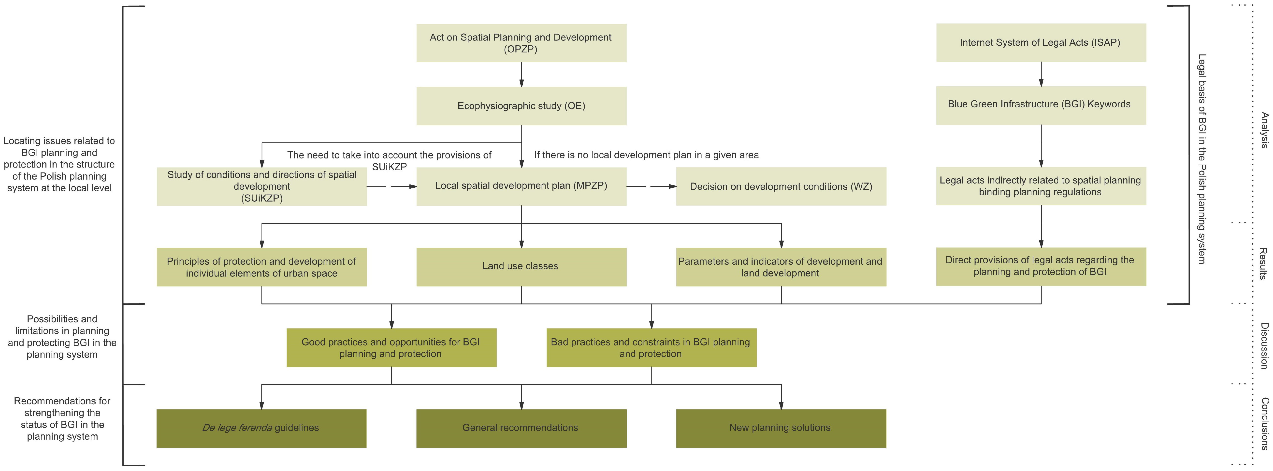
2. Materials and Methods

The research subject is the analysis of issues related to creating and protecting BGI facilities at the local level in the Polish planning system. The main problem is the lack of holistic tools for planning BGI elements on a local scale, which consists of several specific issues, including:
  • The absence of a full definition of BGI and ecosystem services in the Polish legal system;
  • The limited influence of the scientific community on the formation of BGIs;
  • The complexity of legal regulations relating to the protection of BGI;
  • The use of unreliable eco-physiographic studies in the development of the MPZP;
  • The non-obligatory nature of the MPZP for the entire municipality.
The research aims to find legal possibilities for shaping and protecting BGI in Poland by:
  • Selecting possible solutions that may function in the current legal status;
  • Suggesting new planning methods supporting the development of BGI masterplans;
  • Developing guidelines for amending certain legal acts to improve the current legal status.
The aim is to make planners and legislators aware of possible ways of increasing BGI in cities and to demonstrate the problems of planning practices and unfavorable legislative actions limiting the possibilities of BGI development and ecosystem services in Polish cities.
This study is an attempt to answer the following questions:
  • Are there legal tools to create BGI elements at the local level in Poland;
  • How can BGI be planned in Poland without acts of law directly regulating such activities;
  • How can the planning process be improved to consider the protection and creation of BGIs in Polish cities?
The scheme of the conducted research is presented in Figure 1.
The first stage of the research included an analysis of the Polish planning system and the legal empowerment of issues related to the possibility of planning and protecting BGIs. The time frame of the first research stage covers the legal status that is applicable until 24 September 2023. The analyses were aimed at location issues related to BGI planning and protection in the structure of the Polish planning system at the local level.
In the first part of the analysis, the available national and local legal acts database was analyzed to obtain the results. A set of keywords was used for various BGI elements: green areas, green roofs, green walls, trees, shrubs, parks, squares, boulevards, forests, cemeteries, allotment gardens, protected landscape areas, nature reserve areas, Nature 2000 sites, rivers, lakes, ponds, floodplains, flood risk, rainfall, buildings, roads, railways, biologically active surfaces, impervious surfaces, cultural heritage, monuments, ecosystems, building plots, and urban indicators. That made it possible to specify the legal acts that, indirectly, may introduce spatial planning regulations. As a result of the delimitation, detailed provisions of legal acts related to the planning and protection of BGI were determined. In the case of national legislation, the current acts and regulations were used, indicating their dispersion.
In the second part of the analysis, the Spatial Planning and Development Act (OPZP) was studied to describe the structure of the Polish planning system at the local level. The local development plan was selected as the only planning tool at the local level to enable the planning and protection of BGIs. These plans are currently the only pieces of legislation that impose specific restrictions on the location of individual land development elements and allow for the protection and shaping of BGI elements in existing and planned urban areas. Next, the possibilities of using the obligatory aspects of MPZP for the planning and protection of BGI were described. On the local scale, resolutions of the Poznań City Council introducing local spatial development plans were analyzed. This part gave a thorough explanation of how protection and development principles could be used for different parts of urban space, land use classes, parameters, and development indicators for planning and protecting BGI.
The second stage of the research involved the determination of possibilities and limitations in planning and protecting BGI in the planning system based on the results obtained. The discussion chapter confronted good practices and opportunities of planning for BGI protection and harmful practices and limitations in BGI planning and protection concerning the Polish planning system. The focus was on the issue of the lack of direct planning regulations for the creation of BGI masterplans. A problem was also highlighted concerning the functioning of the only planning tool enabling the planning and protection of BGI in Polish cities—the MPZP. Data on the greenery cover of urbanized areas and the share of current local spatial development plans in the country’s total area obtained from Statistics Poland and the Supreme Audit Office were used. In addition, urban planning indicators used in Poland and other European countries were compared to determine the most optimal solutions to suggest to the legislator.
The final stage of the research involved the creation of recommendations for strengthening the status of BGI in the planning system. To this end, we propose de lege ferenda guidelines concerning changes to the planning laws and acts, general recommendations to improve the current legal situation, and the possibility of introducing a new planning solution in the form of the UEQI indicator—Urban Ecosystem Quality Index.

3. Results

The Regulation of 17 December 2021 on the Scope of the Project Study of Conditions and Directions of Spatial Development of the Commune [14] and the Act of 27 March 2003 on Spatial Planning and Development [13] parallelly specify MPZP elements. Those subsidiary laws protect and develop blue-green infrastructure in numerous ways.

3.1. Land Use Classes

Legislator-designed land classes could use BGI. Instead, it is necessary to specify land use classes for which an increase in the area can considerably contribute to BGI development and protection [14].
The first category of land associated with BGI is agricultural land that has not been developed. The regulation subdivides the primary category into arable land, crops, meadows, and pastures. In the first case, despite the low biodiversity, cultivated areas are an essential component of surface vegetation that is biologically active (Figure 1). The legislator subsidizes the placement of ponds, open drainage and retention facilities, and protective tree lines on arable land, thereby increasing the frequency with which BGI facilities are included in this land use. In addition, energy crops (such as willow) and organic farming (such as permaculture or edible forest) can contribute to the ecological significance of these areas [20]. Meadows and pastures provide more ecosystem services than arable land. However, land management determines social benefits. For the infrastructure, meadows interspersed with thickets, trees, and water features will be of greater importance. The Act of 3 February 1995 on the Protection of Agricultural and Forest Land [21] protects agricultural BGI elements in Poland. According to Article 3(1), this protection includes: (1) limiting their use for non-agricultural or non-forestry purposes; (2) preventing degradation and devastation of agricultural land; (3) preventing damage to agricultural production caused by non-agricultural activities and mass land movements; (4) reclamation and development of land for agricultural purposes; (5) maintaining peatlands and ponds as natural water reservoirs; and (6) limiting changes in the natural forests. This class should be developed in the MPZP to protect the land from development without possibly adding other functions to the city.
The subsequent category, on water regions, was divided into regions of sea surface waters and inland surface waters. Aquatic ecosystems are a particular element of BGI. Water banks are one of the most biodiverse elements of the ecosystem, with a significant influence on the city’s microclimate and a substantial contribution to the city’s ecosystem services [22]. Increasing the area of water objects and, consequently, the city’s coastlines, is a crucial step in developing BGI (Figure 2). This land cover type is also legally protected. In Section III of the Act of 20 July 2017—Water Law [23]—the principles of water protection in both inland and marine surface waters are described in detail. The provisions of Section II, Chapter 9 of the Act of 21 March 1991 on Maritime Areas of the Republic of Poland and Maritime Administration [24] regulate the spatial planning and development of maritime areas of internal waters, territorial sea, and exclusive economic zones. Chapter 8 of the same Act outlines the principles of management in the coastal belt, which are also essential to BGI formation. Water is one of the most fundamental classes in BGI preservation and development. Therefore, it is necessary to increase its urban footprint gradually.
Forest areas can serve as the foundation of a city’s BGI. Unfortunately, most Polish forests exhibit the characteristics of typical productive forests. Consequently, their impact on the urban environment will be minimal compared to natural or ecologically restored forests. Ultimately, forests provide indispensable ecosystem services associated with biodiversity and microclimate. Within the meaning of the Act of 28 September 1991 on Forests, protective forests serve multiple ecological and sanitary functions [25]. They are primarily located within the administrative boundaries of cities and 10 km from the borders of cities with over 50,000 inhabitants. Chapter 2 of the Act of 3 February 1995 on the Protection of Agricultural and Forest Land [21] authorizes the incorporation of protective forests into the publicly accessible infrastructure. According to Article 9 of that Act, tourist equipment may be placed in areas of protective forests without a permit from the competent authority (Figure 3). However, the same article allows city managers to reduce the size of protective forests for social and land-related reasons. That may result in a decrease in urban forest areas. Article 3(2) of the preceding Act guarantees forest land protection. Its purpose is to: (1) limit the use of the forest for non-forest or non-agricultural functions; (2) prevent the processes of degradation and devastation of forest land; (3) prevent damage to forest stands and forest production caused by non-forest activities and mass land movements; (4) restore the use value of land that has lost its forest character as a result of non-forest activities; and (5) improve the use value of forests and prevent their deterioration. It is necessary to fight for the preservation and development of this function in the MPZP because, along with water areas, forests are the central core of the city’s BGI and provide the most significant number of ecosystem services.
The regulation divides green areas into natural, landscaped, allotment, and beach areas. All four classes protect and shape BGI. Green areas are areas with technical infrastructure, buildings functionally connected to them, vegetation, and public function, according to Article 5(21) of the Announcement of the Speaker of the Sejm of the Republic of Poland of 23 March 2022 on the Publication of the Consolidated Text of the Act on Nature Protection [26]. Green areas include parks, promenades, boulevards, botanical, zoological, and historic gardens, cemeteries, greenery along roads, squares, historic fortifications, buildings, landfills, airports, railway stations, and industrial facilities. Chapter 4’s law also protects that type of greenery. However, the legislator in the MPZP distinguishes green areas arranged with low and high greenery. Society will always prioritize tall vegetation due to its more significant impact on ecosystem services.
Polish law does not define natural green spaces. However, it can be assumed that the area contains wasteland and legally protected vegetation. Important ecological components of urban areas and wastelands constitute the fourth nature (Figure 4). Legally protected vegetation is the most valuable part of BGI due to its intricate morphology and its significant impact on the provision of ecosystem services. The Announcement of the Speaker of the Sejm of the Republic of Poland of 23 March 2022 on the Publication of the Consolidated Text of the Act on Nature Protection [26] strictly protects these objects, making it necessary to preserve and expand the land area associated with this land use category (Figure 5). Regulation of the Minister of Economic Development and Technology of 17 December 2021 on the Scope of the Project Study of Conditions and Directions of Spatial Development of the Commune [14] defines allotment gardens as public areas for organic food production and recreation. Allotment arbors are usually found in places with vegetation, water, or small retention facilities.
Additionally, the area surrounding the buildings is rarely paved. However, the development of allotment gardens becomes controversial when considering the types of facilities they contain [27]. Allotment gardens resemble single-family housing developments. The illegal use of allotment arbors throughout the year can be a significant source of regional emissions. Insufficient building insulation and the prevalence of such structures in family allotment gardens are problematic. Unfortunately, allotment gardens can be the primary source of winter anthropogenic heat emissions and environmental pollution, causing smog (Figure 6).
Additionally, allotment gardeners lease land, providing a small portion of ecosystem services to the public. Regulation of the Minister of Economic Development and Technology of 17 December 2021 on the Scope of the Project Study of Conditions and Directions of Spatial Development of the Commune [14] and the Polish Allotment Federation—Statute of Family Allotment Gardens—regulations [28] govern plot development. Due to their uncertain environmental impact and limited social impact, new allotment gardens should not be placed in city centers.
While maintaining vegetation and water facilities and removing buildings, BGI may benefit from transforming downtown allotment gardens into landscaped or natural green areas. In extreme cases, allotment gardens may be the only areas of greenery in urban areas. Due to the location of allotment gardens within the city, transforming them into public green spaces would benefit the urban population (Figure 7).
The Announcement of the Speaker of the Sejm of the Republic of Poland of 23 March 2022 on the Publication of the Consolidated Text of the Act on Nature Protection [26] classifies cemeteries as green regions, but the legislature has separated them in the MPZP. A graveyard can be active or closed. Well-developed cemetery greenery is an essential element of BGI in cities. Mature trees and shrubs in cemeteries shelter many animals. This object may improve the local microclimate and greenery system if the graveyard is densely vegetated. Including cemetery greenery in the above-mentioned legal acts implies the double protection of this type of BGI facility. Article 7 of the Regulation of the Minister of Infrastructure of 7 March 2008 on the Requirements to Be Met by Cemeteries, Graves and Other Places of Burial [29] specifies the need to consider insulating and decorative greenery in the entire cemetery area. That applies to lawns, hedges, shrubs, and trees. In addition, Chapter 4 of the Announcement of the Speaker of the Sejm of the Republic of Poland of 23 March 2022 on the Publication of the Consolidated Text of the Act on Nature Protection [26], which mainly regulates the felling of trees, applies to cemetery greenery as a category of green areas. Including cemetery vegetation in the legal acts implies that this type of BGI facility is afforded double protection. Article 7 of the Regulation of the Minister of Infrastructure of 7 March 2008 on the Requirements to Be Met by Cemeteries, Graves and Other Places of Burial [29] requires insulating and decorative vegetation throughout the cemetery, including lawns, hedges, bushes, and trees. In addition, Chapter 4 of the Announcement of the Speaker of the Sejm of the Republic of Poland of 23 March 2022 on the Publication of the Consolidated Text of the Act on Nature Protection [26] also applies to cemetery vegetation as a category of green areas.
Moreover, according to Article 6(1) of the Act of 31 January 1959 on Cemeteries and Burial of the Deceased [30], the area of a closed cemetery may be used for another purpose forty years after the cemetery’s closure and final interment. Due to the dense tree cover, these areas are typically designated as green areas with tall vegetation (Figure 8). Cemetery vegetation is protected twice as a component of BGI, which is a strong argument in favor of including this function in the MPZP.
Technical infrastructure related to drinking water abstraction (often located within the city’s administrative boundaries, but not always) can also form an extensive base of water facilities in the town (Figure 9). Supply and regulatory ecosystem services may depend on them [31]. The 20 July 2017, Chapter 6 of the Act of 20 July 2017—Water Law—protects water intakes [23]. Water intakes (Figure 10) are usually fenced to keep residents out. They have no social value despite lowering city temperatures and supporting biodiversity.

3.2. Protection and Development Principles

Article 71 of the Act of 27 April 2001—Environmental Protection Law [17]—establishes BGI protection principles in the MPZP. It mentions the need to base the provisions of the MPZP on the principles of sustainable development and environmental protection. Thus, the MPZP details pollution emission prevention, land and water pollution protection, and contaminated area reclamation. The MPZP’s land use and development plan should protect a municipality’s landscape value. Article 72 of the same Act specifies environmental protection requirements that must be considered in the MPZP. Maintaining the natural balance and rational management of the commune’s environmental resources are to be ensured by: (1) establishing programs for rational management and use of land; (2) creating comprehensive solutions to the problems of urban and rural development, emphasizing water management and arranging and shaping green areas; (3) considering the need to protect water and soil against pollution; and (4) protecting landscape values, the environment, and climatic conditions. It is also necessary to refer to an eco-physiographic study, which includes fundamental information about the state of the environment and the distribution of natural elements in the MPZP plan area.
Putting specific restrictions on the location of different parts of land development and allowing certain elements to be built in certain places is allowed by the MPZP. This protects and shapes BGI elements in both existing and planned urban areas, as shown by the MPZP designed in Poznań in 2022 [32,33,34,35,36,37,38,39,40,41,42,43].
  • To protect and shape the spatial order and landscape, it is necessary to develop the BGI to decide, for instance: (1) the specific location of functional green zones, including greenery accompanying buildings; (2) the minimum biologically active area of car parks, along with the height of trees and shrubs to be planted on their premises; (3) a ban on large-scale development or other infrastructure that impacts the landscape; (4) prohibition of obscuring fences; (5) maximum crossings of the building line for facades covered with greenery—located above the ground floor; (6) the need to develop communication routes with high greenery in case of the location of commercial facilities above a specific area; (7) a ban on the location of building elements—including buildings—in specific green zones; (8) the possibility of locating small architecture objects in a given function; and (9) the possibility of locating outdoor sports and recreation equipment, sports fields, playgrounds, and games;
  • In the context of environmental, nature, and cultural landscape protection, it may be essential for the development of BGI to: (1) preserve and protect existing valuable greenery, including trees; (2) order to locate insulating greenery; (3) preserve and supplement existing trees and shrubs; (4) indicate a possibility of replanting trees or compensating for felled trees; (5) order to develop greenery of all unpaved spaces; (6) protect the landscape values in green areas through maintenance of existing use, including protection of surface waters and natural plant communities; (7) permit new tree plantings in the road lane—provided there is no conflict with road parameters and technical infrastructure; (8) allow plantings on railway areas, ensuring railway traffic safety; (9) preserve open watercourses, ditches, and reservoirs; (10) allow the placement of facilities and devices for retention or management of rainwater and meltwater, including infiltration ditches, drains, retention reservoirs, rain gardens, hydrophyte ponds, absorbent wells, and green roofs and walls; (11) permit the use of permeable and semi-permeable surfaces for hardening accesses, pedestrian and bicycle routes; as well as (12) indicate the maximum height of trees to expose an architectural object;
  • In the context of specific land development conditions and restrictions on their use, the BGI development may need to determine, for example: (1) the need to take into account the requirements and restrictions resulting from the vicinity of the forest in the development of the site; (2) taking into account the development restrictions resulting from the location in the area of particular flood risk—following separate provisions regarding flood risk; (3) a ban on the location of buildings in floodplains; (4) a ban on changing the terrain into green areas affecting flood water flow; (5) the need to take into account the requirements and limitations resulting from the course of the technical infrastructure network when planting new trees; (6) the need to take into account the specific development conditions and restrictions resulting from the location near the railway area; and (7) maintaining the continuity of the existing drainage system to allow its reconstruction;
  • BGI development may need to consider developing unpaved road strip surfaces with arranged greenery, such as trees, shrubs, lawns, and flowerbeds, to shape public spaces;
  • Finally, in the context of protecting cultural heritage, monuments, and contemporary cultural goods, BGI development may need to determine the necessity of, for example: (1) preserving trees protected by the plan—with the possibility of supplementing trees and preserving other trees—which are part of the protected area’s composition; (2) preserving the body, composition, and articulation of the façade, characteristic façade divisions, architectural details, shape, angle of inclination, and type of roofing in the registered building; (3) preserving the park under conservation protection, including restoration of historical development; (4) preserving the terrain associated with the registered buildings; and (5) preserving the original, historical paving surface.
The MPZP also mandates development methods for protected areas; the Act of 23 July 2003 on the Protection and Care of Monuments limits monument protection, including historic greenery [44]. The Act of 16 April 2004 on Nature Protection [45] restricts the protection of national parks, nature reserves, landscape parks, protected landscape areas, Nature 2000 sites, natural and landscape complexes, documentation sites, natural monuments, and their buffer zones. The Act of 20 July 2017—Water Law—[23] must be followed when using water catchment areas and establishing protection zones for water intakes and inland reservoirs. In most cases, such arrangements can protect valuable natural elements, which form the city’s BGI and, with rational spatial management, can affect municipalities’ ecosystem services.

3.3. Parameters and Indicators of Buildings and Land Development

The MPZP mandates urban indicators. The most important of them, from the point of view of BGI, is the Biologically Active Surface Index (PBC). It is the only legal basis for planning BGI sites on private plots. Only §3 of the Announcement of the Minister of Economic Development and Technology of 15 April 2022 on the Technical Conditions to Be Met by Buildings and Their Location defines a PBC [46]. The legislator defines the biologically active surface as an area with a surface set up to support natural vegetation of plants and rainwater retention, as well as 50% of the surface of roofs and terraces that support natural vegetation (with an area of at least 10 m2) and surface water in this area. This parameter sets the minimum undeveloped plot area for BGI. Any vegetated or watered area over 10 m2 may be classified as biologically active. Green roofs and green walls are also acceptable. According to §39 of the ordinance, at least 25% of multi-family housing and healthcare building plots, excluding clinics, education, and upbringing buildings, must be greenery, water facilities, or hybrid solutions (e.g., porous surfaces). §40 requires playground greenery to be 30% of biologically active areas. The MPZP must be followed when developing this space. In any other context, each land use class in a local development area determines its minimum indicator of biological activity. The MPZP developed in 2022 in Poznań includes 38% of biologically active sites in all urban areas [32,33,34,35,36,37,38,39,40,41,42,43]. In the ecological crisis, despite its vital importance, the PBC seems inadequate for city BGI planning. PBCs only consider the retention value of the investment site, not microclimate or biodiversity, which limits BGI planning in the city and reduces the likelihood of providing essential ecosystem services to its residents. Pathology may also result from completely removing greenery and water objects from plots in favor of porous surfaces or green roofs as biologically active areas that meet water retention conditions.
Building area and intensity are other MPZP urban indicators that affect city BGI. The vertical projection determines the plot’s minimum and maximum building areas. The second defines the minimum and maximum building intensity, or the ratio of building area to building plot area. These indicators protect land-use-class nature from development. In both cases, limiting building intensity and area will defend as much BGI land as possible in the MPZP. However, a biologically active area that is too small may make such sites endangered, limiting their protection. When using openwork surfaces to preserve the biologically active area, the urban indicators may not affect BGI component protection, which is a legal paradox.

4. Discussion

Polish law favors the city’s blue-green infrastructure but hinders its planning. The complexity and number of legal issues to consider without developing holistic planning tools enabling data collection and the creation of BGI masterplans slow the process of regenerative city development in Poland [47,48] and limit urban ecosystem protection.
Planning documents on the local level in Poland often obey or treat the issue of ecosystem services selectively [49]. Even though academia has widely recognized the concept within the last decades [50,51], it is used in several strategic documents by the European Union [52]. Nevertheless, there are differences in how member states have adopted the concept of ecological services in their legislation. Although there are different ways of understanding ecosystem services, the European Union defines it as the services that an ecosystem supplies and on which humans depend [53]. In this respect, BGI is widely represented in EU documents and seen as supporting ecosystem services under the category of regulation services. BGI can contribute to reducing the heat in urban areas, protecting natural resources, reducing flood risk, and improving people’s general comfort.
Research by Davies and Lafortezz (2017) [54] indicates a lack of coherence in strategic documents relating to BGI. The study was conducted in 20 European cities. Regarding the transparency and consistency of planning documents, the worst situation was noticed in countries such as Hungary, Slovenia, Romania, and Poland. Our research demonstrates the inconsistency of Polish regulations, which supports this. In India, attempts are being made to unify the law (administrative changes) and adapt its provisions to the changing climate [55]. At the same time, it is impossible to introduce the most straightforward solutions in Poland (e.g., concerning BGI) to minimize adverse climate change. The lack of transparent BGI planning tools influencing the UHI effect was particularly highlighted in France in 2013 [56]. Since then, following the example of other countries that have already introduced such policies, several regulations relating to BGI have been created in France. A good example is the United Kingdom, which adopted a Green Infrastructure Strategy in 2006 [57], which laid the groundwork for regulatory changes to introduce BGIs. Research conducted by Deely et al. (2020) [58], as well as Haaland and van den Bosch (2015) [59], also draws attention to the problems associated with the implementation of BGI solutions in urban structures.
Only MPZP can protect and create BGI in Poland. According to Statistics Poland data, 20.51% of the country’s total area is covered by current local plans [60]. The municipality is not required to adopt the MPZP. However, establishing a local plan for individual city areas may be required for: (1) creating a protected landscape area [45]; (2) establishing a cultural park [44]; (3) allocating agricultural and forest areas for investment activities [21]; and (4) consolidating or dividing real estate and shaping public space [13]. The MPZP does not need to cover most of the city’s strategic natural infrastructure, which is one of the major problems regarding the development of BGI in Poland.
Administrative decisions use plot-specific development conditions (WZ) when the MPZP does not cover the municipality. Incompetent officials, bureaucratic barriers to creating the MPZP, and high investment pressure can make the WZ a tool for environmental pathologies [61,62,63]. The WZ lacks binding BGI formation and protection provisions because it does not need to match SUiKZP. Thus, valuable natural areas that provide ecosystem services are built up. However, the lack of administrative intervention in MPZP development seems to be the biggest issue. WZ decisions can only be delayed for nine months. This period is often too short to develop MPZP, resulting in a WZ decision.
Managing green areas should increase BGI facilities’ surface area and quality in urban spaces [64,65,66]. Despite MPZP issues, Polish cities are greening. Statistics Poland reported 221.5 ha of new green areas in 2022. Kraków purchased the most land, increasing its BGI by 96.3 ha. However, 53% of 180 WZ decisions in the same city allowed buildings in environmentally and infrastructurally significant areas. WZs often lack a minimum biologically active surface area index [67]. For this reason, the lack of coverage of the entire municipality with local plans is the main problem for BGI planning and protection in Polish cities, especially in the context of ensuring ecological corridor connectivity, which the legislator considers the basis of the BGI in Poland.

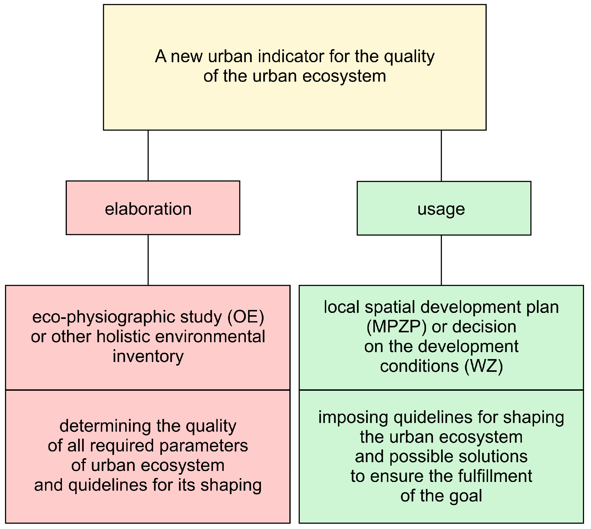
New Polish Urban Index

The recent scientific problem is finding a universal model for building cities’ resilience to climate change. The assessment of urban development and the role of BGI are two of the most crucial research interests concerning mitigation and urban adaptation to climate change [68]. Some studies show that, to plan BGIs optimally and effectively, developing a data management system that connects administrative sectors and scientific disciplines in which citizens can participate is necessary [69]. Without a proper multifunctional data platform and transparent legal regulations, planning BGI facilities will be challenging.
An important aspect is developing a unified and optimal indicator for cities considering BGI. The Polish planning system’s Biologically Active Area Index is essential for climate change resilience and biodiversity. This indicator does not seem to meet its primary goals in the current environmental crisis, especially in the context of BGI quality regulation on private plots. This problem can be solved by creating a new urban indicator with greater parametric complexity and impact on natural environment protection. Such a solution, defining the multitude of guidelines needed to meet the guidelines resulting directly from ecosystem information used in urban plans and development conditions, can affect BGI behavior and development in Polish cities.
Several good urban indicators work, like the Polish Biologically Active Area Index, but are more complex and impactful for BGI planning. The Berlin Biotope Area Factor (BAF) is similar to the Polish equivalent but includes all vegetation with a quality conversion factor [70]. The Malmö Green Space Factor (GF) is another option [71]. This indicator uses BAF but includes tree and shrub coverage. The Seattle Green Factor (SGF) is more advanced [72]. It has 21 parameters concerning: (1) types of green roofs; (2) types of paving materials used; (3) land use for food production; (4) rainwater retention and storage potential; and (5) use of specific plant species. The number of parameters considered in developing indicators still seems too small in light of the global civilization crisis.
It is necessary to create a holistic tool for evaluating the quality of the urban ecosystem in terms of the quantity and quality of ecosystem services provided. Including ecosystem services in the planning phase will help bring about beneficial changes in the urban environment, such as reducing the cost of municipal services, developing the local economy, and improving the quality of life, especially in the face of climate change. The introduction of a simplified policy for the management of urban ecosystem services seems to be a smart solution to the problem of deterioration of the quality of the urban ecosystem and the planning and assessment of the ecosystem in urban areas. A few advanced indexes have been developed (Table 1) based on various groups of predictors. However, their problems often turn out to be: (1) a broad approach to the subject (not focusing on environmental aspects); (2) low precision of scale; (3) imprecise research data; (4) inability to assess cities; (5) inability to set detailed spatial guidelines; and (6) prediction of changes in the urban ecosystem.
Polish BGI inventories and database updates are rare [67]. This type of inventory should be part of an MPZP-commissioned eco-physiographic study, which would significantly improve the city’s natural element database. Municipalities must update eco-physiographic studies at the current rate of environmental degradation. Additionally, eco-physiographic studies should be simplified (e.g., measured remotely) to create an extensive database with precise and up-to-date information on each municipality’s urban ecosystem quality.
The pace of transformation in the city requires the creation of accurate databases and analytical tools to assess their impact on ecosystems. It seems reasonable to base the calculation of the ecosystem quality index on readily available and precise data. GIS and GPS are important in monitoring, mapping, and evaluating land cover dynamics in urban environments. GIS is used to build, analyze, and present spatial data that can be helpful in environmental decision-making [73,74,75]. Creating an indicator based on remote sensing data will allow it to be used by city managers in the field of precise spatial planning. Thus, it will contribute to building resilience to climate change and improving the quality-of-life in Polish cities.

5. Conclusions

Due to the high frequency of regulation changes, our research is characterized by the time limitation of its validity. Still, they can be recommendations supported by in-depth analyses. The methodology used in the study can be successfully used to update the legal status of BGI planning and protection issues in the Polish legal system at the local level.
Despite adopting sustainable development as a determinant, Polish spatial planning laws have yet to define BGI and the ecosystem services they provide. Thus, BGI’s ability to protect the city’s climate and quality-of-life still needs to be explored. The main reason is the lack of legal instruments requiring municipalities and investors to preserve and develop BGI. Despite many changes and possible solutions, the system seems inefficient, and only legal planning document regulations can improve it.
Planners, using the obligatory elements of the MPZP, can design BGI without using specially designed regulations. However, this is only partially possible. These legal tools allow for creating and protecting BGIs within the MPZP area. However, this does not solve the problem of planning BGI outside the areas covered by the MPZP, which constitute the vast majority of Poland.
It is necessary to amend the provisions of Article 14.7. of the Spatial Planning and Development Act [13] to eliminate the conditionality of the development of the MPZP in the commune. This provision should read as follows: “A local plan shall be drawn up for the entire area of the commune”. By doing this, the MPZP will have to cover the entire municipality, preventing environmental pathologies brought on by the issuance of the WZ and assisting in the development of BGI masterplans.
Efforts should be made to implement the definition of BGI and ecosystem services directly into regulations such as the MPZP. Emphasizing the desirability of covering the entire area of the municipality with MPZP for the creation of a BGI masterplan in the region of the municipality, Article 1.2 of the Spatial Planning and Development Act [13] should be supplemented with the provision, “Planning of blue-green infrastructure as a strategically planned network of natural and semi-natural areas with other environmental features, designed and managed to provide a wide range of ecosystem services while enhancing biodiversity.” A catalog of ecosystem services based on the definition taken from the legal system of the European Union should be attached as an appendix to the Act.
Article 6.1. of the Act of 16 April 2004 on Nature Protection [45] should be supplemented with a new type of legally protected area: urban nature reserves, which, located in strategic points of the city, may help BGI development. These areas could be cool city islands and water and biodiversity reservoirs. These solutions would improve city sanitation by providing the urban community with as many ecosystem services as possible. Allotment gardens in densely built-up areas can be used to create reserves. Urban nature parks should have food-producing areas to avoid social conflicts. Land management and leasing should be optimized. In this way, protecting areas with the highest potential for ecosystem services from development at the MPZP level will be possible.

Future Research Directions

Future research on BGI planning in Polish cities should explore the possibility of developing and implementing a new pro-ecological urban indicator into planning documents to define the urban ecosystem and provide guidelines for creating and changing urban space patterns to improve it.
This indicator should aim to present the current resilience of a given urban space to climatic conditions and extreme events, the quality of the ecosystem, and urban space in the sense of public health. In addition, it should enable the simulation of future scenarios of changes in the urban ecosystem, thus helping to prevent crises, plan mitigation and adaptation to climate change, and build the resilience of the urban community through the development of blue-green spaces (BGS) in cities and ensuring the proper functioning of urban ecosystems. The model should be based on knowledge of the individual classes: (1) water; (2) soil; (3) air; (4) microclimate; (5) biodiversity; and (6) the site function and space, as many detailed parameters as possible for the given classes. Such a detailed model will also make it possible to set precise guidelines for changes in given urban units to avoid the formation of crisis areas related to, for example, flooding, droughts, urban heat island, loss of biodiversity, and environmental injustice.
Moreover, the objective of the new indicator should be to reduce the need for field studies when stakeholders calculate the index. To date, such a precise, and at the same time accessible to the general public, tool for identifying and simulating the urban ecosystem has not been developed. Data for developing the indicator should be obtained using remote sensing technology and field research. Getting data from the field will increase the model’s reliability by verifying data measured remotely. Reducing the need for field research will increase the availability of the method and the transfer of knowledge to the economy and the planning environment in Poland.
Local administrative law should require such an indicator for transparent and uniform spatial policy (Figure 11). It should be introduced in place of the PBC indicator in the MPZP. It would allow the creation of BGI masterplans, control urban environment quality in terms of sanitation, and build the ecosystem-based resilience of Polish cities to climate change and extreme weather events, significantly impacting towns in the Wielkopolska region [76,77]. Moreover, some applications could have a positive impact on reducing the outflow and decreasing environmental degradation [78].

Author Contributions

Conceptualization P.A.; Formal analysis P.A. and D.Ś.; Investigation P.A., D.Ś., M.K. and A.C.; Methodology P.A. and M.K.; Supervision P.A. and D.Ś.; Validation P.A. and D.Ś.; Visualization P.A. and M.K.; Writing—original draft P.A. and M.K.; Writing—review & editing P.A., M.K. and A.C.; Funding acquisition A.C. and M.K. All authors have read and agreed to the published version of the manuscript.

Funding

This research was funded by THE NATIONAL SCIENCE CENTRE OF POLAND, grant number 2022/47/D/HS4/01313 (A.C. and M.K.).

Institutional Review Board Statement

Not applicable.

Informed Consent Statement

Not applicable.

Data Availability Statement

Data are contained within the article.

Conflicts of Interest

The authors declare no conflict of interest.

Abbreviations

BGIBlue-Green Infrastructure
UHIUrban Heat Island
MPZPLocal Spatial Development Plan (Miejscowy Plan Zagospodarowania Przestrzennego)
WZDevelopment Conditions (Warunki Zabudowy)
NBSNature-Based Solutions
ESEcosystem Services
SUiKZPMunicipal Spatial Development Plan (Studium Uwarunkowań i Kierunków Zagospodarowania Przestrzeni)
NGONon-Governmental Organization
OPZPSpatial Planning and Development Act (Ustawa o Planowaniu i Zagospodarowaniu Przestrzennym)
UEQIUrban Ecosystem Quality Index
PBCBiologically Active Surface Index (Wskaźnik Powierzchni Biologicznie Czynnej)
BAFBerlin Biotope Area Factor
GFMalmö Green Space Factor
SGFSeattle Green Factor
EPIEnvironmental Performance Index
ERIEnvironmental Resilience Index
EQIEnvironmental Quality Index
UERIUrban Ecosystem Resilience Index
CRICity Resilience Index
CDRIClimate Disaster Resilience Index
GISGeographic Information System
GPSGlobal Positioning System
BGSBlue-Green Spaces
OEEco-physiographic Study (Opracowanie Ekofizjograficzne)

References

  1. Göpfert, C.; Wamsler, C.; Lang, W. A Framework for the Joint Institutionalization of Climate Change Mitigation and Adaptation in City Administrations. Mitig. Adapt. Strateg. Glob. Chang. 2019, 24, 1–21. [Google Scholar] [CrossRef] [PubMed]
  2. Raymond, C.M.; Frantzeskaki, N.; Kabisch, N.; Berry, P.; Breil, M.; Nita, M.R.; Geneletti, D.; Calfapietra, C. A Framework for Assessing and Implementing the Co-Benefits of Nature-Based Solutions in Urban Areas. Environ. Sci. Policy 2017, 77, 15–24. [Google Scholar] [CrossRef]
  3. Shen, J.; Peng, Z.; Wang, Y. From GI, UGI to UAGI: Ecosystem Service Types and Indicators of Green Infrastructure in Response to Ecological Risks and Human Needs in Global Metropolitan Areas. Cities 2023, 134, 104176. [Google Scholar] [CrossRef]
  4. Reid, W.V.; Mooney, H.A.; Cropper, A.; Capistrano, D.; Carpenter, S.R.; Chopra, K.; Dasgupta, P.; Dietz, T.; Duraiappah, A.K.; Hassan, R. Ecosystems and Human Well-Being-Synthesis: A Report of the Millennium Ecosystem Assessment; Island Press: Washington, DC, USA, 2005; ISBN 1-59726-040-1. [Google Scholar]
  5. Ghofrani, Z.; Sposito, V.; Faggian, R. A Comprehensive Review of Blue-Green Infrastructure Concepts. Int. J. Environ. Sustain. 2017, 6, 15–36. [Google Scholar] [CrossRef]
  6. Kumar, P. The Economics of Ecosystems and Biodiversity: Ecological and Economic Foundations; Routledge: London, UK, 2012; ISBN 1-136-53879-8. [Google Scholar]
  7. Maltby, E.; Acreman, M.C. Ecosystem Services of Wetlands: Pathfinder for a New Paradigm. Hydrol. Sci. J. 2011, 56, 1341–1359. [Google Scholar] [CrossRef]
  8. Hasan, S.S.; Zhen, L.; Miah, M.G.; Ahamed, T.; Samie, A. Impact of Land Use Change on Ecosystem Services: A Review. Environ. Dev. 2020, 34, 100527. [Google Scholar] [CrossRef]
  9. Guerry, A.D.; Polasky, S.; Lubchenco, J.; Chaplin-Kramer, R.; Daily, G.C.; Griffin, R.; Ruckelshaus, M.; Bateman, I.J.; Duraiappah, A.; Elmqvist, T.; et al. Natural Capital and Ecosystem Services Informing Decisions: From Promise to Practice. Proc. Natl. Acad. Sci. USA 2015, 112, 7348–7355. [Google Scholar] [CrossRef] [PubMed]
  10. Marando, F.; Salvatori, E.; Sebastiani, A.; Fusaro, L.; Manes, F. Regulating Ecosystem Services and Green Infrastructure: Assessment of Urban Heat Island Effect Mitigation in the Municipality of Rome, Italy. Ecol. Model. 2019, 392, 92–102. [Google Scholar] [CrossRef]
  11. Act 25 Resolution of the Council of Ministers of November 6, 2015 on the Approval of the “Programme for the Conservation and Sustainable Use of Biological Diversity along with the Action Plan for 2015–2020” (Uchwała Rady Ministrów z 6.11.2015 w Sprawie Zatwierdzenia “Programu Ochrony i Zrównoważonego Użytkowania Różnorodności Biologicznej Wraz z Planem Działań Na Lata 2015–2020”). Available online: https://isap.sejm.gov.pl/isap.nsf/DocDetails.xsp?id=WMP20150001207 (accessed on 27 March 2023).
  12. Redakcja Czasopisma RRPR. Usługi ekosystemowe w zarządzaniu układami przyrodniczymi. Rozw. Reg. Polityka Reg. 2023, 168–169. [Google Scholar] [CrossRef]
  13. Act 6 Act of March 27, 2003 on Spatial Planning and Development (Ustawa z 27.03.2003 o Planowaniu i Zagospodarowaniu Przestrzennym). Available online: https://isap.sejm.gov.pl/isap.nsf/DocDetails.xsp?id=wdu20030800717 (accessed on 27 March 2023).
  14. Act 27 Regulation of the Minister of Economic Development and Technology of December 17, 2021 on the Scope of the Project Study of Conditions and Directions of Spatial Development of the Commune (Rozporządzenie Ministra Rozwoju i Technologii z 17.12.2021 w Sprawie Zakresu Projektu Studium Uwarunkowań i Kierunków Zagospodarowania Przestrzennego Gminy). Available online: https://isap.sejm.gov.pl/isap.nsf/DocDetails.xsp?id=WDU20210002405 (accessed on 27 March 2023).
  15. Sabura, K.; Oleszek, J.; Szkaradkiewicz, M.; Kazak, J. Udział społeczeństwa w ochronie zieleni na obszarach innych niż leśne (Citizen Participation in Greenery’s Preservation in the Areas Other than Forest). Infrastrukt. Ekol. Teren. Wiej. 2014, 657–665. [Google Scholar] [CrossRef]
  16. Świdyński, J.; Świdyńska, N.K. Konsultacje Społeczne jako Narzędzie Współpracy Obywateli z Samorządem Gminnym na Przykładzie Olsztyna (Public Consultation as a Tool of Cooperation of Citizens with Local Municipality on Example of Olsztyn); Wydawnictwo Uniwersytetu Ekonomicznego we Wrocławiu: Wroclaw, Poland, 2016. [Google Scholar]
  17. Act 7 Act of April 27, 2001—Environmental Protection Law (Ustawa z 27.04.2001—Prawo Ochrony Środowiska). Available online: https://isap.sejm.gov.pl/isap.nsf/DocDetails.xsp?id=wdu20010620627 (accessed on 27 March 2023).
  18. Act 26 Regulation of the Minister of the Environment of September 9, 2002 on Eco-physiographic Studies (Rozporządzenie Ministra Środowiska z 9.09.2002 w Sprawie Opracowań Ekofizjograficznych). Available online: https://isap.sejm.gov.pl/isap.nsf/DocDetails.xsp?id=WDU20021551298 (accessed on 27 March 2023).
  19. Korwel-Lejkowska, B.; Szlachetko, J. Opracowanie ekofizjograficzne w planowaniu przestrzennym jako przesłanka zrównoważonego rozwoju (An ecophysiographic study in area planning and development as the basis of balanced development). Prawo 2015, 318, 95–103. [Google Scholar]
  20. Tamburini, G.; Bommarco, R.; Wanger, T.C.; Kremen, C.; van der Heijden, M.G.A.; Liebman, M.; Hallin, S. Agricultural Diversification Promotes Multiple Ecosystem Services without Compromising Yield. Sci. Adv. 2020, 6, eaba1715. [Google Scholar] [CrossRef] [PubMed]
  21. Act 12 Act of February 3, 1995 on the Protection of Agricultural and Forest Land (Ustawa z 3.02.1995 o Ochronie Gruntów Rolnych i Leśnych). Available online: https://isap.sejm.gov.pl/isap.nsf/DocDetails.xsp?id=wdu19950160078 (accessed on 27 March 2023).
  22. Khan, I.; Zhao, M. Water Resource Management and Public Preferences for Water Ecosystem Services: A Choice Experiment Approach for Inland River Basin Management. Sci. Total Environ. 2019, 646, 821–831. [Google Scholar] [CrossRef] [PubMed]
  23. Act 1 Act of July 20, 2017—Water Law (Ustawa z 20.07.2017—Prawo Wodne). Available online: https://isap.sejm.gov.pl/isap.nsf/DocDetails.xsp?id=WDU20170001566 (accessed on 6 June 2023).
  24. Act 9 Act of March 21, 1991 on Maritime Areas of the Republic of Poland and Maritime Administration (Ustawa z 21.03.1991 o Obszarach Morskich Rzeczypospolitej Polskiej i Administracji Morskiej). Available online: https://isap.sejm.gov.pl/isap.nsf/DocDetails.xsp?id=wdu19910320131 (accessed on 27 March 2023).
  25. Act 5 Act of September 28, 1991 on Forests (Ustawa z 28.09.1991 o Lasach). Available online: https://isap.sejm.gov.pl/isap.nsf/DocDetails.xsp?id=wdu19911010444 (accessed on 27 March 2023).
  26. Act 29 Announcement of the Speaker of the Sejm of the Republic of Poland of March 23, 2022 on the Publication of the Consolidated Text of the Act on Nature Protection (Obwieszczenie Marszałka Sejmu Rzeczypospolitej Polskiej z 23.03.2022 w Sprawie Ogłoszenia Jednolitego Tekstu Ustawy o Ochronie Przyrody). Available online: https://isap.sejm.gov.pl/isap.nsf/DocDetails.xsp?id=WDU20220000916 (accessed on 5 May 2023).
  27. Sowińska-Świerkosz, B.; Michalik-Śnieżek, M.; Bieske-Matejak, A. Can Allotment Gardens (AGs) Be Considered an Example of Nature-Based Solutions (NBS) Based on the Use of Historical Green Infrastructure? Sustainability 2021, 13, 835. [Google Scholar] [CrossRef]
  28. Act 2 Polish Allotment Federation—Statute of Family Allotment Gardens (Polski Związek Działkowców—Regulamin). Available online: http://pzd.pl/regulamin.html (accessed on 6 June 2023).
  29. Act 28 Regulation of the Minister of Infrastructure of March 7 2008 on the Requirements to Be Met by Cemeteries, Graves and Other Places of Burial (Rozporządzenie Ministra Infrastruktury z 7.03.2008 w Sprawie Wymagań, Jakie Muszą Spełniać Cmentarze, Groby i Inne Miejsca Pochówku Zwłok i Szczątków). Available online: https://isap.sejm.gov.pl/isap.nsf/DocDetails.xsp?id=WDU20080480284 (accessed on 27 March 2023).
  30. Act 4 Act of January 31, 1959 on Cemeteries and Burial of the Deceased (Ustawa z 31.01.1959 o Cmentarzach i Chowaniu Zmarłych). Available online: https://isap.sejm.gov.pl/isap.nsf/DocDetails.xsp?id=WDU19590110062 (accessed on 27 March 2023).
  31. Bartosik, A.; Chomicki, J.; Jankowski, T. Zmiana jakości wody powierzchniowej podczas infiltracji na przykładzie ujęcia “Dębina” w Poznaniu (Variations in surface water quality during infiltration: A case study). Ochr. Śr. 2007, 29, 51–54. [Google Scholar]
  32. Act 13 Resolution of the Poznań City Council No. LXXIII/1341/VIII/2022 of November 8, 2022 (Uchwała Nr LXXIII/1341/VIII/2022 z 8.11.2022). Available online: https://bip.poznan.pl/bip/uchwaly/lxxiii-1341-viii-2022-z-dnia-2022-11-08,89060/ (accessed on 27 March 2023).
  33. Act 14 Resolution of the Poznań City Council No. LXXIII/1340/VIII/2022 of November 8, 2022 (Uchwała Nr LXXIII/1340/VIII/2022 z 8.11.2022). Available online: https://bip.poznan.pl/bip/uchwaly/lxxiii-1340-viii-2022-z-dnia-2022-11-08,89059/ (accessed on 27 March 2023).
  34. Act 15 Resolution of the Poznań City Council No. LXXIII/1339/VIII/2022 of November 8, 2022 (Uchwała Nr LXXIII/1339/VIII/2022 z 8.11.2022). Available online: https://bip.poznan.pl/bip/uchwaly/lxxiii-1339-viii-2022-z-dnia-2022-11-08,89058/ (accessed on 27 March 2023).
  35. Act 16 Resolution of the Poznań City Council No. LXIX/1243/VIII/2022 of July 12, 2022 (Uchwała Nr LXIX/1243/VIII/2022 z 12.07.2022). Available online: https://bip.poznan.pl/bip/uchwaly/lxix-1243-viii-2022-z-dnia-2022-07-12,88098/ (accessed on 27 March 2023).
  36. Act 17 Resolution of the Poznań City Council No. LXIX/1242/VIII/2022 of July 12, 2022 (Uchwała Nr LXIX/1242/VIII/2022 z 12.07.2022). Available online: https://bip.poznan.pl/bip/uchwaly/lxix-1242-viii-2022-z-dnia-2022-07-12,88097/ (accessed on 27 March 2023).
  37. Act 18 Resolution of the Poznań City Council No. LXIV/1181/VIII/2022 of May 17, 2022 (Uchwała Nr LXIV/1181/VIII/2022 z 17.05.2022). Available online: https://bip.poznan.pl/bip/uchwaly/lxiv-1181-viii-2022-z-dnia-2022-05-17,87558/ (accessed on 27 March 2023).
  38. Act 19 Resolution of the Poznań City Council No. LXIV/1180/VIII/2022 of May 17, 2022 (Uchwała Nr LXIV/1180/VIII/2022 z 17.05.2022). Available online: https://bip.poznan.pl/bip/uchwaly/lxiv-1180-viii-2022-z-dnia-2022-05-17,87557/ (accessed on 27 March 2023).
  39. Act 20 Resolution of the Poznań City Council No. LXIII/1166/VIII/2022 of April 26, 2022 (Uchwała Nr LXIII/1166/VIII/2022 z 26.04.2022). Available online: https://bip.poznan.pl/bip/uchwaly/lxiii-1166-viii-2022-z-dnia-2022-04-26,87358/ (accessed on 27 March 2023).
  40. Act 21 Resolution of the Poznań City Council No. LX/1121/VIII/2022 of March 8, 2022 (Uchwała Nr LX/1121/VIII/2022 z 8.03.2022). Available online: https://bip.poznan.pl/bip/uchwaly/lx-1121-viii-2022-z-dnia-2022-03-08,86918/ (accessed on 27 March 2023).
  41. Act 22 Resolution of the Poznań City Council No. LX/1120/VIII/2022 of March 8, 2022 (Uchwała Nr LX/1120/VIII/2022 z 8.03.2022). Available online: https://bip.poznan.pl/bip/uchwaly/lx-1120-viii-2022-z-dnia-2022-03-08,86917/ (accessed on 27 March 2023).
  42. Act 23 Resolution of the Poznań City Council No. LIX/1094/VIII/2022 of February 15, 2022 (Uchwała Nr LIX/1094/VIII/2022 z 15.02.15). Available online: https://bip.poznan.pl/bip/uchwaly/lix-1094-viii-2022-z-dnia-2022-02-15,86678/ (accessed on 27 March 2023).
  43. Act 24 Resolution of the Poznań City Council No. LIX/1093/VIII/2022 of February 15, 2022 (Uchwała Nr LIX/1093/VIII/2022 z 15.02.2022). Available online: https://bip.poznan.pl/bip/uchwaly/lix-1093-viii-2022-z-dnia-2022-02-15,86677/ (accessed on 27 March 2023).
  44. Act 8 Act of July 23, 2003 on the Protection and Care of Monuments (Ustawa z 23.07.2003 o Ochronie Zabytków i Opiece Nad Zabytkami). Available online: https://isap.sejm.gov.pl/isap.nsf/DocDetails.xsp?id=wdu20031621568 (accessed on 27 March 2023).
  45. Act 10 Act of April 16, 2004 on Nature Protection (Ustawa z 16.04.2004 o Ochronie Przyrody). Available online: https://isap.sejm.gov.pl/isap.nsf/DocDetails.xsp?id=wdu20040920880 (accessed on 27 March 2023).
  46. Act 3 Announcement of the Minister of Economic Development and Technology of April 15, 2022 on the Technical Conditions to Be Met by Buildings and Their Location (Obwieszczenie Ministra Rozwoju i Technologii z 15.04.2022 w Sprawie Warunków Technicznych, Jakim Powinny Odpowiadać Budynki i Ich Usytuowanie). Available online: https://isap.sejm.gov.pl/isap.nsf/DocDetails.xsp?id=WDU20220001225 (accessed on 6 June 2023).
  47. Cole, R.J. Regenerative Design and Development: Current Theory and Practice. Build. Res. Inf. 2012, 40, 1–6. [Google Scholar] [CrossRef]
  48. Mang, P.; Haggard, B. Regenerative Development and Design: A Framework for Evolving Sustainability; John Wiley & Sons: Hoboken, NJ, USA, 2016; ISBN 978-1-118-97286-1. [Google Scholar]
  49. Piwowarczyk, J.; Kronenberg, J.; Dereniowska, M.A. Marine Ecosystem Services in Urban Areas: Do the Strategic Documents of Polish Coastal Municipalities Reflect Their Importance? Landsc. Urban Plan. 2013, 109, 85–93. [Google Scholar] [CrossRef]
  50. Costanza, R.; d’Arge, R.; de Groot, R.; Farber, S.; Grasso, M.; Hannon, B.; Limburg, K.; Naeem, S.; O’Neill, R.V.; Paruelo, J.; et al. The Value of the World’s Ecosystem Services and Natural Capital. Ecol. Econ. 1998, 25, 3–15. [Google Scholar] [CrossRef]
  51. de Groot, R.S.; Alkemade, R.; Braat, L.; Hein, L.; Willemen, L. Challenges in Integrating the Concept of Ecosystem Services and Values in Landscape Planning, Management and Decision Making. Ecol. Complex. 2010, 7, 260–272. [Google Scholar] [CrossRef]
  52. Maczka, K.; Matczak, P.; Pietrzyk-Kaszyńska, A.; Rechciński, M.; Olszańska, A.; Cent, J.; Grodzińska-Jurczak, M. Application of the Ecosystem Services Concept in Environmental Policy—A Systematic Empirical Analysis of National Level Policy Documents in Poland. Ecol. Econ. 2016, 128, 169–176. [Google Scholar] [CrossRef]
  53. EUR-Lex EUR-Lex—Ecosystem_services—EN—EUR-Lex. Available online: https://eur-lex.europa.eu/EN/legal-content/glossary/ecosystem-services.html (accessed on 28 November 2023).
  54. Davies, C.; Lafortezza, R. Urban Green Infrastructure in Europe: Is Greenspace Planning and Policy Compliant? Land Use Policy 2017, 69, 93–101. [Google Scholar] [CrossRef]
  55. García Sánchez, F.; Govindarajulu, D. Integrating Blue-Green Infrastructure in Urban Planning for Climate Adaptation: Lessons from Chennai and Kochi, India. Land Use Policy 2023, 124. [Google Scholar] [CrossRef]
  56. Lambert-Habib, M.L.; Hidalgo, J.; Fedele, C.; Lemonsu, A.; Bernard, C. How Is Climatic Adaptation Taken into Account by Legal Tools? Introduction of Water and Vegetation by French Town Planning Documents. Urban Clim. 2013, 4, 16–34. [Google Scholar] [CrossRef]
  57. Davies, C.; Macfarlane, R.; Roe, M.H. Green Infrastructure Planning Guide; Final Report and GI Planning Guide; University of Northumbria, North East Community Forests, University of Newcastle, Countryside Agency, English Nature, Forestry Commission, Groundwork Trusts: Newcastle, UK, 2006; pp. 1–45. [Google Scholar]
  58. Deely, J.; Hynes, S.; Barquín, J.; Burgess, D.; Finney, G.; Silió, A.; Álvarez-Martínez, J.M.; Bailly, D.; Ballé-Béganton, J. Barrier Identification Framework for the Implementation of Blue and Green Infrastructures. Land Use Policy 2020, 99, 105108. [Google Scholar] [CrossRef]
  59. Haaland, C.; van den Bosch, C.K. Challenges and Strategies for Urban Green-Space Planning in Cities Undergoing Densification: A Review. Urban For. Urban Green. 2015, 14, 760–771. [Google Scholar] [CrossRef]
  60. Elmqvist, T.; Setälä, H.; Handel, S.; van der Ploeg, S.; Aronson, J.; Blignaut, J.; Gómez-Baggethun, E.; Nowak, D.; Kronenberg, J.; de Groot, R. Benefits of Restoring Ecosystem Services in Urban Areas. Curr. Opin. Environ. Sustain. 2015, 14, 101–108. [Google Scholar] [CrossRef]
  61. Nowak, M.J.; Kreja, P. Decyzje o warunkach zabudowy i zagospodarowania terenu jako instrument polityki przestrzennej w “polskich metropoliach” (Decisions on building and land use conditions as an instrument of spatial policy in “Polish metropolises”). Świat Nieruchom. 2012, 2, 4–9. [Google Scholar]
  62. Izdebski, W.; Śleszyński, P.; Malinowski, Z.; Kursa, M. Analiza morfometryczna planów miejscowych w Polsce (The Morphometric Analysis of Local Spatial Development Plans in Poland). Infrastrukt. Ekol. Teren. Wiej. 2018, 331–347. [Google Scholar]
  63. Jeżak, J.; Wierzchowski, M.W. Wpływ decyzji o warunkach zabudowy na ład przestrzenny polskich miast (The Impact of Decisions on Development Conditions on the Spatial Order of Polish Cities). Świat Nieruchom. 2014, 3, 25–30. [Google Scholar]
  64. Astiaso Garcia, D. Green Areas Management and Bioengineering Techniques for Improving Urban Ecological Sustainability. Sustain. Cities Soc. 2017, 30, 108–117. [Google Scholar] [CrossRef]
  65. Massini, P.; Raeburn, S. Masterplanning for Blue-Green Infrastructure. In ICE Manual of Blue-Green Infrastructure; ICE Manuals; ICE Publishing: Miami, FL, USA, 2023; pp. 43–48. ISBN 978-0-7277-6542-0. [Google Scholar]
  66. Di Marino, M.; Tiitu, M.; Lapintie, K.; Viinikka, A.; Kopperoinen, L. Integrating Green Infrastructure and Ecosystem Services in Land Use Planning. Results from Two Finnish Case Studies. Land Use Policy 2019, 82, 643–656. [Google Scholar] [CrossRef]
  67. Act 30 Supreme Audit Office: Preserving and Increasing Green Areas in Cities—Registration Number 172/2021/P/21/074/LLU (Najwyższa Izba Kontroli: Zachowanie i Zwiększenie Terenów Zielonych w Miastach—Nr Ewid. 172/2021/P/21/074/LLU). Available online: https://www.nik.gov.pl/aktualnosci/tereny-zielone-w-miastach.html (accessed on 31 March 2023).
  68. Thekkan, A.F.; George, A.; Prasad, P.R.C.; Joseph, S. Understanding Blue-Green Infrastructure Through Spatial Maps: Contribution of Remote Sensing and GIS Technology. In Blue-Green Infrastructure Across Asian Countries: Improving Urban Resilience and Sustainability; Dhyani, S., Basu, M., Santhanam, H., Dasgupta, R., Eds.; Springer: Singapore, 2022; pp. 123–138. ISBN 9789811671289. [Google Scholar]
  69. Sörensen, J.; Persson, A.S.; Olsson, J.A. A Data Management Framework for Strategic Urban Planning Using Blue-Green Infrastructure. J. Environ. Manag. 2021, 299, 113658. [Google Scholar] [CrossRef] [PubMed]
  70. Peroni, F.; Pristeri, G.; Codato, D.; Pappalardo, S.E.; De Marchi, M. Biotope Area Factor: An Ecological Urban Index to Geovisualize Soil Sealing in Padua, Italy. Sustainability 2020, 12, 150. [Google Scholar] [CrossRef]
  71. Vartholomaios, A.; Kalogirou, N.; Athanassiou, E.; Papadopoulou, M. The Green Space Factor as a Tool for Regulating the Urban Microclimate in Vegetation-Deprived Greek Cities. In Proceedings of the International Conference on “Changing Cities”: Spatial, Morphological, Formal & Socio-Economic Dimensions, Skiathos, Greece, 18–21 June 2013; pp. 18–21. [Google Scholar]
  72. Dahlan, M.Z.; Faisal, B.; Chaeriyah, S.; Hutriani, I.W.; Amelia, M. A New Urban Greening Scheme Approach: Increasing Quantity and Quality of Urban Green Space. IOP Conf. Ser. Earth Environ. Sci. 2022, 1092, 012010. [Google Scholar] [CrossRef]
  73. Praene, J.-P.; Malet-Damour, B.; Radanielina, M.H.; Fontaine, L.; Riviere, G. GIS-Based Approach to Identify Climatic Zoning: A Hierarchical Clustering on Principal Component Analysis. Build. Environ. 2019, 164, 106330. [Google Scholar] [CrossRef]
  74. Abdelouhed, F.; Ahmed, A.; Abdellah, A.; Yassine, B.; Mohammed, I. Using GIS and Remote Sensing for the Mapping of Potential Groundwater Zones in Fractured Environments in the CHAOUIA-Morocco Area. Remote Sens. Appl. Soc. Environ. 2021, 23, 100571. [Google Scholar] [CrossRef]
  75. Mohsen, A.; Zeidan, B.; Elshemy, M. Water Quality Assessment of Lake Burullus, Egypt, Utilizing Statistical and GIS Modeling as Environmental Hydrology Applications. Environ. Monit. Assess. 2022, 195, 93. [Google Scholar] [CrossRef]
  76. Choryński, A.; Matczak, P.; Jeran, A.; Witkowski, M. Extreme Weather Events and Small Municipalities’ Resilience in Wielkopolska Province (Poland). Int. J. Disaster Risk Reduct. 2023, 95, 103928. [Google Scholar] [CrossRef]
  77. Pińskwar, I.; Choryński, A.; Graczyk, D. Risk of Flash Floods in Urban and Rural Municipalities Triggered by Intense Precipitation in Wielkopolska of Poland. Int. J. Disaster Risk Sci. 2023, 14, 440–457. [Google Scholar] [CrossRef]
  78. Kęsicka, B.; Kozłowski, M.; Stasik, R. Effectiveness of Controlled Tile Drainage in Reducing Outflow and Nitrogen at the Scale of the Drainage System. Water 2023, 15, 1814. [Google Scholar] [CrossRef]
Figure 1. Diagram of the organization of research against the Polish planning system on a local scale.
Sustainability 16 00141 g001
Figure 2. Southwest Poznań farmland mosaic (source: https://www.google.pl/intl/pl/earth/ (accessed on 30 September 2023)).
Sustainability 16 00141 g002
Figure 3. The Warta River valley, between the Wilda and Rataje districts in Poznan. (source: Patryk Antoszewski).
Sustainability 16 00141 g003
Figure 4. Poznań communal forest treetop path above the Szklarka River valley (source: Patryk Antoszewski).
Sustainability 16 00141 g004
Figure 5. Closed and abandoned Rolling Stock Repair Plant (ZNTK) wasteland in Poznań (source: Patryk Antoszewski).
Sustainability 16 00141 g005
Figure 6. Żurawiniec Nature Reserve in Poznań, created in 1959, became a biogenic sediments protection area in 2015 due to the complete loss of flora (source: https://geoserwis.gdos.gov.pl/mapy/ (accessed on 30 September 2023)).
Sustainability 16 00141 g006
Figure 7. Unauthorized building extensions in the allotment garden in Wilda, the most polluted district of Poznań (source: Patryk Antoszewski).
Sustainability 16 00141 g007
Figure 8. The only extensive green areas in Poznań are between Wilda and St. Lazarus district: (1) undeveloped area after closed allotment gardens; (2) allotment gardens planned to be transformed into publicly accessible green areas; (3) closed and abandoned Rolling Stock Repair Plant (ZNTK), where the city’s new business district is planned (source: https://www.google.pl/intl/pl/earth/ (accessed on 30 September 2023)).
Sustainability 16 00141 g008
Figure 9. Parks and green areas created in place of closed (yellow) or liquidated (red) cemeteries. (1) Staroświętokrzyski cemetery—currently park at Stary Browar Shopping Center; (2) old St. Paul cemetery—currently Park J. and I. Drwęskich; (3) old St. Martin’s and Świętokrzyski cemeteries—currently K. Marcinkowski Park; (4) Cemetery of Meritorious Wielkopolska Residents; (5) cemeteries of: Poznań Old Garrison, Orthodox Garrison, Polish Heroes, Soviet Heroes, former old garrison, St. Adalbert (old), and garrison cemetery; (6) St. Adalbert (new) cemetery; (7) new St. Paul’s cemetery and St. Luke’s cemetery—now G. Manitius Park; (8) choleric Jewish cemetery—currently greenery at the Water Police Station; (9) old St. John’s and Archcathedral cemeteries—currently greenery at the park railway depot (source: https://www.google.pl/intl/pl/earth/ (accessed on 30 September 2023)).
Sustainability 16 00141 g009
Figure 10. Dębina is the oldest Poznań Water Supply System intake. The A2 motorway, crossing the intake area, resulted in a decrease in water quality, eliminating 27% of infiltration ponds (source: https://www.google.pl/intl/pl/earth/ (accessed on 30 September 2023)).
Sustainability 16 00141 g010
Figure 11. Proposal to place a new urban index in the Polish planning system at the local level.
Sustainability 16 00141 g011
Table 1. Comparison of features of existing indexes describing the urban environment.
FeatureExisting Advanced Indexes
EPIERIEQIUERICRICDRI
Embedding in one climateNONONONONONO
Spatial precision scalecountrycity districtcountycitycitycity
Precise data-drivenYESYESYESYESNONO
Give spatial and morphological
guidelines
NONONONONONO
A methodology based on data
embedded in one climate zone
NONONONONONO
Evaluating the role of BGS and its
ecosystem services
NONONONONONO
Ability to predict changesYESNONONONONO
Disclaimer/Publisher’s Note: The statements, opinions and data contained in all publications are solely those of the individual author(s) and contributor(s) and not of MDPI and/or the editor(s). MDPI and/or the editor(s) disclaim responsibility for any injury to people or property resulting from any ideas, methods, instructions or products referred to in the content.

