Abstract
Disaster risks are becoming more prevalent in densely populated spaces such as informal settlements as a result of unplanned urbanisation. Several scholars ascribe this condition to inadequate awareness of spatial planning tools among informal settlers, as these influence where and how they construct their buildings for disaster risk reduction. This study aimed at assessing the awareness level of spatial planning tools for disaster risk reduction in informal settlements in Mopani District, South Africa. A questionnaire was used to collect primary data from 608 households that were selected using stratified sampling. The Relative Importance Index which was transformed into five importance levels was used to assess the awareness level of spatial planning tools for disaster risk reduction. The study analysed the relationship between participant characteristics and awareness level using a t-test and an analysis of variance (ANOVA). The transformed relative importance index revealed that there is a moderate to low level of awareness of spatial planning tools for disaster risk reduction. A t-test and an ANOVA revealed significant differences in awareness levels of spatial planning tools between the sub-groups based on gender, education and income levels. The females, low-income earners and less educated have a lower awareness level of spatial planning tools for disaster risk reduction. The study recommends focusing on raising awareness of spatial planning tools for disaster risk reduction among the females, low-income earners and less educated to promote safe, healthy and liveable spaces in informal settlements.
1. Introduction
As the world urbanizes, disaster risks are becoming more prevalent in densely populated areas such as informal settlements, as these spaces lack disaster risk reducing infrastructure and services due to the non-application of spatial planning tools [1], thereby affecting the achievement of SDG 11, target 11.1 and indicator 11.1.1 set out in Agenda 2030. Several scholars have associated this partly with an inadequate awareness level of spatial planning tools among the informal settlers [2,3,4,5,6,7]. This implies that the limited knowledge of spatial planning tools for disaster risk reduction among communities in informal settlements influences the way they construct their buildings in terms of location, size, compliance to zonal plans, building lines, density, building materials and risk reducing infrastructure. These tools, if followed, play a great role in sustainable development by reducing disaster risks in densely populated areas of the world, including South Africa, where the local municipalities are faced with the increase in informal settlements that are exposed to fire, water and health disaster risks [8]. Therefore, being aware of spatial planning tools, which determine the rules and processes regulating the use and the extent of the developments on land, would reduce the level of exposure of informal settlements to disaster risks, which promotes the initiative of SDG 11 to make cities and human settlements inclusive, safe, resilient and sustainable [9].
Awareness creation is where authorities make communities understand the impact of a given practice to influence their behaviour and actions [10]. According to [11], it is creating a situation where social groups and individuals are being conscious and sensitive towards the use of space. This suggests that raising awareness among informal settlement communities on spatial planning tools can influence the attitudes, that is, the communities’ favourable and unfavourable feelings towards spatial planning tools, construction methods and materials for their houses and where they establish their dwellings.
A study by [3] shows that low awareness levels of spatial planning tools increase unauthorized buildings in most towns and metropolises in the world, which, in turn, exposes the urban communities to disaster risks. Furthermore, where the communities lack knowledge of spatial planning tools, their implementation for disaster risk reduction becomes difficult and a challenge [12]. This can be shown by a societal disregard for government policies and regulations, particularly, driven by a lack of interest in adhering to the building regulations [10]. A study carried out by [5] in Tanzania indicates that inappropriate behavioural practices due to low awareness levels of spatial planning tools such as the building codes have contributed to increased fire risks in informal settlements. This is exacerbated by poorly formulated and communicated building codes [12].
Equally, in South African local municipalities, the level of awareness of spatial planning tools for disaster risk reduction among communities living in informal settlements is limited [13]. Lack of awareness and access to information can result in increased levels of vulnerability [14]. The study conducted by [13] highlights the need for creating Spatial Planning and Land Use Management Act 16 of 2013 awareness in all three spheres of government and across all sectors. This is because limited knowledge of disaster risks among informal settlement communities as a result of not following land development regulations influences the way these communities construct their buildings in terms of location, size, compliance to zonal plans, building lines, density and parking space [15].
The Socio-Economic Rights Institute of South Africa (SERI) indicates that there were between 2.6 and 3.9 million residents living in informal settlements in South Africa by the end of 2018, and according to the Department of Human Settlement report 2020/21, there were 2600 informal settlements in South Africa by the end of 2019 [16]. This data reveals that it is important to determine the awareness level of the spatial planning tools for disaster risk reduction in informal settlements in developing countries such as South Africa, which is also in the category of high disaster risk nations on the World Risk Index [17]. In order to promote awareness creation among communities, studies suggest different ways of awareness creation, and these can be extended to informal settlements concerning spatial planning tools for disaster risk reduction—for example, mobile applications [11], participatory processes [18], and school education through integrating spatial planning in school curriculums [19]. Therefore, if awareness creation is carried out in informal settlements, it may lead to compliance with spatial planning tools, and this can play a great role in disaster risk reduction in densely populated areas of the world, including South Africa, where the local municipalities are faced with sporadic increase of informal settlements. This study is important for policy makers. Nevertheless, there is no evidence of studies that have documented how informal settlements are aware of the spatial planning tools for disaster risk reduction in informal settlements in Mopani District, South Africa. Therefore, the study aimed to assess the awareness level of spatial planning tools for disaster risk reduction in informal settlements in Mopani District, Limpopo Province, South Africa, a disaster risk-prone area [20]. The focus was on assessing the awareness level of spatial planning tools for disaster risk reduction and suggesting options for improving the awareness level of spatial planning tools in informal settlements.
Following this introduction, the paper briefly describes the overview of the Spatial Planning and Land Use Management Act of 2013 (Act 16 of 2013) (SPLUMA) in relation to informal settlements, the role of spatial planning tools in disaster risk reduction in informal settlements, the study area and the methods used in the study. The paper, then, presents the awareness level of spatial planning tools. The paper concludes with recommendations highlighting possible options for improving the awareness level of spatial planning tools in informal settlements.
1.1. Overview of SPLUMA on Informal Settlements
Spatial planning and its tools are critical in building safe cities, managing growth and change in cities, promoting liveability, sustainability and inclusion [21], thereby reducing disaster risks. Effective disaster risk reduction goes far beyond attempts to modify natural hazards; it requires careful community planning, including all groups of communities, awareness creation of spatial planning tools in terms of their importance and implementing well-thought-out environmental and resource management strategies, reflected in some SPLUMA stipulations. The Spatial Planning and Land Use Management Act (SPLUMA) 16 of 2013 is a planning act that offers a more rounded framework for spatial planning and land use management in South Africa [13]. As this study assesses the awareness level of spatial planning tools for disaster risk reduction, SPLUMA makes the following provisions concerning informal settlements. Chapter 2 (7) (a), (ii), (iii) and (V) under the spatial justice principle indicate that (1) spatial development frameworks and policies at all spheres of government must address the inclusion of persons and areas that were previously excluded, with an emphasis on informal settlements, former homeland areas and areas characterised by widespread poverty and deprivation; (2) spatial planning mechanisms, including land use schemes, must incorporate provisions that enable redress in access to land by disadvantaged communities and persons; (3) land use management systems must include all areas of a municipality and specifically include provisions that are flexible and appropriate for the management of disadvantaged areas, informal settlements and former homeland areas; (4) land development procedures must include provisions that accommodate access to secure tenure and the incremental upgrading of informal areas [22]. On the other hand, Chapter 4 Part (A), 12 (1) (h) indicates that “the national and provincial spheres of government and each municipality must prepare spatial development frameworks that include previously disadvantaged areas, areas under traditional leadership, rural areas, informal settlements, slums and land holdings of state-owned enterprises and government agencies and address their inclusion and integration into the spatial, economic, social and environmental objectives of the relevant sphere” [22].
In addition, Chapter 5 (24) (2) (C) stipulates that the Land Use Scheme should include provisions that permit incremental introduction of land use management and regulation in areas under traditional leadership, rural areas, informal settlements, slums and areas not previous subject to a land use scheme [22].
Furthermore, Chapter 7, Schedule 1 (g), (viii) and (x) indicate that the provincial legislation regulating land development, land use management, township establishment, spatial planning, subdivision of land, consolidation of land, the removal of restrictions and other matters related to provincial planning and municipal planning may (1) determine procedures relevant to the approval of an application for the formalization or incremental upgrading of an informal settlement or slums, including any matters related to tenure, land use control and the provision of services to such areas; (2) provide for the determination relating to the grant of tenure, the provision of services or the control of land uses relative to the upgrading of an informal settlement [22].
In light of the above, it is clear that SPLUMA advocates for the inclusion of informal settlements in the key spatial planning tools, namely Spatial Development Frameworks and Land Use Schemes in different Municipalities, and this presents an opportunity to reduce disaster risks in informal spaces by regulating developments and providing disaster risk reducing infrastructure and basic services. Awareness creation can assist the municipality to gain support and cooperation from the informal community to achieve the above goal. However, according to [23], the question is “how the informal settlements can be integrated into the formal planning processes?” Therefore, this study attempts to assess the awareness level of spatial planning tools as a means of reducing disaster risks in informal settlements in South African Municipalities including Mopani District.
1.2. The Role of Spatial Planning Tools in Disaster Risk Reduction in Informal Settlements
In view of the South African experience, after the apartheid era, a new path of development and reconstruction was introduced in the form of several green and white policy papers, acts and regulations. At the same time, a new intergovernmental structure was established with a strong emphasis on the process of inclusive planning rather than planning products [24]. As discussed below, this resulted in a number of spatial planning tools that Local Municipalities including Greater Giyani, Greater Tzaneen and Ba-Phalaborwa can implement to reduce disaster risks in informal settlements [8].
An Integrated Development Plan (IDP) provides an overall framework for municipal development and aims at coordinating the work of local and other spheres of government in a coherent plan to improve the quality of life for the community in an area [25]. The IDP process puts together various economic, social, environmental, legal, infrastructural and spatial aspects of plans to be addressed within local municipalities. This suggests that the coherent plans need to include disaster risk reduction plans in informal settlements, since according to [13], SPLUMA requires municipalities to consider including informal settlements in their spatial planning mechanisms. The informal settlers need to be aware of their participatory role in the IDP, as it creates an opportunity for the municipalities to understand the water, fire and health disaster risks facing the community in order to address them.
On the other hand, the Spatial Development Frameworks (SDFs) are policy instruments that draw on the vision, strategies and policies of the IDPs. Spatial Development Frameworks are used to identify and are meant to prevent developments from occurring in vulnerable areas [26]. They are spatial planning tools that highlight specific development zones and densities, proposing nature areas such as wetlands, hilltops, flood plains and forests and the location of future developments to limit disaster risks [25]. This suggests that the understanding of SDFs presents informal settlers with an opportunity to avoid areas prone to water, health and fire disaster risks.
The Land Use Scheme gives effect to and is consistent with the SDFs and determines the use and development of land within the municipal area to which it relates [25]. The Land Use Scheme allows or restricts certain types of land uses to certain geographic areas, and this could minimise disaster risks [25] if the informal settlers are aware of the restricted land uses, as they may be pointing to areas prone to water, health and fire disaster risks. On the other hand, zoning designates land for particular activities and separates different, incompatible land uses, which could minimise health, water and fire disaster risks [25]. Awareness creation of the Land Use Schemes enhances informal settlers’ knowledge and understanding of the different proposed zonal developments, potential development rights stipulated in the schemes and environmentally sensitive and risky areas not fit for human habitation. This builds resilience and reduces vulnerability and exposure of informal settlements to hazards.
Subdivision is the act of dividing land into pieces that are easier to sell or otherwise develop, usually via a plat [27]. The subdivision tool is effectively used to regulate developments that are established on flood plains, wetlands and hilly or slope areas and used to control the density, configuration and layout of divisions, helping to regulate developments in hazard-prone areas and to adjust the layout of development sites in ways that minimize exposure to hazards [28]. This suggests that public awareness of land subdivision as a spatial planning tool protects the communities from establishing settlements in areas prone to water, health and fire disaster risks. Land subdivision ordinances are frequently used to regulate the conversion of raw land into building sites and to propose the type and extent of improvements required including infrastructural developments. This implies that the understanding of land subdivision as a spatial planning tool among informal settlement communities aids in preventing new developments from occurring in unsuitable areas, thereby limiting the potential loss of lives and destruction of property.
It is a statutory requirement for construction stakeholders to build houses and other buildings based on the National Building Regulations and Building Standards Act 103 of 1977. Building codes and standards regulate developments and reduce disaster risks due to their function of safeguarding environments and promoting quality standards in the construction industry. Minnie [29] notes that structures in informal settlements are often built without consideration for building codes and regulations, leading to glitches such as inadequate access, lack of setback limits, no fire extinguishers and illegal connections to electricity, thus leading to fire outbreaks becoming prevalent in the South African informal settlements [29]. This means that the awareness creation of building codes and standards is likely to limit the use of building materials prone to fire, health and water risks and rudimentary building methods among informal settlers, thereby reducing fire, water and health disaster risks in informal settlements. However, the problem with codes is the high costs of compliance which drive the construction sector to informality and which, in turn, creates informal settlements [12].
Land use bylaws are part of the spatial planning tools that are meant to be formulated by municipalities as a requirement by the Constitution of the Republic of South Africa as well as the Municipal Systems Act of 2002 [30]. These bylaws enable Local Municipalities to manage land use activities in their areas of jurisdiction. Bylaws are critical in such a way that they prevent illegal behaviour and practices of constructing buildings in areas prone to water, health and fire disaster risks, thereby minimizing the potential loss of life and property due to noncompliance with building standards [31]. The awareness creation of the municipal bylaws helps the community understand the spatial planning governing laws that affect their areas and building practices.
Overall, internationally and locally, the spatial planning tools discussed aim at reducing water, fire and health disaster risks in various spaces. However, this may depend on the communities’ understanding, knowledge and awareness level of these tools, as inadequate awareness, knowledge and understanding of spatial planning tools places the informal settlement communities in a position that exposes them to disaster risks.
2. Overview of the Study Area
Spatially, as shown in Figure 1 [26], the study was carried out in informal settlements found in three local municipalities in Mopani District, Limpopo Province, South Africa. The Mopani District Municipality is situated in the northeastern part of Limpopo Province, which is about 70 km and 50 km from Polokwane, the main city of Limpopo Province, along provincial roads R81 and R71, respectively. It is located, on a global view, between the Longitudes: 29°52′2 E to 31°52′2 E and Latitudes: 23°0′ S to 24°38′8 S, with 31° E as the central meridian. It is found in the Degree square 2431 Topographical sheets [26]. This study area was selected based on the reality that Mopani District is one of the districts that lies in a region prone to disaster risks such as drought and floods [20]. Conceptually, the scope of the research was restricted to the awareness level of spatial planning tools for disaster risk reduction in informal settlements. The municipal area of Mopani District covers approximately 20,011 square kilometres, holding an estimated total population of 1,150,722 people [32]. There are 16 townships, 354 villages or rural settlements and 129 Wards [26].
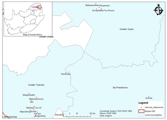
Figure 1.
Location of informal settlements in Mopani District Local Municipality. Source: Authors (2022).
The district comprises five local municipalities: Greater Giyani, Greater Letaba, Ba-Phalaborwa, Maruleng and Greater Tzaneen, and each has elements of informal settlements established in fragile areas. Out of the entire district population, 81% reside in rural areas, 14% in urban areas and 5% stay on farms. The population densities vary from one municipality to another, and the current average is 57.4 people per square kilometre [32]. It shows that people are still sparsely populated with relatively adequate land around them. The population of Mopani District is gradually increasing by 3%, and this still calls for an urgent need for balanced use of land in urban areas since this increase is projected to increase [33].
3. Materials and Methods
This descriptive research was designed as a case study of 15 informal settlements of the 3 local municipalities (see Figure 1) in Mopani District, a disaster prone area [1,20] in Limpopo Province, South Africa. The location of Mopani District attracts unemployed youth and migrants from Mozambique and Zimbabwe who migrate to South Africa in search for “greener pastures” and, as such, create informal settlements, which are usually exposed to disaster risks. The population data of the communities in the 15 informal settlements was not available; therefore, 8187 households constituted the population of the study in the 15 informal settlements in the 3 local municipalities in Mopani District [26]. These informal settlements were purposively selected based on the size, complexity and history of occurrence of disasters and on the assumption that these local municipalities are the beneficiaries of the National Upgrading Programmes whose aim is to reduce disaster risks and create sustainable development in such communities [34]. Using the [35] formula, at a confidence level of 96%, the actual sample size of the households was 608 households. The study computed the proportional sample for all the 15 selected informal settlements to show equal representation in the survey. To compute the proportional samples, the populations of the selected informal settlements and their corresponding proportional sample sizes were rounded off to obtain resultant figures in whole numbers. These are Kurhula (117), Ma-Two Rooms (26), Dumpsite (4), Matshamahikani (15), Hluphekani (10), Near Agriculture (3), Burgersdorp (92), Gavaza (46), Mbambamencisi (78), Mohlaba Cros V2 (33), Mokgolobatho (95), Nkambako (35), Kuwait (21), Mapolakeng (20) and Dan (13).
The article assesses the informal settlement community’s awareness level of the spatial planning tools for disaster risk reduction in the Greater Giyani, Greater Tzaneen and Ba-Phalaborwa local municipalities. A literature review was conducted to enable the assemblage and codification of the spatial planning tools for disaster risk reduction as follows; Integrated Development Planning “IDP”, Spatial Development Framework “SDF”, Land Use Scheme “LUS”, Zoning “ZON”, Subdivision “SUBDiV”, Building codes and standards “BLDCS”, Land use application determination “LUAD” and Land use bylaws “LUByL”, and an awareness factor under each spatial planning tool was identified. These supported the development of the ‘spatial planning tools’ awareness questionnaire that was distributed to 608 respondents who own temporal structures in informal settlements yet to be upgraded and those who own permanent structures in upgraded informal settlements. The questionnaire had both open- and closed-ended questions. By answering the question “To what extent are you aware of the following spatial planning tools?” and explaining the reason for the choices with a 5-point Likert Scale of 1–5, the study assessed the participants’ knowledge, understanding and awareness level of the spatial planning tools for disaster risk reduction. The Likert scale was as follows: 5 = extremely aware; 4 = moderately aware; 3 = somewhat aware; 2 = slightly aware and 1 = not at all aware. In the analysis, the Relative Importance Index was used in the study to assess the extent of the informal settlement community’s awareness levels of spatial planning tools for disaster risk reduction. In addition, respondents were asked to indicate their age, gender, education and income levels to assess their social- demographical characteristics in relation to their awareness level of spatial planning tools for disaster risk reduction. A t-test and one-way analysis of variance (ANOVA) were also conducted to determine the differences in awareness levels of spatial planning tools between the respondents’ different characteristic- based groups (gender, age, income and education levels). The awareness level variable used in the test was obtained by calculating a mean of the respondents’ awareness levels of the individual spatial planning tools, and this formed a composite variable of the study.
Relative Importance Index (RII) Analysis
The Relative Importance Index is an important tool used to assess the importance, knowledge, understanding and awareness levels of a unit of study in relation to a given phenomenon [36,37,38,39,40,41,42,43].
In this study, the data generated from the spatial planning tools questionnaire survey were analysed using the Relative Importance Index (RII) in order to determine the informal settlement community’s importance, knowledge, understanding and awareness levels of each spatial planning tool/factor, which were calculated using the formula below.
where,
- ○
- “W” is the weight given to each awareness factor by the respondent within the range {1, 2, 3, 4 and 5}, multiplied by the number of respondents {n1, n2, n3, n4, n5} for each factor;
- ○
- “n1” = number of respondents who were not at all aware;
- ○
- “n2” = number of respondents who were slightly;
- ○
- “n3” = number of respondents who were somewhat aware;
- ○
- “n4” = number of respondents who were moderately aware;
- ○
- “n5” = number of respondents who were extremely aware;
- ○
- “A”: highest weight (in this study: 5);
- ○
- “N”: overall number of respondents (returned questionnaires: 605)
The values of the RII were then transformed into five important/awareness levels as suggested by [44,45], and followed by recent studies [40,41,42,43,46]. These levels are high (H) (0.8 ≤ RI ≤ 1), high-medium (H–M) (0.6 ≤ RI ≤ 0.8), medium (M) (0.4 ≤ RI ≤ 0.6), medium-low (M–L) (0.2 ≤ RI ≤ 0.4) and low (L) (0 ≤ RI ≤ 0.2). To determine the awareness level of each spatial planning tool for disaster risk reduction, the RII under each spatial planning tool were assigned an importance/ awareness level as explained above.
4. Results
4.1. Social-Demographic Characteristics of Respondents
Table 1 shows the characteristics of the respondents. The majority of the respondents (74%) were male and aged between 18–40 years (72%). Most of the respondents also had low qualifications (Secondary and below, 85%) and earned a low income of R5000 and below (73%).

Table 1.
Characteristics of the respondents.
4.2. Awareness Level of Spatial Planning Tools
In order to evaluate the respondents’ knowledge, understanding and awareness level of the spatial planning tools for disaster risk reduction in the Greater Giyani, Greater Tzaneen and Ba-Phalaborwa local municipalities, the respondents were asked to indicate and explain the extent to which they were aware of the spatial planning tools. As shown in Figure 2, respondents showed a moderate understanding and awareness level of the spatial planning tools for disaster risk reduction.
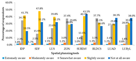
Figure 2.
Responses on awareness of spatial planning tools. Source: Field survey result (2021).
Figure 2 shows the percentage responses of the informal settlements community in terms of the awareness of the Integrated Development Plan (IDP), Spatial Development Framework (SDF), Land Use Scheme (LUS), Zoning (ZON), Sub-divisions (SUBDiV), Building codes and standards (BLDCS), Land use application determination (LUAD) and Land use bylaws (LUByL). The results show that there is no extensive awareness of spatial planning tools for disaster risk reduction among the informal settlement community in the Greater Giyani, Greater Tzaneen and Ba-Phalaborwa local municipalities. The assessment reveals that the percentage number of the respondents who were “extremely aware” of the spatial planning tools lie between 0.8% and 1.8%, “moderately aware” lie between 1.8% and 3.3%, and “somewhat aware” lie between 13.1% and 37.7%. It can be noted that the majority of the respondents were “slightly aware” of the SDF (47.8%), IDP (41.7%) and LUS (39.8%), “somewhat aware” of Building codes and standards (37.7%) and Zoning (37.4%), and “not aware at all” of Subdivision (43.5%), Land use application determination (38.3%) and Land use bylaws (38%). This suggests that only a minority of the informal settlers are “extremely and moderately” aware of the spatial planning tools, and the majority are “slightly, somewhat and others not at all” aware of the spatial planning tools for disaster risk reduction. Further analysis (Table 2) shows the combined average scores gathered from the participants in order to produce the Relative Importance Index (RII) values of the eight identified spatial planning tools and associated factors. In this regard, the awareness level of spatial planning tools was determined by transforming the RII values to form five important levels: high (H) (0.8 ≤ RII ≤ 1), high-medium (H–M) (0.6 ≤ RI ≤ 0.8), medium (M) (0.4 ≤ RI ≤ 0.6), medium-low (M–L) (0.2 ≤ RI ≤ 0.4) and low (L) (0 w (M.4 mportance Index (RII) values of the eight identified spatial Table 1.
Table 2.
Awareness level of spatial planning tools.
As shown in Table 2, the ranking of the respondents’ awareness and knowledge of the spatial planning tools is in the following order: firstly, Integrated Development Plans, followed by Building codes and standards, Zoning, Land Use Scheme, Land use application determination, Land use bylaws, Spatial Development Frameworks and Sub-divisions. The ranking analysis reveals that the awareness level of the spatial planning tools for disaster risk reduction in Mopani District falls under “Medium” or “Medium-low” levels of awareness. From the results, respondents showed a “Medium” awareness level of “Integrated Development Plan (IDP)”, “Building codes and standards (BLDCS)”, “Zoning (ZON)” and the “Land Use Scheme (LUS)” and a “Medium- low” awareness level of the “Land use application (LUAD)”, “Land use by-laws (LUByL)”, “Spatial Development Framework” and “Subdivision SUBDiV”.
4.3. Differences in Awareness Levels of Spatial Planning Tools Based on the Social-Demographics of Respondents
The group differences between the scale scores and the associations between respondents’ characteristics and the scale scores examined using a t-test and ANOVA are presented below (Table 3).
Table 3.
T-test and one-way ANOVA.
The t-test showed that there was a significant gender-based difference in the awareness of spatial planning tools for disaster risk reduction (t = 2.27, p = 0.012 [<0.05]) (Table 3). The females showed a low awareness level of the spatial planning tools than the male counterparts (1.92 vs. 2.08, p-value = 0.012). In addition, the ANOVA analysis showed that there were no significant age-based differences in the awareness of spatial planning tools for disaster risk reduction but revealed that there were significant income level-based (f = 9.87, p = < 0.001 [<0.05]), and education level-based (f = 6.84, p = < 0.001 [<0.05]) differences in the awareness of spatial planning tools for disaster risk reduction. Low-income earners and respondents with low qualifications show a low awareness level of spatial planning tools for disaster risk reduction.
5. Discussion
The disposition to reduce disaster risks globally has drawn the attention of different scholars and development agencies, who primarily focus on how the governments, spatial planning practitioners and other stakeholders can contribute to disaster risk reduction in various spaces including informal settlements [47,48]. Several initiatives have been introduced to reduce disaster risks from an international to a local level. Despite the initiatives, disaster risks are incessantly increasing in various spaces including informal settlements. This anomaly is possibly due to the low awareness level of spatial planning tools, which many scholars have found to be important in disaster risk reduction [49]. This study, through a questionnaire survey, assessed the awareness level of spatial planning tools for disaster risk reduction in informal settlements in Mopani District.
The quantitative analysis performed in Section 4 shows the analysis of 605 questionnaires conducted with respondents on their awareness level of spatial planning tools for disaster risk reduction in Mopani District, South Africa.
The results show that the awareness level of spatial planning tools for disaster risk reduction among the community in the informal settlements is moderate to low (see Figure 2 and Table 2). This means that, though inadequate, the municipalities have attempted to create awareness of spatial planning tools to limit disaster risks in the informal settlements through ward councillors and integrated development planning forums.
These results agree with those of Mamokhere and Meyer [50]’s study, which revealed that 48% of respondents in their sample in the Tzaneen local municipality in Mopani District were familiar with the IDP, one of the spatial planning tools. Mathebula, Nkuna and Sebola [51] associate this state of awareness to Mopani District’s inability to include municipal residents in the participatory processes of management planning, formulation and implementation of the IDP, thereby impacting the awareness level of spatial planning tools for disaster risk reduction.
The results also show that gender, income and education level were associated with the awareness level of the spatial planning tools for disaster risk reduction. The male respondents being more aware of spatial planning tools is supported by past studies [52,53]. In addition, the study found out that informal settlers with low incomes and low educational levels [54,55] showed low levels of awareness of spatial planning tools and are therefore more exposed to the possibility of loss of life and destruction of property [54].
In this study, respondents explained that due to poverty, unemployment and low education, it is costly for them to comply with the spatial planning tools—for example, building codes and standards (building materials), land use application (land survey) and building permits—thereby leaving the informal settlers with no option other than settling in areas prone to water, fire and health disaster risks such as dumpsites, wetlands, flood plains, forests and hilltops in Mopani District. In addition, the general attitude of informal settlers towards spatial planning tools is that these tools are for professionals and “the well to do”, leading to the low awareness level of the spatial planning tools for disaster risk reduction.
6. Conclusions
This study aimed to assess the residents’ awareness level of spatial planning tools for disaster risk reduction in informal settlements. Based on the findings of the study, the following conclusions can be drawn. Firstly, there is a moderate to low level of awareness of spatial planning tools for disaster risk reduction amongst the community living in informal settlements of Mopani District. Secondly, there are significant differences in awareness levels of spatial planning tools between the sub-groups based on gender, education and income levels. In line with this assessment, the females, low-income earners and less educated have a lower awareness level of spatial planning tools for disaster risk reduction. It is suggested that focusing on raising awareness of spatial planning tools for disaster risk reduction among the females, low-income earners and less educated to promote safe, healthy and liveable spaces in informal settlements should be prioritized, given the increasing number of disaster risks and sporadic increase of informal settlements in Mopani District and South Africa in general. Hence, the Greater Giyani, Greater Tzaneen and Ba-Phalaborwa local municipalities can intensify awareness creation campaigns through various media such as radios, televisions, newspapers, brochures and online forums on social media and the internet in both official and local languages.
Author Contributions
Conceptualization, J.A.; methodology, J.A.; validation, P.B., E.I. and J.C.; formal analysis, J.A.; investigation, P.B.; resources, J.A.; data curation, J.C.; writing—original draft preparation, J.A.; writing—review and editing, E.I.; visualization, P.B.; supervision, J.C.; project administration, J.C.; funding acquisition, J.A. All authors have read and agreed to the published version of the manuscript.
Funding
The University of Venda under the Capacity Development Grant, grant number 6959, funded this research.
Institutional Review Board Statement
The study was conducted in accordance with the University of Venda ethical guidelines and approved by the Ethics Committee (Project NO SES/20/ERM/10/1111 and date of approval was 11 November 2020).
Informed Consent Statement
Informed consent was obtained from all subjects involved in the study.
Data Availability Statement
The data presented in this study is available upon corroborated request from the corresponding author.
Acknowledgments
The authors would like to acknowledge the support of those who directly or indirectly contributed to the success of this study.
Conflicts of Interest
The authors declare no conflict of interest.
References
- Akola, J.; Chakwizira, J.; Ingwani, E.; Bikam, P. An AHP-TOWS Analysis of Options for Promoting Disaster Risk Reduction Infrastructure in Informal Settlements of Greater Giyani Local Municipality, South Africa. Sustainability 2023, 15, 267. [Google Scholar] [CrossRef]
- Omid, M. Strategic planning and urban development by using the SWOT analysis. The case of Urmia city. Rom. Rev. Reg. Stud. 2014, 10, 47–54. [Google Scholar]
- Somiah, M.; Ayarkwa, J.; Agyekum, K. Assessing House-Owners’ Level of Awareness on the National Building Regulations, L.I. 1630, in the Sekondi-Takoradi Metropolis. African J. Appl. Res. 2015, 1, 170–178. [Google Scholar]
- Belle, J.A.; Collins, N.; Jordaan, A. Managing wetlands for disaster risk reduction: A case study of the eastern Free State, South Africa. Jamba J. Disaster Risk Stud. 2018, 10, 1–10. [Google Scholar] [CrossRef] [PubMed]
- Mtani, I.W.; Mbuya, E.C. Urban fire risk control: House design, upgrading and replanning. Jàmbá J. Disaster Risk Stud. 2018, 10, 1–8. [Google Scholar] [CrossRef]
- Strauss, M. A historical exposition of spatial injustice and segregated urban settlement in South Africa. Fundamina 2019, 25, 135–168. [Google Scholar] [CrossRef]
- Eliades, F.; Doula, M.K.; Papamichael, I.; Vardopoulos, I.; Voukkali, I.; Zorpas, A.A. Carving out a Niche in the Sustainability Confluence for Environmental Education Centers in Cyprus and Greece. Sustainability 2022, 14, 8368. [Google Scholar] [CrossRef]
- Akola, J.; Chakwizira, J.; Ingwani, E.; Bikam, P. The Contribution of Spatial Planning Tools towards Disaster Risk Reduction in Informal settlement in South Africa. In Sustainanble and Smart Spatial Planing in Africa, 1st ed.; CRC Press: Abingdon, UK, 2022; Volume 16. [Google Scholar]
- UNDP. 2018 Review of SDGs Implementation: SDG 11—Make Cities and Human Settlements Inclusive, Safe, Resilient and Sustainable; UNDP: New York, NY, USA, 2018. [Google Scholar]
- Kamaruddin, S.M.; Ahmad, P.; Alwee, N. Community Awareness on Environmental Management through Local Agenda 21 (LA21). Procedia—Soc. Behav. Sci. 2016, 222, 729–737. [Google Scholar] [CrossRef]
- Turan Çimşir, B.T.; Uzunboylu, H. Awareness Training for Sustainable Development: Development, Implementation and Evaluation of a Mobile Application. Sustainability 2019, 11, 611. [Google Scholar] [CrossRef]
- World Bank Group. Building Regulation for Resilience: Managing Risks for Safer Cities; The World Bank: Washington, DC, USA, 2015. [Google Scholar]
- South African Cities Network (SACN). SPLUMA as a Tool for Spatial Transformation; South African Cities Network: Johannesburg, South Africa, 2017. [Google Scholar]
- Van Dewald, N. Introduction To Disaster Risk Reduction; USAID: Washington, DC, USA, 2011; Volume 59.
- ARUP. A Framework for Fire Safety in Informal Settlements; Arup International Development: London, UK, 2018; pp. 1–32. [Google Scholar]
- Department of Human Settlement (DHS). Official Guide to South Africa 2020/21; DHS: Pretoria, South Africa, 2020.
- Bündnis Entwicklung Hilft. WorldRiskReport 2022: Focus Digitalization; Bündnis Entwicklung Hilft: Berlin, Germany, 2022. [Google Scholar]
- McMillan, J.M.; Birkmann, J.; Tangwanichagapong, S.; Jamshed, A. Spatial Planning and Systems Thinking Tools for Climate Risk Reduction: A Case Study of the Andaman Coast, Thailand. Sustainability 2022, 14, 8022. [Google Scholar] [CrossRef]
- Debrah, J.K.; Vidal, D.G.; Dinis, M.A.P. Raising Awareness on Solid Waste Management through Formal Education for Sustainability: A Developing Countries Evidence Review. Recycling 2021, 6, 6. [Google Scholar] [CrossRef]
- Nembilwi, N.; Chikoore, H.; Kori, E.; Munyai, R.B.; Manyanya, T.C. The occurrence of drought in Mopani district municipality, South Africa: Impacts, vulnerability and adaptation. Climate 2021, 9, 61. [Google Scholar] [CrossRef]
- Todes, A.; Karam, A.; Klug, N.; Malaza, N. Beyond master planning? New approaches to spatial planning in Ekurhuleni, South Africa. Habitat Int. 2010, 34, 414–420. [Google Scholar] [CrossRef]
- Department of Rural Development and Land Reform. Spatial Planning and Land Use Management Act 16 of 2013; Rural Development and Land Reform: Pretoria, South Africa, 2013; pp. 1–72.
- Cilliers, J.; Victor, H. Considering spatial planning for the South African poor: An argument for ‘planning with’. Town Reg. Plan. 2018, 72, 29–42. [Google Scholar]
- Van Huyssteen, E.; le Roux, A.; van Niekerk, W. Analysing risk and vulnerability of South African settlements: Attempts, explorations and reflections. Jamba J. Disaster Risk Stud. 2013, 5, 1–8. [Google Scholar] [CrossRef]
- Department of Rural Development and Land Reform. Land Use Scheme Guidelines; Rural Development and Land Reform: Pretoria, South Africa, 2017; pp. 1–82.
- Mopani District Municipality. Draft Reviewed Integrated Development Plan 2016–2021; Mopani District Municipality: Mopani, South Africa, 2019. [Google Scholar]
- Asian Development Bank. Reducing Disaster Risk by Managing Urban Land Use: Guidance Notes for Planners; Asian Development Bank: Metro Manila, Philippines, 2016. [Google Scholar]
- Department of Rural Development and Land Reform. Guidelines for the Development of Spatial Development Frameworks; No. 8. Rural Development and Land Reform; Republic of South Africa: Pretoria, South Africa, 2011; pp. 9–12.
- Minnie, J. Informal Settlements Fire and Flooding Risk Reduction Strategy. In Dmisa Western Cape Provincial Workshop in July; DMISA: Germiston, South Africa, 2005; Volume 2012, pp. 1–42. [Google Scholar]
- Laws Africa. Open Bylaws South Africa. 2021. Available online: https://openbylaws.org.za/about.html#:~:text=By-lawsarelawsmanagedbymunicipalities.TheConstitutionandforceasothernationalandprovinciallegislation (accessed on 27 April 2021).
- National Disaster Management Centre. Introduction: A Policy Framework for Disaster Risk Management in South Africa; National Disaster Management Centre: Pretoria, South Africa, 2005.
- Mopani District. Community Survey; Population of Mopani District; Wazi Maps: Pretoria, South Africa, 2016. [Google Scholar]
- Statistics South Africa. Statistical Release Census 2011; Statistics South Africa: Pretoria, South Africa, 2011; p. P0301.4.
- Mopani District Municipality. Mopani District Municipality: Draft Annual Report; Mopani District Municipality: Tzaneen, South Africa, 2019. [Google Scholar]
- Kothari, C.R. Research Methodology: Methods and Techniques, 2nd ed.; New Age International Publishers: New Delhi, India, 2004. [Google Scholar]
- Somiah, M.K.; Osei-Poku, G.; Aidoo, I. Relative Importance Analysis of Factors Influencing Unauthorized Siting of Residential Buildings in the Sekondi-Takoradi Metropolis of Ghana. J. Build. Constr. Plan. Res. 2015, 3, 117–126. [Google Scholar] [CrossRef]
- Rooshdi, R.R.R.M.; Majid, M.Z.A.; Sahamir, S.R.; Ismail, N.A.A. Relative importance index of sustainable design and construction activities criteria for green highway. Chem. Eng. Trans. 2018, 63, 151–156. [Google Scholar]
- Al Khatib, B.; Poh, Y.S.; El-Shafie, A. Delay factors management and ranking for reconstruction and rehabilitation projects based on the Relative Importance Index (RII). Sustainability 2020, 12, 6171. [Google Scholar] [CrossRef]
- Kassem, M.A.; Khoiry, M.A.; Hamzah, N. Using Relative Importance Index Method for Developing Risk Map in Oil and Gas Construction Projects. J. Kejuruter. 2020, 32, 441–453. [Google Scholar] [CrossRef]
- Minhas, M.R.; Potdar, V. Development of an Effective System for Selecting Construction Materials for Sustainable Residential Housing in Western Australia. Appl. Math. 2020, 11, 825–844. [Google Scholar] [CrossRef]
- Hamdoun, A. Academic leadership commences by self-leadership. In Proceedings of the SHS Web of Conferences EECME 2021, Ljubljana, Slovenia, 28 May 2021; Volume 111, p. 0100. [Google Scholar]
- Tholibon, D.A.; Nujid, M.; Mokhtar, H.; Rahim, J.A.; Aziz, N.F.A.; Tarmizi, A.A.A. Relative Importance Index (RII) In Ranking the Factors of Employer Satisfaction Towards Industrial Training Students. Int. J. Asian Educ. 2021, 2, 493–503. [Google Scholar] [CrossRef]
- Akadir, O.P. An Analysis of Building Information Modeling (BIM) Usage in Nigerian Construction Industry. Int. Res. J. Eng. Technol. 2022, 9, 2410–2419. [Google Scholar]
- Chen, Y.; Okudan, G.E.; Riley, D.R. Sustainable performance criteria for construction method selection in concrete buildings. Autom. Constr. 2010, 19, 235–244. [Google Scholar] [CrossRef]
- Akadir, O.P. Development of a Multi-Criteria Approach for the Selection of Sustainable Materials for Building Projects. Ph.D. Thesis, University of Wolverhampton, Wolverhampton, UK, 2011. [Google Scholar]
- Chuweni, N.N.; Mohamed Saraf, M.H.; Fauzi, N.S.; Kasim, A.C. Factors Determining the Purchase Decission of Green Residential Properties in Malaysia. J. Malaysian Inst. Planners 2022, 20, 272–282. [Google Scholar]
- Satterthwaite, D.; Sverdlik, A. Assessing Health Risks in Informal Settlements in Sub-Saharan African Cities; Urban Africa Risk Knowledge: Holborn, UK, 2018. [Google Scholar]
- Satterthwaite, D.; Archer, D.; Colenbrander, S.; Dodman, D.; Hardoy, J. Responding to climate change in cities and in their informal settlements and economies. In Proceedings of the International Scientific Conference on Cities and Climate Change, Edmonton, AB, Canada, 5–7 March 2018; Volume 26, pp. 1–61. [Google Scholar]
- Dodman, D.; Archer, D.; Mayr, M.; Engindeniz, E. Pro-Poor Climate Action in Informal Settlements; UN-Habitat: Nairobi, Kenya, 2018; Volume 46, pp. 1–60. [Google Scholar]
- Mamokhere, J.; Meyer, D.F. A Review of Mechanisms Used to Improve Community Participation in the Integrated Development Planning Process in South Africa: An Empirical Review. Soc. Sci. 2022, 11, 448. [Google Scholar] [CrossRef]
- Mathebula, N.E.; Nkuna, N.W.; Sebola, M.P. Integrated Development Plan for Improved Service Delivery: A Comparative Study of Municipalities Within the Mopani District Municipality, Limpopo Province. Int. J. Bus. Manag. Stud. 2016, 8, 1309–8047. [Google Scholar]
- McDowell, C.P.; Andrade, L.; O’neill, E.; O’malley, K.; O’dwyer, J.; Hynds, P.D. Gender-related differences in flood risk perception and behaviours among private groundwater users in the Republic of Ireland. Int. J. Environ. Res. Public Health 2020, 17, 2072. [Google Scholar] [CrossRef]
- Guiné, R.P.F.; Florença, S.G.; Anjos, O.; Boustani, N.M.; Chuck-Hernández, C.; Sarić, M.M.; Ferreira, M.; Costa, C.A.; Bartkiene, E.; Cardoso, A.P.; et al. Are Consumers Aware of Sustainability Aspects Related to Edible Insects? Results from a Study Involving 14 Countries. Sustainability 2022, 14, 14125. [Google Scholar] [CrossRef]
- Cerulli, D.; Scott, M.; Aunap, R.; Kull, A.; Pärn, J.; Holbrook, J.; Mander, Ü. The role of education in increasing awareness and reducing impact of natural hazards. Sustainability 2020, 12, 7623. [Google Scholar] [CrossRef]
- Keleş, A.E.; Önen, E.; Górecki, J. Determination of Green Building Awareness: A Study in Turkey. Sustainability 2022, 14, 11943. [Google Scholar] [CrossRef]


Disclaimer/Publisher’s Note: The statements, opinions and data contained in all publications are solely those of the individual author(s) and contributor(s) and not of MDPI and/or the editor(s). MDPI and/or the editor(s) disclaim responsibility for any injury to people or property resulting from any ideas, methods, instructions or products referred to in the content. |
© 2023 by the authors. Licensee MDPI, Basel, Switzerland. This article is an open access article distributed under the terms and conditions of the Creative Commons Attribution (CC BY) license (https://creativecommons.org/licenses/by/4.0/).