Article

Disaster Risk Management and Spatial Planning: Evidence from the Fire-Stricken Area of Mati, Greece

by
Miranda Dandoulaki
1,
Miltiades Lazoglou
2,*,
Nikos Pangas
1 and
Konstantinos Serraos
1
1
Urban Planning Research Laboratory, School of Architecture, National Technical University of Athens, 10682 Athens, Greece
2
Department of Surveying and Geoinformatics Engineering, School of Engineering, University of West Attica, 12244 Aigaleo, Greece
*
Author to whom correspondence should be addressed.
Sustainability 2023, 15(12), 9776; https://doi.org/10.3390/su15129776
Submission received: 15 March 2023 / Revised: 7 June 2023 / Accepted: 13 June 2023 / Published: 19 June 2023

Abstract

:
The debate over spatial planning highlights the need for more interdisciplinary, strategic, and collaborative methods to achieve broad policy goals such as resilience and sustainability. Risk-based planning is gaining importance due to the rising vulnerability of urban infrastructure. Incorporating disaster risk management into spatial planning requires a geographically based strategy for reducing catastrophe risk. This article outlines the role of spatial planning in the reconstruction of the Mati settlement in Attica, Greece, that was devastated by a forest fire in 2018. It presents a set of proposals that relate to the urban reorganization of the area and considers disaster risk reduction and disaster management, as well as sustainability issues relating to mobility, the management of the natural environment, and the recovery of the coastline as a public resource. The basis for this article is the contribution of the Urban Planning Research Laboratory of the National Technical University of Athens/School of Architecture to the preparation of the Special Urban Plan for the fire-stricken area of Mati, Attica, on behalf of the Technical Chamber of Greece.

1. Introduction

Spatial planning is currently regarded as a valuable panoptic tool towards sustainable development, disaster risk reduction, and climate change adaptation [1]. Its role is highlighted in major global policy agendas such as the Sendai Framework for Disaster Risk Reduction 2015–2030 [2] and the Agenda and Sustainable Development Goals (SDG) 2015–2030 [3]. Furthermore, spatial planning is increasingly recognized as a critical cross-cutting instrument that can support adaptation to hazards aggravated by changes in climate patterns and extreme events [4] and is even significant for climate change mitigation [5,6,7]. The discussion on spatial planning also emphasizes the need for more interdisciplinary, strategic, and participatory approaches to achieve overarching policy objectives such as resilience and sustainability [8].
Spatial planning presents an approach to development in its territorial social, economic, and environmental dimensions. The links between disaster and development have been long recognized [9] and have been investigated further to point towards the structural root causes of vulnerability [10]. Vulnerability has been raised as a central concept [11,12] and operationalized in the disasters field. Its significance has been recently reintroduced [13,14], even though the umbrella notions of resilience to hazards and urban resilience dominate both academic discourse and policies. Consequently, the need for risk-based planning is rising due to the increasing exposure and vulnerability of urban settings and those who rely on them [15,16,17].
Spatial planning can positively contribute to reducing disaster risk and enhancing the resilience of cities by providing secure land and its safe use for socially and economically disadvantaged city residents through participatory processes; reflecting infrastructure provision in spatial plans; and ensuring that poverty reduction and addressing socio-environmental and spatial inequalities are development criteria for urban development and improvement [1]. Moreover, it “creates the preconditions required to achieve a type of land use that is environmentally sustainable, socially just and desirable, and economically sound. It thereby activates social processes of decision- making and consensus building concerning the utilization and protection of private, communal, or public areas” [18].
The most important aspects are the implementation of appropriate planning policies, laws, spatial plans, urban standards, and regulations; the inclusion of diverse stakeholders and voices; strengthening the understanding of the spatial, regional, and relational aspects of disasters, disaster risk, and disaster impacts; further mitigating and adapting to climate change and protecting ecosystems; and facilitating links between different scales of responsibility [19].
In addition to addressing urban growth, poverty, and urbanization processes that lead to inequalities and increased vulnerability, risk reduction is an indispensable aspect of spatial planning that should be addressed [20]. A strategy for reducing disaster risk that assesses the spatial dimension is required to incorporate disaster risk management into spatial planning [21]. This can be achieved by taking more targeted action to address urban areas’ underlying disaster risk aspects and integrating disaster risk reduction into spatial planning. These pursuits are required to achieve the desired outcome.
Focusing on the Greek context, these questions are addressed in the fire-stricken area of Mati, on the eastern coast of Attica, which was severely burnt by wildfires on 23 July 2018. A new spatial plan that includes defining segments of the fire-ravaged areas of Mati and the neighboring Rafina area has been approved by the Greek Environment and Energy Ministry.
In this article, a set of proposals for the reconstruction of the area of Mati are presented. These proposals directly relate to the urban reorganization of the study area, disaster risk and disaster management issues, the general organization of the road network and transportation, the layout structure and guidelines for sustainable mobility, the management of the natural environment, and procedures for the recovery of the coastline as a public resource.
The contribution of the Urban Planning Research Laboratory (UPRL) of the National Technical University of Athens/School of Architecture (NTUA) to the preparation of the Special Urban Plan (SUP) for the fire-stricken area of Mati, Attica, on behalf of the Technical Chamber of Greece is the basis for this article [19]. The objective of the research program was to promote an innovative approach to urban spatial planning, focusing on the principles of sustainable spatial development, environmental protection, and considering disaster risk reduction and disaster management.
This research program is of high significance for spatial planning in Greece because it explores a new planning tool called a Special Urban Plan (SUP) that can be used for disaster risk reduction, among others, and was tested for disaster reconstruction in the Mati area for the first time. The acquired knowledge provides the basis for the development of training material on urban management and the reconstruction of settlements facing high disaster risks against natural hazards such as earthquakes, fires, and floods.

2. Spatial Planning and Disaster Risk Management

Relationship between Spatial Planning and Disaster Risk Management

Spatial planning is a key instrument for establishing long-term, sustainable frameworks for social, territorial, and economic development both within and between countries. Its primary role is to enhance the integration between sectors such as housing, transport, energy, and industry, and to improve national and local systems of urban and rural development, while also taking into account environmental considerations [22]. It also has the potential to reduce disaster risk identified as the potential loss of life, injury, or destroyed or damaged assets which could occur to a system, society, or a community in a specific period of time [2]. After all, spatial planning could modify all the main components of disaster risk, which are hazard, exposure, vulnerability, and capacity. For example, it could suitably direct patterns of the population and socioeconomic development in an area. Planning the structure of an area can also be a factor in reducing disaster risk to different hazards.
Disaster prevention aims to eliminate all potential adverse effects from hazardous events [23]. Since hazards cannot be eliminated, the objective is to reduce vulnerability, exposure, increase capacity, and thus reduce disaster risk. During or after a hazardous event or disaster, measures can be taken to reduce disaster risk and prevent secondary hazards or their effects. In its regulatory role [19], spatial planning allocates land uses and defines spatial development, taking into consideration the likelihood of a hazardous phenomenon or process of a certain severity occurring in a location (e.g., prohibiting building in zones with a high risk of landslides). Buffer zones are often used to mitigate hazardous effects (protective forests, retention ponds, etc.). It also defines the intensity of development (building densities, heights etc.). Risk exposure is reduced by regulating the location, type, and intensity of uses in different areas (e.g., planning regulations requiring elevation of buildings in flood zones).
Furthermore, spatial planning relates to disaster management, identified as the organization, planning, and application of measures preparing for, responding to, and recovering from disasters (UNDRR Terminology) [2]. It focuses on creating and implementing preparedness and other plans to decrease the impact of disasters and “build back better”. For example, emergency evacuation, access of first responders, and distribution of aid present distinct spatial dimensions that should concern spatial planning.
Moreover, a significant strength of spatial planning in reducing disaster risk and better disaster management has to do with governance. Disaster risk reduction involves numerous stakeholders and policies for developing and protecting vulnerable assets [24]. It concerns numerous sectoral policies at all levels of government, from national to local, and in the public, commercial, and civil sectors. At a national level, the risk reduction in the transport infrastructure is mainly the concern of the Ministry of Infrastructure and Transport; natural resources are the concern of the Ministry of Environment and Natural Resources; cultural infrastructure and assets are the concern of the Ministry of Culture; agricultural infrastructure and assets are the concern of the Ministry of Agriculture; and educational infrastructure and the school community are the concern of the Ministry of Education. Similarly, according to their responsibilities, each municipality and region is accountable for prevention measures and actions related to various categories of exposed assets at the local level. Therefore, governance is a prime concern in disaster risk reduction and management policies as demonstrated by the fact that strengthening disaster risk governance is set among the four priorities of the Sendai Global Framework for Disaster Risk Reduction for 2015–2030. In this respect, spatial planning is experienced in participatory approaches and tools and is equipped to employ them to mainstream disaster risk reduction and disaster management.
Cities and towns, like other spatial entities, should be able to adapt to, transform, and recover from the effects of a hazard, a threat, or a shock in cases of crises and disasters, be they economic (e.g., the recent financial crisis), social (e.g., the massive influx of refugees), environmental pressures (climate change), or the manifestation of hazardous natural phenomena (e.g., earthquakes, floods, fires, and heatwaves). In this effort, the role of spatial planning is expected to be critical, particularly regarding the urban environment [25]. With respect to natural hazards, spatial planning is expected to [19] (a) act proactively, i.e., reduce the probability of disaster against natural hazards in an area, (b) mitigate the impacts of the occurrence of hazards and help to address them effectively, and (c) contribute to the recovery and re-balancing process. In other words, it is expected to increase the resilience of spatial entities. Accepting the UNDRR terminology [2], in this paper, resilience is considered “the ability of a system, community or society exposed to hazards to resist, absorb, accommodate, adapt to, transform and recover from the effects of a hazard in a timely and efficient manner, including through the preservation and restoration of its essential basic structures and functions through risk management”.
Spatial planning is crucial in mitigating risks and coordinating all functions and services related to interventions within defined spatial entities [4]. For instance, preserving large open or green spaces for the temporary refuge of the population in the event of an earthquake and preserving a porous surface to absorb the water of a sudden deluge. Thus, nature and natural processes are consciously incorporated into spatial planning, and the well-designed land-use mosaic can perform multiple functions and provide numerous services to society.
Spatial planning is an important factor in managing the effects of urbanization and its impacts on climate [26]. Urbanization can cause various climate effects, such as increased air pollution, greater water consumption, and more waste generation. To mitigate these effects, spatial planning must be implemented to ensure the efficient use of resources and the effective management of land use [27]. This could include implementing green infrastructure, such as parks and gardens, to provide cooling and reduce air pollution. Additionally, land-use zoning could reduce the amount of land dedicated to high-consumption activities and encourage more sustainable practices. Spatial planning could introduce a methodology for disaster prevention and risk reduction. Particular emphasis could be placed on spatially based risk reduction tools and the role of spatial and urban planning in enhancing disaster preparedness. By taking these steps, spatial planning can help reduce the negative climate impacts of urbanization.
Urbanization can result in several negative environmental impacts that need to be better managed. This can increase the risk for inhabitants as there is an increase in informal settlements and slums, which often lack basic amenities and infrastructure. Poorly managed water sources can further intensify the problem. Furthermore, the degradation or elimination of environmental buffers, such as mangroves and wetlands, can also exacerbate the problems associated with urbanization. To mitigate these risks, it is essential to ensure that urbanization is managed responsibly and sustainably.
Risk-based spatial plans are a powerful tool for mitigating the potential impacts of climate change. This type of spatial planning involves analyzing climate-related risks to identify areas vulnerable to extreme weather events or other climate-induced disasters. By proactively identifying these risk areas and planning for their potential impacts, communities can better prepare for the future. Risk-based spatial plans also provide an opportunity to assess the effectiveness of existing land-use regulations and identify areas where additional protections may be needed [28]. As the impacts of climate change increase, risk-based spatial plans may be utilized to develop strategies that can help communities adapt to a changing climate.
Zoning plans based on hazard maps can be a helpful tool to reduce exposure to dangerous events. Such plans can limit or eliminate the development of areas prone to natural hazards such as floods, wildfires, and earthquakes. Using such plans, local governments can anticipate the potential risks associated with specific areas and plan accordingly to ensure that citizens and their property remain safe. Additionally, these zoning plans can reduce the economic hardships associated with the manifestation of hazards, as they can help reduce the damage and economic losses caused by such events.
Open space plays an integral role in maintaining the ecosystems of a region. Planning for its preservation is essential to ensuring that human development does not negatively impact the environment [29,30]. Open space can provide habitat for local species, reduce the risk of flooding, and help to improve air quality. Additionally, open space can increase recreational opportunities and provide a space for people to connect with nature. Land-use planning strategies that accommodate open space can ensure that the environment is not compromised by development.
The rapid evolution of social and economic structures in many regions, such as urbanization, has drastically increased this work’s difficulty (or rendered it impossible), especially in countries with underdeveloped planning systems. This transformation has profoundly impacted the planning of these nations and has made completing this work much more challenging than before.
The urban system is increasingly under pressure to become more robust and resilient in the face of climate change. As such, spatial planning systems must be established to facilitate and promote climate-adapted development. This includes consideration of the potential impacts of climate change on the built environment, such as sea-level rise, increased flooding, and extreme weather events, and the need to ensure that new developments are designed to be resilient to these impacts [4]. It also includes ensuring that existing developments are adapted and retrofitted to be more resilient to climate change. To this end, spatial planning systems should be designed to enable and incentivize climate-adapted development to ensure that cities and towns are better prepared to cope with the potential impacts of climate change [31].
Frequently, the effects of disasters, especially those involving natural hazards, cannot be entirely avoided. However, implementing numerous strategies and actions can significantly diminish their magnitude or severity. Among the mitigation measures are improved construction methods, the construction of risk-resistant structures, enhanced environmental policies, and public education and alerting.

3. Spatial Planning Framework and Disaster Management in Greece

3.1. The Greek Spatial Planning System: Structure and Function

The Greek Planning System, as defined by Law 4759/20, is comprised of several tools that aim to regulate and coordinate strategic spatial frameworks, individual investment plans, and programs of the State and local authorities. The National Spatial Strategy (NSS) serves as the primary document for implementing these mechanisms, providing a set of fundamental rules for organizing spaces, objectives, and suggested policies and activities. Additionally, spatial planning is conducted at the national, regional, and local levels. It encompasses strategic and regulatory planning, manifesting as collections of texts, maps, and diagrams organized and classified based on a geographical scale, purpose, and content.
Spatial planning is employed at the national and regional levels to establish objectives, guidelines, and regulations for developing residential and production areas and protected areas. This is achieved by implementing Special Spatial Plans (SSPs) and Regional Spatial Plans (RSPs) and accompanying Programmes of Projects, Actions, and Priorities. The SSPs are sets of texts and diagrams that set out guidelines at the national level, in particular for the spatial structure and structure of the settlement network of the country; the spatial structure of sectors or branches of productive activities, and, more generally, of sectors of development of national importance; the spatial structure of technical and administrative infrastructure networks and services; the formulation of land policy; the protection of the cultural and natural landscape; the spatial development and organization of areas of the spatial planning and organization of the national territory of particular importance from a spatial, environmental, developmental, or social point-of-view, such as coastal, island, mountain, and problem areas; and the promotion of spatial development plans, programs, or projects of significant importance or transnational or interregional scope. The RSPs are sets of texts, maps, and/or diagrams that provide guidelines for spatial development and organization at the regional level and, where appropriate, arrangements for, in particular, the assessment, promotion, and utilization of the particular development and general spatial characteristics of each region for its equal integration into the national, Union, and international spheres; the spatial structure of the main productive sectors and industries; the spatial structure of regional transport networks and other technical infrastructure of regional interest; the spatial structure of regional space (spatial organization pattern), as well as the spatial organization and structure of the settlement network; the urban development and reconstruction of urban areas; the enhancement, promotion, and protection of the natural and cultural heritage, as well as the residential and architectural environment of each region; the identification of active spatial and urban interventions and specific programs; and the protection of the cultural and natural environment and the landscape. The SSPs are developed under the supervision of the Ministry of Environment and Energy and approved by a joint decision between the Minister and the relevant ministry. In contrast, RSPs are developed and approved by the Ministry of Environment and Energy. The Minister also approves Strategic Environmental Assessment (SEA) studies in both cases. The monitoring and evaluation of the RSPs are carried out by the Ministry with assistance from the regions and are reviewed every five years.
Urban planning is a local land management process that regulates the use, development, and construction of land in both urban and rural areas. It is divided into two tiers of planning which consist of Local Urban Plans (LUPs) and Special Urban Plans (SUPs) at the first level and Urban Implementation Plans (UIPs) at the second level. The LUPs cover the area of one or more municipalities and outline the spatial organization and development, land use, building conditions, and restrictions. They also include protected areas subject to special legal protection regimes, such as forests and woodlands. The municipality or the ministry initiates the procedure for preparing the LUPs. A presidential decree approves them after an opinion from the Central Council for Urban Planning Issues and Disputes or the Metropolitan Planning Council for Athens and Thessaloniki. The monitoring and evaluation of the LUPs is the responsibility of the region.
The SUPs are a spatial organization and development tool which may be used for projects and programs of supra-local scale, urban regeneration, environmental protection, or in response to disaster risk reduction and management. They are specified in Law 4269/14 and amended in Law 4759/20 and consider the regulations of pre-existing Local Use Plans (LUPs) and Zoning and Building Authorization Codes (ZBACs). The SUPs are placed at the same planning level as the LUPs and may modify their regulations. The Ministry of Environment and Energy, the municipality, the region, or the project implementer initiate the procedure for the preparation of SUPs. An Implementation Plan is prepared for urbanization, which includes a Town Plan and an Implementation Act. The procedure is initiated by the relevant municipality and the Ministry of Environment and Energy and is subject to wide publicity. A decision approves the Implementation Plans of the Coordinator of the Decentralized Administration. A Presidential Decree approves the SEA study.

3.2. Spatial Policies on Disaster Areas in Greece

Spatial planning can be used to reduce or avoid the risk created by local parameters such as floodplains by earmarking such sites for non-sensitive uses (e.g., as parks). Multifunctional land use can also be vital for reducing risk. In addition, spatial plans and land-use designation should consider the opportunities and constraints created by subsurface conditions where very critical infrastructure is located, and where opportunities for risk reduction can often be gained.
Spatial plans can help improve emergency response through appropriate regulation of urban form and urban layout. Integrating risk reduction into spatial planning can also help post-disaster response and recovery. Many types of spatial plans have different purposes, strengths, and weaknesses [32].
Although several urban planning tools have been established in Greece, they have not been widely implemented for at least 30 years. The necessary standards for their studies have never been issued, so they remain inactive, still in force. Even when the criteria for the areas to be redeveloped were finally established, as well as the whole procedure of Law 2508/1997, no provision for the prevention or rehabilitation of disaster-affected areas was incorporated. The main objective of these provisions has always been the regeneration of areas and zones to create and ensure public spaces. These provisions around the issues of response and recovery from disasters were institutionalized by Law 4447/2016, and the specifications of the LUPs and SUPs were issued as their enabling provisions. However, a broad scientific dialogue has been opened as it is argued that the way they are set and, by extension, implemented are not sufficient and need to be enriched. To date, identifying Special Spatial Intervention (SSI) zones, using redevelopment tools and SUPs are the primary spatial planning tools utilized for risk reduction in Greece.
According to Law 2508/1997, the issue of redevelopment is defined as the set of directions, measures, interventions, and procedures of urban, social, economic, residential, and special architectural characteristics, resulting from a relevant study and aimed mainly at improving the living conditions of residents, improving the built environment, as well as protecting and promoting the cultural, historical, morphological, and aesthetic elements and characteristics of the area. In addition, in order for an area to be designated as a regeneration area, more than one of the following conditions must be met: (a) several of the following conditions must be fulfilled: (i) more than one of the following conditions must be fulfilled: (ii) high building densities or significant deficiencies in public spaces and spaces for public amenities; (b) conflicting land uses or the need for a radical restructuring of land uses, commensurate with the potential and prospects of the area; (c) lack of protection and enhancement of the historical, archaeological, and cultural features and activities of the area; (d) deterioration of the aesthetics and general quality of the built environment of the area and its natural features; and (e) problems in the housing stock. As can be seen from the criteria for defining an area for redevelopment, the main objective is to cover deficiencies in public spaces and public amenities and to address land-use conflicts. They can be designated within a LUP or SUP, within a plan, or the boundaries of a settlement, if not designated in the LUP or SUP. The main drawback, however, is that the necessary standards for regeneration studies have never been established.
Areas of SSIs are defined in Law 2742/1999 and propose the intervention, among others, in areas with exceptional and unforeseen needs due to disasters and risks such as the ones relating to earthquakes, floods, landslides, and adverse climatic conditions. They are implemented inside or outside approved urban land-use plans or settlements dating back to the entry into force of Law 17.7.1923 or settlements with fewer than 2000 inhabitants. After preparing SUP and SEA studies, they shall be approved by issuing a decree. A prerequisite, however, is that these areas must be defined in the relevant RSPs. Although such areas have been provided for in the first generation of the 2003–2004 RSPs, the specifications for preparing such studies have never been adopted in Greece.
The most recent tool is the SUPs, established under the provisions of Article 8 of Law 4447/2016 (as a Special Spatial Plan initially) and amended and currently in force, according to Article 99 of Law 4685/2020. Its purpose is to define spatial interventions, including addressing the consequences of disasters triggered by natural hazards. It is implemented within or outside approved Urban Land Use Plans or settlements pre-dating the validity of Law 17.7.1923 or settlements with less than 2000 inhabitants and regardless of administrative boundaries, which makes it more flexible as an instrument. A Presidential Decree approves these plans after a study has been carried out and is subject to SEA.

3.3. Disaster Risk Reduction and Management in Greece

Disaster risk reduction and management in Greece was built around earthquake protection and this is strongly reflected in present-day policies and practices. The institutional framework that is in place refers to all phases of a disaster (risk prevention and mitigation, disaster preparedness and emergency management, and recovery and reconstruction).
An overview of civil protection/disaster risk management in Greece reveals an extensive legal framework of several laws directly or indirectly related to civil protection issues adopted from 1959 onwards, especially following major disastrous events [33].
Emergency planning and management followed a civil defense paradigm until the beginning of the 1980s. After the 1981 Aklyonides earthquake that affected Athens, it then shifted into a “problem solving” paradigm [34] and generated significant positive results and know-how [35], yet focused exclusively on earthquake protection. In 1995, civil protection was introduced into the Greek institutional framework with Law 2344/1995 and a General Secretariat of Civil Protection was established “to protect citizens’ life, health, and property against natural, technological, and other hazards”. This was a timid attempt to expand the range of hazards to be considered in emergency planning and management.
In 2002, after the earthquake disaster in Athens in 1999, there was a further step to upgrade civil protection with Law 3013/2002. Based on the Law, the General Civil Protection Plan with the code name “Xenocratis” was issued in 2003. Its purpose was to form a system fore an effective response to catastrophic phenomena for the protection of citizens’ life, health, and property, as well as the protection of the natural environment. It constitutes a basic planning framework based on which hazard-specific plans are drawn up which guide civil protection planning of ministries, regions, municipalities, and other involved entities. Actions provided for civil protection plans relate to four alert states of emergency management, namely Usual Readiness, Increased Readiness, Response (immediate mobilization–intervention), and Short Recovery (rehabilitation–aid provision). Therefore, civil protection concerns only a part of the disaster risk management cycle and leaves out long-term risk prevention and reduction, as well as the recovery and reconstruction of affected areas.
In 2014, another law attempted to restructure civil protection but remained largely unenforced. Consequently, until 2020, the institutional framework of civil protection remained essentially the same, with some improvements on specific issues. For example, organized preventive evacuation of the population in case of an imminent or ongoing disaster was introduced in civil protection after the mega-fires of 2007 in Greece and instructions were issued in the following years. However, for many years authorities were reluctant to implement such an evacuation. Moreover, local civil protection planning often failed to make preparatory arrangements for emergency evacuation, for example, to identify and mark assembly areas and evacuation routes from the settlement, to inform the residents about the civil protection plan and their appropriate behavior in case of a fire, and to disseminate information about fire risk [36]. Furthermore, other types of emergency evacuations (such as spontaneous or directed evacuation) were not even considered in civil protection plans even though they have been implemented in practice [37].
In 2020, after the tragic Mati disaster, the existing institutional framework of civil protection was put into doubt, and a new civil protection law was passed to improve Greek civil protection. The explanatory statement of the new law (Law 4662/2020) affirms that the earlier institutional framework is outdated and is unable to meet the expectations of Greek society and reflect the contemporary context. Furthermore, it admits that experience has revealed significant functional weaknesses and silo behaviors of the bodies involved in preventing and managing risks and threats, especially regarding coordination. It identifies a severe pathology of the system, fragmentation of responsibilities of civil protection bodies at central and regional levels, and confusion regarding the responsibilities and the role of each civil protection agency. Furthermore, it recognizes areas for improvement in the performance of the Civil Protection Operations Center and an absence of a framework for cooperation of civil protection with the scientific research community. At a more technical level, it acknowledges the need for a risk analysis process, a National Database of Risks and Threats, and a lack of resources and substantial deficiencies in civil protection equipment and means. All these largely reflect emergency management weaknesses identified in the West Attica Fire case in 2018. It should be noted that Law 4662/2020 remains to be fully enforced and the “Xenocratis” Plan still provides the basis of civil protection planning today.
With respect to disaster recovery, the Greek experience is ample. The current recovery framework is based on a law passed in 1979 after the 1978 Thessaloniki earthquake and is mainly assigned to the Ministry of Infrastructure and Transport. The established recovery scheme centers on state financial and technical housing assistance to the owners of damaged buildings for repairing or reconstructing their buildings or buying another building. The assistance corresponds to a high percentage of the replacement cost, which is decided on a case-by-case basis and, in some cases, as in the case of the Mati fire disaster, reaches 100%.
On the whole, disaster recovery revolves around individual buildings and building owners and takes after Greece’s normal housing production processes. The established scheme satisfies rush-to-rebuild and distributes repair and reconstruction works within the construction sector [38]. Over four decades of implementation have matured the scheme and generated feedback adjustments and effective practices. Nonetheless, the established recovery scheme directs public and private investment towards reproducing the pre-disaster spatial conditions and does not promote “build back better” and sustainability.
There were a few attempts to go around the established recovery system towards a more comprehensive far-seeing reconstruction approach; in the case of the Kalamata earthquake disaster in 1986, the reconstruction was guided by the recently passed general urban plan (masterplan) [39] and accomplished a positive transformation of the city; the planned settlement relocation and novel approach to housing reconstruction after the Grevena–Kozani earthquake disaster in 1995 [40] achieved the demographic stability in the fading rural settlements; after the 1999 Parnitha (Athens) earthquake disaster, planned urban regeneration of the center of the Ano Liosia municipality (plan ‘Anaplasis’) [41] was aimed at upgrading the built and social environment in the devastated area. At a regional level, there is an ongoing effort for a holistic reconstruction of Evia Island, devastated by forest fires in 2021.
Disaster risk prevention and reduction were developed, also focusing on earthquakes and on the seismic safety of buildings and infrastructure. Building and seismic design codes are the primary tools, together with public education and information. Flood protection advanced mainly due to EU flood directives (Directive 2007/60/EC) providing a framework for flood risk management plans. Nonetheless, apart from the main hazards affecting Greece such as earthquakes and those that are the focus of EU directives (such as floods and major technological accidents involving the release of dangerous substances), others lack a more comprehensive approach that would cover all phases of the DRM cycle [33]. It should also be highlighted that there is still a structural fix in risk reduction; for example, flood control works (e.g., dams, levies, embankments, river diversions, and channel improvements) are still seen as the primary means for flood risk reduction.
Regarding forest fires, the established system strongly favors fire suppression over fire prevention at strategic and operational levels [36]. For example, reduction in traditional activities in the countryside and forests, such as logging, resin, and honey production, and failure to address fire risk in the rapidly growing mixed zone of settlements with forests (WUI) were identified as root causes of landscape fires in Greece; the prolonged completion of the Forest Maps and Forest Cadaster hindered policy development and implementation toward fire risk reduction [36].
Generally, spatial planning connects feebly with disaster risk reduction and management in Greece [41]. Geological suitability and strategic environmental studies are the main means for informing urban planning on hazards; however, they hardly consider disaster risk. In 2016, SUPs were introduced and can be employed to address environmental degradation and protection from disasters.
As scholars and policies suggest, spatial planning can become an instrument to avoid new risks and reduce existing risks before a disaster happens [7,42]. It can also help in disaster reconstruction [43,44,45,46] towards sustainability. In addition, there are distinct spatial dimensions of civil protection planning that must be addressed in spatial planning [30,47,48]. Then again, in Greece, spatial planning is challenged by usually overlong plan implementation, weak enforcement of spatial plans, low participation of stakeholders, and heavy legal and administrative procedures [49,50]. Including risk reduction and management in the consideration of spatial planning can be mission impossible, especially if the lack of knowledge and experience among the planners and the segregation between the disciplines of structural engineering, planning, and geosciences is considered. In this respect, the application of the SUB in the framework after the Mari Forest fire disaster can become a valuable pilot case.

4. Planning for Spatial Reconstruction: The Case of Mati in Attica, Greece

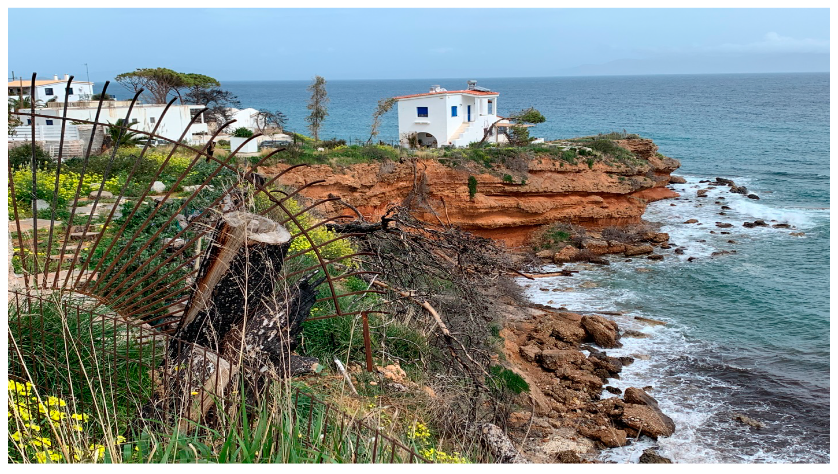
4.1. Fire Disaster in Mati Area and Spatial Impacts

On July 23, a very high fire danger rating (class 4 in the 1–5 range) was assigned in the region of Attica, and to a large part of southeastern continental Greece, in the Fire Danger Prediction map issued daily by the General Secretariat for Civil Protection [51]. The same day, a crown fire was initiated on the mountain Penteli (5.2 km west from the coast) driven by very high winds (90–120 km/h) and reached Mati in less than two hours [52], devastating the area. A total of 1.431 ha of forest, wildland, agricultural land, and WUI (Wildland Urban Interface) were burned [53] (Figure 1, Figure 2, Figure 3 and Figure 4).
The fire disaster that was caused was the deadliest in Europe [55] and the second deadliest worldwide in the past century [56]. The bodies of 83 people were found soon after the fire, 17 died in hospitals during the following days [51], and more in the following months and years. Of those, 26 people were trapped and died on a steep cliff above the sea, and more than 10 drowned in the sea before others were rescued by boats after having swam away from the burning coast [56]. More than 170 people were taken to the hospital [56].
Data from 4691 building inspections in the affected municipalities, Rafina-Pikermi and Marathona, show that only half of the buildings were assessed as usable (marked as “green”). In Mati, out of the inspected buildings, 23% were categorized as “not to be used until repaired” (“yellow”) and 28% as dangerous–heavily damaged (“red”) [57]. Concrete and masonry structures exhibited superior performance to steel and timber buildings [57], with buildings with a light timber framing system and plasterboards found to be more vulnerable to fire [58]. Besides the structural type, the most relevant indicators of the building’s vulnerability were the terrain slope and the roof material [52].
Research reveals significant psychological impacts. Ten months after the fire, more than 40% of adolescents participating in the sample were found to present with PTSD, nightmares, and sleep disorders (Newspaper ‘TA NEA’ 22/07/2021) [59]. Feelings of activation/vigilance, distress/disorientation, indignation, and helplessness, together with a decrease in the level of place attachment in the impacted area of Mati, were identified in the population of the disaster area with people with stronger emotional bonds with the place before the fire feeling more helpless during the fire [60]. The same study affirms that the stronger the place attachment is, the more intensive the need for recovery.
Secondary effects include environmental degradation and pollution, as well as an increase in soil erosion and flood risk. Long-term impacts involve health issues, ecological damage, and a wide range of economic impacts, such as a downturn in tourism, business, and recreation revenue. Compensation for insured losses was estimated to be over EUR 33.7 million [61].
Most human losses were reported in Mati’s densely populated coastal settlement, even though most damaged buildings were located on the mountain [51]. Xanthopoulos and Athanasiou [51], through their research based on interviews, video, and photographic footage information on social media and mass media information, affirm that many who tried to escape by car at the last moment were caught in traffic jams in the narrow and tangled streets by the seaside while some who continued to try to reach the sea on foot could not find a passage and found themselves trapped at the crest of the cliff with the fire approaching behind them. Very narrow streets, numerous cul-de-sacs, very long building blocks with no possibility of lateral escape, and absence of gathering places hindered the prompt and safe evacuation of the population [62].
Therefore, several factors were identified to have led to the disaster, besides weaknesses in the management of landscape fires in Greece [36], as well as the characteristics of the specific fire, such as the high rate of spread [53,63]. Many of those factors relate strongly to spatial planning or, instead, the lack of it; for one, lack of preparatory measures, failures in warning and direction from the authorities, and limited public knowledge on appropriate behavior in case of a wildfire [64]. Furthermore, vulnerability to fire was high in poor-quality buildings and informal housing that constituted a high percentage of the building stock. Last but not least, the chaotic intermix of housing, dense vegetation, and challenging topography affected both the fire spread and emergency evacuation [65]. In addition, the layout of the settlement, especially the complex urban tissue, as well as the lack of alternative routes to exit the settlement, hampered emergency evacuation and access of first responders.
In summary, as often happens, the disaster resulted from a range of causes, among them weaknesses in emergency planning and preparedness at all levels from national to houselold, faults in crisis communication and coordination, weak forest fire awareness and low risk perception, along with structural and territorial vulnerability to forest fires.
The appalling disaster shocked the Greek public, and various actors, mainly public agencies, were finger-pointed. Twenty-one persons are currently on trial for the death of 103 people and the injuring of 32. To ease public disappointment and anger, the Greek Prime Minister offered a public apology and visited the disaster area to directly interact with victims [65], where he announced that the government plans to take action for the recovery of the area and to support those who were affected. It should be noted that very soon after the disaster, public dialogue on the causes of the disaster brought up, among others, problems relating to the spatial development of Mati.

4.2. Reconstruction Vision and Spatial Planning

A proposal for the urban planning reorganization of the fire-stricken area in Mati, Attica, was prepared as part of the contribution of the Urban Planning Research Laboratory (UPRL) of the National Technical University of Athens (NTUA) to the preparation of the Special Urban Plan (SUP) for the fire-stricken area of Mati, Attica, on behalf of the Technical Chamber of Greece [19].
The proposal is aimed at the spatial distribution of rules based on (a) the data of the site at the present moment, (b) the existing laws of all types affecting the land regime, and (c) the pursuit of rational management and use of the site, with an emphasis on both ensuring a functional urban planning structure and limiting the study area’s vulnerability to risks from disasters (Figure 5).
The proposal’s vision is the spatial regeneration of Mati’s fire-stricken area. The spatial destination of the intervention area refers to an upgraded area of predominantly holiday housing and seaside recreation compared to the pre-fire period serving current and future needs without compromising environmental protection.
The reconstruction and redevelopment of the intervention area will be based on a new pattern of spatial organization conforming to the principles of sustainable development, rational organization of land use, pedestrian and vehicular traffic, preservation of natural resources, and ensuring safe conditions for all social groups of residents and visitors.
The proposal comprised a set of policy principles for the spatial organization of the study area that has been developed for the natural environment, road network and traffic, and waterfront revitalization.

4.3. Natural Environment

The risk of forest fires begins the day after a fire. Therefore, significant importance should be placed on prevention in all aspects throughout the entire region. Prevention includes, among other things, fuel management to reduce risk, the development of action plans based on potential scenarios, and the creation of “active” and “passive” safety and fire protection infrastructure, early detection of any fires that may occur, and public education to prevent negligent arson.

4.3.1. Protection from Fire

The area of Mati consists of distinct units with specific biophysical characteristics, such as campsites bounded by dense forest, plots of land surrounded by many trees, primarily pine and fruit trees, sparse forest areas, and scattered crops. The overall picture is complex but is primarily characterized by houses and facilities in the forest, a loose road network, the absence of squares and large, accessible areas, as well as isolation from the sea. Marathonos Ave. is a central longitudinal road axis that bisects the area. There are only a few access points to the coastline, no coastal hiking, and houses and other structures occupy the streams.
In addition, society needs to be more robust in recognizing the ongoing danger posed by forest fires, particularly in areas of this nature. Nonetheless, radical measures must be taken by implementing preventive interventions that will act “defensively” in a fire and gradually consolidate a perception of prevention among citizens. When designing interventions, the region should be viewed as a single forest-settlement complex, and the designed measures should aim to protect this complex. Treating the forest-settlement complex as a single entity will facilitate the development of effective fire management plans for diverse areas instead of fragmented areas.
Given the nature of the forest-settlement mix, conducting a “fire protection study” for the entire study area is necessary. The study must:
(a)
Examine the history of forest fires in this area, documenting information such as the origin, the front’s path, the prevalent climatic conditions, the damage, the contour, and the cause;
(b)
Develop fire scenarios from which operational plans can be derived. The organizations involved must implement the plans so that they are always prepared;
(c)
Define the ”protected” area so that critical interventions such as (i) the development of fire protection or “defense” zones (at the outer boundaries of individual units of the area) by clearing them of flammable vegetation and planting volatile species; and (ii) the development of safe shelter areas in case of fire with the possible use of land such as campsites, the EAFF, parts of properties within settlements, etc., can be implemented;
(d)
Propose planting resilient plant species in private gardens to create a zone containing a potential wildfire.
In addition, the “active” fire protection solution should be considered, which can supplement fire safety zones where it is impossible to secure large areas for special treatments and work in parallel and in combination wherever possible. This solution entails installing sprinkler systems (similar to agricultural sprinklers, such as rotor head sprinklers) to establish defense zones. Depending on the characteristics of the fire, defense zones may be designed to reduce the fire’s intensity or even prevent it from spreading further.
For plots and houses, it is the responsibility of the owners to assess the risk of destruction from a potential fire by evaluating the surrounding vegetation (quantity, density, and proximity) and the condition of the homes in terms of the fire resistance of the structural elements (wood, metal, concrete, plastic, etc.). In this process, the IMDO guidelines for “Housing Security from Forest Fires”, developed as part of the project “Contribution to the Prevention of Forest Fires with the INCA Methodology”, are a valuable resource [66].
A fundamental criterion for the possible planting and/or management of vegetation should be the use of non-flammable plant species, careful grading based on height, and the planned maintenance of safe distances from structures and dwellings. By selecting primarily non- or low-flammable species, a similar emphasis should be placed on planting along roadways so as to achieve a relative “discontinuity” in the vegetation with that of plots and gardens. Lastly, it is essential to ensure access for firefighting vehicles, etc., around the squares, which should be accompanied by the restriction or absence of plantings at specific distances in the periphery plots.

4.3.2. Recovery of Physical Capabilities

The Mati settlement expanded, developed uncontrollably, occupied all available space, and obstructed access to the sea, leaving behind a narrow, discontinuous strip that was nearly inaccessible. This development resulted in the disruption of natural processes, the fragmentation of habitats, and the elimination of small and large streams’ natural beds. For the well-being of the residents, it is essential to restore the natural functions, the most important of which is the unveiling of small and large stream beds to facilitate the outflow and exchange of natural elements.
Due to each area’s unique characteristics, each stream’s history and potential should be studied in depth. Existing institutional tools should be utilized to remove structures from the stream bed and implement necessary flood control measures. As part of this solution, vertical corridors could be constructed along the entire length of the coastline.

4.3.3. Forest Management Measures

In the Mati settlement, as in the cases of peri-urban residential areas, the combination of vegetation that will be installed in a natural or designed way, the natural ground vegetation around and inside the residential area, and the given urban planning situation can create difficult fire conditions at any time. In this case, the situation concerns the entire settlement and does not diverge spatially to the extent that individual units can be distinguished and demarcated. The whole area is therefore considered a high-risk area for fire. In the general context of prevention, a network of fire protection and defense zones can be organized that could, at the same time, be used as escape routes for evacuation of the area in case of fire or for moving residents to safe places [67]. Creating a slow or harmless zone of agricultural crops (olive trees, vines) along main roads, such as Marathon Ave., or settlement boundaries would be prudent to combat or slow the spread of fire.
In addition, since the largest percentage of fires are due to human negligence, special emphasis should be placed on informing the public about the risk of fire caused by negligence and the need to care for and maintain the vegetation in the defense zones.

4.4. Ensuring Safe Evacuation and Accessibility in Case of an Emergency

Today, due to “informal” rural building, Mati is a difficult-to-access settlement. After the tragedy of the fire, Mati can be considered a trap. As most trees have already been consumed by fire, a new blaze would produce different results under the current circumstances. A set of proposals was prepared to strengthen the settlement’s resilience to future disasters and to rebuild the traffic network following the principles of sustainable mobility.

4.4.1. Expand the Available Public Spaces

Mati lacks public spaces—roads and other open areas—capable of supporting the operation of a modern village, let alone its safe and prompt evacuation in an emergency. A sample comparison of 500 m radius sections of indicative settlements within Attica are presented. Table 1 shows that Mati lags significantly behind in accessible public spaces, ranking last, with only 11% of public spaces.
There is a clear need for new public locations, including roads and recreational and relaxation areas for residents, that can also serve as safe public gathering places in the event of a disaster.

4.4.2. Divisions of Building Blocks

The characteristics of the rural structure of the Mati area have no resemblance to those of the urban system. In urban areas, the size of the blocks is determined by the pedestrian’s need to move in any direction without long distances. Smaller blocks encourage walkability, increase the interest in movement within the settlement, and enhance the sense of security by preventing the formation of large, isolated areas while simultaneously increasing the active front of the blocks, thereby increasing their value, commercial exploitation potential, etc. Large blocks limit alternative evacuation routes in the event of an emergency evacuation of the settlement. In contrast, smaller blocks form networks with numerous alternative exit routes from the settlement.
In Mati, building blocks with an average perimeter of 750 m are observed. Several building blocks have a perimeter greater than a kilometer, necessitating a walking period of more than 15 min for patrolling (Figure 6).
Even without fire, blocks with such large sides are dangerous. Moreover, in the event of an emergency evacuation of the settlement, the currently existing dead-end roads can trap civilians in the area. It is argued that if Mati does not receive a new road network, vehicles and pedestrians will risk becoming trapped, with all the associated dangers.
Long distances between intersections encourage motorists to travel at high speeds (in the Mati settlement, before the fire, the spaces between intersections at the ends of the major sides were as high as 550 m, with the average being around 430 m). It should be noted that the long sides of the blocks in New York, which are renowned for their size, is 270 m; in Paris, it is 250 m; in Barcelona, it is 140 m; and in Athens, it is less than 100 m.
Consequently, there are no intersections in the Mati area, which results in the absence of cross-streets (along the narrow sides of the blocks), particularly in the Mati settlement before the fire, which divided the unsuitable parcels of land into smaller ones. Opening such transverse road segments should not result in long roads competing with Marathonos Ave. This would undermine the organization of a prioritization plan to ensure sustainable mobility conditions between the coastline and Marathonos Ave. For this reason, the aforementioned road segments should not form continuous routes but rather should be segmented, and their widths should be restricted (Figure 7).
In the case of the Mati area, narrow roads prevent high speeds. This feature should be preserved. Therefore, when Mati’s roads are to be widened, the space gained should only be used to create sidewalks and/or parking, and not for road widening. The fact that there may be sidewalks is no reason to accept higher speeds in a recreation area, where pedestrians cross from any side of the street, from one sidewalk to another, and children play. Bicyclists ride in the middle of the road without dedicated lanes but coexist with cars. In other words, with a speed limit of 30 km/h, it is a typical light traffic zone.
It should be noted that this scheme is valid and can be supported because the entire linear zone between Marathonos Ave. and the coast is a zone “hanging” from Marathonos Ave., which is responsible for inter-regional movement so that the zone above does not have through-flows. Parallel to Marathonos Ave., the zone has no other axis from Rafina to Schinia. Only a few road segments, such as Republic, Cyprus, and Poseidonos Ave., are suitable for short-distance movement because of their broken lines and narrow width. This characteristic of the Mati area should not be modified. The capacity of Marathonos Ave. is adequate.

4.4.3. Satisfactory Road Dimensioning

Concurrently, the widening and adequate dimensioning of roads estimated to accommodate an increased number of pedestrians or vehicles (private or civil protection) in the event of settlement evacuation should be considered. In the case of the Mati fire, dozens of cars were trapped on the coastal roads of Poseidonos Ave. and Democritus Str.—the only road connecting Mati to southern settlements with an irrational layout and a total width of 6 to 8 m.
Additionally, safety at intersections must be ensured. The intersections of narrow roads without sidewalks are highly hazardous because drivers cannot see oncoming traffic from vertical routes.
Even if few streets will be widened and have sidewalks, corner lots must provide two 2 × 5 wide sections, one on each lane side beginning at the corner, to form a C of 2 m wide and 5 m long sidewalks entering the lots, ensuring visibility to vehicles passing through the intersection.

4.4.4. Creation of a Secure Evacuation Network for the Settlement

Parallel to the development of the road network, the location of safe public gathering places must be considered, and safe access to them must be ensured through the absence of natural or other obstacles (streams, highways, etc.), the lack of elements vulnerable to explosions and fires, adequate distances from buildings, etc. Priority should be given to placing public gathering places within the settlement so that access from residences is via a pedestrian evacuation network that spans the entire settlement. In the event of an earthquake, the maximum acceptable distance for the pedestrian approach to sites within the urban fabric is approximately 300–400 m, or approximately 5′–6′ of fast walking.
In many instances, even when a settlement evacuation plan is in place, citizens initiate evacuation independently due to the increased speed of natural catastrophes, which do not allow for formal population warning. It has been observed that when evacuating communities, people tend to use familiar or easily recognizable escape routes. Evaders frequently choose the entrance route as their escape route. In this regard, when designing urban and settlement evacuation plans, it should be kept in mind that escape routes to public gathering places should be familiar to residents or easily identifiable to visitors; routes that are also used in the daily life of the settlement, without many turns and with a wide field-of-vision.

4.4.5. Integration of the Coastal Zone into the Settlement’s Traffic Network

The management of the settlement’s coastal zone will play a crucial role. Drafting the new LUP for the Mati area presents an opportunity to create a modern vacation community with a distinct identity based on sustainable mobility principles. Regarding the structure of the new traffic network, consideration should be given to the extension of pedestrian and bicycle routes in the coastal zone through appropriately located access points and landscaped roads. Citizens should be able to park near the coast so that Poseidonos Ave. remains unobstructed and is landscaped properly for pedestrians and cyclists.

4.5. Waterfront Revitalisation

Regarding the coastline, the proposed interventions promote the expansion and improvement of the public nature of the coastal zone, the elimination of incompatible uses and decongestion of extensive, intensive, or exclusive exploitations and activities, the increase in accessibility by facilitating pedestrian and bicycle access along the entire length of the coastal zone, and, by constructing steep footpaths of sufficient width to connect the road network to the coast, the equal access to the waterfront for all social groups.
Priority should be given to removing fencing from the coastal zone between Poseidonos Ave. and the coastline at Mati and the coastline at Kokkino Limanaki; promoting the seafront and creating a single coastal promenade from Rafina to Zouberi through the Intervention Area; and enhancing the coastal and seaside landscape (Figure 8). It was regarded to be essential, in the context of the proposed actions for the waterfront, to prepare a proposal for the regeneration of the Mati community’s coastal zone, with an emphasis on the readjustment of the public-private partnership.
The central concept of the proposal is constructing a three km long coastal path from Kokkinos Limakaki to Agios Andreas along the “eyebrow” of the coastline. The path will be accessible from the coastal road (Poseidonos Ave.) by opening access passages between the properties. It will provide public access to the beaches and sea via steps adapted to the morphology of the coastline.
This intervention promotes public safety through accessibility, the expansion of public space through the creation of a grand promenade in a developing settlement, and the regeneration of a damaged coastal landscape to mitigate property loss and direct future private investment in the proper direction.

5. Integrating Disaster Risk Reduction and Disaster Management into Spatial Planning in Greece: General Guidelines

Legislative and regulatory frameworks, when properly utilized, can prevent the development of (formal and informal) settlements on hazard-prone land, allow for the provision of safe land, and establish risk-reducing designs and construction standards.
Legislation must be proactive and preventative, not merely reactive to disasters as they occur. Legislation of spatial planning should emphasize that less emphasis should be placed on drafting detailed regulations and more on permitting greater implementation flexibility following local development requirements, accessibility, and affordability. Less prescriptive legislation, on the other hand, necessitates (a) multi-stakeholder participation in its formulation, including representatives of government agencies, organizations, civil society, experts, and those representing private interests, and (b) more sophisticated decision-making mechanisms during project preparation or project approval to determine whether a project or construction meets legislative requirements [68].
The various types of spatial planning influence the location, the type of development permitted in certain areas, the quality of development, and the delivery schedule for infrastructure projects and construction. By designating such areas for non-sensitive uses, such planning can reduce or avoid the risk created by local parameters, such as floodplains (e.g., parks). In terms of risk reduction, multifunctional land use is also crucial. Schools and other public buildings may serve as shelters during and after a disaster. Open areas and parking lots can serve as refuges. In addition, spatial plans and land use designations should consider the opportunities and constraints created by the conditions below the ground’s surface, where extremely vital infrastructure is typically located, and where opportunities for risk reduction can frequently be realized.
Incorporating risk reduction into spatial planning can also facilitate disaster response and recovery. Through proper regulation of urban form and layout, spatial plans can enhance emergency response. This can include strategically providing open spaces and well-designed road networks for rescue operations. There are a variety of spatial plans with varying purposes, strengths, and weaknesses.
Urban development and infrastructure projects include roads, transportation, telecommunications, health care facilities, education, open spaces, and water and sewage infrastructure. As urban areas grow in population and density, the complexity of their infrastructure increases. Therefore, resilient infrastructure systems must be able to “anticipate, absorb, adapt, and recover rapidly from a disaster” [3]. Although urban infrastructure projects should be based on long-term strategic plans, in practice, many development projects are influenced by private sector investment plans or funding opportunities. In these instances, long-term strategic planning is only sometimes taken into account.
In poor planning and urban development based primarily on private sector projects, disaster risk reduction is crucial and challenging to implement. Private sector decisions regarding the location and construction methods affect disaster risk, exposing the public sector and the local community to the repercussions of potential disasters.
Urban development and infrastructure projects can contribute to disaster resilience by identifying, through SEA, how they may affect natural systems and enhance or restore degraded urban natural environments through appropriate planning, operating as underground or ground backup structures spaces (e.g., parking garages, pylons).
Sensitive uses such as hospitals, schools, community centers, archive storage facilities, and critical infrastructure can be protected by spatial planning regulations by, for example, locating them in less hazardous areas. In terms of regulations, good practice may entail relaxing specific requirements (e.g., providing for smaller plot sizes to ensure accessibility to services for the economically disadvantaged residents of the city). On the basis of a realistic approach to development pressures on land, less regulation could also entail a greater emphasis on planning as opposed to land management to make desirable sites safer.
Building codes and standards can reduce risk by imposing restrictions on building types, uses, ownership, density, and high-risk locations. Standards, building codes, and land-use zoning should be flexible and responsive to the local context for informal and marginalized settlements. The implementation and enforcement of standards should be proportional to a location’s capacity to implement and maintain them.
As it pertains to numerous cities in low- and middle-income countries, it is essential to remember that only a small portion of urban developments follow official plans. Many informal urban development processes and activities do not comply with development control regulations, making them susceptible to natural and man-made disasters. Informal urban development settlements may be situated in high-risk areas or comprise non-resilient building materials, technologies, and a need for basic infrastructure. Therefore, disseminating information on safe building techniques and development areas should be crucial.
As in Mati, violating controls and regulations—and thereby reducing disaster risk—in haphazardly built-up areas is frequently used to expel individuals and groups from land they may have occupied for a considerable time. However, eviction or relocation is rarely effective in reducing disaster risk. With strong stakeholder engagement, infrastructure upgrades or improvements can improve outcomes for individuals and cities.
Spatial planning can and should adapt to the reality of multiple planning actors and adopt a multi-stakeholder engagement strategy to address disaster risk effectively and build resilience in informal settlements. Through agreements and negotiations with local communities and other stakeholders, it is possible to construct basic infrastructure, provide public services, and reduce disaster risk in settlements that are developed informally.
Last but not least, a shift in thinking regarding the function of spatial planning is required to promote risk reduction. Starting from earthquake protection, spatial planners consider disaster risk reduction mainly as an area of expertise of the geosciences and engineering [69]. They also perceive disaster management as an organizational matter concerning, primarily, civil protection. Neither their studies nor their focus raise their awareness of their highly significant role in these fields. Moreover, spatial planners are usually left aside in disaster reconstruction and Build-Back-Better, nor are they considered a prime player in disaster risk reduction. To this end, spatial factors in the Mati fire disaster and the role of spatial planning in the reconstruction of the area can enhance awareness of planners and initiate closer synergies between spatial planning and other disciplines towards reducing disaster risk and better responding to disasters.

Author Contributions

Conceptualization, M.L., M.D. and K.S.; methodology, M.L., M.D. and K.S.; validation, M.L., M.D., N.P. and K.S.; formal analysis, M.L. and M.D.; investigation, M.L. and M.D.; data curation, M.L., M.D. and K.S.; writing—original draft preparation, M.L. and M.D., writing—review and editing, K.S.; visualization, M.L. and K.S.; supervision, K.S.; project administration, K.S. All authors have read and agreed to the published version of the manuscript.

Funding

This research received no external funding.

Institutional Review Board Statement

Not applicable.

Informed Consent Statement

Not applicable.

Data Availability Statement

Conflicts of Interest

The authors declare no conflict of interest.

References

  1. Shaw, R.; Banba, M. Land Use Management in Disaster Risk Reduction: An Overview. In Land Use Management in Disaster Risk Reduction Practice and Cases from a Global Perspective; Shaw, R., Banba, M., Eds.; Springer: Tokyo, Japan, 2017; pp. 1–12. [Google Scholar]
  2. United Nations (UN). The Sendai Framework for Disaster Risk Reduction 2015–2030. 2015. Available online: https://www.preventionweb.net/publications/view/43291 (accessed on 6 March 2023).
  3. United Nations (UN). Transforming Our World: The 2030 Agenda for Sustainable Development; UN General Assembly Resolution; UN: New York, NY, USA, 2015; 35p. [Google Scholar]
  4. Lazoglou, M. Resilience as a Spatial Planning Parameter against the Effects of Climate Change: The Significance of Greek Medium Coastal Cities and the Role of Modern Technologies. Ph.D. Thesis, National Technical University of Athens, Athens, Greece, 2022. [Google Scholar]
  5. IPCC. Climate Change and Land: An IPCC Special Report on Climate Change, Desertification, Land Degradation, Sustainable Land Management, Food Security, and Greenhouse Gas Fluxes in Terrestrial Ecosystems. 2019. Available online: https://www.ipcc.ch/site/assets/uploads/sites/4/2020/02/SPM_Updated-Jan20.pdf (accessed on 14 March 2023).
  6. OECD. Towards Sustainable Land Use: Aligning Biodiversity, Climate and Food Policies—Towards Sustainable Land Use: Key Issues, Interactions and Trade-Offs in the Land-Use Nexus; OECD: Paris, France, 2020. [Google Scholar] [CrossRef]
  7. Wamsler, C.; Brink, E.; Rivera, C. Planning for Climate Change in Urban Areas: From Theory to Practice. J. Clean. Prod. 2013, 50, 68–81. [Google Scholar] [CrossRef] [Green Version]
  8. Shamsuddin, S. Resilience resistance: The challenges and implications of urban resilience implementation. Cities 2020, 103, 102763. [Google Scholar] [CrossRef]
  9. Cuny, F. Disasters and Development; Oxford University Press: London, UK, 1983. [Google Scholar]
  10. Blaikie, P.; Cannon, T.; Davis, I.; Wisner, B. At Risk: Natural Hazards, People Vulnerability and Disasters, 1st ed.; Routledge: London, UK, 1994. [Google Scholar]
  11. Bankoff, G.; Frerks, G.; Hilhorst, D. Mapping Vulnerability: Disasters, Development and People; Earthscan: London, UK, 2004. [Google Scholar]
  12. Pelling, M. The Vulnerability of Cities: Natural Disasters and Social Resilience; Earthscan: London, UK, 2003. [Google Scholar]
  13. Bankoff, G.; Hilhorst, D. (Eds.) Why Vulnerability Still Matters; Routledge: London, UK; New York, NY, USA, 2022. [Google Scholar]
  14. Kelman, I. Disasters by Choice; Oxford University Press: Oxford, UK, 2020. [Google Scholar]
  15. Agnelli, D.; Tajani, F.; Ranieri, F. Urban resilience against natural disasters: Mapping the risk with an innovative indicators-based assessment approach. J. Clean. Prod. 2022, 371, 133496. [Google Scholar] [CrossRef]
  16. Pilone, E.; Demichela, M.; Baldissone, G. The Multi-Risk Assessment Approach as a Basis for the Territorial Resilience. Sustainability 2019, 11, 2612. [Google Scholar] [CrossRef] [Green Version]
  17. Sapountzaki, K.; Michellier, C.; Pigeon, P.; Rebotier, J.; Daskalakis, I. A Risk-Based Approach to Development Planning. In Disaster Risk Reduction for Resilience: Disaster and Social Aspects; Springer International Publishing: Cham, Switzerland, 2022; pp. 265–311. [Google Scholar]
  18. BMZ. Land Use Planning: Concept, Tools and Applications; GIZ: Bonn, Germany, 2012.
  19. Urban Planning Research Lab (UPRL). Investigation of a Framework of Generic Proposals and Guidelines for the Urban Management and Redevelopment of Residential Areas with Significant Urban Problems and Increased Vulnerability to Natural Disasters, Research and Scientific Support of Technical Chamber of Greece during the Process of Preparing the Special Spatial Plan for the Fire-Striken Area of ‘Mati’; Urban Planning Research Lab: Athens, Greece, 2020. [Google Scholar]
  20. Pozoukidou, G.; Chatziyiannaki, Z. 15-Minute City: Decomposing the new urban planning eutopia. Sustainability 2021, 13, 928. [Google Scholar] [CrossRef]
  21. Räsänen, A.; Lein, H.; Bird, D.; Setten, G. Conceptualizing community in disaster risk management. Int. J. Disaster Risk Reduct. 2020, 45, 101485. [Google Scholar] [CrossRef]
  22. Stead, D.; Nadin, V. Spatial Planning: Key Instrument for Development and Effective Governance with Special Reference to Countries in Transition; United Nations: New York, NY, USA, 2008. [Google Scholar]
  23. McEntire, D.A. Disaster Response and Recovery: Strategies and Tactics for Resilience; John Wiley & Sons: Hoboken, NJ, USA, 2021. [Google Scholar]
  24. Rehman, J.; Sohaib, O.; Asif, M.; Pradhan, B. Applying systems thinking to flood disaster management for a sustainable development. Int. J. Disaster Risk Reduct. 2019, 36, 101101. [Google Scholar] [CrossRef]
  25. Meerow, S.; Newell, J.P.; Stults, M. Defining urban resilience: A review. Landsc. Urban Plan. 2016, 147, 38–49. [Google Scholar] [CrossRef]
  26. Lazoglou, M.; Serraos, K. Climate change adaptation through spatial planning: The case study of the region of Western Macedonia. In IOP Conference Series: Earth and Environmental Science; IOP Publishing: Bristol, UK, 2021; Volume 899, p. 012021. [Google Scholar]
  27. Lazoglou, M.; Angelides, D.C. Development of a spatial decision support system for land-use suitability assessment: The case of complex tourism accommodation in Greece. Res. Glob. 2020, 2, 100022. [Google Scholar] [CrossRef]
  28. Sanchez, A.X.; Van der Heijden, J.; Osmond, P. The City Politics of an Urban Age: Urban Resilience Conceptualisations and Policies. Palgrave Commun. 2018, 4, 25. [Google Scholar] [CrossRef] [Green Version]
  29. Threlfall, C.G.; Kendal, D. The distinct ecological and social roles that wild spaces play in urban ecosystems. Urban For. Urban Green. 2018, 29, 348–356. [Google Scholar] [CrossRef]
  30. Del-Pinto, M. Urban Form and Disaster Risk: The Role of Urban Public Open Spaces in Vulnerability of Earthquake-Prone Settlements; Loughborough University: Loughborough, UK, 2022. [Google Scholar] [CrossRef]
  31. García Fernández, C.; Peek, D. Smart and sustainable? Positioning adaptation to climate change in the European smart city. Smart Cities 2020, 3, 511–526. [Google Scholar] [CrossRef]
  32. Lazoglou, M.; Angelides, D.C. Development of an Ontology for Modeling Spatial Planning Systems. Curr. Urban Stud. 2016, 4, 241–255. [Google Scholar] [CrossRef] [Green Version]
  33. World Bank. Inputs and Recommendations for the Development of a Draft NDRM Plan for Greece. Report I the Framework of Technical Assistance to the Ministry for Climate Crisis and Civil Protection. 2021. Available online: https://www.civilprotection.gr/sites/default/gscp_uploads/en_drm_plan.pdf (accessed on 6 March 2023).
  34. Dynes, E.R. Community emergency planning: False assumptions and inappropriate analogies. Int. J. Mass Emergencies Disasters 1990, 12, 141–158. [Google Scholar] [CrossRef]
  35. Dandoulaki, M. Review of earthquake protection policies in Greece in the period 1975–2005. In Futures at Risk; Sapountzaki, K., Ed.; Gutenberg: Athens, Greece, 2007; pp. 159–192. (In Greek) [Google Scholar]
  36. Independent Committee Tasked to Investigate the Underlying Causes and Explore the Perspectives for the Future Management of Landscape Fires in Greece. Report on the Underlying Causes and Explore the Perspectives for the Future Management of Landscape Fires in Greece. 2019. Available online: https://gfmc.online/wp-content/uploads/FLFM-Greece-Committee-Report-07-February-2019.pdf (accessed on 6 March 2023). (In Greek).
  37. Dandoulaki, M. Emergency Evacuation in Case of an Imminent or an Ongoing Disaster in Greece: A Comment. 2020. Available online: https://safegreece.org/safegreece2020/images/docs/safegreece2020_proceedings.pdf (accessed on 6 March 2023).
  38. Dandoulaki, Μ.; Karympalis, Ε.; Skordili, S. Contemporary issues of natural and man-made disasters. In The New Agenda in Greece at Times of Crisis; ΚΨΜ: Athens, Greece, 2018. [Google Scholar]
  39. Dandoulaki, M. Aspects of resilience in the reconstruction of Kalamata (Greece) after the earthquake disaster of 1986. In Urban Resilience, Climate Change and Adaptation; Othengrafen, F., Serraos, K., Eds.; Leibniz Universität Hannover, Institut für Umweltplanung: Hannover, Germany, 2018; pp. 67–84. [Google Scholar]
  40. Mousteraki, K.; Dandoulaki, M.; Symeonidis, S. Assessment of an alternative housing reconstruction policy after the 1995 Grevena-Kozani (N. Greece) earthquake: Construction of standardized units in private lots. In Proceedings of the European Geosciences Union General Assembly, EGU 2009, Vienna, Austria, 19–24 April 2009. [Google Scholar]
  41. Sapountzaki, K.; Dandoulaki, M. Coping with Seismic Risk in Greece: The Traditional Merits of the System and the Challenges of the Future. In Natural Hazards and Spatial Planning in Europe; Fleischhauer, M., Greiving, S., Wanczura, S., Eds.; Partly Financed by the European Commission; Bau- und Planungsliteratur: Dortmund, Germany, 2006; pp. 77–95. [Google Scholar]
  42. Greiving, S.; Ubaura, M.; Tešliar, J. Spatial Planning and Resilience Following Disasters: International and Comparative Perspectives; Policy Press: Bristol, UK, 2017. [Google Scholar]
  43. Geipel, R. Disaster and Reconstruction; George Allen and Unwin: London, UK, 1982. [Google Scholar]
  44. Schwab, J. Planning for Post-Disaster Recovery: Next Generation; PAS Report 576; APA Planning Advisory Service: Chicago, IL, USA, 2014. [Google Scholar]
  45. Shaw, R. (Ed.) Disaster Recovery: Used or Misused Opportunity; Springer: Tokyo, Japan, 2014. [Google Scholar]
  46. Davis, I.; Alexander, D. Recovery from Disaster; Routledge: London, UK, 2017. [Google Scholar]
  47. March, A.; Leon, J. Urban Planning for Disaster Risk Reduction: Establishing 2nd Wave Criteria. In Proceedings of the 6th State of Australian Cities Conference, Sydney, Australia, 26–29 November 2013. [Google Scholar]
  48. Galderisi, A.; Guida, G.; Limongi, G. Emergency and spatial planning towards cooperative approaches. Special Issue 1.2021. TEMA J. Land Use Mobil. Environ. 2021, 1, 73–92. [Google Scholar] [CrossRef]
  49. Vitopoulou, A.; Yiannakou, A. Public land policy and urban planning in Greece: Diachronic continuities and abrupt reversals in a context of crisis. Eur. Urban Reg. Stud. 2020, 27, 259–275. [Google Scholar] [CrossRef]
  50. Papageorgiou, M. Spatial planning in transition in Greece: A critical overview. Eur. Plan. Stud. 2017, 25, 1818–1833. [Google Scholar] [CrossRef]
  51. Xanthopoulos, G.; Athanasiou, M. Attica Region, Greece July 2018: A tale of two fires and a seaside tragedy. Wildfire 2019, 28, 18–21. [Google Scholar]
  52. Papathoma-Köhle, M.; Schlögl, M.; Garlichs, C.; Diakakis, M.; Mavroulis, S.; Fuchs, S. A wildfire vulnerability index for buildings. Nat. Sci. Rep. 2022, 12, 6378. [Google Scholar] [CrossRef] [PubMed]
  53. Athanasiou, M.; Xanthopoulos, G. Behavior of the deadly fire of 23 July 2018 in Western Attica. In Proceedings of the 20th Panhellenic Forestry Conference, Trikala, Greece, 3–6 October 2021. (In Greek with English Abstract). [Google Scholar]
  54. Serraos, K. (Architect-Urban Planner, National Technical University of Athens, 106 82 Athens, Greece). Personal Photographic file, Athens. Unpublished work. 2021. [Google Scholar]
  55. Molina-Terre, D.M.; Xanthopoulos, G.; Diakakis, M.; Ribeiro, L.; Caballero, D.; Delogu, M.G.; Viegas, D.X.; Silva, C.A.; Cardil, A. Analysis of forest fire fatalities in Southern Europe: Spain, Portugal, Greece and Sardinia (Italy). Int. J. Wildland Fire 2019, 28, 85–98. [Google Scholar] [CrossRef] [Green Version]
  56. Haynes, K.; Short, K.; Xanthopoulos, G.; Viegas, D.; Ribeiro, L.M.; Blanchi, R. Wildfires and WUI fire fatalities. In Encyclopedia of Wildfires and Wildland-Urban Interface (WUI) Fires; Manzello, S.L., Ed.; Springer: Cham, Switzerland, 2020; 16p. [Google Scholar]
  57. Papalou, A.; Baros, K.D. Assessing structural damage after a severe wildfire: A case study. Buildings 2019, 9, 171. [Google Scholar] [CrossRef] [Green Version]
  58. Stanota, E.-S.; Mavroulis, S.; Diakakis, M.; Gogou, M.; Kotsi, E.; Spyrou, N.-I.; Andreadakis, E.; Lekkas, E.; Carydis, P. Preliminary results of the building damage assessment after the July 2018 Eastern Attica (Central Greece) wildfire based on building-by-building inspection and Unmanned Aircraft Vehicle (UAV) survey. In Geophysical Research Abstracts; EGU2019-17263; Copernicus GmbH: Göttingen, Germany, 2019; Volume 21. [Google Scholar]
  59. Newspaper “TA NEA” (22/07/2021) Mati 3 years after: The traumatic imprint on children and adolescents. Available online: https://www.tanea.gr/2021/07/23/greece/fotia-sto-mati-to-traymatiko-apotypoma-se-paidia-kai-efivous/ (accessed on 14 March 2023).
  60. Vallianou, K.; Alexopoulos, T.; Plaka, V.; Seleventi, K.M.; Skanavis, V.; Skanavis, C. Building resilient communities: The traumatic effect of wildfire on Mati, Greece. Int. J. Psychol. Behav. Sci. 2020, 14, 411–418. [Google Scholar]
  61. Hellenic Insurance Companies Association. Report About the Investigation of the Causes of Fires in the Framework of the Prime Ministerial Decision Y60/2018; Government Gazette; Law 3937/Β/10.9.2018; Athens, Greece, 2018.
  62. Lekkas, E.; Carydis, P.; Lagouvardos, K.; Mavroulis, S.; Diakakis, M.; Andreadakis, E.; Gogou, M.E.; Spyrou, N.I.; Athanassiou, M.; Kapourani, E.; et al. The July 2018 Attica (Central Greece) Wildfires—Scientific Report (Version 1.0). Newsl. Environ. Disaster Crisis Manag. Strateg. 2018, 8. [Google Scholar] [CrossRef]
  63. Lagouvardos, K.; Kotroni, V.; Giannaros, T.M.; Dafis, S. Meteorological conditions conducive to the rapid spread of the deadly wildfire in Eastern Attica, Greece. Bull. Am. Meteorol. Soc. 2019, 100, 2137–2145. [Google Scholar] [CrossRef]
  64. Athanasiou, M.; Xanthopoulos, G. Observations on wildfire spotting occurrence and characteristics in Greece. In Proceedings of the 8th International Conference on Forest Fire Research: Advances in Forest Fire Research, Coimbra, Portugal, 9–16 November 2018; Viegas, D.G., Ed.; University of Coimbra: Coimbra, Portugal, 2018; pp. 588–597. [Google Scholar]
  65. Gkinopoulos, T. Victim-focused political apology predicts political support via perceived sincerity, trust and positive emotional climate: The case of the 2018 bushfire in Attica. J. Soc. Political Psychol. 2022, 10, 475–490. [Google Scholar] [CrossRef]
  66. Xanthopoulos, G.; Roussos, A. Contribution to the Prevention of Forest Fires according to the INCA Methodology; Special Secretariat for Forests, General Directorate of Development and Protection of Forests and Natural Environment, Green Fund, YPEKA: Athens, Greece, 2014. [Google Scholar]
  67. Pangas, N.; Apostolidis, E. Environmental planning directions in peri-urban residential areas and scattered settlements vulnerable to forest fires. In Proceedings of the International Conference on “Changing Cities V”: Spatial, Design, Landscape, Heritage & Socio-Economic Dimensions, Corfu Island, Greece, 20–25 June 2022. [Google Scholar]
  68. Johnson, C. Creating an Enabling Environment for Reducing Disaster Risk: Recent Experience of Regulatory Frameworks for Land, Planning and Building in Low and Middle-Income Countries; Background Paper Prepared for the Global Assessment Report on Disaster Risk Reduction 2011; UN-ISDR: Geneva, Switzerland, 2011. [Google Scholar]
  69. Dandoulaki, M. Spatial Protection and Earthquake Protection in Greece. Ph.D. Thesis, School of Architecture, National Technical University of Athens, Athens, Greece, 2008. (In Greek). [Google Scholar]
Figure 1. The inaccessible coastal front of Mati, blocked through fences and private properties [54].
Sustainability 15 09776 g001
Figure 2. Overview of the Mati area from the nearby mountains after the disaster [54].
Sustainability 15 09776 g002
Figure 3. Example of the destroyed forest areas of the surrounding mountains [54].
Sustainability 15 09776 g003
Figure 4. The current structure of the road network and relative urban fabric of the fire-stricken Mati neighborhood [54].
Sustainability 15 09776 g004
Figure 5. Structure of the spatial regeneration proposal for the Mati.
Sustainability 15 09776 g005
Figure 6. Average building block perimeter in indicative settlement types in the Attika region, Source: [19] edited by the authors.
Sustainability 15 09776 g006
Figure 7. An indicative proposal for a road network within the settlement of Mati, aiming at creating transversal roads to segment the building blocks and considering the location of the preserved buildings in good condition. The existing roads are represented by a black colour, while the proposed roads are represented by a red colour. Source: [19].
Sustainability 15 09776 g007
Figure 8. A proposed future vision for the rearrangement of the road network in the greater Mati area. Red line: the current and proposed supra-local road network (Marathonos Ave.) up to Rafina, in connection with requisite parking space. Yellow line: the proposed local coastal road of Mati (Poseidonos Ave./Democratias St.). Green line: the proposed new coastal path, to be created along the coastal zone facilitating a new public accessible walking zone. Dotted line: proposed intervention. Source: [19].
Sustainability 15 09776 g008
Table 1. Spatial characteristics of indicative settlement types in the Attica region.
Central Housing AreasSuburban Housing AreasSuburban SettlementsMati
Settlement
Percentage of common spaces22.3%22.7%14.3%11.0%
Average perimeter of economic square (m)272.3412.7533.0751.0
Width of narrowest street (m)6.57.35.13.5
Width of widest street (m)12.915.514.59.1
Source: [19].
Disclaimer/Publisher’s Note: The statements, opinions and data contained in all publications are solely those of the individual author(s) and contributor(s) and not of MDPI and/or the editor(s). MDPI and/or the editor(s) disclaim responsibility for any injury to people or property resulting from any ideas, methods, instructions or products referred to in the content.

